Article

The Spatiotemporal Dynamics of Temperature Variability Across Mts. Qinling: A Comparative Study from 1971 to 2022

1
School of Surveying and Land Information Engineering, Henan Polytechnic University, Jiaozuo 454003, China
2
School of Resources and Environment, Henan Polytechnic University, Jiaozuo 454003, China
*
Author to whom correspondence should be addressed.
Sustainability 2024, 16(21), 9327; https://doi.org/10.3390/su16219327
Submission received: 9 September 2024 / Revised: 18 October 2024 / Accepted: 22 October 2024 / Published: 27 October 2024
(This article belongs to the Section Air, Climate Change and Sustainability)

Abstract

:
Analyzing the spatiotemporal patterns of atmospheric temperature in sensitive areas is critically important for understanding the broader implications of global climate change, which remains a prominent topic in geosciences. It also plays a crucial role in advancing sustainable development. This study utilized daily minimum, maximum, and mean temperature data from twelve meteorological stations across the South and North Mts. Qinling (Qinling Mountains). Employing trend analysis, the Mann–Kendall mutation test, and Morlet wavelet analysis, we explored the predominant temperature trends and characteristics from 1971 to 2022. Our findings revealed consistent inter-annual warming trends in both regions, with more rapid temperature increases in the North compared to the South. Notably, significant shifts occurred in 2003 for both mean and minimum temperatures in the North, while the maximum and minimum temperature values were recorded in the 2010s and 1980s, respectively. Both regions exhibited a primary temperature fluctuation cycle of 28 years. Seasonally, the strongest warming effects appeared in spring, with the weakest in autumn, and moderate effects in winter and summer, indicating that spring contributes most significantly to regional warming. Monthly analysis showed positive temperature trends across all months, with higher rates in the North. The weakening temperature boundary effect of the Mts. Qinling suggested a weakening North–South division, particularly highlighted by the northward shift of the 1 °C isotherm curve for the coldest month, moving away from the previously observed 0 °C isotherm. This northward shift highlights the differential warming rates between the northern and southern regions. Overall, the analysis confirms a robust warming trend, with notable fluctuations in January’s temperatures since 1998, suggesting the Mts. Qinling’s emerging role as a climatic divider in the Chinese Mainland. This introduces new challenges for regional ecosystems, agricultural production, and water resource management, highlighting the pressing need to advance regional sustainable development in the face of climate change.

1. Introduction

Global changes have had far-reaching impacts, with China’s warming trend becoming increasingly evident [1,2]. Studying temperature variations is crucial for uncovering patterns of climate change and their environmental impacts. Over the past century, the global climate system has undergone significant transformations that have influenced both the natural environment and various aspects of human society. These effects are manifested directly in terrestrial ecosystem components such as landforms, climate, hydrology, soil, and vegetation while indirectly influencing human health, settlements, and social ecology [3,4]. Additionally, the altered global climate system has intensified the frequency, intensity, spatial extent, and duration of extreme climatic and weather events, including severe heat and cold spells, prolonged droughts, and heavy precipitation [5,6]. Consequently, the social implications of climate change are significant and increasing in severity [7]. According to the sixth assessment report of the Intergovernmental Panel on Climate Change (IPCC), the regional temperature response in China within the context of global climate change mirrors that of the northern hemisphere, albeit with notable differences in the specific processes and magnitudes of change [8,9].
The Mts. Qinling (Qinling Mountains), recognized as the geographical and ecological boundary between Northern and Southern China, host a complex and diverse ecosystem. This area has been central to regional response research in China, particularly regarding global warming [10,11,12,13,14]. As global temperatures continue to rise, the Qinling region has exhibited notable seasonal fluctuations and spatial disparities. The increasing frequency of extreme climate events further intensifies the strain on the ecological environment and poses challenges to social and economic development. Analyzing the trends of climate change in the Qinling region is essential for local ecological preservation. With ongoing research into the climatic variations between the southern and northern areas of Qinling, many new patterns of regional climate response are emerging. Historically, Zhu Kenzhen recognized the Mts. Qinling in the 1950s as the dividing line between the northern subtropical zone and the warm temperate zone, utilizing core indicators such as the coldest month temperature, accumulated temperature ≥10 °C, and frost-free period. This classification aligns with the boundary between the coldest month’s 0 ℃ isotherm and the annual precipitation of 800 mm isotherm separating the North and South Chinese Mainland [15]. Subsequent research has reinforced these findings, highlighting temperature increases across the region. For instance, Xu et al. [16] observed an upward trend in annual temperatures in the Mts. Qinling, with synchronous trends despite varying amplitudes between the northern and southern regions. Similarly, Li et al. [17] documented synchronized temperature increases from 1961 to 2009 in both the northern and southern parts of the Mts. Qinling, highlighting an escalating warming trend. Additionally, Li et al. [18] reported a decrease in extreme low temperatures and an increase in extreme high temperatures in the Dabashan Mountain area from 1960 to 2017. Bai et al. [19] also noted a rise in January temperatures from 1959 to 2009 in both regions. Although the Mts. Qinling continue to act as an effective climatic divide, Li et al. [20] observed that the spatial discrepancy characterized by ‘stronger in the north and weaker in the south’ has intensified. Notably, Zhang et al. [21] argued that the southern boundary of the Mts. Qinling, as a divider between the north subtropical zone and the warm temperate zone, has weakened. Consequently, the northern boundary of the north subtropical zone might extend beyond the ridge line of the Mts. Qinling, as indicated by daily mean temperature data and the 0 °C isotherm for the coldest month from 1960 to 2019. In conclusion, the climate in China has experienced notable changes due to global warming [22,23]. Furthermore, the northward migration of the geographical ecological divide between the northern and southern regions of China has progressively intensified [24,25].
Current research has examined temperature variations in the Mts. Qinling across various temporal and spatial scales, primarily concentrating on trends in average or extreme temperature events. However, there is a gap in the analysis of the differences in various temperature parameters, including minimum, maximum, and mean temperatures, at spatial scales. Furthermore, the spatial differentiation of temperature changes, particularly the disparities in warming between the southern and northern slopes, has not been extensively investigated. In this study, twelve meteorological stations, uniformly distributed across latitudes and closely aligned longitudinally between the North and South, were selected. Utilizing the most recent data on minimum, maximum, and mean daily temperatures from 1971 to 2022, we employed trend analysis, the Mann–Kendall mutation test, and Morlet wavelet analysis methods. These approaches facilitated a spatial comparison of temperature elements and shifts in climate boundaries in the northern and southern regions of the Mts. Qinling.
This research not only helps quantify regional responses to global warming but also provides a scientific foundation for promoting regional sustainable development. By analyzing the spatial variations in temperature changes across the Qinling region, we gain a deeper understanding of the impact of climate change on local ecosystems, agricultural production, and water resource management. This knowledge can guide the formulation of policies to adapt to climate change. In climate-sensitive areas, the findings are particularly useful for predicting temperature-related disasters and offering valuable insights for disaster prevention, mitigation, and ecological protection. As the Qinling Mountains serve as a critical climatic and ecological boundary between Northern and Southern China, the research findings play a vital role in optimizing resource allocation and promoting regional ecological sustainability. Overall, this work contributes to achieving long-term objectives in climate-adaptive management.

2. Materials and Methods
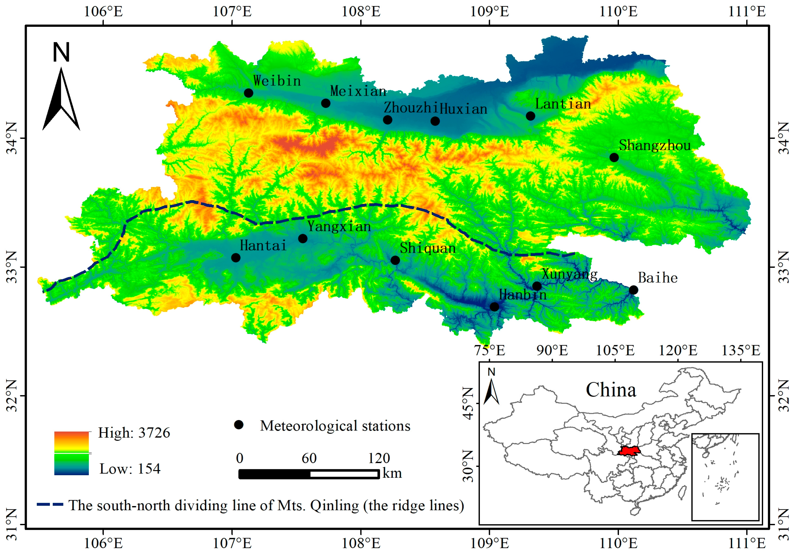
2.1. Study Area

The study area covers a series of ancient fold-fault mountains extending from east to west in Central China [26,27]. The highest peak, Mount Taibai, reaches an elevation of 3771.2 m. Mts. Qinling is widely recognized in China as a critical geographical divider [10], influencing not only regional ecological variances, production, and lifestyle between the North and South [28] but also serving as the demarcation line between the north subtropical zone and the warm temperate zone [29]. This boundary separates the humid regions to the North from the semi-humid regions in the South and includes the 800 mm annual precipitation isotherm and the mean January temperature 0 °C isotherm [30]. As a key geological and ecological transition zone in the Chinese Mainland, Mts. Qinling are characterized by its environmental complexity, biodiversity, and climate sensitivity. It significantly influences China’s geographical patterns, the evolution of biotic communities, and the distribution of natural resources [31,32,33]. Based on the divisions established by Chen Quangong’s research group regarding the Qinling–Huaihe line, the study region is bifurcated into northern and southern sections for comparative analysis, spanning Gansu Province, Shaanxi Province, and Henan Province, with a particular emphasis on Shaanxi Province [29,34]. The twelve meteorological stations utilized in this study are evenly distributed across the northern and southern parts of Shaanxi Province (see Table 1 and Figure 1 for detailed information).

2.2. Data Sources and Processing

The meteorological data utilized in this study were sourced from the National Meteorological Science Data Center (https://data.cma.cn/, accessed on 8 October 2023) and the Resource and Environmental Science Data Platform (http://www.resdc.cn, accessed on 8 October 2023). This dataset includes daily mean temperature, daily maximum temperature, and daily minimum temperature from 1971 to 2022 recorded at various meteorological stations throughout Mts. Qinling. These data effectively capture the climatic characteristics of the region. The dataset had a missing data rate of less than 5%. To enhance data quality and ensure accuracy, temperature records were scrutinized for outliers and errors using the R programming language. The evaluation was primarily based on the following standards: Firstly, it identified abnormal data characterized by temperature values significantly diverging from a reasonable climatic range. Secondly, it addressed evident entry errors, including duplicate data or extreme outliers. Thirdly, for extreme temperature data, historical data from meteorological stations and concurrent data from nearby stations were compared to validate the rationale for excluding outliers. Additionally, any missing data were imputed using the mean temperatures of the same day from the adjacent five years, thus preserving the consistency and reliability of the analysis. In terms of data processing, daily temperature data were statistically analyzed to compute multi-year average values across three temporal scales: inter-annual, inter-seasonal, and inter-monthly. For climatic analysis, the year was divided into four seasons: spring (March to May), summer (June to August), autumn (September to November), and winter (December to February of the following year).

2.3. Research Methods

2.3.1. Trend Analysis Method

In this study, the trend analysis method was employed to investigate temperature variations across three temporal scales: inter-annual, inter-seasonal, and inter-monthly [35,36]. This method involves modeling the relationship between a climate index, designated as xi, and time, ti, over a sample size, n. A linear regression model is constructed with xi as the dependent variable and ti as the independent variable:
x i ^ = a + b t i   i   =   1 ,   2 ,   ,   n ,   R 2 = c
where a represents a constant term, b denotes a trend coefficient, and c is a fitted value. A positive value of b (>0) indicates an upward trend in the variable, suggesting that it increases over time. Conversely, a negative value of b (<0) signifies a downward trend, indicating a decrease over time. The magnitude of b reflects the rate of increase or decrease: the larger the absolute value of b, the steeper the trend [37].
In this analysis, the coefficient b is multiplied by a factor of 10 to represent the linear trend rate of climate factors. Additionally, R2, the coefficient of determination, indicates how well the model fits the data. The value of c ranges from 0 to 1, with values closer to 1 signifying a higher degree of fit and, consequently, greater reliability of the model. A high c value indicates that the predicted values generated by the regression model align closely with the actual data, thus affirming the robustness of the trend line [38].

2.3.2. Mann–Kendall Mutation Test

The Mann–Kendall (M–K) mutation test is a diagnostic and forecasting technique endorsed by the World Meteorological Organization. It is extensively utilized as a non-parametric statistical method in climate studies. This method is particularly effective in detecting abrupt changes within a series of temperature data and identifying the timing of such changes. A significant advantage of the M–K test is its robustness. It does not require the data to adhere to a specific distribution and is resilient to the influence of outliers. Consequently, this method is highly versatile and has minimal requirements regarding the distribution characteristics of the data set [39,40,41,42].
To apply the M–K mutation test, begin by assuming a randomly independent time series x with a sample size of n. From this series, construct a rank series as follows:
s k = i = 1 k r i   ( k   =   2 ,   3 ,   ,   n )
where, when xi > xj, j = 1, 2, …, i, ri = 1; otherwise, ri = 0.
We can define the following statistic:
U F k = [ s k E ( s k ) ] V a r ( s k ) ( k   =   1 ,   2 ,   ,   n )
The UFk sequence adheres to a standard normal distribution, beginning with an initial condition where UF1 = 0. This condition holds true when the data points x1, x2, …, xn are identically distributed and independent of one another. It can be calculated as follows:
E s k = n ( n 1 ) 4
V a r s k = n ( n 1 ) ( 2 n + 5 ) 72
where E(sk) denotes the expected mean, and Var(sk) represents the variance of sk. Assuming a significance level of α = 0.05, the critical value μ0.05 = ±1.96. According to the principle of the M–K mutation test, when the sequence of the test statistic curve UF > 0, it implies an upward trend in the time series data. Conversely, if UF < 0, it indicates a downward trend in the data. When the UF value surpasses the critical bounds of ±1.96, it suggests a significant trend within the time series. If the intersection of UF and UB (backward test statistic) falls within the critical range of [−1.96, 1.96], the corresponding point in time is identified as the moment of an abrupt change. If the intersection falls outside this interval, the alterations in the time series data at that specific year are deemed not statistically significant. This indicates that no abrupt change has occurred.

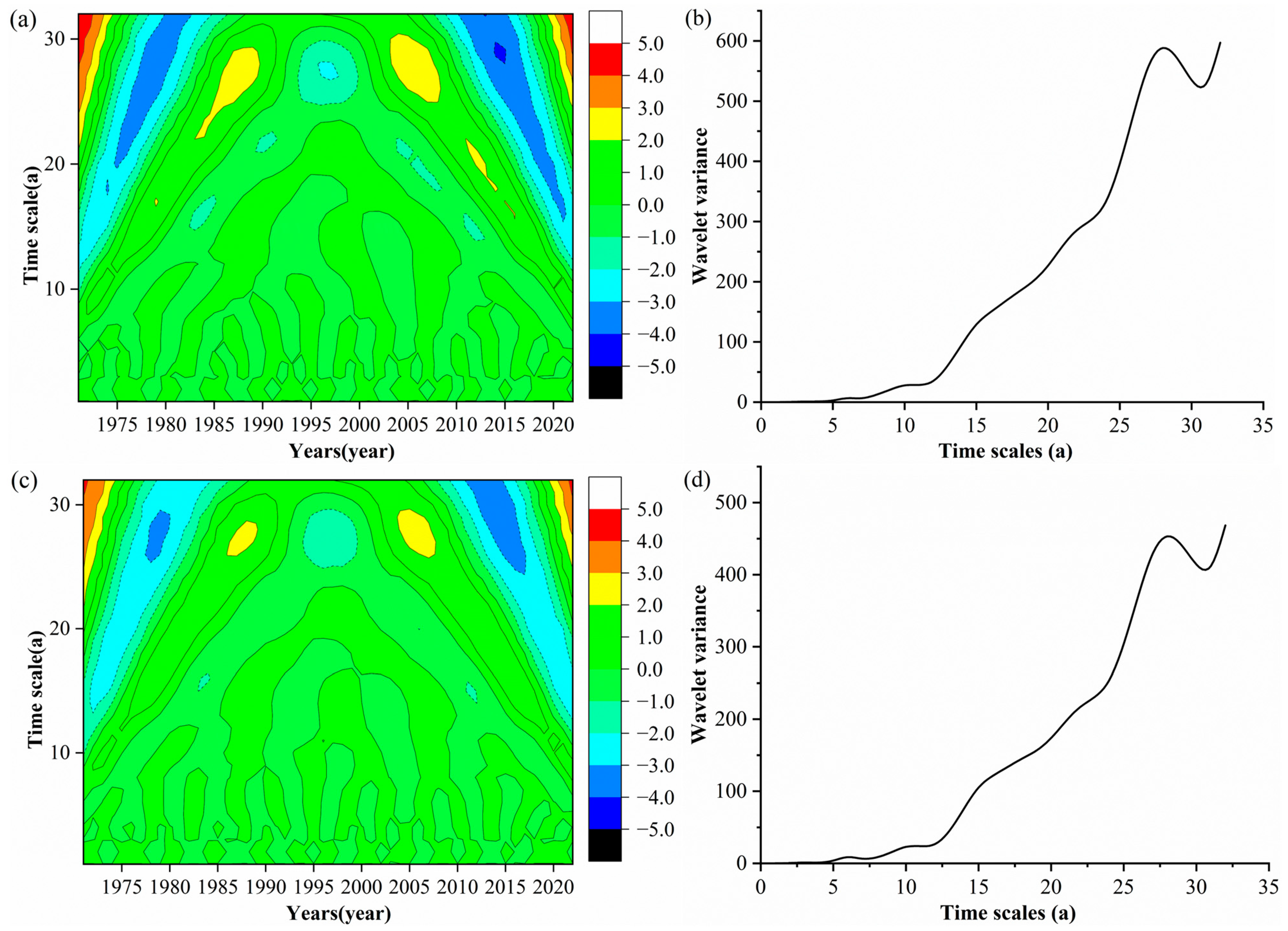
2.3.3. Morlet Wavelet Analysis

Morlet wavelet analysis involves the translation and scaling of a fundamental wavelet function. It uses a series of functions to represent or approximate signals. This technique boasts superior localization in both time and frequency domains. It is particularly effective for processing non-stationary data in image and signal analysis. Wavelet analysis is effective for detecting temperature cycles. The wavelet coefficient illustrates the local characteristics of the signal across various time scales, and its significance aids in assessing whether periodic oscillations at a particular time scale are statistically significant. This enables the identification of primary cycles in temperature data while mitigating the impact of random factors. Additionally, wavelet variance indicates the intensity or amplitude of temperature fluctuations over different periods. Higher wavelet variance signifies more pronounced periodic oscillations at that specific time scale. The real part of the wavelet analysis graphically depicts time–frequency variations in oscillation cycles at various scales. It provides invaluable insights into periodic temperature changes. Conversely, the wavelet variance plot illustrates the distribution of temperature fluctuations across time scales, highlighting the relative intensity of disturbances. The scale corresponding to the variance peak denotes the principal time scale, signifying the predominant periodicity in the time series [43,44,45,46]. In this study, the series for mean, maximum, and minimum temperatures were extended using the Signal Extension tool from the Wavelet Toolbox in MATLAB 2017b. Subsequently, these extended series were analyzed through a Morlet wavelet transform, specifically utilizing the ‘cmor’ wavelet function to explore their multi-time scale characteristics.
For the time series function f(t), the wavelet transform is presented as
W f a , b = 1 a φ * ( t b a ) d t
where Wf(a,b) represents the wavelet coefficient, a is the scaling factor, b is the translation factor, and φ represents the complex conjugate of φ*. The continuous wavelet transform applied to climate variables is expressed as
φ x = C e x 2 2 cos ( 5 x )
The wavelet variance is calculated as follows:
W p a = W f ( a , b ) 2
At a specific time scale, wavelet variance quantifies the strength of periodic fluctuations, providing a measure of variability within that scale of the time series. The peak of the wavelet variance plot indicates the scale at which these fluctuations are most pronounced, thereby establishing the principal time scale of the series. This principal time scale is significant as it corresponds to the dominant periodicity, highlighting the most persistent cyclic behavior in the data set.

3. Results and Analysis

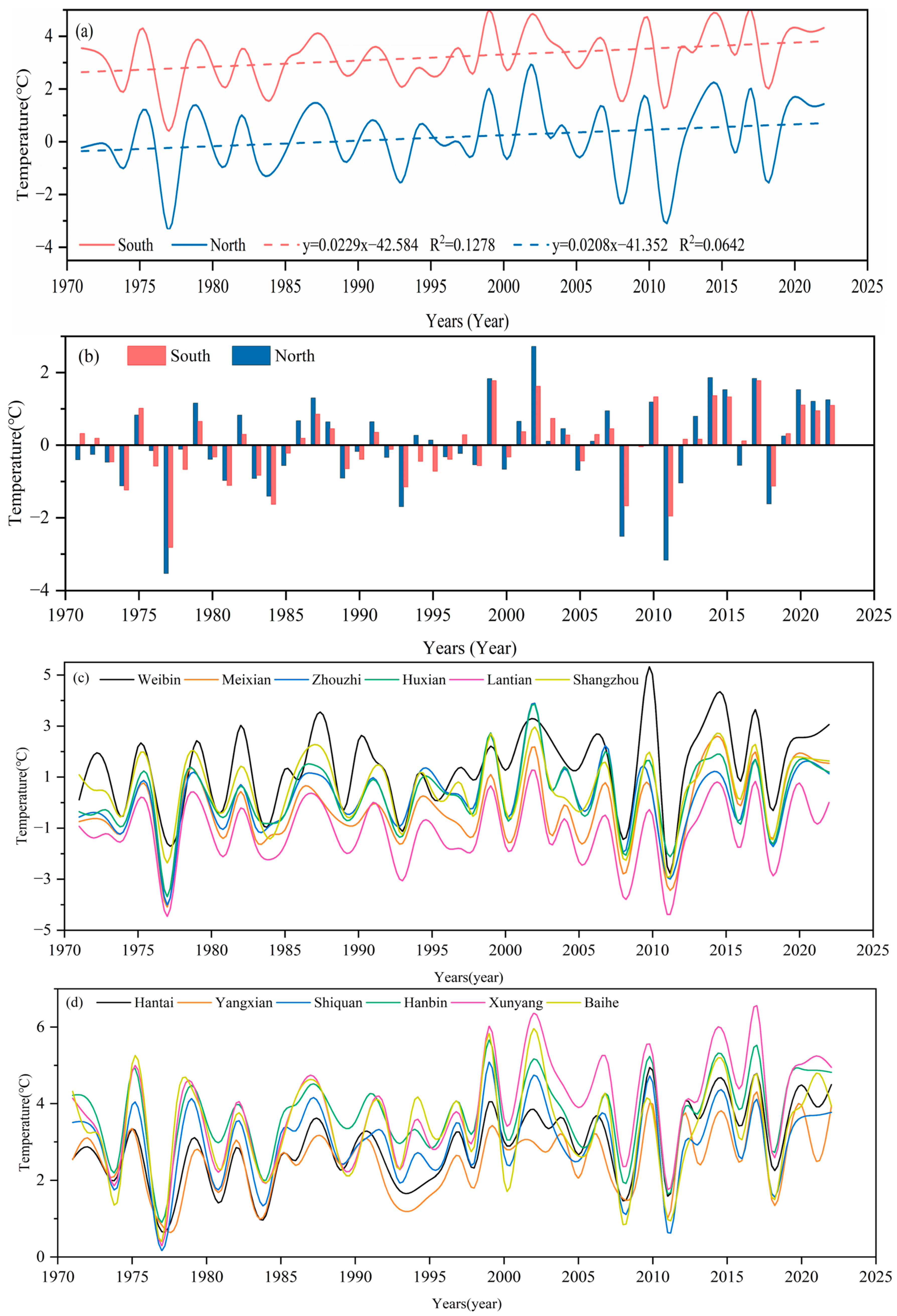
3.1. Temperature Change Based on Daily Mean Values

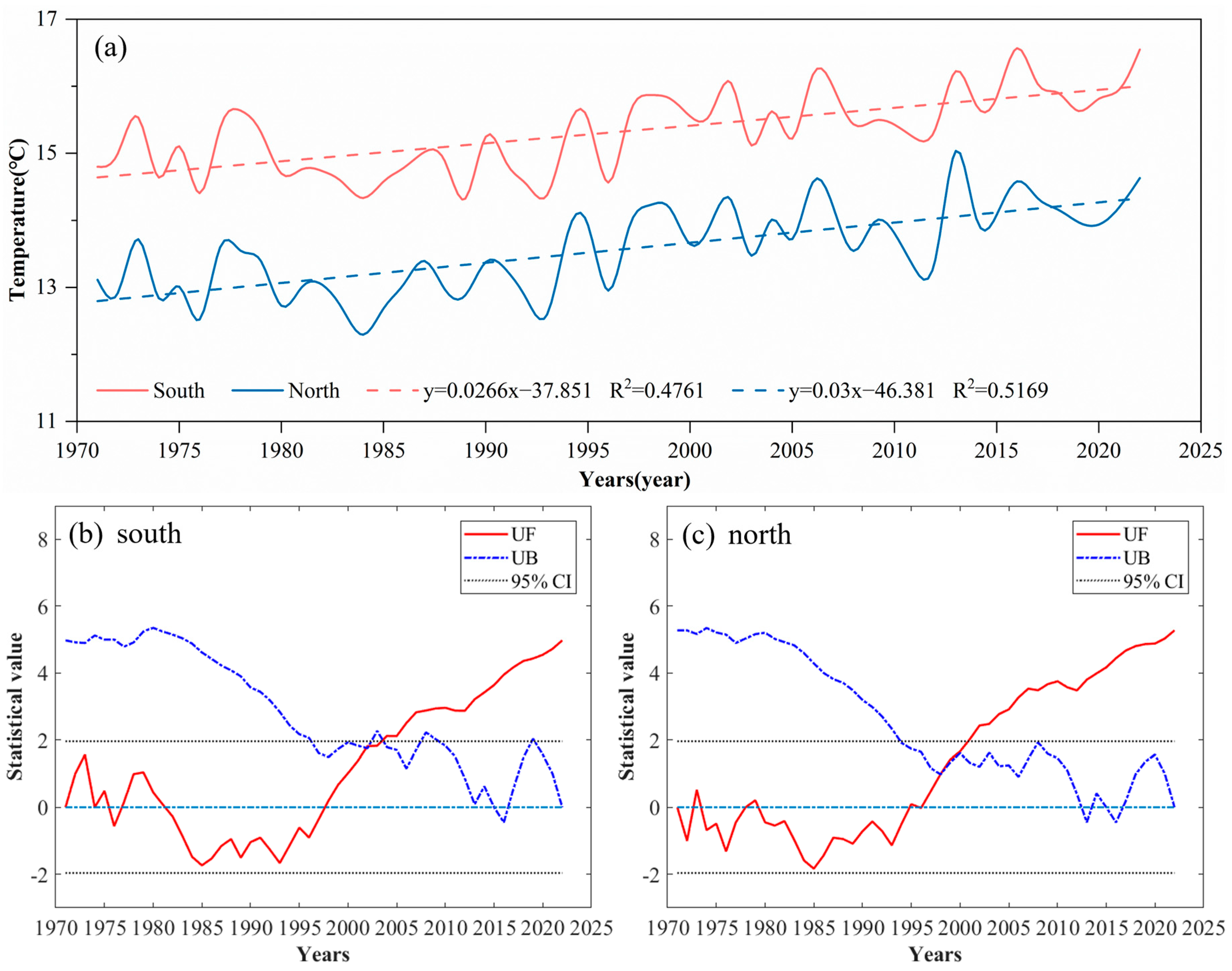
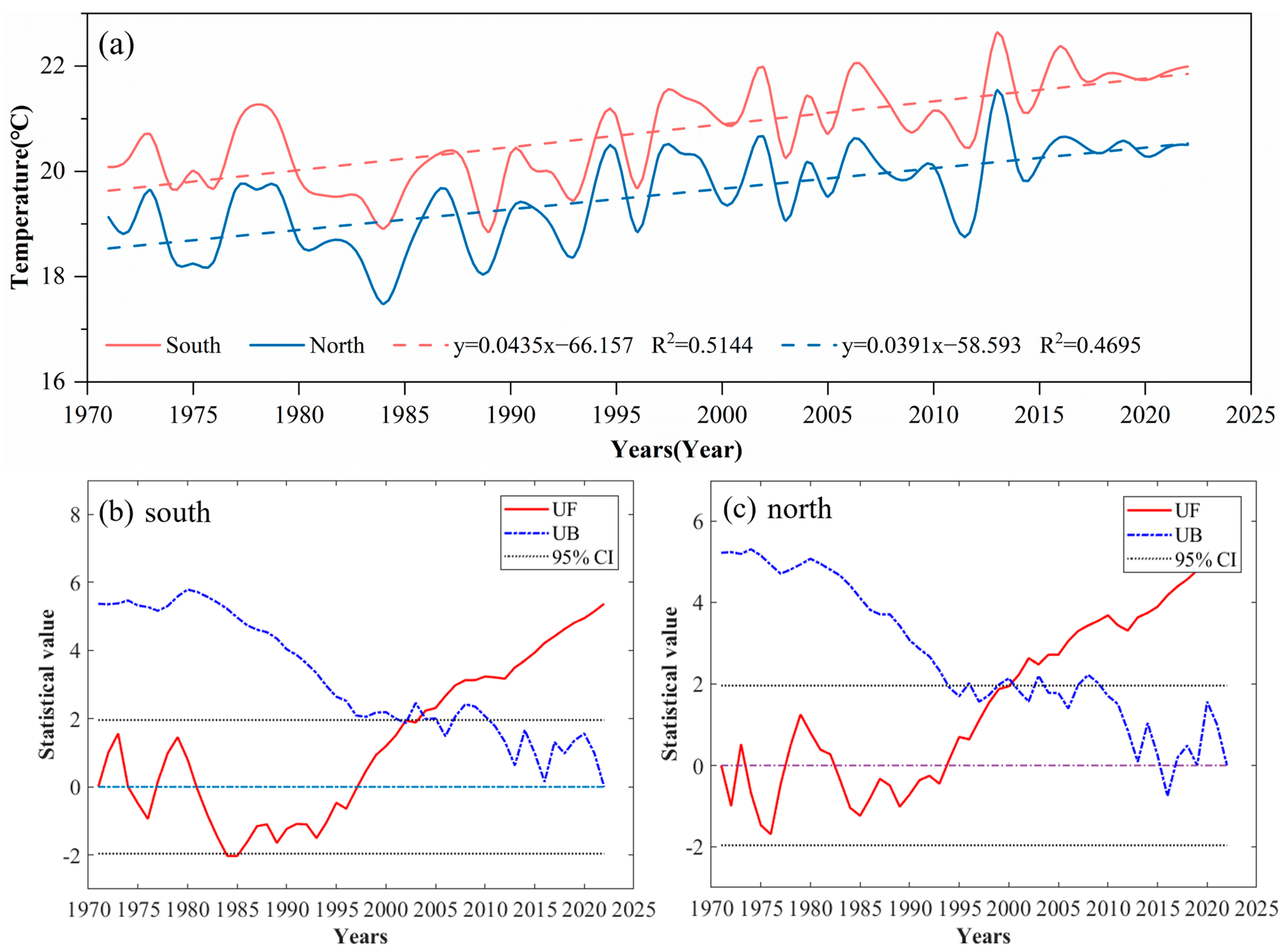
3.1.1. Inter-Annual Temperature Changes

The comparative analysis of the daily mean annual temperatures between the North and the South (Figure 2a) reveals distinct regional trends. The mean annual temperature in the South was recorded at 15.32 °C, with a warming trend of 0.266 °C/10a. The highest and lowest annual temperatures in the South were observed in 2016 and 1989, registering 16.57 °C and 14.32 °C, respectively, indicating a variability of 2.25 °C. In contrast, the northern region exhibited a mean annual temperature of 13.56 °C, with a slightly higher warming rate of 0.300 °C/10a. The highest and lowest temperatures in the North occurred in 2013 and 1984, at 15.04 °C and 12.29 °C, respectively, showing a greater range of 2.74 °C. Interestingly, both regions recorded their highest and lowest mean annual temperatures in the 2010s and 1980s, respectively. Furthermore, the average annual temperature in the South was consistently 1.76 °C higher than that in the North. However, the warming trend in the South was marginally slower by 0.034 °C/10a compared to the North, suggesting a narrowing temperature differential between the two regions. This pattern indicates a gradual weakening of the temperature boundary effect associated with the Mts. Qinling.
The trends in average temperatures on either side of the Mts. Qinling further illustrate the effects of climate change on the region. Subsequently, by utilizing the M–K mutation test method, we can perform a trend analysis and mutation assessment of average temperatures in the Qinling area, facilitating a more comprehensive understanding of the dynamic characteristics of temperature variation. Figure 2b,c reveal the temperature trends and abrupt changes in the Mts. Qinling region. In the southern part, a slight upward trend in mean temperature was observed before 1981, followed by a slight downward trend continuing until 1998. Post-1998, the upward trajectory resumed, with the UF curve consistently remaining above zero, indicating a continuous increase in mean temperature. A significant upward trend was confirmed in 2003 when the UF curve crossed the critical threshold within the confidence interval. The statistical values of the UF and UB curves intersected in 2002 within the critical lines, making 2002 a year of abrupt change in mean temperature.
Conversely, in the Northern Mts. Qinling, the UF curve mainly remained below zero until 1995, indicating a non-significant downward trend as it did not exceed the −1.96 threshold. Beginning in 1995, the mean temperature started to increase, and in 2001, it significantly crossed the critical line at the 0.05 significance level, indicating a marked upward trend. Importantly, the statistical values of UF and UB curves intersected in 1998 within the critical lines, identifying 1998 as a year of abrupt change in mean temperature.
In the analysis above, we can determine the dynamic characteristics of average temperature changes on either side of the Mts. Qinling. To further investigate the periodicity and oscillatory characteristics of mean temperature variations, we applied wavelet analysis to examine the oscillation cycles of mean temperatures in the Mts. Qinling over the past 52 years. Figure 3 visually illustrates the oscillation periods of the mean temperature in the Mts. Qinling over the past 52 years across various time scales. The magnitude of the wavelet coefficients shown in the figure indicates the strength of the temperature signal. Contour lines, solid when positive, denote higher temperatures, and they are dashed when negative, indicating lower temperatures. In both the southern and northern regions of the Mts. Qinling, the analysis revealed frequent temperature fluctuations within time scales shorter than 10 years, suggesting responsiveness to short-term climatic variations. Conversely, at longer time scales of 20 years and beyond, the data exhibited more pronounced trends and periodic changes indicative of long-term natural climatic cycles. Figure 3b,d highlight notable oscillations with a cycle of approximately 28 years in both foothills. Noteworthy phases include low temperatures centered around the years 1978 and 2013, contrasted with high-temperature peaks around 1985 and 2003. Additionally, the southern region demonstrated longer durations of warming and cooling trends compared to the northern region, indicating regional differences in climatic responses within the Mts. Qinling.

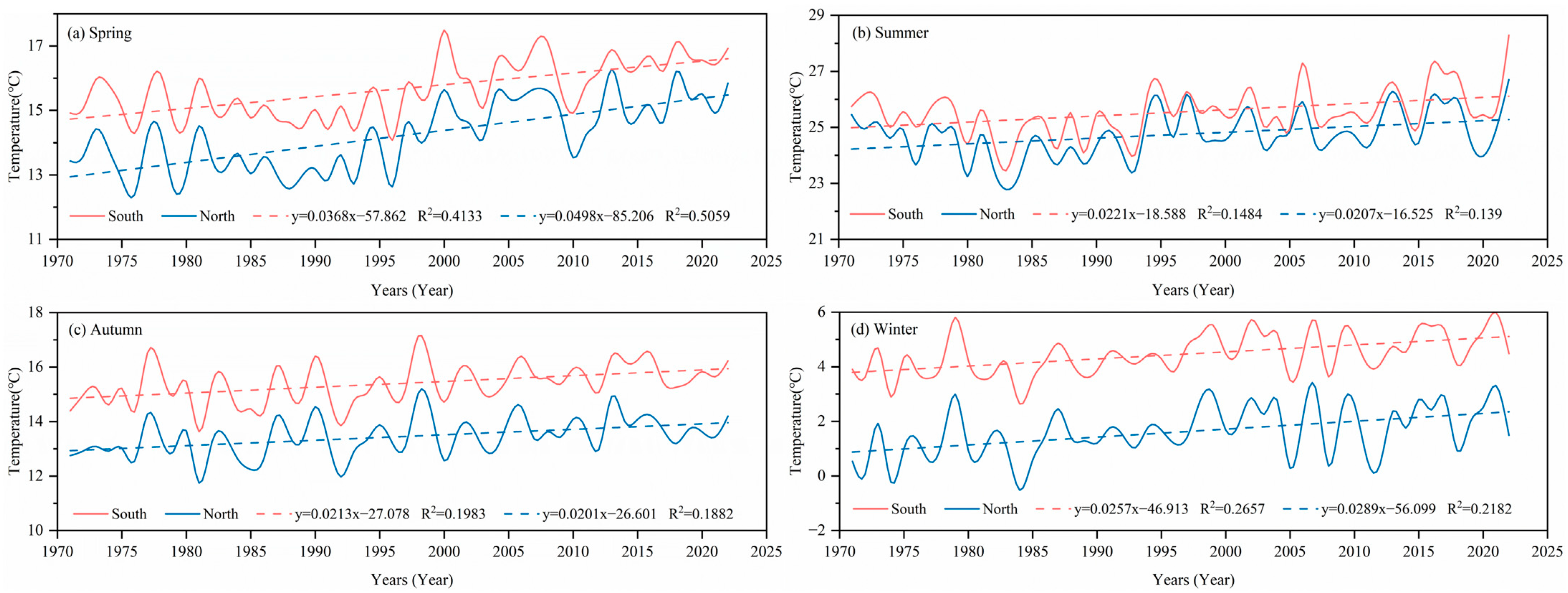
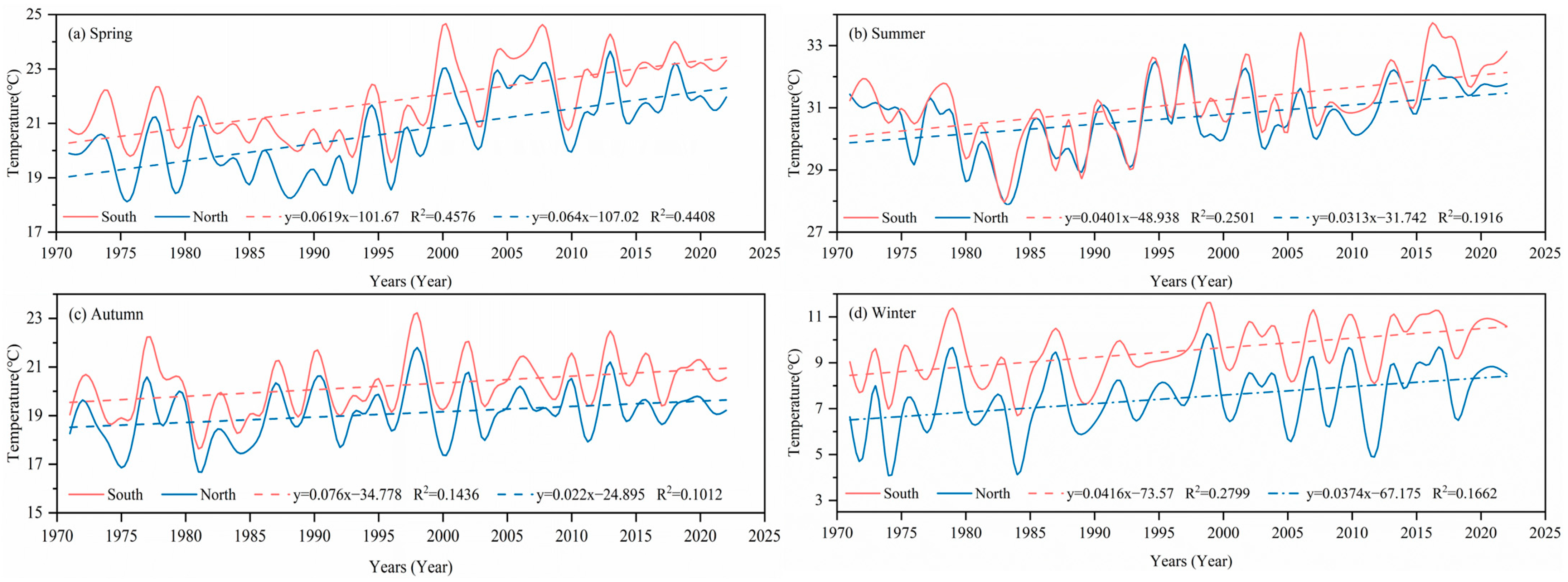
3.1.2. Inter-Seasonal Temperature Changes

The analysis of inter-seasonal temperature variations based on daily mean temperatures reveals three main differences between the spring–winter and summer–autumn seasons in the northern and southern regions of the Mts. Qinling, as illustrated in Figure 4. Firstly, the rates of temperature change in spring were the highest of all seasons, measuring 0.368 °C/10a in the South and 0.498 °C/10a in the North. Secondly, the rates of linear temperature change during winter also exhibited significant increases, ranking as the second highest annually at 0.257 °C/10a in the South and 0.289 °C/10a in the North. Thirdly, across both spring and winter, the North showed higher temperature change rates compared to the South. Conversely, the trend rates during the summer–autumn periods were lower than those in spring–winter. Notably, the trend rate of temperature change in the North was lower than that in the South during these warmer months.
In summary, temperatures rose in both the northern and southern regions of the Mts. Qinling throughout all seasons, with more significant increases observed during the spring and winter. Generally, the temperature change rates in the North were higher than those in the South, except during summer–autumn, where this pattern reversed. The observed trends, a weakening of the temperature boundary effect associated with the Mts. Qinling, are particularly highlighted by higher contribution rates in the spring–winter seasons compared to the summer–autumn.

3.1.3. Inter-Monthly Temperature Changes

Table 2 provides a detailed comparison of monthly temperature changes between the northern and southern regions of the Mts. Qinling based on daily temperature metrics that include daily mean, maximum, and minimum values. In the analysis of inter-monthly temperature changes based on daily mean temperatures, three key conclusions can be derived: First of all, temperature variations exhibited a warming trend throughout all months, indicating a significant regional warming effect across the Mts. Qinling. Secondly, the trend rates of temperature change were higher in the North than in the South during seven specific months: February, March, April, May, June, November, and December. Conversely, during the remaining five months, the South demonstrated higher temperature change rates than the North. This pattern suggests that the North generally experiences a slightly more intense warming trend for most of the year. Thirdly, among the 24 trend rates across all 12 months, 7 rates exceeded 0.3 °C/10a, occurring specifically in February, March, April, and May. These findings indicate that spring contributes most significantly to the annual warming trend. Additionally, the greater increase in temperatures in the North compared to the South during these months suggests a weakening influence of the temperature-boundary effect traditionally associated with the Mts. Qinling.

3.1.4. Analysis of the 0 °C Isotherm in January for Mts. Qinling

It is widely acknowledged that the Mts. Qinling act as the geographical demarcation for the 0 °C January isotherm between Northern and Southern Chinese Mainland. The analysis of temperature changes from 1971 to 2022 yielded three critical insights: Firstly, there was a distinct warming trend in January’s annual temperatures, with the southern region experiencing a slightly higher rate of increase, at 0.229 °C/10a, compared to 0.208 °C/10a in the North (Figure 5a). This indicates a more pronounced warming trend in the South. Secondly, the year 1998 marks a turning point; before this year, the temperature growth rate was slower, and the fluctuations were more moderate. After 1998, both the growth rate and temperature fluctuations intensified, with the North showing more significant variability than the South (Figure 5b). Thirdly, in January, all six meteorological stations in the South consistently recorded temperatures above 0 °C, with rarely any temperatures falling below 1 °C (Figure 5c). In contrast, temperatures at the northern stations seldom rose above 1 °C, typically fluctuating around 0 °C. Notably, the Lantian Station in the North recorded a mean annual temperature above 1 °C only once in the last 52 years, in 2002 (Figure 5d). These findings raise questions about the continued characterization of the Mts. Qinling as the definitive 0 °C January isotherm separating the North and South Chinese Mainland.
In summary, the analysis of January’s mean temperature changes between the North and South Chinese Mainland, based on daily mean temperature data from 1971 to 2022, suggests that describing the Mts. Qinling as the 1 °C isotherm in January might be more accurate, particularly in light of the intensifying global warming trend. This perspective aligns with the results found by Zhang et al. [21], suggesting that the north subtropical transitional zone of the Mts. Qinling may be transitioning fully or partially into a subtropical zone due to warming conditions.
In summary, an analysis of daily mean temperature variations in the North and South regions yields four key conclusions. Firstly, a clear regional warming trend is evident across all months. Secondly, the rate of temperature change is significantly higher during the spring–winter seasons and lower during the summer–autumn, with the North generally experiencing more significant changes than the South throughout most of the year. Thirdly, the temperature-boundary effect associated with the Mts. Qinling shows signs of weakening, with a greater contribution rate observed during the spring–winter than in the summer–autumn. Lastly, considering the intensifying global warming trends, the assertion that ‘Mts. Qinling is evolving into the 1 °C January isotherm between the north and the south of the Chinese Mainland’ appears increasingly plausible.

3.2. Temperature Change Based on Daily Maximum Values

3.2.1. Inter-Annual Temperature Changes

The analysis of the daily maximum temperature over a 52-year period, as illustrated in Figure 6a, reveals significant inter-annual variations. In the South, the average maximum temperature was 20.74 °C, with a linear trend rate of 0.435 °C/10a. The highest recorded temperature was 22.64 °C in 2013, while the lowest was 18.86 °C in 1989, yielding a range of 3.78 °C. In comparison, the northern region’s average maximum temperature was 18.63 °C, with a trend rate of 0.391 °C/10a. The highest and lowest temperatures in the North were 20.65 °C in 2013 and 16.58 °C in 1984, respectively, resulting in a slightly larger range of 4.07 °C. Consistent with the trends observed in daily mean temperatures, the highest and lowest temperatures for both regions occurred in the decades of the 2010s and 1980s. Moreover, the southern region’s temperatures were, on average, 2.11 °C higher than those in the North, with a trend rate that was 0.044 °C/10a. This indicates a slight increase in the temperature differential between the two regions. Therefore, the analysis of daily maximum temperatures indicates a more pronounced climatic-boundary effect of the Mts. Qinling compared to that derived from mean temperature data.
After examining the changes in daily maximum temperatures in the Qinling region, we can further explore the trends and fluctuation characteristics of maximum temperatures across various time periods. Figure 6b reveals the fluctuations in the UF statistics for the South Mts. Qinling before 1981, where the UF statistic oscillated around the zero line. This suggests significant variability in maximum temperatures without any significant long-term upward or downward trend. From 1981 to 1998, the UF curve predominantly remained below zero but did not exceed the −1.96 threshold, suggesting a non-significant downward trend in maximum temperatures during these 17 years. In the subsequent period from 1998 to 2003, the UF curve rose above zero, hinting at a slight upward trend in maximum temperatures, which became significant in 2003 when the UF value crossed the critical line of the confidence interval. Conversely, Figure 6c illustrates the temperature trends in the North Mts. Qinling. Before 1978, the UF statistic generally fluctuated between −1.96 and 0, suggesting a slight downward trend in maximum temperatures. Between 1978 and 1983, a slight upward trend was observed. However, from 1983 to 1995, the UF statistic once again stayed below zero without exceeding the −1.96 mark, indicating a weak downward trend. Post-1995, the maximum temperatures began to exhibit a marked upward trend, reaching statistical significance in 2002. Notably, since the intersection points of the UF and UB curves for maximum temperatures in both the North and South have not fallen within the [−1.96, +1.96] statistical range, it can be concluded that there have been no abrupt changes in maximum temperatures over the past 52 years.
Based on the analysis of trend changes in maximum temperatures on either side of Mts. Qinling, we can further investigate the periodic characteristics of their time series. Figure 7 illustrates that the time series of maximum temperatures for both the southern and northern regions of the Mts. Qinling, over the past 52 years, exhibited two prominent peaks occurring at the 10-year and 28-year time scales. The more prominent peak at the 28-year scale indicates the strongest oscillation energy within this cycle, establishing it as the primary periodicity for maximum temperature changes in Mts. Qinling during this period. The secondary peak at the 10-year scale also plays a critical role in controlling the characteristics of maximum temperature fluctuations in the region from 1971 to 2022. In the South Mts. Qinling, maximum temperatures showed a long-term periodic pattern typically ranging between 16 and 32 years, denoting oscillations between warming and cooling phases within this timeframe. In contrast, the North showed a slightly shorter periodic range from 20 to 32 years for maximum temperatures, suggesting that temperature oscillations occur over a comparably narrower timescale than in the South. For both regions, the midpoint of these oscillations is approximately at the 28-year mark, affirming the central role of this cycle in shaping the thermal dynamics of Mts. Qinling.

3.2.2. Inter-Seasonal Temperature Changes

Figure 8, which utilized daily maximum temperature data, illustrates the average temperature variations across the four seasons in both the northern and southern regions of the Mts. Qinling. The overall pattern mirrored that observed with daily mean temperature variations, particularly highlighting a stark contrast between spring–winter and summer–autumn. Notably, the highest temperature change rates occurred in spring, with the North experiencing a slightly higher rate of 0.640 °C/10a compared to 0.619 °C/10a in the South. Winter followed, displaying the second-highest change rates at 0.374 ℃/10a in the North and 0.416 °C/10a in the South. In contrast, the temperature increase rates during the summer–autumn seasons were significantly lower in both regions. Specifically, during spring, the North consistently exhibited higher warming rates than the South. Overall, temperatures were rising in all four seasons across both the South and North Mts. Qinling. However, the South demonstrated a higher rate of temperature increase during the summer, autumn, and winter compared to the North. This trend reinforces the observations from earlier sections (as seen in Figure 6a) and helps clarify the growing temperature disparity between the two sides of Mts. Qinling.

3.2.3. Inter-Monthly Temperature Changes

An analysis of the monthly variation characteristics of air temperature between the South and North Mts. Qinling, based on daily maximum values from Table 2, yields three main conclusions. Firstly, a warming trend was evident across all months, indicating a significant regional warming effect. Secondly, the southern region generally experienced stronger temperature increases than the North, as evidenced by higher trend rates of temperature change in nine out of twelve months, with the exceptions being February, May, and November. Finally, among the 24 trend rates evaluated throughout the year, 7 exceeded 0.45 °C/10a, with 6 of these occurring during February, March, April, and May, highlighting spring as the primary contributor to the observed warming observed in the region.
In summary, the analysis of temperature characteristics in the northern and southern regions of the Mts. Qinling, based on maximum daily values, reveals three main insights. Firstly, a warming trend is evident across both regions. However, it is less pronounced in the North compared to the South for most of the year. Secondly, spring exhibits the highest contribution rate to regional warming among all seasons, with the North experiencing a higher trend rate of temperature change than the South during this period. Thirdly, the data suggest an enhancement effect on the climatic boundary of the Mts. Qinling.

3.3. Temperature Change Based on Daily Minimum Values

3.3.1. Inter-Annual Temperature Changes

An analysis of the daily minimum temperature variation over 52 years in the Mts. Qinling, as presented in Figure 9a, reveals distinct climatic patterns between the North and South. In the southern region, the average temperature recorded over the period was 11.42 °C, with a temperature increase rate of 0.268 °C/10a. The highest and lowest temperatures were 12.48 °C in 2016 and 10.43 °C in 1992, respectively, demonstrating a range of 2.05 °C. In contrast, the northern region had an average temperature of 8.96 °C, with a slightly higher increase rate of 0.322 °C/10a. Here, the temperature peaked at 10.21 °C in 2013 and dipped to 8.01 °C in 1972, resulting in a variance of 2.20 °C. Comparatively, the average temperature in the South was 2.46 °C higher than in the North, though the rate of temperature increase was 0.054 °C/10a slower. This indicates that the average temperature difference between the northern and southern sides of Mts. Qinling is narrowing. Consistent with the patterns observed in daily mean temperature data, the temperature-boundary effect of the mountains also showed a weakening trend according to these findings.
After examining the trends in daily minimum temperatures in the South and North Mts. Qinling, it is essential to further analyze their significance and mutation characteristics. Figure 9b illustrates distinct phases in the trends of minimum temperatures in the South Mts. Qinling over the past 52 years. Before 1984, the UF curve oscillated in the range of [0, +1.96], indicating a gradual yet statistically insignificant increase in minimum temperatures. From 1984 to 1998, the UF curve fell within the [−1.96, 0] range, suggesting a minor downward trend in temperatures during this period. However, starting in 1998, the UF curve consistently remained above zero and crossed the +1.96 threshold by 2002, marking a significant upward trend in minimum temperatures. Notably, the lack of intersection points between the UF and UB curves within the [−1.96, +1.96] range throughout this period indicates that there are no abrupt changes in the minimum temperatures in the southern region of Mts. Qinling over the observed timeframe.
Figure 9c provides insight into the trends in minimum temperatures in the North of Mts. Qinling from 1971 onwards. Between 1971 and 1989, the UF curve predominantly fluctuated around the zero line, indicating the absence of a definitive trend during this period. The temperature changes during these years were minor and lacked stability, suggesting fluctuating but generally static temperature conditions. From 1989 to 2000, the UF values were contained within the [0, +1.96] range. This pattern points to a slight upward trend in minimum temperatures across these 11 years, suggesting a gradual warming phase. After 2000, the trend in minimum temperatures began to intensify, displaying a clear and significant upward trajectory. A key observation from the graph is the intersection of the UF and UB curves within the 0.05 confidence interval around 1998. This intersection suggests that 1998 could be regarded as a preliminary year marking the onset of an abrupt change in the minimum temperatures in the region.
After assessing the characteristics of minimum temperature changes on either side of the Mts. Qinling, it is equally important to conduct a further examination of their periodic fluctuations across various time scales. Figure 10 presents the real part of the Morlet wavelet change coefficient contour maps along with variance plots for minimum temperatures in the Mts. Qinling, capturing data over the past 52 years. The diagrams distinctly highlight the main peaks of wavelet variance at the 28-year time scale for both the southern and northern foothills, establishing 28 years as the primary periodicity for temperature fluctuations in these regions. In the southern part of the Mts. Qinling, the wavelet analysis identified a higher temperature center in 2005, followed by a lower temperature center in 2015. In contrast, in the northern region, two notably lower temperature centers were detected, occurring in 1980 and 2015.

3.3.2. Inter-Seasonal Temperature Changes

Figure 11 provides an analysis of the seasonal mean temperature variations between the South and North Mts. Qinling, utilizing daily minimum temperature data. Two significant findings emerged from this comparison. Firstly, the spring season demonstrated the highest trend rates of temperature change, recorded at 0.285 °C/10a in the South and 0.446 °C/10a in the North. Secondly, the trend rate of temperature change throughout the year was consistently higher in the North compared to the South. This observation reinforces the earlier conclusion that the temperature-boundary effect of Mts. Qinling is weakening, as indicated by the more pronounced warming trends in the northern region.

3.3.3. Inter-Monthly Temperature Changes

An analysis of the monthly temperature changes between the South and North Mts. Qinling, based on daily minimum values, as shown in Table 2, reveals three distinct characteristics. Firstly, a warming trend was evident across all months, reflecting a significant regional response to global warming. Secondly, the temperature increase rates in the North exceeded those in the South for most months, with the exceptions of January, October, and November. This pattern contrasts with the findings based on daily maximum temperature values but aligns more closely with, and is slightly stronger than, the trends observed in the daily mean temperature data. Lastly, out of the 24 trend rates across the 12 months, 6 rates exceeded 0.37 °C/10a, with 5 of these high rates occurring in February, March, April, and May. This suggests that spring contributes most significantly to global warming, confirming findings from both daily mean and maximum temperature analyses.
In summary, the analysis of daily minimum temperature variations emphasizes three key points. Firstly, there is a pronounced regional warming trend across all months. Secondly, spring exhibits the highest contribution rate to warming, suggesting its significant role in regional temperature increases. Lastly, there is a noticeable weakening in the temperature-boundary effect of the Mts. Qinling, indicating a diminishing distinction between the northern and southern temperature gradients.

4. Discussion

This study offers a comprehensive analysis of multi-year temperature data from both the southern and northern regions of the Mts. Qinling, revealing a significant upward trend mirroring global warming patterns. The temperature rise is consistently observed across inter-annual, inter-seasonal, and inter-monthly variations, notably increasing minimum temperatures. This warming may significantly influence the phenological stages of local plant and agricultural cycles. For instance, while elevated temperatures might extend the vegetation growth period and accelerate nutrient release from soil organic decomposition, they also risk exacerbating water shortages, thus potentially hindering vegetation growth in the face of insufficient rainfall [30,47,48]. The diminishing temperature-boundary effect and the northward movement of isotherms in the Qinling region may result in alterations in species distribution, leading to a decline in biodiversity and heightened competition among species. Existing habitats could be jeopardized, disrupting ecological balance. Furthermore, agricultural production models will require adjustment to address changing climatic conditions and maintain food security. Concurrently, the availability and management of water resources will encounter challenges, necessitating a re-evaluation of water-allocation and -usage strategies to adapt to the emerging climate patterns. Interestingly, the rate of temperature increase is generally higher in the North than in the South, likely due to the North’s proximity to the temperate zone and its heightened susceptibility to atmospheric circulation patterns. The ongoing intensification of the Western Pacific Subtropical High and the South Asian High serves as the primary circulation system to explain this phenomenon [49]. Additionally, more pronounced mountain barrier effects observed during spring and winter could be linked to decreased atmospheric stability, facilitating more frequent mountain airflow exchanges. Both regions of the Mts. Qinling are characterized by a primary temperature cycle of 28 years, indicative of significant long-period fluctuations potentially connected to broader climatic oscillations, such as the El Niño-Southern Oscillation (ENSO) and the Arctic Oscillation. Understanding these patterns is vital for predicting future climatic conditions within the region. The observable temperature changes in the Mts. Qinling result from a combination of natural factors and human activities [26]. Key influences include human-induced changes, solar radiation, atmospheric aerosols, and ocean temperatures [50,51]. Human activities have profoundly modified land use and climate patterns, contributing to regional temperature increases. For instance, the urban-heat-island effect results in substantially higher temperatures in urban areas compared to rural regions. Additionally, variations in solar radiation directly impact surface temperature and climate patterns. Increased radiation enhances the heat absorbed by the surface, leading to rising temperatures. This study highlights the importance of exploring temperature patterns across different scales and comprehending their implications for human habitation and adaptive strategies in response to climate change. Addressing these issues is imperative for advancing current climate change research and formulating effective environmental policies and strategies.
This study highlights the complexity of temperature fluctuations across the South and North Mts. Qinling while recognizing several limitations: Firstly, the analysis relied on data from twelve meteorological stations distributed across the region. Given the diverse elevations and varied landscapes of the Mts. Qinling, this station distribution might not fully capture the microclimatic variations due to the area’s complex topography. Secondly, while this study considered several influencing factors, such as geographical location and seasonal changes, it did not encompass all potential climatic drivers. Factors like atmospheric pollutants, changes in local vegetation, and human activities could significantly impact temperature dynamics. Thirdly, although wavelet analysis was employed to investigate periodic temperature changes, this study did not utilize climate models to predict future climatic trends. Utilizing climate models could enhance our understanding of long-term climate impacts on ecosystems and human activities. Lastly, the research predominantly concentrated on local climate data without adequately considering how global climate change could influence regional climate patterns. Future studies should focus more on global climatic factors, such as global temperature increases and alterations in ocean–atmosphere interactions, to provide a more comprehensive understanding of their impacts on regional climates.
Despite these limitations, this investigation into the temperature trends and patterns in the Mts. Qinling provides valuable scientific insights, establishing a foundational understanding of the region’s temperature dynamics. The results not only offer scientific evidence supporting the theoretical delineation between Northern and Southern China but also serve as a theoretical basis for a holistic understanding of the coordinated development between the region’s ecological environments and socio-economic systems. Specifically, the increasing temperatures and their effects on biodiversity, agricultural production, and water resource management highlight the pressing need for adaptive strategies. A more thorough understanding of these shifts will enable the creation of more focused climate adaptation policies, promoting the sustainable use of resources and maintaining ecosystem stability.
Additionally, this research assists in optimizing spatial planning, forecasting climate change trends, and developing effective disaster-prevention and -mitigation strategies. These contributions are essential for achieving China’s ‘dual carbon’ objectives and enhancing global climate governance. Future studies should address these limitations by adopting a wider range of methodologies, expanding data-collection efforts, and refining model analyses to yield more comprehensive and precise outcomes.

5. Conclusions

This study utilized daily atmospheric temperature data from twelve meteorological stations in Shaanxi Province from 1971 to 2022 to examine temperature variations between the northern and southern regions of the Mts. Qinling across annual, seasonal, and monthly scales. The key findings are summarized in six main aspects:
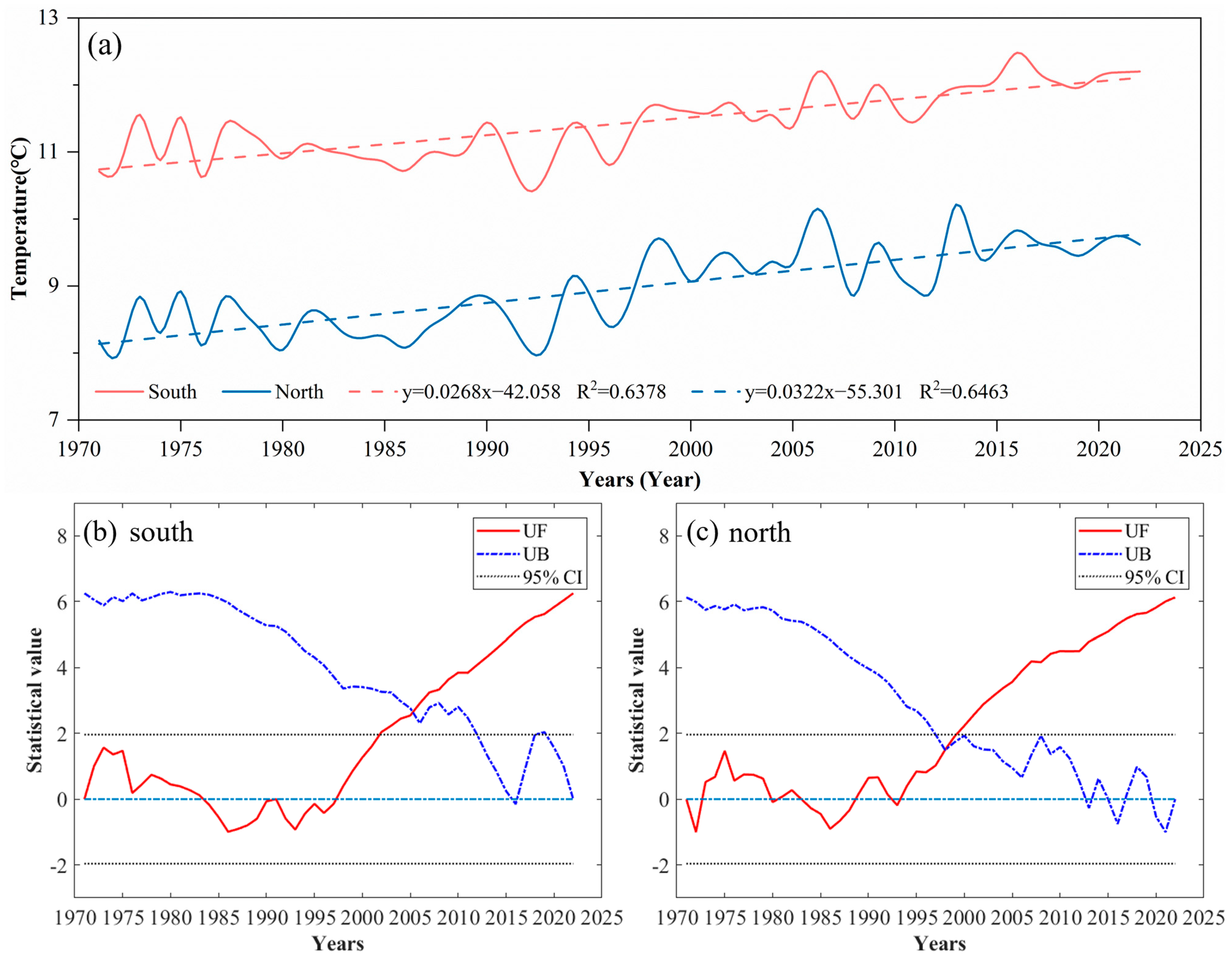
  • Based on the daily mean temperatures, the mean annual temperature in the North exhibited a higher variation tendency rate than that in the South. The southern slope experienced a significant change in 2002, while the northern slope underwent a mutation in 1998. Seasonally, temperature trend rates were higher in spring and winter in the North, while they were lower in summer and autumn. This indicates that temperature increases in spring and winter significantly weaken the boundary mountain effect, particularly in spring. Future research could investigate how alterations in the watershed effect influence regional biodiversity and ecological balance.
  • In the southern regions, the variation tendency rates of average temperature based on the daily maximum temperatures were consistently higher than in the North, except during spring. The warming effects in spring and winter were more pronounced, whereas fluctuations were more significant in summer and autumn.
  • The trend rates for average temperatures based on daily minimums were higher in the North, with another abrupt change noted in 1998. Spring exhibited the highest trend rates in both regions, highlighting its major contribution to regional warming.
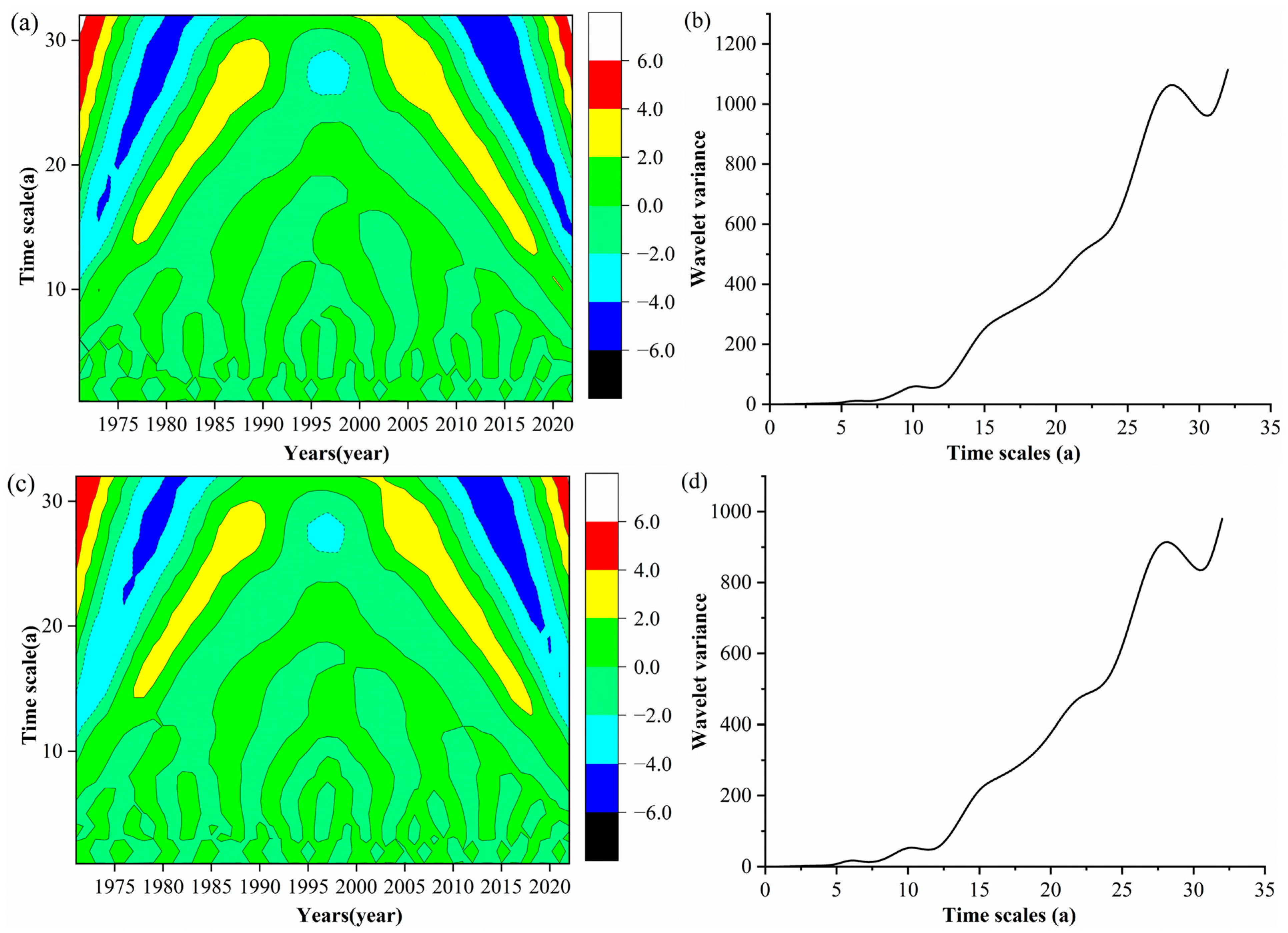
  • The periodic changes in daily mean, maximum, and minimum temperatures were generally similar across both regions, with a primary periodicity of 28 years. The cycle of temperature oscillations between warm and cold phases was longer in the South than in the North. In-depth research on this periodic variation will enhance our understanding of the long-term effects of climate change on regional climate patterns.
  • The temperature-boundary effect was predominantly observed at lower temperatures, with spring being the most affected season. As global climate change intensifies, the mountain effect is expected to strengthen in the North and weaken in the South. Future studies could examine how changes in minimum temperatures affect soil and aquatic ecosystems, particularly in spring.
  • After 1998, both regions experienced stronger warming trends in January, with greater fluctuation ranges than previously observed. Given the ongoing global warming trend, Mts. Qinling is projected to soon become the dividing line of the 1 °C isotherm in January between the northern and southern parts of the Chinese Mainland, replacing the current 0 °C isotherm. Future studies could investigate the impact of changes in minimum temperatures on soil and aquatic ecosystems, especially in spring.

Author Contributions

Conceptualization, C.H.; Investigation, C.H.; Resources, C.H.; Writing—Original Draft, C.H.; Supervision, C.H.; Project Administration, C.H.; Funding Acquisition, C.H.; Methodology, S.H.; Software, S.H.; Validation, S.H.; Formal Analysis, S.H.; Data Curation, S.H.; Writing—Review and Editing, S.H.; Visualization, S.H. All authors have read and agreed to the published version of the manuscript.

Funding

This research was funded by the National Natural Science Foundation of China (Project No. 42471130).

Institutional Review Board Statement

Not applicable.

Informed Consent Statement

Not applicable.

Data Availability Statement

Data will be made available on request.

Acknowledgments

The authors sincerely thank all persons and institutions who supported this work by providing data.

Conflicts of Interest

The authors declare no conflicts of interest.

References

  1. Li, B.Y.; Liu, D.W.; Yu, E.T.; Wang, L.X. Warming-and-wetting trend over China’s drylands: Observational evidence and future projection. Glob. Environ. Chang. 2024, 86, 102826. [Google Scholar] [CrossRef]
  2. Wang, S.R.; Zhang, Z.Q. Effects of climate change on water resources in China. Clim. Res. 2011, 47, 77–82. [Google Scholar] [CrossRef]
  3. Chen, Y.Y.; Ding, Y.J.; She, Z.X.; Lin, E.D. Climate and Environment Changes in China (Volume II: The Impacts, Adapting and Mitigating of Climate and Environmental Change in China); Science Press: Beijing, China, 2005. (In Chinese) [Google Scholar]
  4. Qian, W.H. Global Climate System; Peking University Press: Beijing, China, 2009. (In Chinese) [Google Scholar]
  5. IPCC. Meeting Report of the Intergovernmental Panel on Climate Change Expert Meeting on Climate Change, Food, and Agriculture; World Meteorological Organization: Geneva, Switzerland, 2015. [Google Scholar]
  6. Han, Y.; Zhao, G.Y.; Wang, Y.M.; Pan, X.L.; Jiang, L.L.; Xiang, M. New opinion about temperature rising for the recent 150 years. J. Xinyang Normal Univ. (Nat. Sci.) 2016, 29, 67–70. (In Chinese) [Google Scholar]
  7. Li, F.M.; Yin, S.Y.; Yin, T.Y. The spatial-temporal variations of extreme temperatures in the Qinling Daba Mountains and adjacent areas during 1960–2017. Acta Sci. Nat. Univ. Sunyatseni 2020, 59, 80–92. (In Chinese) [Google Scholar]
  8. Jia, L.; Zeng, B.; Yang, T.B.; Liu, K.Q. Temperature and precipitation changes in the Chinese monsoon region during the recent half century and the spatio-temporal differences thereof. J. Lanzhou Univ. (Nat. Sci.) 2015, 51, 186–192+201. (In Chinese) [Google Scholar]
  9. Yan, Z.W.; Ding, Y.H.; Zhai, P.M.; Song, L.C.; Cao, L.J.; Li, Z. Re-assessing climatic warming in China since the last century. Acta Meteor. Sin. 2020, 78, 370–378. (In Chinese) [Google Scholar]
  10. Liu, N.; Liu, Y.; Zhou, Q.; Bao, G. Droughts and broad-scale climate variability reflected by temperature-sensitive tree growth in the Qinling Mountains, central China. Int. J. Biometeorol. 2013, 57, 169–177. [Google Scholar] [CrossRef]
  11. Deng, C.H.; Bai, H.Y.; Ma, X.P.; Zhao, T.; Gao, S.; Huang, X.Y. Spatiotemporal differences in the climatic growing season in the Qinling Mountains of China under the influence of global warming from 1964 to 2015. Theor. Appl. Climatol. 2019, 138, 1899–1911. [Google Scholar] [CrossRef]
  12. Hu, Y.F.; Yao, Y.H.; Kou, Z.X. Exploring on the climate regionalization of Qinling-Daba mountains based on Geodetector-SVM model. PLoS ONE 2020, 16, e246774. [Google Scholar] [CrossRef]
  13. Wang, T.; Yang, M.H.; Yan, S.J.; Geng, G.P.; Li, Q.H.; Wang, F. Effects of temperature and precipitation on spatiotemporal variations of Net primary productivity in the Qinling Mountains, China. Pol. J. Environ. Stud. 2021, 30, 409–422. [Google Scholar] [CrossRef]
  14. Qin, Z.; Zhao, J.F.; Cheng, W.X.; Wang, J.; Su, H.L.; He, Y.L. Change of subtropical northern boundary in Qinling-Huai region in the context of climate change. Clim. Chang. Res. 2023, 19, 38–48. (In Chinese) [Google Scholar]
  15. Zhu, H.; Ashton, P. Ecotones in the tropical-subtropical vegetation transition at the tropical margin of southern China. Chin. Sci. Bull. 2021, 66, 3732–3743. (In Chinese) [Google Scholar] [CrossRef]
  16. Xu, Z.Y.; Li, J.W.; Ding, Y.Y. Analysis on temperature change characteristics of the Qinling region from 1961 to 2015. Sci. Technol. Vis. 2017, 9, 37–38+46. (In Chinese) [Google Scholar]
  17. Li, S.S.; Yan, J.P.; Wan, J. The characteristics of temperature change in Qinling Mountains. Sci. Geogr. Sin. 2012, 32, 853–858. (In Chinese) [Google Scholar]
  18. Li, Z.M.; Li, B.B.; Wei, Z.D.; Wei, X.Q.; Wang, T. Climate Change and Human Society; China Meteorological Press: Beijing, China, 2020. (In Chinese) [Google Scholar]
  19. Bai, H.Y.; Ma, X.P.; Gao, X.; Hou, Q.L. Variations in January temperature and 0 °C isothermal curve in Qinling Mountains based on DEM. Acta Geogr. Sin. 2012, 67, 1443–1450. (In Chinese) [Google Scholar]
  20. Li, S.S.; Lu, J.Y.; Yan, J.P.; Liu, X.F.; Kong, F.; Wang, J. Spatiotemporal variability of temperature in northern and southern Qinling Mountains and its influence on climatic boundary. Acta Geogr. Sin. 2018, 73, 13–24. (In Chinese) [Google Scholar]
  21. Zhang, S.H.; Bai, H.Y.; Qi, G.Z.; Liang, J.; Zhao, T.; Meng, Q. Changes of climate zone boundary of the Qinling Mountains from 1960 to 2019. J. Nat. Res. 2021, 36, 2491–2506. (In Chinese) [Google Scholar] [CrossRef]
  22. Karl, T.R.; Trenberth, K.E. Modern global climate change. Science 2003, 302, 1719–1723. [Google Scholar] [CrossRef]
  23. Spracklen, D.V. China’s contribution to climate change. Nature 2016, 531, 310–311. [Google Scholar] [CrossRef]
  24. Miao, Q.L.; Ding, Y.Y.; Wang, Y. Impact of climatic warming on the northern boundary of sub-tropical zone of China. Geogr. Res. 2009, 28, 634–642. (In Chinese) [Google Scholar]
  25. Su, K.H.; Yan, J.P.; Bai, J.; Zhang, L.W.; Wang, X.Z.; Li, J.S.; Tian, Q.X. Comparative studies on degree of adaption of wheat under climatic change between areas south and north of Huaihe River in Henan Province. Prog. Geogr. 2012, 31, 63–71. (In Chinese) [Google Scholar]
  26. Deng, C.H.; Bai, H.Y.; Zhao, T.; Ma, X.P.; Li, W.Z.; Xie, M.L. The shift in temperature zone boundaries in China based on the changes of the climate growing season in the Qinling Mountains from 1964 to 2015. Theor. Appl. Climatol. 2022, 148, 131–143. [Google Scholar] [CrossRef]
  27. Li, J.; Zhao, Y.D.; Yang, D.; Tanoli, J. Variations in extreme precipitation and relation to the Asia summer monsoon over the Qinling-Dabashan Mountains, China. Terr. Atmos. Ocean. Sci. 2021, 32, 1271–1288. [Google Scholar] [CrossRef]
  28. Hao, C.Y.; Feng, H.H. China’s north-south regional differentiation of ecological environment, production activities and individual living under the influence of climate factors. J. Xinyang Normal Univ. (Nat. Sci.) 2023, 36, 356–361. (In Chinese) [Google Scholar]
  29. Song, L.L.; Hao, C.Y.; He, S.N. Study on spatial differentiation of precipitation between north and south of Qinling Mountains. Earth. Environ. 2021, 49, 615–622. (In Chinese) [Google Scholar]
  30. Cheng, D.D.; Qi, G.Z.; Song, J.X.; Zhang, Y.X.; Bai, H.Y.; Gao, X.Y. Quantitative assessment of the contributions of climate change and human activities to vegetation variation in the Qinling Mountains. Front. Earth Sci. 2021, 9, 782287. [Google Scholar] [CrossRef]
  31. Huang, C.L.; Yang, Q.K.; Zhang, H. Temporal and spatial variation of NDVI and its driving factors in Qinling Mountain. Water 2021, 13, 3154. [Google Scholar] [CrossRef]
  32. Kou, Z.X.; Yao, Y.H.; Hu, Y.F.; Zhang, B.P. Discussion on position of China’s north-south transitional zone by comparative analysis of mountain altitudinal belts. J. Mt. Sci. 2020, 17, 1901–1915. [Google Scholar] [CrossRef]
  33. Zhang, S.H.; Qi, G.Z.; Su, K.; Zhou, L.Y.; Bai, H.Y. Research on sequence construction and characteristics diagnosis of droughts and floods in the Qinling Mountains of China from 1850 to 1959. Front. Earth Sci. 2022, 10, 860750. [Google Scholar] [CrossRef]
  34. Zhang, J.; Liu, X.N.; Tan, Z.H.; Chen, Q.G. Mapping of the north-south demarcation zone in China based on GIS. J. Lanzhou Univ. (Nat. Sci.) 2012, 48, 28–33. (In Chinese) [Google Scholar]
  35. Bodini, N.; Optis, M.; Perr-Sauer, J.; Simley, E.; Fields, M.J. Lowering post-construction yield assessment uncertainty through better wind plant power curves. Wind Energy 2022, 25, 5–22. [Google Scholar] [CrossRef]
  36. Delgado-Aguilar, M.; Valverde-Som, L.; Cuadros-Rodriguez, L. Solver, an Excel application to solve the difficulty in applying different univariate linear regression methods. Chemometr. Intell. Lab. 2018, 178, 39–46. [Google Scholar] [CrossRef]
  37. Huang, W.; Liu, S. Research on time series modeling based on long-term linear trend. Stat. Decis. 2021, 37, 30–33. (In Chinese) [Google Scholar]
  38. Wu, X.Q.; Zhang, G. Research on the estimation method of residual auto-regressive model with linear trend. Stat. Decis. 2016, 11, 74–77. (In Chinese) [Google Scholar]
  39. Ali, R.; Kuriqi, A.; Abubaker, S.; Kisi, O. Long-term trends and seasonality detection of the observed flow in Yangtze River using Mann-Kendall and Sen’s innovative trend method. Water 2019, 11, 1855. [Google Scholar] [CrossRef]
  40. He, S.N.; Hao, C.Y. Analysis on spatial-temporal variation characteristics of climate in Qinling-Huaihe demarcation zone since 1961. Ecol. Indic. 2024, 158, 111345. [Google Scholar] [CrossRef]
  41. Sun, S.; Fang, C.L. Water use trend analysis: A non-parametric method for the environmental Kuznets curve detection. J. Clean. Prod. 2018, 172, 497–507. [Google Scholar] [CrossRef]
  42. Wang, J.S. Determining the most accurate program for the Mann-Kendall method in detecting climate mutation. Theor. Appl. Climatol. 2020, 142, 847–854. [Google Scholar] [CrossRef]
  43. Guo, E.L.; Zhang, J.Q.; Wang, Y.F.; Quan, L.; Zhang, R.J.; Zhang, F.; Zhou, M. Spatiotemporal variations of extreme climate events in Northeast China during 1960–2014. Ecol. Indic. 2019, 96, 669–683. [Google Scholar] [CrossRef]
  44. Guo, W.X.; He, N.; Ban, X.; Wang, H.X. Multi-scale variability of hydrothermal regime based on wavelet analysis-The middle reaches of the Yangtze River, China. Sci. Total Environ. 2022, 841, 156598. [Google Scholar] [CrossRef]
  45. Shao, W.W.; Chen, X.D.; Zhou, Z.H.; Liu, J.H.; Yan, Z.Q.; Chen, S.L.; Wang, J.H. Analysis of river runoff in the Poyang Lake Basin of China: Long-term changes and influencing factors. Hydrol. Sci. J. 2017, 62, 575–587. [Google Scholar] [CrossRef]
  46. Wen, S.Y.; Liu, Z.H.; Han, Y.; Chen, Y.Y.; Xu, L.S.; Li, Q.S. Spatiotemporal variation characteristics of reference evapotranspiration and relative moisture index in Heilongjiang investigated through remote sensing tools. Remote Sens. 2023, 15, 2582. [Google Scholar] [CrossRef]
  47. Liu, Z.; Liu, Y.; Li, Y. Anthropogenic contributions dominate trends of vegetation cover change over the farming-pastoral ecotone of northern China. Ecol. Indic. 2018, 95, 370–378. [Google Scholar] [CrossRef]
  48. Qin, X.; Liu, W.; Mao, R.; Song, J.; Chen, Y.; Ma, C.; Li, M. Quantitative assessment of driving factors affecting human appropriation of net primary production (HANPP) in the Qilian Mountains, China. Ecol. Indic. 2021, 121, 106997. [Google Scholar] [CrossRef]
  49. Li, S.S.; Hu, J.L.; He, J.P.; Ren, T.T.; Yan, J.P. Variation of summertime compound hot extremes over the north and south of Qinling Mountains and its influencing factors during 1970–2020. Geogr. Res. 2023, 42, 1410–1424. (In Chinese) [Google Scholar]
  50. Su, J.Z.; Wen, M.; Ding, Y.H. Hiatus of global warming: A review. Chin. J. Atmos. Sci. 2016, 40, 1143–1153. (In Chinese) [Google Scholar]
  51. Ren, J.C.; Gu, S.Q.; Feng, C.E.; Lu, X.N. Analysis of the temporal and spatial variation characteristics of temperature and precipitation in Shandong Province under the background of climate change. Water Resour. Hydropower Eng. 2023, 54, 27–37. (In Chinese) [Google Scholar]
Figure 1. Location of the study area and meteorological stations.
Sustainability 16 09327 g001
Figure 2. Variation trend and M–K mutation test of annual mean temperatures between South and North Mts. Qinling. (a) Variation trend of annual mean temperatures; (b) M–K mutation test of annual mean temperatures in the South; (c) M–K mutation test of annual mean temperatures in the North.
Sustainability 16 09327 g002
Figure 3. Periodic distribution of annual mean temperatures between the South and North Mts. Qinling based on Morlet wavelet analysis. (a) Wavelet coefficient real part isoline in the South; (b) wavelet variance in the South; (c) wavelet coefficient real part isoline in the North; (d) wavelet variance in the North.
Sustainability 16 09327 g003
Figure 4. Variation curve of seasonal temperatures based on daily mean values between the South and North Mts. Qinling.
Sustainability 16 09327 g004
Figure 5. Variation curve of annual temperatures in January based on daily mean values between the South and North Mts. Qinling. (a) Annual temperature variations of January on the South and North Mts. Qinling; (b) annual temperature anomaly fluctuations of January on the South and North Mts. Qinling; (c) annual temperature variations of January on the north station of Mts. Qinling; (d) annual temperature variations of January on the south station of Mts. Qinling.
Sustainability 16 09327 g005
Figure 6. Variation trend and M–K mutation test of annual maximum temperatures between the South and North Mts. Qinling. (a) Variation trend of annual maximum temperatures; (b) M–K mutation test of annual maximum temperatures in the South; (c) M–K mutation test of annual maximum temperatures in the North.
Sustainability 16 09327 g006
Figure 7. Periodic distribution of annual maximum temperatures between the South and North Mts. Qinling based on Morlet wavelet analysis. (a) Wavelet coefficient real part isoline in the South; (b) wavelet variance in the South; (c) wavelet coefficient real part isoline in the North; (d) wavelet variance in the North.
Sustainability 16 09327 g007
Figure 8. Variation curve of seasonal temperatures based on daily maximum values between the South and North Mts. Qinling.
Sustainability 16 09327 g008
Figure 9. Variation trend and M–K mutation test of annual minimum temperatures between the South and North Mts. Qinling. (a) Variation trend of annual minimum temperatures; (b) M–K mutation test of annual minimum temperatures in the South; (c) M–K mutation test of annual minimum temperatures in the North.
Sustainability 16 09327 g009
Figure 10. Periodic distribution of annual maximum temperatures between the South and North Mts. Qinling based on Morlet wavelet analysis. (a) Wavelet coefficient real part isoline in the South; (b) wavelet variance in the South; (c) wavelet coefficient real part isoline in the North; (d) wavelet variance in the North.
Sustainability 16 09327 g010
Figure 11. Variation curve of seasonal temperatures based on daily minimum values between the South and North Mts. Qinling.
Sustainability 16 09327 g011
Table 1. Information of meteorological stations in the study of Qinling temperature dynamics.
ZoneNumberNameLongitude/°ELatitude/°NElevation/m
South Mts. Qinling1Hantai107.0333.07509.5
2Yangxian107.5533.22468.6
3Shiquan108.2733.05484.9
4Hanbin109.0332.72290.8
5Xunyang109.3732.85285.5
6Baihe109.1533.43693.70
North Mts. Qinling7Weibin107.1334.35612.4
8Meixian107.7334.27517.6
9Zhouzhi108.2034.13436.0
10Huxian108.5834.13411.0
11Lantian109.3234.17540.2
12Shangzhou109.9733.87742.2
Table 2. Monthly temperature changes based on daily data between the South and North Mts. Qinling.
MonthDaily Mean TemperaturesDaily Maximum TemperaturesDaily Minimum Temperatures
SouthNorthSouthNorthSouthNorth
Rates*R2Rates*R2Rates*R2Rates*R2Rates*R2Rates*R2
January0.2290.12780.2080.06420.3730.12790.2690.04390.1770.09790.1080.0282
February0.4050.18850.4900.20050.4980.15310.5110.12670.3030.13580.3800.1566
March0.5940.32040.7150.36420.8800.34260.8500.30980.3880.22380.5260.3302
April0.3020.16580.4250.27010.6610.29480.6290.28460.2610.21170.4250.3950
May0.2070.09250.3510.21020.3040.08260.4370.14890.1820.14410.3730.3531
June0.2090.12550.2430.11740.3100.11950.2550.06670.2130.33990.3470.4256
July0.2830.01620.2340.10060.5360.26660.4480.180700.2810.28690.3360.3214
August0.1710.03790.1450.03210.2830.05900.2030.03410.1460.06760.2070.1198
September0.2780.16600.2710.17620.3470.10880.2500.06140.3220.29040.3810.3388
October0.1540.04890.1130.02600.3470.09930.2380.04790.3590.24150.3200.1669
November0.2100.08030.2220.08480.1430.02140.1820.02960.3260.15160.2640.0974
December0.1520.07320.1870.06630.3340.14400.2680.05500.1650.06080.1960.0842
Note: Rates* represents the linear tendency rate of the monthly temperature.
Disclaimer/Publisher’s Note: The statements, opinions and data contained in all publications are solely those of the individual author(s) and contributor(s) and not of MDPI and/or the editor(s). MDPI and/or the editor(s) disclaim responsibility for any injury to people or property resulting from any ideas, methods, instructions or products referred to in the content.

