Article

Optimal Allocation of Water Reservoirs for Sustainable Wildfire Prevention Planning via AHP-TOPSIS and Forest Road Network Analysis

by
Garyfallos Arabatzis
1,
Georgios Kolkos
2,*,
Anastasia Stergiadou
2,
Apostolos Kantartzis
1 and
Stergios Tampekis
3
1
Department of Forestry and Management of the Environment and Natural Resources, Democritus University of Thrace, 193 Pantazidou St., 68200 Orestiada, Greece
2
Department of Forestry and Natural Environment, Aristotle University of Thessaloniki, 54124 Thessaloniki, Greece
3
Department of Forestry and Natural Environment Management, Agricultural University of Athens, 3 Dimokratias St., 36100 Karpenisi, Greece
*
Author to whom correspondence should be addressed.
Sustainability 2024, 16(2), 936; https://doi.org/10.3390/su16020936
Submission received: 19 December 2023 / Revised: 18 January 2024 / Accepted: 19 January 2024 / Published: 22 January 2024
(This article belongs to the Section Sustainable Forestry)

Abstract

:
The sustainable management of forest ecosystems is directly linked to the management of forest fires. The increasing occurrence of wildfires has prompted the need for the establishment of infrastructure aimed at addressing them. The placement of anti-fire water reservoirs can address the lack of water intake points. This study introduces a decision support system (DSS) tailored for the optimal allocation of anti-fire water reservoirs in Mediterranean forest ecosystems, ensuring a reliable water supply for firefighting operations. The methodology integrates the analytical hierarchy process (AHP) and the technique of order of preference by similarity to ideal solutions (TOPSIS) methods, facilitating precise location determination through comprehensive criteria analysis. Additionally, the analysis of the forest road network is incorporated to optimize the placement of water reservoirs. In the forest complex of Taxiarchis, Chalkidiki, Greece, 100 potential reservoir sites were identified and prioritized based on factors such as fire risk, proximity to existing water sources, and coverage area using optimal pathways. The study’s findings demonstrate that by establishing 34 water reservoirs, firefighting forces can access a replenishment point within a 5-min travel time. The conclusions underscore the efficacy of this methodology as a valuable decision-making tool for sustainable wildfire prevention planning. This approach contributes to allocating resources judiciously, effectively mitigating the wildfire risk in Mediterranean forest ecosystems, and therefore promoting sustainability.

1. Introduction

Forest fires represent one of the most critical issues in the field of natural disasters in the modern era [1,2]. The alarming increase of wildfires over the past decades has led to severe consequences for forest ecosystems and human infrastructure, an exacerbation of climate change, and even the loss of human lives [3]. Furthermore, in the contemporary era, where forest fires pose a global environmental and social risk, the sustainability of forested areas is directly dependent on the effective implementation of measures to mitigate these risks [4].
The confluence of forest fire management, prevention strategies, and fire-resistant planning is pivotal in the pursuit of sustainable forest ecosystems. This symbiotic relationship is anchored in the recognition that effective wildfire measures are indispensable for preserving the equilibrium and longevity of our forests. Foremost, the ecological integrity of forested regions is intimately tied to the proactive management of wildfires. Uncontrolled blazes not only jeopardize the immediate landscape but also unleash a domino effect, disrupting the delicate balance of flora and fauna [5,6]. Implementing robust fire management practices becomes paramount, acting as a shield against the potentially catastrophic consequences for biodiversity. Additionally, sustainable forest management necessitates a strategic embrace of fire-resistant planning [7]. Integrating such planning into the broader framework ensures the continued availability of crucial forest resources. By fostering resilience against potential fire threats, we fortify the capacity of ecosystems to withstand disturbances, thereby promoting the sustainable utilization of forested areas [8].
The emphasis on addressing forest fires should be placed on bolstering preventative measures rather than increasing suppressive approaches [9,10,11]. Proactive action against forest fires encompasses a comprehensive set of measures and policies aimed at reducing the probability of fire ignition, limiting the spread of any fire incidents, minimizing potential fire-related damages, and ensuring the existence of an efficient fire detection and rapid extinguishment mechanism [12,13]. In Greece, the presence of wildfires constitutes an insurmountable obstacle to the preservation of the integrity of forests. Especially over the last three decades, addressing wildfires has emerged as the primary focus of forestry and firefighting services, unfortunately imposing significant financial burdens [14,15,16]. Fires, both within and beyond Greek borders, compose an exceptionally intricate and continually expanding social, environmental, and economic problem. This phenomenon arises from a myriad of factors, including changes in socio-economic and climatic conditions, human activities, and the lack of suitable institutional regulations [17,18].
The proximity of a forest region to the road network is a critical factor shaping the dynamics of forest fires [19]. Whether roads are present or absent in forested areas significantly influences fire management strategies, firefighting efforts, and the overall vulnerability of ecosystems and communities. This proximity directly impacts fire access, spread, and the efficiency of response efforts [20]. In areas close to well-maintained roads, firefighting teams can swiftly mobilize, reducing the time required to reach the ignition point and enabling a rapid response to limit and control the fire spread [21]. Conversely, fires igniting in remote areas, distant from the road network, may face delays in response due to challenging terrain or extended distances. In such cases, fire management services may encounter difficulties effectively deploying firefighting resources, potentially allowing the fire to escalate before containment efforts begin [22].
For the suppression of wildfires during their nascent stages, firefighters must ensure unfettered access to water reservoirs within forested areas [23,24,25]. Paramount to this endeavor are considerations of terrain accessibility and the presence of well-maintained roads leading to water sources [26]. The significance of roads in forest fire management extends beyond their role in immediate firefighting efforts. They serve as linchpins in preventive measures, acting as barriers against the ignition and progression of fires by addressing the root causes and facilitating rapid intervention. Thus, the continual upkeep of the road network becomes imperative, ensuring its optimal functionality throughout the fire season [27,28]. Effective communication stands out as a cornerstone in the battle against forest fires. Timely notification of local authorities upon fire detection is of utmost importance, enabling a swift and coordinated response. Fires identified in their early stages are inherently more manageable, and the expeditious relay of information plays a crucial role in this regard [29,30]. A proactive approach to communication not only aids in extinguishing emerging fires but also minimizes the potential for prolonged blazes resulting from delayed awareness. Upon the detection of a wildfire and the prompt dissemination of information, firefighters can expeditiously mobilize to the site of the initial outbreak, aiming to suppress it before it escalates. The synergy between timely communication and rapid response underscores the efficacy of a comprehensive strategy in mitigating the impact of forest fires [21].
The reinforcement of forest areas with water collection points emerges as a crucial approach to addressing wildfires that threaten forest ecosystems and the environment [31,32]. The development of permanent water supply systems, akin to those already installed in urban environments, faces challenges in forest regions. The economic and technical requirements for implementing such systems in remote forest areas are practically impossible to meet. Nevertheless, the necessity for effective water collection remains imperative [29]. To tackle this challenge, creative thinking and innovation are required [33,34].
The optimization of the allocation of new water collection points is essential, involving the exploration of alternative solutions tailored to the specificities of the forest environment [35]. One such solution is the installation of fire-resistant water reservoirs, which are more accessible and adaptable to the needs of forested areas [34]. In any case, achieving optimal utilization of water resources and establishing effective water collection mechanisms continues to be a priority for the protection of forested expanses. The pursuit of new approaches and solutions opens up new avenues for environmental preservation and the efficient management of forest fires, ensuring a sustainable and secure future for our forested areas [29,31].
Greece represents a typical Mediterranean ecosystem that is susceptible to forest wildfires. The prevention of these wildfires falls under the responsibility of the forestry service, tasked with establishing appropriate infrastructure, including the creation of suitable water intake locations, to enhance firefighting operations. Often faced with limited resources, these services must be allocated optimally. The placement of anti-fire water reservoirs can address the lack of water intake points, yet, until now, there has been no system for optimizing their spatial placement.
The present research focuses on identifying a selection system for the optimal allocation of fire-resistant water reservoirs. The primary objective is to conduct a hierarchical evaluation of various alternative installation sites using the technique of order of preference by similarity to ideal solutions (TOPSIS) methodology. This approach facilitates the final selection and allocation of the best positions, ensuring the most effective and suitable infrastructure for wildfire suppression operations. The application of this methodology signifies an advanced approach to problem-solving, aiming to enhance the process of selecting positions for the efficient addressing of challenges posed by forest fires.
The TOPSIS methodology is a multiple-criteria decision analysis (MCDM) approach [36]. It proposes that the optimal alternative solution from a set of alternatives should exhibit the smallest geometric distance from the ideal solution [37]. It involves comparing each alternative against a set of criteria and determining the distance between each alternative and the ideal solution. The ideal solution is one that maximizes benefits and minimizes costs. Subsequently, the TOPSIS method ranks the alternatives based on their proximity to the ideal solution. The method requires the assignment of characteristic weights that reflect the decision-maker’s relative preferences for the features [38,39]. TOPSIS has been widely employed across various domains, including purchasing decisions, production decision-making, economic performance analysis, and environmental applications [40,41,42,43]. An alternative perspective [44] considers TOPSIS as an MCDM used for evaluating and ranking alternatives based on a set of criteria. It involves determining the similarity of each alternative solution to the ideal and negative ideal solutions. The TOPSIS method calculates a performance score for each alternative and ranks them based on their proximity to the ideal solution. It necessitates predetermined weights for the criteria, which can be subjective or objective.
The optimal allocation of anti-fire water reservoirs through the TOPSIS method was achieved by evaluating a series of criteria, each assigned a distinct weighting coefficient in the final hierarchy. To this end, in the present study, the TOPSIS method was integrated with the application of the analytical hierarchy process (AHP). This combination aimed to enhance the robustness of the decision-making process by considering the diverse influences of criteria and ensuring a comprehensive assessment of alternative solutions. The synergistic utilization of TOPSIS and AHP allows for a more nuanced and refined determination of the ideal locations for fire-resistant water reservoir installations, taking into account the varying degrees of importance assigned to different criteria [45,46]. This integrated approach contributes to the advancement of effective decision support systems in the context of optimizing the placement of firefighting infrastructure.
AHP stands as a robust decision-making method within the realm of multi-criteria decision methods and problem-solving, enabling individuals or groups to effectively prioritize and choose among various alternative solutions [47]. AHP has found extensive applications in domains such as business, engineering, and environmental management [48,49]. The method relies on the quantification of managerial decisions based on the relative importance of multiple conflicting criteria taken into consideration [50]. AHP has been employed in numerous studies, including those pertaining to wildfire risk mapping. It facilitates the identification of objectives, key criteria, and alternative solutions through a hierarchical ranking. In the context of fire risk assessment, AHP serves as a valuable tool for systematically evaluating and structuring decision-making processes [51,52,53,54,55,56]. By quantifying and hierarchically organizing diverse criteria, AHP enables a nuanced analysis that is instrumental in identifying optimal solutions for complex challenges, such as those associated with wildfire management and prevention.
In an era marked by a growing global concern for the sustainability of forests, this research endeavors to make a significant contribution to the adoption of a comprehensive approach applicable to both wildfire planning and the sustainable management of forest ecosystems. This study places a deliberate focus on employing multicriteria analyses, thereby cultivating an innovative and integrated tool specifically designed for the strategic allocation of firefighting water reservoirs. These reservoirs are strategically positioned to enhance the efficiency of forest fire containment efforts. By meticulously considering multiple criteria in the selection process, this approach not only optimizes the geographic placement of these reservoirs but also maximizes their utility as critical water sources in the event of wildfires, therefore promoting sustainable forest management.

2. Materials and Methods
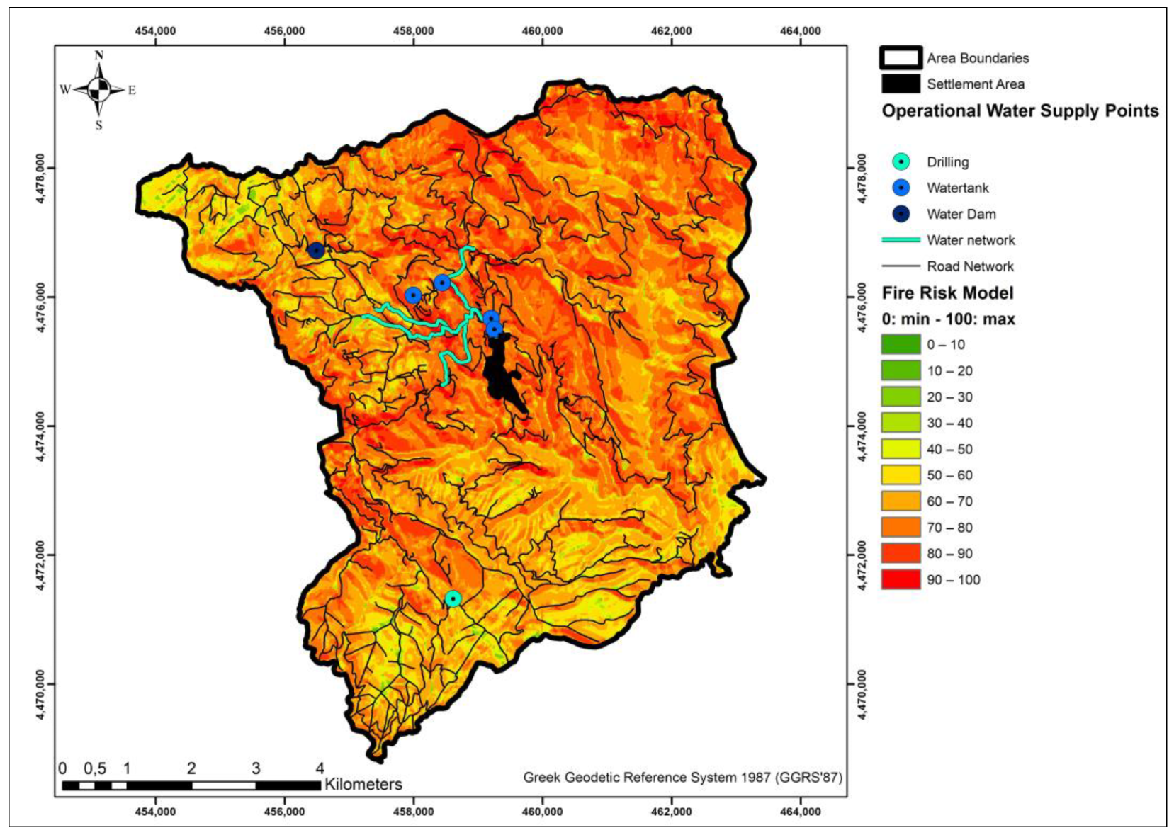
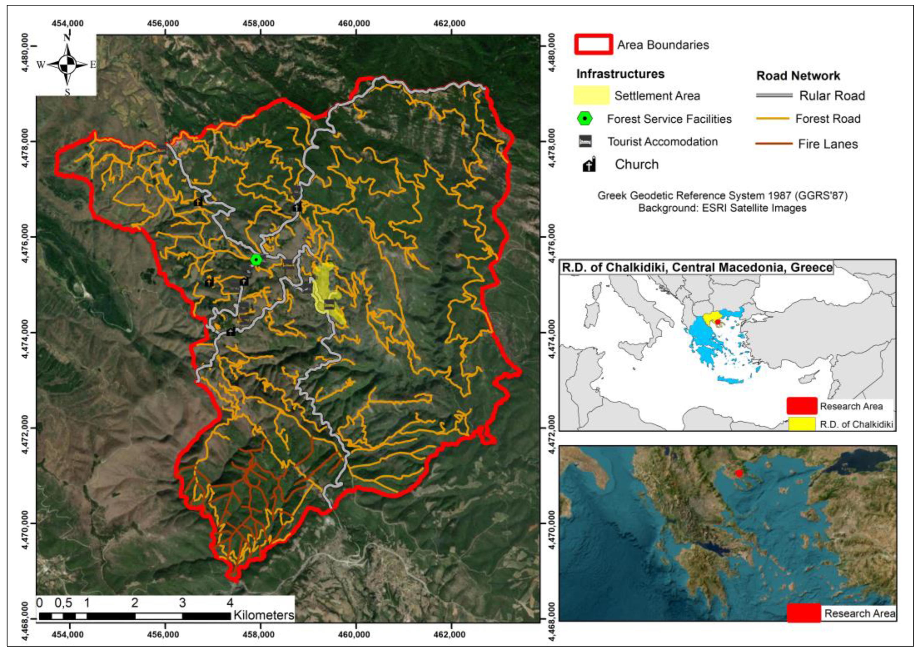
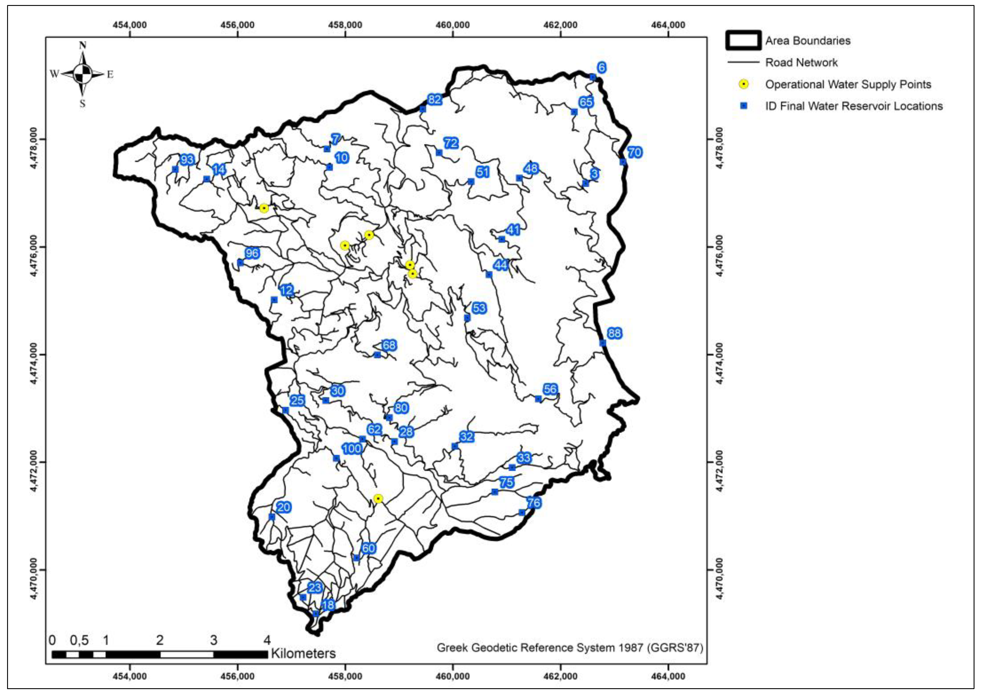
2.1. Research Area

The present research was implemented in the forest complex of Taxiarchis, R.D. of Chalkidiki, Greece. The area, as presented in Figure 1, is located within the administrative boundaries of the Regional Unit of Central Macedonia in northern Greece. It is situated between the parallels of geographic latitude 40°23′–40°28′ and geographic longitude 23°28′–23°34′, or, according to the Greek Geodetic Reference System of 1987 (GGRS ′87), in terms of E, from 452,700 to 463,875 and N, from 4,466,875 to 4,480,675. The elevation ranges from 320 to 1165 m. The area is owned by the Aristotle University of Thessaloniki, Thessaloniki, Greece, which utilizes it for research purposes and student workshops of the Department of Forestry and Natural Environmental Sciences. The total area corresponds to 5870.50 ha. Within these boundaries lies the settlement of Taxiarchis, which, according to the 2011 census data from the Hellenic Statistical Authority, has a population of 1070 residents. Additionally, the area encompasses the infrastructure of the forestry service and tourist accommodations. The entire region falls within the GR127001 and GR1270012 regions of the Natura 2000 network.

2.2. Data Collection

The implementation of the research necessitated the collection of essential geospatial data. The research area of Taxiarchis, Chalkidiki, possesses an approved management study titled “Management Plan of the University Forest Taxiarchis 2012–2021” formulated by the scientific team of the Administration and Management Fund of the Aristotle University of Thessaloniki. From this specific study, the following geospatial data were utilized: the boundaries of the area, the limits of settlements within it, the Digital Elevation Model (DEM), forested sections, tourist and anthropogenic installations, land uses, the hydrographic network, the delineation of the region’s watershed, water supply networks, existing water intake points, and orthophotos of the area.
The geospatial data pertaining to the road network of the area were sourced from the Greek Forestry Service. The region comprises a total road network of 228,823 m, of which, according to the categorization of the Greek Ministry of Infrastructure and Transport, 33,808 m correspond to asphalt-paved provincial roads, 44,428 m to Class A forest roads (width 6–8 m), 9730 m to Class B forest roads (width 4–6 m), and 140,857 m to Class C forest roads (width 4–5 m).
The present research also utilized wildfire risk data for the area, generated by the Institute of Forest Engineering and Surveying at the Aristotle University of Thessaloniki. Specifically, the raster model (Figure 2) with a resolution of 5 m × 5 m was employed. The model depicts the degree of fire occurrence risk on a scale of 0–100, considering 0 as the minimum probability and 100 as the maximum. The creation of the model incorporated the following factors: (a) slope of the terrain, (b) slope aspect, (c) type and density of fuel material, (d) distance from the road network, and (e) distance from anthropogenic infrastructure.

2.3. Identification of Suitable Locations for Deploying Firefighting Water Reservoirs

The proposed TOPSIS methodology suggested for the allocation of water reservoirs in this research constitutes a hierarchical process aimed at identifying the optimal solution from a set of alternative solutions based on predefined criteria. Therefore, it is imperative to create a set of potential locations for the installation of water reservoirs, which will subsequently be analyzed, evaluated, and ranked with the goal of finding the best locations. The allocation of the proposed water reservoirs is based on the assumption that they should be located on or in close proximity to the road network. The objective is to provide immediate accessibility for refueling firefighting vehicles to execute fire suppression operations.
The initial step taken to identify potential locations for the installation of anti-fire water reservoirs involved evaluating existing water intake positions. Utilizing the Network Analysis toolbox within the ArcGIS package, specifically the Service Area tool, segments of the road network served by existing water intake locations were identified within a 5-min travel time via optimal routes. Based on this analysis, the furthest point on the road network from an existing water intake location corresponds to a 5-min travel time. Consequently, in the event of firefighting operations, the total travel time for refueling a firefighting vehicle amounts to 10 min (travel to and from the water intake location to the operation site). These 5-min travel coverage areas toward the existing water intake locations were considered “exclusion zones”, and no new water tank installation locations are proposed on these road network segments, given the sufficient refueling time.
Subsequently, the Generate Points Along Lines tool in the ArcGIS 10.8 software was employed to create points every 1000 m along the road network, excluding the “exclusion zone”, as potential water reservoir installation points. A field visit was conducted to these generated points to assess the feasibility of water tank placement at each location. In cases where placement was not suitable (due to a lack of open space or steep slopes), the position was adjusted near the original and documented using topographic instruments.

2.4. Water Reservoir Allocation Criteria

The TOPSIS methodology aims at ranking the examined alternative solutions. The first step involves determining the criteria to be used for evaluating the alternatives. The allocation of water reservoirs is based on three key criteria. The first concerns the likelihood of fire occurrence at the specific placement location (fire risk criterion—FRC), the second involves the distance from existing water intake points (distance from existing water intake points criterion—EWC), and the third considers the coverage area size through optimal routes (optimal route area coverage criterion—ACC). The synthesis of these criteria contributes to the selection of the optimal location, addressing both the risk factor and the optimization of supply lines for firefighting vehicles. Having established the positions of potential water tank installation points, the next step involved calculating the values for each of the aforementioned criteria.

2.4.1. Fire Risk Criterion (FRC)

The level of fire occurrence risk is a crucial factor in selecting the optimal location for the installation of wildfire water tanks. To calculate the criterion value, Thiessen polygons were generated within the boundaries of the study area for each existing and potential installation site using the corresponding tool in ArcGIS 10.8 software. Thiessen polygons, or proximity zones, constitute a geographical model utilized in geostatistics to represent areas covered more closely by a set of points. Based on the Thiessen polygons created for each potential water reservoir installation site, the Zonal Statistics tool in ArcGIS was employed to compute the sum of fire occurrence risk degrees encompassed by each polygon, according to the gridded risk model of the study area.

2.4.2. Distance from Existing Water Intake Points Criterion (EWC)

The criterion of distance from existing water intake locations was established by considering the fact that the farther an area is from existing supply points, the more essential it is to create a supply installation in that specific area. This method defines areas in terms of optimizing the positions of water tank installations. The assessment of distances from potential water reservoir installation locations to existing water intake locations was conducted using the optimal routes in terms of travel time through the Network Analysis package of the ArcGIS software, applying the Closest Facilities tool. The algorithm calculated the minimum time to each potential installation site from the existing hydrant locations through the optimization of travel time along the best routes.

2.4.3. Optimal Route Area Coverage Criterion (ACC)

The placement of firewater reservoirs is crucial to facilitating the replenishment of firefighting vehicles. One of the key factors in achieving this is to position them strategically for easy and rapid access by firefighting forces. Using the Network Analysis package of the ArcGIS software, specifically the Service Area tool, the length of the road network that can be served within 5 min from each potential water tank installation site was calculated. This was performed through optimal routes, minimizing travel time. After defining the road network segments covered by each water tank within 5 min, the Buffer tool of ArcGIS was applied to these segments at a distance of 100 m. This process generated coverage polygons for each water tank, and their area was calculated as the value of the criterion.

2.5. Analytical Hierarchy Process (AHP)

The estimation of the weighting coefficients of the criteria for potential water reservoir installation sites was conducted using the analytic hierarchy process (AHP) method [47]. The application of the AHP method can be distinguished into four main stages: (a) problem identification and model definition; (b) criteria assessment and creation of the comparison matrix; (c) ranking; and (d) synthesis [48,49,51,52].
In the first stage, the problem is clearly defined, and the main objective is identified. The decision problem should be analyzed in a hierarchy of criteria and sub-criteria leading to the goal. This hierarchical structure allows for a systematic decision-making approach, ensuring that all relevant factors are considered. The second stage involves pairwise comparisons of criteria, sub-criteria, and alternatives. This is the pivotal point of the method, where individual criteria are compared with each other on a scale from 1 to 9, as presented in Table 1. This standardizes the qualitative and quantitative performance of the criteria.
The comparison of results in pairs constitutes the most critical step influencing the estimation of the weighting factors of location criteria. Preferences among the examined criteria in a pairwise comparison are based on the significance that each criterion holds in comparison to the others. For this purpose, a qualitative analysis is required during the comparison of criteria based on their hierarchy of importance. The comparison among the three location criteria for anti-fire water reservoirs (fire risk—FRC, optimal route area coverage—ACC, and distance from existing water intake points—EWC) was guided by the needs that the water reservoirs are expected to serve in the intended construction location. To achieve this, key stakeholders responsible for firefighting (Fire Department, Forestry Service) in the research area were consulted.
Pairwise comparisons facilitate decision-making by enabling the independent evaluation of each factor’s contribution [58]. The primary advantage of the analytic hierarchy process (AHP) is its inherent simplicity. Regardless of the number of criteria used, AHP consistently compares two criteria at a time. Another significant advantage is that, in addition to tangible variables, intangible variables are also taken into account [59]. The pairwise comparison method is presented in the following equation.
A = a 11 a 12 . a 1 n a 21 a 22 . a 2 n a n 1 a n 2 . a n n
The next crucial step in implementing the method is the consistency check. Verification is essential since human judgment can be subject to inconsistencies. Although AHP is a reliable evaluation process on its own, the accuracy of results depends on the consistency of the pairwise comparisons of criteria and sub-criteria. Therefore, the consistency ratio (CR) is calculated for this purpose. CR allows testing pairwise comparisons between criteria that need to be assessed to determine this consistency. The AHP process continues if the CR value is less than 0.10. Any CR value greater than 0.10 indicates insufficient consistency in the comparison matrix [57,60]. If this occurs, it is necessary to review and modify the comparisons to reduce the inconsistency to less than 0.10. The CR index is calculated by applying the following equations:
C R = C I R I ,   C I = λ m a x n n 1
where CR: consistency ratio, RI: random index based on the number of criteria, CI: consistency index, λmax: the average of the consistency matrix, and n: the number of criteria.
The value of the RI coefficient in Equation (2) depends on the number of factors being compared and is derived from the literature of the method according to Table 2.

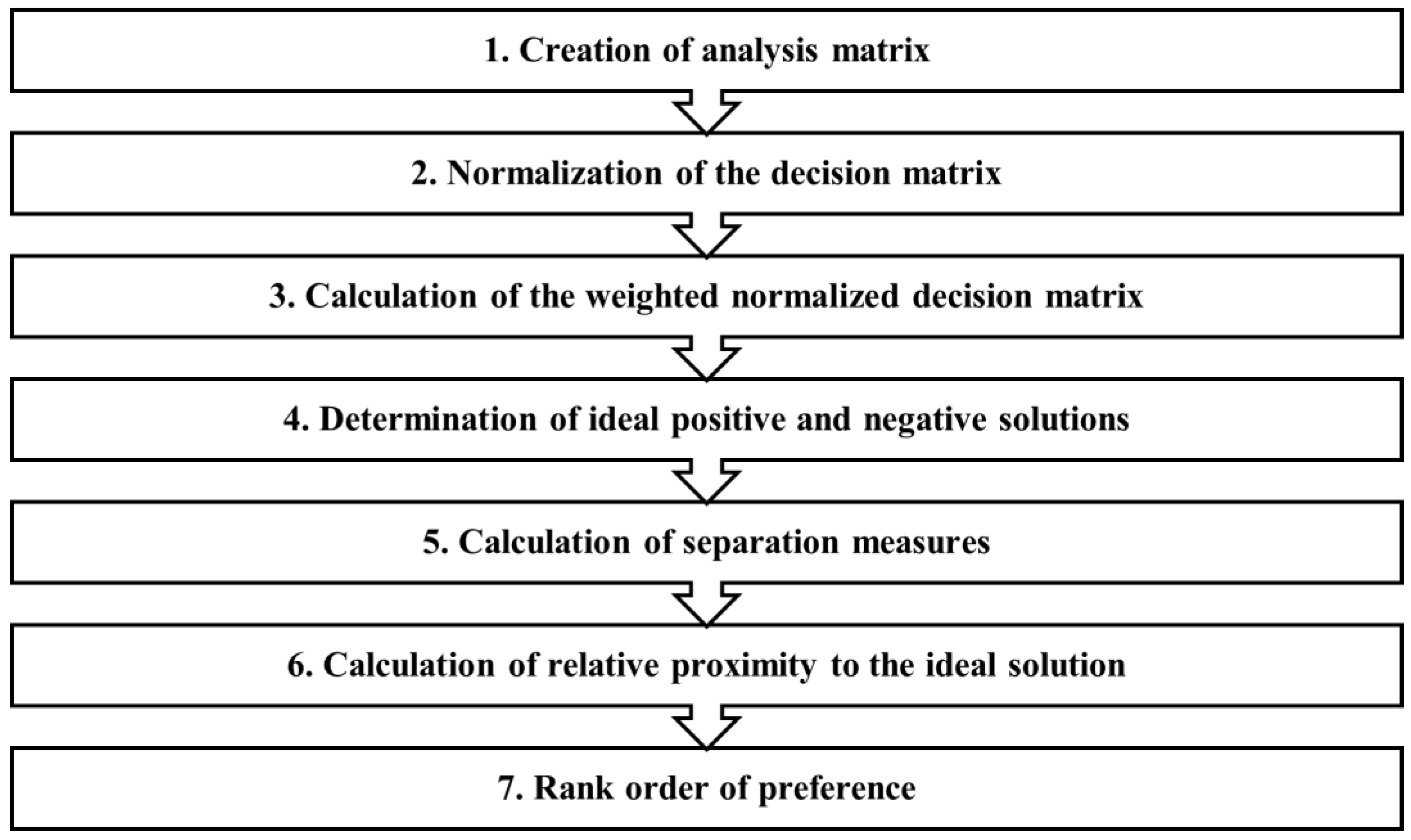
2.6. Technique for Order of Preference by Similarity to Ideal Solution (TOPSIS)

The TOPSIS method’s hierarchy process can be distinguished into seven main steps, as presented in Figure 3 [61,62]. The initial step involves creating a matrix containing m alternatives and n criteria [63,64,65]. In the context of this research, potential locations for installing water reservoirs are considered as m alternatives, and n criteria include the fire risk at each location (FRC), the distance from existing water intake points (EWC), and the service coverage area (ACC).
The second step involves normalizing the analysis matrix according to Equation (3).
R = r i j m × n ,   ó π ο υ   r i j = x i j i = 1 m x i j 2   ,   i = 1,2 , . m   ,   j = 1,2 ,   . n
where m: the alternative solutions, n: the criteria, and x: the values of the criteria.
The third step involves calculating the weighted normalized matrix in accordance with Equation (4).
t i j = r i j   w j   ,   i = 1,2 , . m   ,   j = 1,2 ,   . n
where m: the alternative solutions, n: the criteria, r: the normalized value of each criterion for each alternative, and w: the weighting coefficient for each criterion.
The fourth step involves determining the ideal positive and negative solutions. From the weighted normalized matrix of the analysis, the ideal best and worst values for each criterion are calculated.
V j + ,   V j
where V: the value of the ideal solution and j: the specific criterion.
The fifth step of the TOPSIS methodology involves calculating the Euclidean distance between the values of the criteria for each alternative solution and the worst and best ideal solutions. This calculation is based on Equation (6).
S i + = j = 1 m ( V i j V j + ) 2 0.5 , S i = j = 1 m ( V i j V j ) 2 0.5 ,
where S+: the Euclidean distance from the best ideal solution, S: the Euclidean distance from the worst ideal solution, and V+, V: the values of the best and worst ideal solutions.
The sixth step of the method involves calculating the performance score of the relative closeness to the worst ideal state. These values are determined based on Equation (7).
P i = S i ( S i + + S i )
where Pi: the performance rating concerning the proximity to the worst ideal state, S+: the Euclidean distance from the best ideal solution, and S: the Euclidean distance from the worst ideal solution.
The seventh and final step of the methodology involves ranking the results. In the case of this research, the alternative solutions—the potential installation sites for anti-fire water reservoirs—are ranked according to their performance rating (Pi) from highest to lowest. The order of the ranking corresponds to the optimal sequence of the water reservoir installation locations based on the criteria defined for the application of the TOPSIS methodology.

2.7. Final Selection

After completing the ranking of potential locations for the installation of water reservoirs, the final selection of allocation occurred. According to the TOPSIS methodology hierarchy, all these potential locations are ranked from the best to the least efficient. However, the methodology for finding potential installation locations for anti-fire water reservoirs yields a large number of positions in close proximity. Based on this analysis, a successive selection system for final positions was applied. From the table of the final ranking, the first hierarchically ranked installation position was selected. From this first position, the Service Area tool of the ArcGIS Network Analysis package was applied. The segments of the road network corresponding to the zone of optimal 5-min routes were identified. All potential positions in the ranking table within the 5-min zone from the first choice were deleted. Subsequently, the next hierarchically potential position from the remaining alternatives in the ranking table was selected as the second choice. Following this, the alternative positions within the 5-min zone of optimal routes from this second position were deleted. This process continued until all potential water tank installation positions in the ranking table were selected and deleted.
The application of this process determines the final positions for the installation of anti-fire water reservoirs. In this way, the new locations of water reservoirs, in combination with existing water intake points, provide complete coverage of the road network from all points within 5 min via optimal routes.

3. Results

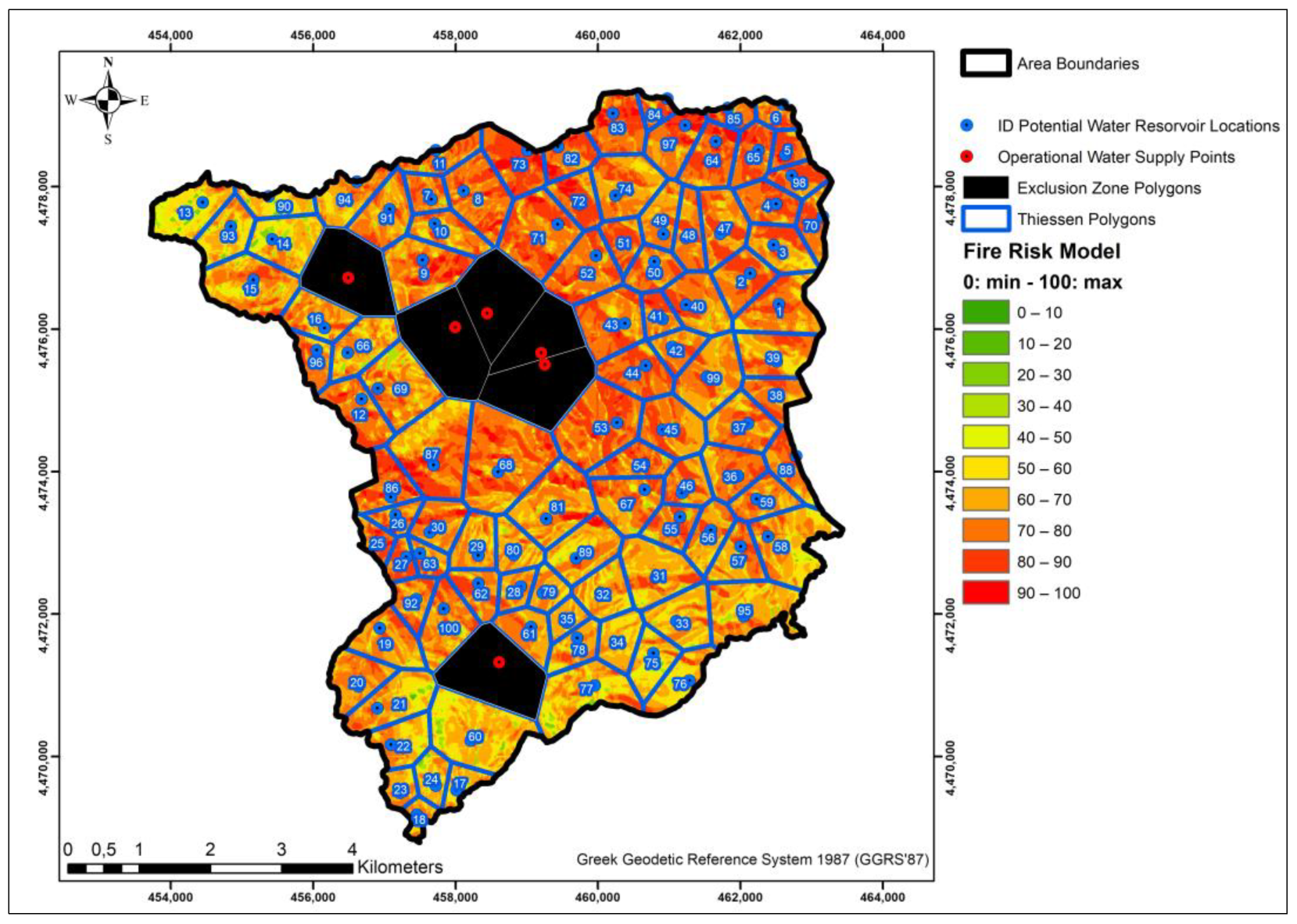
3.1. Selection of Potential Sites for the Installation of Fire Suppression Water Tanks

In the research area of Taxiarchis, Chalkidiki, a total of six existing water intake points operate based on data from the area’s management plan. Additionally, to serve the settlement of Taxiarchis and nearby facilities, there is a water supply network with a total length of 8386 m. The execution of the Service Area tool in ArcGIS from the existing water intake points revealed that 79,376 m of the road network are served by them within a response time of 0–5 min along optimal routes. This length corresponds to a percentage of 34.73% of the total length of the road network. Within this area, the entire water supply network of the region is also included. This region covered within 5 min of optimal routes is considered an “exclusion zone”, and potential locations for the installation of firewater tanks are not recommended within it.
Following the placement of points every 1000 m along the road network and subsequently conducting on-site visits for the precise determination of locations, a total of 100 potential installation locations for firewater tanks were selected, as illustrated in Figure 4.

3.2. Evaluation of Allocation Criteria

The fire risk criterion (FRC) for each potential installation location of the water reservoir was calculated using Thiessen polygons, as presented in Figure 5. In total, 106 polygons were created, covering 100 potential water reservoir locations and 6 existing water intake points. The polygons of the existing water intake points were not considered in the calculation. For each of the polygons corresponding to the potential installation locations of the water reservoirs, the sum of the scores was calculated based on the fire risk analysis data.
The criterion of distance for each potential installation location of the water reservoirs from existing water intake points (EWC) was calculated (Figure 6) as the travel time along optimal routes, corresponding from each potential installation location to the nearest water intake point. For the 100 potential installation locations in total, the closest existing water intake point was identified, and the travel time in minutes was calculated using the optimal road network route.
The calculation of the coverage area criterion (ACC) through optimal routes, aiming at spatial allocation using the TOPSIS methodology, relied on the application of the Service Area tool within the ArcGIS software. As presented in Figure 7, through this tool, the segments of the road network served by each potential installation location of the firewater tank were identified. Subsequently, the area of the polygon covering these segments was calculated, considering a horizontal distance of 100 m.

3.3. Implementation of the AHP Method

During the initial stage of applying the analytic hierarchy process (AHP) for estimating the weight coefficients, the comparison matrix among the criteria was created, and the integer values were calculated (Table 3). Subsequently, the normalized matrix was constructed by dividing each value in the comparison matrix by the sum of the elements in the corresponding column (Table 4). The pairwise comparison among the examined allocation criteria was based on the opinions of entities responsible for implementing wildfire suppression operations. The authorities considered the most crucial criterion for siting anti-fire water reservoirs to be the points of highest fire risk. In addition, they deemed it necessary for anti-fire water reservoirs to be located in positions that facilitate the quickest supply to firefighting vehicles. Finally, the distance from existing locations was considered the least significant criterion.
Subsequently, the methodology for calculating the consistency ratio (CR) was applied to assess consistency (Table 5). The integer values from the pairwise comparison results were multiplied by the weighting coefficient. The results were then aggregated, yielding the weighted sum of values per row. This weighted sum per row was further multiplied by the respective weighting coefficient, resulting in the consistency ratio (λ) for each criterion.
The computation of the λmax value resulted in the average of the consistency values (λ) for each criterion, calculated as follows: λmax = (3.08 + 3.053435115 + 3.030120482)/3 = 3.0537. The consistency index (CI) for a total of three criteria was derived using Equation (2), as follows: CI = (3.0537 − 3)/(3 − 1) = 0.0268709. The consistency ratio (CR), determined by applying Equation (2) and utilizing the Random Index (RI) for three criteria based on the values in Table 2, was calculated as follows: CR = 0.0268709/0.58 = 0.0463292. Given that the CR result is less than 0.10, the consistency check of the AHP method in pairwise comparisons is considered acceptable.

3.4. Implementation of the TOPSIS Method

The first step in the application of ranking using the TOPSIS methodology was the construction of the initial analysis matrix based on the values of the allocation criteria for each of the potential installation sites of water reservoirs. The goal and the applied weighting coefficient of each criterion is presented in Table 6. The initial matrix (Table 7) comprises 100 alternatives, considered as potential locations for the installation of anti-fire water reservoirs, and the values of the three criteria: the potential location of fire risk (FRC), the minimum optimal distance from an existing water intake point (EWC), and the coverage area of the zone within 5 min of the optimal routes (ACC). The weighting coefficients of each criterion are derived from the application of AHP.
The second step involved normalizing the criteria values of the alternatives (potential installation sites for water reservoirs). The sum of the squares of the values for each alternative solution for the fire risk criterion (FRC) was 632,220,345,912,922, and its square root was 25,143,992,24. For the criterion of minimum travel time from an existing water intake (EWC), it was 14,865.8 with a square root of 121.93. Finally, for the criterion of coverage area within the 5-min zone (ACC), the sum of the squares was 154,145,563,597,978, and its square root was 12,415,537.19. The normalized values are presented in Appendix A, Table A1.
During the implementation of the third step of the TOPSIS methodology, the values of the normalized decision matrix were multiplied by the respective weight coefficient of each criterion, according to the results of AHP. Thus, the normalized values of the alternatives for the fire risk criterion (FRC) were multiplied by the coefficient 0.50, for the criterion of travel time from an existing water intake (EWC) by the coefficient 0.20, and for the criterion of coverage area within the 5-min zone (ACC) by the coefficient 0.30. The weighted normalized values are demonstrated in Appendix A, Table A2.
The fourth step of implementing the TOPSIS methodology involves identifying the ideal best and worst values for the criteria from the weighted normalized decision matrix of the decision-making matrix. The values are presented in Table 8. Given that the objective for ranking alternative locations for the installation of water tanks is to maximize the values of each criterion, the maximum value was calculated as the best and the minimum value as the worst.
The implementation of the fifth step of the TOPSIS methodology yielded the Euclidean distances of the values from the weighted normalized matrix of potential installation locations for the water reservoirs. From the criterion values of each alternative (rows of the weighted normalized value matrix—Appendix A, Table A2), the respective ideal solutions (best and worst for each case) were subtracted. This process produced, for each alternative, the Euclidean distance from the best ideal solution (S+) and from the worst (S).
In the sixth step of the methodology, the performance score (Pi) of the proximity to the worst ideal solution was calculated. The results from the completion of the fifth and sixth steps of the TOPSIS methodology are presented in Appendix A, Table A3. Finally, the final ranking of potential locations for the installation of anti-fire water reservoirs was conducted based on the performance score (Pi). The final results are presented in Table 9.

3.5. Final Selection of Water Reservoir Locations

Based on the final ranking (Table 9) of potential locations for the installation of anti-fire water reservoirs, the first hierarchically selected placement for a new water reservoir is Position 18. From position 18, the Service Area tool of the ArcGIS Network Analysis package was applied for optimal 5-min routes, and water tanks were found at positions 17 and 24 falling within this zone. The water reservoirs at these positions were removed from the table, thus completing the selection of the first installation position and the first site planning cycle. Following the removal of positions from the first planning cycle, the next immediate hierarchy is position 7, which is considered the selection for the second installation position. Within the 5-min zone, Positions 11 and 8 fell, and they were removed, completing the second cycle. Immediately following in hierarchy as the third installation option is position 28, from which positions 29, 79, 35, and 78 fall within the 5-min optimal routes and were removed. This process was subsequently repeated for a total of 34 installation and site planning positions. The final selected locations for the establishment of fire suppression water reservoirs, are presented in Figure 8.

4. Discussion

The application and development of wildfire planning in Greece today lack a comprehensive system for assessing the adequacy and siting of water supply points for firefighting operations. This deficiency results in the difficulty of effectively suppressing wildfires, with immediate consequences posing risks to the sustainability of forests. The present research constitutes a comprehensive decision support system for the strategic allocation of anti-fire water reservoirs in Mediterranean forest ecosystems, enabling the precise determination of installation locations based on criteria analysis. The methodology is a fusion of the analytic hierarchy process (AHP) and technique for order of preference by similarity to ideal solution (TOPSIS) methods. These tools are versatile and can be parametrized to better adapt to specific local conditions. Furthermore, this approach empowers relevant authorities responsible for wildfire prevention and suppression by providing them with a robust tool to achieve optimal resource allocation.
The imperative to minimize response time during the onset of a forest fire is of paramount importance in fire management strategies. Swift and efficient action in the early stages of a wildfire is critical for preventing its rapid spread and mitigating its potential catastrophic consequences [66]. The Network Analysis method has been used in order to tackle the optimization of routes, aiming to minimize the travel time from the parking positions of firefighting vehicles to the location of a forest fire outbreak [67,68]. While this approach is instrumental in enhancing the efficiency of emergency response logistics, a critical challenge arises concerning the adequacy of resources at specific locations and the availability of water. The optimization of routes must not only consider the temporal aspect but also account for the sufficient allocation of resources and water availability at key points along the paths. Balancing the trade-off between minimizing travel time and ensuring the availability of crucial resources is paramount for developing robust and effective strategies for combating forest fires [69]. Efficiently distributing water collection points in strategic locations holds significance as it streamlines the refueling process for forest firefighting vehicles, resulting in time and fuel savings. This strategic allocation takes precedence due to its direct correlation with economic losses and the scale of the firefighting area. The quicker the combat time, the lower the associated environmental, economic, and resource implications.
In the study area of Taxiarchis, Chalkidiki, the analysis revealed that only 34.73% of the area (Figure 4) is within a 5-min distance from existing water supply points. Consequently, the travel time for replenishment corresponds to a total of 10 min (round trip). It is emphasized that this time solely describes the travel time and does not account for the overall replenishment time, which is significantly greater and is subject to other parameters such as water pumping speed and available personnel. The placement of an additional 34 water tanks ensures complete coverage of the entire area, allowing for immediate replenishment capability. The 5-min replenishment coverage time for firefighting vehicles was deemed optimal for comprehensive fire protection in the area. It is noteworthy that in cases of resource constraints for installing such a large number of water tanks, this quantity can be adjusted to ten minutes or more, utilizing the same ranking matrix.
The initial step in implementing the methodology involves defining the criteria and parameters that ensure the optimal selection of installation sites for firewater tanks. These parameters are integrated into the analytic hierarchy process (AHP), and their weight coefficients are computed, enabling researchers to assess their contribution to the ultimate objective and determine their interrelations. The chosen parameters and criteria are deemed to align most effectively with the specific characteristics and requirements of the research area in Taxiarchis, Chalkidiki. The significant advantage lies in their adaptability and configurability, allowing for customization during application in different regions.
Analytical hierarchy process (AHP) is a decision-making methodology widely employed for spatial allocation, particularly in infrastructure siting [70,71,72,73,74,75]. In comparing AHP with other similar methods, it becomes evident that each approach has its own unique characteristics and strengths. One alternative, the analytic network process (ANP), shares the hierarchical structure with AHP but offers greater flexibility in handling complex relationships among decision criteria [76,77]. While ANP excels in intricate scenarios, AHP remains a more straightforward choice for problems with clear hierarchies and well-defined criteria [78]. Another method, simple additive weighting (SAW), simplifies the process by directly assigning weights to criteria based on perceived importance [79,80]. AHP, in contrast, utilizes pairwise comparisons to establish more nuanced and consistent weightings. This allows AHP to capture the relative importance of criteria in a more robust manner, fostering a more comprehensive understanding of decision factors. The advantages of AHP lie in its ability to systematically structure decision problems, involve stakeholders through pairwise comparisons, and ensure consistency in judgments through a rigorous validation process. The pairwise comparisons in AHP contribute to a more accurate representation of the decision-makers’ preferences, leading to more reliable and informed decisions. Additionally, AHP facilitates sensitivity analysis, enabling a deeper exploration of how changes in criteria weights impact overall outcomes.
The second phase of the proposed methodology facilitates the completion of the site selection process and the establishment of a hierarchy by integrating social criteria. Employing the technique for order of preference by similarity to ideal solution (TOPSIS) with the outcomes derived from the analytic hierarchy process (AHP) enabled us to formulate a ranking hierarchy for the locations, assigning precise rankings to each. The TOPSIS methodology (technique for order of preference by similarity to ideal solution) represents an efficient approach for the hierarchical evaluation and selection of infrastructure siting locations. Comparing TOPSIS with various other methods, including ELECTRE (elimination and choice translating reality) and PROMETHEE (preference ranking organization method for enrichment evaluations), offers insights into their distinctive characteristics. TOPSIS distinguishes itself through a comparative analysis that gauges the similarity of each alternative to both the ideal and anti-ideal solutions [81]. This dual consideration of positive and negative aspects contributes to a comprehensive evaluation. ELECTRE focuses on outranking relationships among alternatives based on predetermined criteria thresholds. Its strength lies in handling imprecise data and capturing partial preferences, but it may encounter challenges when dealing with a large number of alternatives [82]. PROMETHEE employs a different approach by constructing partial pre-orders for each alternative and then aggregating them to obtain a global preference ranking. This method accommodates various preference functions, allowing for flexibility in decision modeling [83].
The results of the research have indicated that the application of multi-criteria analyses, along with the analytic hierarchy process (AHP) and technique for order of preference by similarity to ideal solution (TOPSIS) methods, can identify suitable locations for the placement of water intake points. The objective is to ensure optimal efficiency for wildfire suppression operations and, consequently, enhance the sustainability of forest ecosystems. The analysis of criteria related to fire danger and the optimization of travel time to water intake points yield a comprehensive system. In this system, firefighting can be executed within a critical time frame, preventing the fire from escalating into a megafire. The establishment of appropriate water intake infrastructure has the potential to mitigate the spread of forest fires and, by extension, contribute to the sustainable management of forest ecosystems.

5. Conclusions

The selection of the anti-fire water reservoir locations through the TOPSIS methodology was based on the identification of 100 potential installation points, which were ranked for optimal selection. Out of these candidate locations, a total of 34 were ultimately chosen. By installing firewater tanks at these 34 positions, firefighting vehicles can access water supply points within a 5-min travel time. The on-site analysis holds significant importance, as local conditions must be taken into account to ensure the practicality of the methodology and attain feasible results.
Water reservoirs come to address the gap in the direct replenishment of firefighting vehicles during forest fire incidents. They constitute a viable solution to meet the water needs of forested areas and enhance the operational efficiency of firefighting operations. The strategic placement of these reservoirs is crucial for ensuring rapid response and effective fire suppression. By strategically distributing water reservoirs, emergency responders gain access to readily available water sources, significantly reducing the time required for firefighting vehicles to refill and return to the front lines. Moreover, the implementation of water reservoirs contributes to the overall resilience of forest ecosystems. By securing a stable water supply, especially in remote or challenging terrains, these reservoirs enhance their capacity to combat wildfires swiftly and efficiently. This integrated approach aligns with the principles of sustainable wildfire prevention planning. The systematic deployment of water reservoirs, combined with advanced decision-making methodologies such as AHP-TOPSIS, offers a comprehensive strategy for optimizing resource allocation and minimizing response times during critical firefighting scenarios.
The selection of optimal installation sites for anti-fire water reservoirs represents a topic of significant research interest. In this study, the TOPSIS methodology was employed, providing a comprehensive evaluation of fire hazard levels, proximity to hydrant locations, and the coverage area within five-minute optimal routes. This method can be expanded to include additional criteria for a more nuanced assessment.
A primary limitation of this research was the availability and reliability of primary data. The analysis of criteria, including the distance from existing hydrant points and the coverage area of the proposed locations, relied on the network and optimal route analysis of the forest roads. The road network data were limited to the boundaries of the study area, excluding the calculation of roads in proximity. The inclusion of these roads might have influenced the results. Additionally, the research area lacks a standardized fire hazard rating system. Clear and accurate data on fire hazards on a small scale are necessary for the appropriate implementation of similar studies.
Future research endeavors could incorporate unique site characteristics as location criteria. Factors such as the feasibility of constructing water supply systems, the potential for direct firefighting operations from the reservoir, and the capability to replenish firefighting helicopters directly could be considered in the decision-making process. These additional criteria aim to enhance the precision and adaptability of the methodology, ensuring a more tailored and effective approach to the selection of installation sites for firefighting water reservoirs.
The integration of these criteria into the decision-making framework offers a holistic perspective on site suitability, reflecting the specific attributes and capabilities of each potential location. This approach not only contributes to the refinement of the methodology but also ensures that future installations align with the unique requirements and challenges presented by diverse geographical and environmental contexts. The ongoing exploration and integration of diverse criteria into the decision-making process will contribute to the continuous improvement and applicability of the methodology for optimal firefighting water reservoir placement. The adaptability of the TOPSIS methodology positions it as a valuable tool for addressing the dynamic challenges associated with wildfire prevention and response planning. Τhe incorporation of water reservoirs into wildfire prevention plans stands as a practical and efficient measure. It not only addresses the immediate needs of firefighting operations but also reinforces the broader goal of safeguarding ecosystems and communities against the devastating impact of forest fires. The prevention of forest wildfires is an integral part of forest sustainability and, by extension, the implementation of measures for climate change adaptation.
The research offers a systematic and adaptable framework for forest and firefighting services, as well as various stakeholders for sustainable wildfire management. Furthermore, the applicability of this methodology extends beyond theoretical discourse, presenting a practical and scalable solution that can be implemented across diverse forested landscapes. Ultimately, the adoption of this holistic approach is envisioned not only as a catalyst for enhancing the effectiveness of firefighting strategies but also as a transformative force in bolstering the resilience and sustainability of forested regions. Forest and firefighting services, alongside engaged stakeholders, are encouraged to embrace this methodological innovation, recognizing its potential to redefine and advance the sustainable management of forest ecosystems in the face of the escalating global challenge posed by forest fires. The present methodology could be used to aid in the implementation of policies in the framework of the United Nations’ sustainable development goal regarding climate change (SDG 13) and the European Union’s forest sustainability policies.

Author Contributions

Conceptualization, G.K. and G.A.; methodology, G.K. and A.S.; software, G.K. and S.T.; validation, G.K., A.S. and A.K.; formal analysis, G.K. and G.A.; investigation, G.K. and A.S.; resources, G.K. and A.S.; data curation, G.K. and S.T.; writing—original draft preparation, G.K.; writing—review and editing, G.K.; visualization, G.K. and A.K.; supervision, G.K.; project administration, G.A.; funding acquisition, G.K. All authors have read and agreed to the published version of the manuscript.

Funding

This research is part of the Ph.D. Thesis (title: Allocation, dimensioning, and optimal route selection for forest engineering projects using G.I.S. as an integrated wildfire management system) of G. Kolkos, whose Ph.D. work has been carried out at the Institute of Forest Engineering and Surveying of Aristotle University of Thessaloniki, Greece. The implementation of the doctoral thesis is co-financed by Greece and the European Union (European Social Fund: ESF) by the Greek State Scholarships Foundation (2022-050-0502-52027) through the Operational Program “Human Resources Development, Education and Lifelong Learning” in the context of the act “Enhancing Human Resources Research Potential by Undertaking Doctoral Research”, Sub-action 2: IKY Scholarship Program for Ph.D. Candidates in Greek Universities.

Institutional Review Board Statement

Not applicable.

Informed Consent Statement

Not applicable.

Data Availability Statement

The data presented in this study are available on request from the corresponding author.

Acknowledgments

We would like to thank the staff of the Aristotle University of Thessaloniki Forest Fund and the Forest Service of Thessaloniki for providing us the geospatial data for the implementation of our research. In addition, we would like to thank all the authors in the reference section οn whose research we relied on.

Conflicts of Interest

The authors declare no conflicts of interest.

Appendix A

Table A1. Normalized values matrix of TOPSIS methodology.
IDFRCEWCACCIDFRCEWCACCIDFRCEWCACC
10.12780.16660.0969350.03650.05370.2325690.14390.04640.0662
20.09490.15020.1055360.09290.17720.0598700.05650.16170.0264
30.08700.16280.0909370.10630.19940.0597710.18180.06550.0482
40.08420.14430.0811380.06680.21240.0743720.07850.09220.0275
50.04440.12430.0891390.10680.19180.0790730.11690.05400.0719
60.03470.10370.0912400.10790.10260.0752740.12800.11920.0315
70.05300.06530.0546410.04950.08540.0706750.06410.06730.0874
80.14830.04740.0583420.05740.06690.0811760.06850.08090.0404
90.15940.04790.0659430.14180.04910.1020770.13960.04820.1979
100.08140.06460.0653440.11310.07190.0544780.05980.04780.2399
110.06230.10550.0309450.11610.10590.0534790.04490.06010.2048
120.10540.05060.0850460.07110.08600.1031800.06260.06650.1638
130.08600.09360.0766470.11070.12930.0853810.16300.05260.1394
140.09260.05460.1181480.07500.11290.0872820.07400.05110.1336
150.14510.05640.0674490.07110.09370.0943830.11540.06500.1256
160.08560.05690.0807500.07160.07590.0774840.03220.07890.1239
170.03910.11070.0529510.06050.05950.0685850.03730.09170.1070
180.02840.12770.0346520.13580.04240.1017860.09560.05010.2283
190.10200.08810.0607530.20740.05060.1063870.21160.04900.2269
200.09020.11700.0405540.07830.06770.1001880.06570.19510.0441
210.10660.14790.0357550.06760.08900.1012890.10620.08420.0759
220.07200.16220.0362560.07430.10190.0713900.04750.05720.1620
230.03780.13440.0400570.08050.12040.0620910.10360.05870.1022
240.04490.10670.0555580.14010.13900.0646920.06120.06590.0937
250.04080.07410.1011590.07260.15540.0719930.07400.07890.0912
260.04220.05610.1876600.17710.07070.0438940.08350.05660.1055
270.04100.08170.1080610.07440.06360.1188950.14000.10950.0569
280.04410.07920.0746620.06960.08350.0864960.05510.05650.0825
290.07320.10700.0464630.03800.07350.1354970.10100.09270.1006
300.07850.08870.0651640.10890.10610.0694980.05520.13070.0903
310.12590.10710.0506650.08130.13490.0303990.13090.10200.0240
320.07690.08140.0925660.09250.04310.14841000.11450.05010.0759
330.09540.08640.0902670.11470.08100.0824
340.06380.07520.1377680.26940.06830.0522
Table A2. Weighted normalized values matrix TOPSIS methodology.
IDFRCEWCACCIDFRCEWCACCIDFRCEWCACC
10.06390.03330.0291350.01820.01070.0697690.07190.00930.0199
20.04740.03000.0316360.04650.03540.0179700.02820.03230.0079
30.04350.03260.0273370.05310.03990.0179710.09090.01310.0145
40.04210.02890.0243380.03340.04250.0223720.03930.01840.0083
50.02220.02490.0267390.05340.03840.0237730.05840.01080.0216
60.01740.02070.0274400.05390.02050.0226740.06400.02380.0095
70.02650.01310.0164410.02480.01710.0212750.03210.01350.0262
80.07410.00950.0175420.02870.01340.0243760.03420.01620.0121
90.07970.00960.0198430.07090.00980.0306770.06980.00960.0594
100.04070.01290.0196440.05650.01440.0163780.02990.00960.0720
110.03120.02110.0093450.05800.02120.0160790.02240.01200.0614
120.05270.01010.0255460.03560.01720.0309800.03130.01330.0491
130.04300.01870.0230470.05530.02590.0256810.08150.01050.0418
140.04630.01090.0354480.03750.02260.0262820.03700.01020.0401
150.07260.01130.0202490.03550.01870.0283830.05770.01300.0377
160.04280.01140.0242500.03580.01520.0232840.01610.01580.0372
170.01960.02210.0159510.03030.01190.0206850.01870.01830.0321
180.01420.02550.0104520.06790.00850.0305860.04780.01000.0685
190.05100.01760.0182530.10370.01010.0319870.10580.00980.0681
200.04510.02340.0122540.03920.01350.0300880.03290.03900.0132
210.05330.02960.0107550.03380.01780.0304890.05310.01680.0228
220.03600.03240.0109560.03710.02040.0214900.02380.01140.0486
230.01890.02690.0120570.04020.02410.0186910.05180.01170.0307
240.02250.02130.0167580.07010.02780.0194920.03060.01320.0281
250.02040.01480.0303590.03630.03110.0216930.03700.01580.0274
260.02110.01120.0563600.08860.01410.0131940.04180.01130.0317
270.02050.01630.0324610.03720.01270.0356950.07000.02190.0171
280.02210.01580.0224620.03480.01670.0259960.02760.01130.0248
290.03660.02140.0139630.01900.01470.0406970.05050.01850.0302
300.03920.01770.0195640.05450.02120.0208980.02760.02610.0271
310.06300.02140.0152650.04060.02700.0091990.06540.02040.0072
320.03850.01630.0277660.04630.00860.04451000.05730.01000.0228
330.04770.01730.0271670.05730.01620.0247
340.03190.01500.0413680.13470.01370.0156
Table A3. Results of the calculation of Euclidean distances and performance scores of the TOPSIS methodology.
IDS+SPiIDS+SPiIDS+SPi
10.08330.05970.4175350.12070.06270.3418690.08810.05910.4017
20.09700.04650.3244360.10370.04340.2950700.12470.02770.1818
30.10210.04290.2960370.09790.05120.3432710.07800.07720.4973
40.10500.03860.2685380.11290.04190.2706720.11730.02700.1872
50.12260.02670.1790390.09470.05200.3545730.09680.04660.3249
60.12740.02380.1575400.09720.04430.3130740.09620.05220.3517
70.12520.01600.1135410.12380.01950.1363750.11610.02660.1862
80.08790.06080.4090420.11980.02300.1609760.11990.02200.1554
90.08270.06670.4465430.08280.06140.4257770.07380.07620.5080
100.11160.02960.2097440.10000.04370.3042780.10990.06660.3775
110.12290.02130.1474450.09730.04650.3235790.11680.05500.3199
120.09970.04260.2996460.11020.03310.2309800.10990.04550.2929
130.10660.03440.2440470.09340.04830.3409810.06900.07570.5233
140.10080.04280.2981480.10930.03320.2329820.10770.04000.2709
150.08670.05990.4085490.11090.03170.2222830.08930.05330.3736
160.10820.03340.2359500.11360.02770.1961840.12650.03090.1963
170.12970.01700.1162510.12040.02120.1496850.12500.02720.1784
180.13640.01740.1129520.08570.05860.4060860.09280.06990.4296
190.10250.03950.2781530.06010.09290.6070870.04380.11000.7153
200.10940.03470.2407540.10830.03420.2401880.11760.03630.2359
210.10270.04460.3027550.11190.03180.2211890.09870.04270.3022
220.11660.03260.2186560.11210.02950.2083900.11760.04260.2658
230.13130.01960.1299570.11010.03240.2277910.09760.04440.3128
240.12690.01800.1241580.08460.06040.4163920.11670.02700.1879
250.12480.02480.1657590.11120.03470.2380930.11070.03130.2205
260.11890.04960.2945600.08000.07480.4834940.10600.03690.2585
270.12370.02710.1799610.10820.03680.2539950.08730.05820.4000
280.12590.01860.1287620.11300.02900.2043960.12120.02220.1550
290.11590.02670.1873630.12310.03430.2180970.09700.04410.3125
300.11170.02940.2084640.09750.04440.3127980.11730.02980.2026
310.09390.05110.3524650.11420.03230.2206990.09740.05260.3508
320.10910.03270.2307660.09860.04920.33291000.09730.04580.3201
330.10110.03990.2832670.09440.04720.3333
340.11070.03900.2604680.06330.12090.6565

References

  1. Kolanek, A.; Szymanowski, M.; Małysz, M. Spatio-Temporal Dynamics of Forest Fires in Poland and Consequences for Fire Protection Systems: Seeking a Balance between Efficiency and Costs. Sustainability 2023, 15, 16829. [Google Scholar] [CrossRef]
  2. European Commission, Joint Research Centre; San-Miguel-Ayanz, J.; Durrant, T.; Boca, R.; Libertà, G.; Branco, A.; De Rigo, D.; Ferrari, D.; Maianti, P.; Artés Vivancos, T.; et al. Forest fires in Europe, Middle East and North Africa 2018; Publications Office of the European Union: Luxembourg, 2019. [Google Scholar] [CrossRef]
  3. Kartsios, S.; Karacostas, T.; Pytharoulis, I.; Dimitrakopoulos, A.P. Numerical investigation of atmosphere-fire interactions during high-impact wildland fire events in Greece. Atmos. Res. 2021, 247, 105253. [Google Scholar] [CrossRef]
  4. Posavec, S.; Barčić, D.; Vuletić, D.; Vučetić, V.; Čavlina Tomašević, I.; Pezdevšek Malovrh, Š. Forest Fires, Stakeholders’ Activities, and Economic Impact on State-Level Sustainable Forest Management. Sustainability 2023, 15, 16080. [Google Scholar] [CrossRef]
  5. Kleinman, J.S.; Goode, J.D.; Fries, A.C.; Hart, J.L. Ecological consequences of compound disturbances in forest ecosystems: A systematic review. Ecosphere 2019, 10, e02962. [Google Scholar] [CrossRef]
  6. Tampekis, S.; Sakellariou, S.; Palaiologou, P.; Arabatzis, G.; Kantartzis, A.; Malesios, C.; Stergiadou, A.; Fafalis, D.; Tsiaras, E. Building wildland–urban interface zone resilience through performance-based wildfire engineering. A holistic theoretical framework. Euro-Mediterr. J. Environ. Integr. 2023, 8, 675–689. [Google Scholar] [CrossRef]
  7. Siry, J.P.; Cubbage, F.W.; Potter, K.M.; McGinley, K. Current Perspectives on Sustainable Forest Management: North America. Curr. For. Rep. 2018, 4, 138–149. [Google Scholar] [CrossRef]
  8. Tzamtzis, I.; Ganatsas, P.; Kokkoris, I.P.; Samaritakis, V.; Botsis, D.; Tsakaldimi, M.; Tziritis, I.; Kalevra, N.; Georgiadis, N.M. A Sustainable Strategy for Reforestation and Restoration of Burnt Natural Areas in Mediterranean Regions: A Case Study from Greece. Sustainability 2023, 15, 15986. [Google Scholar] [CrossRef]
  9. Xanthopoulos, G.; Athanasiou, M.; Nikiforaki, A.; Kaoukis, K.; Mantakas, G.; Xanthopoulos, P.; Papoutsakis, C.; Christopoulou, A.; Sofronas, S.; Gletsos, M.; et al. Innovative Action for Forest Fire Prevention in Kythira Island, Greece, through Mobilization and Cooperation of the Population: Methodology and Challenges. Sustainability 2022, 14, 594. [Google Scholar] [CrossRef]
  10. Kim, S.J.; Lim, C.-H.; Kim, G.S.; Lee, J.; Geiger, T.; Rahmati, O.; Son, Y.; Lee, W.-K. Multi-Temporal Analysis of Forest Fire Probability Using Socio-Economic and Environmental Variables. Remote Sens. 2019, 11, 86. [Google Scholar] [CrossRef]
  11. Ganteaume, A.; Camia, A.; Jappiot, M.; San-Miguel-Ayanz, J.; Long-Fournel, M.; Lampin, C. A Review of the Main Driving Factors of Forest Fire Ignition Over Europe. Environ. Manag. 2013, 51, 651–662. [Google Scholar] [CrossRef]
  12. San-Miguel-Ayanz, J.; Moreno, J.M.; Camia, A. Analysis of large fires in European Mediterranean landscapes: Lessons learned and perspectives. For. Ecol. Manag. 2013, 294, 11–22. [Google Scholar] [CrossRef]
  13. Kalabokidis, K.; Xanthopoulos, G.; Moore, P.; Caballero, D.; Kallos, G.; Llorens, J.; Roussou, O.; Vasilakos, C. Decision support system for forest fire protection in the Euro-Mediterranean region. Eur. J. For. Res. 2012, 131, 597–608. [Google Scholar] [CrossRef]
  14. Tedim, F.; Xanthopoulos, G.; Leone, V. Chapter 5—Forest Fires in Europe: Facts and Challenges. In Wildfire Hazards, Risks and Disasters; Shroder, J.F., Paton, D., Eds.; Elsevier: Oxford, UK, 2015; pp. 77–99. [Google Scholar] [CrossRef]
  15. Kalabokidis, K.; Palaiologou, P.; Gerasopoulos, E.; Giannakopoulos, C.; Kostopoulou, E.; Zerefos, C. Effect of Climate Change Projections on Forest Fire Behavior and Values-at-Risk in Southwestern Greece. Forests 2015, 6, 2214–2240. [Google Scholar] [CrossRef]
  16. Evelpidou, N.; Tzouxanioti, M.; Gavalas, T.; Spyrou, E.; Saitis, G.; Petropoulos, A.; Karkani, A. Assessment of Fire Effects on Surface Runoff Erosion Susceptibility: The Case of the Summer 2021 Forest Fires in Greece. Land 2022, 11, 21. [Google Scholar] [CrossRef]
  17. Mitsopoulos, I.; Mallinis, G.; Dimitrakopoulos, A.; Xanthopoulos, G.; Eftychidis, G.; Goldammer, J.G. Vulnerability of peri-urban and residential areas to landscape fires in Greece: Evidence by wildland-urban interface data. Data Brief 2020, 31, 106025. [Google Scholar] [CrossRef]
  18. Karasmanaki, E.; Mallinis, G.; Mitsopoulos, I.; Karteris, A.; Chrysafis, I.; Bakaloudis, D.; Kokkoris, I.P.; Maris, F.; Arianoutsou, M.; Goldammer, J.G.; et al. Proposing a Governance Model for Environmental Crises. Land 2023, 12, 597. [Google Scholar] [CrossRef]
  19. Kolkos, G.; Stergiadou, A.; Kantartzis, A.; Tampekis, S.; Arabatzis, G. Effects of forest roads and an assessment of their disturbance of the natural enviroment based on GIS spatial multi-criteria analysis: Case study of the University Forest of Taxiarchis, Chalkidiki, Greece. Euro Mediterr. J. Environ. Integr. 2023, 8, 425–440. [Google Scholar] [CrossRef]
  20. Tian, X.; Zhao, F.; Shu, L.; Wang, M. Distribution characteristics and the influence factors of forest fires in China. For. Ecol. Manag. 2013, 310, 460–467. [Google Scholar] [CrossRef]
  21. Kadi, F.; Yildirim, F.; Saralioglu, E. Risk analysis of forest roads using landslide susceptibility maps and generation of the optimum forest road route: A case study in Macka, Turkey. Geocarto Int. 2021, 36, 1612–1629. [Google Scholar] [CrossRef]
  22. Thompson, M.P.; Gannon, B.M.; Caggiano, M.D. Forest Roads and Operational Wildfire Response Planning. Forests 2021, 12, 110. [Google Scholar] [CrossRef]
  23. Kataeva, L.Y.; Ilicheva, M.N.; Loshchilov, A.A. Mathematical Modeling for Extinguishing Forest Fires Using Water Capsules with a Thermoactive Shell. J. Appl. Mech. Tech. Phys. 2022, 63, 1227–1242. [Google Scholar] [CrossRef]
  24. Fernandes, P.M.; Pacheco, A.P.; Almeida, R.; Claro, J. The role of fire-suppression force in limiting the spread of extremely large forest fires in Portugal. Eur. J. For. Res. 2016, 135, 253–262. [Google Scholar] [CrossRef]
  25. Ferreira, A.J.D.; Alegre, S.P.; Coelho, C.O.A.; Shakesby, R.A.; Páscoa, F.M.; Ferreira, C.S.S.; Keizer, J.J.; Ritsema, C. Strategies to prevent forest fires and techniques to reverse degradation processes in burned areas. CATENA 2015, 128, 224–237. [Google Scholar] [CrossRef]
  26. Kuznetsov, G.V.; Zhdanova, A.O.; Strizhak, P.A.; Atroshenko, Y.K. Influence of the Method of Water Supply to the Zone of a Forest Fire on the Efficiency of its Extinguishing. J. Eng. Phys. Thermophys. 2020, 93, 1460–1469. [Google Scholar] [CrossRef]
  27. Yocom, L.L.; Jenness, J.; Fulé, P.Z.; Thode, A.E. Previous fires and roads limit wildfire growth in Arizona and New Mexico, USA. For. Ecol. Manag. 2019, 449, 117440. [Google Scholar] [CrossRef]
  28. Narayanaraj, G.; Wimberly, M.C. Influences of forest roads on the spatial patterns of human- and lightning-caused wildfire ignitions. Appl. Geogr. 2012, 32, 878–888. [Google Scholar] [CrossRef]
  29. Ramalho, A.H.C.; da Silva, E.F.; Silva, J.P.M.; Fiedler, N.C.; Maffioletti, F.D.; Biazatti, L.D.; Moreira, T.R.; Juvanhol, R.S.; dos Santos, A.R. Allocation of water reservoirs to fight forest fires according to the risk of occurrence. J. Environ. Manag. 2021, 296, 113122. [Google Scholar] [CrossRef] [PubMed]
  30. Gould, J.S.; Patriquin, M.N.; Wang, S.; McFarlane, B.L.; Wotton, B.M. Economic evaluation of research to improve the Canadian forest fire danger rating system. For. Int. J. For. Res. 2012, 86, 317–329. [Google Scholar] [CrossRef]
  31. Češljar, G.; Stevović, S. Small reservoirs and their sustainable role in fires protection of forest resources. Renew. Sustain. Energy Rev. 2015, 47, 496–503. [Google Scholar] [CrossRef]
  32. Chvanov, S.V.; Kuznetsov, G.V.; Strizhak, P.A.; Volkov, R.S. The necessary water discharge density to suppress fires in premises. Powder Technol. 2022, 408, 117707. [Google Scholar] [CrossRef]
  33. Liu, H.; Cachinho Cordeiro, I.M.D.; Yin Yuen, A.C.; Chan, Q.N.; Kook, S.; Yeoh, G.H. Application of multi-parametric characterization to water-based fire suppression systems in compartment fire scenarios. Numer. Heat Transf. Part A Appl. 2023, 83, 1111–1129. [Google Scholar] [CrossRef]
  34. Basso, M.; Mateus, M.; Ramos, T.B.; Vieira, D.C.S. Potential Post-Fire Impacts on a Water Supply Reservoir: An Integrated Watershed-Reservoir Approach. Front. Environ. Sci. 2021, 9, 684703. [Google Scholar] [CrossRef]
  35. Collar, N.M.; Earles, T.A. Unique challenges posed by fire disturbance to water supply management and transfer agreements in a headwaters region. J. Environ. Manag. 2023, 339, 117956. [Google Scholar] [CrossRef] [PubMed]
  36. Hwang, C.-L.; Yoon, K. Multiple Attribute Decision Making, Lecture Notes in Economics and Mathematical Systems; Springer: Berlin/Heidelberg, Germany, 1981. [Google Scholar] [CrossRef]
  37. Sindhu, S.; Nehra, V.; Luthra, S. Investigation of feasibility study of solar farms deployment using hybrid AHP-TOPSIS analysis: Case study of India. Renew. Sustain. Energy Rev. 2017, 73, 496–511. [Google Scholar] [CrossRef]
  38. Chakraborty, S. TOPSIS and Modified TOPSIS: A comparative analysis. Decis. Anal. J. 2022, 2, 100021. [Google Scholar] [CrossRef]
  39. Chakraborty, S.; Yeh, C.-H. A simulation comparison of normalization procedures for TOPSIS. In Proceedings of the 2009 International Conference on Computers & Industrial Engineering, Troyes, France, 6–9 July 2009; pp. 1815–1820. [Google Scholar] [CrossRef]
  40. Kyrgiakos, L.S.; Vlontzos, G.; Pardalos, P.M. Assessing the efficiency of cotton farms considering qualitative factors under a DEA TOPSIS model. IJSAMI 2021, 7, 343. [Google Scholar] [CrossRef]
  41. Zhao, C.; Chen, J.; Yang, X.; Yuan, J. Social and Economic Impact Assessment of Coal Power Phase-Down at the Provincial Level: An Entropy-Based TOPSIS Approach. Sustainability 2023, 15, 16175. [Google Scholar] [CrossRef]
  42. Alaoui, M.E.; Yassini, K.E.; Azza, H.B. Type 2 fuzzy TOPSIS for agriculture MCDM problems. IJSAMI 2019, 5, 112. [Google Scholar] [CrossRef]
  43. Sun, G.; Zhang, X.; Yan, Y.; Lu, Y.; Zhang, X. Evaluation Method for Green Construction Demonstration Projects in China Based on G-TOPSIS. Sustainability 2023, 15, 15828. [Google Scholar] [CrossRef]
  44. Atenidegbe, O.F.; Mogaji, K.A. Modeling assessment of groundwater vulnerability to contamination risk in a typical basement terrain using TOPSIS-entropy developed vulnerability data mining technique. Heliyon 2023, 9, e18371. [Google Scholar] [CrossRef]
  45. Velmurugan, K.; Saravanasankar, S.; Venkumar, P.; Sudhakarapandian, R.; Bona, G.D. Hybrid fuzzy AHP-TOPSIS framework on human error factor analysis: Implications to developing optimal maintenance management system in the SMEs. Sustain. Futures 2022, 4, 100087. [Google Scholar] [CrossRef]
  46. Alghassab, M. Quantitative assessment of sustainable renewable energy through soft computing: Fuzzy AHP-TOPSIS method. Energy Rep. 2022, 8, 12139–12152. [Google Scholar] [CrossRef]
  47. Saaty, R.W. The analytic hierarchy process—What it is and how it is used. Math. Model. 1987, 9, 161–176. [Google Scholar] [CrossRef]
  48. Belhadi, A.; Touriki, F.E.; El fezazi, S. Prioritizing the solutions of lean implementation in SMEs to overcome its barriers. J. Manuf. Technol. Manag. 2017, 28, 1115–1139. [Google Scholar] [CrossRef]
  49. Kumar, D.; Garg, C.P. Evaluating sustainable supply chain indicators using fuzzy AHP. Benchmarking Int. J. 2017, 24, 1742–1766. [Google Scholar] [CrossRef]
  50. Das, P.; Amin, S.M.M.; Lipu, M.S.H.; Urooj, S.; Ashique, R.H.; Al Mansur, A.; Islam, M.T. Assessment of Barriers to Wind Energy Development Using Analytic Hierarchy Process. Sustainability 2023, 15, 15774. [Google Scholar] [CrossRef]
  51. Sivrikaya, F.; Küçük, Ö. Modeling forest fire risk based on GIS-based analytical hierarchy process and statistical analysis in Mediterranean region. Ecol. Inform. 2022, 68, 101537. [Google Scholar] [CrossRef]
  52. Bentekhici, N.; Bellal, S.-A.; Zegrar, A. Contribution of remote sensing and GIS to mapping the fire risk of Mediterranean forest case of the forest massif of Tlemcen (North-West Algeria). Nat. Hazards 2020, 104, 811–831. [Google Scholar] [CrossRef]
  53. Çevik, E.; Topal, T. GIS-based landslide susceptibility mapping for a problematic segment of the natural gas pipeline, Hendek (Turkey). Environ. Geol. 2003, 44, 949–962. [Google Scholar] [CrossRef]
  54. Pourghasemi, H.R.; Moradi, H.R.; Fatemi Aghda, S.M. Landslide susceptibility mapping by binary logistic regression, analytical hierarchy process, and statistical index models and assessment of their performances. Nat. Hazards 2013, 69, 749–779. [Google Scholar] [CrossRef]
  55. Sari, F. Forest fire susceptibility mapping via multi-criteria decision analysis techniques for Mugla, Turkey: A comparative analysis of VIKOR and TOPSIS. For. Ecol. Manag. 2021, 480, 118644. [Google Scholar] [CrossRef]
  56. Senouci, R.; Taibi, N.-E.; Teodoro, A.C.; Duarte, L.; Mansour, H.; Yahia Meddah, R. GIS-Based Expert Knowledge for Landslide Susceptibility Mapping (LSM): Case of Mostaganem Coast District, West of Algeria. Sustainability 2021, 13, 630. [Google Scholar] [CrossRef]
  57. Saaty, T.L. Fundamentals of the Analytic Hierarchy Process. In The Analytic Hierarchy Process in Natural Resource and Environmental Decision Making; Schmoldt, D.L., Kangas, J., Mendoza, G.A., Pesonen, M., Eds.; Springer: Dordrecht, The Netherlands, 2001; pp. 15–35. [Google Scholar] [CrossRef]
  58. Rezaei-Moghaddam, K.; Karami, E. A multiple criteria evaluation of sustainable agricultural development models using AHP. Environ. Dev. Sustain. 2008, 10, 407–426. [Google Scholar] [CrossRef]
  59. Mu, E.; Pereyra-Rojas, M. Practical Decision Making, SpringerBriefs in Operations Research; Springer International Publishing: Cham, Switzerland, 2017. [Google Scholar] [CrossRef]
  60. Chen, Y.; Yu, J.; Khan, S. Spatial sensitivity analysis of multi-criteria weights in GIS-based land suitability evaluation. Environ. Model. Softw. 2010, 25, 1582–1591. [Google Scholar] [CrossRef]
  61. Ioannou, K.; Tsantopoulos, G.; Arabatzis, G. A Decision Support System methodology for selecting wind farm installation locations using AHP and TOPSIS: Case study in Eastern Macedonia and Thrace region, Greece. Energy Policy 2019, 132, 232–246. [Google Scholar] [CrossRef]
  62. Sánchez-Lozano, J.M.; Teruel-Solano, J.; Soto-Elvira, P.L.; García-Cascales, M.S. Geographical Information Systems (GIS) and Multi-Criteria Decision Making (MCDM) methods for the evaluation of solar farms locations: Case study in south-eastern Spain. Renew. Sustain. Energy Rev. 2013, 24, 544–556. [Google Scholar] [CrossRef]
  63. Özcan, E.C.; Ünlüsoy, S.; Eren, T. A combined goal programming—AHP approach supported with TOPSIS for maintenance strategy selection in hydroelectric power plants. Renew. Sustain. Energy Rev. 2017, 78, 1410–1423. [Google Scholar] [CrossRef]
  64. Kahraman, C.; Öztayşi, B.; Onar, S.C. An Integrated Intuitionistic Fuzzy AHP and TOPSIS Approach to Evaluation of Outsource Manufacturers. J. Intell. Syst. 2018, 29, 283–297. [Google Scholar] [CrossRef]
  65. Papapostolou, A.; Karakosta, C.; Doukas, H. Analysis of policy scenarios for achieving renewable energy sources targets: A fuzzy TOPSIS approach. Energy Environ. 2017, 28, 88–109. [Google Scholar] [CrossRef]
  66. Dhall, A.; Dhasade, A.; Nalwade, A.; Mohan, R.V.K.; Kulkarni, V. A survey on systematic approaches in managing forest fires. Appl. Geogr. 2020, 121, 102266. [Google Scholar] [CrossRef]
  67. Akay, A.E.; Wing, M.G.; Sivrikaya, F.; Sakar, D. A GIS-based decision support system for determining the shortest and safest route to forest fires: A case study in Mediterranean Region of Turkey. Environ. Monit. Assess. 2012, 184, 1391–1407. [Google Scholar] [CrossRef] [PubMed]
  68. Wang, Z.; Zlatanova, S.; Moreno, A.; van Oosterom, P.; Toro, C. A data model for route planning in the case of forest fires. Comput. Geosci. 2014, 68, 1–10. [Google Scholar] [CrossRef]
  69. Martin-Fernández, S.; Martínez-Falero, E.; Pérez-González, J.M. Optimization of the Resources Management in Fighting Wildfires. Environ. Manag. 2002, 30, 352–364. [Google Scholar] [CrossRef] [PubMed]
  70. Shin, Y.; Kim, S.; Lee, S.-W.; An, K. Identifying the Planning Priorities for Green Infrastructure within Urban Environments Using Analytic Hierarchy Process. Sustainability 2020, 12, 5468. [Google Scholar] [CrossRef]
  71. Şahin, T.; Ocak, S.; Top, M. Analytic hierarchy process for hospital site selection. Health Policy Technol. 2019, 8, 42–50. [Google Scholar] [CrossRef]
  72. Mohajeri, N.; Amin, G.R. Railway station site selection using analytical hierarchy process and data envelopment analysis. Comput. Ind. Eng. 2010, 59, 107–114. [Google Scholar] [CrossRef]
  73. Ho, W. Integrated analytic hierarchy process and its applications—A literature review. Eur. J. Oper. Res. 2008, 186, 211–228. [Google Scholar] [CrossRef]
  74. Barić, D.; Pilko, H.; Strujić, J. An Analytic Hierarchy Process Model to Evaluate Road Section Design. Transport 2016, 31, 312–321. [Google Scholar] [CrossRef]
  75. Vaidya, O.S.; Kumar, S. Analytic hierarchy process: An overview of applications. Eur. J. Oper. Res. 2006, 169, 1–29. [Google Scholar] [CrossRef]
  76. Kheybari, S.; Rezaie, F.M.; Farazmand, H. Analytic network process: An overview of applications. Appl. Math. Comput. 2020, 367, 124780. [Google Scholar] [CrossRef]
  77. Whitaker, R. Validation examples of the Analytic Hierarchy Process and Analytic Network Process. Math. Comput. Model. 2007, 46, 840–859. [Google Scholar] [CrossRef]
  78. Mehdi Rajabi Asadabadi, E.C.; Saberi, M. Are MCDM methods useful? A critical review of Analytic Hierarchy Process (AHP) and Analytic Network Process (ANP). Cogent Eng. 2019, 6, 1623153. [Google Scholar] [CrossRef]
  79. Wijayanti, O.I.; Ashar, K.; Badriyah, N. The Implementation of the Analytical Network Process (ANP) and Simple Additive Weighting (SAW) in the Decision Support System for Determining Village Development Planning. IJCATR 2022, 11, 308–314. [Google Scholar] [CrossRef]
  80. Tamba, E. Decision Support System for Foundation Beneficiaries Using the Simple Additive Weighting (SAW) Method. J. Komput. 2021, 12, 69–75. [Google Scholar] [CrossRef]
  81. Micale, R.; Fata, C.M.L.; Scalia, G.L. A combined interval-valued ELECTRE TRI and TOPSIS approach for solving the storage location assignment problem. Comput. Ind. Eng. 2019, 135, 199–210. [Google Scholar] [CrossRef]
  82. Sánchez-Lozano, J.M.; García-Cascales, M.S.; Lamata, M.T. Comparative TOPSIS-ELECTRE TRI methods for optimal sites for photovoltaic solar farms. Case study in Spain. J. Clean. Prod. 2016, 127, 387–398. [Google Scholar] [CrossRef]
  83. Durucasu, H.; Aytekin, A.; Saraç, B.; Orakçi, E. Current Application Fields of ELECTRE and PROMETHEE: A Literature Review. Alphanumeric J. 2017, 5, 229–270. [Google Scholar] [CrossRef]
Figure 1. Research area location map.
Sustainability 16 00936 g001
Figure 2. Fire risk map and operational water intake points.
Sustainability 16 00936 g002
Figure 3. Application procedure of the TOPSIS method.
Sustainability 16 00936 g003
Figure 4. Potential sites for the installation of fire suppression water reservoirs.
Sustainability 16 00936 g004
Figure 5. Evaluation of the fire risk criterion (FRC).
Sustainability 16 00936 g005
Figure 6. Evaluation of the fire risk criterion (EWC).
Sustainability 16 00936 g006
Figure 7. Evaluation of the area coverage criterion (ACC).
Sustainability 16 00936 g007
Figure 8. Final selected locations for the establishment of fire suppression water reservoirs.
Sustainability 16 00936 g008
Table 1. Scale of comparison for criteria during the application of the analytical hierarchy process (AHP) [57].
Importance ValueDescription
1Equal importanceBoth factors contribute equally to the goal
3Medium importanceThe first criterion is slightly more important than the second
5Strong importanceThe first criterion is more important than the second
7Very strong importanceThe first criterion is much more important than the second
9Maximum importanceThe first criterion, in relation to the second, has the strongest specification and preference
2, 4, 6, 8Intermediate valuesWhen a compromise between the above values is necessary
Table 2. Values of the random index (RI) based on the number of criteria considered during the application of AHP [47].
Number of AHP Criteria (n)12345678910
RI (random index) value0.000.000.580.901.121.241.321.411.451.49
Table 3. Comparison and integer values of criteria pairwise using the AHP method for assessing the weighting factors.
CriteriaFire Risk (FRC)Optimal Route Area Coverage (ACC) Distance from Existing Water Intake Points (EWC)
Fire Risk (FRC)1/1 = 1.002/1 = 2.002/1 = 2.00
Optimal route area coverage (ACC)1/2 = 0.501/1 = 1.002/1 = 2.00
Distance from existing water intake points (EWC)1/2 = 0.501/2 = 0.501/1 = 1.00
Total2.003.505.00
Table 4. Normalized results matrix of the AHP comparison table and calculation of the weighting factors for each criterion.
CriteriaFire Risk
(FRC)
Optimal Route Area Coverage (ACC)Distance from Existing Water Intake Points (EWC)Weighting Factor
Fire risk (FRC)0.500.57140.400.4905
Optimal route area coverage (ACC)0.250.28570.400.3119
Distance from existing water intake points (EWC)0.250.14280.200.1976
Total1.001.001.001.00
Table 5. Calculation of the consistency ratio (λ) for each criterion in the AHP method.
CriteriaFire Risk
(FRC)
Optimal Route Area Coverage
(ACC)
Distance from Existing Water Intake Points
(EWC)
Weighted SumConsistency Ratio (λ)
Fire risk (FRC)0.490476190.6238095240.3952380951.509523813.08
Optimal route area coverage (ACC)0.2452380950.3119047620.3952380950.9523809523.053435115
Distance from existing water intake points (EWC)0.2452380950.1559523810.1976190480.5988095243.030120482
Table 6. Criteria for allocation of firewater tanks when implementing the TOPSIS methodology.
CriteriaUnit of MeasurementImportance/Weighting CoefficientGoal
Fire risk (FRC)risk value (0–100)0.50Maximization
Distance from existing water intake points (EWC)min0.20Maximization
Optimal route area coverage (ACC)m20.30Maximization
Table 7. Initial analysis matrix for the TOPSIS method and values of the criteria for each potential location of water reservoirs.
IDFRCEWCACCIDFRCEWCACCIDFRCEWCACC
13,212,82220.31,203,10235917,2956.52,886,077693,617,9015.7821,536
22,385,30318.31,309,427362,337,13421.6741,995701,419,60719.7327,493
32,187,07719.81,128,893372,671,81824.3740,768714,571,3218.0598,756
42,116,15617.61,007,428381,678,67025.9922,896721,974,29311.2341,659
51,115,61715.21,106,200392,684,40023.4981,198732,938,6456.6892,430
6872,97812.61,132,734402,712,48712.5934,218743,219,01714.5391,312
71,333,4368.0677,627411,244,67910.4876,940751,612,0808.21,085,650
83,727,6885.8724,229421,443,0258.21,006,936761,722,2969.9501,833
94,007,1345.8818,684433,565,1806.01,266,489773,509,7655.92,457,152
102,047,9517.9810,412442,843,2608.8674,809781,503,1985.82,978,463
111,567,15612.9383,879452,918,96412.9663,468791,127,9827.32,542,315
122,649,2776.21,055,086461,788,78010.51,280,203801,572,7768.12,033,136
132,163,02611.4951,457472,783,01215.81,059,562814,099,4826.41,730,501
142,327,6426.71,465,811481,885,15513.81,083,188821,859,9646.21,658,971
153,648,4036.9837,428491,786,99811.41,170,524832,900,7227.91,558,944
162,151,4316.91,002,467501,799,7259.2961,48584809,8059.61,538,274
17984,07813.5656,349511,522,3247.2850,65985939,00111.21,328,901
18713,55415.6430,148523,415,3765.21,262,182862,404,4406.12,833,987
192,565,40510.7753,356535,215,0976.21,319,392875,321,5746.02,817,079
202,267,97414.3502,938541,969,7908.31,243,077881,652,68823.8547,209
212,680,93918.0442,841551,700,82110.91,256,737892,670,12310.3942,700
221,809,13219.8449,603561,867,71512.4885,012901,195,0997.02,010,743
23950,39216.4496,802572,023,89414.7769,511912,605,0587.21,268,552
241,129,66313.0689,542583,523,73816.9801,607921,539,4758.01,163,560
251,025,9299.01,255,516591,824,74618.9892,626931,861,5379.61,132,242
261,061,7406.82,328,545604,453,9178.6543,374942,099,6426.91,310,113
271,031,57910.01,340,808611,871,1977.81,475,288953,519,20613.3705,874
281,108,9389.7926,076621,749,30310.21,072,820961,385,6376.91,024,284
291,840,08413.0575,47863954,9729.01,681,158972,538,62811.31,248,698
301,973,16010.8807,823642,738,59212.9861,390981,388,73615.91,121,564
313,166,21613.1628,717652,043,59216.4375,886993,290,46812.4298,591
321,933,6799.91,147,900662,325,9165.31,842,9541002,879,8466.1942,097
332,399,47410.51,119,559672,883,1429.91,022,844
341,605,3529.21,709,419686,774,5938.3647,573
Table 8. Values of ideal positive and negative solutions of the weighted normalized values matrix of TOPSIS methodology.
Fire Risk Criterion (FRC)Distance from Existing Water Intake Points
(EWC)
Optimal Route Area Coverage
(ACC)
Max value (+)0.13470.04250.0720
Min value (−)0.01420.00850.0072
Table 9. Final ranking of potential locations for the installation of anti-fire water reservoirs, from the most efficient to the least efficient, according to the results of the TOPSIS methodology.
RankIDPiRankIDPiRankIDPi
1180.1128735490.22223691000.32010
270.1135136570.2276670450.32347
3170.1161837320.230707120.32438
4240.1240738460.2309472730.32493
5280.1286939480.2329073660.33285
6230.1298740880.2358774670.33329
7410.1362541160.2359275470.34088
8110.1474342590.2379576350.34178
9510.1496043540.2401177370.34317
10960.1549944200.2406578990.35080
11760.1553645130.2440079740.35170
1260.1574646610.2539180310.35238
13420.1608647940.2584681390.35446
14250.1656548340.2604082830.37365
15850.1784049900.2658483780.37755
1650.178975040.2685084950.39996
17270.1799151380.2705685690.40165
18700.1817652820.2709586520.40602
19750.1862453190.2781287150.40850
20720.1871754330.283188880.40897
21290.1872555800.2929189580.41633
22920.1878856260.294479010.41748
23500.1961057360.2950491430.42571
24840.196325830.2959792860.42956
25980.2026559140.298139390.44653
26620.2043160120.2996294600.48342
27560.2082561890.3021795710.49730
28300.2084062210.3027596770.50805
29100.2097163440.3041897810.52326
30630.2180564970.3125198530.60699
31220.2185565640.3127299680.65654
32930.2205166910.31285100870.71525
33650.2206467400.31299
34550.2210968790.31993
Disclaimer/Publisher’s Note: The statements, opinions and data contained in all publications are solely those of the individual author(s) and contributor(s) and not of MDPI and/or the editor(s). MDPI and/or the editor(s) disclaim responsibility for any injury to people or property resulting from any ideas, methods, instructions or products referred to in the content.

