Article

Spatiotemporal Variations in Urban Wetlands in Kazakhstan: A Case of the Taldykol Lake System in Astana City

School of Mining and Geosciences, Nazarbayev University, Astana 010000, Kazakhstan
*
Author to whom correspondence should be addressed.
Sustainability 2024, 16(16), 7077; https://doi.org/10.3390/su16167077
Submission received: 3 July 2024 / Revised: 12 August 2024 / Accepted: 15 August 2024 / Published: 18 August 2024

Abstract

:
Acquiring a comprehensive understanding of the spatiotemporal dynamics of urban wetlands in Kazakhstan is crucial for their effective preservation and sustainable urban development. Our findings identify past and present Land Use Land Cover (LULC) in the capital city, providing policymakers with scientific evidence for improved management. Using remote sensing and Geographic Information System (GIS) techniques, this study examines the spatiotemporal changes in the Taldykol catchment area during the rapid development of Astana. In 1992, over 90% of the catchment area was grassland and vegetation. By 2022, 30% of the area became barren land. Urban areas increased by 127%, and water areas decreased by 24%. The most significant changes occurred in lakes Taldykol and Kishi Taldykol, whose areas shrank by 91% and 54%, respectively. The near-disappearance of the Taldykol wetlands is likely to contribute to rising land surface temperatures (LST), decreased natural flood control capacity, reduced biodiversity, and diminished recreational opportunities. The fate of Taldykol lakes underscores the urgent need to raise public awareness about the role of wetlands in Kazakhstan’s ecosystems and take action to preserve urban wetlands.

1. Introduction

Wetlands are essential for providing ecosystem services, such as ensuring water security and enhancing resilience to climate change, due to their ability to regulate the global water cycle and support biodiversity [1]. Despite covering only 5–6% of the Earth’s surface, wetlands hold a disproportionately high ecologic and economic value [2]. Often referred to as the “kidneys of the environment”, wetlands process water and waste from both natural and human sources [1,3,4]. Wetlands perform essential functions, including wastewater treatment, hydrological cycle regulation, erosion control, disaster management, and climate regulation [5]. They are cost-effective and eco-friendly means of improving water quality by reducing chemicals, processing nutrients, retaining sediment, reducing phosphorus, and supplying surface water [1,6,7,8].
However, significant wetland loss occurred from the twentieth to the early twenty-first centuries [1,9,10]. This global decline has persisted in recent decades, with over 30% of wetlands lost since 1970 [11,12]. Central Asia, in particular, has been identified as a regional hotspot for wetland loss [11]. Rapid economic development, urbanization, and the increasing population of the Central Asian region are frequently cited as the primary causes of wetland loss [13,14]. More than 50% of Central Asia’s wetland area has disappeared between 1700 and 2020 [9].
Inland wetlands have experienced higher rates of loss compared to coastal areas [10] due to hydrological alterations, agricultural practices, and urban development. Approximately 28–33% of wetlands have been converted into cropland and urban areas [9]. Rural wetlands are often impacted by agriculture, while urban wetlands suffer from pollution and altered water flow due to dense populations [13,15,16]. In Central Asia, human activities have led to the drainage of wetlands, transforming them into dry areas [17], while changes in water flow or increased runoff have created wetlands in previously non-wetland areas [18].
Wetlands in Kazakhstan are predominantly located in the northern regions, consisting of 34,000 lakes. These lakes are situated in areas within the steppe and forest–steppe natural zones, characterized by diverse soil characteristics and vegetation cover [19]. The wetland-dominated areas are primarily located along the Ishim and Tobol rivers, within the West Siberian Lowland, and in the Sypsynagash depression in the Turgai Plateau. These areas are home to approximately 115 waterfowl and bird species, 70 of which nest there [19]. Ten wetland systems in Kazakhstan are designated as Ramsar Convention Sites, including the Alakol-Sasykkol Lakes System, Ili River Delta, and Naurzum Lake System [20].
In Kazakhstan, competition for water to support economic development is frequently identified as the main factor behind the decline of several major lakes, such as the Aral Sea and Lake Balkhash [21,22], as well as smaller lakes in Burabay [23]. The Taldykol Lake system, located within Astana, represents a significant component of the nation’s critical wetland ecosystems. As wetlands, these lakes require specific conservation and management practices in line with the Ramsar Convention’s principles for the sustainable use of natural resources [24]. However, the Taldykol Lake system has been and continues to be affected by urbanization, which accelerated after 1997, when Astana became the country’s capital city. In 2020, Astana authorities approved the city development plan that includes converting Kishi Taldykol (Small Taldykol, a section of the Taldykol Lake system closest to the city core) into a residential neighborhood [25]. This was followed by the drainage of the lake and subsequent residential construction in its area.
In response, environmental scientists and city residents collected extensive evidence of the natural origin of Kishi Taldykol; the safety of its waters from a pollution point of view; its significance for biodiversity, including migrating birds; and its importance for recreation [26]. Taldykol wetlands are located in a subzone with arid steppes on dark chestnut and chestnut soils. The wetlands host a diverse range of fauna, including aquatic and terrestrial invertebrates, two documented fish species, and a variety of amphibians, reptiles, birds, and mammals. Over 300 terrestrial invertebrate species and 164 bird species have been documented [27], including several species listed on the International Union for Conservation of Nature Red List [28]. Additionally, the Taldykol Lake system is characterized by a wide range of plant species, with a total of 98 identified [19].
Nevertheless, the city authorities claimed that Kishi Taldykol was an artificial water body that held wastewater from the city water treatment plant, as well as from winter-time snow removal. In addition, the authorities claimed that the significant contamination of Kishi Taldykol Lake represented a threat to public health and required the elimination of the lake. This was followed by the drainage of the lake and subsequent residential construction in its area.
As a result, this study examines the spatiotemporal changes in the Taldykol catchment area, using satellite imagery combined with remote sensing and GIS techniques. Remote sensing has been extensively utilized to assess the spatial and temporal changes in large-scale wetlands [14,29,30]. Sentinel and Landsat series images, with their high temporal and spatial resolutions, are appropriate data sources for extracting wetland information and monitoring dynamics at small-to-medium regional scales [31,32]. Evaluating LULC change in wetland ecosystems is a common practice in environmental management, land-use planning, resource management, and climate studies [33,34]. LULC change analysis has been used for evaluating the impacts of rapid urbanization, which leads to ecosystem degradation due to human activities [35,36,37]. It reveals the spatiotemporal patterns of alterations in wetlands, contributing to the sustainable use and management of wetland resources [38]. LULC change analyses determine when, where, and how LULC changes occur. Change detection models analyze empirically captured data on the physical characteristics of an area over specific periods, identifying historical patterns of change.
Changes in LULC are effectively studied using multi-spectral remotely sensed imagery [34,39,40]. This technique involves combining multiple spectral bands to create composite images, which are then utilized for detailed interpretation and analysis. For example, the normalized difference vegetation index (NDVI) is most utilized for vegetation assessment [41]; the normalized difference water index (NDWI) and modified normalized difference water index (MNDWI) are used for surface water area estimations [42], and the normalized difference tillage index (NDTI) is used for tillage activities in agriculture [43].
Recent studies have demonstrated the significant influence of LULC on surface temperature, indicating that the relative increase in land surface temperature (LST) depends on LULC changes, especially in urban areas [44]. Several studies show that the distributions of LST, the NDVI, the MNDWI, and the NDBI vary in accordance with changes in land cover [45]. The expansion of built-up areas appears to be the primary factor behind the observed alterations in LST, the NDWI, the NDVI, and NDBI, with a notable correlation indicating that NDBI and LST values rise alongside the expansion of built-up areas [45,46,47,48].
As a result, the goal of this study is to examine spatiotemporal changes in the Taldykol catchment area and achieve the following objectives: (1) determine the extent of changes in the Taldykol Lake area between 1992 and 2022; (2) assess changes in Land Use Land Cover (LULC) for each type of land cover; (3) explore the relationship between LST and different LULC types; and (4) investigate the importance of Taldykol and wetlands in urban environments. Gaining a comprehensive understanding of the significance of wetlands in Kazakhstan enables their effective utilization and the preservation of the integrity of the water bodies. Our findings will help to identify the past and present land scenarios in the Taldykol catchment area and provide policy makers with scientific evidence for improved management.

2. Materials and Methods
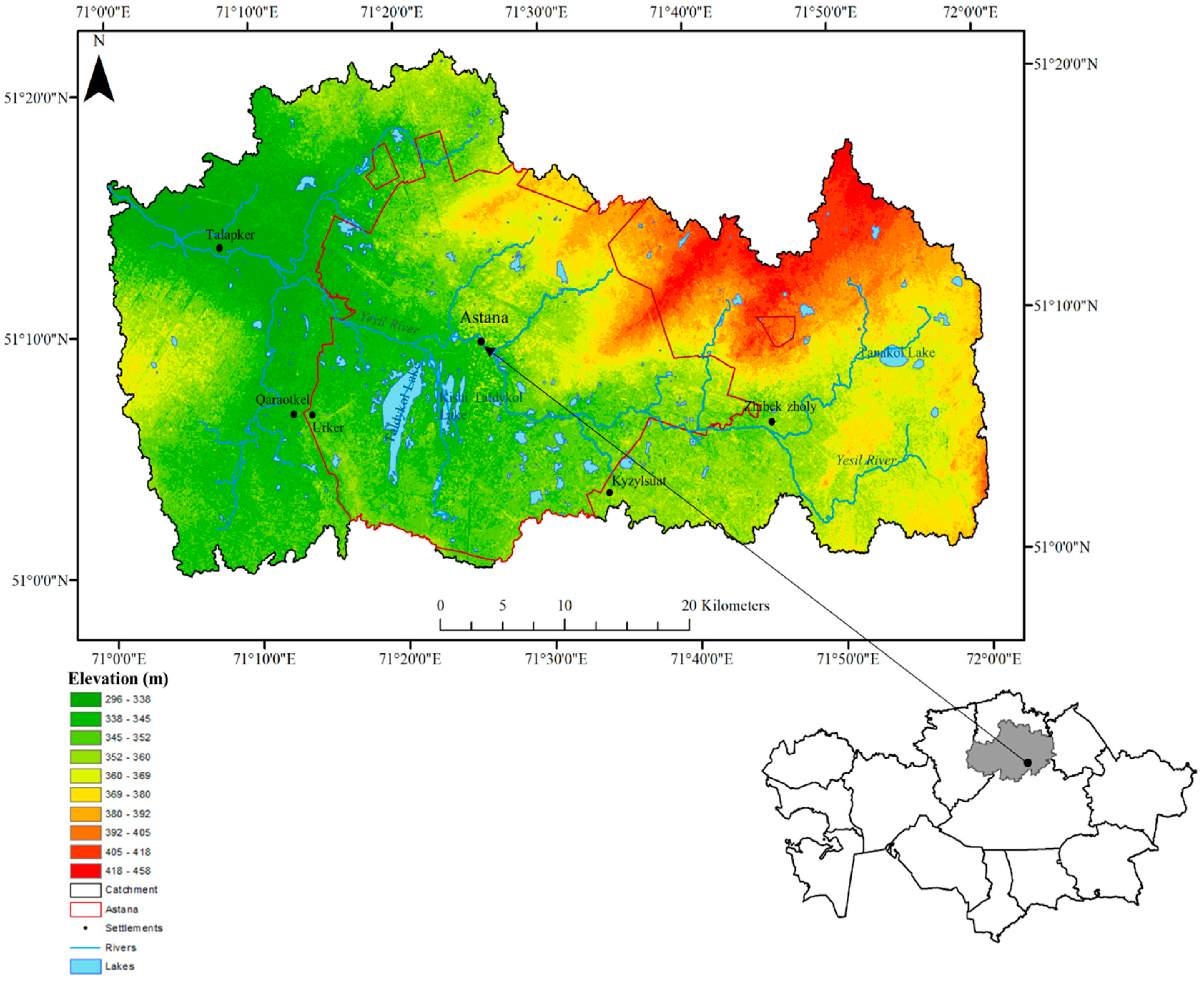
2.1. Study Area

The Taldykol catchment is situated in Northern Kazakhstan, predominantly within the arid steppe region, (elevation of 347 m a.s.l). It is situated on the boundary between the Yesil River Basin and the Nura-Sarysu River Basin (Figure 1), with a catchment area of 1934 km2 (Table 1). The water supply of the Taldykol Lake system primarily originates from the Yesil River System within the Yesil River catchment, which encompasses an area of 177,000 km2 and has a total length of 2450 km2. The Yesil River begins in the Niyaz Hills, north of the Kazakh Uplands (Saryarqa), and flows westward through Astana, then through Petropavl and the flat Ishim Steppe, before joining the Irtysh River at Ust-Ishim. The river is mainly fed by snowmelt, leading to high water levels in spring and low levels in summer [49]. The southern part of the catchment is located within the Nura-Sarysu River catchment. This catchment, located entirely within Kazakhstan’s borders, covers an area of 276,600 km2.

2.2. Data Sources and Preparation

A Shuttle Radar Topography Mission Digital Elevation Model (SRTM DEM) with a 30 m resolution was used to delineate the Taldykol catchment boundaries using ArcMap 10.7. The produced shapefile was then used to assess land cover changes. To evaluate changes in lake area and land cover within the Taldykol catchment spanning the past three decades, we obtained Landsat images from 1992 (TM), 2002 (ETM), and 2010 (TM) from the United States Geological Survey (Table 2). These were selected at 10-year intervals (each in the month of June), except for the Landsat 2010 TM, for which the month of September was chosen based on image availability and atmospheric conditions during capture. Subsequent to data acquisition, atmospheric and radiometric corrections were performed using ArcMap 10.7. For the assessment of the lake’s catchment in the current study, Sentinel-2 imagery from the European Space Agency’s (ESA) Copernicus program was selected in 2022 due to its higher resolution and avoidance of surface reflectance is-sues associated with Landsat 8 OLI, which resulted in non-physical values over bright surfaces and water bodies. The dataset employed in this research comprises the standard Sentinel-2 Level-1C product, downloaded from the ESA Sentinel-2 Pre-Operations Hub (https://scihub.copernicus.eu/, (accessed on 2 July 2024)). Additionally, average annual temperature and total annual precipitation data from the Aqmola weather station (51°13′ N, 71°36′ E; station code: 351880) were obtained from an open-source database (https://en.tutiempo.net/climate/ws-351880.html, (accessed on 2 July 2024)).

3. Methodology

3.1. Development of LULC Classification

This study investigates environmental change over a 30-year period to comprehend human effects on the Taldykol catchment’s environment and their implications for regional development. LULC classification was assessed based on the Anderson and Hardy [51] land use classification system. In this study, the following five categories were identified: water, urban, vegetation, grassland and barren; these categories are explained in Table 3.
It should be noted that barren lands include transitional areas that occur during land use changes, such as clearing forests for agriculture, draining wetlands for development, or when land becomes temporarily bare due to planned constructions (e.g., residences, industrial sites) [51]. It also includes land altered by filling, such as spoil dumps or sanitary landfills. Additionally, due to simplifications in the classification process and the reduction in land cover types, the proportion of agricultural lands was assessed as grasslands and barren lands. Specifically, agriculture areas with grown vegetation were classified as “grasslands”, and unused areas were classified as “barren”.
Our model was designed based on the steps outlined in Figure 2. We assessed land cover alterations through supervised image classification, along with quantitative analysis using spectral indices in ArcMap 10.7.

3.2. Spectral Indices

Landsat and Sentinel products are commonly used to analyze the Earth’s surface by deriving spectral indices, which provide valuable information about long-term changes in land cover [42,52]. Despite their high spatial resolutions, these products have low resolutions, leading recent research to advocate using hyperspectral videos in Earth monitoring due to their superior detail in object movement and material composition [53]. In this study, we aimed to derive three spectral indices from Landsat and Sentinel imagery to reconstruct a long-term changes in LULC in the Taldykol catchment area.
A spectral index refers to a single value obtained through a mathematical operation (e.g., ratio, subtraction, or normalized difference) involving two or more spectral bands. Following this calculation, a suitable threshold for the index is determined to distinguish a certain land cover type from other land cover features based on their spectral attributes. An example of such an index is the normalized difference water index (NDWI) devel-oped by McFeeters [54], which is specifically designed to enhance the reflectance of water bodies in the green band while minimizing the reflectance in the NIR band. However, the main drawback of the NDWI is its limited ability to effectively reduce signal noise originating from built-up land cover features [40,55]. Alternatively, the modified normalized difference water index (MNDWI) [55] substitutes the NIR band of the NDWI with the Shortwave Infrared (SWIR) band. Numerous studies have consistently demonstrated that the MNDWI is better suited for urbanized regions and offers improved accuracy compared to the NDWI [42,56,57]. Considering the location of the Taldykol catchment within the rapidly expanding urban area of Astana, the MNDWI was utilized for the detection of water bodies. The MNDWI was calculated as follows:
MNDWI = ρ G r e e n ρ S W I R ρ G r e e n + ρ S W I R
where ρ G r e e n is the TOA reflectance value of the green band (band 2), and ρ S W I R is the TOA reflectance of the SWIR band (band 5) for both Landsat TM and Landsat ETM. Sentinel-2 offers 20 m resolution for the ρ S W I R band. To maintain the integrity of spatial resolution, the ρ S W I R band was upscaled to a 10 m resolution, as proposed by Du et al. [58], providing a 10 m resolution MNDWI estimated as follows:
MNDWI Sentinel 2 = ρ G r e e n ρ S W I R 10 m ρ G r e e n + ρ S W I R 10 m
where ρ G r e e n is the TOA reflectance value of the green band (band 3) and ρ S W I R 10 m is produced by resampling the original 20 m ρ S W I R 10 m (band 11) using the nearest neighbor method.
MNDWI values range from −1 to 1, where positive values indicate the presence of water, while negative values indicate vegetation, barren, and urban areas (Du, 2016) [56]. To extract water bodies, a threshold for the MNDWI should be defined. After several tests and observations, the thresholds were established. MNDWI values indicating the presence of water ranged from 0 to 0.51 in 1992, from 0 to 0.8 in 2002, and from 0 to 0.27 in 2010, while MNDWI Sentinel 2 values ranged between 0 and 0.83.
The vegetation cover was assessed using the normalized difference vegetation index (NDVI) [58], which is the most common spectral index for monitoring vegetation cover changes. The NDVI was estimated as follows:
NDVI = ρ N I R ρ R e d ρ N I R + ρ R e d
where ρ N I R is the TOA reflectance value of the near-infrared spectrum (band 4 for Landsat TM and ETM; band 8 for Sentinel 2), and ρ R e d is the TOA reflectance value of the red range spectrum (band 3 4 for Landsat TM and ETM; band 4 for Sentinel 2). NDVI values range from −1 to 1, where negative values indicate water bodies, while values from −0.1 to 0.1 indicate barren lands [59], values between 0.2 and 0.4 indicate the presence of grassland [60], and values greater than 0.4 indicate dense green vegetation, as recommended by [61].
Urban areas were assessed using supervised classification, as both NDVI and MNDWI indices are inaccurate for evaluating urban areas for Landsat imagery [40]. For Sentinel-2, which we used for land cover analysis in 2022, urban and barren areas were estimated using the normalized difference tillage index (NDTI) proposed by Van Deventer and Ward [62]. Recent studies showed that the efficiency of the NDTI for Sentinel-2 improves the mapping accuracy in terms of separating urban and barren areas from other land cover types [63,64]. The NDTI was estimated as follows:
NDTI = ρ S W I R 1 ρ S W I R 2 ρ S W I R 1 + ρ S W I R 2
where ρ S W I R 1 is the TOA reflectance of the SWIR 1 (band 11), and ρ S W I R 2 is the TOA reflectance of the SWIR 2 (band 12). The NDTI values range from −0.43 to 0.28 for the Taldykol catchment, where values between 0 and 0.045 indicate urban areas and values greater than 0.046 indicate barren areas.

3.3. LULC Change Analysis

LULC change analysis is essential for illustrating the extent of changes occurring in each LULC type during specific time intervals. The four gridded LULC maps were used to detect the internal variations in LULC in Taldykol region over three periods: from 1992 to 2002, from 2002 to 2010, and from 2010 to 2022. For each pair of gridded datasets, a change matrix was constructed. Percentage variations in individual LULC categories ( C H i ) were calculated to describe the magnitude of changes occurring between time periods using Equation (5), as documented by Long and Liu [65] and Long and Heilig [66]:
C H i = A 2 A 1 A 1 × 100
where A 1 and A 2 are class areas of an LULC (km2) in year 1 and year 2, respectively.
Additionally, for each LULC type, the percentage of ‘conversion loss to’ or ‘conversion gain from’ was computed relative to the overall ‘loss or gain’ conversion of that LULC type, as specified in Equation (6):
P l o s s i , j = p j , i p i , j p i . p . i × 100 ,           i j P g a i n i , j = p i , j p j , i p i . p . i × 100 ,           i j
where P l o s s i , j represents the percentage that LULC class j contributes to the overall “conversion loss” in row i , P g a i n i , j is the percentage that class j contributes to the total “conversion gain” in row i , p i , j and p j , i refer to the individual entries in a specific change matrix, while p i . represents the column total of class i , and p . i is the row total for class i .

3.4. Classification Accuracy Assessment

An accuracy assessment was conducted to quantitatively evaluate the outcomes of LULC classification. The sample design and sample size were determined based on the recommendations of Hord and Brooner [67], Fitzpatrick-Lins [68], and Hay [69]. This approach remains widely adopted in contemporary research [70]. These studies recommended utilizing stratified sampling with a minimum sample size of 50 points per class. As a result, a total of 250 random points were generated for our analysis, with each class examined separately using the polygons generated by each corresponding class from LULC classification. The accuracy was assessed by comparing the LULC classification map at a given point with the reference image provided by Google Earth. It should be noted that the accuracy assessment was only accomplished for LULC classification in 2022, and it does not evaluate the accuracy of change detection, which is outside the scope of this article but may be further evaluated, as suggested by Zhou et al. [71].
Further accuracy assessment analysis involved establishing an error matrix based on the produced classification map and a reference image (Google Earth), including the estimation of overall accuracy and the Kappa analysis. The overall accuracy was estimated as follows:
O v e r a l l   a c c u r a c y = N u m b e r   o f   c o r r e c t   p o i n t s T o t a l   n u m b e r   o f   p o i n t s
Kappa analysis is a discrete multivariate technique employed in accuracy assessments [72], which generates a Khat statistic (an estimate of kappa), providing a measure of agreement or accuracy [73]. Kappa analysis was estimated as follows:
K = N i = 1 r x i i i = 1 r ( x i + X x + 1 ) N 2 i = 1 r ( x i i X x + 1 )

3.5. Land Surface Temperature Retrieval

Land surface temperature (LST) retrieval analysis for Taldykol catchment was based on a single-window algorithm proposed by Sobrino an Jiménez-Muñoz [74] and Avdan and Jovanovska [75], utilizing just one thermal infrared band derived from Landsat data. In this study, Landsat 5 was used for LST retrieval in 1992, and Landsat 8 was used for 2022, representing the end of June for the corresponding years (Table 1). The LST retrieval process consists of a series of steps. Initially, the thermal infrared band underwent radiometric calibration, where the digital number (DN) value was translated into its corresponding radiation intensity value L λ (L6/L10). Subsequently, this value was converted into the corresponding radiation brightness temperature value T a (T6/T10). Here, L6/L10 refers to the radiation intensities of band 6 for Landsat 5 TM and band 10 for Landsat 8 OLI, with the same convention applying to T6/T10. Equations (9) and (10) detail this process:
L λ = G × D N + B
T a = K 2 l n l n   ( 1 + K 1 L λ )   273.15
where G is gain parameter, and B is bias parameter, and these two parameters derived from the MLT file. K 1 and K 2 are the band-specific thermal conversion constants.
Then, using NDVI values, the land surface emissivity was estimated using the following equations:
P v = ( N D V I N D V I s N D V I v N D V I s ) 2
E = 0.004 × P v + 0.986
where P v is the proportion of vegetation, N D V I s is the minimum DN values from the NDVI, N D V I v is the maximum DN values from the NDVI, and E is the land surface emissivity.

4. Results

4.1. Accuracy Assessment of LULC

The mean overall accuracy, as indicated in Table 4, is 0.87, and the kappa coefficient is 0.84. According to the Kappa statistics criteria, the agreement is considered fair when K < 0.4, moderate when 0.41 < K < 0.6, substantial when 0.61 < K < 0.8, and almost perfect when K > 0.81 [76]. Therefore, the LULC classification for the catchment in 2022 indicates almost perfect agreement between the observed and classified values. Overall accuracy per each classification class showed the highest accuracy for grassland and water (0.96 and 0.92, respectively). The lowest accuracy was observed for urban areas (0.76), where the error matrix indicated misclassification between urban and grassland areas, particularly those located within the urbanized zones.

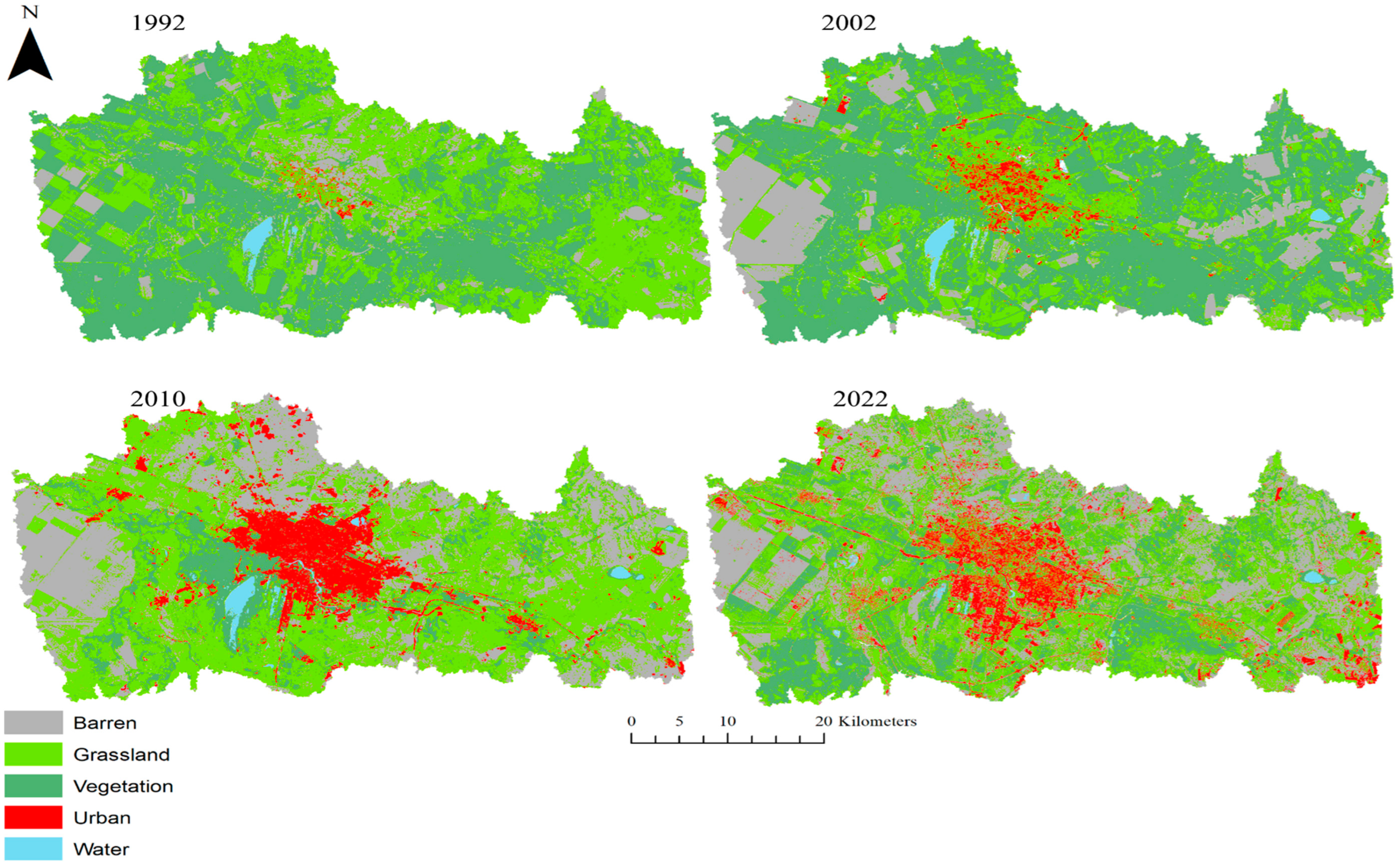
4.2. Changes in LULC Types

Table 5 shows a summary of the extent and proportion of each LULC type during the following four time periods: 1992, 2002, 2010, and 2022. The LULC classification for 1992 indicates that the majority of the study area primarily comprised natural areas, with an almost equal distribution between grassland and vegetated areas (47% and 44%, respectively). Since 2002, the proportion of barren areas has steadily increased, expanding from 77 km2 in 1992 to 299 km2 in 2002, reaching its maximum area in 2022 with an area of 610 km2. The most significant reduction within the LULC type occurred in vegetated areas. Between 1992 and 2002, vegetated areas increased, reaching over 50% coverage of the area. However, the vegetated areas underwent an overall decrease from 990 km2 in 1992 to a minimum of 222 km2 in 2010, comprising 11% of the Taldykol catchment. Although the proportion of vegetated areas increased to 19% in 2022, it could not fully recover to its proportions in 1992. By 2022, the predominant land cover in the study area comprised grassland (38%) and barren areas (32%).
Through the analysis of the LULC change, it is evident that among the five types, barren and urban areas exhibit continuous expansion (Table 6). From 1992 to 2010, the expansion of both barren and urban areas persisted, with the most notable increase in barren lands occurring by 2002 (around 288%), and for urban areas, it was between 2002 and 2010 (56%). The change matrix shows that the expansion in barren lands occurred due to a decrease in vegetation and grasslands, while urban area expansion occurred due to conversion from grassland and vegetation areas (Table A1 in Appendix A). It should be noted that the small increase in urban areas between 2010 and 2022 (Table 5) could be an artifact of the overestimation of urban areas in 2010 due to the lower resolution of Landsat5 used for that year compared to Sentunel-2 used for 2022.
The most notable decrease among the five LULC types occurred in the proportion of vegetation, as vegetated areas decreased significantly to 768 km2, representing a 78% reduction by 2010. Although Figure 3 shows an increase in vegetated areas from 1992 and 2002 and then from 2010 to 2022, the overall proportion of the vegetated areas decreased by 263% during the study period. Most of the reduction in vegetated areas occurred due to conversion to grassland and barren areas by 2010 (Table A1).
In addition to vegetation, the water areas in the Taldykol catchment experienced a decrease. The total proportional change in water areas was more than 24% (Table 6). The most remarkable changes within the water areas occurred between 2010 and 2022, resulting in a decrease of approximately 4 km2, as most of the water areas were converted to urban and vegetated areas.

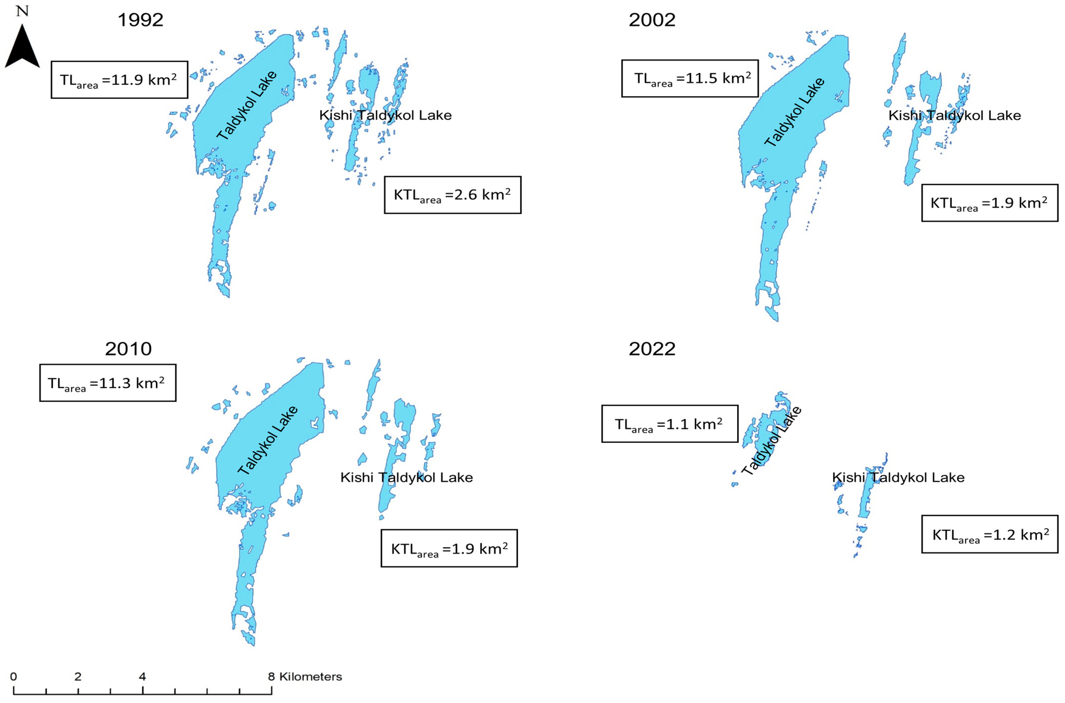
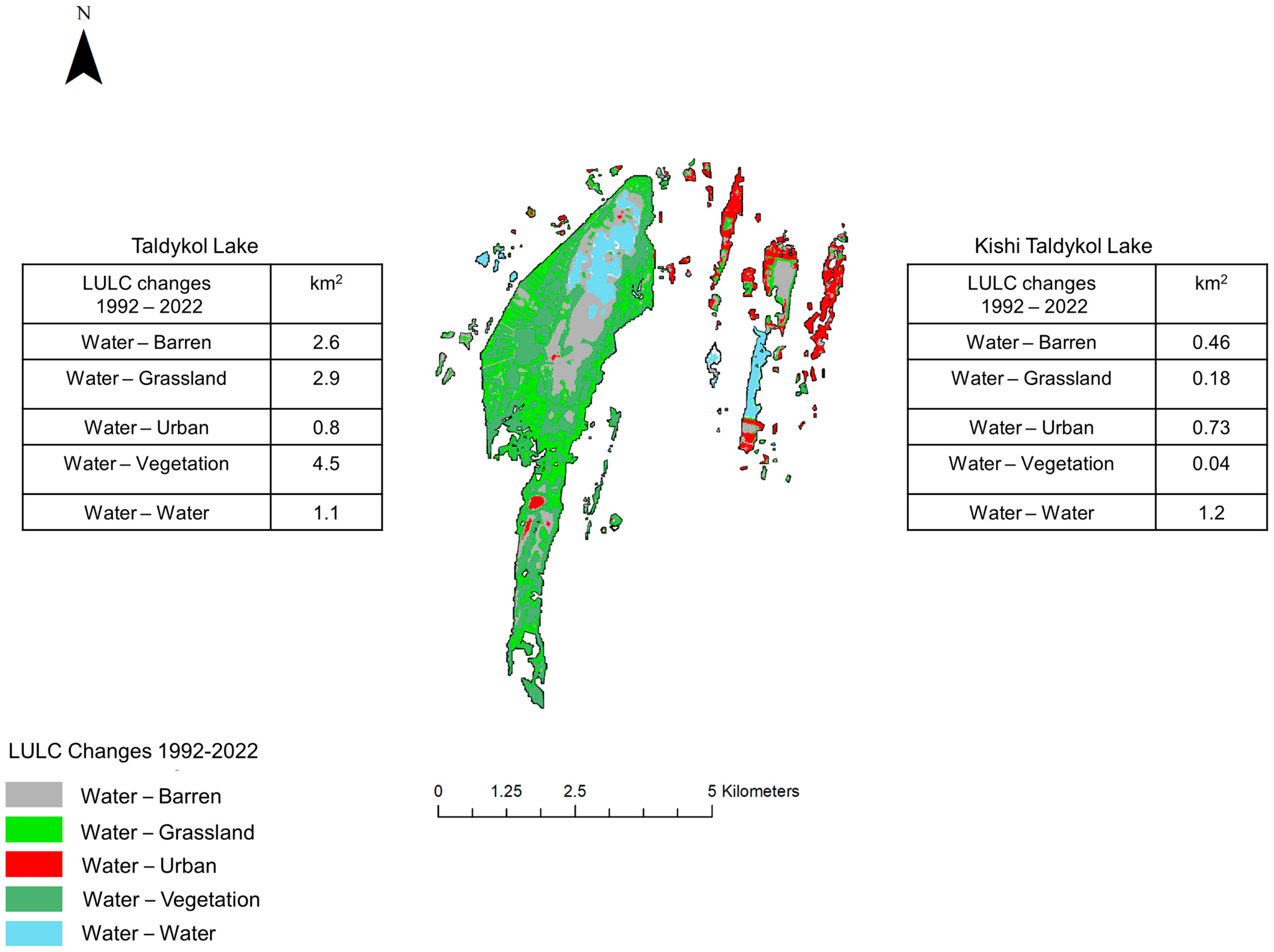
4.3. Changes in Taldykol Lakes

Figure 4 shows significant decreases in the areas of both Taldykol and Kishi Taldykol lakes by respective figures of 91% and 54% from 1992 to 2022. Taldykol Lake exhibited negligible reduction between 1992 and 2010 (from 11.9 km2 to 11.5 km2), followed up by a substantial reduction from 11.3 km2 to 1.1 km2 between 2010 and 2022, resulting in an overall reduction of 91%. In contrast, Kishi Taldykol Lake experienced a decrease from 2.6 km2 to 1.9 km2 between 1992 and 2002, followed by another reduction between 2010 and 2022, resulting in the overall lake area being less than 1.2 km2.
Figure 5 illustrates that the former Taldykol Lake areas were primarily converted to vegetation (41.7%) and grassland (26.9%), while the areas of Kishi Taldykol Lake were converted to urban areas (52.1%) and barren areas (32.9%) from 1992 to 2022.

4.4. LST and LULC Changes

Figure 6 shows the LST map derived for the end of June for both 1992 and 2022. Due to the absence of measured LST, air temperature data from the Aqmola weather station were used for validation. The recorded air temperatures in the Taldykol area were 13.5 °C, 29.1 °C, and 22.4 °C for the lowest, highest, and average temperatures, respectively, in 1992 and 9.3 °C, 25.9 °C, and 18.7 °C in 2022. According to the LST retrieval for 1992, the temperature varied from 18 °C and 41 °C, with a mean temperature of 31 °C and a standard deviation of 3.8 °C. In 2022, the temperature ranged from 3 °C and 48 °C, with a mean of 29 °C and a standard deviation of 3.0 °C.
The spatial distribution of the LST indicated higher values in the northern, northwestern, and western areas of the study area, which are characterized by barren and grassland (Figure 6a). Lower LST values were observed in the central regions of the catchment and the southwest areas, dominated by water bodies and rivers (Yesil River), and vegetated areas. Based on the LST change map (Figure 6c), positive changes were observed in the south, while negative changes were observed in the north.
The single-factor ANOVA test results showed no statistical difference in mean temperatures among selected LULC types across the two time periods (p = 0.83). However, the variance in LST among LULC types was substantially higher in 1992 compared to 2022 (Figure 7). The lowest median temperatures among the selected LUCL types were found in water bodies and vegetation for both 1992 and 2022 (Table A3), with the lowest mean LTS found in water class (Table A2). The highest medians were observed in barren land (32.5 °C) in 1992 and urban areas (30 °C) in 2022. Notably, the LST of water bodies showed the highest increases in both median (from 23.7 °C to 25.5 °C) and maximum (32.9 °C and 36.2 °C) values among LULC classes between 1992 and 2022. Another increase in median LST was observed in urban and grassland classes (less than 0.5 °C). Additionally, narrower variations were noted in urban and barren classes in 2022, with the vegetation class showing the lowest variations. A decrease in mean temperature was established for the remaining LULC types, with the largest decreases observed in barren and vegetation areas, being −2.6 °C and −2.4 °C, respectively. The statistics are shown in Table A2 and Table A3 in Appendix B.

4.5. LST and Changes in the NDVI and MNDWI

The relationship between remote sensing indices and LST was examined using a pixel-by-pixel correlation analysis. Pearson’s correlation showed that both the NDVI and MNDWI indexes were significantly correlated with the LST (Figure 8, p < 0.01). NDVI values in the study areas ranged from −0.9 to 0.72 in 1992 and from −0.5 to 0.72 in 2022, whereas MNDWI values varied from −0.69 to 0.51 in 1992 and from −0.65 to 0.45 in 2022. Figure 8 shows the relationship between the LST and NDVI changes in the Taldykol catchment from 1992 to 2022. The correlation analysis indicates a moderate statistically significant negative relationship between the LST and NDVI in both 1992 (r = −0.58, p < 0.01, n = 261) and 2022 (r = −0.51, p < 0.01, n = 261). However, low determination coefficients (R2 = 0.34 and R2 = 0.27 in 1992 and 2022, respectively) indicate that the relationship between the LST and NDVI cannot be adequately explained by a linear model alone and requires further investigation in future research. The heterogeneous characteristics of the land surface could lead to greater variability in LST values, particularly in areas with low vegetation cover. For instance, pixels with similar levels of vegetation might exhibit different LSTs due to the variations in factors such as soil moisture conditions, vegetation conditions, etc. [46,77].
The correlation analysis revealed a moderate, statistically significant negative relationship between LST and the MNDWI in 1992 (r = −0.54, p < 0.001, n = 261). However, by 2022, this relationship reversed, becoming moderately positive (r = 0.42, p < 0.001, n = 261) (Figure 8c,d). Similar to the analysis with the NDVI, the low determination coefficients show that the relationship between LST and the MNDWI cannot be fully explained by a linear model. For waterbodies, LST represents the water surface temperature, which decreases linearly as the MNDWI values increase. This suggests that higher MNDWI values have a greater potential cooling effect on LST. The low determination coefficients (R2 = 0.30 and R2 = 0.18 in 1992 and 2022, respectively) might be influenced by the sparse coverage of water bodies within the study area, while the reversal in the relationship between the MNDWI and LST could be attributed to the early or late arrival of the spring season, leading to variations in water surface temperature [78]. The underlying factors for this should be explored further in future research.

5. Discussion

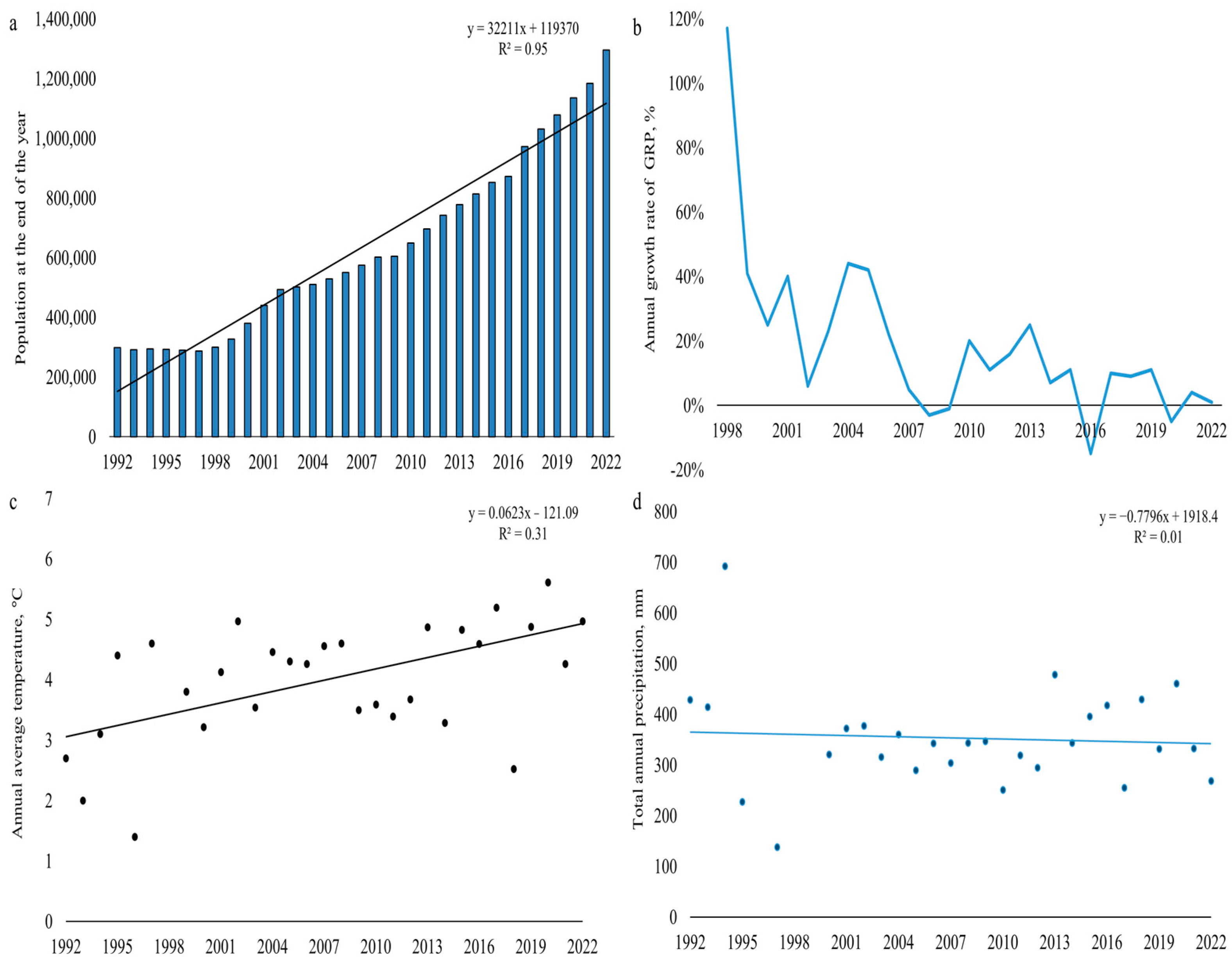
5.1. Effects of Anthropogenic Impact on LULC

Rapid change in LULC types has occurred in the Taldykol catchment during the past 30 years. Our study shows that since the establishment of the capital city in the study area, the composition of LULC has shifted from natural areas, with an almost equal distribution between grassland (47%) and vegetation (44%) in 1992, to more urbanized and industrialized areas. The largest reductions occurred in vegetation (−56%) and water areas (−24%), while there were dramatic increases in barren (637%) and urban areas (127%).
According to Bureau of National Statistics, the city’s population was around 298,000 in 1992, reaching 1.3 million by 2022 (Figure 9a) [79]. Since Astana became the capital city in 1997, its economy has grown at an annual rate of 19% (Figure 9b). This rapid population increase and expansion of economic activity were accompanied by accelerated urbanization, resulting in the expansion of urban areas and an increase in barren areas between 1992 and 2022. The subsequent urbanization and expansion of Astana have affected natural areas, with the greatest reductions observed in vegetation. Our findings indicate a significant reduction in vegetation, approximately −78% between 2002 and 2010, coinciding with a period of rapid development in Astana, and a subsequent rapid increase in population. However, this decreasing pattern has been reversed, with vegetated areas increasing by 69% (154 km2) during 2010–2022.
The expansion of vegetated areas is likely to be linked to governmental efforts to establish a ‘green belt’ encircling Astana, initiated in 1997. This initiative aimed to enhance the city’s environment by reducing wind load, enhancing air quality, and reducing dust pollution within urban areas [80]. Between 1997 and 2011, within the framework of this initiative, 60 km2 out of a targeted 100 km2 of vegetated areas were created, despite difficulties related to the arid climate and complex soil salinization [81]. Our analysis captures the effect of this ‘green belt’, highlighting an increase in vegetation between 2010 and 2022. However, despite the implementation of this initiative in Astana, our findings suggest that vegetation areas have not fully recovered following the city’s expansion and accounted for only 19% of the total area of the Taldykol catchment by 2022.
In addition to economic considerations, it was essential to assess changes in air temperature and precipitation patterns in Astana. The Mann–Kendall (MK) trend analysis of average annual temperature showed a statistically significant upward trend (z = 3.358, p < 0.05, tau = 0.42, Sen’s slope = 0.065) from 1992 to 2022 (Figure 9c). The mean temperature during this period was 4.0 °C, with standard deviation of 1.1 °C. The highest temperature recorded was recorded in 2020 (5.6 °C), while the lowest was 1.4 °C in 1996.
In contrast, the MK analysis of the total annual precipitation in Astana indicated no significant trend from 1992 to 2022 (z = 0.535, p = 0.59, tau = 6.85) (Figure 9d). The mean annual precipitation during this period was 348 mm, with standard deviation of 94 mm. The highest recorded precipitation was 692 mm in 1994, and the lowest was 138 mm in 1997.
The correlation analysis between LST and the NDVI indicates a significant negative relationship; however, this relationship cannot be fully captured by a linear model due to the heterogeneous characteristics of the land surface, which may lead to greater variability in LST values. This is likely to be impacted by significant reductions in the vegetated areas from 1992 to 2022, as well as the increase in annual temperature during this period (Figure 9c), which affected soil moisture and vegetation conditions. Similar findings were observed in Guangzhou, China, where the relationship between LST values and the percentage of vegetation abundance and impervious surface was not straightforward due to variance in soil moisture and vegetation conditions [77].
The spatial variations in LST indicate a positive LST response in the southern part of the study area, corresponding to the direction of Astana’s development. Similar findings were established within the Galle Municipal Council area in Sri Lanka, where the most significant variation in LST (5.5 °C) occurred in newly developed urban areas, formerly covered by vegetation land [82]. The 20-year analysis of LST variation in rural and urban areas in Samsun, Turkey, showed a 14% decrease in vegetated areas, equally shared between urban areas and barren lands, which increased the maximum LST values from 41.7 °C to 43.4 °C [83]. Similar to our findings, the correlation strength between the NDVI and LST in urban districts diminished due to the heterogeneous land surface cover. Further analysis of the annual and seasonal LST variations and their relationships with the NDVI and the NDBI in the area would be beneficial for evaluating the impact of Astana’s urban expansion and vegetation loss on LST response.

5.2. Anthropogenic Impact on Taldykol and Kishi Taldykol Lakes

Over the last decades, there has been an increasing focus on wetland conservation initiatives, such as restoration and establishment, particularly in developed countries [84,85,86]. Our findings indicate that the second most reduced LULC type was water areas, with a reduction of 24%. This reduction was primarily driven by the drying up of Taldykol and Kishi Taldykol lakes between 2010 and 2022, which experienced decreases of 91% and 54%, respectively. This significant decline in water areas is evidently associated with anthropogenic impact resulting from the rapid development of Astana, particularly in the southern regions of the study area. Our findings show that the former Kishi Taldykol area has predominantly been transformed into urban (52%) and barren areas (32.9%), with barren areas likely to be further developed for built-up purposes. Interestingly, Taldykol Lake area is less utilized for urban expansion (7.4%), although the lake area diminished by 91% between 1992 and 2022. The shallowing of Taldykol Lake could be influenced by construction activities, including the development of transportation networks (roads) and the increase in impervious surfaces, within the lake catchment, which negatively impact urban wetlands through hydrologic isolation [87]. The degradation and loss of urban wetlands pose significant challenges to the sustainable urban environment, especially in developing countries. Similar, urban wetland loss due to urbanization was identified in the eastern regions of China, with almost 2883 km2 lost from 1990 to 2010 [13]. A recent study showed that the rapid expansion of built-up areas in Bolgoda, Sri Lanka, from 1989 to 2021, leading to a 78% loss of wetlands, decreased the overall ecosystem service value (ESV) by an equivalent of USD 116 million per year [88]. Analysis of changes in LULC types from 1991 to 2018 in the Chatra wetland in India revealed a 60% decrease in wetland areas, resulting in a 71.9% reduction in the ESV value over this period [89]. The depletion of urban wetlands from 70 km2 to 29 km2 in Kumasi, Ghana, led to frequent flooding events and had negative implications for wetland species [90].
Early approaches to wetland management, which continue to shape modern attitudes, were based on the misconception that wetlands were unproductive areas to be avoided or, when feasible, drained and reclaimed for alternative land uses [1]. However, contemporary thinking highlight the role of wetlands in the context of urban sustainability and climate change, reducing the effect of urban heat islands, reducing flooding risks [91,92,93]. The management of the Taldykol system was variable and controversial. The Taldykol Lake system served as a site for evaporation and wastewater collection from 1970 to 2015 [94], where treated wastewater was consistently released into the lakes on a daily basis, effectively serving as a reservoir for wastewater. The initial master plan for Astana aimed to convert the Taldykol area into a green zone featuring recreation parks. However, in 2020, city authorities decided to develop residential and social infrastructure on the land of Kishi Taldykol Lake. Consequently, Kishi Taldykol Lake lost its ‘lake’ status and was transferred to an urban area category, and the backfilling process was initiated.
Recent research emphasized the significance of the Taldykol wetlands for urban planning, highlighting that preserving their natural state is more cost-effective than trying to recreate their ecological services [25]. The backfilling of Taldykol wetlands was deemed counterproductive for urban management, exacerbating environmental issues and accelerating negative impacts linked to wetland loss. The anthropogenic disturbances to natural areas and the rapid population growth of Astana have already impacted the urban environment. Recent studies on air pollution showed that Astana is among the most polluted cities (PM2.5 concentrations) in the world during winter time, which might be linked to higher energy demand for heating requirements [95].
Wetlands often contribute to the hydrologic cycle by enhancing streamflow, recharging groundwater, providing water supplies, and offering flood protection [96,97,98]. Certain wetlands are protected for their capacity to retain water and gradually release it into surface-water and groundwater systems during periods of low water [1,99]. Conversely, if wetlands are flooded, they retain additional water and prevent downstream flooding [91,100]. Figure 9d shows that precipitation experienced no statistically significant change from 1992 to 2022. However, future climate models suggests a large intensification of extreme precipitation in this region [101,102,103]. During summer of 2023, the Astana Utilities Company practiced rolling shutdowns of municipal water supplies due to water shortages. The Astana city administration explained the situation by the rapid increase in the city’s population and high rate of completion of new residential housing. In less than a year, during spring of 2024, northern parts of Kazakhstan were subject to unprecedented flooding that damaged housing and infrastructure and halted agriculture and industrial production. These floods required the evacuation of over 100,000 people and declaration of a state of emergency in parts of Northern Kazakhstan.
The role of the Taldykol Lake system in the regional hydrological cycle remains largely unknown, as not all wetlands perform hydrological functions effectively [1]. Developing a hydrological model to explain surface-water and groundwater interactions in the Taldykol Lake system would clarify the roles of these lakes, particularly in addressing future climate change extremes. This is important as future climate models suggest increasing water variability, with extended periods of drought and, conversely, periods of increased precipitation [104,105], posing greater challenges for urban sustainability and water resource availability in Kazakhstan [106]. The changing climate might also exacerbate the negative effects of urbanization, such as increased urban temperatures and flooding [107].
With the further development and ongoing urbanization of Astana, the integration of green and blue infrastructure would benefit adaptation to and the mitigation of the consequences of severe weather conditions (heat waves, floods, and droughts). The disappearance of the Taldykol lakes has led to biodiversity loss and a reduction in the functions and services that urban ecosystems provide. However, urban green and blue infrastructure can alleviate these pressures by offering habitats for diverse species [108], delivering various environmental and cultural benefits, and contributing to climate change adaptation and mitigation [109].
Wetlands are fragile ecosystems worldwide, and the uncertainty surrounding fluctuating water resources is further intensified by global warming and rapid urbanization [110,111]. The case of Taldykol Lake shows that Kazakhstani wetlands are particularly vulnerable to shallowing due to rapid and unplanned urbanization and a lack of understanding of wetlands’ roles in urban environment. Our findings contribute to the evaluation of long-term changes in the urban wetlands of Kazakhstan, which remain overlooked in contemporary research. Given that ecosystem services in Central Asia are diminishing, particularly in terms of biodiversity, water, and soil conservation [112], it is essential to evaluate the long-term changes in wetlands located in Kazakhstan, as well as their roles in the hydrological cycle and ecosystem services.

6. Conclusions

A significant reduction in the area of the two lakes in Astana, documented by our study, may have long-lasting consequences for the city. The near disappearance of the Taldykol wetlands is likely to have an effect on city amenities in the form of rising urban temperature, decreased capacity of natural flood control, reduced numbers of migrating birds and other forms of biodiversity, and fewer opportunities for recreation. The fate of the Taldykol lakes underscores the urgent need to raise public awareness of wetlands’ role in Kazakhstan’s ecosystems and take action to preserve urban wetlands.
Our study is the first study on the fate of urban wetlands in Kazakhstan. By analyzing Earth observation data using ArcMap 10.7, we identified spatiotemporal changes in LULC in the Taldykol catchment. This allowed us to document how the expansion of built-up areas in Astana over a period of 30 years was accompanied by a drastic reduction in urban wetlands. We used Astana as a case study; however, other cities in Kazakhstan may produce similar damaging impacts on wetlands. As a result, further research in this direction is necessary to raise the awareness of city planners, businesses, and residents in order to identify wetland-friendly paths for urban development.
The LULC analysis was conducted based on five classes, excluding the evaluation of agricultural and industrial areas within the study period. Consequently, the proportion of grassland and barren areas, as well as changes within these LULC classes, might differ with the introduction of agriculture and industrial classes into the analysis. Further LULC analysis incorporating additional classes for artificial surfaces would provide a more in-depth examination of anthropogenic disturbances and their implications for natural areas (e.g., water and vegetation) in Astana. Moreover, annual and intra-annual variability in land cover types between 2010 and 2022 need to be examined, as our findings indicate that major changes occurred in the Taldykkol lakes during this period.

Author Contributions

Conceptualization, M.B. and Z.A.; methodology, M.B.; software, M.B. and A.K; validation, M.B. and A.K.; formal analysis, M.B. and Z.A.; investigation, M.B. and A.K.; resources, M.B.; data curation, A.K. and M.B.; writing—original draft preparation, M.B. and A.K.; writing—review and editing, Z.A.; visualization, M.B. and A.K.; supervision, M.B.; project administration, M.B.; funding acquisition, M.B. All authors have read and agreed to the published version of the manuscript.

Funding

The Article Processing Charge was funded by the Nazarbayev University Social Policy Grant (Grant number 064.01.00).

Institutional Review Board Statement

Not applicable.

Informed Consent Statement

Not applicable.

Data Availability Statement

The Kazakhstan Bureau of National Statistics website at https://stat.gov.kz/en/ (accessed on 15 March 2024).

Acknowledgments

The authors wish to thank the anonymous reviewers for their constructive comments, which helped to improve the manuscript.

Conflicts of Interest

The authors declare no conflicts of interest.

Appendix A

Table A1. Transition area matrix (km2) between 1992, 2002, 2010, and 2022 in the Taldykol catchment.
LULC 2002 (km2)LULC 1992 (km2)Changes in 1992–2002
LULC typeBarrenVegetationGrasslandUrbanWaterTotalkm2%
Barren28.610.722.914.90.077.0222.0288
Vegetation146.8556.5138.73.00.8845.0144.817
Grassland121.0421.0339.019.62.0902.6−401.6−44.5
Urban0.00.00.085.80.085.837.243
Water2.61.70.70.118.523.6−2.2−9
Total299.0989.8501.0123.021.41934--
LULC 2010 (km2)LULC 2002 (km2)Changes in 2002–2010
BarrenVegetationGrasslandUrbanWaterTotalkm2%
Barren152.67.6130.95.71.7299274.392
Vegetation216.5148.1571.650.01.0987−765.2−78
Grassland190.038.6188.782.31.5501422.484
Urban13.526.130.852.51.012567.054
Water0.31.51.61.417.7230.31.2
Total572.9222.0923.6192.022.81934--
LULC 2022 (km2)LULC 2010 (km2)Changes in 2010–2022
BarrenVegetationGrasslandUrbanWaterTotalkm2%
Barren34430.2151.245.81.7573.037.06.5
Vegetation16.2121.868.812.52.8222.0154.069.4
Grassland214.0208.6456.142.43.3924.0−189.0−20
Urban34.910.455.088.03.7192.02.01
Water1.585.13.95.27.122.8−4.2−18.3
Total610.0376.0735.0194.018.61934--

Appendix B

Table A2. The mean LST and its standard deviation for different LULC classes, which were calculated by the means of GIS spatial partition statistics.
ClassWaterBarrenUrbanGrasslandVegetation
Mean LST, 1992 (°C)23.831.128.929.531.7
Mean LST, 2022 (°C)27.228.529.928.529.3
Std. deviation, 19922.44.93.23.92.8
Std. deviation, 20223.23.32.63.02.5
Table A3. Box plot statistics for LST across different LULC classes in the Taldykol catchment, where Q1 represents the first quartile (25th percentile) and Q3 represents the third quartile (75th percentile).
LST (°C), 1992
ClassMINQ1MedianQ3Max
Water18.421.923.725.432.9
Barren18.428.832.534.940.3
Urban18.826.729.631.238.4
Grassland18.427.130.032.539.2
Vegetation15.627.828.531.044.5
LST (°C), 2022
Water18.923.925.527.536.2
Barren18.829.129.130.437.0
Urban19.028.430.031.737.2
Grassland18.626.628.730.737.2
Vegetation18.927.228.529.635.5

References

  1. Mitsch, W.; Gosselink, J. Wetlands, 5th ed.; John Wiley & Sons: Hoboken, NJ, USA, 2015. [Google Scholar]
  2. Janse, J.H.; Van Dam, A.A.; Hes, E.M.; de Klein, J.J.; Finlayson, C.M.; Janssen, A.B.; van Wijk, D.; Mooij, W.M.; Verhoeven, J.T. Towards a global model for wetlands ecosystem services. Curr. Opin. Environ. Sustain. 2019, 36, 11–19. [Google Scholar] [CrossRef]
  3. Zhang, X.; Liu, L.; Zhao, T.; Wang, J.; Liu, W.; Chen, X. Global annual wetland dataset at 30 m with a fine classification system from 2000 to 2022. Sci. Data 2024, 11, 310. [Google Scholar] [CrossRef]
  4. Yu, B.; Zang, Y.; Wu, C.; Zhao, Z. Spatiotemporal dynamics of wetlands and their future multi-scenario simulation in the Yellow River Delta, China. J. Environ. Manag. 2024, 353, 120193. [Google Scholar] [CrossRef]
  5. Salimi, S.; Almuktar, S.A.; Scholz, M. Impact of climate change on wetland ecosystems: A critical review of experimental wetlands. J. Environ. Manag. 2021, 286, 112160. [Google Scholar] [CrossRef] [PubMed]
  6. Almuktar, S.A.; Abed, S.N.; Scholz, M. Wetlands for wastewater treatment and subsequent recycling of treated effluent: A review. Environ. Sci. Pollut. Res. 2018, 25, 23595–23623. [Google Scholar] [CrossRef] [PubMed]
  7. Hassan, I.; Chowdhury, S.R.; Prihartato, P.K.; Razzak, S.A. Wastewater treatment using constructed wetland: Current trends and future potential. Processes 2021, 9, 1917. [Google Scholar] [CrossRef]
  8. Whigham, D.F.; Chitterling, C.; Palmer, B. Impacts of freshwater wetlands on water quality: A landscape perspective. Environ. Manag. 1988, 12, 663–671. [Google Scholar] [CrossRef]
  9. Fluet-Chouinard, E.; Stocker, B.D.; Zhang, Z.; Malhotra, A.; Melton, J.R.; Poulter, B.; Kaplan, J.O.; Goldewijk, K.K.; Siebert, S.; Minayeva, T.; et al. Extensive global wetland loss over the past three centuries. Nature 2023, 614, 281–286. [Google Scholar] [CrossRef]
  10. Davidson, N.C. How much wetland has the world lost? Long-term and recent trends in global wetland area. Mar. Freshw. Res. 2014, 65, 934–941. [Google Scholar] [CrossRef]
  11. Xi, Y.; Peng, S.; Ciais, P.; Chen, Y. Future impacts of climate change on inland Ramsar wetlands. Nat. Clim. Chang. 2021, 11, 45–51. [Google Scholar] [CrossRef]
  12. Creed, I.F.; Lane, C.R.; Serran, J.N.; Alexander, L.C.; Basu, N.B.; Calhoun, A.J.; Christensen, J.R.; Cohen, M.J.; Craft, C.; D’Amico, E.; et al. Enhancing protection for vulnerable waters. Nat. Geosci. 2017, 10, 809–815. [Google Scholar] [CrossRef] [PubMed]
  13. Mao, D.; Wang, Z.; Wu, J.; Wu, B.; Zeng, Y.; Song, K.; Yi, K.; Luo, L. China’s wetlands loss to urban expansion. Land Degrad. Dev. 2018, 29, 2644–2657. [Google Scholar] [CrossRef]
  14. Cao, Y.; Ma, Y.; Liu, T.; Li, J.; Zhong, R.; Wang, Z.; Zan, C. Analysis of Spatial–Temporal Variations and Driving Factors of Typical Tail-Reach Wetlands in the Ili-Balkhash Basin, Central Asia. Remote Sens. 2022, 14, 3986. [Google Scholar] [CrossRef]
  15. Ballut-Dajud, G.A.; Sandoval Herazo, L.C.; Fernández-Lambert, G.; Marín-Muñiz, J.L.; López Méndez, M.C.; Betanzo-Torres, E.A. Factors Affecting Wetland Loss: A Review. Land 2022, 11, 434. [Google Scholar] [CrossRef]
  16. Mirzaei, A.; Zibaei, M. Water Conflict Management between Agriculture and Wetland under Climate Change: Application of Economic-Hydrological-Behavioral Modelling. Water Resour. Manag. 2021, 35, 1–21. [Google Scholar] [CrossRef]
  17. An, S.; Tian, Z.; Cai, Y.; Wen, T.; Xu, D.; Jiang, H.; Yao, Z.; Guan, B.; Sheng, S.; Ouyang, Y.; et al. Wetlands of Northeast Asia and High Asia: An overview. Aquat. Sci. 2013, 75, 63–71. [Google Scholar] [CrossRef]
  18. Zan, C.; Liu, T.; Huang, Y.; Bao, A.; Yan, Y.; Ling, Y.; Wang, Z.; Duan, Y. Spatial and temporal variation and driving factors of wetland in the Amu Darya River Delta, Central Asia. Ecol. Indic. 2022, 139, 108898. [Google Scholar] [CrossRef]
  19. Bragina, T.M. The Key Wetlands of the North Kazakhstan; Tethys: Almaty, Kazakhstan, 2000. [Google Scholar]
  20. Ramsar, S. The List of Wetlands of International Importance 2023. Available online: https://www.ramsar.org/sites/default/files/documents/library/info2007-04-e.pdf (accessed on 2 July 2024).
  21. Micklin, P. Aral Sea Basin Water Resources and the Changing Aral Water Balance. In The Aral Sea; Springer: Berlin/Heidelberg, Germany, 2014; pp. 111–135. [Google Scholar]
  22. Petr, T. Lake Balkhash, Kazakhstan. Int. J. Salt Lake Res. 1992, 1, 21–46. [Google Scholar] [CrossRef]
  23. Baigaliyeva, M.; Mount, N.; Gosling, S.N.; McGowan, S. Unravelling long-term impact of water abstraction and climate change on endorheic lakes: A case study of Shortandy Lake in Central Asia. PLoS ONE 2024, 19, e0305721. [Google Scholar] [CrossRef]
  24. Akbayeva, L.K.; Meldeshova, A.B.; Makazhanov, Y.Z. Anthropogenic impact on the Taldykol lake system in the city of Nur-Sultan. RUDN J. Ecol. Life Saf. 2022, 30, 266–279. [Google Scholar] [CrossRef]
  25. Utepov, A.; Jumabayev, S.; Skakova, A.; Salmanova, R.; Kuandykov, N. The Economic Evaluation of Water Ecosystem Services in Urban Planning in Nur Sultan, Kazakhstan; Mykolas Romeris University: Vilnius, Lithuania, 2021. [Google Scholar]
  26. O’Connor, S. Urban Development and Civic Activism in Kazakhstan: Green Space Preservation in the Shadow of Spectacle. Cent. Asian Aff. 2022, 10, 52–72. [Google Scholar] [CrossRef]
  27. Bragina, T.M.; Bragina, E.A. The Most Important Wetlands of Northern Kazakhstan; Russian University Press: Moscow, Russia, 2002; pp. 9–10. [Google Scholar]
  28. IUCN. The IUCN Red List of Ecosystems. Version 2022-2: IUCN-CEM 2022. 2022. Available online: https://www.iucnrle.org/rle-citation (accessed on 2 July 2024).
  29. Zhai, G.; Du, J.; Li, L.; Zhu, X.; Song, Z.; Wu, L.; Chong, F.; Chen, X. Spatiotemporal Dynamics and Driving Factors of Small and Micro Wetlands in the Yellow River Basin from 1990 to 2020. Remote Sens. 2024, 16, 567. [Google Scholar] [CrossRef]
  30. Zhang, X.; Liu, L.; Zhao, T.; Chen, X.; Lin, S.; Wang, J.; Mi, J.; Liu, W. GWL_FCS30: A global 30 m wetland map with a fine classification system using multi-sourced and time-series remote sensing imagery in 2020. Earth Syst. Sci. Data 2023, 15, 265–293. [Google Scholar] [CrossRef]
  31. Demarquet, Q.; Rapinel, S.; Dufour, S.; Hubert-Moy, L. Long-Term Wetland Monitoring Using the Landsat Archive: A Review. Remote Sens. 2023, 15, 820. [Google Scholar] [CrossRef]
  32. Hosseiny, B.; Mahdianpari, M.; Brisco, B.; Mohammadimanesh, F.; Salehi, B. WetNet: A spatial–temporal ensemble deep learning model for wetland classification using Sentinel-1 and Sentinel-2. IEEE Trans. Geosci. Remote Sens. 2021, 60, 1–14. [Google Scholar] [CrossRef]
  33. Slagter, B.; Tsendbazar, N.-E.; Vollrath, A.; Reiche, J. Mapping wetland characteristics using temporally dense Sentinel-1 and Sentinel-2 data: A case study in the St. Lucia wetlands, South Africa. Int. J. Appl. Earth Obs. Geoinf. 2020, 86, 102009. [Google Scholar] [CrossRef]
  34. Bhattacharjee, S.; Islam, M.T.; Kabir, M.E.; Kabir, M.M. Land-use and land-cover change detection in a north-eastern wetland ecosystem of Bangladesh using remote sensing and GIS techniques. Earth Syst. Environ. 2021, 5, 319–340. [Google Scholar] [CrossRef]
  35. Chughtai, A.H.; Abbasi, H.; Karas, I.R. A review on change detection method and accuracy assessment for land use land cover. Remote Sens. Appl. Soc. Environ. 2021, 22, 100482. [Google Scholar] [CrossRef]
  36. Faisal, A.-A.; Kafy, A.-A.; Al Rakib, A.; Akter, K.S.; Jahir, D.M.A.; Sikdar, M.S.; Ashrafi, T.J.; Mallik, S.; Rahman, M. Assessing and predicting land use/land cover, land surface temperature and urban thermal field variance index using Landsat imagery for Dhaka Metropolitan area. Environ. Chall. 2021, 4, 100192. [Google Scholar] [CrossRef]
  37. Zhang, W.; Jiang, J.; Zhu, Y. Change in urban wetlands and their cold island effects in response to rapid urbanization. Chin. Geogr. Sci. 2015, 25, 462–471. [Google Scholar] [CrossRef]
  38. Jamal, S.; Ahmad, W.S. Assessing land use land cover dynamics of wetland ecosystems using Landsat satellite data. SN Appl. Sci. 2020, 2, 1891. [Google Scholar] [CrossRef]
  39. Ahmed, K.R.; Akter, S. Analysis of landcover change in southwest Bengal delta due to floods by NDVI, NDWI and K-means cluster with landsat multi-spectral surface reflectance satellite data. Remote Sens. Appl. Soc. Environ. 2017, 8, 168–181. [Google Scholar] [CrossRef]
  40. Szabo, S.; Gácsi, Z.; Balazs, B. Specific features of NDVI, NDWI and MNDWI as reflected in land cover categories. Acta Geogr. Debrecina Landsc. Environ. Ser. 2016, 10, 194. [Google Scholar] [CrossRef]
  41. Huang, S.; Tang, L.; Hupy, J.P.; Wang, Y.; Shao, G. A commentary review on the use of normalized difference vegetation index (NDVI) in the era of popular remote sensing. J. For. Res. 2021, 32, 1–6. [Google Scholar] [CrossRef]
  42. Ali, M.; Dirawan, G.; Hasim, A.; Abidin, M. Detection of Changes in Surface Water Bodies Urban Area with NDWI and MNDWI Methods. Int. J. Adv. Sci. Eng. Inf. Technol. 2019, 9, 946–951. [Google Scholar] [CrossRef]
  43. Beeson, P.C.; Daughtry, C.S.; Wallander, S.A. Estimates of conservation tillage practices using landsat archive. Remote Sens. 2020, 12, 2665. [Google Scholar] [CrossRef]
  44. Wu, Z.; Zhang, X.; Ma, P.; Kwan, M.-P.; Liu, Y. How Did Urban Environmental Characteristics Influence Land Surface Temperature in Hong Kong from 2017 to 2022? Evidence from Remote Sensing and Land Use Data. Sustainability 2023, 15, 15511. [Google Scholar] [CrossRef]
  45. Alademomi, A.S.; Okolie, C.J.; Daramola, O.E.; Akinnusi, S.A.; Adediran, E.; Olanrewaju, H.O.; Alabi, A.O.; Salami, T.J.; Odumosu, J. The interrelationship between LST, NDVI, NDBI, and land cover change in a section of Lagos metropolis, Nigeria. Appl. Geomat. 2022, 14, 299–314. [Google Scholar] [CrossRef]
  46. Chen, X.; Zhang, Y. Impacts of urban surface characteristics on spatiotemporal pattern of land surface temperature in Kunming of China. Sustain. Cities Soc. 2017, 32, 87–99. [Google Scholar] [CrossRef]
  47. Das, N.; Mondal, P.; Sutradhar, S.; Ghosh, R. Assessment of variation of land use/land cover and its impact on land surface temperature of Asansol subdivision. Egypt. J. Remote Sens. Space Sci. 2021, 24, 131–149. [Google Scholar] [CrossRef]
  48. Yue, W.; Xu, J.; Tan, W.; Xu, L. The relationship between land surface temperature and NDVI with remote sensing: Application to Shanghai Landsat 7 ETM+ data. Int. J. Remote Sens. 2007, 28, 3205–3226. [Google Scholar] [CrossRef]
  49. Mustafayev, Z.S.; Kozykeyeva, A.; Kalmashova, A.; Aldiyarova, A.; Povilaitis, A.V. Ecological and Water Economic Assessment of the Yesil River Basin Catchment Area; News of the National Academy of Science of the Republic of Kazakhstan Series of Geology and Technical Sciences; National Academy of Sciences of the Republic of Kazakhstan: Almaty, Kazakhstan, 2020; pp. 123–131. [Google Scholar]
  50. Biosphere. Draining Lake Maly Taldykol and Reducing the Water Level in This Area (Stabilization of the Level of Kishi Taldykol); LLP Research and Production Enterprise: Astana, Kazakhstan, 2014. [Google Scholar]
  51. Anderson, J.R.; Hardy, E.E.; Roach, J.T.; Witmer, R.E. A Land Use and Land Cover Classification System for Use with Remote Sensor Data; Report; US Government Printing Office: Washington, DC, USA, 1976; p. 964.
  52. Xue, S.-Y.; Xu, H.-Y.; Mu, C.-C.; Wu, T.-H.; Li, W.-P.; Zhang, W.-X.; Streletskaya, I.; Grebenets, V.; Sokratov, S.; Kizyakov, A.; et al. Changes in different land cover areas and NDVI values in northern latitudes from 1982 to 2015. Adv. Clim. Change Res. 2021, 12, 456–465. [Google Scholar] [CrossRef]
  53. Zhou, C.; He, Z.; Lou, A.; Plaza, A. RGB-to-HSV: A Frequency-Spectrum Unfolding Network for Spectral Super-Resolution of RGB Videos. IEEE Trans. Geosci. Remote Sens. 2024, 62, 1–18. [Google Scholar] [CrossRef]
  54. McFeeters, S.K. The use of the Normalized Difference Water Index (NDWI) in the delineation of open water features. Int. J. Remote Sens. 1996, 17, 1425–1432. [Google Scholar] [CrossRef]
  55. Xu, H. Modification of Normalized Difference Water Index (NDWI) to Enhance Open Water Features in Remotely Sensed Imagery. Int. J. Remote Sens. 2006, 27, 3025–3033. [Google Scholar] [CrossRef]
  56. Du, Y.; Zhang, Y.; Ling, F.; Wang, Q.; Li, W.; Li, X. Water Bodies’ Mapping from Sentinel-2 Imagery with Modified Normalized Difference Water Index at 10-m Spatial Resolution Produced by Sharpening the SWIR Band. Remote Sens. 2016, 8, 354. [Google Scholar] [CrossRef]
  57. Abbott, M.B.; Bathurst, J.C.; Cunge, J.A.; O’Connell, P.E.; Rasmussen, J. An introduction to the European Hydrological System—Systeme Hydrologique Europeen, “SHE”, 1: History and philosophy of a physically-based, distributed modelling system. J. Hydrol. 1986, 87, 45–59. [Google Scholar] [CrossRef]
  58. Rouse, J.W.; Haas, R.H.; Schell, J.A.; Deering, D.W. Monitoring vegetation systems in the great plains with ERTS. In Proceedings of the Third ERTS Symposium, Washington, DC, USA, 10–14 December 1973; NASA: Washington, DC, USA, 1973; Volume 1, pp. 309–317. [Google Scholar]
  59. Sobrino, J.A.; Raissouni, N.; Li, Z.-L. A Comparative Study of Land Surface Emissivity Retrieval from NOAA Data. Remote Sens. Environ. 2001, 75, 256–266. [Google Scholar] [CrossRef]
  60. Tang, B.H.; Shao, K.; Li, Z.L.; Wu, H.; Tang, R. An improved NDVI-based threshold method for estimating land surface emissivity using MODIS satellite data. Int. J. Remote Sens. 2015, 36, 4864–4878. [Google Scholar] [CrossRef]
  61. El-Gammal, M.; Ali, R.R.; Samra, R.A. NDVI threshold classification for detecting vegetation cover in Damietta governorate Egypt. J. Am. Sci. 2014, 10, 108–113. [Google Scholar]
  62. Van Deventer, A.; Ward, A.; Gowda, P.; Lyon, J. Using thematic mapper data to identify contrasting soil plains and tillage practices. Photogramm. Eng. Remote Sens. 1997, 63, 87–93. [Google Scholar]
  63. Ettehadi Osgouei, P.; Kaya, S.; Sertel, E.; Alganci, U. Separating Built-Up Areas from Bare Land in Mediterranean Cities Using Sentinel-2A Imagery. Remote Sens. 2019, 11, 345. [Google Scholar] [CrossRef]
  64. Rouibah, K.; Belabbas, M. Applying multi-index approach from Sentinel-2 imagery to extract Urban area in dry season (semi-arid land in north east Algeria). Rev. Teledetec. 2020, 56, 89–101. [Google Scholar] [CrossRef]
  65. Long, H.; Liu, Y.; Wu, X.; Dong, G. Spatio-temporal dynamic patterns of farmland and rural settlements in Su–Xi–Chang region: Implications for building a new countryside in coastal China. Land Use Policy 2009, 26, 322–333. [Google Scholar] [CrossRef]
  66. Long, H.; Heilig, G.K.; Li, X.; Zhang, M. Socio-economic development and land-use change: Analysis of rural housing land transition in the Transect of the Yangtse River, China. Land Use Policy 2007, 24, 141–153. [Google Scholar] [CrossRef]
  67. Hord, R.M.; Brooner, W. Land Use Map Accuracy Criteria. Photogramm. Eng. Remote Sens. 1976, 42, 671–677. [Google Scholar]
  68. Fitzpatrick-Lins, K. Comparison of sampling procedures and data analysis for a land- use and land-cover map. Photogramm. Eng. Remote Sens. 1981, 47, 343–351. [Google Scholar]
  69. Hay, A. Sampling designs to test land-use map accuracy. Photogramm. Eng. Remote Sens. 1979, 45, 529–533. [Google Scholar]
  70. Stehman, S.V.; Foody, G.M. Key issues in rigorous accuracy assessment of land cover products. Remote Sens. Environ. 2019, 231, 111199. [Google Scholar] [CrossRef]
  71. Zhou, C.; Qian, S.; Da, H.; Bing, T.; Haoyang, L.; Plaza, A. Spectral-spatial sequence characteristics-based convolutional transformer for hyperspectral change detection. CAAI Trans. Intell. Technol. 2023, 8, 1237–1257. [Google Scholar] [CrossRef]
  72. Jensen, J.R.; Lulla, K. Introductory digital image processing: A remote sensing perspective. Geocarto Int. 1987, 2, 65. [Google Scholar] [CrossRef]
  73. Congalton, R.G. Remote sensing and geographic information system data integration: Error sources and. Photogramm. Eng. Remote Sens. 1991, 57, 677–687. [Google Scholar]
  74. Sobrino, J.A.; Jiménez-Muñoz, J.C.; Paolini, L. Land surface temperature retrieval from LANDSAT TM 5. Remote Sens. Environ. 2004, 90, 434–440. [Google Scholar] [CrossRef]
  75. Avdan, U.; Jovanovska, G. Algorithm for automated mapping of land surface temperature using LANDSAT 8 satellite data. J. Sens. 2016, 2016, 1480307. [Google Scholar] [CrossRef]
  76. Cohen, J. A coefficient of agreement for nominal scales. Educ. Psychol. Meas. 1960, 20, 37–46. [Google Scholar] [CrossRef]
  77. Ma, Y.; Kuang, Y.; Huang, N. Coupling urbanization analyses for studying urban thermal environment and its interplay with biophysical parameters based on TM/ETM+ imagery. Int. J. Appl. Earth Obs. Geoinf. 2010, 12, 110–118. [Google Scholar] [CrossRef]
  78. Wu, C.; Li, J.; Wang, C.; Song, C.; Chen, Y.; Finka, M.; La Rosa, D. Understanding the relationship between urban blue infrastructure and land surface temperature. Sci. Total Environ. 2019, 694, 133742. [Google Scholar] [CrossRef]
  79. Reforms AfSPa. Main Socio-Economic Indicators of the Republic of Kazakhstan; Bureau of National Statistics: Astana, Kazakhstan, 2023.
  80. UNECE. Round Table SDG 15: Sustainable Forest Management and the SDGs. Sustainable Forest Management for Cities: The “Green Belt” of Astana City. Geneva. 2018. Available online: https://unece.org/DAM/RCM_Website/Case_study_SDG_15_1_Kazakhstan.pdf (accessed on 2 July 2024).
  81. Makazhanova, E.; Kulagin, A.; Puchkovski, S.; Krasnoperov, S.; Naumenko, N. Restoration of biodiversity under artificial ecosystems on the example of Akmolinsk region of the Republic of Kazakhstan. Ecol. Urban Areas 2022, 3, 12–23. [Google Scholar]
  82. Dissanayake, D. Land Use Change and Its Impacts on Land Surface Temperature in Galle City, Sri Lanka. Climate 2020, 8, 65. [Google Scholar] [CrossRef]
  83. Degerli, B.; Çetin, M. Evaluation from rural to urban scale for the effect of NDVI-NDBI indices on land surface temperature, in Samsun, Türkiye. Turk. J. Agric.-Food Sci. Technol. 2022, 10, 2446–2452. [Google Scholar] [CrossRef]
  84. King, S.L.; Laubhan, M.K.; Tashjian, P.; Vradenburg, J.; Fredrickson, L. Wetland conservation: Challenges related to water law and farm policy. Wetlands 2021, 41, 54. [Google Scholar] [CrossRef]
  85. Xi, Y.; Peng, S.; Liu, G.; Ducharne, A.; Ciais, P.; Prigent, C.; Li, X.; Tang, X. Trade-off between tree planting and wetland conservation in China. Nat. Commun. 2022, 13, 1967. [Google Scholar] [CrossRef] [PubMed]
  86. Sapkota, Y.; White, J.R. Carbon offset market methodologies applicable for coastal wetland restoration and conservation in the United States: A review. Sci. Total Environ. 2020, 701, 134497. [Google Scholar] [CrossRef] [PubMed]
  87. Forman, R.T.; Alexander, L.E. Roads and their major ecological effects. Annu. Rev. Ecol. Syst. 1998, 29, 207–231. [Google Scholar] [CrossRef]
  88. Athukorala, D.; Murayama, Y.; Bandara, C.M.M.; Lokupitiya, E.; Hewawasam, T.; Gunatilake, J.; Karunaratne, S. Effects of urban land change on ecosystem service values in the Bolgoda Wetland, Sri Lanka. Sustain. Cities Soc. 2024, 101, 105050. [Google Scholar] [CrossRef]
  89. Basu, T.; Das, A.; Pham, Q.B.; Al-Ansari, N.; Linh, N.T.T.; Lagerwall, G. Development of an integrated peri-urban wetland degradation assessment approach for the Chatra Wetland in eastern India. Sci. Rep. 2021, 11, 4470. [Google Scholar]
  90. Cobbinah, P.B. Managing cities and resolving conflicts: Local people’s attitudes towards urban planning in Kumasi, Ghana. Land Use Policy 2017, 68, 222–231. [Google Scholar] [CrossRef]
  91. Alikhani, S.; Nummi, P.; Ojala, A. Urban Wetlands: A Review on Ecological and Cultural Values. Water 2021, 13, 3301. [Google Scholar] [CrossRef]
  92. Moomaw, W.R.; Chmura, G.L.; Davies, G.T.; Finlayson, C.M.; Middleton, B.A.; Natali, S.M.; Perry, J.E.; Roulet, N.; Sutton-Grier, A.E. Wetlands in a Changing Climate: Science, Policy and Management. Wetlands 2018, 38, 183–205. [Google Scholar] [CrossRef]
  93. Dayathilake, D.; Lokupitiya, E.; Wijeratne, V. Estimation of soil carbon stocks of urban freshwater wetlands in the Colombo Ramsar Wetland City and their potential role in climate change mitigation. Wetlands 2021, 41, 29. [Google Scholar] [CrossRef]
  94. Khamit, N.; Boranbay, J. Green spaces and conditions for forest growing around Taldykol. Curr. Sci. Res. Mod. World 2021, 6, 40–47. [Google Scholar]
  95. Tursumbayeva, M.; Muratuly, A.; Baimatova, N.; Karaca, F.; Kerimray, A. Cities of Central Asia: New hotspots of air pollution in the world. Atmos. Environ. 2023, 309, 119901. [Google Scholar] [CrossRef]
  96. Wu, Y.; Zhang, G.; Rousseau, A.N.; Xu, Y.J. Quantifying streamflow regulation services of wetlands with an emphasis on quickflow and baseflow responses in the Upper Nenjiang River Basin, Northeast China. J. Hydrol. 2020, 583, 124565. [Google Scholar] [CrossRef]
  97. de la Fuente, A.; Meruane, C.; Suárez, F. Long-term spatiotemporal variability in high Andean wetlands in northern Chile. Sci. Total Environ. 2021, 756, 143830. [Google Scholar] [CrossRef] [PubMed]
  98. Tang, Y.; Leon, A.S.; Kavvas, M. Impact of size and location of wetlands on watershed-scale flood control. Water Resour. Manag. 2020, 34, 1693–1707. [Google Scholar] [CrossRef]
  99. Gratzer, M.C.; Davidson, G.R.; O’Reilly, A.M.; Rigby, J.R. Groundwater recharge from an oxbow lake-wetland system in the Mississippi Alluvial Plain. Hydrol. Process. 2020, 34, 1359–1370. [Google Scholar] [CrossRef]
  100. Costanza, R.; Anderson, S.J.; Sutton, P.; Mulder, K.; Mulder, O.; Kubiszewski, I.; Wang, X.; Liu, X.; Pérez-Maqueo, O.; Martinez, M.L.; et al. The global value of coastal wetlands for storm protection. Glob. Environ. Chang. 2021, 70, 102328. [Google Scholar] [CrossRef]
  101. Yao, J.; Chen, Y.; Chen, J.; Zhao, Y.; Tuoliewubieke, D.; Li, J.; Yang, L.; Mao, W. Intensification of extreme precipitation in arid Central Asia. J. Hydrol. 2021, 598, 125760. [Google Scholar] [CrossRef]
  102. Dike, V.N.; Lin, Z.; Fei, K.; Langendijk, G.S.; Nath, D. Evaluation and multimodel projection of seasonal precipitation extremes over central Asia based on CMIP6 simulations. Int. J. Climatol. 2022, 42, 7228–7251. [Google Scholar] [CrossRef]
  103. Jiang, J.; Zhou, T.; Chen, X.; Zhang, L. Future changes in precipitation over Central Asia based on CMIP6 projections. Environ. Res. Lett. 2020, 15, 054009. [Google Scholar] [CrossRef]
  104. Reyer, C.P.O.; Otto, I.M.; Adams, S.; Albrecht, T.; Baarsch, F.; Cartsburg, M.; Coumou, D.; Eden, A.; Ludi, E.; Marcus, R.; et al. Climate change impacts in Central Asia and their implications for development. Reg. Environ. Chang. 2017, 17, 1639–1650. [Google Scholar] [CrossRef]
  105. Luo, M.; Liu, T.; Meng, F.; Duan, Y.; Bao, A.; Frankl, A.; De Maeyer, P. Spatiotemporal characteristics of future changes in precipitation and temperature in Central Asia. Int. J. Climatol. 2019, 39, 1571–1588. [Google Scholar] [CrossRef]
  106. Siegfried, T.; Bernauer, T.; Guiennet, R.; Sellars, S.; Robertson, A.W.; Mankin, J.; Bauer-Gottwein, P.; Yakovlev, A. Will climate change exacerbate water stress in Central Asia? Clim. Chang. 2012, 112, 881–899. [Google Scholar] [CrossRef]
  107. Semadeni-Davies, A.; Hernebring, C.; Svensson, G.; Gustafsson, L.-G. The impacts of climate change and urbanisation on drainage in Helsingborg, Sweden: Suburban stormwater. J. Hydrol. 2008, 350, 114–125. [Google Scholar] [CrossRef]
  108. Goddard, M.A.; Dougill, A.J.; Benton, T.G. Scaling up from gardens: Biodiversity conservation in urban environments. Trends Ecol. Evol. 2010, 25, 90–98. [Google Scholar] [CrossRef]
  109. Kabisch, N.; Frantzeskaki, N.; Pauleit, S.; Naumann, S.; Davis, M.; Artmann, M.; Haase, D.; Knapp, S.; Korn, H.; Stadler, J.; et al. Nature-based solutions to climate change mitigation and adaptation in urban areas perspectives on indicators, knowledge gaps, barriers, and opportunities for action. Ecol. Soc. 2016, 21, 39. [Google Scholar] [CrossRef]
  110. Erwin, K.L. Wetlands and global climate change: The role of wetland restoration in a changing world. Wetl. Ecol. Manag. 2009, 17, 71–84. [Google Scholar] [CrossRef]
  111. Cobbinah, P.B.; Korah, P.I.; Bardoe, J.B.; Darkwah, R.M.; Nunbogu, A.M. Contested urban spaces in unplanned urbanization: Wetlands under siege. Cities 2022, 121, 103489. [Google Scholar] [CrossRef]
  112. Yu, Y.; Chen, X.; Malik, I.; Wistuba, M.; Cao, Y.; Hou, D.; Ta, Z.; He, J.; Zhang, L.; Yu, R.; et al. Spatiotemporal changes in water, land use, and ecosystem services in Central Asia considering climate changes and human activities. J. Arid. Land 2021, 13, 881–890. [Google Scholar] [CrossRef]
Figure 1. The location of the study area.
Sustainability 16 07077 g001
Figure 2. Modeling steps.
Sustainability 16 07077 g002
Figure 3. LULC maps of the Taldykol catchment (1992, 2002, 2010, and 2022).
Sustainability 16 07077 g003
Figure 4. Changes in the lake area, where TLarea represents the Taldykol Lake area and KTLarea is the Kishi Taldykol Lake area.
Sustainability 16 07077 g004
Figure 5. Changes in the LULC of Taldykol and Kishi Taldykol lakes from 1992 to 2022.
Sustainability 16 07077 g005
Figure 6. Land Surface Temperature Map. (a) Land Surface Temperature Map for 1992 and air temperature (°C) records from the Aqmola weather station; (b) Land Surface Temperature Map for 2022 and air temperature (°C) records from the Aqmola weather station; (c) Spatial analysis of land surface temperature changes that occurred between 1992 and 2022.
Sustainability 16 07077 g006
Figure 7. Box charts related to land surface temperature for different LULC classifications between 1992 and 2022.
Sustainability 16 07077 g007
Figure 8. Land surface temperature relationship’s with the NDVI and MNDWI: (a) land surface temperature (°C) and estimated NDVI values for 1992; (b) land surface temperature (°C) and estimated NDVI values for 2022; (c) land surface temperature (°C) and estimated MNDWI values for 1992; (d) land surface temperature (°C) and estimated MNDWI values for 2022.
Sustainability 16 07077 g008
Figure 9. Temporal Dynamics of Astana: (a) population change; (b) annual growth of Astana’s GDP (Gross Regional Product adjusted for inflation); (c) annual average temperature; (d) total annual precipitation.
Sustainability 16 07077 g009
Table 1. Physical characteristics of Taldykol Lake and local meteorological variables.
FeatureValue Unit Source
Taldykol Lake area (1992)11.9km2Landsat 5
Kishi Taldykol area (1992)2.6km2Landsat 5
Max depth3.5 m[50]
Total catchment area 1934km2Landsat 5 (1992)
Mean annual temperature 4.3°CFrom 2000–2023 in Astana weather station, Kazhydromet Meteorological Database
Mean temperature (May–Sept) 17.6°CFrom 2000–2023 in Astana weather station, Kazhydromet Meteorological Database
Mean temperature
(Oct–Apr)
−5.2°CFrom 2000–2023 in Astana weather station, Kazhydromet Meteorological Database
Mean wind speed2.6m/sFrom 2000–2023 in Astana weather station, Kazhydromet Meteorological Database
Mean annual precipitation346.7mmFrom 2000–2023 in Astana weather station, Kazhydromet Meteorological Database
Mean precipitation (May–Sept)173mmFrom 2000–2023 in Astana weather station, Kazhydromet Meteorological Database
Mean precipitation
(Oct–Apr)
173.7mmFrom 2000–2023 in Astana weather station, Kazhydromet Meteorological Database
Table 2. Data sources of landscape information within the Taldykol lakes’ catchment.
YearSatelliteResolution, mDate
1992Landsat 53027 June 1992
2002Landsat 7307 June 2002
2010Landsat 5309 September 2010
2022Sentinel-21028 June 2022
Table 3. The description of land cover types.
Land Cover TypesDescriptions
WaterWater bodies, including rivers, lakes, wetlands, and artificial reservoirs
UrbanBuild-up environment, roads, and industrial and commercial complexes
VegetationDense green vegetation, including deciduous, evergreen, and mixed forests
GrasslandShrubs, rangelands, cropland and pastures, and sparse vegetation
Barren Soil, sand, and rocks, including dried-up lake beds, mines and pits, and transitional areas
Table 4. Error matrix of LULC classification.
LULC TypeWaterBarrenUrbanGrasslandVegetationTotalCorrect SamplesOverall Accuracy (Equation (7))
Water46031050460.92
Barren04208050420.84
Urban23387050380.76
Grassland00248050480.96
Vegetation00064450440.88
Total48454370442502180.87
Table 5. Area distribution of LULC types within the Taldykol catchment.
LULC Types1992200220102022
km2%km2%km2%km2%
Water23.61.221.41.122.81.218.60.96
Barren774299155733061032
Urban85412361929.919410
Grassland90347501269244873538
Vegetation84544990512221137619
Table 6. Change in LULC in the Taldykol catchment. The percentage of each LULC type was calculated using Equation (5).
LULC TypeChange (km2, %)
1992–20022002–20102010–20221992–2022
km2%km2%km2%km2%
Water−2−9+1.4+6−4−18−5−24
Barren+222+288+274+92+37+6+533+637
Urban+37+43+69+56+2+1+108+127
Grassland−402−45+423+84−189−20−168−19
Vegetation+145+17−768−78+154+69−469−56
Disclaimer/Publisher’s Note: The statements, opinions and data contained in all publications are solely those of the individual author(s) and contributor(s) and not of MDPI and/or the editor(s). MDPI and/or the editor(s) disclaim responsibility for any injury to people or property resulting from any ideas, methods, instructions or products referred to in the content.

