
Assessment of Desertification Dynamics in Arid Coastal Areas by Integrating Remote Sensing Data and Statistical Techniques


Abstract
1. Introduction
2. Materials and Methods
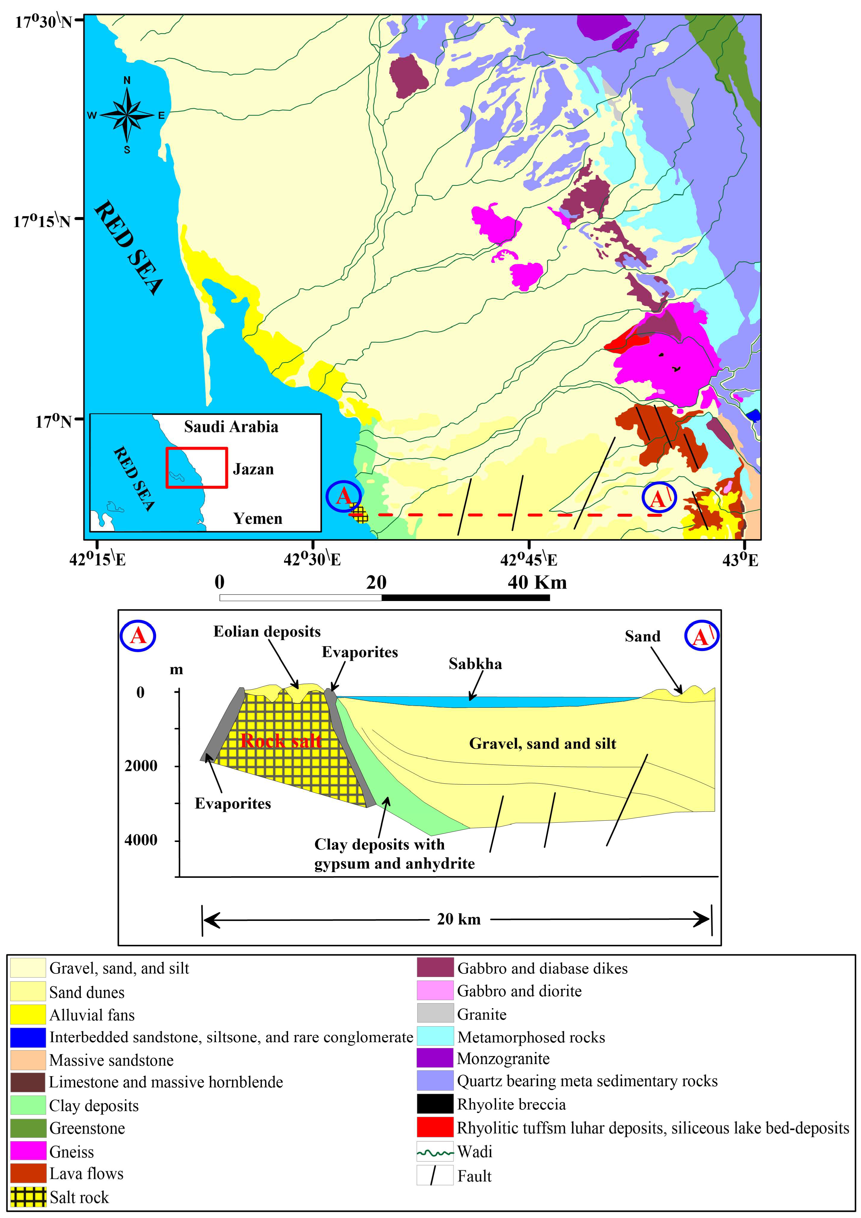
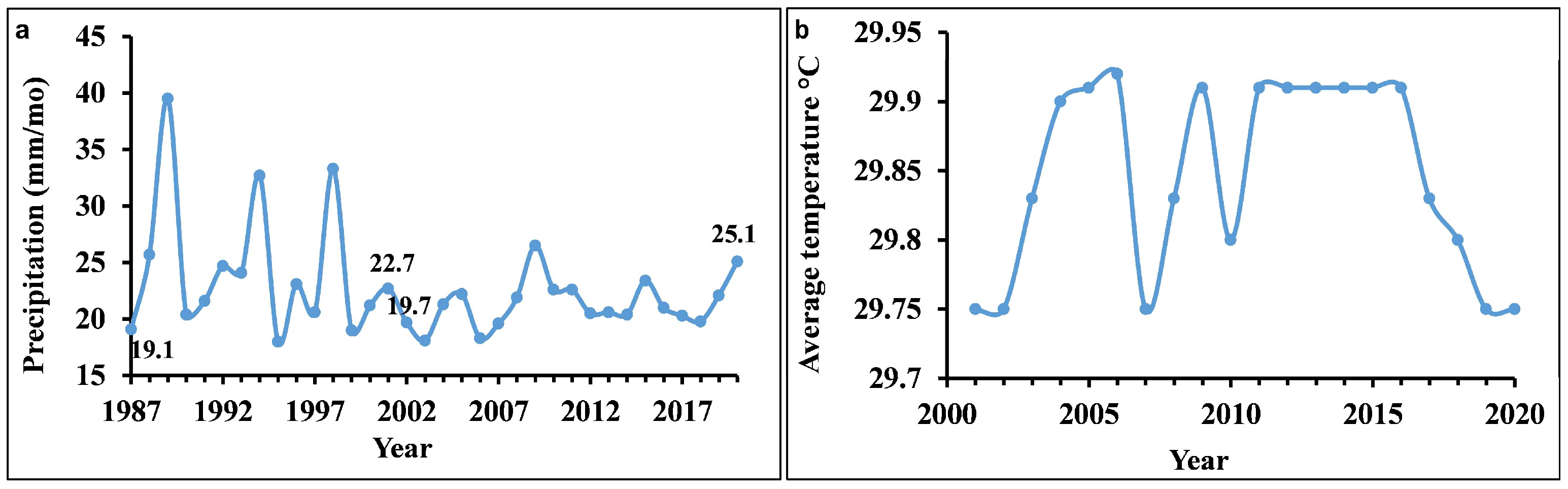
2.1. Study Area
2.2. Methodology
2.2.1. Multispectral Data and Image Processing
2.2.2. Derivation of NDVI, Albedo, and LST Indices
2.2.3. Tasseled Cap Transformation (TCT)
2.2.4. Linear Correlation Analysis and Desertification Degree Index (DDI)
2.2.5. Accuracy Assessment
2.2.6. Creation of the DDI Classes Change Matrix
3. Results
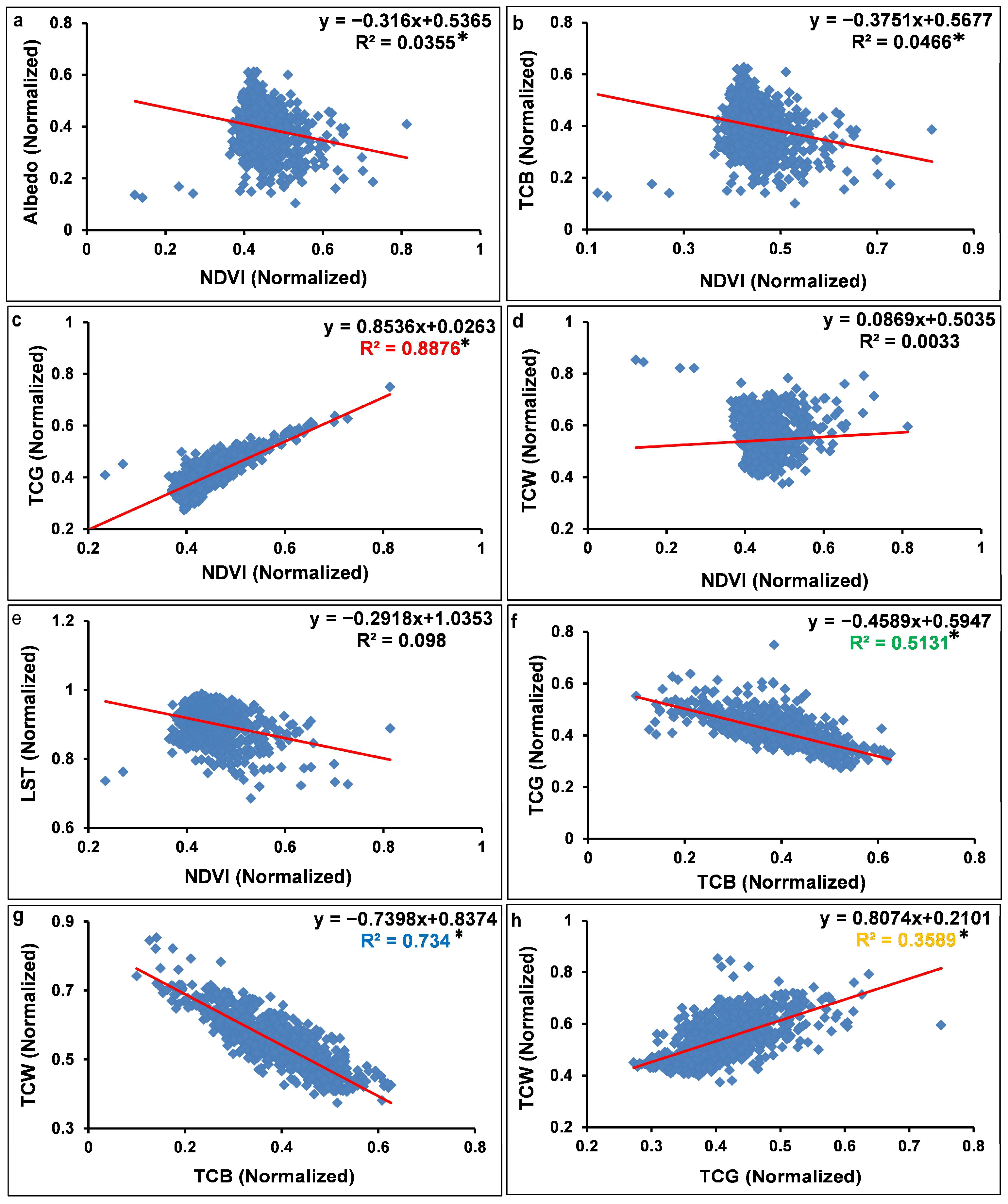
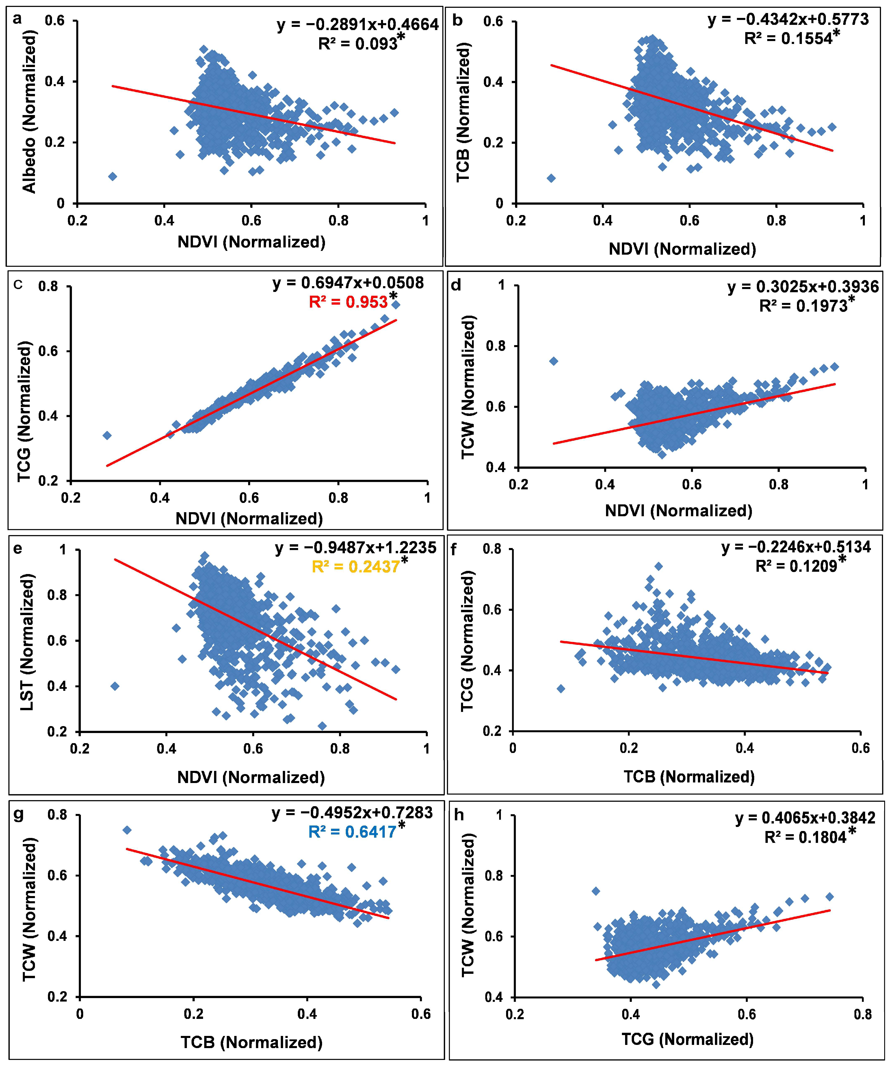
3.1. Derivation of NDVI, TCT Features, and LST
3.2. Linear Regression Analysis and the DDI Creation
3.3. Accuracy Assessment of DDI Classes
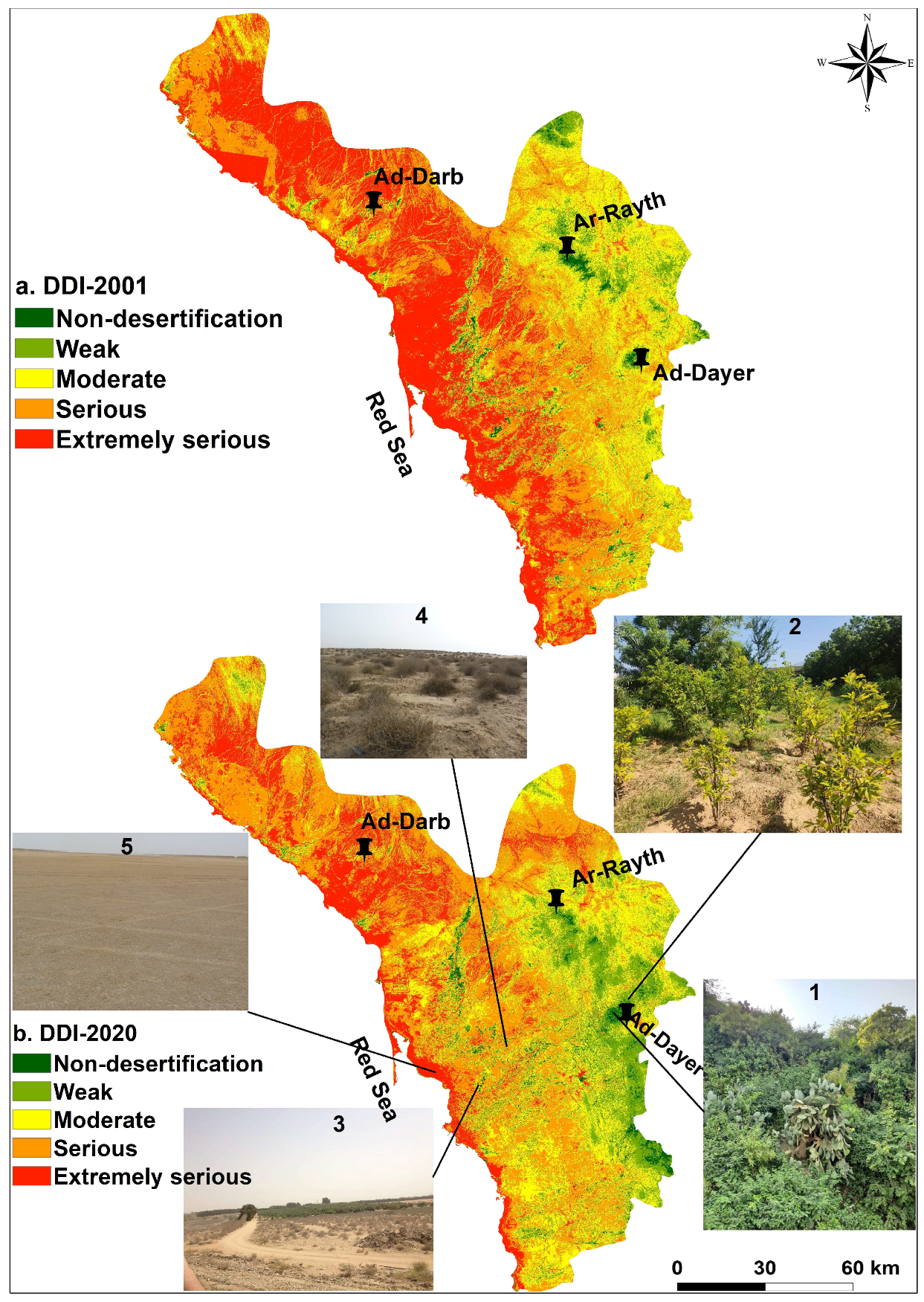
3.4. The Dynamic Changes of DDI and Its Characteristics
4. Discussion
4.1. The Spectral Indicators and the Desertification Evalution
4.2. Desertification in the Jazan Province
5. Conclusions
Author Contributions
Funding
Institutional Review Board Statement
Informed Consent Statement
Data Availability Statement
Conflicts of Interest
References
- Wang, T.; Xue, X.; Zhou, L.; Guo, J. Combating Aeolian Desertification in Northern China. Land Degrad. Dev. 2012, 26, 118–132. [Google Scholar] [CrossRef]
- United Nations Environment (UNE). World Atlas of Desertification: Second Edition. 1997. Available online: https://wedocs.unep.org/xmlui/handle/20.500.11822/30300 (accessed on 25 August 2023).
- Lichtenberg, E.; Ding, C. Assessing farmland protection policy in China. Land Use Policy 2008, 25, 59–68. [Google Scholar] [CrossRef]
- Cui, Y. Interpretation and Dynamic Analysis in Desertification—A Case Study of Kubuqi Desert. Appl. Mech. Mater. 2013, 295–298, 2102–2106. [Google Scholar] [CrossRef]
- Liu, S.; Wang, T. Aeolian desertification from the mid-1970s to 2005 in Otindag Sandy Land, Northern China. Environ. Geol. 2007, 51, 1057–1064. [Google Scholar] [CrossRef]
- Li, J.; Yang, X.; Jin, Y.; Yang, Z.; Huang, W.; Zhao, L.; Gao, T.; Yu, H.; Ma, H.; Qin, Z.; et al. Monitoring and analysis of grassland desertification dynamics using Landsat images in Ningxia, China. Remote Sens. Environ. 2013, 138, 19–26. [Google Scholar] [CrossRef]
- Ding, H.P.; Jianping, C.; Wang, G. A model for desertification evolution employing GIS with cellular automata. Comput. Model. Simul. 2009, 39, 324–328. [Google Scholar]
- Xue, Z.; Qin, Z.; Li, H.; Ding, G.; Meng, X. Evaluation of aeolian desertification from 1975 to 2010 and its causes in northwest Shanxi Province, China. Glob. Planet. Chang. 2013, 107, 102–108. [Google Scholar] [CrossRef]
- Alharbi, O.A.; Rangel-Buitrago, N. Landscape degradation in the Jazan coastal desert: Understanding the impact of human activities. Mar. Pollut. Bull. 2023, 190, 114874. [Google Scholar] [CrossRef]
- Mehravar, S.; Amani, M.; Moghimi, A.; Javan, F.D.; Samadzadegan, F.; Ghorbanian, A.; Stein, A.; Mohammadzadeh, A.; Mirmazloumi, S.M. Temperature-Vegetation-soil Moisture-Precipitation Drought Index (TVMPDI); 21-Year Drought Monitoring in Iran using Satellite Imagery within Google Earth Engine. Adv. Space Res. 2021, 68, 4573–4593. [Google Scholar] [CrossRef]
- Yang, G.; Chen, D.; He, X.L.; Long, A.H.; Yang, M.J.; Li, X.L. Land use change characteristics affected by water saving practices in Manas River Basin, China using Landsat satellite images. Int. J. Agric. Biol. Eng. 2017, 10, 6. [Google Scholar] [CrossRef]
- Meng, D.; Zhang, Z.; Yang, T.; Gong, H.; Zhao, W.; Li, X.; Gong, Z.; Wang, Y.; Hu, Z.; Sun, Y. Research on dynamic evolvement of desertification in Beijing and its neighboring areas by remote sensing. In Proceedings of the 2007 IEEE International Geoscience and Remote Sensing Symposium, Barcelona, Spain, 23–28 July 2007; p. 701. [Google Scholar] [CrossRef]
- Bai, Z.G.; Dent, D.L.; Olsson, L.; Schaepman, M.E. Proxy global assessment of land degradation. Soil Use Manag. 2008, 24, 223–234. [Google Scholar] [CrossRef]
- De Jong, R.; de Bruin, S.; de Wit, A.; Schaepman, M.E.; Dent, D.L. Analysis of monotonic greening and browning trends from global NDVI time-series. Remote Sens. Environ. 2011, 115, 692–702. [Google Scholar] [CrossRef]
- Fensholt, R.; Horion, S.; Tagesson, T.; Ehammer, A.; Grogan, K.; Tian, F.; Huber, S.; Verbesselt, J.; Prince, S.D.; Tucker, C.J.; et al. Assessment of Vegetation Trends in Drylands from Time Series of Earth Observation Data. In Remote Sensing Time Series: Revealing Land Surface Dynamics; Kuenzer, C., Dech, S., Wagner, W., Eds.; Remote Sensing and Digital Image Processing; Springer International Publishing: Cham, Switzerland, 2015; pp. 159–182. [Google Scholar] [CrossRef]
- Andela, N.; Liu, Y.Y.; van Dijk, A.I.J.M.; de Jeu, R.A.M.; McVicar, T.R. Global changes in dryland vegetation dynamics (1988–2008) assessed by satellite remote sensing: Comparing a new passive microwave vegetation density record with reflective greenness data. Biogeosciences 2013, 10, 6657–6676. [Google Scholar] [CrossRef]
- Feng, Y.; Wang, S.; Zhao, M.; Zhou, L. Monitoring of Land Desertification Changes in Urat Front Banner from 2010 to 2020 Based on Remote Sensing Data. Water 2022, 14, 1777. [Google Scholar] [CrossRef]
- Ma, Z.; Xie, Y.; Jiao, J.; Li, L.; Wang, X. The Construction and Application of an Aledo-NDVI Based Desertification Monitoring Model. Procedia Environ. Sci. 2011, 10, 2029–2035. [Google Scholar] [CrossRef]
- Lamqadem, A.A.; Saber, H.; Pradhan, B. Quantitative Assessment of Desertification in an Arid Oasis Using Remote Sensing Data and Spectral Index Techniques. Remote Sens. 2018, 10, 1862. [Google Scholar] [CrossRef]
- Kauth, R.; Thomas, G. The Tasselled Cap—A Graphic Description of the Spectral-Temporal Development of Agricultural Crops as Seen by LANDSAT. LARS Symp. 1976, 159, 41–51. Available online: https://docs.lib.purdue.edu/lars_symp/159 (accessed on 25 August 2023).
- Schoenert, M.; Weichelt, H.; Zillmann, E.; Jürgens, C. Derivation of Tasseled Cap Coefficients for RapidEye data. Proc. SPIE 2014, 9245, 153–163. [Google Scholar] [CrossRef]
- Jing-hu, P.; Xiaojuan, Q. Extracting desertification from landsat imagery using a feature space composed of vegetation index and albedo—A case study of Zhangye oasis and its adjacent areas. Sci. Surv. Mapp. 2010, 35, 193–195. Available online: https://www.semanticscholar.org/paper/Extracting-desertification-from-landsat-imagery-a-Jing-hu-Xiaojuan/7801b552c6e31abdd26554e51954d7c76ade7738 (accessed on 15 August 2023).
- Feoli, E.; Vuerich, L.G.; Zerihun, W. Evaluation of environmental degradation in northern Ethiopia using GIS to integrate vegetation, geomorphological, erosion and socio-economic factors. Agric. Ecosyst. Environ. 2002, 91, 313–325. [Google Scholar] [CrossRef]
- AL-Sheikh, A.B.Y. Environmental degradation and its impact on tourism in Jazan, KSA using Remote Sensing and GIS. Int. J. Environ. Sci. 2012, 3, 421–432. [Google Scholar] [CrossRef]
- El-Hamid, H.T.A.; Hafiz, M.A.; Wenlong, W.; Qiaomin, L. Detection of Environmental Degradation in Jazan Region on the Red Sea, KSA, Using Mathematical Treatments of Remote Sensing Data. Remote Sens. Earth Syst. Sci. 2019, 2, 183–196. [Google Scholar] [CrossRef]
- General Authority for Statistics. Population Characteristic Surveys. Available online: https://www.stats.gov.sa/en/5655 (accessed on 13 August 2023).
- Blank, H.R.; Johnson, P.; Gettings, M.E.; Simmons, G.C. Explanatory Notes to the Geologic Map of the Jizan Quadrangle; Deputy Ministry for Mineral Resources, Ministry of Petroleum and Mineral Resources: Jiddah, Saudi Arabia, 1985. [Google Scholar]
- El Sabrouti, M.A. Texture and mineralogy of the surface sediments of Sharm Obhur, west Red Sea coast of Saudi Arabia. Mar. Geol. 1983, 53, 103–116. [Google Scholar] [CrossRef]
- Basahel, A.N.; Bahafzalla, A.; Mansour, H.H.; Omara, S. Primary sedimentary structures and depositional environments of the Haddat Ash Sham sedimentary sequence, northeast of Jeddah, Saudi Arabia. Arab. Gulf J. Sci. Res. 1983, 1, 143–156. [Google Scholar]
- Batayneh, A.; Elawadi, E.; Mogren, S.; Ibrahim, E.; Qaisy, S. Groundwater quality of the shallow alluvial aquifer of Wadi Jazan (Southwest Saudi Arabia) and its suitability for domestic and irrigation purpose. Sci. Res. Essays 2012, 7, 352–364. [Google Scholar]
- Zabel, F.; Hank, T.B.; Mauser, W. Improving arable land heterogeneity information in available land cover products for land surface modelling using MERIS NDVI data. Hydrol. Earth Syst. Sci. 2010, 14, 2073–2084. [Google Scholar] [CrossRef]
- Lin, X.; Niu, J.; Berndtsson, R.; Yu, X.; Zhang, L.; Chen, X. NDVI Dynamics and Its Response to Climate Change and Reforestation in Northern China. Remote Sens. 2020, 12, 4138. [Google Scholar] [CrossRef]
- Liang, S.; Shuey, C.J.; Russ, A.L.; Fang, H.; Chen, M.; Walthall, C.L.; Daughtry, C.S.; Hunt, R. Narrowband to broadband conversions of land surface albedo: II. Validation. Remote Sens. Environ. 2003, 84, 25–41. [Google Scholar] [CrossRef]
- Chander, G.; Markham, B.L.; Helder, D.L. Summary of current radiometric calibration coefficients for Landsat MSS, TM, ETM+, and EO-1 ALI sensors. Remote Sens. Environ. 2009, 113, 893–903. [Google Scholar] [CrossRef]
- Silva, B.B.D.; Braga, A.C.; Braga, C.C.; de Oliveira, L.M.; Montenegro, S.M.; Barbosa, B., Jr. Procedures for calculation of the albedo with OLI-Landsat 8 images: Application to the Brazilian semi-arid. Rev. Bras. Eng. Agríc. Ambient. 2016, 20, 3–8. [Google Scholar] [CrossRef]
- Allen, R.G.; Tasumi, M.; Trezza, R.; Waters, R.; Bastiaanssen, W. “MET-479-Waters-et-al-SEBAL.pdf.” in Advance Training and Users Manual–Idaho Implementation. 2002. Available online: https://posmet.ufv.br (accessed on 13 August 2023).
- Baig, M.H.A.; Zhang, L.; Shuai, T.; Tong, Q. Derivation of a tasselled cap transformation based on Landsat 8 at-satellite reflectance. Remote Sens. Lett. 2014, 5, 423–431. [Google Scholar] [CrossRef]
- Huang, C.; Wylie, B.; Yang, L.; Homer, C.; Zylstra, G. Derivation of a tasselled cap transformation based on Landsat 7 at-satellite reflectance. Int. J. Remote Sens. 2002, 23, 1741–1748. [Google Scholar] [CrossRef]
- Pan, J.; Li, T. Extracting desertification from Landsat TM imagery based on spectral mixture analysis and Albedo-Vegetation feature space. Nat. Hazards 2013, 68, 915–927. [Google Scholar] [CrossRef]
- Becerril-Piña, R.; Delgado, C.D.; Mastachi, C.; Sosa, E.G. Integration of remote sensing techniques for monitoring desertification in Mexico. Hum. Ecol. Risk Assess. 2016, 22, 1323–1340. [Google Scholar] [CrossRef]
- Jenks, G.F. Generalization in Statistical Mapping. Ann. Assoc. Am. Geogr. 1963, 53, 15–26. [Google Scholar] [CrossRef]
- Prasad, S.V.S.; Savithri, D. Techniques in Image Classification; A Survey by Mr. 2015. Available online: https://www.semanticscholar.org/paper/Techniques-in-Image-Classification-%3B-A-Survey-By-Mr-Prasad-Savithri/32acc00da16974a93c66834d5016d7ecb2150482 (accessed on 13 December 2023).
- Lu, D.; Mausel, P.; Brondízio, E.; Moran, E. Change detection techniques. Int. J. Remote Sens. 2004, 25, 2365–2401. [Google Scholar] [CrossRef]
- Liu, D.; Li, B.; Liu, X.; Warrington, D.N. Monitoring land use change at a small watershed scale on the Loess Plateau, China: Applications of landscape metrics, remote sensing and GIS. Environ. Earth Sci. 2011, 64, 2229–2239. [Google Scholar] [CrossRef]
- Tian, F.; Qiu, G.; Yang, Y.; Xiong, Y.J.; Wang, P. Studies on the Relationships Between Land Surface Temperature and Environmental Factors in an Inland River Catchment Based on Geographically Weighted Regression and MODIS Data. IEEE J. Sel. Top. Appl. Earth Obs. Remote Sens. 2012, 5, 687–698. [Google Scholar] [CrossRef]
- Rahman, M.M.; Szabó, G. Impact of Land Use and Land Cover Changes on Urban Ecosystem Service Value in Dhaka, Bangladesh. Land 2021, 10, 793. [Google Scholar] [CrossRef]
- Goetz, S.J. Multi-sensor analysis of NDVI, surface temperature and biophysical variables at a mixed grassland site. Int. J. Remote Sens. 1997, 18, 71–94. [Google Scholar] [CrossRef]
- Kustas, W.P.; Moran, M.S.; Humes, K.S.; Stannard, D.I.; Pinter, P.J.; Hipps, L.E.; Swiatek, E.; Goodrich, D.C. Surface energy balance estimates at local and regional scales using optical remote sensing from an aircraft platform and atmospheric data collected over semiarid rangelands. Water Resour. Res. 1994, 30, 1241–1259. [Google Scholar] [CrossRef]
- Duan, H.; Wang, T.; Xue, X.; Yan, C. Dynamic monitoring of aeolian desertification based on multiple indicators in Horqin Sandy Land, China. Sci. Total Environ. 2019, 650, 2374–2388. [Google Scholar] [CrossRef] [PubMed]
- Crist, E.P.; Laurin, R.; Cicone, R.C. Vegetation and Soils Information Contained in Transformed Thematic Mapper Data. Available online: http://www.ciesin.org/docs/005-419/005-419.html (accessed on 21 April 2024).


| Index | Equation | Abbreviations | |
|---|---|---|---|
| Overall accuracy | (9) | r the number of rows and columns in the confusion matrix n the total number of pixels in the confusion matrix xii major diagonal element for class i xi+ count of pixels in row i x+i count of pixels in column i | |
| User accuracy | (10) | ||
| Producer accuracy | (11) | ||
| Kappa coefficient | (12) | ||
| Pearson Correlation Coefficient (r) | ||
|---|---|---|
| 2001 | NDVI–albedo | −0.18 * |
| NDVI–TCB | −0.21 * | |
| NDVI–TCG | 0.79 * | |
| NDVI–TCW | 0.05 | |
| NDVI–LST | −0.31 | |
| TCB–TCG | −0.71 * | |
| TCB–TCW | −0.70 * | |
| TCG–TCW | 0.59 * | |
| 2020 | NDVI–albedo | −0.30 * |
| NDVI–TCB | −0.39 * | |
| NDVI–TCG | 0.97 * | |
| NDVI–TCW | 0.44 * | |
| NDVI–LST | −0.49 * | |
| TCB–TCG | −0.34 * | |
| TCB–TCW | −0.80 * | |
| TCG–TCW | 0.42 * |
| DDI Classes | 2001 | 2020 | ||
|---|---|---|---|---|
| Area (km2) | % | Area (km2) | % | |
| Non-desertification | 227 | 1.51 | 356.70 | 2.37 |
| Weak | 1122.17 | 7.47 | 2288.69 | 15.23 |
| Moderate | 3420.03 | 22.76 | 3823.20 | 25.45 |
| Serious | 5468.43 | 36.40 | 6101.34 | 40.61 |
| Extremely serious | 4787.30 | 31.86 | 2455 | 16.34 |
| DDI Classes | 2001 | 2020 | ||
|---|---|---|---|---|
| User’s | Producer’s | User’s | Producer’s | |
| Non-desertification | 100 | 95.4 | 100 | 95.7 |
| Weak | 95.9 | 100 | 92.3 | 92.3 |
| Moderate | 96.8 | 96.8 | 95.4 | 94 |
| Serious | 97.3 | 92.5 | 93.8 | 98.7 |
| Extremely serious | 97.6 | 100 | 100 | 95.5 |
| Kappa | 96.4 | 95.8 | ||
| Overall | 97.2 | 94.3 | ||
| DDI Classes | 2020 | ||||||
|---|---|---|---|---|---|---|---|
| Non- Desertification | Weak | Moderate | Serious | Extremely Serious | Total Reduced | ||
| 2001 | Non- desertification | 54.1 | 93.8 | 42.6 | 32.4 | 4 | 226.9 |
| Weak | 97.3 | 489.6 | 366.1 | 146.1 | 22.6 | 1121.6 | |
| Moderate | 106 | 1062.5 | 1284.5 | 843.8 | 121.5 | 3418.4 | |
| Serious | 44.3 | 504.1 | 1518.5 | 2819.5 | 580.1 | 5466.4 | |
| Extremely serious | 23.5 | 144.7 | 620.5 | 2268.1 | 1726.6 | 4783.4 | |
| Total increased | 325.1 | 2294.8 | 3832.1 | 6109.9 | 2454.8 | 15,016.7 | |
| Severe Degradation | Degradation | No Change | Restoration | Obvious Restoration | |
|---|---|---|---|---|---|
| Area (km2) | 369.49 | 1968.11 | 6374.34 | 4737.09 | 1567.69 |
| % | 2.46 | 13.11 | 42.45 | 31.55 | 10.44 |
Disclaimer/Publisher’s Note: The statements, opinions and data contained in all publications are solely those of the individual author(s) and contributor(s) and not of MDPI and/or the editor(s). MDPI and/or the editor(s) disclaim responsibility for any injury to people or property resulting from any ideas, methods, instructions or products referred to in the content. |
© 2024 by the authors. Licensee MDPI, Basel, Switzerland. This article is an open access article distributed under the terms and conditions of the Creative Commons Attribution (CC BY) license (https://creativecommons.org/licenses/by/4.0/).
Share and Cite
Hasan, S.S.; Alharbi, O.A.; Alqurashi, A.F.; Fahil, A.S. Assessment of Desertification Dynamics in Arid Coastal Areas by Integrating Remote Sensing Data and Statistical Techniques. Sustainability 2024, 16, 4527. https://doi.org/10.3390/su16114527
Hasan SS, Alharbi OA, Alqurashi AF, Fahil AS. Assessment of Desertification Dynamics in Arid Coastal Areas by Integrating Remote Sensing Data and Statistical Techniques. Sustainability. 2024; 16(11):4527. https://doi.org/10.3390/su16114527
Chicago/Turabian StyleHasan, Samia S., Omar A. Alharbi, Abdullah F. Alqurashi, and Amr S. Fahil. 2024. "Assessment of Desertification Dynamics in Arid Coastal Areas by Integrating Remote Sensing Data and Statistical Techniques" Sustainability 16, no. 11: 4527. https://doi.org/10.3390/su16114527
APA StyleHasan, S. S., Alharbi, O. A., Alqurashi, A. F., & Fahil, A. S. (2024). Assessment of Desertification Dynamics in Arid Coastal Areas by Integrating Remote Sensing Data and Statistical Techniques. Sustainability, 16(11), 4527. https://doi.org/10.3390/su16114527