1. Introduction
As urbanization accelerates worldwide, fostering inclusive and environmentally friendly cities becomes paramount. Pedestrian access plays a pivotal role in enhancing mobility, safety, and social connectivity. Additionally, promoting non-motorized mobility directly contributes to reducing carbon emissions and mitigating the ecological impact of urban expansion.
In this context, developing a method for the optimal selection of pedestrian bridge locations, considering technical, economic, social, and environmental criteria, is crucial, especially when dealing with limited and potentially unclear or uncertain information. An MCDM approach can significantly improve sustainable urban planning on a global scale.
In the dynamic field of urban planning, the strategic identification of locations for pedestrian access stands as a critical challenge for constructing urban environments that are not only safe and efficient but also sustainable [
1,
2]. Despite the acknowledged importance of this endeavor, there remains a notable research gap in optimizing the selection of these locations, particularly in the integration of mathematical modeling methodologies and comprehensive multidisciplinary criteria [
3,
4,
5].
This research is driven by the recognition that the existing body of work falls short in addressing the nuanced complexities of urban landscapes. While prior studies have touched upon the general importance of pedestrian access, there is a distinct lack of focus on refining the decision-making processes involved in site selection. This gap becomes particularly evident in the dearth of studies exploring the application of advanced mathematical models and facilities engineering in the realm of pedestrian mobility.
Furthermore, the existing literature often overlooks the specific challenges faced by urban environments in middle-income countries, such as Chile. The accelerated urbanization and population concentration in these regions necessitate tailor-made engineering solutions, making it imperative to bridge this gap in current research [
6,
7,
8].
This study’s significance extends beyond theoretical frameworks, manifesting tangible benefits for urban communities. By delving into the optimal placement of pedestrian access, this research directly contributes to reducing environmental impact, enhancing non-motorized mobility, and mitigating vehicular congestion. This goes beyond the standard considerations found in the current literature, thereby filling a crucial void in the understanding of sustainable urban planning.
In the context of cities like Coquimbo, Chile, where growth and development are constant, the need for a comprehensive study becomes even more apparent. This research aims to not only address the immediate challenges faced by such cities but also contribute to a broader understanding of sustainable urban planning.
This study is a pioneering effort to unravel the intricacies of efficient site selection for pedestrian bridges. By employing innovative mathematical models within the context of urban engineering and facilities management, it seeks to fill the existing void in research that neglects the technical nuances of decision-making processes.
This study addresses the gaps in the current understanding of site selection criteria by applying multi-criteria decision-making methods rooted in mathematical models and facilities engineering. This includes, but is not limited to, technical aspects, economic considerations, social dimensions, and environmental impacts [
9,
10].
In essence, this research not only identifies the research gap in the existing literature but also endeavors to bridge that gap by offering a comprehensive and practical approach. By considering complex variables and optimizing the selection of locations for pedestrian access efficiently and effectively, this study promises to reshape current perceptions, offering invaluable insights for urban planners and facility managers alike. This study’s importance lies in addressing immediate challenges and pioneering a paradigm shift towards more sustainable, efficient, and inclusive urban environments.
While acknowledging the importance of pedestrian access for urban mobility and sustainability, this research points out a lack of methods for strategically selecting pedestrian access points.
The problem lies in the absence of approaches that integrate multidisciplinary criteria and mathematical models for decision making concerning pedestrian bridge locations.
This study aims to develop a method for optimally selecting locations for urban pedestrian bridges, utilizing MCDM techniques.
This involves the following:
Developing a model that considers technical, economic, social, and environmental criteria;
Employing mathematical models to optimize the selection of locations for footbridges;
Applying the model to a real situation as a study case.
The remaining sections of this paper are organized as follows:
Section 2 presents the materials and methods, which includes a literature review regarding MCDM applications in urban planning. The importance of our research is also discussed in this section.
Section 3 describes the results of the research case study, criteria, and alternatives, in addition to the final results of the criteria assessment, evaluation of its alternatives, and the robustness test for the introduced methodology. A discussion is provided in
Section 4 regarding the results and implemented methodology. The conclusion of our research paper is presented in
Section 5.
2. Literature Review and Methods
2.1. The Importance
Urban planning plays a pivotal role in shaping the functionality and livability of cities. Within this broad spectrum, the optimization of pedestrian paths emerges as a critical facet, directly influencing the quality of urban life, safety, and overall sustainable development. It is important to review the impact of urban planning definitions from different perspectives to assess their influence on decisions in order to generate a significant contribution to citizenship.
Optimizing pedestrian paths is integral to promoting efficient and sustainable urban mobility. Well-designed and accessible pathways encourage residents and visitors to choose walking as a viable mode of transportation. This not only reduces reliance on motorized vehicles but also contributes to mitigating traffic congestion and lowering carbon emissions [
11].
Additionally, pedestrian-friendly environments foster community connectivity by creating spaces that encourage social interactions. Well-designed paths facilitate face-to-face encounters, promoting a sense of community and enhancing the overall social fabric of urban areas. This, in turn, contributes to a vibrant and cohesive urban society [
12].
Prioritizing pedestrian paths in urban planning directly addresses safety concerns and promotes accessibility for all residents. Properly designed walkways with appropriate signage, crossings, and lighting contribute to a safer urban environment. Moreover, accessible pathways ensure that individuals with diverse mobility needs can navigate the city independently, promoting inclusivity [
13].
The promotion of pedestrian paths aligns with public health objectives by encouraging physical activity. Accessible and aesthetically pleasing walkways motivate individuals to incorporate walking into their daily routines, combating sedentary lifestyles and associated health issues. This, in turn, contributes to a healthier and more resilient urban population [
14].
Optimizing pedestrian paths is a key element of sustainable urban development. By prioritizing walking as a mode of transportation, cities can reduce their ecological footprint, conserve energy, and create environmentally conscious and economically viable environments [
15].
Pedestrian-friendly urban planning has economic advantages, attracting businesses and promoting local commerce. Vibrant, walkable areas often become hubs of economic activity, as people are more inclined to explore and spend time in areas with accessible and appealing pedestrian infrastructure [
16].
In summary, optimizing pedestrian paths in urban planning is not merely about creating walkways; it is about fostering a holistic and sustainable urban environment. By prioritizing pedestrian needs, cities can create functional spaces that promote health, community, and economic vitality. This underlines the fundamental role of optimizing pedestrian routes in shaping the future of urban landscapes. However, it is also noted that there is still a lack of work that integrates expert-assessed perspectives, including their own perception biases, into a single model.
2.2. MCDM in Urban Planning
MCDM plays a crucial role in addressing complex urban planning issues, particularly those related to pedestrian paths. In the context of urban planning, MCDM provides a systematic approach for decision makers to evaluate and prioritize various criteria, accommodating the multifaceted nature of urban environments. Pedestrian paths are integral components of urban infrastructure, influencing accessibility, safety, and overall livability. The application of MCDM methodologies facilitates the optimization of pedestrian path networks by considering diverse factors simultaneously.
One significant aspect of employing MCDM in urban planning for pedestrian paths is the consideration of multiple criteria, such as safety, accessibility, aesthetics, and environmental impact. For example, a decision-making process may involve evaluating the proximity of paths to key amenities, ensuring universal accessibility, and minimizing environmental disruptions. The Analytical Hierarchy Process (AHP) and Technique for Order of Preference by Similarity to Ideal Solution (TOPSIS) are among the widely used MCDM methods in urban planning scenarios, providing structured frameworks for assessing and comparing alternatives.
Research studies highlight the effectiveness of MCDM in addressing pedestrian-related challenges in urban areas. A study by [
17] applied the AHP method to assess pedestrian infrastructure in urban environments, emphasizing the importance of considering various criteria for creating walkable and inclusive pathways [
17]. Another study by [
18] utilized TOPSIS to prioritize pedestrian-friendly designs based on criteria such as safety, aesthetics, and connectivity, demonstrating the applicability of MCDM in enhancing urban pedestrian experiences [
18].
Huang et al. [
19] conducted a study on the integration of the Analytical Hierarchy Process (AHP) and Geographic Information System (GIS) for the analysis of pedestrian-friendly environments in urban residential communities. Their research explores the synergies between AHP and GIS to assess and prioritize various factors influencing pedestrian pathways, contributing valuable insights into developing urban spaces that enhance walkability and resident satisfaction.
In industries like manufacturing, MCDM methods allow for the determination of the best location for a plant or service facility, with TOPSIS, SAW, GRA, and MOORA among them [
20].
Therefore, data envelope analysis (DEA) has been integrated with MCDM as an effective approach to decision making [
21].
Hassanshahi et al. [
22] delved into the application of MCDM and GIS to identify optimal locations for pedestrian overpasses in urban areas. Their study utilizes a combination of MCDA and GIS techniques to assess various factors influencing pedestrian mobility and safety, offering a systematic approach to decision making in urban planning. By selecting optimal locations for pedestrian overpasses, their research contributes to the enhancement of urban pedestrian environments and addresses safety concerns.
Alemdar et al. [
23], in a case study in Erzurum, Turkey, conducted a study titled “A GIS and microsimulation-based MCDA approach for evaluation of pedestrian crossings,” focusing on the critical aspects of urban traffic safety. Their research emphasizes the significance of meticulous planning for pedestrian crossings, which often become sites of collisions between vehicles and pedestrians, leading to traffic violations and safety concerns. Employing a corridor-based analysis, the authors identified twenty-four criteria affecting pedestrian crossing locations and traffic flow. Using Geographical Information Systems (GISs), they applied the Analytic Hierarchy Process (AHP) and VlseKriterijuska Optimizacija I Komoromisno Resenje (VIKOR) from Multi-Criteria Decision Analysis (MCDA) to determine the most suitable pedestrian crossing scenario. PTV VISSIM was employed to assess the impact of these crossings on traffic.
In conclusion, applying multiple criteria decision-making models in urban planning for pedestrian paths provides a comprehensive approach to addressing the multifaceted challenges associated with urban mobility. By considering various criteria simultaneously, MCDM methodologies contribute to the creation of safe, accessible, and aesthetically pleasing pedestrian pathways, ultimately enhancing the overall urban living experience.
2.3. Applications and Case Studies
Several studies have applied MCDM to pedestrian path planning, showcasing its efficacy in real-world scenarios. These applications range from optimizing path layouts to improving safety measures and ensuring better accessibility. Case studies highlight successful outcomes, offering insights into the practical benefits of MCDM in urban environments. The latest related studies are shown in
Table 1 to help readers understand better.
2.4. Methodology
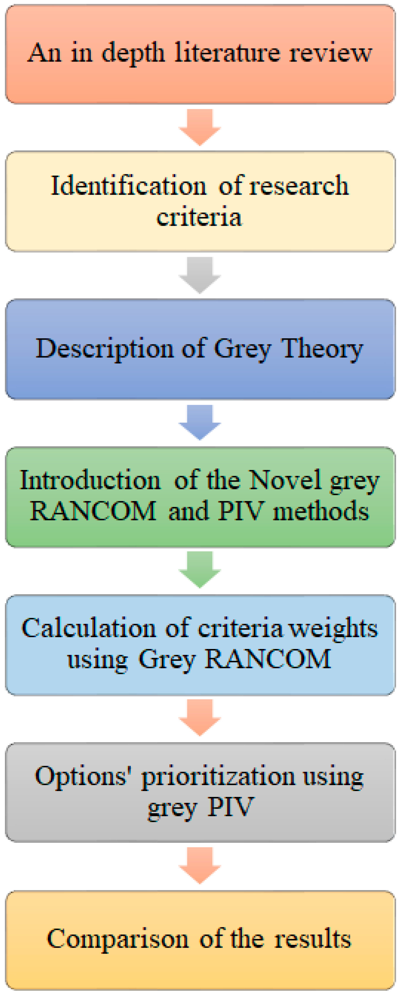
This section introduces a novel hybrid MCDM model that utilizes grey theory. First, grey RANCOM is introduced and implemented to obtain criteria and sub-criteria weights. Then, grey PIV is used to prioritize the research alternatives for the first time.
Figure 1 shows the research methodology procedure.
2.4.1. Grey Theory Description
When there is uncertainty or lack of consensus about the measure’s importance, decision makers may use linguistic terms or other techniques, such as fuzzy logic grey theory, etc., to describe the significance of research standards [
32]
This research benefits from a full grey methodology, which was developed based on grey numbers.
A grey number is defined as a number whose exact value is unknown but has a known range. Grey numbers are usually represented as a closed interval or as a set of numbers [
32].
A grey number is defined as , where the whitening degree is defined as .
For two grey numbers, ⊗
and ⊗
, the mathematic operations can be defined as
The length of the grey interval is defined as .
The possibility degree of two grey numbers, ⊗
and ⊗
, is expressed as
For the position relation between two grey values,
if P{ ≥ } < 0.5, then < , which means that is smaller than ;
if P{ ≥} = 0.5, then = , which implies that is equal to ;
if P{ ≥ } > 0.5, then > , which means that is more significant than .
2.4.2. Grey RANCOM
The RANking COMparison (RANCOM) method is a newly introduced technique [
33] that uses the experts’ subjective knowledge and opinions about the criteria. This method benefits from a pairwise comparison process to evaluate the importance of criteria weights. The steps of grey RANCOM are as follows:
- Step 1.
Prioritize the criteria according to defined grey intervals.
In the first step, the research criteria are evaluated according to the designated grey numbers shown in
Table 2.
- Step 2.
Set up the matrix of ranking comparison.
In order to create the matrix of ranking comparison, the whitening degree of each interval is calculated, and then, the pairwise comparison is established according to the whitening degrees of each criterion.
- Step 3.
Calculate the summed criteria weights.
In this step, the summed criteria weights are calculated by adding each row’s values separately from the ranking comparison matrix.
- Step 4.
Obtain the final criteria weights.
The final weights of each criterion are calculated by utilizing the following formula:
2.4.3. Grey PIV
Muffazal and Muzakkir [
34] introduced the proximity-indexed value method (PIV) to decrease the effect of the rank reversal phenomenon. Goswami et al. [
35] utilized PIV to select India’s green renewable energy source. Khan et al. [
36] introduced a novel PIV method to prioritize the E-learning websites. The steps of grey PIV are as follows:
- Step 1.
Set up the Primary Decision Matrix (PDM)
The primary decision matrix is created according to i alternatives and j criteria using grey intervals, which are based on defined lower and upper bounds .
- Step 2.
Normalize the PDM
In order to normalize the primary decision matrix, the ideal (
AI) and anti-ideal (
AAI) solutions of each column need to be calculated, as follows:
where, in these equations,
shows a group of benefit criteria while
represents a group of cost criteria.
- Step 3.
Calculate the weighted normalized PDM
The weighted normalized values are obtained by Equation (8), as follows:
- Step 4.
Evaluation of Weighted Proximity Index (WPI)
In this step, the WPI values are obtained according to the following equations and grey number rules:
- Step 5.
Determine the overall proximity value
The overall proximity value (
) is equal to the summation of the whitening degree of weighted proximity indexes.
- Step 6.
Rank the alternatives
The best alternative is the one that has the lowest .
3. Results
3.1. Conceptual Model and a Case Study from Chile
3.1.1. An Introduction to the Case Study (Coquimbo Region, Chile)
The conurbation of La Serena–Coquimbo, situated in the northern zone of Chile, holds a significant position within a region with a population of 757,586, as reported in the 2017 Census. Among the cities in this region, the coastal city of Coquimbo stands out with the largest population, boasting 227,730 inhabitants, with 94.2% of them residing in the urban area. The region’s climate, described as generally pleasant, has attracted a steady influx of residents, even prompting migration from other cities to settle in Coquimbo [
37].
In Chile’s political administration context, the term “Commune” is used to denote cities with autonomous organizations facilitated by a municipality and led by a democratically elected leader. This administrative structure encompasses crucial aspects such as project definition, including initiatives like the construction of facilities. The active involvement of the municipality, under democratic principles, underscores the region’s commitment to local governance and community-driven development. Understanding the intricate relationship between political administration, demographic patterns, and environmental factors in the La Serena–Coquimbo conurbation is essential for effective urban planning and decision-making processes.
3.1.2. Conceptual Model of Criteria Selection and Adaption, Aiming to Enhance the Flexibility and Effectiveness of Decision-Making Processes
Based on the literature review, six criteria and twenty-one sub-criteria are defined to evaluate decision makers about the location of footbridges for sustainable transportation in a city.
Connectivity: It is reasonable to think that adding new walkways improves pedestrian path communication, avoiding waiting time while passing vehicles in the crossing area [
38]; this directly benefits the travel time of a pedestrian seeking to access a defined point or else wishing to maximize the number of destinations to reach in a similar comparison time [
39]. Therefore, connectivity and integration positively result in benefits pedestrians [
40].
Integration: expert perception of the frame of reference, associated with measuring the closeness of the points of interest to each other; thus, understanding this criterion is desired in order to maximize integration between them.
Connectivity: considers the perception of the number of streets above an examined point; this can be associated with the distance people travel from one point to another, passing through several intermediate streets.
Crossing time: the relative time a pedestrian takes to move from one sidewalk to another in front of it.
Waiting time: the relative time a pedestrian is ready to cross from one sidewalk to another in front of him, waiting for suitable conditions.
Image: It can be essential to establish characteristics of an attractive and desirable city for a citizen to live in, beyond operational aspects. A walkway provides spaces to obtain partial views of the city, and a pedestrian can tactically decide his route by considering the visibility of the construction to visualize it from distances relatively far from the point of connection [
41].
View: perspective or panorama from a walkway, either elevated above the ground or at a strategic point, offering a panoramic view.
Visibility: the ability to be seen from multiple points in a city, standing out as a prominent visual element that can be observed from different urban locations, providing a recognizable landmark in the urban landscape.
Tourist attraction: the ability to offer unique panoramic views or access to emblematic sites, attracting visitors due to their visual and experience-based appeal.
Safety: Pedestrian safety is enhanced by minimizing vehicle confrontation [
42]. Therefore, a condition can be established that seeks to evaluate the reduction in this contact, considering the speed of traffic [
43], the flow of vehicular traffic, the direction of traffic flow, and road safety itself, in addition to the length of the crossing that the pedestrian must face and the number of traffic lanes. The above makes it possible to establish that the higher the driving speed and traffic flow, the more critical it will be to consider a crosswalk [
38,
41,
42].
Driving speed: the speed at which a vehicle travels over a given distance in a specified period on a road or highway.
Traffic flow: the number of vehicles passing a specific point on a road in a given time.
Length of the pedestrian crossing: horizontal distance between demarcation lines that indicate safe crossing for pedestrians at an intersection or designated area, facilitating their passage from one side of the street to the other.
Number of traffic lanes: number of lanes available for vehicles on a road or street, determining the capacity of vehicular flow. If pedestrian activity is encouraged, reducing the number of lanes is desirable.
Vehicle movement direction: the direction or the permitted and regulated flow vehicles must follow on the road, determined by road regulations and specific signage.
Road safety: measures and conditions guaranteeing the protection and prevention of traffic accidents and promoting the physical integrity of drivers, pedestrians, and road users.
Health: Walking as a means of transportation contributes positively to people’s health. However, it is essential to verify whether a criterion associated with walking as a physical activity is important when deciding on installing walkways; in addition, direct contact with traditional vehicles and their emission of toxic gases could harm pedestrians’ health [
41].
Sports activities: physical practices or exercises involving specific skills performed for recreational, competitive, or health purposes. From a pedestrian perspective, including sports can encourage an active and safe lifestyle, integrating walking, jogging, or strolling as an essential daily routine.
Contribution to the reduction in toxic gases: actions that reduce the emission of harmful substances into the environment, such as CO2. Regarding pedestrians, this involves promoting non-motorized means of transportation, such as walking or using bicycles, thus reducing dependence on motor vehicles and polluting emissions.
Cost: Investment in facilities such as walkways is also generally an essential factor when deciding to build. Considering the costs associated with their life cycle may be relevant to the decision to move forward with the investment, valuing at least the costs of design, construction, and maintenance [
42,
44].
Cost of design: a set of expenses associated with a structure or project’s planning, development, and construction projection. In the case of pedestrian walkways, this cost involves the financial resources allocated to architectural design, construction materials, and labor, also considering aspects of accessibility and safety for pedestrians.
Cost of construction: economic expense associated with creating a structure or project. In the context of pedestrian walkways, this cost involves materials and labor to ensure safety and accessibility, influencing the viability and extension of these infrastructures.
Cost of maintenance: the expenses associated with the maintenance and repair of structures or infrastructure. In the context of pedestrian walkways, it involves the financial and labor resources required to ensure their safety, functionality, and durability over time.
Environment and Comfort: A sense of well-being is part of the pedestrian’s pleasurable experience of urban transit [
45]. Noise factors, comfort, and the possibility of having adequate handicapped access contribute to the possibility of deciding on a crosswalk access that maximizes this experience [
42].
Noise and environmental impact: Noise refers to unwanted sounds that can cause discomfort or affect health, while ecological impact refers to the negative consequences that human actions have on the environment. Pedestrian walkways can reduce noise by separating pedestrians from direct vehicular traffic, thus reducing noise impact and improving the environmental quality of urban areas.
Comfort: implies a sense of comfort and well-being. In the context of pedestrian walkways, it relates to safety, ergonomic design, and protection from weather conditions to ensure a pleasant and safe walking experience for pedestrians.
Access for the disabled implies providing facilities and adaptations in infrastructure to ensure their inclusion. In the context of pedestrian walkways, this means the installation of ramps, handrails, and other elements that allow for safe and accessible transit for people with physical disabilities or reduced mobility.
Throughout this paper, we have articulated the rationales underpinning these elements, laying the foundation for a robust and well-considered approach to our study.
Table 3 presents a hierarchical arrangement of the conceptual model’s criteria and sub-criteria, along with their corresponding references, providing a comprehensive reference point for the nuanced components of our analytical framework.
3.1.3. Possible Locations
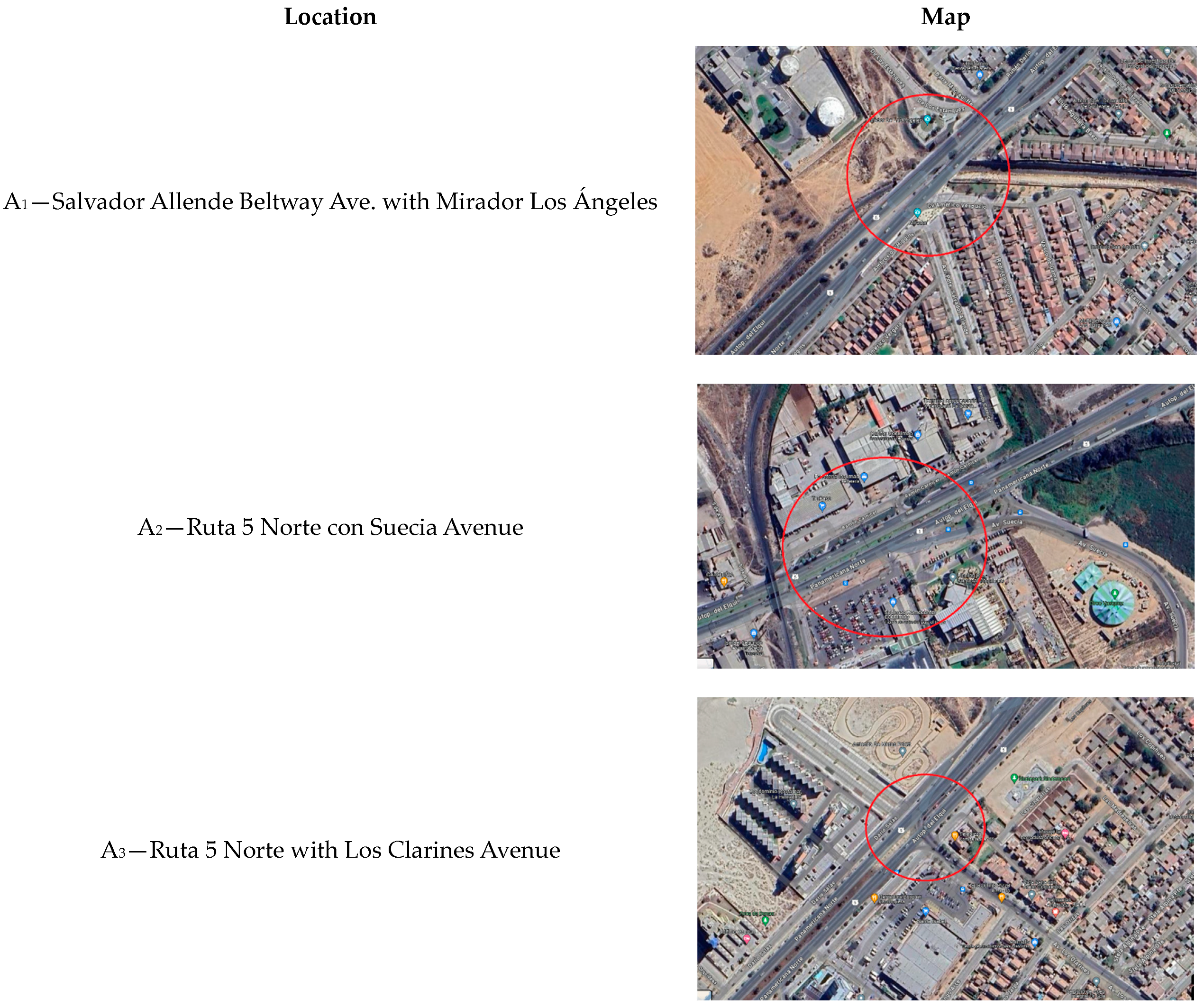
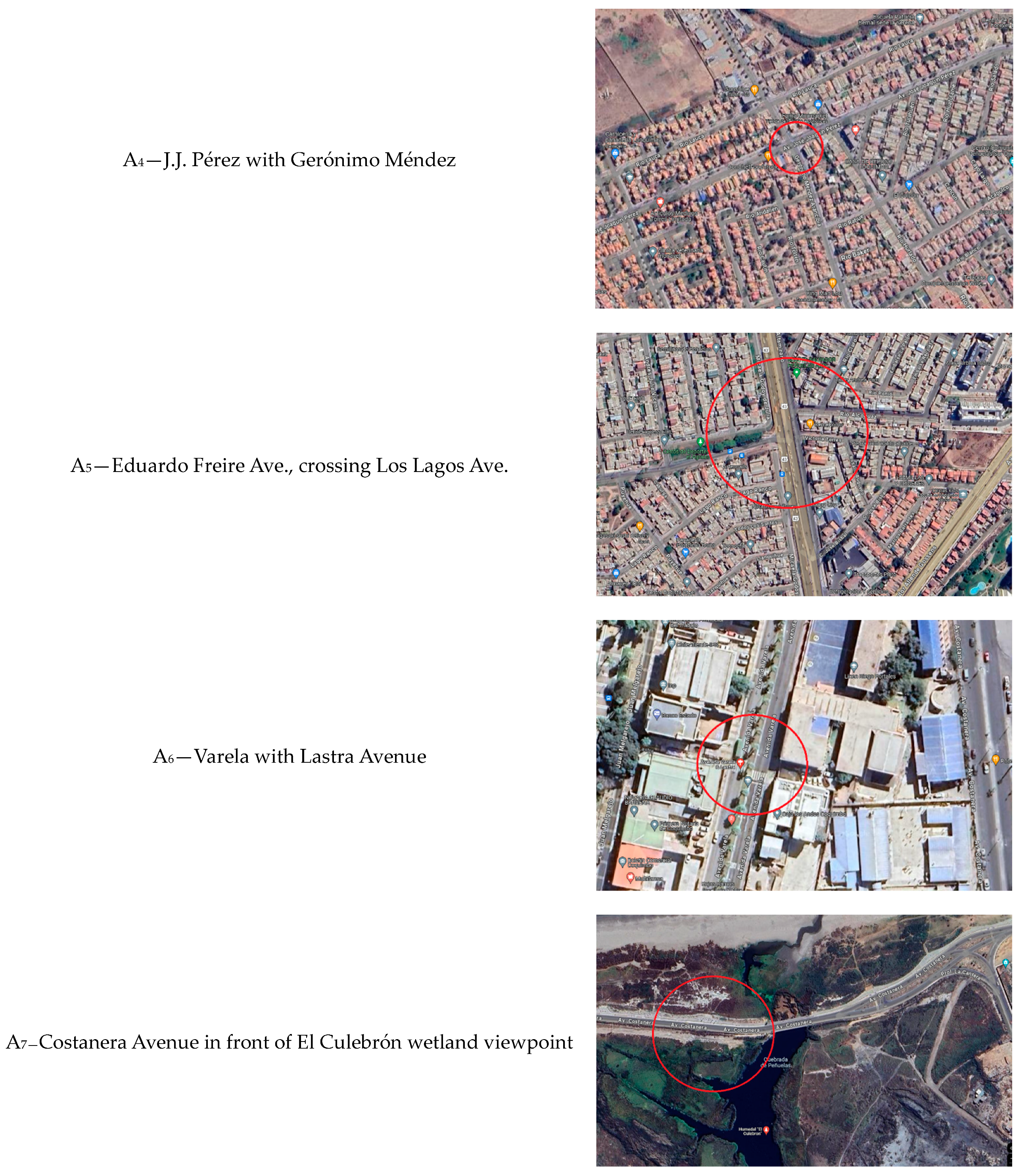
In consultation with experts responsible for coordinating and administering municipal traffic, specifically within the Municipality of Coquimbo, a comprehensive assessment was conducted to identify potential key locations suitable for the installation of pedestrian bridges. Leveraging the valuable insights of these experts, the aim was to pinpoint areas with high pedestrian activity, traffic flow, and strategic urban significance. This process involved an in-depth analysis of existing traffic patterns, urban development plans, and considerations for enhancing pedestrian safety and connectivity.
In the subsequent sections, we present a curated list of potential locations for pedestrian bridges, each supported by a detailed evaluation of the surrounding urban context. This evaluation encompasses factors such as foot traffic density, proximity to key amenities, existing transportation infrastructure, and urban development goals. To further refine our decision-making process, we introduce a set of alternatives and criteria that will be used to assess the criticality of each location. By employing MCDM methodologies, we aim to determine the optimal location for concentrating efforts on the implementation of pedestrian bridges. This strategic approach aligns with the overarching goal of enhancing urban mobility, safety, and accessibility for the residents of Coquimbo. The selected locations can be found in
Figure 2.
Moreover,
Table 4 illustrates the attributed value of each option regarding the research criteria.
3.2. Results
This section presents the outcomes derived from the innovative full grey RANCOM-PIV hybrid method. The process begins with consulting expert opinions for the evaluation of criteria, where the grey RANCOM procedure is systematically applied to ascertain the respective weights assigned to each criterion. Subsequently, employing the grey PIV method, research alternatives are prioritized based on the obtained criteria weights. This structured approach ensures a comprehensive and informed decision-making process, incorporating expert insights and systematic prioritization techniques to yield robust and nuanced results for assessing research alternatives within this study.
3.2.1. Grey RANCOM Results
This sub-section presents the results of the implementation of grey RANCOM. First, the research experts were asked to express their opinions about the importance of the criteria using
Table 2, and then, the prioritization process began. The research criteria are arranged in
Table 5 by priority, using grey intervals. Furthermore,
Table 6 shows a matrix of comparison, and
Table A5 shows the grey RANCOM results.
The utilization of grey RANCOM in this study reveals a significant insight into the hierarchy of importance among the research measures. Notably, safety (C3) emerges as the paramount criterion, indicating its pivotal role in the overall evaluation. Furthermore, upon deriving the global weights, the analysis underscores the fact that connectivity (C1.2) and comfort (C6.2) stand out as the most critical criteria. This finding sheds light on the prioritization of safety within the individual research measures and emphasizes the overarching significance of connectivity and comfort in shaping the global assessment. Such discernment provides a nuanced understanding of the nuanced interplay between specific criteria, enriching the comprehensive evaluation of the research measures.
3.2.2. Grey PIV Results
This section presents the prioritization of research alternatives using grey PIV. First, the primary decision matrix was taken, and then, the weighted normalized matrix was obtained. In the next step, the weighted proximity indexes were calculated, and overall proximity values were attained.
Table 7 and
Table 8 illustrate this procedure. Moreover, because the volume of calculations for the upper and lower bounds in the decimal scale was large, only the final results are presented.
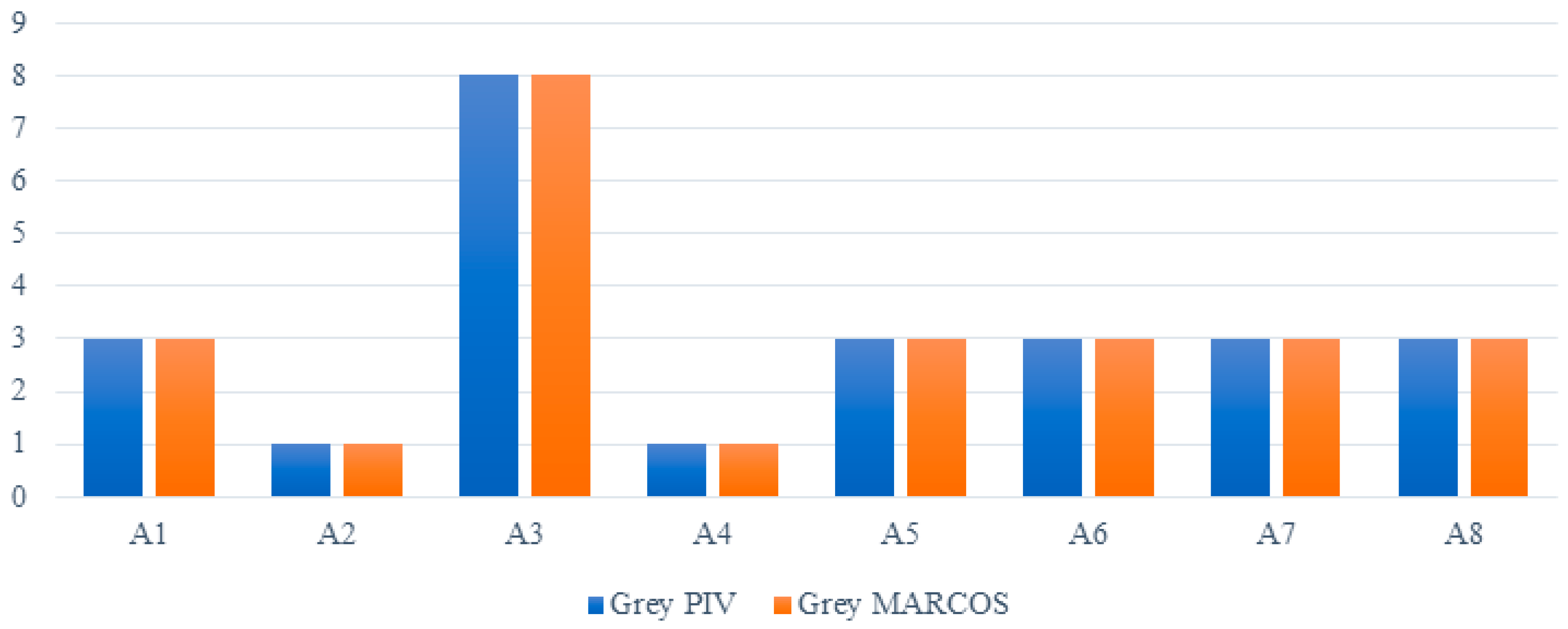
The results highlight the prioritization of Ruta 5 Norte con Suecia Avenue (A2) and J.J. Pérez with Gerónimo Méndez (A4) as the top choices in the conducted research. Additionally, Ruta 5 Norte with Los Clarines Avenue (A3) is positioned at the bottom of the prioritization process. This discernment provides a clear and concise overview of the hierarchical arrangement of the research options based on this study’s evaluation criteria.
3.2.3. Sensitivity Analysis
A comparative analysis employing grey MARCOS was conducted to evaluate the robustness of the innovative hybrid MCDM technique proposed in this study. This assessment involves a comparison between the outcomes obtained through grey PIV and those achieved using grey MARCOS. The findings of this comparative analysis are presented in
Table 8, which showcases the final results derived from both the grey PIV and grey MARCOS methodologies. This rigorous evaluation aims to provide insights into the reliability and effectiveness of the novel hybrid MCDM technique, offering a comprehensive perspective on its performance in comparison to established approaches such as grey PIV and grey MARCOS.
Table 8.
Results of grey PIV and grey MARCOS.
Table 8.
Results of grey PIV and grey MARCOS.
| | Grey PIV | Grey MARCOS |
|---|
| A1 | 3 | 3 |
| A2 | 1 | 1 |
| A3 | 8 | 8 |
| A4 | 1 | 1 |
| A5 | 3 | 3 |
| A6 | 3 | 3 |
| A7 | 3 | 3 |
| A8 | 3 | 3 |
Moreover,
Figure 3 visually illustrates the contrast between the results obtained from the grey PIV and grey MARCOS methodologies. This graphical representation serves to enhance the understanding of the comparative analysis, offering a clear and concise depiction of the differences in outcomes between the two techniques. By incorporating visual elements, this figure contributes to the comprehensive evaluation of the novel hybrid MCDM approach introduced in this research, providing stakeholders and researchers with a nuanced insight into the performance distinctions between grey PIV and grey MARCOS.
Additionally, a rigorous analysis using the Pearson correlation coefficient test was conducted to further scrutinize the efficacy of the grey PIV and grey MARCOS methodologies. The outcomes of this examination, revealing the degree of correlation between the results obtained from grey PIV and grey MARCOS, are succinctly presented in
Table 9. This statistical evaluation enhances the robustness of the assessment, providing a quantitative measure of the relationship between the two methods and contributing valuable insights into their comparative performance.
The results indicate that the novel grey RANCOM-PIV is completely robust and trustable.
From a methodological perspective, the designed methodology can deal with the uncertainty of decision making and the ambiguities of determining the importance of measures. One of the advantages of grey RANCOM model development is its means of handling uncertainties in decision-making problems, which are considered by determining the upper and lower bounds of a specific interval to determine the importance of rules. This novel grey PIV method could prioritize the options with satisfactory accuracy and robust sensitivity analysis. Grey PIV benefits from linear normalization in putting the primary data on the same scale. Moreover, the overall proximity value procedure benefits from the whitening degree in obtaining the final scores.
4. Discussion
The findings derived from this specific case study have broader implications that can be applied to cities worldwide. Enhancing community connectivity is crucial, and communities stand to gain significant benefits by improving street connectivity and facilitating pedestrian access across the city. The quality of the pedestrian environment is paramount, influencing well-being, safety, ergonomic considerations, and adaptation to climatic conditions.
This study addresses the issue of ambiguity in problem solving and experts’ opinions regarding the significance of criteria. To validate our research methodology, we have employed two newly introduced MCDM techniques—grey RANCOM and grey PIV. To verify the trustworthiness of grey PIV results, grey MARCOS is utilized, and its results are compared to those of grey PIV. The comparison showed that the newly introduced grey PIV is accurate in assessing the research options.
Encouraging non-motorized transportation, particularly walking, is not only an eco-friendly alternative but also holds greater significance than merely a recreational activity. Promoting pedestrian-friendly environments becomes imperative because citizens extensively utilize urban spaces to access various services.
Establishing safe pedestrian routes, safeguarding physical integrity, and minimizing direct contact with motorized vehicles are essential. Pedestrian bridges emerge as a viable solution, offering a dual advantage by enhancing both vehicular traffic flow and pedestrian safety.
Urban development embracing sustainability, reducing ecological footprints, and ensuring long-term economic viability becomes a magnet for tourism. The ease of access to different points of interest within the city positions it as an attractive destination for visitors. The impact of such designs, especially those incorporating pedestrian bridges, should be evaluated considering the associated costs, including architectural definition, material selection, and labor.
From a facilities engineering and urban planning perspective, key criteria such as connectivity, comfort, integration, tourist attraction, and traffic flow should guide decisions regarding pedestrian points in a city.
The proposed mathematical model provides a sophisticated decision-making tool that accounts for subjective opinions through the incorporation of grey theory in the evaluation process. The grey RANCOM model, with its global weights, proves instrumental in discriminating between various investment alternatives for constructing pedestrian bridges. The grey PIV model identifies Route 5 North with Suecia Avenue and J.J. Pérez with Gerónimo Méndez as the most relevant alternatives. Further validation through the grey MARCOS model’s sensitivity analysis solidifies the credibility of the results and the proposed model.
As the field continues to evolve, future research should focus on overcoming existing challenges and refining MCDM models to better address the unique complexities of pedestrian path planning. The literature underscores the need for ongoing exploration, with the potential for innovative applications and improvements in decision-making processes.
In conclusion, the integration of MCDM in pedestrian path planning is a pivotal step toward achieving sustainable and user-friendly urban environments. This literature review provides a foundational understanding of the role of MCDM in addressing the complexities of pedestrian path optimization.
In this study, we introduced a cutting-edge hybrid MCDM model, uniquely combining elements from grey Relational Analysis with Network Analysis Process (RANCOM), grey Principal Ideal Vector (PIV), and grey Multiple Attribute Ratio Analysis using the COmpromise Solution (MARCOS). This novel approach capitalizes on the strengths of each individual model, offering a robust framework for addressing complex decision-making scenarios in this specific context.
Furthermore, as the field of MCDM continues to evolve, we anticipate that new and innovative models will emerge to further enhance the efficacy of decision-making processes. In this study, the integration of diverse methodologies, like the grey RANCOM, grey PIV, and grey MARCOS, demonstrates the potential for hybrid models to provide comprehensive solutions. We posit that developing novel MCDM models will not only cater to the intricate nature of decision-making challenges but also contribute to the advancement of sustainable and optimized solutions. Our study serves as a testament to the dynamic nature of MCDM research, paving the way for future advancements in tackling complex decision-making models and improving the overall decision-making landscape.
5. Conclusions
In conclusion, this study introduces a novel mathematical model aimed at guiding decisions that prioritize pedestrians as central figures in urban life, ultimately contributing to sustainable urban planning. The intricate nature of decisions in urban development, particularly those involving numerous subjective criteria and significant financial investments with far-reaching impacts on cities, presents a formidable challenge for decision makers, as exemplified by the case study presented in this work.
The employment of mathematical models not only offers a structured approach but also provides an objective framework for municipalities worldwide. This decision modeling procedure is adaptable to cities of varying sizes and can be applied across diverse territorial landscapes, presenting a universally applicable solution.
Looking ahead, future endeavors in this domain could extend the application of MCDM techniques to identify optimal locations for pedestrian traffic signals. This would aid in regulating the interaction between vehicular traffic and pedestrian flow, including the design and construction of intricate pedestrian crossing underpasses.
On a criteria front, the wealth of currently managed data presents an opportunity to incorporate predictive assessments of factors such as crossing time, waiting time, or driving speed. Leveraging machine learning techniques could enhance our ability to determine the influence of these factors, contributing to more informed decision making in urban planning.
Moreover, the evolving landscape of urban development should take into account the integration of autonomous vehicles and their interactions with pedestrians. Exploring this aspect could pave the way for future studies investigating the role of mathematical decision-making models in optimizing vehicle control systems without human drivers.
In essence, this study not only offers a practical solution for current urban development challenges but also provides a foundation for future research endeavors, encouraging a continuous evolution towards smarter, more sustainable, and pedestrian-centric cities.


 ,
, 


