Review

Progress in the Research of Features and Characteristics of Mountainous Rural Settlements: Distribution, Issues, and Trends

by
Ende Yang
1,2,
Qiang Yao
1,3,*,
Bin Long
1,
Na An
3 and
Yu Liu
4
1
School of Architecture and Urban Planning, Chongqing University, Chongqing 400045, China
2
School of Humanities and Arts, Chongqing University of Science & Technology, Chongqing 401331, China
3
College of Architecture and Urban Planning, Tongji University, Shanghai 200092, China
4
Xinjiang Jialian Urban Construction Planning and Design Research Institute, Urumchi 830002, China
*
Author to whom correspondence should be addressed.
Sustainability 2024, 16(11), 4410; https://doi.org/10.3390/su16114410
Submission received: 31 March 2024 / Revised: 19 May 2024 / Accepted: 20 May 2024 / Published: 23 May 2024

Abstract

:
The study of Features and Characteristics of Mountainous Rural Settlements (RFCMRS) is a key factor in the development of rural settlements during the urbanization process. Mountainous rural settlements, due to their unique mountainous conditions, climate, living environments, and regional culture, are among the important subjects of research for governments and the academic community worldwide. This paper, utilizing the knowledge mapping software CiteSpace (6.2.R3) for co-citation and collaboration analysis, keyword clustering, keyword time zoning, and keyword emergence, analyzes the research trajectory, key issues, and future trends of RFCMRSs. The study finds that current RFCMRS research can be categorized into the following three key issues: “implications of climate change: risks and adaptive responses”, “regional cultural heritage and economic development”, and “ecological conservation and fostering harmonious symbiosis”. Future research will focus on the following three development trends: “risk response based on climate resilience and ecological protection”, “factors of features and characteristics based on regional culture and landscape configurations”, and “human settlements based on low-carbon objectives and sustainable development principles”. Lastly, the paper proposes the following three future research suggestions: “improving the evaluation system for features and characteristics of mountainous rural settlements”, “deepening the study on the evolutionary phenomenon and mechanism for features and characteristics of mountainous rural settlements”, and “exploring the design methods for features and characteristics of mountainous rural settlements based on the concept of sustainable development”.

Graphical Abstract

1. Introduction

Mountains cover 24% of the Earth’s land surface, yet they provide over 70% of the planet’s freshwater resources (which can exceed 90% in arid and semi-arid regions) and a significant portion of energy, mineral resources, and ecosystem services [1]. During the 2000 United Nations General Assembly, three international environmental research programs, the International Geosphere−Biosphere Programme (IGBP) [2], the International Human Dimension of Global Environmental Change Programme (IHDP) [3], and the Global Terrestrial Observing System (GTOS) [4], jointly launched the “Global Change and Mountains: Mountain Research Initiative (MRI)” [5]. Subsequently, the ecological environment of mountainous areas, along with regional and ethnic cultures and their impact on human settlements, began to receive widespread attention globally, leading to a surge in both theoretical and practical research on the features and characteristics of mountainous rural settlements. In this context, the strategic significance of the development of mountainous rural settlements for regional security and sustainable development gradually became recognized [6,7], and the Research of Features and Characteristics of Mountainous Rural Settlements (RFCMRS) has become one of the key areas of focus for governments and the academic community in various countries.
From the perspective of human settlement studies, rural settlements are considered an equivalent concept to urban settlements and represent an important type of human habitat [8]. Rural settlements serve as the basic carriers of population and space in traditional agricultural societies and form fundamental social spaces according to the needs of production and daily life [9]. Meybeck, M. et al. classify landform types into six types, (namely, plains, lowlands, platforms, hills, plateaus, and mountains) according to topographic roughness and elevation and describe their constraints on human settlements. Among these, mountains can be further categorized into low-altitude and mid-altitude (500–2000 m), high-altitude (2000–4000 m), and extremely high-altitude (4000–6000 m) regions [10]. Considering the suitability of human habitation, the mountainous rural settlements discussed in this paper are mainly located in hilly, low-altitude, and mid-altitude landforms. Over time, rural settlements have gradually developed distinctive local characteristics that adapt to the local natural environment and regional culture, referred to as features and characteristics of mountainous rural settlements. These features and characteristics are manifested in the various material and non-material elements of rural settlements, including site layout, landscape patterns, spatial forms, architectural styles, production and daily life practices, historical and cultural aspects, folklore, and religion [11]. Mountainous rural settlements are places of human habitation within specific mountainous geographical environments. Their formation is a result of human adaptation to land factors, climate conditions, and ecological environments to meet their own needs. Mountains are hubs of landscape diversity and biodiversity [12], with sensitive and fragile ecological environments. The unique ecological and geographical conditions of mountains can influence the following five aspects of rural settlements: housing styles, settlement locations, settlement forms, settlement sizes, and settlement categories [13]. The fragmented topography of mountainous areas and the geospatial isolation and fragility of mountain ecosystems have given rise to sharp conflicts in the human−land relationship [14]. Currently, RFCMRS research encompasses various aspects, including connotation and characteristics, evaluation systems, technical methods, protection and renewal, and design practices. It has developed into an important international, interdisciplinary, and multi-perspective research field with broad research value.
As a result, mountainous rural settlements often exhibit characteristics such as low population density, close-knit social structures, and high dependence on local resources. In the ICOMOS “Principles concerning rural landscapes as heritage”, 2017 [15], rural landscapes are defined as “terrestrial and aquatic areas co-produced by human−nature interaction used for the production of food and other renewable natural resources, via agriculture, animal husbandry and pastoralism, fishing and aquaculture, forestry, wild food gathering, hunting, and extraction of other resources, such as salt. Rural landscapes are multifunctional resources. At the same time, all rural areas have cultural meanings attributed to them by people and communities: all rural areas are landscapes”. Based on the influencing factors and characteristics of mountainous rural settlements, this paper defines “Mountainous Rural Settlement Characteristic Landscape” as follows: “Rural settlements located in mountainous regions that have spontaneously developed distinct characteristics over the long term, which are distinct from other geographical types of rural settlements. These characteristics emerge through the adaptation to specific natural environmental factors such as terrain, climate, water sources, altitude, slope, soil, and vegetation, as well as the influence of social and human factors such as regional culture, economy, population, policy systems, production, and lifestyle”.
Research on the characteristic landscape of mountainous rural settlements has a long history. Researchers have explored the focuses and advancements in various disciplines such as architecture, urban and rural planning, landscape architecture, and rural geography in the study of rural settlement characteristic landscapes [11]. RFCMRS is one of the research branches focusing on rural settlement characteristic landscapes under specific geographical conditions. Since the mid-20th century, countries such as the former Soviet Union, the United States, China, Canada, Japan, Mediterranean countries, and others have conducted continuous and systematic research on the scientific and technical aspects of the characteristic landscape of mountainous rural settlements. RFCMRS research not only emphasizes the improvement and optimization of the quality of settlement space, architecture, and landscapes but also delves into issues related to population growth, resource utilization, ecological balance, and sustainable development. The research content of RFCMRS can generally be categorized into two perspectives, human habitat and ecology and landscape, involving elements that influence the characteristic landscape of mountainous rural settlements, formation mechanisms, protection strategies, renewal strategies, and design methods.
From the perspective of Human Settlements Environmental Science [16], a multidisciplinary group centered around architecture and urban planning has been established within RFCMRS. This multidisciplinary group primarily focuses on the influencing factors [17], spatial forms [17], spatial distribution [18], spatial heterogeneity [19], architectural characteristics [17], regional and ethnic cultures [20,21], and land use [22] related to features and characteristics of mountainous rural settlements. Countries worldwide have developed distinctive methods for features and characteristics of mountainous rural settlements design and have improved related legal protection systems, significantly alleviating the urban−rural development conflicts. With the development of human habitation studies, researchers from fields such as architecture, urban planning, and landscape architecture have developed a scientific framework for mountainous human habitats based on mountainous features [23], further enhancing their understanding of features and characteristics of mountainous rural settlements. Viewed from the perspective of mountainous human habitat science, the research on features and characteristics of mountainous rural settlements can be categorized into the following two main themes [17]: (1) The study of the relationship between basic elements of mountainous environments and the development of rural settlement human habitats. The fundamental elements of mountainous environments include terrain, rivers, complex topography, climate, and ecological components [24]. (2) The “Four-in-One” strategy for mountainous human habitat development (urban planning, architecture, landscape architecture, and technical support) has generated new scientific meanings and problem-solving approaches in complex mountainous environments. This encompasses theoretical construction, viewpoint definition, and technical method pathways.
From an ecological and landscape research perspective, researchers from disciplines such as landscape ecology, rural geography, rural settlement studies, and rural sociology have conducted extensive research within RFCMRS, enriching the theoretical framework and methodologies of features and characteristics of mountainous rural settlements. The features and characteristics of mountainous rural settlements constitute a complex ecological system comprising villages, forests, grasslands, farmlands, water bodies, livestock, etc., integrating natural, economic, and social elements [25]. Following the classification based on the functions of rural landscapes, such as economic functions, social functions, ecological functions, and aesthetic functions [26], current research primarily involves the identification, characterization, evaluation, and zoning of the primary functions of different landscape types within mountainous rural settlements, as well as landscape construction. Some researchers have approached the study of mountainous rural settlements from the perspective of landscape ecology, delving into topics like vertical ecological landscapes [27], landscape patterns [28], and ecosystems [29]. Others, viewing it from social and cultural angles, have explored tourism landscape resources [30], cultural landscapes [31], landscape genes [32], and agricultural landscapes [33] in different regions of mountainous rural settlements. They have investigated the natural characteristics, regional characteristics, cultural characteristics, and ethnic characteristics of mountainous rural settlement landscapes and their genetic functions. Additionally, researchers have conducted theoretical and case studies on the multifunctionality of mountainous rural settlement landscapes, mainly covering issues like landscape function identification [34], landscape element assessment [35], planning and design [36], and maintenance and management [37]. Presently, quantitative research has been initiated on mountainous rural settlement landscapes that utilizes ecological and geographical research methods. This includes the wide application of approaches such as the Payment for Ecosystem Services (PES) analysis [38], landscape pattern indices [39], and spatial analysis methods [40] within RFCMRS.
In summary, RFCMRS encompasses multiple disciplines such as architecture, urban and rural planning, landscape architecture, and rural geography, focusing on its influencing factors, protection and renewal strategies, formation mechanisms, and design methods. Various countries, guided by the concept of sustainable development, have formulated unique design methods and legal protection systems. The research content involves the spatial forms, ecological landscapes, cultural characteristics, and resource utilization of mountainous rural settlements.
Mountainous rural settlements are integral to human history and culture, showcasing unique characteristics of both mountainous and rural settings. The features and characteristics of mountainous rural settlements are the result of the interaction of various factors, including topography, ecological environment, socio-economic conditions, regional culture, ethnic culture, production relations, and kinship structures. Throughout their development, these settlements face numerous challenges, such as sensitivity to climate change [41], ecological fragility [42], soil erosion [43], and resource scarcity [44]. Additionally, they encounter socio-economic issues such as the loss of regional culture, architectural homogenization, transformation of traditional lifestyles, and overdevelopment of land. By clarifying the basic characteristics, evolutionary patterns, research topics, and development trends of RFCMRS, this paper not only provides theoretical support for the protection, renewal, and sustainable development of these settlements but also offers guidance for planning and design strategies. This helps decision-makers formulate more scientific and effective development plans, ensuring that mountainous rural settlements retain their unique cultural and ecological value in the process of modernization.
Currently, the RFCMRS has attracted researchers from various disciplines in both natural and social sciences, forming new research hotspots and key issues. However, traditional research methods face significant limitations in handling the vast amount of interdisciplinary and multi-perspective literature data [45]. Firstly, traditional methods often rely on qualitative analysis, making it difficult to fully and systematically reveal the complex relationships and knowledge structures within the literature. Secondly, when dealing with large volumes of data, manual analysis is inefficient and prone to omissions and biases. Thirdly, traditional methods lack the capability to track dynamic changes and the evolution of research hotspots in real-time. Therefore, this paper employs statistical methods and CiteSpace-based bibliometric techniques to analyze the knowledge mapping of the RFCMRS literature included in the Web of Science (WOS) database. By deeply mining and analyzing the literature data, this paper aims to accurately and intuitively grasp the current research progress on the features and characteristics of mountainous rural settlements. This approach not only provides valuable references and suggestions for RFCMRS researchers from different professional backgrounds but also hopes to promote interdisciplinary collaboration, further advancing research in this field. Moreover, it seeks to offer theoretical support and practical guidance for the protection and sustainable development of mountainous rural settlements.

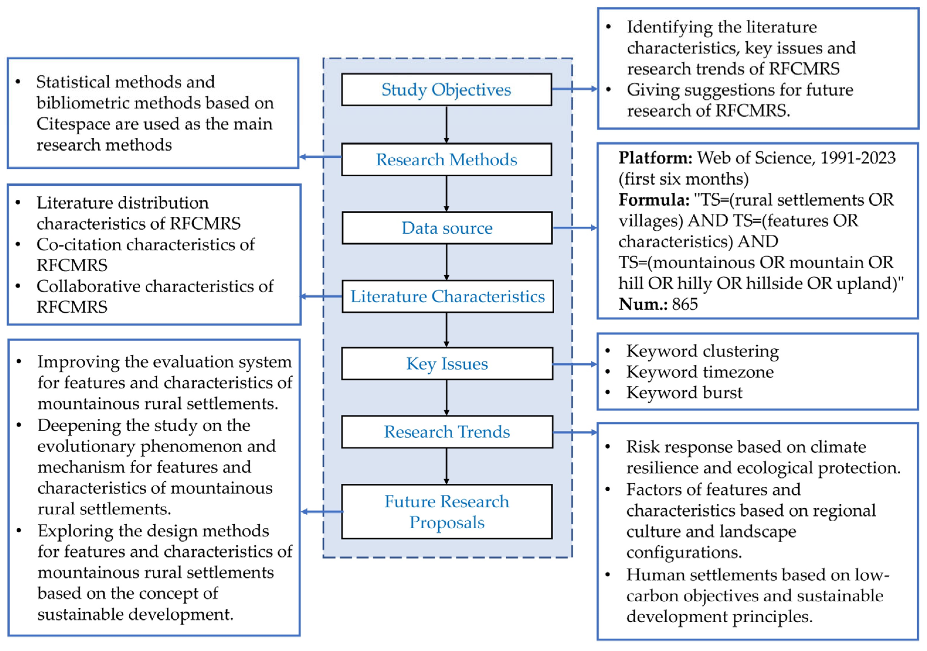
2. Materials and Methods

CiteSpace is a commonly used bibliometric software in scientific research which can detect and identify the knowledge base and forefront hotspots of a certain type of research at a specific time and discover the interconnections between different research fronts [46]. In this study, the Web of Science (hereinafter referred to as WOS) Core Collection was used as the data source for the RFCMRS literature. The literature data were retrieved on June 6, 2023, with the search period spanning from 1975 to 2023. This paper employs a retrieval pattern consisting of “topic” and “document types”, selecting “rural settlements”, “features”, and “mountainous” as the primary keywords. The language of the literature is limited to “English”, and the document type is restricted to “articles”. Considering the variability in language expression, additional search keywords such as “villages”, “characteristics”, “mountain”, “hill”, “hilly”, “hillside”, and “upland” were included to expand the search. Therefore, the final search query is as follows: TS = (rural settlements OR villages) AND TS = (features OR characteristics) AND TS = (mountainous OR mountain OR hill OR hilly OR hillside OR upland). A total of 865 results were obtained from the search, with the earliest published literature dating back to 1991.
By employing the bibliometric software CiteSpace to analyze the 865 RFCMRS literature entries collected from the WOS Core Collection, this study aims to investigate the developmental context, key issues, and trends of RFCMRS. The research framework is illustrated in Figure 1. The distribution characteristics of the RFCMRS research literature are analyzed through the following four aspects: annual publication trends, source disciplines, source publications, and source countries. From the perspectives of journals, literature, and authors, the collaborative characteristics of the RFCMRS literature are examined. Collaborative features of RFCMRS research are assessed based on co-authors, collaborating institutions, and collaborating countries. Key issues of RFCMRS are summarized using CiteSpace’s keyword clustering function. The research context and current hotspots of RFCMRS are elucidated through CiteSpace’s keyword timeline and keyword burst functions. Based on the distribution characteristics, key issues, and research hotspots of the RFCMRS literature, future development trends for RFCMRS are predicted, and priority research recommendations are offered to researchers from various professional backgrounds. To more comprehensively reflect the academic discussions and research dynamics in the RFCMRS field when discussing future development trends of RFCMRS (Section 3.6) and providing research suggestions (Section 4), this paper has utilized a broader range of literature sources not limited to the scope of the WoS Core Database. The search criteria were as follows: (1) Scope and language. We used Google Scholar to search for literature published globally with a language restriction to English. (2) Type of literature. This includes books, conference papers, reports, as well as master’s and Ph.D. theses. (3) Accessibility. We selected resources that are accessible online to ensure quick and effective access to the full text of the literature. (4) Publication year. This element was restricted to 1991–June 2023 to maintain consistency with the WoS search results. (5) Search keywords. In Google Scholar, we chose the “with all of the words” advanced search option, selecting “rural settlements”, “features”, and “mountainous” as the basic keywords; additionally, depending on the different research contents, the extended keywords included “climate resilience”, “regional culture”, and “sustainable development goals”.
The analysis of co-citation expresses the number of times two documents are cited together [47,48]. Researchers from different institutions or countries/regions serving as authors of the same paper constitute collaborative relationships. In this paper, the collaborative relationships among numerous paper authors in a specific research field are referred to as a collaboration network [49]. Centrality is a method for measuring the likelihood that paths in a collaboration network or co-citation network pass through nodes (authors or documents). The concept primarily includes two parts: node centrality and betweenness centrality [50]. Node centrality is a graph theory concept used to quantify the importance of a node’s position within a network [50]. Betweenness centrality is a commonly used centrality measure. It refers to the ratio of the number of shortest paths that pass through a given node and connect two other nodes to the total number of shortest paths between those two nodes [51]. Keyword co-occurrence analysis involves analyzing the keywords provided by authors in the dataset [49]. Temporal partition analysis highlights the temporal patterns between research hotspots and their knowledge base (such as keywords and clusters) in a particular research field, with time zones being arranged chronologically from left to right. Burst keyword analysis is used to discover keywords in a specific research field that experience a significant increase in frequency during a certain time period [46].

3. Results

In this chapter, the following four main research focuses are included: literature characteristics, key issues, research hotspots, and research trends. The sections on literature distribution, co-citation, and research collaboration for RFCMRS (Section 3.1, Section 3.2 and Section 3.3) are inclined towards describing the publication status, citation, and collaboration features of the research literature. This serves as a prerequisite for the subsequent analysis of keyword clustering and key issues (collectively referred to as the research landscape). By analyzing the co-occurrence of high-frequency keywords, keyword clustering, and temporal partitions for RFCMRS, the main research clusters are identified and the evolution of these clusters is analyzed (Section 3.4.1). Based on this analysis, key issues are further summarized (Section 3.4.2). After clarifying the research landscape of RFCMRS, recent research hotspots are determined through keyword temporal partitions and keyword burst analysis (Section 3.5). By combining existing relevant policies from various countries, the chapter concludes with a comprehensive assessment of the potential major research trends in this field in the coming years (Section 3.6).

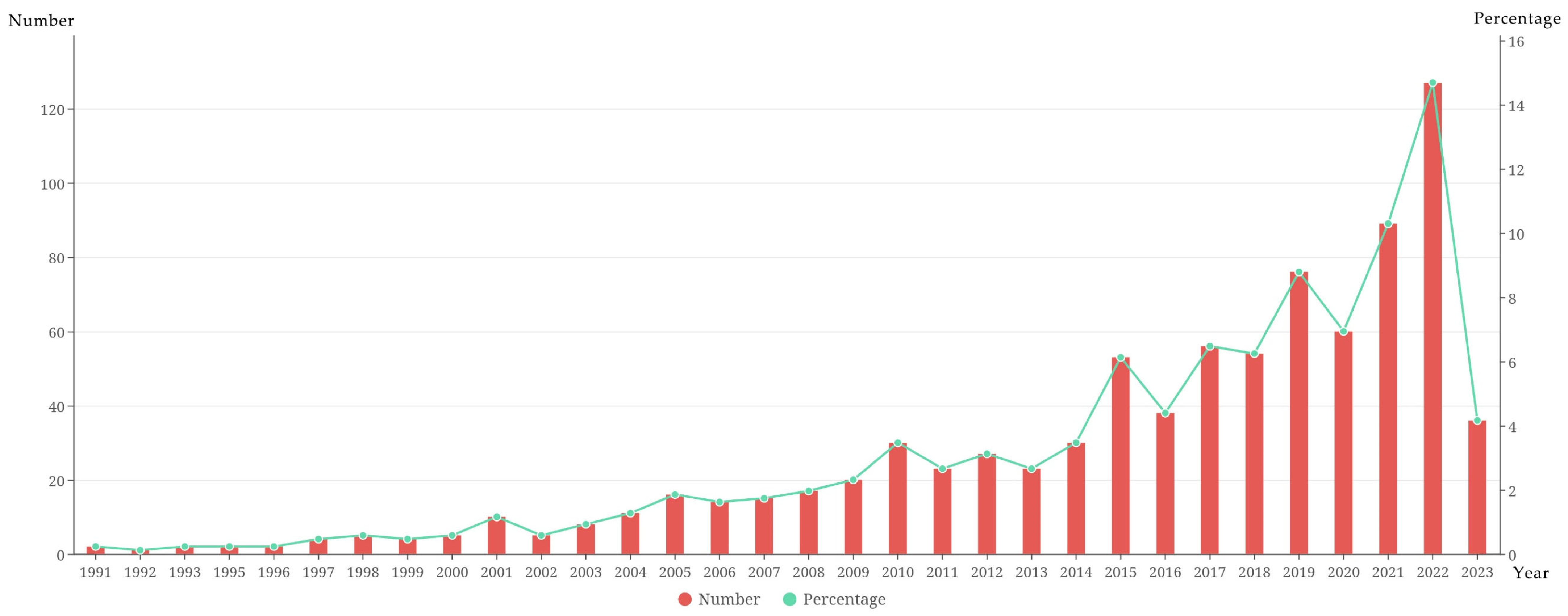
3.1. The Literature Distribution Characteristics of RFCMRS

This subsection interprets the literature distribution of RFCMRS based on the basic statistical data from the WOS Core Collection through the following four aspects: annual publication volume, source disciplines, source publications, and source countries. It has been found that the RFCMRS literature overall exhibits characteristics of continuous growth, interdisciplinary participation, and international collaboration.

3.1.1. Annual Publication Trend of RFCMRS

Based on the basic statistical data of the RFCMRS literature in the WOS Core Collection, this paper interprets the distribution of literature via the following four aspects: annual publication volume, source disciplines, source publications, and source countries. According to the annual publication volume data, the number of publications from RFCMRS exhibits an overall trend of sustained growth (Figure 2). The study commenced the search for potential publications starting from the year 1975; however, the first definitive publication did not emerge until 1991. In particular, the period from 1991 to 2000 had a relatively low share of RFCMRS literature publications (only 3.12% of all the research literature), with an average annual publication volume of only three papers. Therefore, it can be considered that RFCMRS research at this stage did not receive sufficient attention. From 2001 to 2014, the amount of RFCMRS literature remained stable, with an average annual publication volume increasing to 18 papers. The period from 2015 to 2022 showed fluctuating growth in RFCMRS publications, with an average annual publication volume of 67 papers. In 2022, it reached a historical high (approximately 14.68% of the total publications). As of 6 June 2023, there were a total of 865 RFCMRS literature entries in the WOS Core Collection. Among them, the number of publications in 2020, 2021, and 2022 was 60, 89, and 127, respectively. The number of publications in the first six months of 2023 was 36, and it is estimated that the total publications in 2023 will be around 100. It should be noted that, with the increasing annual attention to RFCMRS, more research outcomes are expected to emerge in the future.

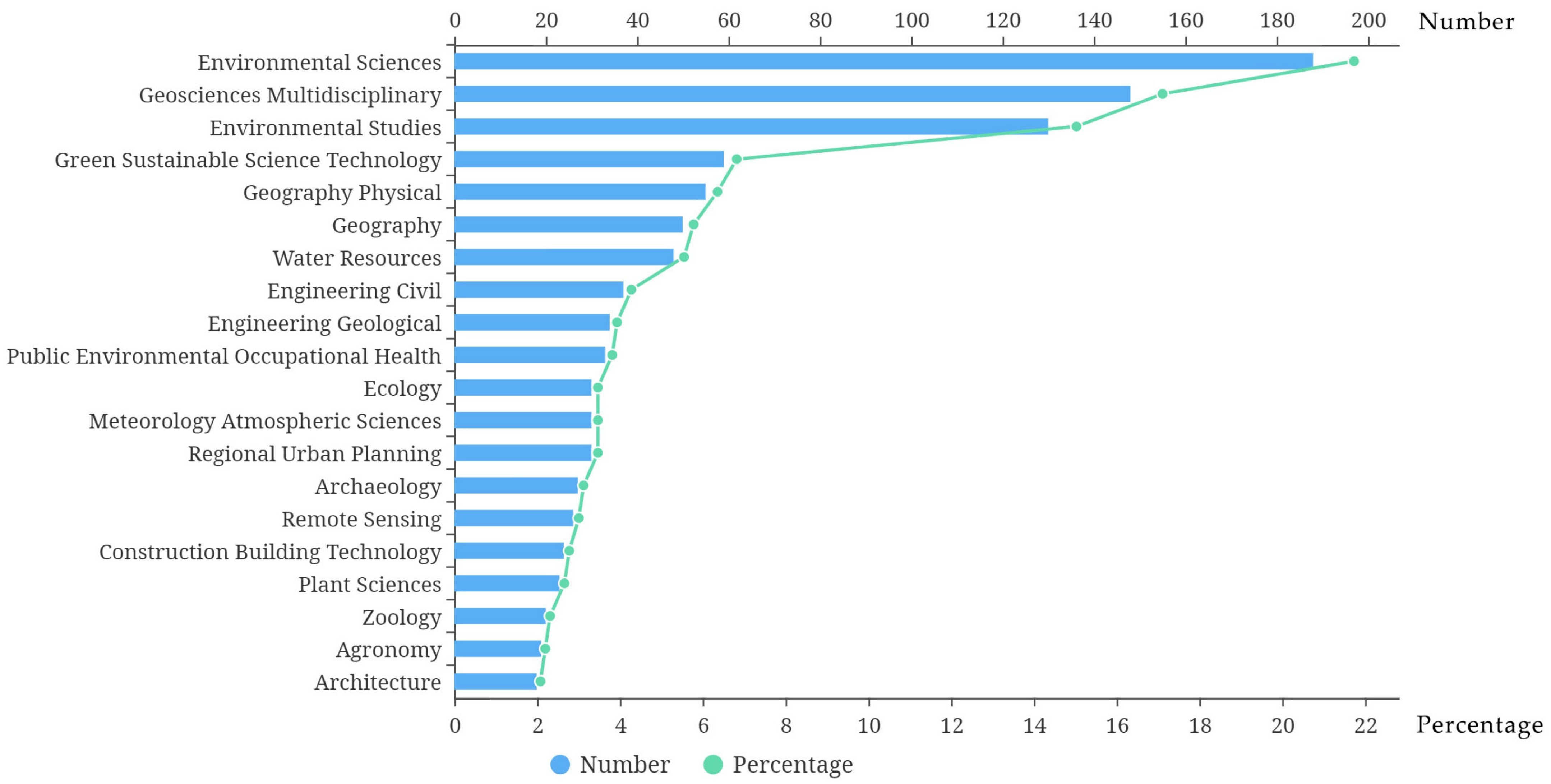
3.1.2. Source Disciplines of RFCMRS Literature

Based on the WOS subject classifications, Environmental Sciences, Geosciences Multidisciplinary, and Environmental Studies are the top three disciplines with the highest number of publications in RFCMRS research, accounting for 21.7%, 17.1%, and 15.0% of the total publications, respectively. Additionally, Green Sustainable Science Technology (6.82%), Geography Physical (6.36%), Water Resources (5.55%), Engineering Civil (4.28%), Engineering Geological (3.93%), Ecology (3.47%), Regional Urban Planning (3.47%), Archaeology (3.12%), and Architecture (2.08%) are among the other disciplines that have contributed to RFCMRS research. It can be observed that RFCMRS encompasses a wide range of disciplines, with the majority of them publishing fewer than 50 papers each. Only the top three disciplines have published more than 100 papers each (Figure 3).

3.1.3. Source Publications of RFCMRS Literature

According to the WOS search results, RFCMRS has publications in a total of 586 different source publications. The journal with the highest number of publications is “Sustainability” (4.74% of the total), followed by “Land” (3.12%), “The Journal of Mountain Science” (1.50%), “International Journal of Environmental Research And Public Health” (1.39%), “Land Use Policy” (1.39%), and “Landslides” (1.39%). The H-index reflects a journal’s impact and research output. Among the source publications of RFCMRS, the journal with the highest H-index is “Sustainability”, with an H-index of 41, followed by “Land” (H-index = 27) and “The Journal of Mountain Science” (H-index = 13). Most of the journals have an H-index not exceeding 10. “Geomorphology” also contributes 1.39% to the publications. The top 10 journals collectively account for approximately 17.5% of the total publications. It can be seen that the journals with higher numbers of publications are mainly concentrated in the fields of environment, geography, and geology, which are directly related to the geographical characteristics of mountainous rural settlements (Figure 4). For journals ranked 8th and beyond, the percentage of publications is less than 1%.

3.1.4. Source Countries of RFCMRS Literature

Based on the source country data from WOS, Figure 5 and Table 1 display the number and percentage of RFCMRS publications in various countries. China (since 1991) and Syria (since 1991) were the first two countries to initiate RFCMRS research. They were followed by the United States (since 1992), Israel (since 1993), and Vietnam (since 1993), all of which made contributions to the early stages of RFCMRS research. China has seen a rapid increase in their number of RFCMRS publications since 2015 (15 publications). In 2022, 75 publications were released, and, in the first six months of 2023, 43 publications were released, with an estimated total of over 80 publications for the full year 2023. Based on the statistical analysis, it can be observed that, currently, China has contributed the most RFCMRS research publications, accounting for 35.376% of the total publications. The United States (8.21%), Italy (7.75%), India (6.82%), and Japan (5.78%) follow as the next top contributors. The top five countries by publication volume have collectively published 553 RFCMRS publications, accounting for 63.93% of the total publications. These data clearly demonstrate the key role of these countries in advancing the RFCMRS field.

3.2. Analysis of Co-Citation Characteristics of RFCMRS

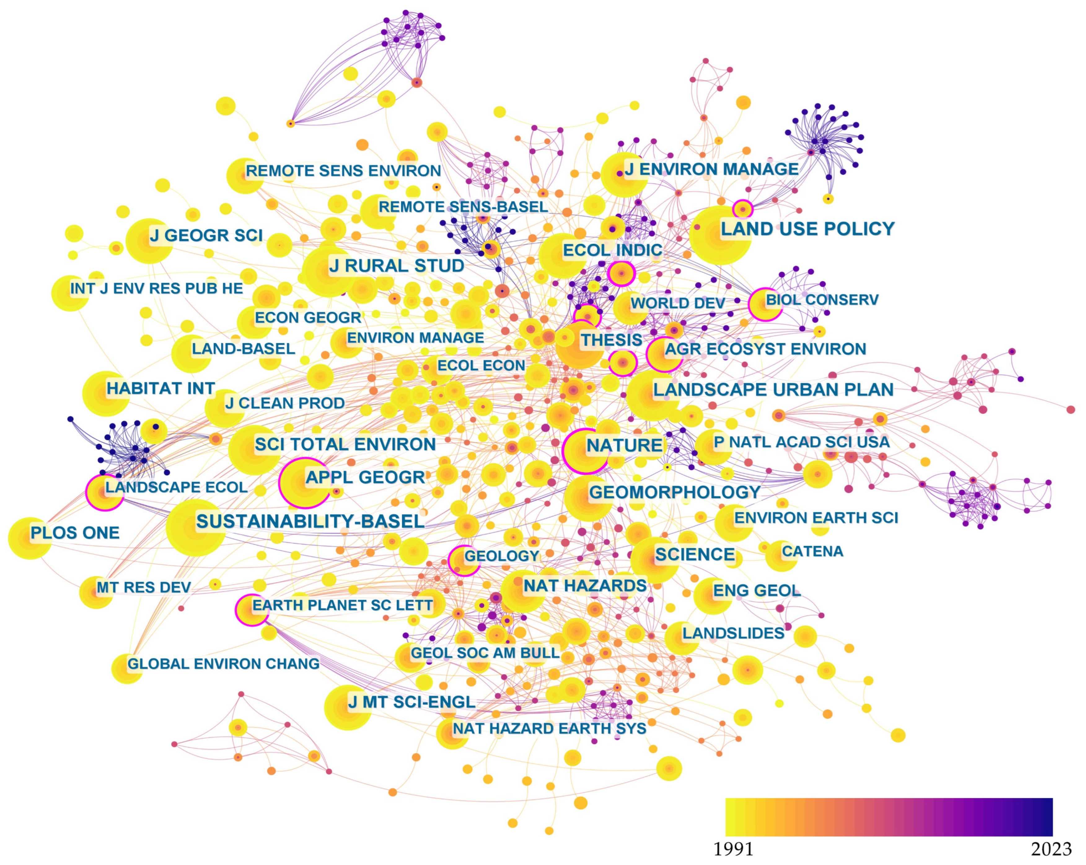
3.2.1. Co-Citation Journals

The shared citation function of CiteSpace is an effective method for analyzing the core journals and disciplinary attributes in a specific research field, using the number of shared citations as a criterion for judging the importance of journals [52,53]. Figure 6 illustrates the shared citation relationships among the primary journals in RFCMRS. In general, there are close shared citation connections among RFCMRS journals and multiple core shared citation networks. In the figure, nodes represent various journals that publish RFCMRS articles, and the lines between nodes indicate shared citation relationships. The size of the nodes is proportional to the number of citations for a specific journal. Journals with strong centrality are outlined in pink, indicating their importance in RFCMRS. Table 2 further lists the top 20 journals in RFCMRS research, with more than 50 shared citations. Among them, “Land Use Policy” (with 123 shared citations), “Sustainability-Basel” (with 112 shared citations), and “Journal of Rural Studies” (with 103 shared citations) have the highest number of shared citations, making them the main journals for publishing high-quality RFCMRS articles. The journal with the highest centrality was “Nature” in 1998 (0.18), followed by “Agriculture, Ecosystems and Environment” (0.17). Additionally, interdisciplinary journals like “Science” and “Proceedings of the National Academy of Sciences of the United States of America (P Natl Acad Sci USA)” also have high shared citation counts and centrality.
Through journal shared citation analysis, it can be observed that RFCMRS has a substantial number of publications and citations in various specialized journals, including land use, rural studies, landscape and urban planning (Landscape Urban Plan), and applied geography. It has also been published in interdisciplinary journals such as “Nature”, “Science”, and “PLoS ONE”, indicating its interdisciplinary research characteristics.

3.2.2. Co-Citation Literature

Co-citation analysis is a method for identifying the core literature in a particular research field at a certain stage [55].The higher the co-citation frequency of a paper, the more likely it is to be foundational or innovative in the research. Using CiteSpace software, this study has generated a visualization map of the 865 RFCMRS papers in the Web of Science (WOS) core database. Based on the primary authors and publication years of papers co-cited more than five times, a co-citation network has been constructed (as shown in Figure 7). In the figure, numerous nodes represent RFCMRS papers in the WOS core database. The size of the nodes is positively correlated with the importance and novelty of the paper, meaning that larger nodes are more important in RFCMRS research. The lines between nodes represent co-citation relationships between RFCMRS papers, and the number of lines reflects the strength of co-citation [56]. Table 3 further lists the top 20 highly co-cited papers in the RFCMRS field, with the most cited paper being a research paper by Liu, Y., and others published in 2017 [57] which has been co-cited 16 times. The earliest highly co-cited paper is a research paper by Yang, R. published in 2016 [58], cited 10 times. The research issues of the top 20 highly co-cited papers are primarily focused on spatial distribution and patterns [59,60,61,62,63,64], rural revitalization [57,65,66], urbanization processes [58,67,68], mountain and hilly environments [69,70], and sustainable development [71,72], among other areas.

3.2.3. Co-Citation Authors

The author co-citation analysis function of CiteSpace can identify the most influential and active authors in a particular research area [77]. Figure 8 shows a co-citation network map of authors who have been cited more than 10 times in RFCMRS research. In the figure, each node corresponds to an author of co-cited papers, and the size of the nodes is proportional to the number of citations. The lines between nodes represent the number of co-citations. Nodes with a red outline indicate authors with high burstiness, meaning their citation frequency suddenly increased within a certain period [78]. Table 4 further lists the top 20 highly co-cited authors in RFCMRS. It can be observed that Long, Hl. is the most cited author (50 times), the second most highly co-cited author is Liu, YS. (44 times), and the research institution FAO (39 times) also has a relatively high number of co-citations. An analysis of the research output of the top 20 highly co-cited authors in Table 4 reveals that RFCMRS primarily encompasses research on the mountain conditions of mountainous rural settlements [79,80,81], spatial patterns [82,83], land use [71,76,84,85,86], and development policies [57,68,85,87,88,89].

3.3. Analysis of the Collaborative Characteristics of RFCMRS

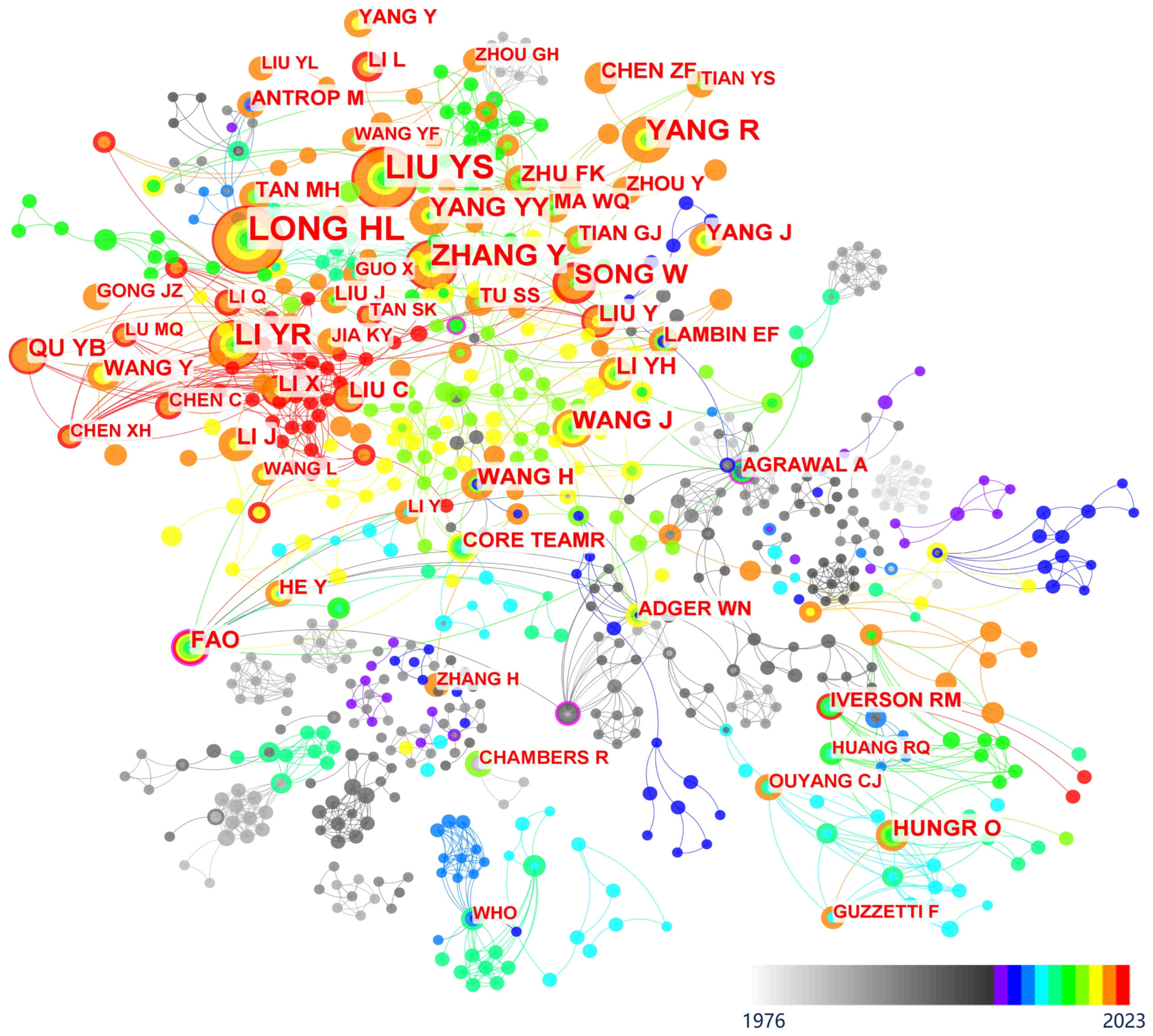
3.3.1. Collaborative Authors and Networks

Research collaboration analysis helps in discovering the network characteristics and degree of collaboration in scientific research. By analyzing the collaborations among authors, institutions, and countries in RFCMRS, we can uncover its research collaboration networks at the micro, meso, and macro levels [11].
At the micro-level of collaboration, Figure 9 displays the research collaboration network of authors in the RFCMRS literature. The size of the nodes represents the number of collaborative publications by the researchers, and the lines between nodes indicate the number of collaborations. From Figure 9, we can see that RFCMRS researchers have formed three relatively large research collaboration networks. The largest collaboration network includes researchers like Guéant-Rodriguez, R.M. and Benamghar, L., with a total of 13 nodes represented in gray. The second and third largest collaboration networks are the blue network, which includes researchers like Shitara, H. and Kobayashi, T. (6 nodes), and the green network, which includes researchers like Winichagoon, P. and Smithers, L.G. (5 nodes). Table 5 lists the top 20 collaborative authors in RFCMRS. Ma, L., with five collaborations in 2022, has the highest number of collaborations. Following closely are Luo, D., Luo, G., and Wang, B., each with four collaborations in 2020.
Notably, the top three authors who published the most collaborative research papers were not significantly involved in the top three ranked collaborative networks, indicating that, at the micro-level, RFCMRS collaborative research largely excludes informal collaborations, potentially leading to incomplete network analysis. Therefore, in the future, RFCMRS researchers and research organizations should strengthen their collaborative links with each other, thus contributing to the publication of more high-quality research results. Future analyses should also consider informal collaborative relationships between authors, such as collaboration on non-published papers, exchanges at academic conferences, and workshop collaborations. This more comprehensive analysis of collaborative networks will help to reveal more in-depth patterns of collaboration in RFCMRS research.

3.3.2. Collaborating Institutions

In Figure 10, the nodes represent collaborative institutions in RFCMRS, and their size is proportional to the number of collaborative research publications. The lines between the nodes indicate academic collaborations between different institutions, and the number of lines reflects the degree of collaboration between institutions.
Table 6 displays the top 20 collaborative institutions in RFCMRS. Looking at the number of collaborative publications (Count), the Chinese Academy of Sciences tops the list with 63 collaborative publications, followed by the University of Chinese Academy of Sciences and the Institute of Geographic Sciences & Natural Resources Research with 28 and 22 collaborative publications, respectively. Centrality represents the importance of research institutions in the collaborative network. Both the Chinese Academy of Sciences and the Institute of Mountain Hazards & Environment have a centrality of 0.09, indicating that these two institutions hold a central position in the RFCMRS collaborative network with close collaborative relationships with other institutions. Institutions such as the French National Center for Scientific Research (Centre National de la Recherche Scientifique, CNRS), with a centrality of 0.05, and the National Institute of Geophysics and Volcanology in Italy (Istituto Nazionale Geofisica e Vulcanologia, INGV), with a centrality of 0.05, are also present in the list. Although these institutions have fewer outputs, they have some research outputs in regard to international co-operation. RFCMRS research at the meso-level exhibits internationalization. The top 20 publishing institutions engaged in collaborative research come from China (14), France (2), Italy (2), the UK (1), and Poland (1). This phenomenon indicates that RFCMRS is an international field of study, with research collaborations existing across various countries.

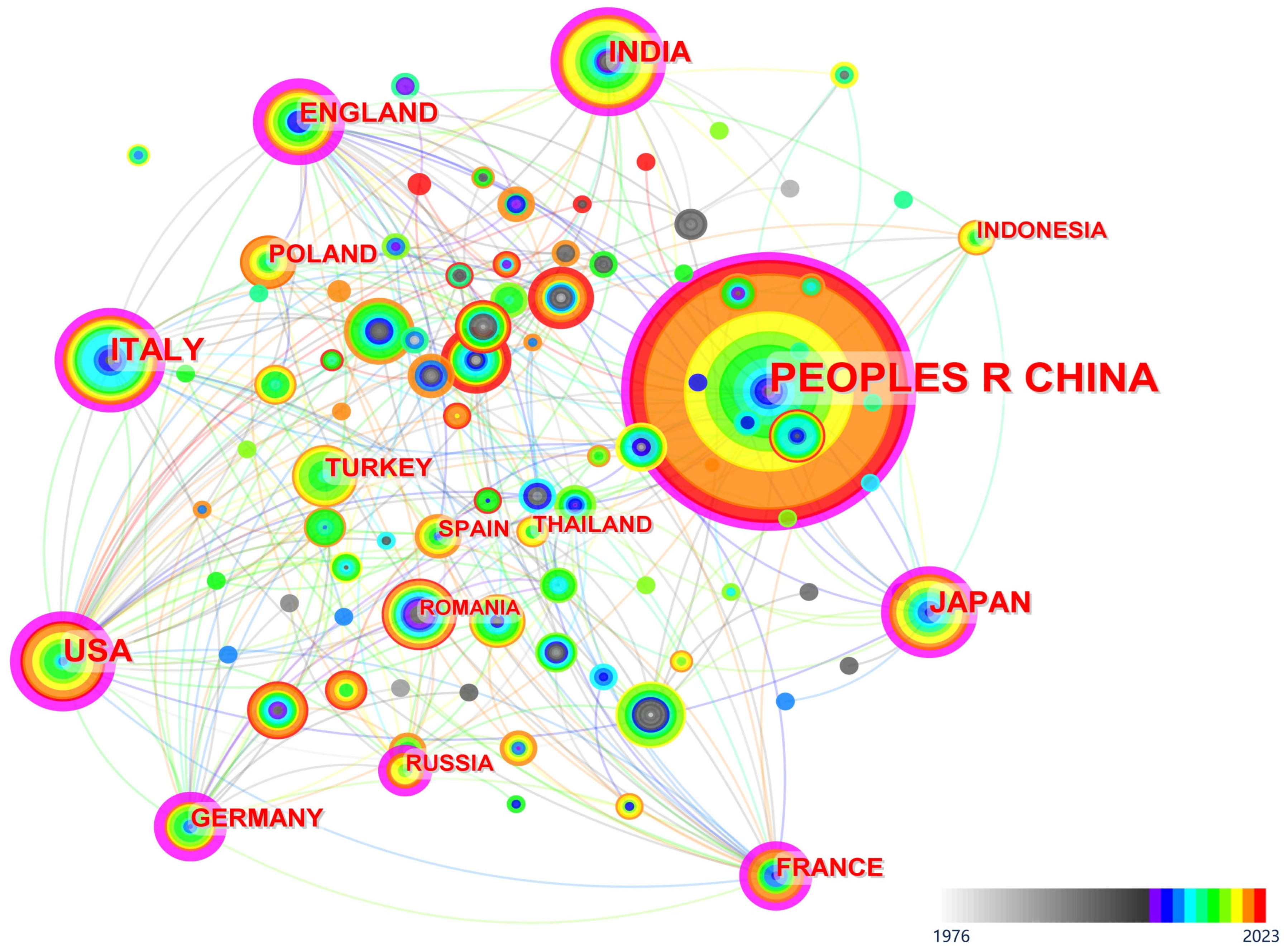
3.3.3. Collaborating Nations

Figure 11 illustrates the collaborative network among different countries in RFCMRS research. Each node in the graph represents a country, and the size of the nodes is proportional to the number of collaborative research papers. Table 7 further lists the top 20 collaborating countries in RFCMRS research, allowing for the following conclusions. China, the United States, and Italy have made the most significant research contributions in the field of RFCMRS. Based on the number of collaborative research papers (Count), China (PEOPLES R CHINA) takes the lead with 265 research papers, followed by the United States (USA) and Italy (ITALY) with 67 and 55 research papers, respectively. Centrality represents a country’s central role in the collaborative network. As shown in Table 7, the United States has a centrality of 0.39 in RFCMRS, indicating its core position in the collaborative network of this research. The United States maintains close collaborative relationships with other countries and achieves a higher citation rate for its published papers. The top five countries in terms of collaboration (China, the United States, Italy, India, and Japan) have jointly published a total of 435 research papers, accounting for 59% of the total collaborative research papers (757 papers) among the top 20 countries. This phenomenon suggests that different countries play distinct roles in the RFCMRS collaborative network, with the top five countries playing pivotal roles in this research area.

3.4. Analysis of RFCMRS Key Issues

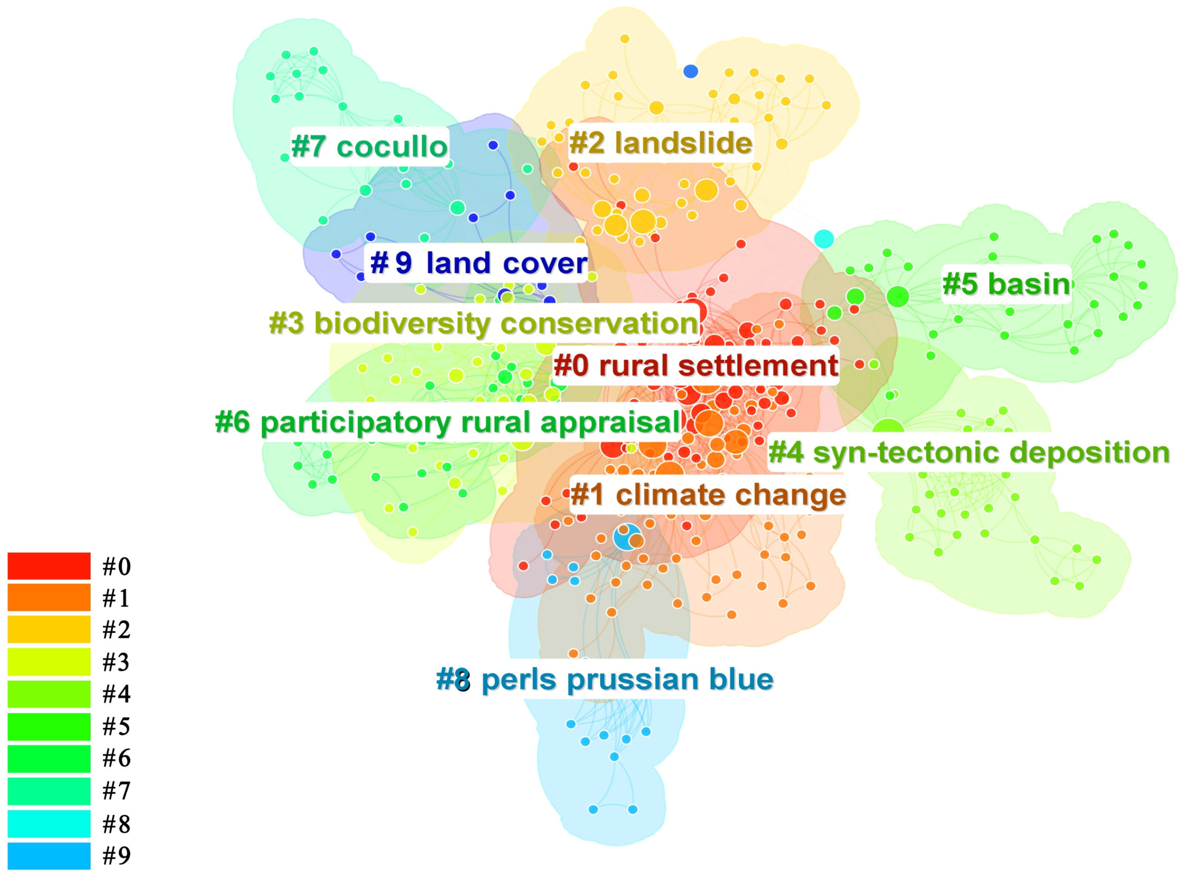
3.4.1. Analysis of Keyword Clusters

The analysis of keyword clusters can condense the co-occurrence network of RFCMRS keywords into a relatively small number of research clusters, aiding in the identification of key issues within a specific research domain [45,91]. Based on the keyword clustering analysis, RFCMRS can be categorized into 10 main clusters, as shown in Figure 12 and Table 8. The modularity value (Q) for RFCMRS is 0.4, and the average silhouette value (S) is 0.7, indicating that most of the clusters are relatively complete and cover a substantial number of publications. The 10 clusters within RFCMRS are “0. rural settlement”, “1. climate change”, “2. landslide”, “3. biodiversity conservation”, “4. syn-tectonic deposition”, “5. basin”, “6. participatory rural appraisal”, “7. Cocullo”, “8. perls prussian blue”, and “9. land cover”. Among these, the cluster with the most keywords is “0. rural settlement”, comprising 83 documents, with keywords including “driving forces”, “China”, and “driving factor”. The cluster with the highest average silhouette value (S = 0.954) is “8. perls prussian blue”, with keywords such as “triticum-turgidum var durum”, “rice”, “variation”, “morphology”.
As can be seen from Figure 13, keyword cluster 8, “perls prussian blue” (1991 to 2021), is the earliest research cluster in RFCMRS. This was followed by cluster 1, “climate change” (1993 to 2023), and cluster 3, “biodiversity conservation” (1996 to 2023). The four to ten emerging research clusters are cluster 5, “basin” (1998 to 2022), cluster 7, “Cocullo” (1998 to 2017), cluster 2, “landslide” (2000 to 2023), cluster 6, “participatory rural appraisal “(2000–2022), cluster 0, ”rural settlement“(2001–2023), cluster 4, “syn-tectonic deposition “(2001–2020), and cluster 9, ”land. cover “(2009–2022).
Analyzing the start and end times of keyword clusters in RFCMRS reveals that clusters “1. climate change” and “8. perls prussian blue” almost span the entire development phase of RFCMRS. Among them, “agricultural production” is a term that highly summarizes the content of clusters 1 and 8, with related keywords including rural livelihoods and rice. Moreover, keywords such as climate change, adaptive capacity, rural landscape, sustainability, and variation also express RFCMRS’ emphasis on climate adaptability and rural landscapes. Clusters “0. rural settlement”, “2. landslide”, and “3. biodiversity conservation”, though emerging later, remain significant areas of research to this day. The key terms of clusters 0, 2, and 3, including driving forces, driving factor, landslide, debris flow, failure mechanism, biodiversity conservation, and habitat, reflect the profound impact of the unique geographical environment of mountains, biodiversity, and geological disasters on the formation and development of the distinct features of mountainous rural settlements. Although cluster “9. land cover” appeared later, it is highly relevant to other clusters’ research content, such as climate change, land use, geological disasters, and biodiversity. Its main keywords, including land cover, hazard, pollution, and teledetection, have garnered continued attention in recent years.

3.4.2. Summary of Key Issues

Through the summary and analysis of keyword clustering in RFCMRS, it is evident that current RFCMRS can be broadly categorized into the following three main research issues: “Implications of Climate Change: Risks and Adaptive Responses”, “Regional Cultural Heritage and Economic Development”, and “Ecological Conservation and Fostering Harmonious Symbiosis”. For the analysis of the connotation and correlation of key issues of RFCMRS, see Table 9.
(1)
Issue of Implications of Climate Change: Risks and Adaptive Responses.
This issue encompasses clusters 1, 5, and 9. Due to the unique topography, mountainous rural settlements are particularly sensitive to climate change. Ongoing climate change can lead to land degradation and the loss of landscape diversity in rural settlements, posing a direct threat to their socio-economic sustainability [92,93]. Researchers have examined the impact of climate change on the distinctive scenery of mountainous rural settlements from perspectives such as adaptation planning [94], collective action [95], and public participation [96]. Ashley, L. et al. proposed Climate Change Adaptation (CCA) planning for mountainous rural settlements in Kyrgyzstan, aiming to enhance their climate resilience by reshaping the rural landscape and implementing sustainable nursery management, thus reducing vulnerability [94]. Orchard, S. et al. explored the impact of Global Environmental Change (GEC) on rural settlements in Marginal Mountainous Areas (MMA) and found that each rural settlement has unique social environmental characteristics, resulting in different developmental challenges, vulnerabilities, and adaptive capacities. Promoting locally tailored collective action can drive rural settlements towards achieving sustainable goals in the context of global environmental change [95]. Shijin, W. et al. analyzed the perceptions of mountain residents regarding climate change and its impacts, revealing that climate change significantly affects the natural and cultural landscapes of mountainous rural settlements. Residents hope to mitigate the effects of climate change through government compensation [96]. Some researchers have also proposed adaptation strategies and mechanisms for RFCMRS under climate change, utilizing community-inclusive approaches to adapt to climate change [97] and mitigate the losses caused by climate-related risks and disasters, such as floods and wildfires [98,99].
(2)
Issue of Regional Cultural Heritage and Economic Development.
This issue encompasses clusters 6 and 7. Mountainous rural settlements, due to their unique geographical location and historical backgrounds, often possess rich cultural heritages. However, with the recent processes of modernization and the rapid development of tourism, many traditional cultural aspects of mountainous rural areas are facing the risk of being lost. Zuo, D. et al. emphasize the importance of traditional knowledge in the preservation of cultural heritage in mountainous rural settlements and propose a bottom-up approach to protect living heritage and adapt to external changes [100]. Esfehani, M.H. et al. argue that traditional architecture, craftsmanship, and intangible cultural heritage in mountainous rural settlements are integral components of rural identity and cultural continuity [101]. Reimer, J.K. et al. find that, while tourism brings economic benefits to rural areas, it also poses a threat to the cultural heritage of mountainous rural settlements [102]. To address this issue, Mu, Q. et al. present a strategy for the revitalization of cultural heritage aimed at promoting citizen participation in mountainous rural settlements to ensure the preservation and inheritance of cultural heritage [103]. Li, G. et al. construct a trans-regional Landscape Network of Traditional Settlements (LNTS) to calculate the core areas of traditional settlement cultural diffusion [104]. Cillis, G. et al. explore sustainable management tools for important cultural heritage represented by rural settlement landscapes and rural architecture [105].
(3)
Issue of Ecological Conservation and Fostering Harmonious Symbiosis.
This issue encompasses clusters 2, 3, 4, and 8. Due to the unique mountainous terrain, the ecosystems of rural settlements are relatively fragile, making them more susceptible to external disturbances and degradation. Wang, Y. et al. point out that spatial planning for mountainous rural settlements plays a critical role in ensuring the harmonious development of mountain ecosystems and human activities [106]. Liu, L. et al. found that cultivated land, grassland, and forest are the primary influencing factors in the evolution of rural settlements, and the interactions between mountainous and aquatic environments, aquatic facilities, agricultural production, and cultural heritage collectively shape the living environment of mountainous rural settlements [28]. Poerwoningsih, D. et al. explore how to integrate multiple aspects, including ecology, culture, and economics, to develop a comprehensive spatial planning approach for mountainous rural settlements [107]. Geographic Information Systems and remote sensing technology also offer recommendations for the landscape ecological stability of characteristic scenery in mountainous rural settlements by identifying the spatial distribution and pattern features of land cover [108]. Furthermore, some researchers provide valuable recommendations for ecological conservation and harmonious coexistence in mountainous rural settlements from the perspective of rural economic transformation and the combination of culture and technology [109,110].

3.5. Analysis of RFCMRS Research Hotspots

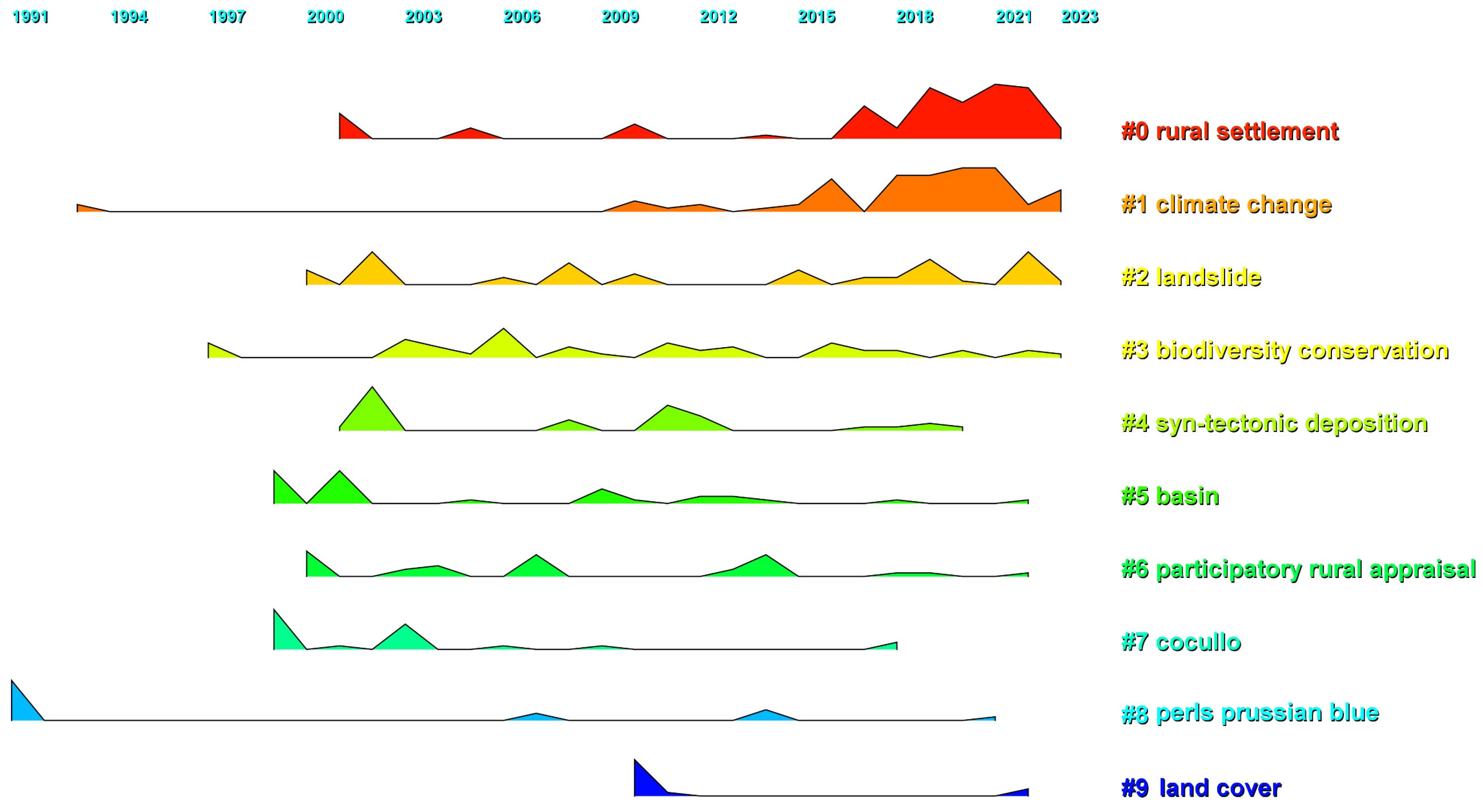
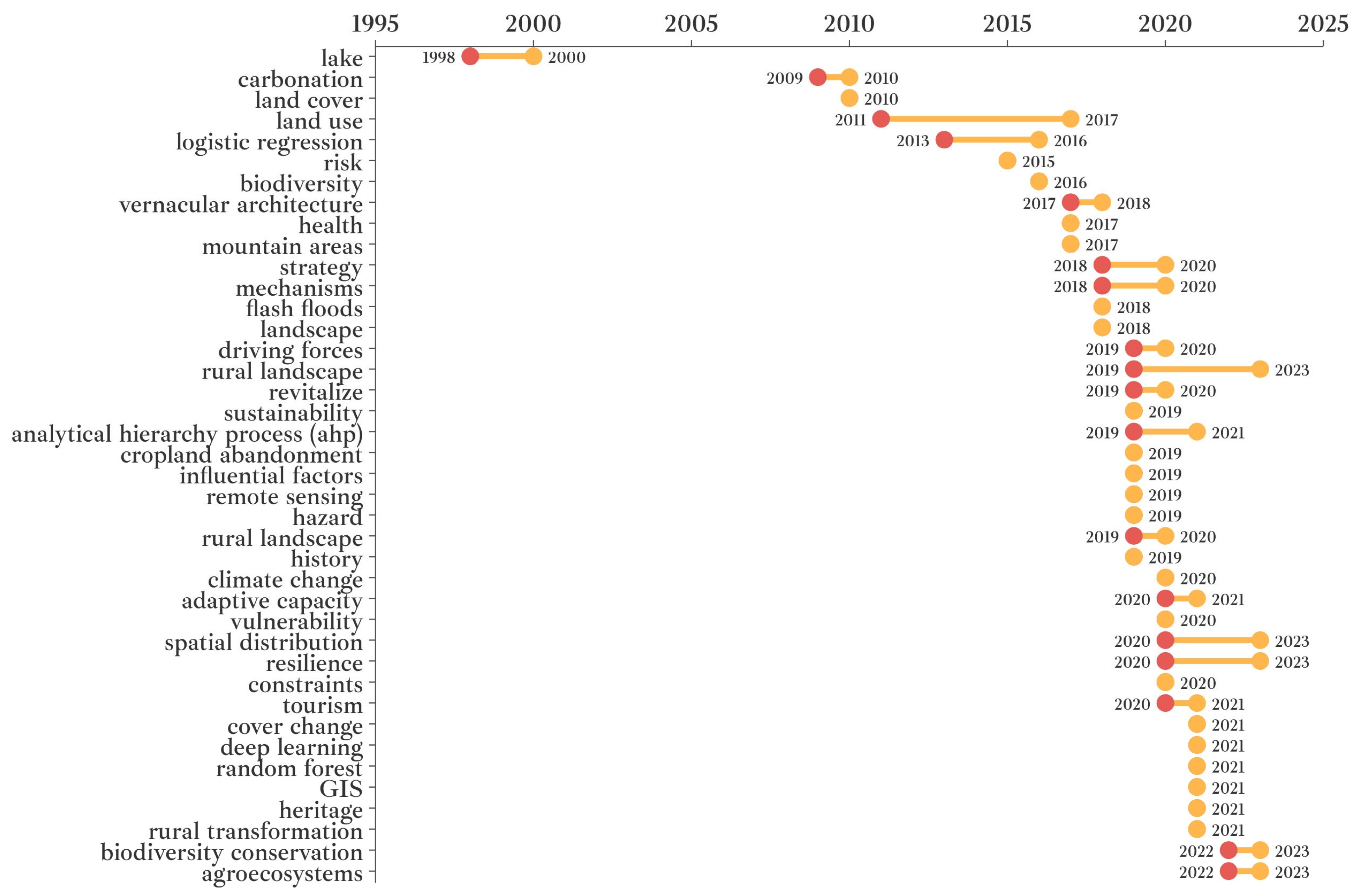
3.5.1. Evolution Analysis of Research Hotspots Based on Keyword Time Zones

Keyword frequency analysis is commonly used in bibliometrics to reveal the distribution of research hotspots. In this study, CiteSpace was employed to analyze the keywords in the RFCMRS literature data, resulting in 668 nodes. Keywords with a frequency of 10 or more, such as “urbanization”, “biodiversity”, and “diversity”, were selected for display, and the generated keyword co-occurrence network can be seen in Figure 14. In the figure, each node represents a keyword, and the size of the node is proportional to the keyword’s frequency. The lines connecting nodes represent the co-occurrence network of keywords, and the weight of the co-occurrence network is determined by how frequently keywords appear together in multiple articles [111]. Based on the co-occurrence frequency of keywords, the significant keywords are “land use” (31 occurrences), “evolution” (29 occurrences), and “conservation” (25 occurrences).
Table 10 shows the 33 main co-occurring keywords that are the most frequent and influential in the RFCMRS field. In addition to core keywords directly reflecting RFCMRS content, such as “land use”, “pattern”, and “urbanization”, other high-frequency and high-centrality keywords like “biodiversity” and “vulnerability” appear frequently. The prevalence of these keywords indicates future trends and hot areas of research in rural cluster landscape studies. In particular, the keyword “climate change” highlights the importance of addressing the impact of climate change factors on mountainous rural settlements in future RFCMRS research.
By analyzing the temporal zoning map of keywords (Figure 15), we found distinct variations in the research hotspots of RFCMRS across different developmental stages.
(1)
In the early stages of RFCMRS (1991 to 2008), the focus was on the ecological evolution of mountainous rural settlements [112] and land use [113]. During this period, keywords such as “diversity” and “conservation” became widely discussed [114]. Researchers aimed to uncover the development mechanisms of mountainous rural settlements within complex geographical environments [112]. Studies during this phase included assessments of land use in mountainous rural settlements [113] and also addressed potential hazards like “erosion” and “debris flow” [115]. During this time, RFCMRS primarily focused on the ecological dimension of the distinctive features of mountainous rural settlements, with no exploration of rural settlement ecosystem services, climate change, and other related topics, signifying the embryonic stage of RFCMRS.
(2)
Between 2009 and 2017, “climate change”, “ecosystem services”, “adaptive capacity”, and “risk” became new research hotspots in RFCMRS. During this period, “climate change” gradually emerged as a popular topic, exploring the long-term impact of extreme weather events on the ecological environment of mountainous rural settlements and initiating the development of climate change adaptation plans [116]. Simultaneously, “adaptive capacity” [94,117] and “risk” [118] received widespread attention, investigating how to enhance the adaptive capacity of mountainous rural settlements in regard to climate change and reduce associated social and economic risks. Researchers also began to focus on the ecosystem services that mountainous rural settlements could provide [119], such as clean drinking water, biodiversity conservation, and soil stability. Based on the influence of global climate change, “GIS” [120] and “benefit distribution” [121] also became part of RFCMRS research, exploring the relationship between mountainous rural settlements and neighboring cities to achieve the sharing of landscape resources and mutual benefits. From 2009 to 2017, RFCMRS research mainly centered on maintaining and developing the distinctive features of mountainous rural settlements within the urbanization process, further exploring the potential impacts of climate change on the living conditions and ecosystems of mountainous rural settlements. The quantity of research literature during this period significantly increased compared to the earlier period, indicating a steady-rise stage in RFCMRS research.
(3)
From 2018 to June 2023, the research hotspots in RFCMRS gradually shifted towards the study of mountainous rural settlements’ landscape and spatial patterns, sustainability, driving forces, and mobility. In this phase, the academic community placed high importance on the social and economic factors of mountainous rural settlements and explored their impact on the landscape and spatial functions of these settlements [122]. Some researchers analyzed the driving factors and mechanisms that influence the landscape characteristics of mountainous rural settlements, such as land use changes [123], population movement and migration [124,125,126], and the development of rural tourism industries [127], among others. Researchers paid particular attention to the impact of urbanization [128] on the landscape patterns of mountainous rural settlements, exploring methods for preserving and revitalizing the cultural and ecological characteristics of these settlements. “Agricultural eco-efficiency” [129] gained increasing attention, and primarily involved studying how to achieve sustainable agricultural development in mountainous rural settlements by improving agricultural ecological efficiency and meeting the needs of local communities to help their livelihoods and economic wellbeing [130]. During this period, there was an explosive growth in the number of publications on RFCMRS, and research on the topic became more interdisciplinary and multidimensional, focusing on the socioeconomic factors, sustainable development, and spatial patterns of rural settlement landscapes, marking a phase of diverse development in RFCMRS.
Overall, the evolution of RFCMRS keywords reflects researchers’ deepening understanding of mountainous rural settlements in the context of rapid urbanization, climate change impacts, ecosystem services, and landscape and spatial patterns. Based on the keyword timeline map, the development of RFCMRS can be divided into the embryonic stage, steady-rise stage, and diverse development stage.

3.5.2. Identification of Research Hotspots Based on Keyword Burst

The keyword burst detection feature in CiteSpace can identify words with high-frequency changes within a certain time period [46]. In the RFCMRS literature from 1991 to 2023 (first six months), a total of 334 burst keywords were detected, and this paper selected the top 30 burst keywords for further analysis. Figure 16 illustrates the keyword bursts in different time periods, and it reveals four main research hotspots in the current RFCMRS.
(1)
Research on Climate Change and its Risks
The burst keywords “climate change”, “adaptive capacity”, “vulnerability”, “risk”, and “influential factors” are all related to climate change and its associated risks in rural settlements, indicating that climate change risks are one of the current research hotspots in RFCMRS. Keywords like “flash floods” and “hazard” and their related literature reflect researchers’ significant attention towards the adaptive capacity of mountainous rural settlements in regard to responding to climate change risks.
(2)
Research on Mountain Ecosystem Conservation and Services
The burst keywords “agroecosystems”, “biodiversity”, “health”, and “cover change” express considerations regarding the interactions between the features and characteristics of mountainous rural settlements and ecosystem services. Additionally, keywords like “spatial distribution” and “cover change” and their related literature reflect the importance of vegetation change and ecological spatial distribution in shaping the features and characteristics of mountainous rural settlements.
(3)
Research on Cultural Heritage and Rural Tourism
From the burst keywords “rural landscape”, “history”, “heritage”, “tourism”, and “rural transformation”, it can be observed that the significance of distinctive elements, such as traditional architecture, natural landscapes, cultural landscapes, intangible cultural heritage, and other features of mountainous rural settlements, in economic development is gradually gaining attention. This has attracted researchers to engage in studies related to cultural heritage preservation and the tourism industry.
(4)
Research on Spatial Structure and Land Use Change
The burst keywords such as “land cover”, “land use”, “revitalize”, “constraints”, and “cropland abandonment” are directly related to land use changes, spatial development, and the industrial revitalization of mountainous rural settlements. Additionally, the related literature concerning “resilience” and “driving forces” primarily involves the study of influencing factors and driving mechanisms in mountainous rural settlements and land use planning methods to enhance their adaptive capacity. Furthermore, keywords like “remote sensing”, “GIS”, “analytical hierarchy process”, “deep learning”, and “random forest” in the related literature pertain to the application of emerging technologies in spatial structure and land use research, contributing to the deepening analysis and evaluation methods for features and characteristics of mountainous rural settlements.
These various burst keywords in RFCMRS form four categories of research hotspots, reflecting the multidimensional understanding and exploration by researchers of elements such as climate change, mountain ecosystems, cultural heritage, spatial structure, and land use in mountainous rural settlements.

3.6. Analysis of RFCMRS Research Trends

In the previous text, we have already conducted an analysis of keyword clustering, keyword time partitioning, and the keyword emergence for RFCMRS based on bibliometric data from 1991 to 2023. The keyword clustering yielded the key issues of RFCMRS; through keyword time partitioning and keyword emergence analysis, the research phases of RFCMRS and recent research hotspots were identified. On this basis, we identify three main research trends within RFCMRS that are expected to develop in parallel.

3.6.1. Research Trend in Risk Response based on Climate Resilience and Ecological Protection

Based on the analysis of Section 3.5, it can be observed that there is a higher occurrence of key terms such as “risk” (2016), “climate change” (2012), “adaptive capacity” (2016), and “resilience” (2020) that emerged after 2012. All of these terms are related to the climate resilience and ecological protection of mountainous rural settlements. With the increasing impact of global climate change, mountainous rural settlements, especially in high-altitude and steep terrain areas, face various risks, such as geological disasters, soil erosion, ecological degradation, landslides, and more. These risks not only threaten the ecological environment of these settlements but also impact the livelihoods and socio-economic development of the residents. Consequently, this will receive further attention from researchers worldwide.
Climate resilience refers to the ability of rural settlements to reduce losses and impacts through their own adaptability when facing the risks posed by climate change, as well as their ability to maintain or restore their normal functions. In recent years, research on the climate resilience of mountainous rural settlements has been increasing. Through a bibliometric analysis of RFCMRS, we have observed a growing body of research in recent years concerning the climate resilience of mountainous rural settlements. Researchers have explored factors influencing climate resilience in these areas, climate risk assessment, and risk management strategies. In terms of climate resilience influencing factors, He, J. et al. found that the primary factors affecting the sustainability of rural settlement ecosystems in the Loess Hilly Plateau of China are temperature, water, and soil quality [131]. Regarding climate risk assessment, Rumbach, A. et al., based on the “MOVE” framework [132], assessed environmental risks in five rapidly developing towns and villages in the Darjeeling region of the Indian state of West Bengal [133]. In the context of risk management strategies, Omerkhil, N. et al. explored the micro-adaptation strategies of rural settlement residents in Afghanistan’s least developed areas (Least Developed Countries, LDCs) in response to climate change risks [97].
Ecological protection research refers to the consideration of the carrying capacity and ecological service functions of the natural environment in the planning, construction, and management of mountainous rural settlements, with the adoption of effective measures to protect the ecosystem, thereby achieving a harmonious coexistence between humans and nature. Zeng, X. et al. analyzed suitable landscape development patterns for mountainous rural settlements from an ecological perspective, and they found that local improvements in the ecological environment would promote the economic income of rural residents and enhance their quality of life [134]. The impact of climate change on the vital components of mountainous landscape ecology is one of the reasons leading to changes in the treeline pattern and biodiversity [24]. In recent years, some researchers have begun to explore the mechanisms and risk mitigation strategies related to the formation of features and characteristics of mountainous rural settlements based on ecological protection objectives. These include aspects such as vegetation cover, water circulation and conservation, biodiversity distribution, mountain landscape ecological structure, and ecological services. In terms of vegetation cover, Bazan, G. et al. used the example of the Sicani Mountains (western−central Sicily) to study the interactions between long-term human settlement catchment areas and vegetation series, discovering a causal relationship between vegetation series and human settlement patterns [135]. In the context of water circulation and water conservation, Liao, W. et al. utilized remote sensing technology, historical analysis, and field investigations to explore the spatial and temporal combination patterns of terraced water management techniques, terraces, and water facilities, as well as the construction characteristics of human living environments in mountainous rural settlements [136]. Regarding biodiversity distribution, Xiang, L. et al. used the example of Qiaotou Town in Chongqing, China, to propose five strategies and models for rural ecological revitalization based on mountainous biodiversity conservation goals [137]. In the domain of mountain landscape ecological structure, Li, G. et al. selected landscape pattern indices to describe the structural spatial differentiation characteristics of Ecological Land in Rural Settlements (ELRS) located in mountainous, hilly, and plain areas of China’s Central Plains region, as well as their response to the natural, social, and economic conditions of rural settlements [138]. In the area of ecological services, Jiang, D. et al. studied the spatiotemporal variations, terrain effects, and spatial correlation characteristics of Ecosystem Service Values (ESV) at the township scale in the Dalou Mountain Area of the Yunnan−Guizhou Plateau in China [139].
The studying of climate resilience and ecological protection in mountainous rural settlements are closely related [140]. By restoring and protecting the ecosystems around these settlements [141] and establishing green infrastructure [142], the climate resilience of rural settlements can be enhanced. Considering the biodiversity, ecosystem service protection, and socio-economic development factors of mountainous rural settlements, deepening the planning, implementation, monitoring, and technical research of ecological restoration helps in establishing an evaluation and monitoring system for their climate resilience. Hence, it is evident that research on risk response based on climate resilience and ecological protection will provide guidance for the positive development of the unique landscape of mountainous rural settlements, aiding in exploring safe and effective development paths and methods [143]. In the study of ecological environmental risks in mountain rural settlements, it is essential to recognize and analyze the regional and environmental differences of these settlements in order to propose targeted measures and methods for protecting and maintaining the mountainous natural environment, ensuring it can continuously benefit future generations. Researchers have already explored this topic. For example, Qin Y. constructed a sustainable development model for rural settlements to analyze the influencing factors of the natural environment and socio-economic levels in the mountainous rural settlements of the Miao Ling mountains in southwestern China [144]. Manhas et al. focused on the impact of climate change on the natural environment of mountain rural settlements in Uttarakhand, India, particularly emphasizing glacier melt and flood risks. They highlighted the importance of coordinated development initiatives, ecological restoration, and protection to lay the foundation for sustainable development [145]. Elbakidze and Angelstam evaluated the role of traditional village systems in sustainable forest management in Ukraine’s Carpathian Mountains, finding that traditional villages, as basic units of the Skole district’s forest landscapes, are crucial for maintaining regional socio-cultural values and biodiversity [146]. Kang et al. found that, to address the environmental protection issues of mountain villages caused by geographical disadvantages, South Korea proposed the Mountain Village Development Support Program. This program improves villagers’ living conditions and promotes agricultural and forestry development by commercializing forest resources, establishing favorable settlement conditions, and expanding government support [147]. Jian, using the example of the Yao mountain rural settlements in northern Thailand, demonstrated how the Royal Hilltribe Development Program positively contributes to the long-term wellbeing of tribal people. He suggested that the focus, direction, methods, and implementation of development strategies must be aligned with local conditions to effectively protect the natural environment of mountain rural settlements [148]. In the future, based on numerous case studies by researchers from various countries, it is important to deepen the study of universal analysis methods and individualized construction strategies for the distinctive features of mountain rural settlements.

3.6.2. Research Trend in Factors of Features and Characteristics based on Regional Culture and Landscape Configurations

Based on the analysis of Section 3.5, it is evident that there is a higher degree of burst keywords such as “landscape” (2007), “vernacular architecture” (2017), “mountain areas” (2018), “rural landscape” (2019), and “revitalize” (2019) that emerged after 2007. All of these keywords are related to the regional culture and landscape patterns of mountainous rural settlements. The distinctive scenic elements of mountainous rural settlements encompass not only landscape features that coexist harmoniously with nature but also architectural features closely linked to regional culture. This distinctive scenery has gradually developed over long-term human−nature interactions, reflecting people’s reverence for nature, attachment to the land, and the preservation of traditional culture.
Regional culture serves as the foundational condition for the formation of features and characteristics of mountainous rural settlements and is primarily characterized by spatial forms and architectural aesthetics. Each rural settlement possesses a unique historical background, ethnic customs, and religious beliefs. Over an extended period of development, these cultural elements interact with geographical features, climate, ecology, building materials, and other settlement material forms, collectively shaping distinctive architectural languages and styles. The interaction between regional culture and the natural environment not only determines the spatial layout and hierarchical structure of mountainous rural settlements but also influences elements such as the forms, materials, and colors of their public and residential buildings. These factors together form the core of the unique characteristics of mountainous rural settlements. Researchers have undertaken studies regarding various aspects, including the identification and quantification of regional cultural elements in mountainous rural settlements, spatial representation forms, and architectural representation forms. In terms of identifying and quantifying regional cultural elements, Xie, W. studied the regional and ethnic cultural elements of the Qiang ethnic group in the Aba Prefecture, Sichuan Province, China. The study involved the analysis of their residential systems and environment, encompassing the conceptualization of housing, scene composition analysis, and the components of fixed, semi-fixed, and movable elements in compositional cultural landscapes [149]. Concerning spatial representation of regional cultural elements, Yao, M.Y. et al. utilized a method for characterizing 3D landscape indices to analyze the spatial composition pattern of “Mountain−Forest−House-Water−Forest” centered around human-made elements that emerged in Chengkan Village, Anhui Province, China [150]. Lastly, in terms of architectural representation of regional cultural elements, Zhao, X. explored the regional cultural representation forms of six types of karst rural settlements in the Guizhou province, China, in terms of settlement size, layout, environment, architecture, and living customs. [151].
Landscape patterns serve as the spatial carriers for the formation of features and characteristics of mountainous rural settlements. Various elements, such as spatial structures, transportation networks, public spaces, and green systems, are interrelated with the mountainous terrain, climate, and vegetation, collectively constituting the landscape patterns of mountainous rural settlements. Houses in these settlements are often distributed along ridges or river valleys, resulting in a terraced layout, creating a unique linear or clustered spatial pattern. Researchers have conducted studies on various aspects of mountainous rural settlements, including landscape elements, three-dimensional landscapes, landscape functions, landscape genes, cultural landscapes, and agricultural landscapes. Regarding landscape elements, Chen, Z. et al. used the SBE and SD methods to analyze the types and contributions of landscape elements in the farmland landscape of low hills and hillocks [152]. In terms of three-dimensional landscapes, Shi, L. et al. deconstructed the landscape three-dimensional structure and ecological element composition of Tibetan mountainous rural settlements in the Gansu province from multiple perspectives [153]. Concerning landscape functions, Cao, Y. et al. used clustering methods and niche models to analyze the landscape and spatial functions of five types of rural settlements, as well as the suitability of land use [154]. Regarding landscape genes, Wang, Z. et al. explored the spatial reconstruction of tourism-oriented mountainous rural settlements, such as Chongmudang Village in the Hunan province, and found that landscape genes composed the primary content of the spatial reconstruction of this rural settlement [155]. In the context of cultural landscapes, Zou, C. et al. employed the Landscape Gene Information Chain Theory to assess and analyze the landscape structure and potential cultural characteristics of Xiami Village in the Fujian province, China [156].
Mountain rural settlements are limited by geographical conditions, resulting in scarce arable land resources, which are unfavorable for traditional agricultural development. However, these areas possess unique landscape patterns and architectural features with high potential for tourism development. Through scientific and rational planning and development, not only can the local cultural characteristics be preserved and promoted, but the local economy can also be boosted, residents’ living standards can be improved, and coordinated development of the economy, culture, and ecology can be achieved. According to the World Tourism Organization, mountain tourism accounts for about 20% of global tourism, playing a significant role in the development of the global tourism industry [157].
Sustainable mountain tourism can bring extensive economic benefits to rural settlements [158]. Mountain tourism has the potential to generate higher income, especially adventure tourism, which attracts tourists willing to pay a premium [159]. Mountain rural tourism can serve as an alternative to mining activities, enhancing local ecology, as seen in Jiufen, Taiwan [160], and the Kopaonik mountains in Italy [161]. These areas, with their high levels of natural features, have brought economic benefits to local communities. Gajić et al. found that mountain rural settlements in Serbia could establish a barrier against COVID-19 by developing tourism [162]. However, due to the limited capacity of mountain ecosystems, excessive economic activities such as mountain tourism are subject to government regulation and restrictions [163]. To address this challenge, scholars have proposed various adaptive strategies. For example, Thimm et al. suggested implementing hiking as an adaptive strategy to replace snow tourism in Germany [164]. Kortoci et al. used the Valbona Valley National Park in Albania as an example, finding that mountain tourism in rural areas can promote the protection of natural, social, and cultural environments [165].
In conclusion, research on settlement elements based on regional culture and landscape patterns will provide a crucial theoretical and practical foundation for the preservation and revitalization of features and characteristics of mountainous rural settlements in the future.

3.6.3. Research Trend in Human Settlements Based on Sustainable Development Goals

Based on the analysis of Section 3.5, it can be observed that there is a higher degree of burst keywords such as “sustainability” (2019), “biodiversity” (2003), “influential factors” (2019), and “health” (2017) that emerged after 2003. All of these keywords are related to the research on the sustainable development of the living environment in mountainous rural settlements. Based on the analysis of the literature related to these keywords, it is evident that researchers are emphasizing the study of living environments based on low-carbon goals and sustainable development, thereby generating the third significant research trend for future RFCMRS. In the face of the challenges posed by global climate change, the construction of low-carbon and sustainable living environments has become a current research hotspot. The idea of “Sustainable Development Goals” originates from the United Nations Sustainable Development Goals (SDGs) [166]. “Low-Carbon Development” is highly associated with several of the SDGs, including “Goal 7: Clean Energy”, “Goal 11: Sustainable Cities and Communities”, “Goal 12: Responsible Consumption and Production”, “Goal 13: Climate Action”, “Goal 15: Life on Land”, and “Goal 17: Partnerships”. Therefore, this paper considers “low-carbon development” to be an important approach to achieving sustainable development goals for mountainous rural settlements, and the achievement of sustainable development goals also promotes the advancement of low carbon technologies and strategies. The geographical location and climate conditions of mountainous rural settlements have unique characteristics, making it crucial to achieve low-carbon and sustainable living environment development.
The architectural style, material choices, and construction techniques in mountainous rural settlements are closely related to their geographical environments, climatic conditions, and cultural backgrounds. With the acceleration of modernization, the use of modern building materials and energy technologies has not only eroded the traditional appearance of mountainous rural settlements but has also increased carbon emissions and ecological pollution in mountainous regions. Balancing the preservation and inheritance of traditional culture with the adoption of low-carbon and sustainable building technologies and materials has become a key focus in the research on the preservation of features and characteristics of mountainous rural settlements. Researchers have conducted studies on various aspects of mountainous rural settlements, including low-carbon practices, carbon emissions, building materials, renewable energy, and ecological productivity. Concerning low-carbon practices and carbon emissions, Ge, J. et al. conducted a case study on carbon emissions in villages from four different geomorphic types (mountainous, hilly, plain, and island) and eight different industry types in the Yangtze River Delta region, China. They developed a method for assessing village-level carbon emissions [167]. In terms of building materials, Kari, N. et al. surveyed the architectural heritage of rural settlements in the Tlemcen Mountains in northwestern Algeria, identifying and recording data related to history, geography, architectural spaces, building functions, construction methods, and building materials [168]. Regarding renewable energy, Kumar, A. et al. proposed a two-layer framework based on decision and optimization tools to design a sustainable micro-grid for hilly rural settlements, incorporating solar and hydropower along with backup diesel generators [169]. In the context of ecological productivity, Choi, S.I. et al. proposed construction measures for mountainous ecological rural settlements, focusing on aspects such as agricultural and forestry production, forest management, and urban−rural experience projects [170].
Secondly, the geographic location, road transportation, municipal pipelines, water environment, and waste collection and treatment infrastructure of mountain rural settlements are also closely related to low-carbon and sustainable development goals, and scholars have already conducted relevant research on these topics. Concerning geographical location, Yu, Z. et al. found that the slope, water systems, and roads significantly impact rural settlements in the Fujian province, with 80% of these settlements being located in areas with a slope less than 10 degrees, over 67% being within 2 km of rivers or lakes, and 98.28% being within 500 m of roads [171]. Regarding road transportation, Yang, R., discovered that spatial direction and transportation accessibility had the greatest impact on the spatial distribution of rural settlements in the Guangdong province, China, often resulting in settlements situated near river valleys and following transportation routes [82]. In the context of municipal utilities, Fang, S. et al. studied the design of sewage pipelines for rural settlements in the low-lying polder areas and hilly areas of Yixing City, China [172]. Concerning water environments, Shi, Q. et al. explored the water environment adaptability of traditional rural settlements in the southeastern Jinzhong region of China, summarizing it as a macro framework of a “two-level circulation subsystem” with characteristics of “multiple functions using a single element” [173]. In the area of waste collection and treatment, Ding, K. et al. suggested landscape planning and design to address the imbalances in complex ecosystems in hilly rural settlements [174].
In conclusion, research on residential environments based on low-carbon and sustainable development goals can be closely related to the ecological, production, and living spaces of mountainous rural settlements. It will significantly influence the development mechanisms and representation forms of features and characteristics of mountainous rural settlements, making it a prominent research focus in future RFCMRS.

4. Discussion

Based on the analysis conclusions of the literature distribution characteristics, co-citation features, key issues, research hotspots, and trends related to RFCMRS, this paper suggests that researchers from diverse professional backgrounds in the field of RFCMRS prioritize research on the following three categories of RFCMRS issues in the future.

4.1. Improving the Evaluation System for Features and Characteristics of Mountainous Rural Settlements

The composition of features and characteristics of mountainous rural settlements exhibits strong uniqueness. From the perspective of human settlement studies, factors such as topographic variation, variable climate, strong ecological sensitivity, unique natural landscapes, diverse regional and ethnic cultures, and more complex construction techniques in mountainous areas have led to a special dependency between people and settlement environments. Based on the cognitive understanding of architectural spatial form, the logical composition of features and characteristics of mountainous rural settlements can be seen as a tripartite connection of settlement, architecture, and landscape. With the acceleration of urbanization, the characteristics of population aggregation, scarce available land, limited resources, and unchanged transportation in mountainous rural settlements will deepen the contradiction between environment and development. This phenomenon may lead to natural disasters and engineering disasters, such as ecological imbalance, environmental deterioration, drastic reduction in biodiversity, and soil erosion in mountainous regions, as well as the severe loss of cultural heritage, including regional and ethnic cultures, traditional settlement forms, and local construction techniques. Currently, international organizations, such as the International Council on Monuments and Sites (ICOMOS International) and the International Centre for the Study of the Preservation and Restoration of Cultural Property (ICCROM), have released reports related to the preservation and reconstruction of rural landscapes. Examples include “Analysis of Case Studies in Recovery and Reconstruction” (2021) [175] and the “ICOMOS Guidance on Post-Trauma Recovery and Reconstruction for World Heritage Cultural Properties document” (2017) [176].
In order to effectively preserve and rejuvenate the features and characteristics of mountainous rural settlements, it is imperative to establish a multidimensional, multilevel comprehensive evaluation system encompassing elements such as ecological environments, land use, spatial morphology, architectural styles, public aesthetics, and industrial development. Before 1990, the evaluation of features and characteristics of mountainous rural settlements was often based on subjective judgments of the public’s aesthetics and preferences, establishing a village settlement landscape evaluation index system [177]. Between 1990 and 2010, researchers began to separately conduct evaluations of village settlement landscape features and architectural features. In the evaluation of village settlement landscape features, researchers established an evaluation system for village settlement landscape features by comparing their influencing factors and evolution over time [178]. In terms of village settlement architectural features, researchers mainly used economic, statistical, and sociological methods, adopting a regional cross-comparison approach to identify the influencing factors of features and characteristics of mountainous rural settlements, and thus established an evaluation index system [179]. From 2010 to the present, humanism has gradually become an important perspective in terms of the features and characteristics of mountainous rural settlements [180], and resident perception is considered to be a subjective feedback on natural and ecological environments and settlement form aesthetics, being central to the planning of features and characteristics of mountainous rural settlements. This has led to research outcomes such as the Landscape Preference Spatial Framework (LPSF) for village settlements [181,182] and visual landscape distribution maps [183], which draw complex images of mountainous rural settlements from the perspective of evaluating environmental observers. Additionally, there are many active evaluation systems and methods that have been practically tested and developed on national and regional scales in response to specific environmental, cultural, and economic developments. Examples include the New Zealand Landscape Character Assessment System used for landscape classification and identification [184], the Visual Quality Assessment Tool for evaluating the diversity of rural landscapes [185], and the Vulnerability Assessment System for rural settlements in hilly areas [186].
The features and characteristics of mountainous rural settlements evaluation system should include the following five parts: feature information collection, influencing factor identification, influencing factor weight analysis, database construction, and evaluation computation criteria and methods. Currently, relatively mature and authoritative landscape evaluation systems include the Visual Resource Management (VRM) system of the United States Bureau of Land Management [187], the Visual Management System (VMS) of the United States Forest Service [188], and the Scenery Management System (SMS) based on VMS [189]. However, the above evaluation systems have the drawbacks of lacking comprehensive and quantitative evaluation elements for landscape and architectural features, and they lack elements such as aesthetic and public participation. This leads to issues such as a single perspective and strong subjectivity in the evaluation results. To address the above issues, some scholars have decomposed the evaluation goals of rural human settlements from the perspective of human settlement science and decomposed them into a four-level evaluation system. In the four-level evaluation system, the subjective sensibility is expanded to include a comprehensive measure that incorporates village social and economic structure, environmental sanitation quality, and social development vitality. The objective spatial description is extended from topography to landforms and landforms, and a quantitative evaluation is conducted on objective spatial scale, spatial hierarchy, landscape pattern, and other indicators using GIS technology [190]. In future research on the features and characteristics of mountainous rural settlements evaluation system, researchers can try to comprehensively apply “3S” technology, AI, big data, deep learning, and other technologies to form a three-dimensional cognitive model of the ecological environment, settlement form, human perception [190], and a fuzzy mathematical model [191]. These approaches can establish a comprehensive features and characteristics of mountainous rural settlements database to achieve a fuzzy, visual, and quantitative evaluation of features and characteristics of mountainous rural settlements.

4.2. Deepening the Study on Evolutionary Phenomenon and Mechanism for Features and Characteristics of Mountainous Rural Settlements

Compared to flatland areas, the ecological environment and human−environment interactions in mountainous rural settlements are more complex. In recent years, the research scope of RFCMRS has expanded to include the natural landscapes, spatial structures, cultural landscapes, neighborhood forms, and architectural styles of mountainous rural settlements. The research focus has shifted from static synchronous studies to dynamic investigations of evolutionary phenomena and mechanisms.
Firstly, the study of the evolutionary phenomena of features and characteristics of mountainous rural settlements can be approached from the perspectives of rural socio-economic structure, environmental sanitation quality, and social development vitality. This broadens the descriptive paradigm from landforms, landscapes, and buildings to climate risks, ecological risks, infrastructure, economic development, and cultural heritage. In the future, RFCMRS researchers can use diverse disciplinary backgrounds and research methods to study the evolution from different dimensions, including socio-economic, natural ecology, regional culture, architectural style, and more. For instance, they can analyze the co-evolutionary patterns between the features and characteristics of mountainous rural settlements and the natural environment from the viewpoints of vertical ecological landscapes, land use, transportation accessibility, agricultural landscapes, and ecological vulnerability. They can also investigate the evolution of architectural styles in mountainous rural settlements through architectural forms, spatial layouts, three-dimensional structures, building materials, structural systems, and residential decorations. Additionally, researchers can explore the evolution of regional culture in mountainous rural settlements by examining religious customs, daily traditions, and ethnic cultures. Analyzing the evolution of landscape patterns in mountainous rural settlements using the “Drivers−Pressures−State−Impact−Responses” (DPSIR) model [192] is another approach.
Secondly, the study of the evolutionary mechanisms of features and characteristics of mountainous rural settlements is the basis for understanding the complex driving relationships among various factors influenced by human activities. In the research of evolutionary mechanisms, it is essential to combine results from diachronic and synchronic analyses, compare the evolution of features and characteristics of mountainous rural settlements in the same area, and explore the spread and impact of these features in neighboring areas. In the future, it should be possible to analyze how the results of evolution from different dimensions, such as socio-economic, natural ecology, regional culture, and architectural style, form the small-world network of production and life in mountainous rural settlements [193]. Based on this analysis, researchers can investigate the hierarchy, scale, relationships, and weights of different dimensions of evolution within this small-world network. This helps determine the overall evolutionary mechanisms of features and characteristics of mountainous rural settlements and establish corresponding dynamic monitoring models and evolutionary analysis models.

4.3. Exploring the Design Methods for Features and Characteristics of Mountainous Rural Settlements Based on the Concept of Sustainable Development

Brown, L.R. (1981) first proposed the three major pathways for achieving sustainable development, which include controlling population growth, protecting the ecological environment, and developing renewable energy sources [194]. The World Commission on Environment and Development (WCED) (1987) provided the first precise and rigorous definition of “sustainable development” in the report “Our Common Future” and established a practical agenda for sustainable development in “Agenda 21” (1992). In 2015, all member states of the United Nations proposed “The 2030 Agenda for Sustainable Development”, which encompasses 17 Sustainable Development Goals (SDGs) [166]. In 2020, the European Observation Network for Territorial Development and Cohesion (ESPON) published an analytical report entitled “European Shrinking Rural Areas: Challenges, Actions and Perspectives for Territorial Governance (ESCAPE)” that explores the socio-economic historical transformations in European rural areas. It proposes the design, implementation, and financing of place-based integrated strategies for rural areas experiencing population decline and economic downturn [195]. Currently, there are over a hundred different definitions of “sustainable development” worldwide, with international organizations and researchers generally defining it from various dimensions, including nature, society, economics, technology, and ethics. Among these definitions, the perspectives related to features and characteristics of mountainous rural settlements mainly include economic sustainability, social sustainability, and environmental sustainability. In their theoretical and design research, these perspectives have organically integrated the core ideas of modern anthropocentrism [196] and ecocentrism [197].
Based on two perspectives, modern anthropocentrism and ecocentrism, the focus of features and characteristics of mountainous rural settlements design research based on the concept of sustainable development can be categorized into two relationship types: “human−human” and “human−nature”. Firstly, the “human−human” relationship perspective primarily explores the spatiotemporal coupling, rational control, and benefit criteria of human activities, as well as ethical and moral norms in human relationships. Research contents in this category mainly include the analysis and representation of regional culture and ethnic culture in mountainous rural settlements, research on the preservation and renewal of traditional settlement spatial forms, research on the three-dimensional layout, spatial organization, architectural styles and forms, and new local building materials (such as ecological concrete and recycled wood) in settlement buildings, among others. Secondly, the “human−nature” relationship perspective primarily starts from the dynamic evolution of the relationship between humans and nature, as well as human control over and alteration of the environment. Research contents in this category mainly involve topography, ecosystems, natural landscapes, low-carbon technologies, renewable energy sources in mountainous rural settlements, and more.
In the future, it is recommended that RFCMRS researchers focus on the comprehensive use of traditional 3S technology, AI, deep learning, big data, CIM (City Information Model), the Internet of Things, and other intelligent technologies and platforms to provide new ideas and methods for the planning and architectural design of features and characteristics of mountainous rural settlements. For example, the use of 3S technology can collect and visualize vast geographic, climatic, and ecological data in mountainous areas. AI technology can provide recommendations for site selection, layout, greening, house structures, and construction materials for mountainous rural settlements. The CIM platform can assist in the planning, construction, and management of various elements of features and characteristics of mountainous rural settlements. Deep learning technology can analyze the cultural symbols and life elements of mountainous rural settlements to help designers quickly understand the traditional culture and lifestyle of these settlements.

5. Conclusions

To understand the current status and research issues of RFCMRS, identify future research trends, and propose future research suggestions, this paper follows a logical progression of “clarifying literature features”, “analyzing keyword clusters”, “extracting key issues”, “dividing research stages”, “discovering research hotspots and trends”, and “proposing future research suggestions”. This paper conducts a knowledge mapping analysis of 865 RFCMRS publications from 1991 to June 2023, as found in the WOS database. It systematically investigates the literature distribution, co-citations, research collaborations, key issues, research hotspots, and trends within RFCMRS and resulting corresponding research findings.
In terms of the literature features of RFCMRS, the paper found that the RFCMRS literature overall exhibits continuous growth, interdisciplinary participation, and international collaboration. Three research conclusions were drawn. Firstly, researchers from China and Syria published the first RFCMRS literature in 1991, and the annual output has been increasing. RFCMRS involves various disciplines, with journals in the fields of environment, geography, and geology publishing a significant amount of literature directly related to the geographical characteristics of mountainous rural settlements. China, the United States, Italy, India, and Japan are the top five countries in terms of RFCMRS literature output. Secondly, the top 20 highly cited pieces of RFCMRS literature focus on spatial distribution and patterns, rural revitalization, urbanization processes, mountain and hillside environments, and sustainable development. This indicates that the mountain conditions, spatial patterns, land use, and development policies of mountainous rural settlements are crucial research topics in RFCMRS. Finally, in terms of collaboration, most researchers prefer to conduct studies individually or in small groups, with frequent national-level collaborations in countries with high literature output, such as China and Italy. The United States holds a central position in the RFCMRS cooperation network, having established close collaborations with other countries and high citation rates.
Regarding key issues, research trends, and research suggestions for RFCMRS, four research conclusions were drawn. Firstly, based on keyword clustering analysis, RFCMRS has 10 main research clusters, which were further categorized into the following three key issues: “Climate Change Risks and Adaptation Issues”, “Regional Cultural Heritage and Economic Development Issues”, and “Ecological Environment Protection and Harmonious Coexistence Issues”. Secondly, through CiteSpace’s keyword time-zone and keyword burst analysis, the paper identified the research hotspots of RFCMRS. The evolution of RFCMRS research hotspots was divided into three stages: budding, steady rise, and diverse development. The early research mainly focused on the ecological evolution and land use of mountainous rural settlements; after 2009, climate change, ecosystem services, adaptive capacity, and risk became new hotspots; from 2018 to the present, research hotspots gradually shifted towards the landscape pattern, spatial pattern, sustainability, and mobility of mountainous rural settlements. Thirdly, the analysis of research clusters, key issues, and research hotspots indicated the following three research trends for RFCMRS: “Research Trends in Risk Response Based on Climate Resilience and Ecological Protection”, “Research Trends in Morphological Elements Based on Regional Culture and Landscape Pattern”, and “Research Trends in Human Settlement Environment Based on Low-Carbon Goals and Sustainable Development”. Finally, based on the comprehensive judgment of bibliometric analysis results and existing policies in various countries, the paper suggests that researchers prioritize the following three topics for future research: “Improving the Evaluation System of Mountainous Rural Settlements’ Characteristic Features”, “Deepening the Study of Evolution Phenomena and Mechanisms of Mountainous Rural Settlements’ Characteristic Features”, and “Exploring Mountainous Rural Settlements’ Characteristic Features Design Methods Based on Sustainable Development Principles”.
The research findings of this paper are of clear importance in regard to RFCMRS. Due to the significant absolute altitude and relative height difference of mountainous areas [3], their sensitivity to climate change is second only to the polar regions [3,4]. Affected by climate change, the ecological, environmental, resource, and socio-economic development effects of features and characteristics of mountainous rural settlements are continuously strengthening. The future development of RFCMRS will inevitably have a broad and profound impact on global human settlement construction. This paper, based on the bibliometric research method of CiteSpace, explores the literature distribution characteristics, research clusters, key issues, research hotspots, and trends of the characteristic appearance of mountainous rural settlements. It helps researchers in architecture, urban planning, landscape gardening, and other fields to quickly understand the developmental context and research trends of RFCMRS. The analysis of changes in RFCMRS publication volume, collaborators, and citation situations displays the main researchers, disciplinary scope, and global cooperation network of the study. By analyzing the high-frequency keywords and research clusters of RFCMRS, key issues are summarized, reflecting the current progress of the research. Based on the analysis of burst keywords in RFCMRS, the recent research hotspots are identified, the main development trends are judged, and future research suggestions for researchers are proposed. The literature data selected in this paper cover both the theoretical research and practical methods of RFCMRS. Therefore, the conclusions drawn are beneficial not only in enriching the theoretical framework of the characteristic appearance of mountainous rural settlements but also in providing useful references for their construction strategies and design method research. The bibliometric method used in this paper effectively identifies, classifies, summarizes, and visualizes a vast amount of literature data, providing quantitative conclusions and qualitatively judging the key issues and development trends of the study. With the continuous development of RFCMRS in the future, researchers should, based on the latest literature data, research findings, and development policies at that time, conduct bibliometric analyses and research again to address the newly emerging complex challenges.
However, this paper has certain limitations in regard to data and research methods. The bibliometric analysis of the RFCMRS literature in this paper is based solely on data retrieved from the WOS database without comparative analysis of literature data obtained from other well-known databases (such as MDPI, Scopus, ScienceDirect) under the same search criteria. The bibliometric data in this article do not encompass books, government reports, and informal publications, all of which could potentially affect the conclusions drawn from the publication volume and collaboration analysis within the RFCMRS literature. This paper mainly relies on burst keywords and their related literature data analysis, and it is supplemented by subjective judgments to identify RFCMRS research hotspots and trends. However, existing bibliometric analysis software finds it challenging to determine whether current RFCMRS research hotspots will persist in the future, so the analysis does not provide the duration of the three research trends. To address this issue, future efforts should expand the types of literature information included in databases, such as WOS, and simultaneously update and improve the analysis functions of bibliometric software such as CiteSpace. Researchers are encouraged to strengthen consideration of the above limitations in subsequent studies, providing a more comprehensive understanding of the complexity and diversity of mountainous rural settlement characteristics and assisting in the continued deepening of RFCMRS.

Author Contributions

Conceptualization and funding acquisition, E.Y.; writing and methodology, Q.Y.; data curation and visualization, N.A., B.L. and Y.L. All authors have read and agreed to the published version of the manuscript.

Funding

This research was funded by the National Social Science Fund of China, Western Project, grant number 23XSH002; The Humanities and Social Science Foundation for the Ministry of Education, Youth Project, China, grant number 23YJCZH275; Social Science Foundation of Chongqing, China, grant number 22SKGH431.

Institutional Review Board Statement

Not applicable.

Informed Consent Statement

Not applicable.

Data Availability Statement

Publicly available datasets were analyzed in this study. These data can be found on Web of Science.

Conflicts of Interest

The authors declare that they have no known competing financial interests or personal relationships that could have appeared to influence the work reported in this paper.

Nomenclature

Agr Ecosyst EnvironAgriculture Ecosystems and Environment
Appl GeogrApplied Geography
CCAClimate Change Adaptation
DPSIRDrivers-Pressures-State-Impact-Responses
Ecol IndicEcological Indicators
Eng GeolEngineering Geology
FAOFood and Agriculture Organization of the United Nations
GECGlobal Environmental Change
Habitat IntHabitat International
ICCROMInternational Centre for the Study of the Preservation and Restoration of Cultural Proper
ICOMOS InternationalInternational Council on Monuments and Sites
J Environ ManageJournal of Environmental Management
J Geogr SciJournal of Geographical Sciences
J Mt Sci-EnglJournal of Mountain Science
J Rural StudJournal of Rural Studies
LNTSLandscape Network of Traditional Settlements
MMAMarginal Mountainous Areas
Nat HazardsNatural Hazards
PESPayment for Ecosystem Services
P Natl Acad Sci USAProceedings of The National Academy of Sciences of The United States of America
RFCMRSResearch of Features and Characteristics of Mountainous Rural Settlements
SMSScenery Management System
VMSVisual Management System
VRMVisual Resource Management
Sci Total EnvironScience of the Total Environment

References

  1. FAO. The State of Food and Agriculture 2001; Food & Agriculture Organization: Rome, Italy, 2001. [Google Scholar]
  2. Seitzinger, S.P.; Gaffney, O.; Brasseur, G.; Broadgate, W.; Ciais, P.; Claussen, M.; Erisman, J.W.; Kiefer, T.; Lancelot, C.; Monks, P.S.; et al. International Geosphere–Biosphere Programme and Earth System Science: Three Decades of Co-Evolution. Anthropocene 2015, 12, 3–16. [Google Scholar] [CrossRef]
  3. International Human Dimensions Programme on Global Environmental Change|PreventionWeb. Available online: https://www.preventionweb.net/organization/international-human-dimensions-programme-global-environmental-change (accessed on 13 October 2023).
  4. Cihlar, J.; Grabs, W.; Landwehr, J. Global Terrestrial Observing System Establishment of a Global Hydrological Observation Network for Climate. In Report of the GCOS/GTOS/HWRP Expert Meeting; WMO: Geisenheim, Germany, 2000. [Google Scholar]
  5. Goss-Durant, G. The MRI in Context: Growth of Mountain Research Beyond Borders & Disciplines. Available online: https://www.mountainresearchinitiative.org/who-we-are/history/103-uncategorized/2827-our-history-the-mountain-research-initiative (accessed on 13 October 2023).
  6. Lauer, W. Human Development and Environment in the Andes: A Geoecological Overview. Mt. Res. Dev. 1993, 157–166. [Google Scholar] [CrossRef]
  7. Körner, C. The Use of ‘Altitude’ in Ecological Research. Trends Ecol. Evol. 2007, 22, 569–574. [Google Scholar] [CrossRef]
  8. Doxiadēs, K.A. Ekistics: An Introduction to the Science of Human Settlements, 1st ed.; Hutchinson: London, UK, 1968; ISBN 978-0-09-080300-2. [Google Scholar]
  9. Yao, Q. Study on Characteristics and Evolutionary Pattern of Architectural Complexity System Based on Architectural Meme Theory. Ph.D. Thesis, Chongqing University, Chongqing, China, 2019. [Google Scholar]
  10. Meybeck, M.; Green, P.; Vörösmarty, C. A New Typology for Mountains and Other Relief Classes. Mt. Res. Dev. 2001, 21, 34–45. [Google Scholar] [CrossRef]
  11. Yao, Q.; An, N.; Gu, G.; Yang, E.; Yang, H.; Li, C.; Yan, K. Research Progress on Features and Characteristics of Rural Settlements: Literature Distribution, Key Issues, and Development Trends. Buildings 2023, 13, 2457. [Google Scholar] [CrossRef]
  12. Chen, Q.; Li, M.; Li, Y.; Li, S. Progress of Mountain Rural Landscapes Research. J. Chongqing Norm. Univ. (Nat. Sci.) 2019, 36, 119–128. [Google Scholar]
  13. Jin, Q. Geography of Rural Settlements in China; Phoenix Science Press: Nanjing, China, 1989; ISBN 978-7-5345-0609-3. [Google Scholar]
  14. Qin, Y.; Luo, G.; Li, Y.; Tan, Q.; Zheng, C.; Yu, M.; Liao, J.; Li, M. Assessment of Sustainable Development of Rural Settlements in Mountainous Areas: A Case Study of the Miaoling Mountains in Southwestern China. Land 2022, 11, 1666. [Google Scholar] [CrossRef]
  15. ICOMOS. ICOMOS-IFLA Principles Concerning Rural Landscapes as Heritage; ICOMOS: Paris, France, 2017. [Google Scholar]
  16. Wu, L. Introdution to Sciences of Human Settlements; China Construction Industry Press: Beijing, China, 2001; ISBN 978-7-112-04506-8. [Google Scholar]
  17. Zhao, W. An Introduction to Studies on Science of Mountain Human Settlements. J. Hum. Settl. West China 2013, 10–19. [Google Scholar] [CrossRef]
  18. Li, B.; Wang, J.; Jin, Y. Spatial Distribution Characteristics of Traditional Villages and Influence Factors Thereof in Hilly and Gully Areas of Northern Shaanxi. Sustainability 2022, 14, 15327. [Google Scholar] [CrossRef]
  19. Li, T.; Li, C.; Zhang, R.; Cong, Z.; Mao, Y. Spatial Heterogeneity and Influence Factors of Traditional Villages in the Wuling Mountain Area, Hunan Province, China Based on Multiscale Geographically Weighted Regression. Buildings 2023, 13, 294. [Google Scholar] [CrossRef]
  20. Işler, B. Early Byzantine Settlements and Rural House Architecture in Central Lycia. ADALyA 2013, 16, 285–304. [Google Scholar]
  21. Juan, X.; Liu, J.P. The Regeneration and Sustainability Development Study on Traditional Residential Building in Qinba Mountain Regions. Adv. Mater. Res. 2011, 224, 89–93. [Google Scholar] [CrossRef]
  22. Su, Y.; Deng, W.; Zhang, J.; Paudel Khatiwada, S.; Koirala, H.L. Livelihood and Land Use Pattern of Melamchi Basin in the Mountainous Areas of Central Development Region in Nepal. In Land Cover Change and Its Eco-Environmental Responses in Nepal; Li, A., Deng, W., Zhao, W., Eds.; Springer Geography; Springer: Singapore, 2017; pp. 307–325. ISBN 978-981-10-2889-2. [Google Scholar]
  23. Wu, L. Brief Discussion on the Development of the Sciences of Human Settlements in Mountain Area: For the 3rd International Symposium on Sciences of Human Settlements in Mountain Area. J. Mt. Sci. 2012, 30, 385–387. [Google Scholar] [CrossRef]
  24. Wang, G.; Liu, G.; Shen, Z.; Wang, W. Research progress and future perspectives on the landscape ecology of mountainous areas. Acta Ecol. Sin. 2017, 37, 3967–3981. [Google Scholar]
  25. Xie, H.; Liu, L.; Li, L. Preliminary Study on the Correlative Problem of the Rural Landscape Planning. Chin. Landsc. Archit. 2003, 39–41. [Google Scholar]
  26. Xie, H. Preliminary researches on the functional evaluation of rural landscape. Acta Ecol. Sin. 2004, 1988–1993. [Google Scholar]
  27. Yu, M.; Li, Y.; Luo, G.; Yu, L.; Chen, M. Agroecosystem Composition and Landscape Ecological Risk Evolution of Rice Terraces in the Southern Mountains, China. Ecol. Indic. 2022, 145, 109625. [Google Scholar] [CrossRef]
  28. Liu, L.; Chen, M.; Luo, P.; Hu, M.; Duan, W.; Elbeltagi, A. A Novel Integrated Spatiotemporal-Variable Model of Landscape Changes in Traditional Villages in the Jinshaan Gorge, Yellow River Basin. Land 2023, 12, 1666. [Google Scholar] [CrossRef]
  29. Long, K.; Wang, N.; Lin, Z. Assessing Scenic Beauty of Hilly and Mountain Villages: An Approach Based on Landscape Indicators. Ecol. Indic. 2023, 154, 110538. [Google Scholar] [CrossRef]
  30. Lakovic, I.; Pekovic, S.; Statuto, D.; Picuno, P. The Katuns-Rural Buildings as a Perspective of Seasonal Mountain Settlements in Montenegro. In Proceedings of the 44th International Symposium on Agricultural Engineering: Actual Tasks on Agricultural Engineering, Opatija, Croatia, 23–26 February 2016; University of Zagreb, Faculty of Agriculture: Zagreb, Croatia, 2016; pp. 557–566. [Google Scholar]
  31. Kittaneh, M. Cultural Landscapes of the Central Mountains of Palestine. GeoJournal 2023, 88, 5795–5814. [Google Scholar] [CrossRef]
  32. Liu, P.; Zeng, C.; Liu, R. Environmental Adaptation of Traditional Chinese Settlement Patterns and Its Landscape Gene Mapping. Habitat Int. 2023, 135, 102808. [Google Scholar] [CrossRef]
  33. Xu, Q.; Wang, J. Recognition of Values of Traditional Villages in Southwest China for Sustainable Development: A Case Study of Liufang Village. Sustainability 2021, 13, 7569. [Google Scholar] [CrossRef]
  34. Sui-Feng, Z.; Di-Fei, J. Ecological Construction Gene Recognition System for Location Selection of Mountainous Villages and Towns. J. Environ. Prot. Ecol. 2022, 23, 677–684. [Google Scholar]
  35. Yu, X.H.; Wang, X.; Ren, Y.G.; Liu, J.C. The Landscape Evaluation System of Ecotourism Villages in Qinling Mountains. Appl. Ecol. Environ. Res. 2019, 17, 8955–8968. [Google Scholar] [CrossRef]
  36. Bahramifar, B.; Gharehbashloo, E.; Hosseini, A. Environmentally Responsive Design in the Vernacular Architecture of Mountainous Regions. The Case of Kang Village, Iran. J. Hous. Built Environ. 2022, 37, 1283–1317. [Google Scholar] [CrossRef]
  37. Shuhan, S.H.I.; Kongjian, Y.U. Structural Characteristics and Contemporary Value of Traditional Water Cultural Landscapes in Huizhou Region. Landsc. Archit. Front. 2021, 9, 28–50. [Google Scholar] [CrossRef]
  38. Fan, M.; Chen, L.; Wang, Q. Assessing the High Impacts of Land Use Change: Spatial Characteristics of Land Uses and Ecological Compensation Based on Payment for Ecosystem Services Model in a Mountainous Area, China. Mitig. Adapt. Strateg. Glob. Chang. 2019, 24, 1431–1460. [Google Scholar] [CrossRef]
  39. Ma, L.; Yao, Y.; Tao, T.; Zong, Y. Spatial Pattern of Rural Ecological Land and Its Multidimensional Gradient Differentiation in a Loess Hilly Region: A Case Study of Longxi County, Gansu Province, China. Front. Environ. Sci. 2022, 10, 900801. [Google Scholar] [CrossRef]
  40. Tan, Y.; Xiang, M.; Lu, H.; Duan, L.; Yang, J.; Meng, J.; Li, A.; Deng, L. Spatial Difference Studies and Driving Force Analysis of Rural Settlements in the Northwest Sichuan Plateau. Sustainability 2023, 15, 7074. [Google Scholar] [CrossRef]
  41. United Nations. UNCITRAL Expedited Arbitration Rules 2021: UNCITRAL Rules on Transparency in Treaty-Based Investor-State Arbitration; United Nations: New York, NY, USA, 2022; ISBN 978-92-1-002175-3.
  42. Huber, U.M.; Bugmann, H.K.; Reasoner, M.A. Global Change and Mountain Regions: An Overview of Current Knowledge; Springer: Berlin, Germany, 2006. [Google Scholar]
  43. Li, Y.; Liu, C.; Yuan, X. Spatiotemporal Features of Soil and Water Loss in Three Gorges Reservoir Area of Chongqing. J. Geogr. Sci. 2009, 19, 81–94. [Google Scholar] [CrossRef]
  44. Lu, L.; Huang, A.; Xu, Y.; Marcos-Martinez, R.; Duan, Y.; Ji, Z. The Influences of Livelihood and Land Use on the Variation of Forest Transition in a Typical Mountainous Area of China. Sustainability 2020, 12, 9359. [Google Scholar] [CrossRef]
  45. An, N.; Yao, Q.; Shen, Q. A Review of Human Settlement Research on Climate Change Response under Carbon-Oriented: Literature Characteristics, Progress and Trends. Buildings 2022, 12, 1614. [Google Scholar] [CrossRef]
  46. Chen, C. CiteSpace II: Detecting and Visualizing Emerging Trends and Transient Patterns in Scientific Literature. J. Am. Soc. Inf. Sci. Technol. 2006, 57, 359–377. [Google Scholar] [CrossRef]
  47. Small, H. Co-Citation in the Scientific Literature: A New Measure of the Relationship between Two Documents. J. Am. Soc. Inf. Sci. 1973, 24, 265–269. [Google Scholar] [CrossRef]
  48. Chen, C.; Ibekwe-SanJuan, F.; Hou, J. The Structure and Dynamics of Cocitation Clusters: A Multiple-Perspective Cocitation Analysis. J. Am. Soc. Inf. Sci. Technol. 2010, 61, 1386–1409. [Google Scholar] [CrossRef]
  49. Chen, C. CiteSpace: A Practical Guide for Mapping Scientific Literature; Nova Science Publishers: Hauppauge, NY, USA, 2016; ISBN 978-1-5361-0280-2. [Google Scholar]
  50. Freeman, L.C. Centrality in Social Networks Conceptual Clarification. Soc. Netw. 1978, 1, 215–239. [Google Scholar] [CrossRef]
  51. Girvan, M.; Newman, M.E.J. Community Structure in Social and Biological Networks. Proc. Natl. Acad. Sci. USA 2002, 99, 7821–7826. [Google Scholar] [CrossRef] [PubMed]
  52. Hu, C.-P.; Hu, J.-M.; Gao, Y.; Zhang, Y.-K. A Journal Co-Citation Analysis of Library and Information Science in China. Scientometrics 2011, 86, 657–670. [Google Scholar] [CrossRef]
  53. Yao, Q.; An, N.; Yang, E.; Song, Z. Study on the Progress in Climate-Change-Oriented Human Settlement Research. Sustainability 2023, 15, 5733. [Google Scholar] [CrossRef]
  54. Chen, C.; Leydesdorff, L. Patterns of Connections and Movements in Dual-Map Overlays: A New Method of Publication Portfolio Analysis. J. Assoc. Inf. Sci. Technol. 2014, 65, 334–351. [Google Scholar] [CrossRef]
  55. Chen, C.; Song, M. Visualizing a field of research: A methodology of systematic scientometric reviews. PLoS ONE 2019, 14, e0223994. [Google Scholar] [CrossRef] [PubMed]
  56. Chen, C.; Chen, Y. Searching for Clinical Evidence in CiteSpace. AMIA Annu. Symp. Proc. 2005, 2005, 121–125. [Google Scholar] [PubMed]
  57. Liu, Y.; Li, Y. Revitalize the World’s Countryside. Nature 2017, 548, 275–277. [Google Scholar] [CrossRef] [PubMed]
  58. Yang, R.; Xu, Q.; Long, H. Spatial Distribution Characteristics and Optimized Reconstruction Analysis of China’s Rural Settlements during the Process of Rapid Urbanization. J. Rural Stud. 2016, 47, 413–424. [Google Scholar] [CrossRef]
  59. Lu, M.; Wei, L.; Ge, D.; Sun, D.; Zhang, Z.; Lu, Y. Spatial Optimization of Rural Settlements Based on the Perspective of Appropriateness–Domination: A Case of Xinyi City. Habitat Int. 2020, 98, 102148. [Google Scholar] [CrossRef]
  60. Song, W.; Li, H. Spatial Pattern Evolution of Rural Settlements from 1961 to 2030 in Tongzhou District, China. Land Use Policy 2020, 99, 105044. [Google Scholar] [CrossRef]
  61. Qu, Y.; Jiang, G.; Zhao, Q.; Ma, W.; Zhang, R.; Yang, Y. Geographic Identification, Spatial Differentiation, and Formation Mechanism of Multifunction of Rural Settlements: A Case Study of 804 Typical Villages in Shandong Province, China. J. Clean. Prod. 2017, 166, 1202–1215. [Google Scholar] [CrossRef]
  62. Jia, K.; Qiao, W.; Chai, Y.; Feng, T.; Wang, Y.; Ge, D. Spatial Distribution Characteristics of Rural Settlements under Diversified Rural Production Functions: A Case of Taizhou, China. Habitat Int. 2020, 102, 102201. [Google Scholar] [CrossRef]
  63. Yang, Y.; Bao, W.; Liu, Y. Coupling Coordination Analysis of Rural Production-Living-Ecological Space in the Beijing-Tianjin-Hebei Region. Ecol. Indic. 2020, 117, 106512. [Google Scholar] [CrossRef]
  64. Yanbo, Q.; Guanghui, J.; Yuting, Y.; Qiuyue, Z.; Yuling, L.; Wenqiu, M. Multi-Scale Analysis on Spatial Morphology Differentiation and Formation Mechanism of Rural Residential Land: A Case Study in Shandong Province, China. Habitat Int. 2018, 71, 135–146. [Google Scholar] [CrossRef]
  65. Gong, J.; Jian, Y.; Chen, W.; Liu, Y.; Hu, Y. Transitions in Rural Settlements and Implications for Rural Revitalization in Guangdong Province. J. Rural Stud. 2022, 93, 359–366. [Google Scholar] [CrossRef]
  66. Liu, Y. Research on the Urban-Rural Integration and Rural Revitalization in the New Era in China. Acta Geogr. Sin. 2018, 73, 637–650. [Google Scholar]
  67. Tu, S.; Long, H.; Zhang, Y.; Ge, D.; Qu, Y. Rural Restructuring at Village Level under Rapid Urbanization in Metropolitan Suburbs of China and Its Implications for Innovations in Land Use Policy. Habitat Int. 2018, 77, 143–152. [Google Scholar] [CrossRef]
  68. Liu, Y.; Yang, Y.; Li, Y.; Li, J. Conversion from Rural Settlements and Arable Land under Rapid Urbanization in Beijing during 1985–2010. J. Rural Stud. 2017, 51, 141–150. [Google Scholar] [CrossRef]
  69. Chen, Z.; Liu, Y.; Feng, W.; Li, Y.; Li, L. Study on Spatial Tropism Distribution of Rural Settlements in the Loess Hilly and Gully Region Based on Natural Factors and Traffic Accessibility. J. Rural Stud. 2022, 93, 441–448. [Google Scholar] [CrossRef]
  70. Luo, G.; Wang, B.; Luo, D.; Wei, C. Spatial Agglomeration Characteristics of Rural Settlements in Poor Mountainous Areas of Southwest China. Sustainability 2020, 12, 1818. [Google Scholar] [CrossRef]
  71. Liu, Y. Introduction to Land Use and Rural Sustainability in China. Land Use Policy 2018, 74, 1–4. [Google Scholar] [CrossRef]
  72. Yanbo, Q.; Guanghui, J.; Wenqiu, M.; Zitong, L. How Does the Rural Settlement Transition Contribute to Shaping Sustainable Rural Development? Evidence from Shandong, China. J. Rural Stud. 2021, 82, 279–293. [Google Scholar] [CrossRef]
  73. Yang, Y.; Liu, Y.; Li, Y.; Du, G. Quantifying Spatio-Temporal Patterns of Urban Expansion in Beijing during 1985–2013 with Rural-Urban Development Transformation. Land Use Policy 2018, 74, 220–230. [Google Scholar] [CrossRef]
  74. Ma, W.; Jiang, G.; Wang, D.; Li, W.; Guo, H.; Zheng, Q. Rural Settlements Transition (RST) in a Suburban Area of Metropolis: Internal Structure Perspectives. Sci. Total Environ. 2018, 615, 672–680. [Google Scholar] [CrossRef]
  75. Wang, S. Instrumental Networking and Social Network Building: How Horizontal Networking and Upward Networking Create Social Capital. Acta Psychol. Sin. 2017, 49, 116. [Google Scholar] [CrossRef]
  76. Liu, Y.; Li, J.; Yang, Y. Strategic Adjustment of Land Use Policy under the Economic Transformation. Land Use Policy 2018, 74, 5–14. [Google Scholar] [CrossRef]
  77. Jeong, Y.K.; Song, M.; Ding, Y. Content-Based Author Co-Citation Analysis. J. Informetr. 2014, 8, 197–211. [Google Scholar] [CrossRef]
  78. CiteSpace. Available online: https://citespace.podia.com/glossary-burstness (accessed on 24 August 2023).
  79. Hungr, O.; Leroueil, S.; Picarelli, L. The Varnes Classification of Landslide Types, an Update. Landslides 2014, 11, 167–194. [Google Scholar] [CrossRef]
  80. Yurui, L.; Yi, L.; Pengcan, F.; Hualou, L. Impacts of Land Consolidation on Rural Human–Environment System in Typical Watershed of the Loess Plateau and Implications for Rural Development Policy. Land Use Policy 2019, 86, 339–350. [Google Scholar] [CrossRef]
  81. Zhang, Y.; Li, X.; Song, W. Determinants of Cropland Abandonment at the Parcel, Household and Village Levels in Mountain Areas of China: A Multi-Level Analysis. Land Use Policy 2014, 41, 186–192. [Google Scholar] [CrossRef]
  82. Yang, R. An Analysis of Rural Settlement Patterns and Their Effect Mechanisms Based on Road Traffic Accessibility of Guangdong. Acta Geogr. Sin. 2017, 72, 1859–1871. [Google Scholar]
  83. Yang, R. Spatial Distribution Characteristics and Influencing Factors of Rural Settlements in Guangdong Province Based on Natural Control Factors and Road Accessibility. Acta Geogr. Sin. 2017, 72, 1859–1871. [Google Scholar]
  84. Long, H.; Qu, Y. Land Use Transitions and Land Management: A Mutual Feedback Perspective. Land Use Policy 2018, 74, 111–120. [Google Scholar] [CrossRef]
  85. Long, H.; Zhang, Y.; Tu, S. Rural Vitalization in China: A Perspective of Land Consolidation. J. Geogr. Sci. 2019, 29, 517–530. [Google Scholar] [CrossRef]
  86. Liu, Y.; Fang, F.; Li, Y. Key Issues of Land Use in China and Implications for Policy Making. Land Use Policy 2014, 40, 6–12. [Google Scholar] [CrossRef]
  87. Li, Y.; Liu, Y.; Long, H.; Cui, W. Community-Based Rural Residential Land Consolidation and Allocation Can Help to Revitalize Hollowed Villages in Traditional Agricultural Areas of China: Evidence from Dancheng County, Henan Province. Land Use Policy 2014, 39, 188–198. [Google Scholar] [CrossRef]
  88. Long, H.; Tu, S.; Ge, D.; Li, T.; Liu, Y. The Allocation and Management of Critical Resources in Rural China under Restructuring: Problems and Prospects. J. Rural Stud. 2016, 47, 392–412. [Google Scholar] [CrossRef]
  89. Long, H.; Liu, Y. Rural Restructuring in China. J. Rural Stud. 2016, 47, 387–391. [Google Scholar] [CrossRef]
  90. Chen, C.; Dubin, R.; Kim, M.C. Emerging Trends and New Developments in Regenerative Medicine: A Scientometric Update (2000–2014). Expert Opin. Biol. Ther. 2014, 14, 1295–1317. [Google Scholar] [CrossRef] [PubMed]
  91. Chen, Z.; Yao, Q.; An, N. The Evolution, Hotspots, and Trends in Research on Facilities of Combined Medical and Nursing Care for the Elderly. Buildings 2022, 12, 2132. [Google Scholar] [CrossRef]
  92. Zheng, Y.; Byg, A. Coping with Climate Change: Households’ Response Strategies to Drought and Hailstorm in Lijiang, China. Environ. Hazards 2014, 13, 211–228. [Google Scholar] [CrossRef]
  93. Doria, M.d.F.; Boyd, E.; Tompkins, E.L.; Adger, W.N. Using Expert Elicitation to Define Successful Adaptation to Climate Change. Environ. Sci. Policy 2009, 12, 810–819. [Google Scholar] [CrossRef]
  94. Ashley, L.; Zhumanova, M.; Isaeva, A.; Dear, C. Examining Changes in Local Adaptive Capacity Resulting from Climate Change Adaptation Programming in Rural Kyrgyzstan. Clim. Dev. 2016, 8, 281–287. [Google Scholar] [CrossRef]
  95. Orchard, S.; Glover, D.; Thapa Karki, S.; Ayele, S.; Sen, D.; Rathod, R.; Rowhani, P. Exploring Synergies and Trade-Offs among the Sustainable Development Goals: Collective Action and Adaptive Capacity in Marginal Mountainous Areas of India. Sustain. Sci. 2020, 15, 1665–1681. [Google Scholar] [CrossRef]
  96. Shijin, W.; Dahe, Q. Mountain Inhabitants’ Perspectives on Climate Change, and Its Impacts and Adaptation Based on Temporal and Spatial Characteristics Analysis: A Case Study of Mt. Yulong Snow, Southeastern Tibetan Plateau. Environ. Hazards 2015, 14, 122–136. [Google Scholar] [CrossRef]
  97. Omerkhil, N.; Kumar, P.; Mallick, M.; Meru, L.B.; Chand, T.; Rawat, P.S.; Pandey, R. Micro-Level Adaptation Strategies by Smallholders to Adapt Climate Change in the Least Developed Countries (LDCs): Insights from Afghanistan. Ecol. Indic. 2020, 118, 106781. [Google Scholar] [CrossRef]
  98. Lo, H.-C.; Hsu, S.-M.; Chou, P.-Y.; Ke, C.-C. Mitigating Drought and Landslide Simultaneously for Mountain Tribes of Taiwan: Hydrogeological Investigation, Modelling, and Development of an Intelligent Hazard Prevention System. Nat. Hazards 2020, 103, 3101–3121. [Google Scholar] [CrossRef]
  99. Vilà-Vilardell, L.; Keeton, W.S.; Thom, D.; Gyeltshen, C.; Tshering, K.; Gratzer, G. Climate Change Effects on Wildfire Hazards in the Wildland-Urban-Interface—Blue Pine Forests of Bhutan. For. Ecol. Manag. 2020, 461, 117927. [Google Scholar] [CrossRef]
  100. Zuo, D.; Li, C.; Lin, M.; Chen, P.; Kong, X. Tourism, Residents Agent Practice and Traditional Residential Landscapes at a Cultural Heritage Site: The Case Study of Hongcun Village, China. Sustainability 2022, 14, 4423. [Google Scholar] [CrossRef]
  101. Esfehani, M.H.; Albrecht, J.N. Roles of Intangible Cultural Heritage in Tourism in Natural Protected Areas. J. Herit. Tour. 2018, 13, 15–29. [Google Scholar] [CrossRef]
  102. Reimer, J.K.; Walter, P. How Do You Know It When You See It? Community-Based Ecotourism in the Cardamom Mountains of Southwestern Cambodia. Tour. Manag. 2013, 34, 122–132. [Google Scholar] [CrossRef]
  103. Mu, Q.; Aimar, F. How Are Historical Villages Changed? A Systematic Literature Review on European and Chinese Cultural Heritage Preservation Practices in Rural Areas. Land 2022, 11, 982. [Google Scholar] [CrossRef]
  104. Li, G.; Hu, W. A Network-Based Approach for Landscape Integration of Traditional Settlements: A Case Study in the Wuling Mountain Area, Southwestern China. Land Use Policy 2019, 83, 105–112. [Google Scholar] [CrossRef]
  105. Cillis, G.; Statuto, D.; Picuno, P. Vernacular Farm Buildings and Rural Landscape: A Geospatial Approach for Their Integrated Management. Sustainability 2020, 12, 4. [Google Scholar] [CrossRef]
  106. Wang, Y.; Zhao, R.; Li, Y.; Yao, R.; Wu, R.; Li, W. Spatial and Temporal Heterogeneity of Rural Habitat Level Evolution and Its Influencing Factors—A Case Study of Rural Villages in Nature a Reserve of China. Sustainability 2023, 15, 5775. [Google Scholar] [CrossRef]
  107. Poerwoningsih, D.; Sudikno, A.; Leksono, A.; Hasyim, A. Integrating Visibility Analysis in Rural Spatial Planning. Procedia—Soc. Behav. Sci. 2016, 227, 838–844. [Google Scholar] [CrossRef]
  108. Cao, Y.; Wu, Y.; Zhang, Y.; Tian, J. Landscape Pattern and Sustainability of a 1300-Year-Old Agricultural Landscape in Subtropical Mountain Areas, Southwestern China. Int. J. Sustain. Dev. World Ecol. 2013, 20, 349–357. [Google Scholar] [CrossRef]
  109. Li, L.; Zeng, Y.; He, Y.; Qin, Q.; Wang, J.; Fu, C. Developing Village-Based Green Economy in an Endogenous Way: A Case Study from China. Int. J. Environ. Res. Public. Health 2022, 19, 7580. [Google Scholar] [CrossRef] [PubMed]
  110. Yang, W.; Fan, B.; Tan, J.; Lin, J.; Shao, T. The Spatial Perception and Spatial Feature of Rural Cultural Landscape in the Context of Rural Tourism. Sustainability 2022, 14, 4370. [Google Scholar] [CrossRef]
  111. Radhakrishnan, S.; Erbis, S.; Isaacs, J.A.; Kamarthi, S. Novel keyword co-occurrence network-based methods to foster systematic reviews of scientific literature. PLoS ONE 2017, 12, e0172778. [Google Scholar] [CrossRef] [PubMed]
  112. Chen, L.; Wang, Q. Spatio-Temporal Evolution and Influencing Factors of Land Use in Tibetan Region: 1995–2025. Earth Sci. Inform. 2021, 14, 1821–1832. [Google Scholar] [CrossRef]
  113. Turkelboom, F.; Poesen, J.; Trébuil, G. The Multiple Land Degradation Effects Caused by Land-Use Intensification in Tropical Steeplands: A Catchment Study from Northern Thailand. Catena 2008, 75, 102–116. [Google Scholar] [CrossRef]
  114. Kalibo, H.W.; Medley, K.E. Participatory Resource Mapping for Adaptive Collaborative Management at Mt. Kasigau, Kenya. Landsc. Urban Plan. 2007, 82, 145–158. [Google Scholar] [CrossRef]
  115. Chen, C.-Y.; Chen, L.-K.; Yu, F.-C.; Lin, S.-C.; Lin, Y.-C.; Lee, C.-L.; Wang, Y.-T.; Cheung, K.-W. Characteristics Analysis for the Flash Flood-Induced Debris Flows. Nat. Hazards 2008, 47, 245–261. [Google Scholar] [CrossRef]
  116. Jones, L.; Ludi, E.; Levine, S. Towards a Characterisation of Adaptive Capacity: A Framework for Analysing Adaptive Capacity at the Local Level; Overseas Development Institute: London, UK, 2010. [Google Scholar]
  117. Panayotova, D.; Nedkov, R.; Dimitrova, M.; Ivanova, I.; Zaharinova, M. Eco-Monitoringal Investigation of Forest End Land-Used Area and Agro-Climate Characteristics in the Land of the Municipality of Kardzhali, Using Aerospace and GPS Data. Biotechnol. Biotechnol. Equip. 2009, 23, 200–203. [Google Scholar] [CrossRef]
  118. Du, F.; Kobayashi, H.; Okazaki, K.; Ochiai, C. Research on the Disaster Coping Capability of a Historical Village in a Mountainous Area of China: Case Study in Shangli, Sichuan. Procedia—Soc. Behav. Sci. 2016, 218, 118–130. [Google Scholar] [CrossRef]
  119. Fan, M.; Shibata, H.; Wang, Q. Optimal Conservation Planning of Multiple Hydrological Ecosystem Services under Land Use and Climate Changes in Teshio River Watershed, Northernmost of Japan. Ecol. Indic. 2016, 62, 1–13. [Google Scholar] [CrossRef]
  120. Wang, Y.; Bi, G.; Yang, Q.; Wang, Z. Analyzing Land Use Characteristics of Rural Settlements on the Urban Fringe of Liangjiang New Area, Chongqing, China. J. Mt. Sci. 2016, 13, 1855–1866. [Google Scholar] [CrossRef]
  121. Khuman, Y.S.C.; Pandey, R.; Rao, K.S. Micro-Watershed Level Population Based Fuelwood Consumption Dynamics: Implications of Seasonal vs. Annual Models for Sustainable Energy Resource Planning. Renew. Sustain. Energy Rev. 2012, 16, 6142–6148. [Google Scholar] [CrossRef]
  122. Wu, L.; Xie, B.; Xiao, X.; Xue, B.; Li, J. Classification Method and Determination of Mountainous Area Types at Township Scales: A Case Study of Yuxi City, Yunnan Province. Complexity 2020, 2020, e3484568. [Google Scholar] [CrossRef]
  123. Teshome, D.S.; Moisa, M.B.; Gemeda, D.O.; You, S. Effect of Land Use-Land Cover Change on Soil Erosion and Sediment Yield in Muger Sub-Basin, Upper Blue Nile Basin, Ethiopia. Land 2022, 11, 2173. [Google Scholar] [CrossRef]
  124. Liu, Y.; Zhang, X.; Xu, M.; Zhang, X.; Shan, B.; Wang, A. Spatial Patterns and Driving Factors of Rural Population Loss under Urban–Rural Integration Development: A Micro-Scale Study on the Village Level in a Hilly Region. Land 2022, 11, 99. [Google Scholar] [CrossRef]
  125. Xu, J.; Zheng, L.; Ma, R.; Tian, H. Correlation between Distribution of Rural Settlements and Topography in Plateau-Mountain Area: A Study of Yunnan Province, China. Sustainability 2023, 15, 3458. [Google Scholar] [CrossRef]
  126. Ma, L.; Chen, M.; Che, X.; Fang, F. Farmers’ Rural-To-Urban Migration, Influencing Factors and Development Framework: A Case Study of Sihe Village of Gansu, China. Int. J. Environ. Res. Public Health 2019, 16, 877. [Google Scholar] [CrossRef]
  127. Ciolac, R.; Iancu, T.; Brad, I.; Adamov, T.; Mateoc-Sîrb, N. Agritourism—A Business Reality of the Moment for Romanian Rural Area’s Sustainability. Sustainability 2021, 13, 6313. [Google Scholar] [CrossRef]
  128. Zhou, J.; Jiang, Y.; Niu, S.; Li, L.; Li, W.; Zhang, Y.; Liu, D. Spatial Optimization of Rural Settlements in a Small Watershed Based on Social Network Analysis. Netw. Spat. Econ. 2023, 23, 799–823. [Google Scholar] [CrossRef]
  129. Zong, Y.; Ma, L.; Shi, Z.; Gong, M. Agricultural Eco-Efficiency Response and Its Influencing Factors from the Perspective of Rural Population Outflowing: A Case Study in Qinan County, China. Int. J. Environ. Res. Public Health 2023, 20, 1016. [Google Scholar] [CrossRef] [PubMed]
  130. Zhao, Q.; Jiang, G.; Ma, W.; Zhou, D.; Qu, Y.; Yang, Y. Social Security or Profitability? Understanding Multifunction of Rural Housing Land from Farmers’ Needs: Spatial Differentiation and Formation Mechanism—Based on a Survey of 613 Typical Farmers in Pinggu District. Land Use Policy 2019, 86, 91–103. [Google Scholar] [CrossRef]
  131. He, J.; Shi, X.; Fu, Y. Identifying Vegetation Restoration Effectiveness and Driving Factors on Different Micro-Topographic Types of Hilly Loess Plateau: From the Perspective of Ecological Resilience. J. Environ. Manag. 2021, 289, 112562. [Google Scholar] [CrossRef] [PubMed]
  132. Welle, T.; Depietri, Y.; Angignard, M.; Birkmann, J.; Renaud, F.; Greiving, S. Vulnerability Assessment to Heat Waves, Floods, and Earthquakes Using the MOVE Framework: Test Case Cologne, Germany. In Assessment of Vulnerability to Natural Hazards; Elsevier: Amsterdam, The Netherlands, 2014; pp. 91–124. [Google Scholar]
  133. Rumbach, A.; Follingstad, G. Urban Disasters beyond the City: Environmental Risk in India’s Fast-Growing Towns and Villages. Int. J. Disaster Risk Reduct. 2019, 34, 94–107. [Google Scholar] [CrossRef]
  134. Zeng, X.; Zhao, Y. The Characteristics of Rural Settlement Landscape in Hilly Area from the Perspective of Ecological Environment. J. Coast. Res. 2020, 103, 506–510. [Google Scholar] [CrossRef]
  135. Bazan, G.; Castrorao Barba, A.; Rotolo, A.; Marino, P. Vegetation Series as a Marker of Interactions between Rural Settlements and Landscape: New Insights from the Archaeological Record in Western Sicily. Landsc. Res. 2020, 45, 484–502. [Google Scholar] [CrossRef]
  136. Liao, W.; Mao, H.; Luo, P. The Landscape Schema of Bayu Terraced Field Human Settlements Responding to Regional Natural Features. Trop. Geogr. 2023, 43, 155–167. [Google Scholar] [CrossRef]
  137. Xiang, L.; Yuan, X.; Yuan, J.; Song, D.; Chen, S. Exploration on the Ecological Revitalization Model of Mountainous Rural Areas Based on Biodiversity Conservation: A Case Study of Qiaotou Town in Wuling Mountain Area. J. Hum. Settl. West China 2022, 37, 40–47. [Google Scholar] [CrossRef]
  138. Li, G.; Jiang, C.; Du, J.; Jia, Y.; Bai, J. Spatial Differentiation Characteristics of Internal Ecological Land Structure in Rural Settlements and Its Response to Natural and Socio-Economic Conditions in the Central Plains, China. Sci. Total Environ. 2020, 709, 135932. [Google Scholar] [CrossRef]
  139. Jiang, D.D.; Ma, W.B.; Zou, F.L.; Li, H.; Zhang, L.; Liu, G. Spatiotemporal changes of ecosystem service value in Dalou Mountain area at township scale. Res. Environ. Sci. 2020, 33, 2713–2723. [Google Scholar] [CrossRef]
  140. Zafar, S.; Zafar Khan, M.; Mehmood, T.; Begum, F.; Sadiq, M. Role of Community-Based Conservation and Natural Resource Management in Building Climate Resilience among Vulnerable Mountain Societies. Clim. Dev. 2023, 15, 608–621. [Google Scholar] [CrossRef]
  141. Takeuchi, K.; Saito, O.; Matsuda, H.; Mohan, G. Introduction: Enhancing Resilience Against Climate and Ecosystem Changes in Rural Asia. In Resilient Asia: Fusion of Traditional and Modern Systems for a Sustainable Future; Takeuchi, K., Saito, O., Matsuda, H., Mohan, G., Eds.; Science for Sustainable Societies; Springer: Tokyo, Japan, 2018; pp. 1–5. ISBN 978-4-431-56597-0. [Google Scholar]
  142. Chirisa, I.; Nel, V. Resilience and Climate Change in Rural Areas: A Review of Infrastructure Policies across Global Regions. Sustain. Resilient Infrastruct. 2022, 7, 380–390. [Google Scholar] [CrossRef]
  143. Bustamante, M.M.; Silva, J.S.; Scariot, A.; Sampaio, A.B.; Mascia, D.L.; Garcia, E.; Sano, E.; Fernandes, G.W.; Durigan, G.; Roitman, I. Ecological Restoration as a Strategy for Mitigating and Adapting to Climate Change: Lessons and Challenges from Brazil. Mitig. Adapt. Strateg. Glob. Chang. 2019, 24, 1249–1270. [Google Scholar] [CrossRef]
  144. Gardezi, S.S.S.; Shafiq, N.; Khan, M.W.A. Relational Pre-Impact Assessment of Conventional Housing Features and Carbon Footprint for Achieving Sustainable Built Environment. Environ. Dev. Sustain. 2022, 24, 8441–8463. [Google Scholar] [CrossRef]
  145. Manhas, A.S.; Singh, P.D.; Salgotra, A.K. Sustainable Development for Mountain Region: A Study of Uttarakhand State. Int. J. Appl. Soc. Sci. 2018, 5, 176–181. [Google Scholar]
  146. Elbakidze, M.; Angelstam, P. Implementing Sustainable Forest Management in Ukraine’s Carpathian Mountains: The Role of Traditional Village Systems. For. Ecol. Manag. 2007, 249, 28–38. [Google Scholar] [CrossRef]
  147. Kang, H.M.; Kim, H.; Lee, C.H.; Lee, C.K.; Choi, S.I. Changes and Development Plans in the Mountain Villages of South Korea: Comparison of the First and Second National Surveys. J. Mt. Sci. 2017, 14, 1473–1489. [Google Scholar] [CrossRef]
  148. Jian, L. Development and Tribal Agricultural Economy in a Yao Mountain Village in Northern Thailand. Hum. Organ. 2001, 60, 80–94. [Google Scholar] [CrossRef]
  149. Xie, W.Q. Rebirth and Continuity of Qiang Culture. Master’s Thesis, Sichuan University, Chengdu, China, 2010. [Google Scholar]
  150. Yao, M.Y.; Yan, S.J.; Wu, Y.L. Spatial Characteristics Analysis of Huizhou-Styled Village Based on Ideal Ecosystem Model and 3D Landscape Indices: A Case in Chengkan, China. Ying Yong Sheng Tai Xue Bao J. Appl. Ecol. 2016, 27, 3905–3912. [Google Scholar]
  151. Zhao, X. Research on settlement culture type and the characteristics in Guizhou Karst Area. Carsologica Sin. 2010, 29, 457–462. [Google Scholar]
  152. Chen, Z.; Fu, W.; Zhu, Z.; Huang, S.; Dong, J.; Ding, G. Farmland Landscape Aesthetic Quality Evaluation in Mountainous and Hilly District of Fujian Province. J. Anhui Agric. Univ. 2016, 43, 787–792. [Google Scholar] [CrossRef]
  153. Shi, L.; Yan, L.; Huang, L.; Xu, Z. Landscape spatial analysis of a traditional tibetan settlement based on landscape pattern theory and feng-shui theory:the case of Zhagana, Diebu, Gansu Province. Acta Ecol. Sin. 2011, 31, 6305–6316. [Google Scholar]
  154. Yu, C.; Li, G.; Cao, Y.; Wang, J.; Fang, X.; Zhou, L.; Liu, Y. Distinct Types of Restructuring Scenarios for Rural Settlements in a Heterogeneous Rural Landscape: Application of a Clustering Approach and Ecological Niche Modeling. Habitat Int. 2020, 104, 102248. [Google Scholar]
  155. Wang, Z.; Zhang, Q.; Chen, Q. Spatial Reconstruction of Tourism-based Traditional Village Settlements and Rural Revitalization:A Case Study of Chongmudang Village in Xuefeng Mountain. Econ. Geogr. 2023, 43, 229–238. [Google Scholar] [CrossRef]
  156. Zou, C.; Xuan, J.; Yang, J.; Huang, L.; Li, X. Construction and Feature Analysis of Landscape Gene Information Chain in Xiamei Ancient Village at the Starting Point of the Tea Road. Chin. Landsc. Archit. 2023, 39, 96–102. [Google Scholar] [CrossRef]
  157. Vulnerable Giants: Mountain Tourism at a Turning Point—Foresight. Available online: https://www.climateforesight.eu/articles/vulnerable-giants-mountain-tourism-at-a-turning-point/ (accessed on 19 May 2024).
  158. Mutana, S.; Mukwada, G. Mountain-Route Tourism and Sustainability. A Discourse Analysis of Literature and Possible Future Research. J. Outdoor Recreat. Tour. 2018, 24, 59–65. [Google Scholar] [CrossRef]
  159. Houge Mackenzie, S.; Kerr, J.H. A (Mis)Guided Adventure Tourism Experience: An Autoethnographic Analysis of Mountaineering in Bolivia. J. Sport Tour. 2012, 17, 125–144. [Google Scholar] [CrossRef]
  160. Shih, N.-J.; Lin, C.-Y. The Evolving Urban Fabric and Contour of Old Mountain Streets in Taiwan. In Tourism Places in Asia; Routledge: Abingdon, UK, 2021; ISBN 978-1-00-315971-1. [Google Scholar]
  161. Vukoičić, D.; Ivanović, R.; Radovanović, D.; Dragojlović, J.; Martić-Bursać, N.; Ivanović, M.; Ristić, D. Assessment of Geotourism Values and Ecological Status of Mines in Kopaonik Mountain (Serbia). Minerals 2020, 10, 269. [Google Scholar] [CrossRef]
  162. Gajić, T.; Đoković, F.; Blešić, I.; Petrović, M.D.; Radovanović, M.M.; Vukolić, D.; Mandarić, M.; Dašić, G.; Syromiatnikova, J.A.; Mićović, A. Pandemic Boosts Prospects for Recovery of Rural Tourism in Serbia. Land 2023, 12, 624. [Google Scholar] [CrossRef]
  163. Scuttari, A.; Orsi, F.; Bassani, R. Assessing the Tourism-Traffic Paradox in Mountain Destinations. A Stated Preference Survey on the Dolomites’ Passes (Italy). J. Sustain. Tour. 2019, 27, 241–257. [Google Scholar] [CrossRef]
  164. Thimm, T.; Bild, C.; Kalff, M. Climate Change in Low Mountain Ranges: Opportunities in Sustainable Black Forest Tourism. Eur. J. Tour. Res. 2019, 23, 63–70. [Google Scholar] [CrossRef]
  165. Kortoci, Y.; Kortoci, M. The Assessment of the Rural Tourism Development in the Valbona Valley National Park. Tour. Econ. 2017, 23, 1662–1672. [Google Scholar] [CrossRef]
  166. THE 17 GOALS|Sustainable Development. Available online: https://sdgs.un.org/goals (accessed on 20 January 2024).
  167. Ge, J.; Luo, X.; Lu, J. Evaluation System and Case Study for Carbon Emission of Villages in Yangtze River Delta Region of China. J. Clean. Prod. 2017, 153, 220–229. [Google Scholar] [CrossRef]
  168. Kari, N.; Nabil, O.M. Identifying and Documenting the Traras Mountains (Northwest-Algeria) Rural Heritage Architectural Features: An Architectural Survey. PASOS Rev. Tur. Patrim. Cult. 2021, 19, 271–284. [Google Scholar] [CrossRef]
  169. Kumar, A.; Singh, A.R.; Deng, Y.; He, X.; Kumar, P.; Bansal, R.C. Integrated Assessment of a Sustainable Microgrid for a Remote Village in Hilly Region. Energy Convers. Manag. 2019, 180, 442–472. [Google Scholar] [CrossRef]
  170. Choi, S.I.; Kang, H.M.; Kim, H.; Lee, C.H.; Lee, C.K. A Measure for the Promotion of Mountain Ecological Villages in South Korea: Focus on the National Mountain Ecological Village Investigation of 2014. SpringerPlus 2016, 5, 589. [Google Scholar] [CrossRef] [PubMed]
  171. Yu, Z.W.; Xiao, L.S.; Guo, Q.H.; He, Z.C. Mountain County Rural Settlement Landscape Pattern Change and Spatial Characteristics in Rapid Mountain Urbanization Process in Fujian Province. Acta Ecol. Sin. 2016, 36, 1–11. [Google Scholar]
  172. Fang, S.; Zhang, L.; Cheng, J. Design of Rural Domestic Sewage Network in Low-lying Polder and Hilly Areas of Yixing City. China Water Wastewater 2023, 39, 83–88. [Google Scholar] [CrossRef]
  173. Shi, Q.; Li, F.; Jing, Y.; Liang, B. Water Environment Adapted Building Wisdom of the Traditional Villages in the Southeast of Shanxi Province: Take Nanyu Village in Zezhou County as an Example. J. Hum. Settl. West China 2021, 36, 134–140. [Google Scholar] [CrossRef]
  174. Ding, K.; Han, X. Rural Landscape Planning in Hilly Areas Based on Complex Ecosystem Theory. Ecol. Environ. Sci. 2018, 27, 1335–1342. [Google Scholar] [CrossRef]
  175. Ahunbay, Z.; Arafat, N.R.; Bartolomucci, C.; Fiorani, D.; Ohs, A.; Forbes, C.; Clark, W.; Wykes, F. ICOMOS-ICCROM Analysis of Case Studies in Recovery and Reconstruction, Volume 1: Case Studies; Kealy, L., Aslan, Z., De Marco, L., Hadzimuhamedovic, A., Kono, T., Lavenir, M.-L., Marchand, T., Eds.; ICOMOS & ICCROM: Charenton-le-Pont, France; Sharjah, United Arab Emirates, 2021; Volume 1, pp. 1–278. ISBN 978-92-9077-304-7. [Google Scholar]
  176. ICOMOS Guidance on Post Trauma Recovery and Reconstruction for World Heritage Cultural Properties Document—International Council on Monuments and Sites. Available online: https://www.icomos.org/en/focus/reconstruction/40988-icomos-guidance-on-post-trauma-recovery-and-reconstruction-for-world-heritage-cultural-properties-document-2 (accessed on 5 February 2024).
  177. Tips, W.E.; Savasdisara, T. The Influence of the Environmental Background of Subjects on Their Landscape Preference Evaluation. Landsc. Urban Plan. 1986, 13, 125–133. [Google Scholar] [CrossRef]
  178. Nagashima, K.; Sands, R.; Whyte, A.G.D.; Bilek, E.M.; Nakagoshi, N. Regional Landscape Change as a Consequence of Plantation Forestry Expansion: An Example in the Nelson Region, New Zealand. For. Ecol. Manag. 2002, 163, 245–261. [Google Scholar] [CrossRef]
  179. Johnston, R.J.; Swallow, S.K. Economics and Contemporary Land Use Policy: Development and Conservation at the Rural-Urban Fringe; Routledge: Abingdon, UK, 2010. [Google Scholar]
  180. Jones, P.J.; Andersen, E.; Capitani, C.; Ribeiro, S.C.; Griffiths, G.H.; Loupa-Ramos, I.; Madeira, L.; Mortimer, S.R.; Paracchini, M.L.; Correia, T.P. The EU Societal Awareness of Landscape Indicator: A Review of Its Meaning, Utility and Performance across Different Scales. Land Use Policy 2016, 53, 112–122. [Google Scholar] [CrossRef]
  181. Ribeiro, S.C.; Migliozzi, A.; Incerti, G.; Correia, T.P. Placing Land Cover Pattern Preferences on the Map: Bridging Methodological Approaches of Landscape Preference Surveys and Spatial Pattern Analysis. Landsc. Urban Plan. 2013, 114, 53–68. [Google Scholar] [CrossRef]
  182. von Haaren, C.; Lovett, A.A.; Albert, C. Landscape Planning with Ecosystem Services: Theories and Methods for Application in Europe; Springer: Berlin/Heidelberg, Germany, 2019; ISBN 978-94-024-1681-7. [Google Scholar]
  183. Tenerelli, P.; Püffel, C.; Luque, S. Spatial Assessment of Aesthetic Services in a Complex Mountain Region: Combining Visual Landscape Properties with Crowdsourced Geographic Information. Landsc. Ecol. 2017, 32, 1097–1115. [Google Scholar] [CrossRef]
  184. Brabyn, L. Classifying Landscape Character. Landsc. Res. 2009, 34, 299–321. [Google Scholar] [CrossRef]
  185. Angileri, V.; Toccolini, A. The Assessment of Visual Quality as a Tool for the Conservation of Rural Landscape Diversity. Landsc. Urban Plan. 1993, 24, 105–112. [Google Scholar] [CrossRef]
  186. Liu, Y.; Shu, B.; Chen, Y.; Zhang, H. Spatial Vulnerability Assessment of Rural Settlements in Hilly Areas Using BP Neural Network Algorithm. Ecol. Indic. 2023, 157, 111278. [Google Scholar] [CrossRef]
  187. Sheppard, S.R. Beyond Visual Resource Management: Emerging Theories of an Ecological Aesthetic and Visible Stewardship. For. Landsc. Link. Ecol. Sustain. Aesthetics. IUFRO Res. Ser. 2001, 6, 149–172. [Google Scholar] [CrossRef]
  188. Laughlin, N.A.; Garcia, M.W. Attitudes of Landscape Architects in the USDA Forest Service toward the Visual Management System. Landsc. J. 1986, 5, 135–139. [Google Scholar] [CrossRef]
  189. Yang, H.; Huang, X. A Study of American Forest Scenery Management System and Its Reference and Application in China. World For. Res. 2015, 28, 85–89. [Google Scholar]
  190. Liu, B.; Chen, P. Evaluation and Optimization of Rural Landscape Features Based on the Science of Human Settlements. J. Chin. Urban For. 2020, 18, 1–8. [Google Scholar]
  191. Tron, E.; Margaliot, M. Mathematical Modeling of Observed Natural Behavior: A Fuzzy Logic Approach. Fuzzy Sets Syst. 2004, 146, 437–450. [Google Scholar] [CrossRef]
  192. Bürgi, M.; Hersperger, A.M.; Schneeberger, N. Driving Forces of Landscape Change—Current and New Directions. Landsc. Ecol. 2005, 19, 857–868. [Google Scholar] [CrossRef]
  193. Barrat, A.; Weigt, M. On the Properties of Small-World Network Models. Eur. Phys. J. B 2000, 13, 547–560. [Google Scholar] [CrossRef]
  194. Brown, L.R. Building a Sustainable Society; ERIC: Washington, DC, USA, 1981; ISBN 978-0-393-01482-2. [Google Scholar]
  195. European Shrinking Rural Areas Challenges, Actions and Perspectives for Territorial Governance; ESPON: Los Alamitos, CA, USA, 2020.
  196. Auger, P. Towards a Modern Anthropocentrism. Diogenes 1978, 26, 29–50. [Google Scholar] [CrossRef]
  197. Kortenkamp, K.V.; Moore, C.F. Ecocentrism and Anthropocentrism: Moral Reasoning about Ecological Commons Dilemmas. J. Environ. Psychol. 2001, 21, 261–272. [Google Scholar] [CrossRef]
Figure 1. Research framework of RFCMRS.
Sustainability 16 04410 g001
Figure 2. Analysis of annual publication of RFCMRS from 1991 to 2023 (first 6 months).
Sustainability 16 04410 g002
Figure 3. Distribution analysis of disciplines in RFCMRS (top 20).
Sustainability 16 04410 g003
Figure 4. Distribution of RFCMRS source publications (top 20).
Sustainability 16 04410 g004
Figure 5. Analysis of source countries of RFCMRS literature.
Sustainability 16 04410 g005
Figure 6. Co-citation diagram of journals in RFCMRS. The colors in the graph represent the year in which the RFCMRS journals were co-cited; the more the color is skewed towards purple, the more recent the journals were co-cited.
Sustainability 16 04410 g006
Figure 7. Co-citation diagram of literature in RFCMRS. The colors in the graph represent the year of publication of the RFCMRS literature. The more reddish the color, the more recent the literature was published.
Sustainability 16 04410 g007
Figure 8. Co-citation network map of authors in RFCMRS. The colors in the figure correspond to the publication years when the works of RFCMRS authors were collectively cited. A shift towards the red spectrum indicates a more recent timeframe in which the literature by these authors has been co-referenced.
Sustainability 16 04410 g008
Figure 9. Co-operation analysis of RFCMRS authors. The color spectrum in the figure signifies the temporal dimension of author collaborations within RFCMRS. A shift towards the red hue indicates more recent instances of collaborative efforts among authors, implying a more recent timeframe of collaborative engagements.
Sustainability 16 04410 g009
Figure 10. Analysis of collaborating institutions in RFCMRS. The colors in the figure denote the collaborative years among RFCMRS institutions, wherein a shift towards the red spectrum indicates more recent periods of institutional collaboration.
Sustainability 16 04410 g010
Figure 11. Collaborating analysis of countries in RFCMRS. The colors in the figure represent the publication year of documents from collaborating countries in the RFCMRS. The more the color of a node tends towards red, the later the collaboration in publishing documents occurred for that country.
Sustainability 16 04410 g011
Figure 12. Analysis of keyword clustering for RFCMRS.
Sustainability 16 04410 g012
Figure 13. The temporal partitioning of keyword clusters in RFCMRS.
Sustainability 16 04410 g013
Figure 14. Analysis of keyword co-occurrence of RFCMRS.
Sustainability 16 04410 g014
Figure 15. Analysis of temporal partitioning of RFCMRS keywords. The colors in the figure correspond to the initial and final instances of appearance for RFCMRS keywords. Nodes shifting towards the red end of the color spectrum indicate keywords that emerged later in time. The horizontal axis’ timeline represents the initial appearance time of keywords.
Sustainability 16 04410 g015
Figure 16. Analysis of burst keywords of RFCMRS from 1994 to 2023 (first 6 months).
Sustainability 16 04410 g016
Table 1. Number of publications in the top 20 countries in the RFCRS literature.
Number of PublicationsPercentageCountry
30635.376China
718.208USA
677.746Italy
596.821India
505.78Japan
343.931Britain
333.815France
323.699Germany
293.353Turkey
242.775Poland
222.543Spain
202.312Indonesia
192.197Russia
171.965Thailand
161.85Romania
151.734Australia
151.734Iran
151.734Nepal
141.618Pakistan
131.503Slovakia
Table 2. The top 20 co-cited journals in RFCMRS.
CountCentrality *YearJournals
1230.012013Land Use Policy
11202016Sustainability-Basel
1030.032014J Rural Stud
1010.181998Nature
950.041995Landscape Urban Plan
860.092005Science
840.032013Sci Total Environ
820.042005Geomorphology
770.042010Appl Geogr
750.022012J Environ Manage
730.012010J Mt Sci-Engl
720.022015Thesis
710.022010J Geogr Sci
710.042017Ecol Indic
670.012015Habitat Int
660.042005Nat Hazards
650.042011PLoS ONE
600.171996Agr Ecosyst Environ
580.022010Eng Geol
510.072010P Natl Acad Sci USA
* Centrality is a method for measuring the likelihood of paths passing through a node in a network. Nodes with high centrality have higher importance in research networks. The higher the centrality of a journal in terms of total citations, the stronger its importance in the entire network [54].
Table 3. The top 20 highly cited literature in RFCMRS.
NumberTitleCitationsYear
1Revitalize the world’s countryside [57].162017
2Spatial pattern evolution of rural settlements from 1961 to 2030 in Tongzhou District, China [60].112020
3Spatial distribution characteristics and optimized reconstruction analysis of China’s rural settlements during the process of rapid urbanization [58].102016
4Research on the urban-rural integration and rural revitalization in the new era in China [66].102018
5Geographic identification, spatial differentiation, and formation mechanism of multifunction of rural settlements: A case study of 804 typical villages in Shandong Province, China [61].92017
6Introduction to land use and rural sustainability in China [71].92018
7How does the rural settlement transition contribute to shaping sustainable rural development? Evidence from Shandong, China [72].82021
8Quantifying spatio-temporal patterns of urban expansion in Beijing during 1985–2013 with rural-urban development transformation [73].72018
9Rural settlements transition (RST) in a suburban area of metropolis: Internal structure perspectives [74].72018
10Conversion from rural settlements and arable land under rapid urbanization in Beijing during 1985–2010 [68].72017
11Spatial distribution characteristics of rural settlements under diversified rural production functions: A case of Taizhou, China [62].72020
12Coupling coordination analysis of rural production-living-ecological space in the Beijing-Tianjin-Hebei region [63].62020
13Instrumental networking and social network building: How horizontal networking and upward networking create social capital [75].62017
14Rural restructuring at village level under rapid urbanization in metropolitan suburbs of China and its implications for innovations in land use policy [67].62018
15Spatial agglomeration characteristics of rural settlements in poor mountainous areas of southwest China [70].62020
16Transitions in rural settlements and implications for rural revitalization in Guangdong Province [65].62022
17Study on spatial tropism distribution of rural settlements in the Loess Hilly and Gully Region based on natural factors and traffic accessibility [69].62022
18Multi-scale analysis on spatial morphology differentiation and formation mechanism of rural residential land: A case study in Shandong Province, China [64].52018
19Spatial optimization of rural settlements based on the perspective of appropriateness–domination: A case of Xinyi City [59].52020
20Strategic adjustment of land use policy under the economic transformation [76].52018
Table 4. The top 20 highly cited authors in RFCMRS.
CountCentrality *YearAuthors
500.032016Long, H.L.
440.012010Liu, Y.S.
280.032018Zhang, Y.
260.022019Li, Y.R.
240.012019Yang, R.
190.012018Song, W.
170.042019Yang, Y.Y.
150.042019Wang, J.
140.042020Qu, Y.B.
130.022019Li, Y.H.
130.162012FAO
1202020Yang, J.
120.022010Wang, H.
120.022021Liu, Y.
1202021Li, J.
110.032019Zhu, F.K.
110.012020Liu, C.
110.012021Li, X.
1102018Hungr, O.
1002021Wang, Y.
* Centrality is a method for measuring the likelihood of paths passing through a node in a network. Nodes with high centrality may be the most important nodes in an author collaboration network [54].
Table 5. The top 20 collaborating authors in RFCMRS.
CountYearAuthors
52022Ma, Libang
42020Luo, Dongqi
42020Luo, Guanglian
42020Wang, Bin
32022Li, Yurui
32007Guéant-Rodriguez, Rosa-Maria
32007Bosco, Paolo
32007Calabrese, Santa
32022Li, Yangbing
32022Chen, Zongfeng
32007Benamghar, Lahoucine
32019Apidechkul, Tawatchai
32007Gueant, Jean-Louis
32007Anello, Guido
22023Shi, Zhihao
22022Yang, Qingyuan
22007Spada, Rosario Sebastiano
22021Zhang, Qiang
22018Xu, Qiang
22010Dame, Juliane
Table 6. The top 20 collaborating institutions in RFCMRS.
CountCentrality *YearInstitutions
630.092002Chinese Academy of Sciences
280.012011University of Chinese Academy of Sciences
220.012010Institute of Geographic Sciences & Natural Resources Research
160.092010Institute of Mountain Hazards & Environment
140.012005Centre National de la Recherche Scientifique (CNRS)
130.012011Beijing Normal University
110.022017Chengdu University of Technology
90.052005Consiglio Nazionale delle Ricerche (CNR)
902021Northwest Normal University—China
902019Southwest University—China
80.012011China University of Geosciences
70.052005Istituto Nazionale Geofisica e Vulcanologia (INGV)
70.062010China Agricultural University
702019Ministry of Natural Resources of the People’s Republic of China
702006N8 Research Partnership
60.012008Polish Academy of Sciences
602004UDICE-French Research Universities
602019Central China Normal University
602018Beijing Forestry University
602019Chang’an University
* Centrality is a method for measuring the likelihood of paths passing through a node in a network. Nodes with high centrality are likely the most important institutions in an organization collaboration network [90].
Table 7. The top 20 collaborating countries in RFCMRS.
CountCentrality *YearCountries
2650.202002People’s Republic of China
670.391992USA
550.141998Italy
530.111996India
430.152002Japan
340.272001England
300.131997France
270.011995Turkey
270.212001Germany
220.052008Poland
200.072006Spain
160.021997Thailand
160.112001Russia
1502007Iran
140.051999Pakistan
140.061995Australia
130.032001Nepal
130.011997Indonesia
120.031998Belgium
1102008South Korea
* Centrality is a method for measuring the likelihood of paths passing through a node in a network. Nodes with high centrality are likely the most important nodes in a national collaboration network [90].
Table 8. The 10 clusters of keywords in RFCMRS.
Cluster NameSizeSilhouette *YearMain Keywords
0. rural settlement830.6662017rural settlement; driving forces; rural settlements; China; driving factor
1. climate change720.792017climate change; adaptive capacity; rural landscape; rural livelihoods; sustainability
2. landslide500.8082012landslide; debris flow; long runout; barrier dam; failure mechanism
3. biodiversity conservation470.8932009biodiversity conservation; diversity; biodiversity; habitat; abandonment rate
4. syn-tectonic deposition320.922008syn-tectonic deposition; carbonate-hosted; evolution; lower siwaliks; brachypotherium
5. basin310.9342005basin; climate; lower siwalik; colonization; Chinji village
6. participatory rural appraisal290.922007participatory rural appraisal; conservation; resolution; four-element isomorphic; space time evolution
7. Cocullo230.9442002Cocullo; Mediterranean climate; local healer; eastern anatolia; traditional medicine
8. perls prussian blue170.9541998perls prussian blue; triticum-turgidum var durum; rice; variation; morphology
9. land cover130.8462011land cover; hazard; pollution; catastrophic landslide; teledetection
* Silhouette denotes the homogeneity of the clusters. The higher the value of silhouette, the greater the consistency of the keywords within the clusters. Size is the number of keywords contained in the clusters.
Table 9. Connotation and relevance of key issues of RFCMRS.
Key IssuesKeyword ClustersConnotationRelevance
1. Implications of Climate Change: Risks and Adaptive Responses1. climate change
5. basin
9. land cover
Based on the geographical conditions of mountainous areas, the impact of climate change on the production and living environment of mountainous rural settlements is particularly evident. Therefore, seeking strategies to address climate change risks is an important topic for RFCMRSThe core content of this topic is the research on climate change adaptation mechanisms and strategies for the distinctive landscape of mountainous rural settlements. There is an intersection with the research on regional (or ethnic) ecological construction technologies in Issue 2 and a direct relevance to the content of environmental protection in Issue 3.
2. Regional Cultural Heritage and Economic Development6. participatory rural appraisal
7. Cocullo
Constrained by topography, the living environment of mountainous rural settlements tends to be more enclosed, making resident mobility, economic development, and cultural exchange inconvenient. This prompts the formation of unique regional characteristics, ethnic cultures, and modes of production in mountainous rural settlements, which are reflected in their physical spatial forms and architectural styles.The mountain landscape, ecological environment, regional culture, spatial forms, and traditional dwellings of mountainous rural settlements serve as both material and non-material carriers of their distinctive features. In the preservation and revitalization of the characteristic landscape of mountainous rural settlements, adapting to climate change (Issue 1) and harmonious coexistence with nature (Issue 3) are the primary principles for preserving regional culture and developing modern agriculture.
3. Ecological Conservation and Fostering Harmonious Symbiosis.2. landslide
3. biodiversity conservation
4. syn-tectonic deposition
8. perls prussian blue
Compared to plain areas, the ecological environment in mountainous regions is more fragile. In the long-term development of mountainous rural settlements, a spontaneously formed concept of construction that maintains ecological balance and sustainable development has emerged. With the development of modern ecological environmental theories and technological means, it encourages humanity to continue seeking harmonious coexistence with the ecological environment.The residential environment and production methods of mountainous rural settlements are closely related to factors such as mountainous terrain, water bodies, flora and fauna, and climate. The formation, development, and revitalization of the characteristic landscape of mountainous rural settlements require the formulation of comprehensive development plans, seeking a balance between economic development, residential environment, geographical conditions, ecological environment, and regional features. Therefore, the ultimate research goals of Issue 3 are essentially the same as those of Issue 1 and 2, with the only difference being the focus of the research.
Table 10. The 33 main co-occurring keywords in RFCMRS.
CountCentrality *YearKeywords
310.092003land use
290.142001evolution
250.062003conservation
230.071991patterns
230.042012management
200.052011climate change
180.022001dynamics
160.022010mountains
160.022019policy
150.022019driving forces
150.032020urbanization
140.022003biodiversity
130.022002model
130.032005diversity
110.072007landscape
100.022018vulnerability
90.042006community
90.042014determinants
80.012004forest
80.012014ecosystem services
802020spatial distribution
70.032002erosion
70.012019rural landscape
70.012019spatial pattern
70.012020tourism
60.012006debris flow
602010gis
40.012019sustainability
402016adaptive capacity
40.012019mobility
20.012016risk
102012benefit distribution
102023agricultural eco-efficiency
* Centrality is a method for measuring the likelihood of paths passing through a node in a network. Centrality within keyword co-occurrence enables the identification of pivotal keywords throughout the entire scholarly network [90].
Disclaimer/Publisher’s Note: The statements, opinions and data contained in all publications are solely those of the individual author(s) and contributor(s) and not of MDPI and/or the editor(s). MDPI and/or the editor(s) disclaim responsibility for any injury to people or property resulting from any ideas, methods, instructions or products referred to in the content.

