


Assessment of the Susceptibility of Urban Flooding Using GIS with an Analytical Hierarchy Process in Hanoi, Vietnam


Abstract
1. Introduction
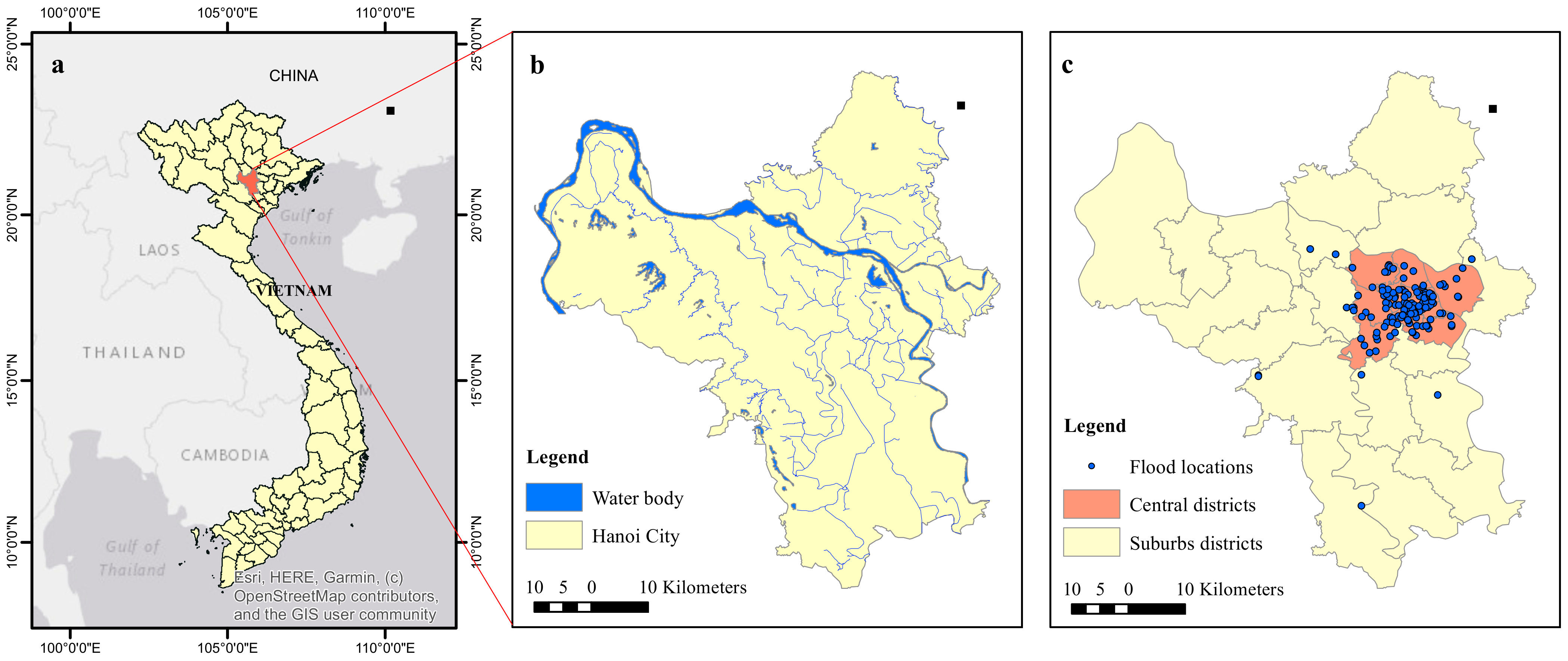
2. Study Area
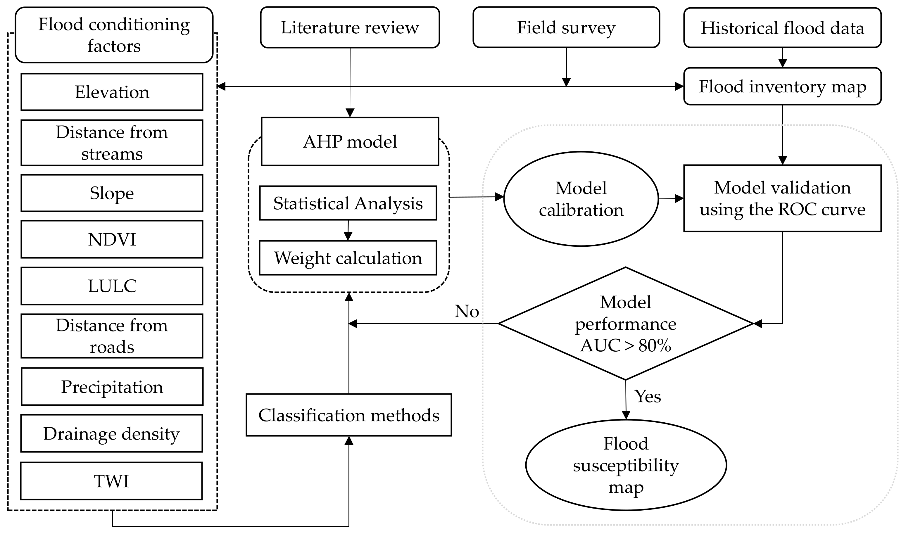
3. Materials and Methods
3.1. Data Preparation
3.1.1. Flood Inventory Mapping
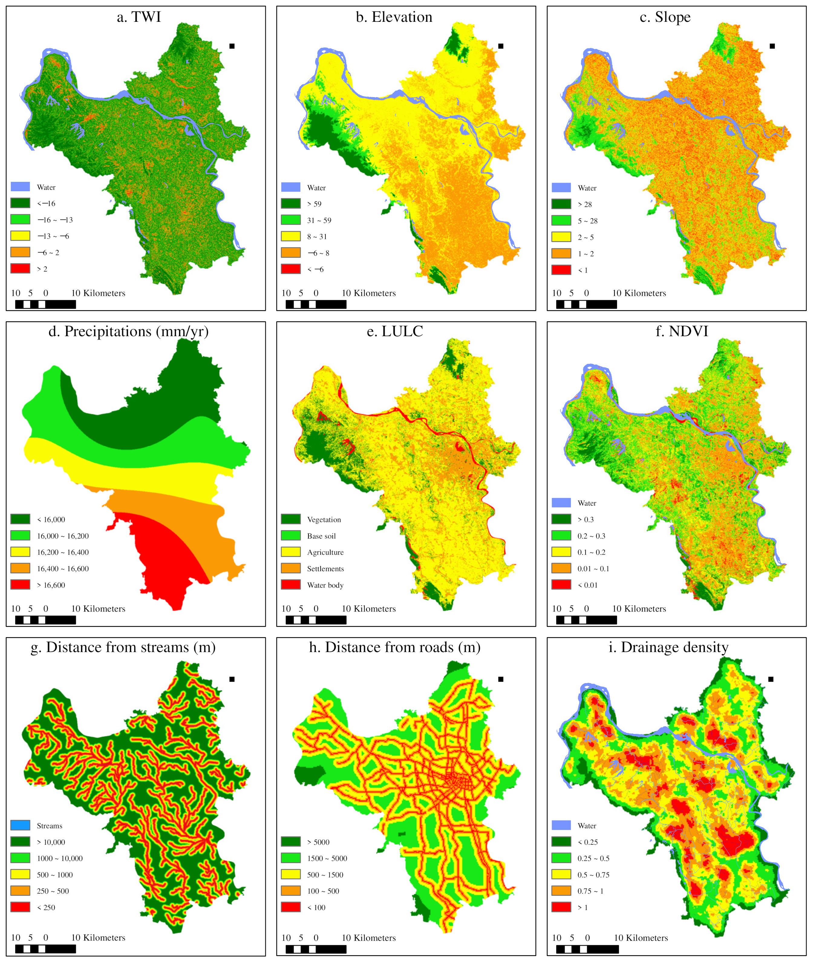
3.1.2. Flood-Conditioning Factors
- 1.
- Topographic Wetness Index (TWI)
- 2.
- Elevation and Slope
- 3.
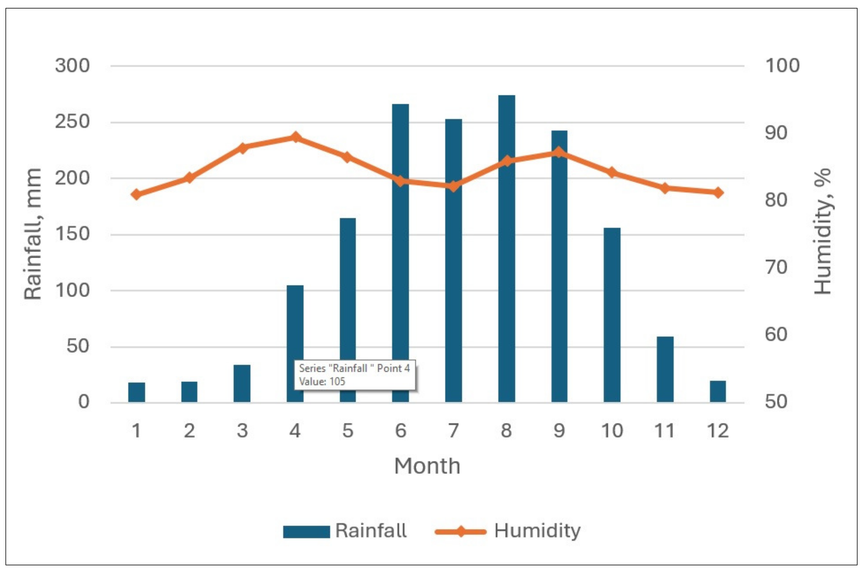
- Precipitation
- 4.
- Land Use/Land Cover (LULC)
- 5.
- Normalized difference vegetation index (NDVI)
- 6.
- Distance from streams
- 7.
- Distance from roads
- 8.
- Drainage density
3.2. Methods
- 1.
- A literature review, data collection, and preprocessing of the geographic spatial data, including field surveys and a compilation of historical flood points for the historical flood-inventory map;
- 2.
- The identification and selection of sensitive factors, followed by their evaluation and classification; then, weights were assigned to the factors using the AHP model;
- 3.
- Overlay analysis and the creation of the flood-susceptibility map using the GIS map overlay method;
- 4.
- Evaluation and validation of the effectiveness of the flood-susceptibility map using the ROC curve.
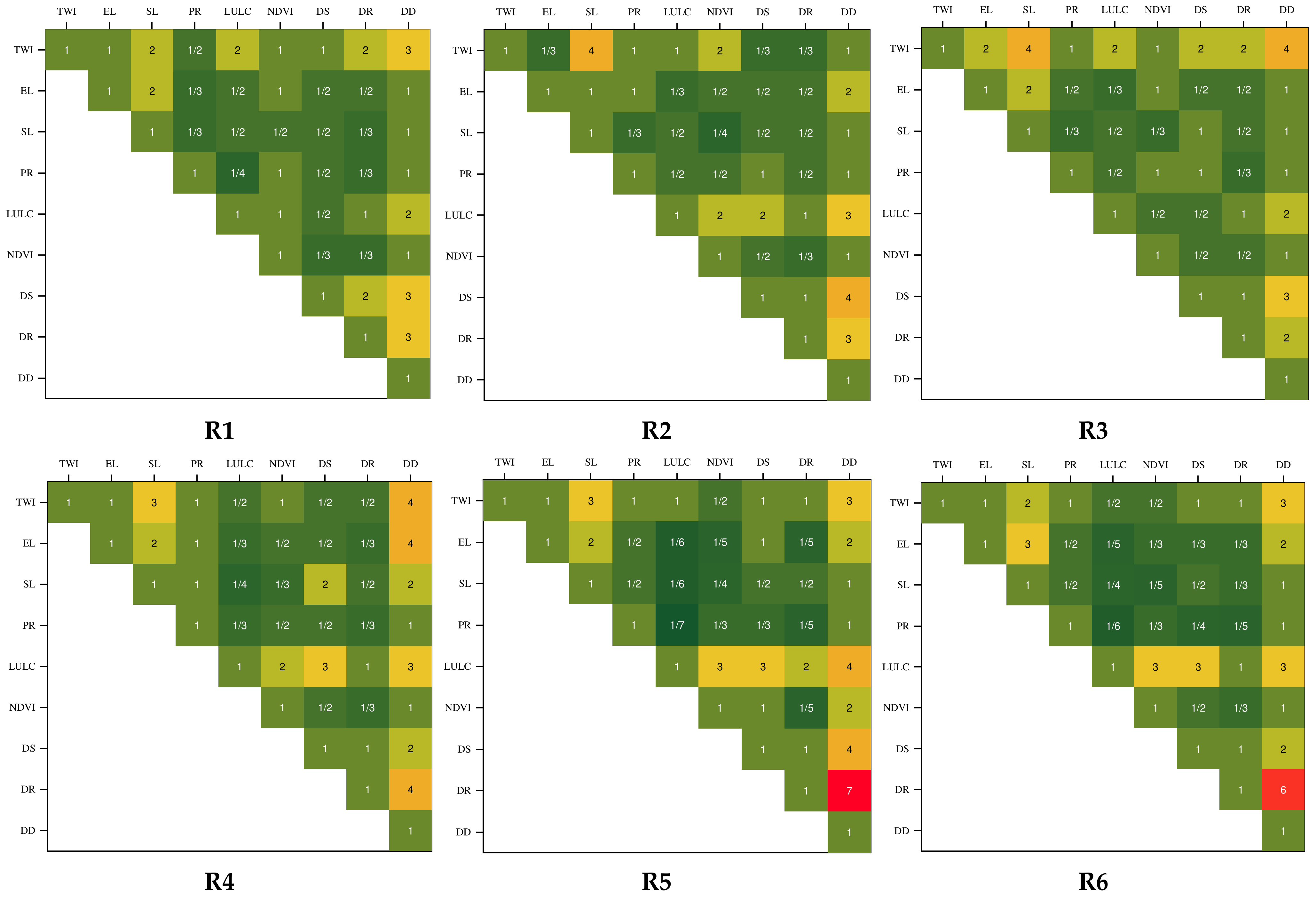
3.2.1. Analytic Hierarchy Process (AHP)
3.2.2. Survey of Experts and AHP Calculation
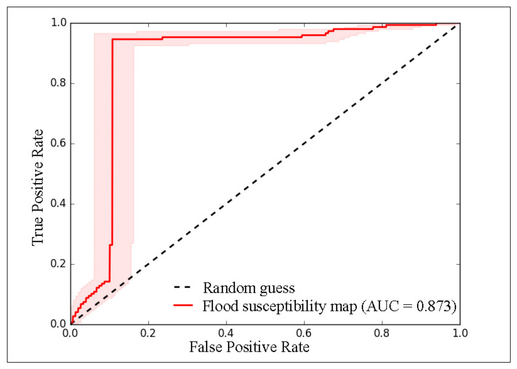
3.2.3. Validation of Model
4. Results
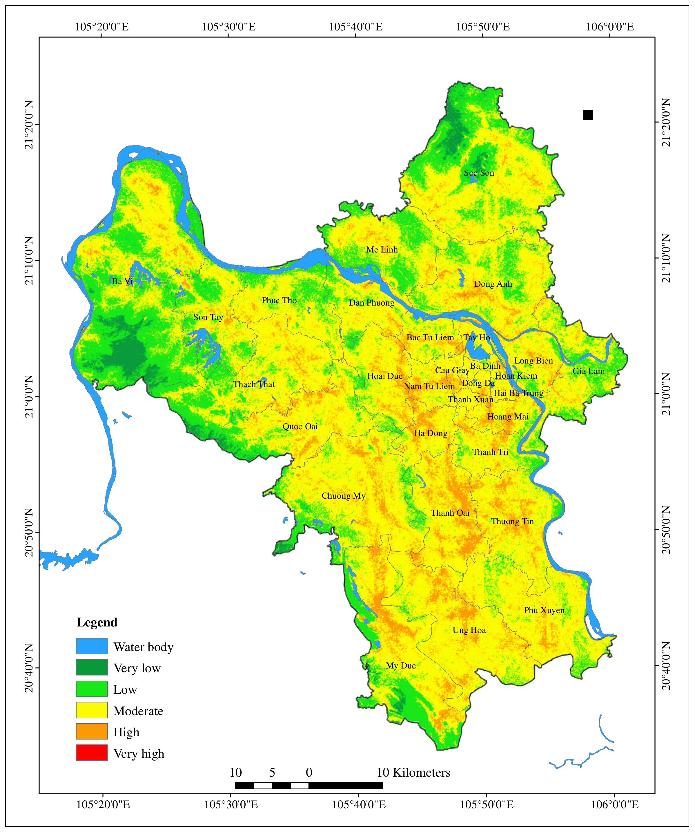
4.1. Flood-Susceptibility Assessment
4.2. Model Validation
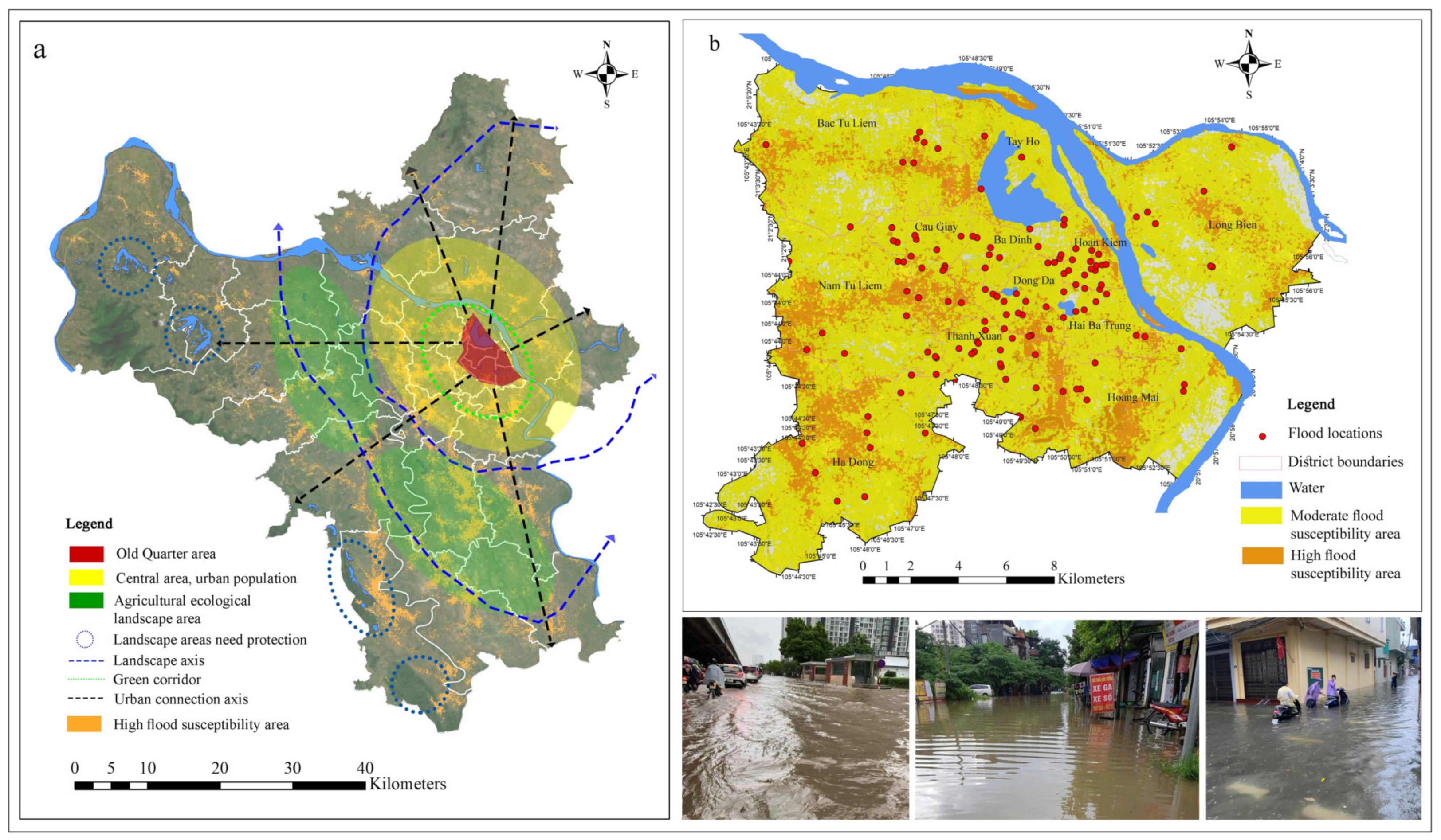
5. Discussion
5.1. Flood-Susceptibility Area
5.2. Analysis of General Flood-Susceptibility Planning
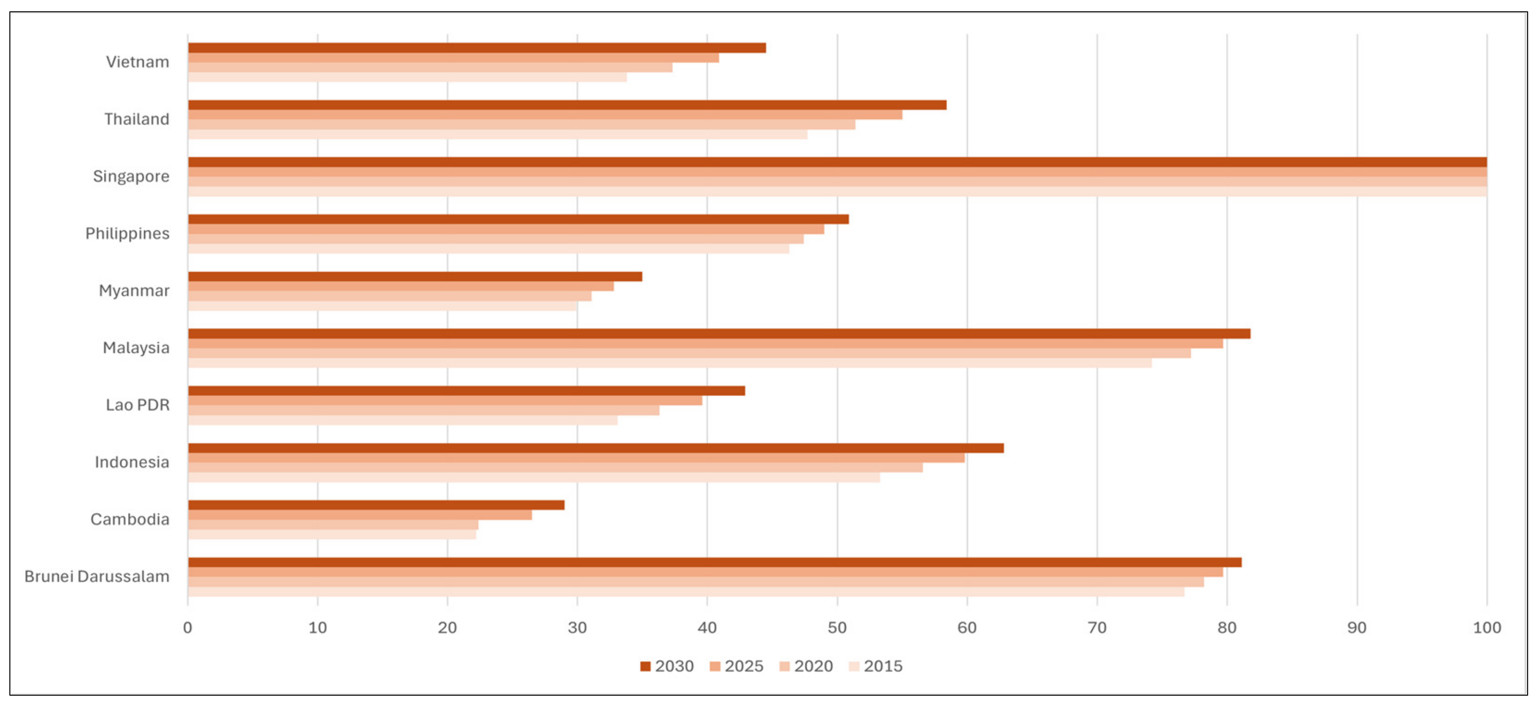
5.3. Regional Relevance
6. Conclusions
Author Contributions
Funding
Institutional Review Board Statement
Informed Consent Statement
Data Availability Statement
Conflicts of Interest
Appendix A

| Elevation | Slope | Drainage Density | TWI | Precipitation | LULC | NDVI | Distance from Streams | Distance from Roads | |
|---|---|---|---|---|---|---|---|---|---|
| Mahmoud, S.H. et al. [24] | x | x | x | x | x | x | |||
| Tehrany, M.S. et al. [51] | x | x | x | x | x | ||||
| Bera, S. et al. [52] | x | x | x | x | x | x | |||
| Nguyen, D.L. et al. [54] | x | x | x | x | x | x | x | x | |
| Costache, R. et al. [55] | x | x | x | x | x | x | |||
| Ali, S.A. et al. [63] | x | x | x | x | x | x | x | x | |
| Samanta, S. et al. [66] | x | x | x | ||||||
| Chaulagain, D. et al. [67] | x | x | x | x | x | x | |||
| Band, S.S. et al. [69] | x | x | x | x | x | ||||
| Nachappa, T.G. et al. [70] | x | x | x | x | x | x | x | x | |
| Zhao, G. et al. [91] | x | x | x | ||||||
| Arabameri, A. et al. [92] | x | x | x | x | x | x | x | ||
| Hong, H. et al. [93] | x | x | x | x | |||||
| Abinet Addis [94] | x | x | x | x | x | x | x | x | |
| Razavi-Termeh, S.V. et al. [95] | x | x | x | x | x | x |
| Intensity of Importance | Explanation |
|---|---|
| 1 | Equal importance |
| 3 | Slightly importance of one factor over another |
| 5 | Essential importance |
| 7 | Demonstrated importance |
| 9 | Absolute importance |
| 2,4,6,8 | Intermediate values between two adjacent judgments when compromise is required. |
Appendix B. Paired Comparison Results of Six Experts Using the AHP
Appendix C
References
- Ruan, J.; Chen, Y.; Yang, Z. Assessment of temporal and spatial progress of urban resilience in Guangzhou under rainstorm scenarios. Int. J. Disaster Risk Reduct. 2021, 66, 102578. [Google Scholar] [CrossRef]
- Nkeki, F.N.; Bello, E.I.; Agbaje, I.G. Flood risk mapping and urban infrastructural susceptibility assessment using a GIS and analytic hierarchical raster fusion approach in the Ona River Basin, Nigeria. Int. J. Disaster Risk Reduct. 2022, 77, 103097. [Google Scholar] [CrossRef]
- Najibi, N.; Devineni, N. Recent trends in the frequency and duration of global floods. Earth Syst. Dyn. 2018, 9, 757–783. [Google Scholar] [CrossRef]
- Tellman, B.; Sullivan, J.A.; Kuhn, C.; Kettner, A.J.; Doyle, C.S.; Brakenridge, G.R.; Erickson, T.A.; Slayback, D.A. Satellite imaging reveals increased proportion of population exposed to floods. Nature 2021, 596, 80–86. [Google Scholar] [CrossRef] [PubMed]
- World Meteorological Organization. WMO Atlas of Mortality and Economic Losses from Weather, Climate and Water Extremes (1970–2019); World Meteorological Organization: Geneva, Switzerland, 2021; pp. 16–21. [Google Scholar]
- International Federation of Red Cross and Red Crescent Societies (IFRC). World Disasters Report 2020: Come Heat or High Water; International Federation of Red Cross and Red Crescent Societies (IFRC): Geneva, Switzerland, 2020; pp. 50–55. [Google Scholar]
- Dhiman, R.; VishnuRadhan, R.; Eldho, T.I.; Inamdar, A. Flood risk and adaptation in Indian coastal cities: Recent scenarios. Appl. Water Sci. 2019, 9, 5. [Google Scholar] [CrossRef]
- Shao, Z.; Ding, L.; Li, D.; Altan, O.; Huq, E.; Li, C. Exploring the relationship between urbanization and ecological environment using remote sensing images and statistical data: A case study in the Yangtze River Delta, China. Sustainability 2020, 12, 5620. [Google Scholar] [CrossRef]
- Quan, R.S.; Liu, M.; Lu, M.; Zhang, L.J.; Wang, J.J.; Su, S.Y. Waterlogging risk assessment based on land use/cover change: A case study in Pudong New Area, Shanghai. Environ. Earth Sci. 2010, 61, 1113–1121. [Google Scholar] [CrossRef]
- Li, J.; Burian, S.J. Evaluating real-time control of stormwater drainage network and green stormwater infrastructure for enhancing flooding resilience under future rainfall projections. Resour. Conserv. Recycl. 2023, 198, 107123. [Google Scholar] [CrossRef]
- Li, L.; Uyttenhove, P.; Van Eetvelde, V.E. Planning green infrastructure to mitigate urban surface water flooding risk–A methodology to identify priority areas applied in the city of Ghent. Landsc. Urban Plan. 2020, 194, 103703. [Google Scholar] [CrossRef]
- Tramblay, Y.; Mimeau, L.; Neppel, L.; Vinet, F.; Sauquet, E. Detection and attribution of flood trends in Mediterranean basins. Hydrol. Earth Syst. Sci. 2019, 23, 4419–4431. [Google Scholar] [CrossRef]
- Ringo, J.; Sabai, S.; Mahenge, A. Performance of early warning systems in mitigating flood effects. A review. J. Afr. Earth Sci. 2023, 210, 105134. [Google Scholar] [CrossRef]
- Jose Moises, D.; Kunguma, O. Improving flood early warning systems in Kabbe, Namibia: A situational analysis approach. Int. J. Disaster Risk Reduct. 2023, 93, 103765. [Google Scholar] [CrossRef]
- Horita, F.E.A.; de Albuquerque, J.P.; Marchezini, V. Understanding the decision-making process in disaster risk monitoring and early-warning: A case study within a control room in Brazil. Int. J. Disaster Risk Reduct. 2018, 28, 22–31. [Google Scholar] [CrossRef]
- Darabi, H.; Choubin, B.; Rahmati, O.; Haghighi, A.T.; Pradhan, B.; Kløve, B. Urban flood risk mapping using the GARP and QUEST models: A comparative study of machine learning techniques. J. Hydrol. 2019, 569, 142–154. [Google Scholar] [CrossRef]
- Chen, J.; Hill, A.A.; Urbano, L.D. A GIS-based model for urban flood inundation. J. Hydrol. 2009, 373, 184–192. [Google Scholar] [CrossRef]
- Alam, S.; Rahman, A.; Yunus, A. Designing Stormwater Drainage Network for Urban Flood Mitigation using SWMM: A Case Study on Dhaka City of Bangladesh. Am. J. Water Resour. 2023, 11, 65–78. [Google Scholar] [CrossRef]
- Latt, Z.Z.; Wittenberg, H. Improving Flood Forecasting in a Developing Country: A Comparative Study of Stepwise Multiple Linear Regression and Artificial Neural Network. Water Resour. Manag. 2014, 28, 2109–2128. [Google Scholar] [CrossRef]
- Xiao, T.; Segoni, S.; Chen, L.; Yin, K.; Casagli, N. A step beyond landslide susceptibility maps: A simple method to investigate and explain the different outcomes obtained by different approaches. Landslides 2020, 17, 627–640. [Google Scholar] [CrossRef]
- Liu, L.L.; Zhang, Y.L.; Xiao, T.; Yang, C. A frequency ratio–based sampling strategy for landslide susceptibility assessment. Bull. Eng. Geol. Environ. 2022, 81, 360. [Google Scholar] [CrossRef]
- Trošelj, J.; Lee, H.S.; Hobohm, L. Enhancing a Real-Time Flash Flood Predictive Accuracy Approach for the Development of Early Warning Systems: Hydrological Ensemble Hindcasts and Parameterizations. Sustainability 2023, 15, 13897. [Google Scholar] [CrossRef]
- Guan, F.; Fang, Z.; Zhang, X.; Zhong, H.; Zhang, J.; Huang, H. Using street-view panoramas to model the decision-making complexity of road intersections based on the passing branches during navigation. Comput. Environ. Urban Syst. 2023, 103, 101975. [Google Scholar] [CrossRef]
- Mahmoud, S.H.; Gan, T.Y. Multi-criteria approach to develop flood susceptibility maps in arid regions of Middle East. J. Clean. Prod. 2018, 196, 216–229. [Google Scholar] [CrossRef]
- Saaty, T.L. The Analytic Hierarchy Process: Planning, Priority Setting, Resource Allocation, 2nd ed.; McGraw-Hill International Book Company: New York, NY, USA, 1980. [Google Scholar]
- Luu, C.; Tran, H.X.; Pham, B.T.; Al-Ansari, N.; Tran, T.Q.; Duong, N.Q.; Dao, N.H.; Nguyen, L.P.; Nguyen, H.D.; Ta, H.T.; et al. Framework of spatial flood risk assessment for a case study in Quang Binh province, Vietnam. Sustainability 2020, 12, 3058. [Google Scholar] [CrossRef]
- Chen, Y.R.; Yeh, C.H.; Yu, B. Integrated application of the analytic hierarchy process and the geographic information system for flood risk assessment and flood plain management in Taiwan. Nat. Hazards 2011, 59, 1261–1276. [Google Scholar] [CrossRef]
- Kazakis, N.; Kougias, I.; Patsialis, T. Assessment of flood hazard areas at a regional scale using an index-based approach and Analytical Hierarchy Process: Application in Rhodope-Evros region, Greece. Sci. Total Environ. 2015, 538, 555–563. [Google Scholar] [CrossRef] [PubMed]
- Schiermeier, Q. Increased flood risk linked to global warming. Nature 2011, 470, 316. [Google Scholar] [CrossRef] [PubMed]
- Nilawar, A.P.; Waikar, M.L. Impacts of climate change on streamflow and sediment concentration under RCP 4.5 and 8.5: A case study in Purna river basin, India. Sci. Total Environ. 2019, 650, 2685–2696. [Google Scholar] [CrossRef] [PubMed]
- Intergovernmental Panel on Climate Change (IPCC). Sections. In Climate Change 2023: Synthesis Report; Intergovernmental Panel on Climate Change (IPCC): Geneva, Switzerland, 2023; pp. 35–115. [Google Scholar] [CrossRef]
- Intergovernmental Panel on Climate Change (IPCC). Climate Change 2014: Impacts, Adaptation, and Vulnerability. Part A: Global and Sectoral Aspects; Cambridge University Press: New York, NY, USA, 2014; p. 1132. [Google Scholar]
- The Wold Bank. Turn Down the Heat: Climate Extremes, Regional Impacts, and the Case for Resilience; The World Bank: Washington, DC, USA, 2013; p. 213. [Google Scholar]
- Global Facility for Disaster Reduction and Recovery (GFDRR). Vulnerability, Risk Reduction, and Adaptation to Climate Change Viet Nam. In Climate Risk and Adaptation Country Profile; The World Bank: Washington, DC, USA, 2011; pp. 1–15. [Google Scholar]
- Global Facility for Disaster Reduction and Recovery (GFDRR). Country Profile: Vietnam; The World Bank: Washington, DC, USA, 2015. [Google Scholar]
- Bangalore, M.; Smith, A.; Veldkamp, T. Exposure to Floods, Climate Change, and Poverty in Vietnam. Econ. Disasters Clim. Change 2018, 3, 79–99. [Google Scholar] [CrossRef]
- Nguyen, H.; Tran, P. 9–Urban Disaster Risk Reduction in Vietnam: Gaps, Challenges, and Approaches. In Urban Disasters and Resilience in Asia; Elsevier: Amsterdam, The Netherlands, 2016; pp. 123–140. [Google Scholar] [CrossRef]
- Tran, D.; Xu, D.; Alwah, A.A.Q.; Liu, B. Research of Urban Suitable Ecological Land Based on the Minimum Cumulative Resistance Model: A Case Study from Hanoi, Vietnam. IOP Conf. Ser. Earth Environ. Sci. 2019, 300, 032084. [Google Scholar] [CrossRef]
- Tran, D.; Xu, D.; Dang, V.; Alwah, A.A.Q. Predicting urban waterlogging risks by regression models and internet open-data sources. Water 2020, 12, 879. [Google Scholar] [CrossRef]
- Luo, P.; Mu, D.; Xue, H.; Ngo-Duc, T.; Dang-Dinh, K.; Takara, K.; Nover, D.; Schladow, G. Flood inundation assessment for the Hanoi Central Area, Vietnam under historical and extreme rainfall conditions. Sci. Rep. 2018, 8, 12623. [Google Scholar] [CrossRef] [PubMed]
- Kefi, M.; Mishra, B.K.; Kumar, P.; Masago, Y.; Fukushi, K. Assessment of tangible direct flood damage using a spatial analysis approach under the effects of climate change: Case study in an urban watershed in Hanoi, Vietnam. ISPRS Int. J. Geo-Inf. 2018, 7, 29. [Google Scholar] [CrossRef]
- Hieu, N.; Hieu, T.; Kinh Bac, D.; Phương, T. Assessment of Flood Hazard in Hanoi City. VNU J. Earth Environ. Sci. 2013, 29, 26–37. [Google Scholar]
- Loi, D.T. Assessment of Urban Flood Vulnerability Using Integrated Multi-parametric AHP and GIS. Int. J. Geoinform. 2023, 19, 1–16. [Google Scholar]
- Seneviratne, S.I.; Zhang, X.; Adnan, M.; Badi, W.; Dereczynski, C.; Di Luca, A.; Ghosh, S.; Iskandar, I.; Kossin, J.; Lewis, S.; et al. Weather and Climate Extreme Events in a Changing Climate. In Climate Change 2021: The Physical Science Basis; Chan, J., Sorteberg, A., Vera, C., Eds.; Cambridge University Press: Cambridge, UK; New York, NY, USA, 2021; pp. 1513–1766. [Google Scholar] [CrossRef]
- van Horen, B. Hanoi. Cities 2005, 22, 161–173. [Google Scholar] [CrossRef]
- Pham, A.T.; Shannon, K.; Meulder, B.D. Water Urbanism in Hanoi, Vietnam: An Investigation into Possible Interplays of Infrastructure, Urbanism and Landscape of the City’s Dyke System. Ph.D. Thesis, Katholieke Universiteit Leuven, Leuven, The Netherlands, 22 April 2013. [Google Scholar]
- Chen, T.C.; Yen, M.C.; Tsay, J.D.; Thanh, N.T.T.; Alpert, J. Synoptic development of the Hanoi heavy rainfall event of 30–31 October 2008: Multiple-scale processes. Mon. Weather Rev. 2012, 140, 1219–1240. [Google Scholar] [CrossRef]
- Tang, X.; Shu, Y.; Lian, Y.; Zhao, Y.; Fu, Y. A spatial assessment of urban waterlogging risk based on a Weighted Naïve Bayes classifier. Sci. Total Environ. 2018, 630, 264–274. [Google Scholar] [CrossRef] [PubMed]
- Lai, C.; Chen, X.; Chen, X.; Wang, Z.; Wu, X.; Zhao, S. A fuzzy comprehensive evaluation model for flood risk based on the combination weight of game theory. Nat. Hazards 2015, 77, 1243–1259. [Google Scholar] [CrossRef]
- Zou, Q.; Zhou, J.; Zhou, C.; Song, L.; Guo, J. Comprehensive flood risk assessment based on set pair analysis-variable fuzzy sets model and fuzzy AHP. Stoch. Environ. Res. Risk Assess. 2013, 27, 525–546. [Google Scholar] [CrossRef]
- Tehrany, M.S.; Pradhan, B.; Jebur, M.N. Spatial prediction of flood susceptible areas using rule based decision tree (DT) and a novel ensemble bivariate and multivariate statistical models in GIS. J. Hydrol. 2013, 504, 69–79. [Google Scholar] [CrossRef]
- Bera, S.; Das, A.; Mazumder, T. Evaluation of machine learning, information theory and multi-criteria decision analysis methods for flood susceptibility mapping under varying spatial scale of analyses. Remote Sens. Appl. Soc. Environ. 2022, 25, 100686. [Google Scholar] [CrossRef]
- Assumpção, T.H.; Popescu, I.; Jonoski, A.; Solomatine, D.P. Citizen observations contributing to flood modelling: Opportunities and challenges. Hydrol. Earth Syst. Sci. 2018, 22, 1473–1489. [Google Scholar] [CrossRef]
- Nguyen, D.L.; Chou, T.Y.; Chen, M.H.; Hoang, T.V.; Tran, T.P.; Ngo, T.S.; Do Thi, N.A.; Bui, T.H.; Nguyen, Q.H. Flood Susceptibility Assessment in Central Region of Vietnam Based on Ensemble Fuzzy Logic and Multivariate Analysis. Urban. Archit. Constr. 2022, 13, 29–44. [Google Scholar]
- Costache, R.; Țîncu, R.; Elkhrachy, I.; Pham, Q.B.; Popa, M.C.; Diaconu, D.C.; Avand, M.; Costache, I.; Arabameri, A.; Bui, D.T. New neural fuzzy-based machine learning ensemble for enhancing the prediction accuracy of flood susceptibility mapping. Hydrol. Sci. J. 2020, 65, 2816–2837. [Google Scholar] [CrossRef]
- Pradhan, B. Flood susceptible mapping and risk area delineation using logistic regression, GIS and remote sensing. J. Spat. Hydrol. 2010, 9, 1–18. [Google Scholar]
- Fernández, D.S.; Lutz, M.A. Urban flood hazard zoning in Tucumán Province, Argentina, using GIS and multicriteria decision analysis. Eng. Geol. 2010, 111, 90–98. [Google Scholar] [CrossRef]
- Dahri, N.; Abida, H. Monte Carlo simulation-aided analytical hierarchy process (AHP) for flood susceptibility mapping in Gabes Basin (southeastern Tunisia). Environ. Earth Sci. 2017, 76, 302. [Google Scholar] [CrossRef]
- Mahmoud, S.H.; Tang, X. Monitoring prospective sites for rainwater harvesting and stormwater management in the United Kingdom using a GIS-based decision support system. Environ. Earth Sci. 2015, 73, 8621–8638. [Google Scholar] [CrossRef]
- Seejata, K.; Yodying, A.; Wongthadam, T.; Mahavik, N.; Tantanee, S. Assessment of flood hazard areas using Analytical Hierarchy Process over the Lower Yom Basin, Sukhothai Province. Procedia Eng. 2018, 212, 340–347. [Google Scholar] [CrossRef]
- Roy, S.; Bose, A.; Chowdhury, I.R. Flood risk assessment using geospatial data and multi-criteria decision approach: A study from historically active flood-prone region of Himalayan foothill, India. Arab. J. Geosci. 2021, 14, 999. [Google Scholar] [CrossRef]
- Saha, A.K.; Agrawal, S. Mapping and assessment of flood risk in Prayagraj district, India: A GIS and remote sensing study. Nanotechnol. Environ. Eng. 2020, 5, 11. [Google Scholar] [CrossRef]
- Ali, S.A.; Parvin, F.; Pham, Q.B.; Vojtek, M.; Vojteková, J.; Costache, R.; Nguyen, T.T.L.; Nguyen, H.Q.; Ahmad, A.; Ghorbani, M.A. GIS-based comparative assessment of flood susceptibility mapping using hybrid multi-criteria decision-making approach, naïve Bayes tree, bivariate statistics and logistic regression: A case of Topľa basin, Slovakia. Ecol. Indic. 2020, 117, 106620. [Google Scholar] [CrossRef]
- Pantaleoni, E.; Engel, B.A.; Johannsen, C.J. Identifying agricultural flood damage using Landsat imagery. Precis. Agric. 2007, 8, 27–36. [Google Scholar] [CrossRef]
- Parvin, F.; Ali, S.A.; Calka, B.; Bielecka, E.; Nguyen, T.T.L.; Pham, Q.B. Urban flood vulnerability assessment in a densely urbanized city using multi-factor analysis and machine learning algorithms. Theor. Appl. Climatol. 2022, 149, 639–659. [Google Scholar] [CrossRef]
- Samanta, S.; Pal, D.K.; Palsamanta, B. Flood susceptibility analysis through remote sensing, GIS and frequency ratio model. Appl. Water Sci. 2018, 8, 66. [Google Scholar] [CrossRef]
- Chaulagain, D.; Rimal, P.R.; Ngando, S.N.; Nsafon, B.E.K.; Suh, D.; Huh, J.S. Flood susceptibility mapping of Kathmandu metropolitan city using GIS-based multi-criteria decision analysis. Ecol. Indic. 2023, 154, 110653. [Google Scholar] [CrossRef]
- Mahmoud, S.H.; Gan, T.Y. Urbanization and climate change implications in flood risk management: Developing an efficient decision support system for flood susceptibility mapping. Sci. Total Environ. 2018, 636, 152–167. [Google Scholar] [CrossRef] [PubMed]
- Band, S.S.; Janizadeh, S.; Pal, S.C.; Saha, A.; Chakrabortty, R.; Melesse, A.M.; Mosavi, A. Flash flood susceptibility modeling using new approaches of hybrid and ensemble tree-based machine learning algorithms. Remote Sens. 2020, 12, 3568. [Google Scholar] [CrossRef]
- Nachappa, T.G.; Piralilou, S.T.; Gholamnia, K.; Ghorbanzadeh, O.; Rahmati, O.; Blaschke, T. Flood susceptibility mapping with machine learning, multi-criteria decision analysis and ensemble using Dempster Shafer Theory. J. Hydrol. 2020, 590, 125275. [Google Scholar] [CrossRef]
- Elkhrachy, I. Flash Flood Hazard Mapping Using Satellite Images and GIS Tools: A case study of Najran City, Kingdom of Saudi Arabia (KSA). Egypt. J. Remote Sens. Space Sci. 2015, 18, 261–278. [Google Scholar] [CrossRef]
- Kumar, P.K.D.; Gopinath, G.; Seralathan, P. Application of remote sensing and GIS for the demarcation of groundwater potential zones of a river basin in Kerala, southwest coast of India. Int. J. Remote Sens. 2007, 28, 5583–5601. [Google Scholar] [CrossRef]
- Ogden, F.L.; Raj Pradhan, N.; Downer, C.W.; Zahner, J.A. Relative importance of impervious area, drainage density, width function, and subsurface storm drainage on flood runoff from an urbanized catchment. Water Resour. Res. 2011, 47, W12503. [Google Scholar] [CrossRef]
- Saaty, T.L. Decision making with the analytic hierarchy process. Int. J. Serv. Sci. 2008, 1, 83–97. [Google Scholar] [CrossRef]
- Hoang, L.H.G.; Kato, T. Use of analytic hierarchy process and four-component instructional design for improving emergency response exercises. Int. J. Disaster Risk Reduct. 2023, 87, 103583. [Google Scholar] [CrossRef]
- Cabrera, J.S.; Lee, H.S. Flood-prone area assessment using GIS-based multi-criteria analysis: A case study in Davao Oriental, Philippines. Water 2019, 11, 2203. [Google Scholar] [CrossRef]
- Saaty, T.L. Decision Making for Leaders: The Analytical Hierarchy Process for Decisions in a Complex World, 3rd ed.; RWS Publications: Pittsburgh, PA, USA, 2012. [Google Scholar]
- Yadollahi, M.; Rosli, M.Z. Development of the Analytical Hierarchy Process (AHP) method for rehabilitation project ranking before disasters. WIT Trans. Built Environ. 2011, 119, 209–220. [Google Scholar] [CrossRef]
- Nivolianitou, Z.; Synodinou, B.; Manca, B. Flood Disaster Management with the Use of Ahp. Int. J. Multicriteria Decis. Mak. 2015, 5, 152–164. [Google Scholar] [CrossRef]
- Saaty, T.L. How to make a decision: The Analytic Hierarchy Process. Eur. J. Oper. Res. 1990, 48, 9–26. [Google Scholar] [CrossRef]
- Avand, M.; Moradi, H.; Lasboyee, M.R. Spatial modeling of flood probability using geo-environmental variables and machine learning models, case study: Tajan watershed, Iran. Adv. Space Res. 2021, 67, 3169–3186. [Google Scholar] [CrossRef]
- Arabameri, A.; Rezaei, K.; Cerdà, A.; Conoscenti, C.; Kalantari, Z. A comparison of statistical methods and multi-criteria decision making to map flood hazard susceptibility in Northern Iran. Sci. Total Environ. 2019, 660, 443–458. [Google Scholar] [CrossRef]
- Yesilnacar, E.; Topal, T. Landslide susceptibility mapping: A comparison of logistic regression and neural networks methods in a medium scale study, Hendek region (Turkey). Eng. Geol. 2005, 79, 251–266. [Google Scholar] [CrossRef]
- Tran, D.; Xu, D.; Dang, V.; Fadelelseed, S. Exploring the Relationships between Impervious Surface Percentage and Frequency of Urban Waterlogging: A Case Study in Hanoi, Vietnam. IOP Conf. Ser. Earth Environ. Sci. 2020, 440, 052073. [Google Scholar] [CrossRef]
- Burton, I.; Kates, R.W.; White, G.F. The Environment as Hazard, 2nd ed.; Oxford University Press: Oxford, UK; University of California: Los Angeles, CA, USA, 1993. [Google Scholar]
- Chuan, G.K. The Climate of Southeast Asia. In the Physical Geography of Southeast Asia; Gupta, A., Ed.; Oxford University Press: Oxford, UK; New York, NY, USA, 2005. [Google Scholar] [CrossRef]
- Association of Southeast Asian Nations (ASEAN). Asean Sustainable Urbanisation Report: Sustainable Cities Towards 2025 and Beyond; ASEAN Secretariat Community Relations Division (CRD): Jakarta, Indonesia, 2022. [Google Scholar]
- Dekker, G.; Gutterer, B.; McNamara, I.; Westermann, J.; Wilk-Pham, A. Responding to Urban Water Challenges in Southeast Asia: Introducing Polycentric Management Approaches to Create Resilient, Water-Sensitive Cities; Gutterer, B., Misselwitz, P., Ribbe, L., Eds.; BORDA e.V.: Bremen, Germany, 2021. [Google Scholar]
- Association of Southeast Asian Nations (ASEAN). Towards Strengthening Cooperation for Urban Resilience in ASEAN: Scoping Paper Focusing on Aspects of Climate Change Adaptation, Disaster Risk Management, and Sustainable Urban Development; ASEAN Secretariat Community Relations Division (CRD): Jakarta, Indonesia, 2024. [Google Scholar]
- Makonyo, M.; Msabi, M.M. Identification of groundwater potential recharge zones using GIS-based multi-criteria decision analysis: A case study of semi-arid midlands Manyara fractured aquifer, North-Eastern Tanzania. Remote Sens. Appl. Soc. Environ. 2021, 23, 100544. [Google Scholar] [CrossRef]
- Zhao, G.; Pang, B.; Xu, Z.; Yue, J.; Tu, T. Mapping flood susceptibility in mountainous areas on a national scale in China. Sci. Total Environ. J. 2018, 615, 1133–1142. [Google Scholar] [CrossRef] [PubMed]
- Arabameri, A.; Danesh, A.S.; Santosh, M.; Cerda, A.; Pal, S.C.; Ghorbanzadeh, O.; Roy, P.; Chowdhuri, I. Flood susceptibility mapping using meta-heuristic algorithms. Geomat. Nat. Hazards Risk 2022, 1, 949–974. [Google Scholar] [CrossRef]
- Hong, H.; Tsangaratos, P.; Ilia, I.; Liu, J.; Zhu, A.X.; Chen, W. Application of fuzzy weight of evidence and data mining techniques in construction of flood susceptibility map of Poyang County, China. Sci. Total Environ. 2018, 625, 575–588. [Google Scholar] [CrossRef] [PubMed]
- Abinet, A. GIS-based flood susceptibility mapping using frequency ratio and information value models in upper Abay river basin, Ethiopia. Nat. Hazards Res. J. 2023, 3, 247–256. [Google Scholar] [CrossRef]
- Razavi-Termeh, S.V.; Seo, M.B.; Sadeghi-Niaraki, A.; Choi, S.M. Flash flood detection and susceptibility mapping in the Monsoon period by integration of optical and radar satellite imagery using an improvement of a sequential ensemble algorithm. Weather. Clim. Extrem. 2023, 41, 100595. [Google Scholar] [CrossRef]

| № | Dataset | Source | Classification Methods |
|---|---|---|---|
| 1 | SRTM DEM | https://earthexplorer.usgs.gov/, accessed on 1 May 2023. | |
| 2 | Elevation | https://earthexplorer.usgs.gov/, accessed on 20 May 2023. | Natural break |
| 3 | Distance from streams | SRTM DEM | Supervised classification |
| 4 | Slope | SRTM DEM | Supervised classification |
| 5 | NDVI | Landsat 8 The United States Geological Survey (http://www.usgs.gov/, accessed on 1 June 2023) | Natural break |
| 6 | LULC | https://earthexplorer.usgs.gov/, accessed on 31 May 2023. | Supervised classification |
| 7 | Distance from roads | Open street map/Field survey | Manual |
| 8 | Precipitation | High-resolution gridded datasetsClimatic Research Unit (CRU) | Natural break |
| 9 | Drainage density | SRTM DEM | Natural break |
| 10 | TWI | SRTM DEM | Natural break |
| Class Rating | Factor | ||||||||
|---|---|---|---|---|---|---|---|---|---|
| TWI | Elevation | Slope | Precipitation | LULC | NDVI | Distance from Streams | Distance from Roads | Drainage Density | |
| 1 | <−16 | >59 | >28 | <16 | Vegetation | >0.3 | >10,000 | >5000 | <0.25 |
| 2 | −16–(−13) | 31–59 | 5–28 | 16–16.2 | Base soil | 0.2–0.3 | 1000–10,000 | 1500–5000 | 0.25–0.5 |
| 3 | −13–(−6) | 8–31 | 2–5 | 16.2–16.4 | Agriculture | 0.1–0.2 | 500–1000 | 500–1500 | 0.5–0.75 |
| 4 | −6–2 | −6–8 | 1–2 | 16.4–16.6 | Settlements | 0.01–0.1 | 250–500 | 100–500 | 0.75–1 |
| 5 | >2 | <−6 | <1 | >16.6 | Water body | <0.01 | <250 | <100 | >1 |
| n | 3 | 4 | 5 | 6 | 7 | 8 | 9 | 10 | 11 |
|---|---|---|---|---|---|---|---|---|---|
| RI | 0.58 | 0.9 | 1.12 | 1.24 | 1.32 | 1.41 | 1.45 | 1.49 | 1.51 |
| TWI | Elevation | Slope | Precipitation | LULC | NDVI | Distance from Streams | Distance from Roads | Drainage Density | |
|---|---|---|---|---|---|---|---|---|---|
| TWI | 1 | 1 | 3 | 1 | 1 | 1 | 1 | 1 | 3 |
| Elevation | 1 | 1 | 2 | 1/2 | 1/3 | 1/2 | 1/2 | 1/3 | 2 |
| Slope | 1/3 | 1/2 | 1 | 1/2 | 1/3 | 1/3 | 1 | 1/2 | 1 |
| Precipitation | 1 | 2 | 2 | 1 | 1/3 | 1/2 | 1/2 | 1/3 | 1 |
| LULC | 1 | 3 | 3 | 3 | 1 | 2 | 2 | 1 | 3 |
| NDVI | 1 | 2 | 3 | 2 | 1/2 | 1 | 1/2 | 1/3 | 1 |
| Distance from streams | 1 | 2 | 1 | 2 | 1/2 | 2 | 1 | 1 | 3 |
| Distance from roads | 1 | 3 | 2 | 3 | 1 | 3 | 1 | 1 | 4 |
| Drainage density | 1/3 | 1/2 | 1 | 1 | 1/3 | 1 | 1/3 | 1/4 | 1 |
| TWI | Elevation | Slope | Precipitation | LULC | NDVI | Distance from Streams | Distance from Roads | Drainage Density | |
|---|---|---|---|---|---|---|---|---|---|
| TWI | 0.130 | 0.067 | 0.167 | 0.071 | 0.188 | 0.088 | 0.128 | 0.174 | 0.158 |
| Elevation | 0.130 | 0.067 | 0.111 | 0.036 | 0.063 | 0.044 | 0.064 | 0.058 | 0.105 |
| Slope | 0.043 | 0.033 | 0.056 | 0.036 | 0.063 | 0.029 | 0.128 | 0.087 | 0.053 |
| Precipitation | 0.130 | 0.133 | 0.111 | 0.071 | 0.063 | 0.044 | 0.064 | 0.058 | 0.053 |
| LULC | 0.130 | 0.200 | 0.167 | 0.214 | 0.188 | 0.176 | 0.255 | 0.174 | 0.158 |
| NDVI | 0.130 | 0.133 | 0.167 | 0.143 | 0.094 | 0.088 | 0.064 | 0.058 | 0.053 |
| Distance from streams | 0.130 | 0.133 | 0.056 | 0.143 | 0.094 | 0.176 | 0.128 | 0.174 | 0.158 |
| Distance from roads | 0.130 | 0.200 | 0.111 | 0.214 | 0.188 | 0.265 | 0.128 | 0.174 | 0.211 |
| Drainage density | 0.043 | 0.033 | 0.056 | 0.071 | 0.063 | 0.088 | 0.043 | 0.043 | 0.053 |
| Factors | Weight | Rank |
|---|---|---|
| TWI | 0.130 | 4 |
| Elevation | 0.075 | 7 |
| Slope | 0.059 | 8 |
| Precipitation | 0.08 | 6 |
| LULC | 0.185 | 1 |
| NDVI | 0.103 | 5 |
| Distance from streams | 0.132 | 3 |
| Distance from roads | 0.18 | 2 |
| Drainage density | 0.055 | 9 |
| Level | Low | Moderate | High | Very High | Total |
|---|---|---|---|---|---|
| Area (km2) | 47.158 | 401.407 | 110.897 | 0.334 | 559.796 |
Disclaimer/Publisher’s Note: The statements, opinions and data contained in all publications are solely those of the individual author(s) and contributor(s) and not of MDPI and/or the editor(s). MDPI and/or the editor(s) disclaim responsibility for any injury to people or property resulting from any ideas, methods, instructions or products referred to in the content. |
© 2024 by the authors. Licensee MDPI, Basel, Switzerland. This article is an open access article distributed under the terms and conditions of the Creative Commons Attribution (CC BY) license (https://creativecommons.org/licenses/by/4.0/).
Share and Cite
Nguyen, H.N.; Fukuda, H.; Nguyen, M.N. Assessment of the Susceptibility of Urban Flooding Using GIS with an Analytical Hierarchy Process in Hanoi, Vietnam. Sustainability 2024, 16, 3934. https://doi.org/10.3390/su16103934
Nguyen HN, Fukuda H, Nguyen MN. Assessment of the Susceptibility of Urban Flooding Using GIS with an Analytical Hierarchy Process in Hanoi, Vietnam. Sustainability. 2024; 16(10):3934. https://doi.org/10.3390/su16103934
Chicago/Turabian StyleNguyen, Hong Ngoc, Hiroatsu Fukuda, and Minh Nguyet Nguyen. 2024. "Assessment of the Susceptibility of Urban Flooding Using GIS with an Analytical Hierarchy Process in Hanoi, Vietnam" Sustainability 16, no. 10: 3934. https://doi.org/10.3390/su16103934
APA StyleNguyen, H. N., Fukuda, H., & Nguyen, M. N. (2024). Assessment of the Susceptibility of Urban Flooding Using GIS with an Analytical Hierarchy Process in Hanoi, Vietnam. Sustainability, 16(10), 3934. https://doi.org/10.3390/su16103934