
The Integration of Dual Evaluation and Minimum Spanning Tree Clustering to Support Decision-Making in Territorial Spatial Planning


Abstract
1. Introduction
2. Related Works
2.1. China’s Territorial Spatial Planning System
2.2. Decision-Making Process in TSP
3. Research Materials
3.1. Study Area
3.2. Data Source
4. Methodology
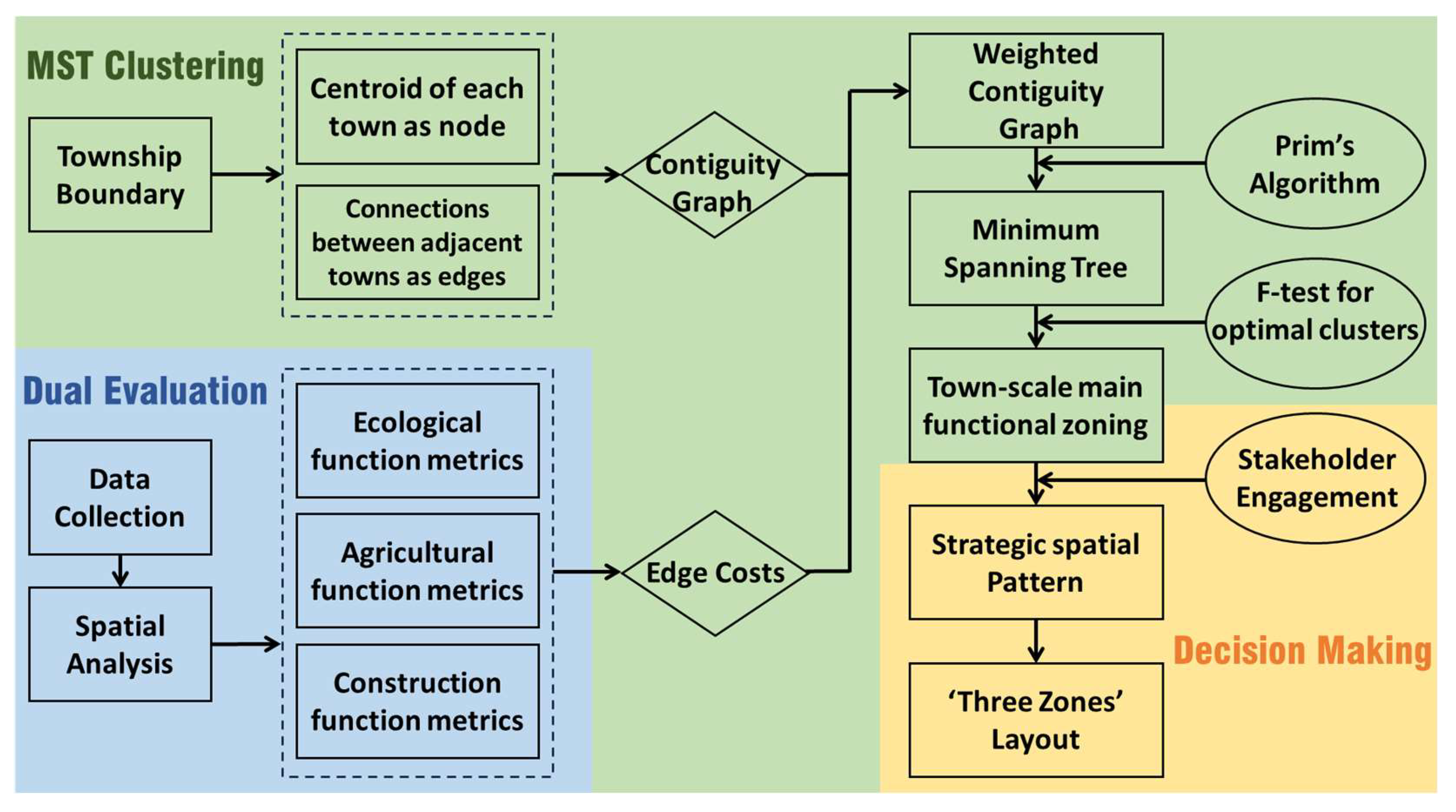
4.1. Methodological Framework
4.2. Evaluation Indicator System
4.3. Evaluation Method
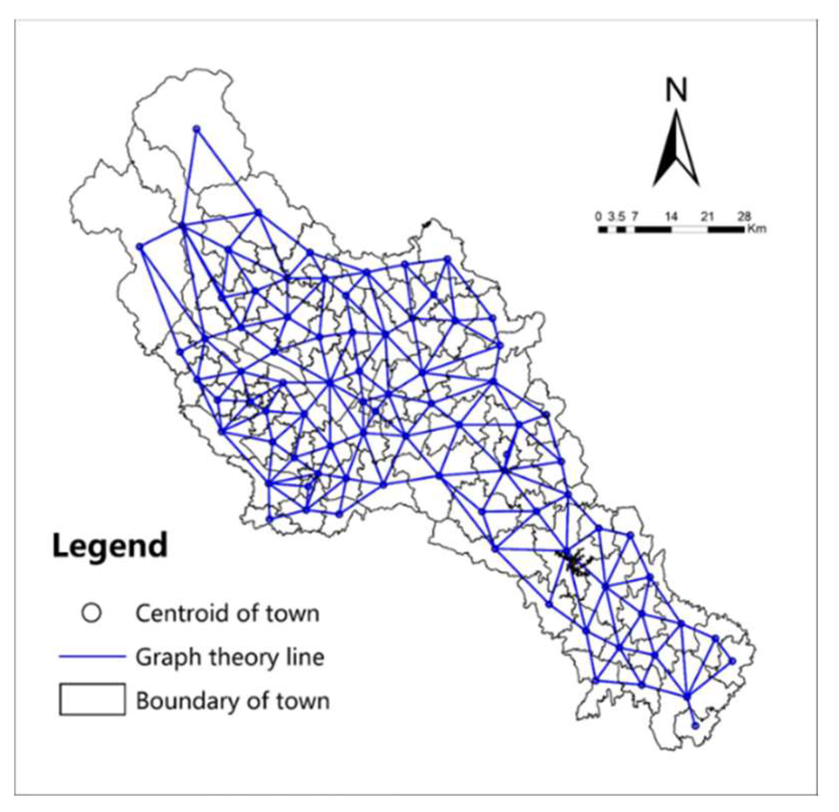
4.4. Minimum Spanning Tree-Based Clustering
5. Results
5.1. ‘Dual-Evaluation’ Results
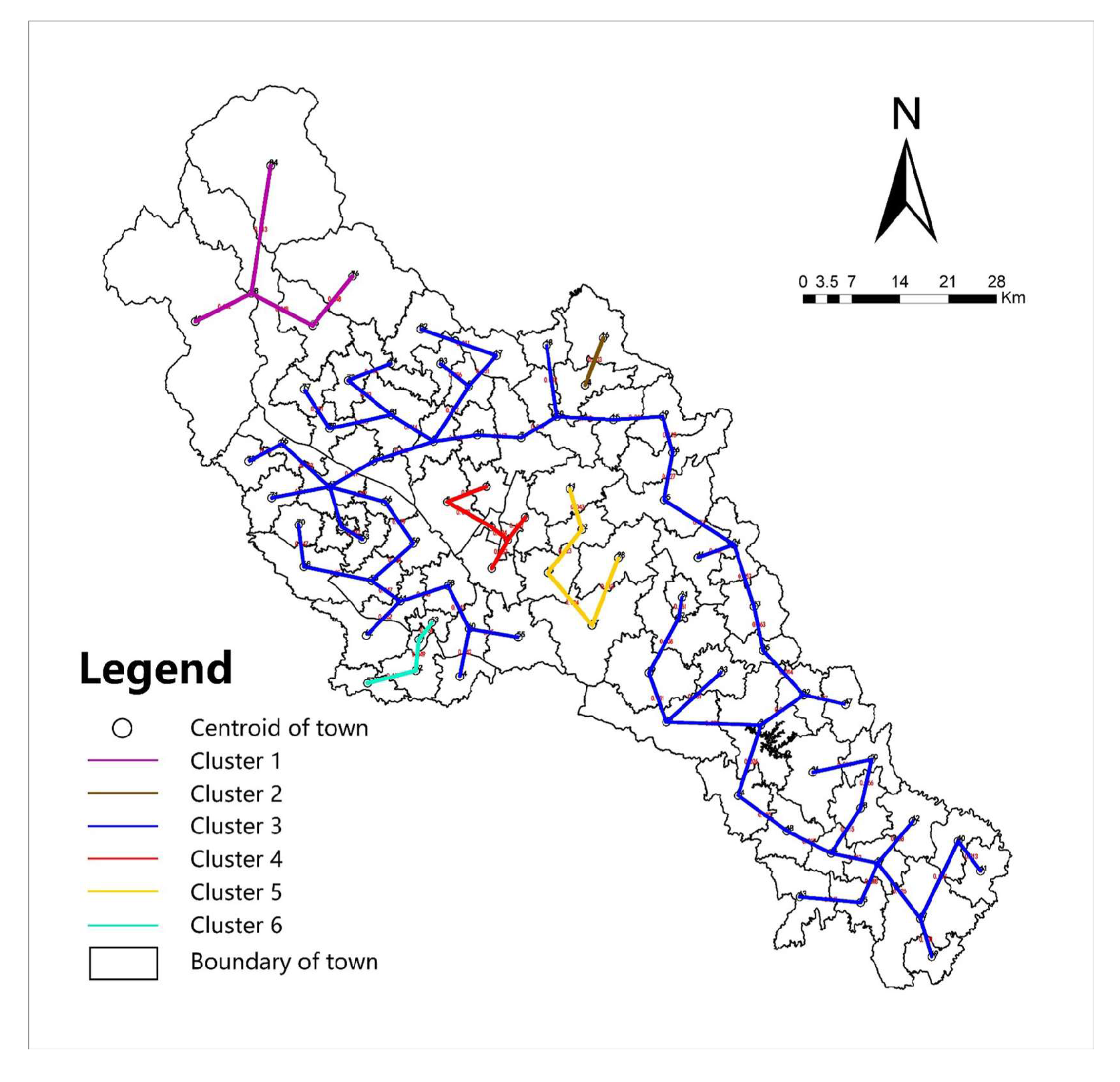
5.2. Town-Scale Main Functional Zoning
5.3. Strategic Spatial Pattern and Three-Zone Layout
6. Discussion
7. Conclusions
Author Contributions
Funding
Institutional Review Board Statement
Informed Consent Statement
Data Availability Statement
Conflicts of Interest
Abbreviations
| TSP | Territorial spatial planning |
| DE | Dual evaluation model |
| EREC | Evaluation of resource and environmental carrying capacity |
| ETDS | Evaluation of the suitability of territorial development |
| IEP | Importance of ecological protection |
| SAP | Suitability of agricultural production |
| SUC | Suitability of urban construction |
| MST | Minimum Spanning Tree |
| MFZ | Main function zoning |
| SSP | Strategic spatial pattern |
| TZL | Three-zone layout |
References
- Spence, M.; Annez, P.C.; Buckley, R.M. Urbanization and Growth; World Bank Publications: Washington, DC, USA, 2008. [Google Scholar]
- Faludi, A. The performance of spatial planning. Plan. Pract. Res. 2000, 15, 299–318. [Google Scholar] [CrossRef]
- Yoshida, T.; Yamagata, Y.; Chang, S.; de Gooyert, V.; Seya, H.; Murakami, D.; Jittrapirom, P.; Voulgaris, G. Spatial modeling and design of smart communities. In Urban Systems Design; Elsevier: Amsterdam, The Netherlands, 2020; pp. 199–255. [Google Scholar]
- Stead, D.; Nadin, V. Spatial Planning. Key Instrument for Development and Effective Governance with Special Reference to Countries in Transition; United Nations: New York, NY, USA, 2008. [Google Scholar]
- Sutherland, L.-A.; Barnes, A.; McCrum, G.; Blackstock, K.; Toma, L. Towards a cross-sectoral analysis of land use decision-making in Scotland. Landsc. Urban Plan. 2011, 100, 1–10. [Google Scholar] [CrossRef]
- Liu, A. Pursued Economy: Understanding and Overcoming the Challenging New Realities for Advanced Economies; Koo, R.C., Ed.; SAGE Publications Sage UK: London, UK, 2024. [Google Scholar]
- Wu, F. Francis Planning for Growth: Urban and Regional Planning in China; Routledge: New York, NY, USA, 2015. [Google Scholar]
- Fu, H.; Liu, J.; Dong, X.; Chen, Z.; He, M. Evaluating the Sustainable Development Goals within Spatial Planning for Decision-Making: A Major Function-Oriented Zone Planning Strategy in China. Land 2024, 13, 390. [Google Scholar] [CrossRef]
- Dejeant-Pons, M. Council of Europe Conference of Ministers Responsible for Spatial/Regional Planning (CEMAT): 1970–2010. Basic Texts. 2010; Volume 3. Available online: https://www.google.com/books/edition/Council_of_Europe_Conference_of_Minister/uWJ2bjSqNKsC?hl=en&gbpv=0 (accessed on 23 February 2024).
- Christmann, G.B.; Ibert, O.; Jessen, J.; Walther, U.-J. Innovations in spatial planning as a social process—Phases, actors, conflicts. Eur. Plan. Stud. 2020, 28, 496–520. [Google Scholar] [CrossRef]
- Ma, S.; Cai, Y.; Xie, D.; Zhang, X.; Zhao, Y. Towards balanced development stage: Regulating the spatial pattern of agglomeration with collaborative optimal allocation of urban land. Cities 2022, 126, 103645. [Google Scholar] [CrossRef]
- Albert, C.; Fürst, C.; Ring, I.; Sandström, C. Research note: Spatial planning in Europe and Central Asia–Enhancing the consideration of biodiversity and ecosystem services. Landsc. Urban Plan. 2020, 196, 103741. [Google Scholar] [CrossRef]
- Granqvist, K.; Humer, A.; Mäntysalo, R. Tensions in city-regional spatial planning: The challenge of interpreting layered institutional rules. Reg. Stud. 2021, 55, 844–856. [Google Scholar] [CrossRef]
- Nadin, V.; Stead, D.; Dąbrowski, M.; Fernandez-Maldonado, A.M. Integrated, adaptive and participatory spatial planning: Trends across Europe. Reg. Stud. 2021, 55, 791–803. [Google Scholar] [CrossRef]
- Schmid, F.B.; Kienast, F.; Hersperger, A.M. The compliance of land-use planning with strategic spatial planning–insights from Zurich, Switzerland. Eur. Plan. Stud. 2021, 29, 1231–1250. [Google Scholar] [CrossRef]
- Trygg, K.; Wenander, H. Strategic spatial planning for sustainable development–Swedish planners’ institutional capacity. Eur. Plan. Stud. 2022, 30, 1985–2001. [Google Scholar] [CrossRef]
- Onur, A.C.; Tezer, A. Ecosystem services based spatial planning decision making for adaptation to climate changes. Habitat Int. 2015, 47, 267–278. [Google Scholar] [CrossRef]
- Wang, W.; Jiao, L.; Jia, Q.; Liu, J.; Mao, W.; Xu, Z.; Li, W. Land use optimization modelling with ecological priority perspective for large-scale spatial planning. Sustain. Cities Soc. 2021, 65, 102575. [Google Scholar] [CrossRef]
- Elbakidze, M.; Dawson, L.; Andersson, K.; Axelsson, R.; Angelstam, P.; Stjernquist, I.; Teitelbaum, S.; Schlyter, P.; Thellbro, C. Is spatial planning a collaborative learning process? A case study from a rural–urban gradient in Sweden. Land Use Policy 2015, 48, 270–285. [Google Scholar] [CrossRef]
- Natarajan, L. Socio-spatial learning: A case study of community knowledge in participatory spatial planning. Prog. Plan. 2017, 111, 1–23. [Google Scholar] [CrossRef]
- Li, G.; Wang, L.; Wu, C.; Xu, Z.; Zhuo, Y.; Shen, X. Spatial Planning Implementation Effectiveness: Review and Research Prospects. Land 2022, 11, 1279. [Google Scholar] [CrossRef]
- Qian, F.; Lal, R.; Wang, Q. Land evaluation and site assessment for the basic farmland protection in Lingyuan County, Northeast China. J. Clean. Prod. 2021, 314, 128097. [Google Scholar] [CrossRef]
- Świąder, M. The implementation of the concept of environmental carrying capacity into spatial management of cities: A review. Manag. Environ. Qual. Int. J. 2018, 29, 1059–1074. [Google Scholar] [CrossRef]
- Zhou, W. A New GeoComputation Pattern and Its Application in Dual-Evaluation; Springer: Berlin/Heidelberg, Germany, 2021. [Google Scholar]
- Zhang, J.; Li, S.; Lin, N.; Lin, Y.; Yuan, S.; Zhang, L.; Zhu, J.; Wang, K.; Gan, M.; Zhu, C. Spatial identification and trade-off analysis of land use functions improve spatial zoning management in rapid urbanized areas, China. Land Use Policy 2022, 116, 106058. [Google Scholar] [CrossRef]
- Dai, F.; Lee, C.; Zhang, X. GIS-based geo-environmental evaluation for urban land-use planning: A case study. Eng. Geol. 2001, 61, 257–271. [Google Scholar] [CrossRef]
- Sainju, A.M.; He, W.; Jiang, Z.; Yan, D.; Chen, H. Flood inundation mapping with limited observations based on physics-aware topography constraint. Front. Big Data 2021, 4, 707951. [Google Scholar] [CrossRef]
- Keßler, C.; Rinner, C.; Raubal, M. An argumentation map prototype to support decision-making in spatial planning. In Proceedings of the AGILE, Denver, CO, USA, 24–29 July 2005; pp. 26–28. [Google Scholar]
- Ligtenberg, A.; Wachowicz, M.; Bregt, A.K.; Beulens, A.; Kettenis, D.L. A design and application of a multi-agent system for simulation of multi-actor spatial planning. J. Environ. Manag. 2004, 72, 43–55. [Google Scholar] [CrossRef] [PubMed]
- Liu, Y.; Zhou, Y. Territory spatial planning and national governance system in China. Land Use Policy 2021, 102, 105288. [Google Scholar] [CrossRef]
- Hu, Q.; Zhang, Z.; Niu, L. Identification and evolution of territorial space from the perspective of composite functions. Habitat Int. 2022, 128, 102662. [Google Scholar] [CrossRef]
- Ouyang, X.; Xu, J.; Li, J.; Wei, X.; Li, Y. Land space optimization of urban-agriculture-ecological functions in the Changsha-Zhuzhou-Xiangtan Urban Agglomeration, China. Land Use Policy 2022, 117, 106112. [Google Scholar] [CrossRef]
- Yanbo, Q.; Shilei, W.; Yaya, T.; Guanghui, J.; Tao, Z.; Liang, M. Territorial spatial planning for regional high-quality development–An analytical framework for the identification, mediation and transmission of potential land utilization conflicts in the Yellow River Delta. Land Use Policy 2023, 125, 106462. [Google Scholar] [CrossRef]
- Chen, M.; Liang, L.; Wang, Z.; Zhang, W.; Yu, J.; Liang, Y. Geographical thoughts on the relationship between ‘Beautiful China’and land spatial planning. J. Geogr. Sci. 2020, 30, 705–723. [Google Scholar] [CrossRef]
- Wang, Y.-M.; Luo, Y. Integration of correlations with d deviations for determining attribute weights in multiple attribute decision making. Math. Comput. Model. 2010, 51, 1–12. [Google Scholar] [CrossRef]
- Liu, X.; Liu, Z.; Zhong, H.; Jian, Y.; Shi, L. Multi-dimension evaluation of rural development degree and its uncertainties: A comparison analysis based on three different weighting assignment methods. Ecol. Indic. 2021, 130, 108096. [Google Scholar] [CrossRef]
- Willis, K. Discriminant analysis as a technique in town planning. Plan. Outlook 1983, 26, 1–7. [Google Scholar] [CrossRef]
- Grêt-Regamey, A.; Altwegg, J.; Sirén, E.A.; Van Strien, M.J.; Weibel, B. Integrating ecosystem services into spatial planning—A spatial decision support tool. Landsc. Urban Plan. 2017, 165, 206–219. [Google Scholar] [CrossRef]
- Zhou, X.; Lu, X.; Lian, H.; Chen, Y.; Wu, Y. Construction of a Spatial Planning system at city-level: Case study of “integration of multi-planning” in Yulin City, China. Habitat Int. 2017, 65, 32–48. [Google Scholar] [CrossRef]
- Schindler, S.; Kanai, J.M. Getting the territory right: Infrastructure-led development and the re-emergence of spatial planning strategies. Reg. Stud. 2021, 55, 40–51. [Google Scholar] [CrossRef]
- Du, T.; Vejre, H.; Fertner, C.; Xiang, P. Optimisation of ecological leisure industrial planning based on improved GIS-AHP: A case study in Shapingba District, Chongqing, China. Sustainability 2019, 12, 33. [Google Scholar] [CrossRef]
- Liu, X.; Wei, M.; Li, Z.; Zeng, J. Multi-scenario simulation of urban growth boundaries with an ESP-FLUS model: A case study of the Min Delta region, China. Ecol. Indic. 2022, 135, 108538. [Google Scholar] [CrossRef]
- Zahn, C.T. Graph-theoretical methods for detecting and describing gestalt clusters. IEEE Trans. Comput. 1971, 100, 68–86. [Google Scholar] [CrossRef]
- Morgado, P.; Costa, N. Graph-based model to transport networks analysis through GIS. In Proceedings of the European Colloquium on Quantitative and Theoretical Geography, Greece, Athens, 2–5 September 2011; pp. 2–5. [Google Scholar]
- Zhang, M.; Wang, J. Global flood disaster research graph analysis based on literature mining. Appl. Sci. 2022, 12, 3066. [Google Scholar] [CrossRef]
- Grygorash, O.; Zhou, Y.; Jorgensen, Z. Minimum spanning tree based clustering algorithms. In Proceedings of the 2006 18th IEEE International Conference on Tools with Artificial Intelligence (ICTAI’06), Arlington, VA, USA, 13–15 November 2006; pp. 73–81. [Google Scholar]
- Dey, A.; Pal, A. Prim’s algorithm for solving minimum spanning tree problem in fuzzy environment. Ann. Fuzzy Math. Inform. 2016, 12, 419–430. [Google Scholar]
- Khan, A.A.; Mohanty, S.K. A fast spectral clustering technique using MST based proximity graph for diversified datasets. Inf. Sci. 2022, 609, 1113–1131. [Google Scholar] [CrossRef]
- Albrechts, L. Strategic (spatial) planning reexamined. Environ. Plan. B Plan. Des. 2004, 31, 743–758. [Google Scholar] [CrossRef]
- Solecka, I. The use of landscape value assessment in spatial planning and sustainable land management—A review. Landsc. Res. 2018, 44, 966–981. [Google Scholar] [CrossRef]
- Du, T.; Zeng, N.; Huang, Y.; Vejre, H. Relationship between the dynamics of social capital and the dynamics of residential satisfaction under the impact of urban renewal. Cities 2020, 107, 102933. [Google Scholar] [CrossRef]
- Wang, Z.; Jie, H.; Fu, H.; Wang, L.; Jiang, H.; Ding, L.; Chen, Y. A social-media-based improvement index for urban renewal. Ecol. Indic. 2022, 137, 108775. [Google Scholar] [CrossRef]
- Hao, J.; Zhu, J.; Zhong, R. The rise of big data on urban studies and planning practices in China: Review and open research issues. J. Urban Manag. 2015, 4, 92–124. [Google Scholar] [CrossRef]
- Chaturvedi, V.; de Vries, W.T. Machine learning algorithms for urban land use planning: A review. Urban Sci. 2021, 5, 68. [Google Scholar] [CrossRef]
- Brown, G.; Sanders, S.; Reed, P. Using public participatory mapping to inform general land use planning and zoning. Landsc. Urban Plan. 2018, 177, 64–74. [Google Scholar] [CrossRef]
- Yang, B. Developing a mobile mapping system for 3D GIS and smart city planning. Sustainability 2019, 11, 3713. [Google Scholar] [CrossRef]
- Persson, C. Deliberation or doctrine? Land use and spatial planning for sustainable development in Sweden. Land Use Policy 2013, 34, 301–313. [Google Scholar] [CrossRef]
- Fick, R.; Medina, M.; Angelini, C.; Kaplan, D.; Gader, P.; He, W.; Jiang, Z.; Zheng, G. Fusing remote sensing data with spatiotemporal in situ samples for red tide (Karenia brevis) detection. Integr. Environ. Assess. Manag. 2024. [Google Scholar] [CrossRef]
- Liu, T.; Xu, C.; Qiao, Y.; Jiang, C.; Yu, J. Particle Filter SLAM for Vehicle Localization. arXiv 2024, arXiv:2402.07429. [Google Scholar]
- Zeng, X.; Linwood, S.L.; Liu, C. Pretrained transformer framework on pediatric claims data for population specific tasks. Sci. Rep. 2022, 12, 3651. [Google Scholar] [CrossRef]
- Zeng, X.; Song, F.; Li, Z.; Chusap, K.; Liu, C. Human-in-the-loop model explanation via verbatim boundary identification in generated neighborhoods. In Proceedings of the Machine Learning and Knowledge Extraction: 5th IFIP TC 5, TC 12, WG 8.4, WG 8.9, WG 12.9 International Cross-Domain Conference, CD-MAKE 2021, Virtual Event, 17–20 August 2021; Proceedings 5. pp. 309–327. [Google Scholar]


| First-Grade Indicator | Second-Level Indicator | Third-Level Indicator | Calculation Formula | Explanation |
|---|---|---|---|---|
| Importance of ecological protection (Fe) | Ecosystem services (Fe1) | Biodiversity conservation (e1) | = Net primary productivity of vegetation; = Perennial average precipitation; = Perennial average temperature; = Altitude factor | |
| Water conservation (e2) | = Net primary productivity of vegetation; = Soil seepage factor; = Perennial average precipitation; = Slope factor | |||
| Soil and water conservation (e3) | = Net primary productivity of vegetation; = Slope factor; = Soil erodibility factor | |||
| Windbreak and sand fixation (e4) | = Net primary productivity of vegetation; = Soil erodibility factor; = Average annual climatic erosivity | |||
| Ecological sensitivity (Fe2) | Soil and water loss sensitivity (e5) | = Erosivity of rainfall; = Soil erodibility factor; = Terrain fluctuation factor; = Vegetation cover factor | ||
| Stony desertification sensitivity (e6) | = Sensitivity indicator of stony desertification; = Slope factor; = Vegetation cover factor | |||
| Desertification sensitivity (e7) | = Regional dryness indicator; = Days of blowing sand; = Soil erodibility factor; = Vegetation cover factor |
| First-Grade Indicator | Second-Level Indicator | Third-Level Indicator | Rating Scale | Weight | ||||
|---|---|---|---|---|---|---|---|---|
| 0 | 1 | 3 | 5 | 7 | ||||
| Suitability of agricultural production (Fa) | Land resources factors | Slope (°) (a1) | ≥25 | 15–25 | 6–15 | 2–6 | <2 | 0.15 |
| Silt content (%) (a2) | ≥80 | 60–80 | 40–60 | 20–40 | <20 | 0.1 | ||
| Water resources factors | Volume of water resources (104 m3/km2) (a3) | <3 | 3–8 | 8–13 | 13–25 | ≥25 | 0.15 | |
| Precipitation (mm) (a4) | <200 | 200–400 | 400–800 | 800–1200 | ≥1200 | 0.18 | ||
| Climate factors | Photothermal condition (103 °C) (a5) | <1.5 | 1.5–4 | 4–5.8 | 5.8–7.6 | ≥7.6 | 0.18 | |
| Disaster factors | Annual frequency of meteorological disasters (%) (a6) | ≥80 | 60–80 | 40–60 | 20–40 | <20 | 0.14 | |
| Ecological factors | Salinization sensitivity degree (a7) | 1.0–3.0 | 3.1–5.0 | 5.1–6.0 | 6.1–7.0 | >7.0 | 0.1 | |
| First-Grade Indicator | Second-Level Indicator | Third-Level Indicator | Rating Scale | Weight | ||||
|---|---|---|---|---|---|---|---|---|
| 0 | 1 | 3 | 5 | 7 | ||||
| Suitability of urban construction (Fc) | Land resources factors | Slope (°) (c1) | ≥25 | 15–25 | 8–15 | 3–8 | <3 | 0.1 |
| Altitude (m) (c2) | ≥50 | 30–50 | 20–30 | 10–20 | <10 | 0.1 | ||
| Water resources factors | Volume of water resources (104 m3/km2) (c3) | <5 | 5–10 | 10–20 | 20–50 | ≥50 | 0.08 | |
| Climate factors | Climatic comfort degree (c4) | <32 or >90 | 32–41 or 82–90 | 41–51 or 73–82 | 51–60 or 65–73 | 60–65 | 0.12 | |
| Environmental factors | Atmospheric environmental capacity degree (c5) | ≤0.2 | 0.2–0.4 | 0.4–0.6 | 0.6–0.8 | >0.8 | 0.09 | |
| Water environmental capacity degree (c6) | <0.04 | 0.04–0.14 | 0.14–0.39 | 0.39–0.96 | ≥0.96 | 0.09 | ||
| Disaster factors | Distance from seismic fault zone (m) (c7) | <30 | 30–100 | 100–200 | 200–400 | ≥400 | 0.18 | |
| Cumulative land subsidence (mm) (c8) | >2400 | 1600–2400 | 800–1600 | 200–800 | <200 | 0.12 | ||
| Locational factors | Traffic distance from the central city (Km) | ≥240 | 160–240 | 120–160 | 40–120 | <40 | 0.12 | |
| Threshold Value | F-Value | p-Value | Critical Value |
|---|---|---|---|
| 0.1596 | 1.2900 | 0.2482 | 1.9263 |
| 0.1631 | 1.4230 | 0.1878 | 1.9649 |
| 0.1671 | 1.5764 | 0.1385 | 2.0108 |
| 0.1874 | 1.7732 | 0.0961 | 2.0662 |
| 0.2533 | 2.0924 | 0.0546 | 2.1343 |
| 0.2829 | 2.5488 | 0.0265 | 2.2204 |
| 0.3101 | 3.2337 | 0.0106 | 2.3333 |
| 0.3175 | 4.2760 | 0.0035 | 2.4889 |
| 0.3793 | 6.4745 | 0.0006 | 2.7203 |
| 0.4494 | 13.7643 | 0.0000 | 3.1108 |
Disclaimer/Publisher’s Note: The statements, opinions and data contained in all publications are solely those of the individual author(s) and contributor(s) and not of MDPI and/or the editor(s). MDPI and/or the editor(s) disclaim responsibility for any injury to people or property resulting from any ideas, methods, instructions or products referred to in the content. |
© 2024 by the authors. Licensee MDPI, Basel, Switzerland. This article is an open access article distributed under the terms and conditions of the Creative Commons Attribution (CC BY) license (https://creativecommons.org/licenses/by/4.0/).
Share and Cite
Jia, M.; Liu, A.; Narahara, T. The Integration of Dual Evaluation and Minimum Spanning Tree Clustering to Support Decision-Making in Territorial Spatial Planning. Sustainability 2024, 16, 3928. https://doi.org/10.3390/su16103928
Jia M, Liu A, Narahara T. The Integration of Dual Evaluation and Minimum Spanning Tree Clustering to Support Decision-Making in Territorial Spatial Planning. Sustainability. 2024; 16(10):3928. https://doi.org/10.3390/su16103928
Chicago/Turabian StyleJia, Muxin, Ang Liu, and Taro Narahara. 2024. "The Integration of Dual Evaluation and Minimum Spanning Tree Clustering to Support Decision-Making in Territorial Spatial Planning" Sustainability 16, no. 10: 3928. https://doi.org/10.3390/su16103928
APA StyleJia, M., Liu, A., & Narahara, T. (2024). The Integration of Dual Evaluation and Minimum Spanning Tree Clustering to Support Decision-Making in Territorial Spatial Planning. Sustainability, 16(10), 3928. https://doi.org/10.3390/su16103928