Article

Discussion on the Relationship between Debris Flow Provenance Particle Characteristics, Gully Slope, and Debris Flow Types along the Karakoram Highway

1
Faculty of Public Safety and Emergency Management, Kunming University of Science and Technology, Kunming 650093, China
2
Key Laboratory of Geological Disaster Risk Prevention and Control and Emergency Disaster Reduction of Ministry of Emergency Management of the People’s Republic of China, Kunming 650093, China
3
Key Laboratory of Early Rapid Identification, Prevention and Control of Geological Diseases in Traffic Corridor of High Intensity Earthquake Mountainous Area of Yunnan Province, Kunming 650093, China
4
School of Civil Engineering, Henan Polytechnic University, Jiaozuo 454003, China
5
Yunnan Institute of Geological Environment Monitoring, Kunming 650216, China
6
Yunnan Key Laboratory of Geotechnical Engineering and Geohazards, Kunming Prospecting Design Institute of China Nonferrous Metals Industry Co., Ltd., Kunming 650051, China
*
Authors to whom correspondence should be addressed.
Sustainability 2023, 15(7), 5998; https://doi.org/10.3390/su15075998
Submission received: 10 February 2023 / Revised: 21 March 2023 / Accepted: 28 March 2023 / Published: 30 March 2023

Abstract

:
Debris flow, the most extensive and most severe geological hazard along the Karakoram Highway, frequently blocks the Karakoram Highway. Based on the methods of field measurement, indoor statistical analysis and theoretical research, this paper discusses the relationship between the four types of debris flow along the Karakoram Highway. The four types are the rain type, the rain glacier type, the glacier ice lake break type and the freeze–thaw type, and their particle characteristics and gully slope are also considered in the discussion. The results are as follows: (1) The provenance particle size of debris flow is controlled by the type of debris flow. Generally, the provenance average particle equivalent diameter of the debris flow induced by the glacier ice lake type is relatively small, followed by the freeze–thaw type and glacier ice lake break type, and the equivalent diameter of the debris flow induced by the rain type is relatively large; (2) The gully slope coefficient of the debris flow C along the Karakoram Highway is greater than 1, and it increases with the increase in gully slope α , that is, the larger C is, the steeper the gully slope will be; (3) The gully slope coefficient C and the average particle equivalent diameter D of the four types of debris flow are distributed in the ellipse with them as the axis. This ellipse quantitatively describes the relationship between the gully slope of the four types of debris flow and the corresponding provenance particle characteristics. This paper analyzes the formation and causes of debris flow along the Karakoram Highway. It accurately understands the scientific connotation of debris flow formation in the surface matrix layer and improves the diversity, stability, and sustainability of the ecosystem. The paper also proposes ideas and suggestions for promoting the ecological protection and restoration of the Karakoram Highway. Therefore, the research has a certain theoretical significance and practical application value for the appropriate selection and rational design of the debris flow prevention projects along the China–Pakistan Highway.

1. Introduction

The China–Pakistan Highway, also known as the Karakoram Highway (KKH), is a plateau highway connecting the western Xinjiang city of China, Kashgar, and the northern Pakistan city, Thakot, with a total length of 1038 km, including 420 km in China [1,2]. The Karakoram Highway is not only the transportation link of northern Pakistan and an important part of its road network, but also the main traffic route from the northern region to the capital Islamabad and the southern coastal areas; it is of great significance to the economic development of the northern region. Moreover, it is an integral part of the Asian Highway Network, and it is the only land route from China to Pakistan, the South Asian subcontinent and the Middle East. The Karakoram Highway has important strategic and military significance [3,4].
The Karakoram Highway is located in the Himalayas, the largest earthquake zone in the world. It is situated in the hinterland of the Pamirs, passing through the Karakoram Mountains, the Hindu Kush Mountains, the Pamirs, and the western end of the Himalayas. The Karakoram Highway has the title of the most beautiful and precipitous high-altitude highway in the world. For decades, road builders from China and Pakistan have sacrificed their blood and lives for the Karakoram Highway, so it is also called the “China-Pakistan Friendship Highway” [5].
The highway crosses a wide area with special geological, landform, climate, and hydrological conditions [6,7]. The geological conditions are very complicated and affected by strong seismic activities and tectonic movements since the Quaternary glaciation. This leads to the development of folds, joints, and rock mass fractures. The rock structure is damaged, loose and, weak, and at the same time, it is easy to weather. Hence, it is easy to produce a large amount of detrital solid matter in the area along the Karakoram Highway. Moreover, in this area, the topography is complex and changeable. The terrain is high in the north and low in the south, and the altitude difference between the north and south is large. The average altitude of the mountain is more than 3000 m, and the mountain is steep (the gully slopes are 35–50 degrees, and some even reach 70 degrees). At the same time, the vegetation is sparse. The valley is deep and steep, and the ravines are densely distributed. Therefore, we can also see that the ecological environment of the Karakoram Highway is extremely fragile. The area where the highway is located belongs to a typical continental subtropical arid, semi-arid, and inland plateau mountainous climate region. The climate is distributed in vertical bands, with low temperatures, thin air, and abundant sunshine. The temperature difference between high mountains and valleys is large. This complex and varied mountainous topography can easily lead to variable climatic conditions and even extreme rainfall. The highway circulates along the Khunjerab River, the Hunza River, the Gilgit River, and the Indus River from north to south. The tops of the mountains on both sides are covered by permanent snow and glaciers all year round, and there are many modern glaciers in the valleys, such as the Batura glacier, Passu glacier, Gulmit glacier, and so on.
The combination of complex and unique geology, topography, climate, and hydrological conditions in the crossing area of the Karakoram Highway has led to the extensive development of geological hazards along the route [8,9,10,11], such as debris flows, collapse, landslides, rock avalanches, avalanches, rock slides, etc. These disasters have caused road conditions to deteriorate year by year, seriously affecting the normal traffic operation of the friendship road between China and Pakistan. They also affect the important logistics channels of resources, such as mining and transportation, on the trunk line, which has brought great damage to the maintenance of the road, the sustainable development of the road economy and the safety of the road. At the same time, disasters also have a negative impact on social development and people’s safety. The monitoring, evaluation and management of geological disasters reflect the need to cope with the complexity of sustainable development. The first priority is to ensure safety and the second is to reduce the economic losses caused by geological disasters such as debris flows, landslides, and collapses. The exploration of geological disasters on the Karakoram Highway also responds to the emerging field of natural disaster risk prevention and control.

2. Materials and Methods

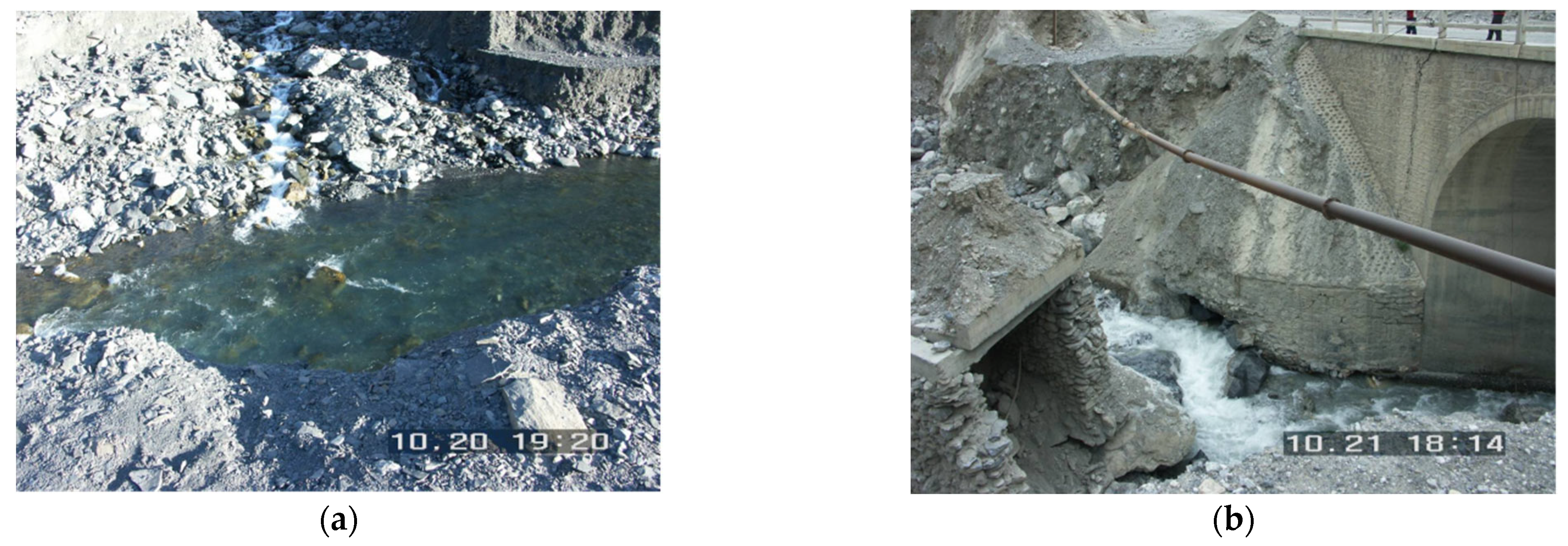
2.1. Overview of Debris Flows along the Karakoram Highway

Debris flow is a common natural disaster that occurs in mountainous areas. Except for Antarctica, debris flow disasters are widely developed in the mountainous areas of the other six continents, with typical characteristics such as sudden outbreaks, ferocious onsets, and strong hazards. It can cause heavy casualties and huge property losses to the disaster-affected areas [12,13,14]. Among the geological disasters developed along the Karakoram Highway, debris flow is the most common and most harmful type of geological disaster. The concept of sustainable development of debris flow requires long-term, comprehensive, and coordinated measures to balance the relationship between debris flow disaster prevention and social and economic development. It includes reducing the occurrence and impact of the debris flows while considering the needs and sustainability of social and economic development. Additionally, it involves addressing issues such as ecological environment protection and cultural heritage preservation. The research team organized four large-scale field investigations on the Karakoram Highway and found that there are more than 140 debris flows in the area from Raikot (K470+500) to Khunjerab (K811), causing serious damage to the road (Figure 1), such as blocking the flow of rivers into lakes, flooding roads, burying and destroying road surfaces, cutting embankments, silting bridges and culverts, and impacting bridge and culvert foundations [14,15].
According to the previous research results of the team, from south to north, there are four types of debris flow disasters on the Karakoram Highway: the rain type, the rain glacier type, the glacier ice lake break type, and the freeze–thaw type [9,16]. The specific distribution is shown in Table 1.

2.2. Obtaining the Basic Data of Debris Flow Gully Slope and Provenance Particle Characteristics

The basic data on the four types of debris flow gully slope and provenance particle characteristics that developed along the Karakoram Highway were obtained by combining field measurement and indoor statistical analysis. Combining field measurements provides support for the accuracy and reliability of the research, while indoor statistics provide reference and help for the debris flow provenance particle characteristics [17]. The slope of the debris flow gully is measured using Laser Craft, a laser rangefinder imported from the United States, with an accuracy of 0.1 degrees. For some segmented debris flow gully, the slope of each segment is measured first, and then, the slope of the whole gully is calculated by the weighted average method. From the field investigation of the Karakoram Highway, it can be seen that most of the source particles distributed in the debris flow gully are in the shape of a cuboid, with particle size parameters in three directions: length, width, and height. Therefore, firstly, the most distributed provenance particles in each debris flow gully are selected as the average particle sample in the gully, and their size is measured in the three directions of length, width, and height with a tape with an accuracy of millimeters, and the average particle size of the debris flow provenance is obtained. Then, the equivalent volume diameter method (defined as the diameter of the ball with the same volume as the actual particle) in the equivalent particle size theory is adopted. The purpose is to convert average particle size into average particle equivalent particle size parameter to express its provenance particle characteristics [18]. In this study, for the convenience of expression, the debris flow gully slope is expressed by α , and the provenance average particle equivalent diameter is expressed by D .
The method for determining the provenance average particle equivalent diameter of the debris flow on the Karakoram Highway is as follows:
(1)
Assuming that the average particle size in the three directions of length, width, and height of the debris flow source are a , b , and c , respectively. The equivalent volume diameter method can be used to obtain:
a b c = 4 3 π ( D 2 ) 3 ,
(2)
The provenance average particle equivalent diameter of the debris flow along the Karakoram Highway can be obtained as D :
D = 6 a b c π 3 ,
The basic data of gully slope and the provenance particle characteristics of four types of debris flow disasters developed along the Karakoram Highway obtained by the above method are shown in Table 2.

3. Results and Discussion

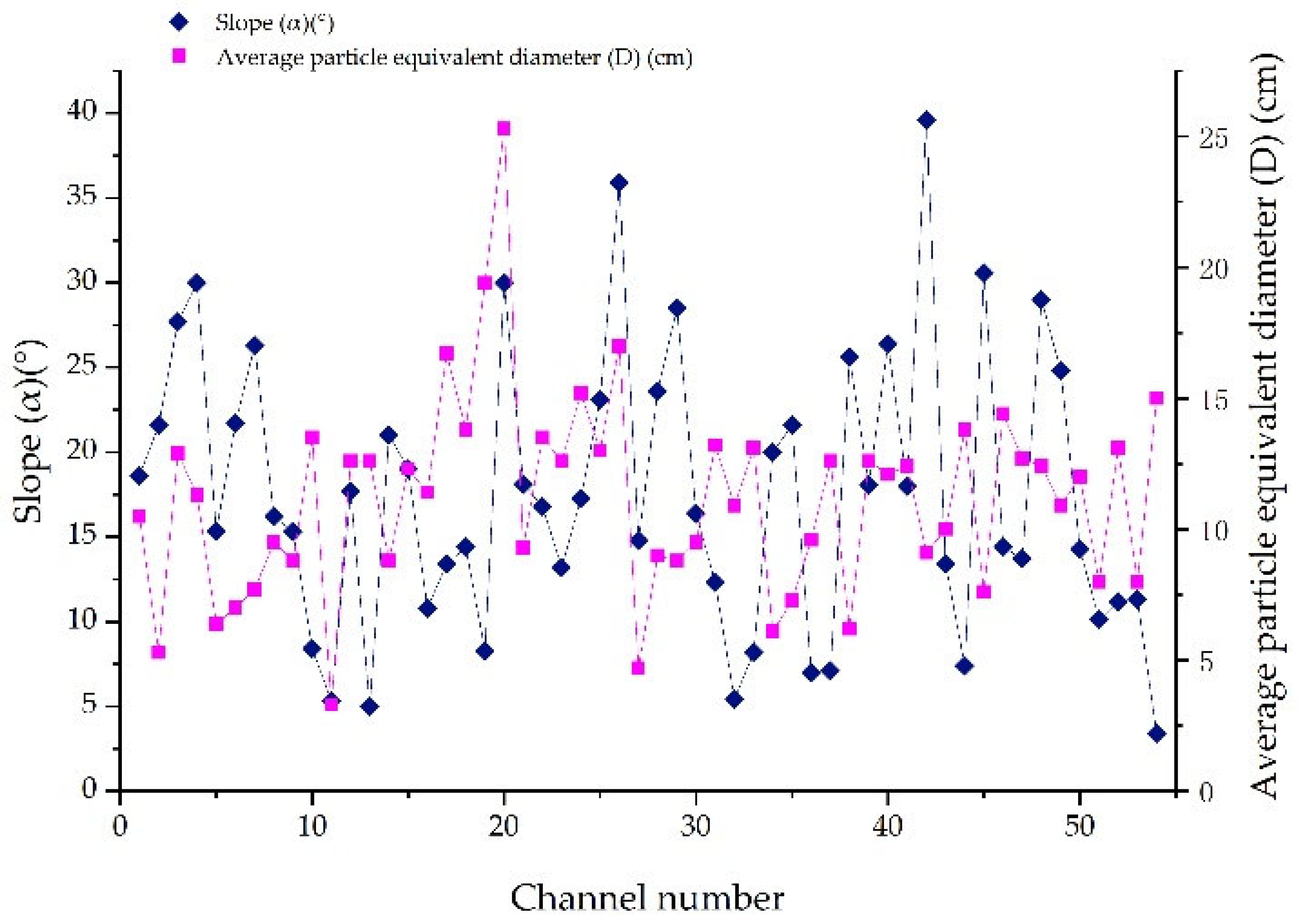
3.1. Variation Law of Debris Flow Provenance Particle Characteristics along the Karakoram Highway

Figure 2 displays the distribution law of the provenance average particle equivalent diameter of the four types of debris flows developed along the Karakoram Highway, as identified in Table 2. The analysis of these data can help us better understand the provenance characteristics of different types of debris flows.
According to the analysis in Figure 2, the provenance average particle equivalent diameter of the rain type debris flows developed along the Karakoram Highway is between 5 and 20 cm. The provenance average particle equivalent diameter of the rain glacier type debris flows mainly varies from 3 to 15 cm. The provenance average particle equivalent diameter of the glacier ice lake break type debris flows is mainly distributed in the range of 2 to 10 cm. The provenance average particle equivalent diameter of the freeze–thaw type debris flows fluctuates between 5 and 15 cm. It can be seen that the provenance average particle equivalent diameter causing debris flow disasters on the Karakoram Highway is controlled by the type of debris flow. Generally, the provenance average particle equivalent diameter of the glacier ice lake break type debris flow is relatively small, followed by the freeze–thaw type debris flow, the rain glacier type debris flow, and the rain type debris flow is relatively large.
The difference between the average particle equivalent diameters of the four types of debris flows along the Karakoram Highway is mainly determined by the basic environmental conditions of their respective regions, such as climate, physical weathering, and ice and snow freezing and thawing. The specific reasons are as follows:
(1)
The area where the rain type debris flow is developed is located in the subtropical climate zone, with high temperature but a small temperature difference, weak physical weathering, and ice and snow freezing and thawing, so the damaging effect on rock and soil particles is relatively small, and the provenance average particle equivalent diameter is relatively large;
(2)
The distribution area of the glacier ice lake break type debris flow belongs to the typical inland plateau mountain climate, with small precipitation, thin air, strong solar radiation, low temperature and very large temperature difference, and strong physical weathering, and ice and snow freezing and thawing. At the same time, they are mainly started by glaciers, and there is strong friction between glaciers and particles, which has a strong destructive effect on rock and soil particles, so the provenance average particle equivalent diameter is small;
(3)
The distribution area of the rain glacier type debris flow lies between the areas where rain type debris flow and glacier ice lake break type debris flow develop. The weather, physical weathering, and the ice and snow freezing and thawing effects of this type of debris flow are also intermediate between the two types. As a result, the provenance average particle equivalent diameter of this type of debris flow is between the other two types of debris flow. Analyzing these characteristics can help us better understand the differences and features of different types of debris flow, and develop effective prevention and response measures;
(4)
The freeze–thaw type debris flow is mainly distributed in the section of the Karakoram Highway at an altitude of more than 4000 m. On the one hand, this section belongs to a typical alpine permafrost area, with thick permafrost depth, low temperature and large temperature difference, strong physical weathering, and ice and snow freeze–thaw effect. On the other hand, its surface material is mainly fine sandy soil with rich clay particles, and the larger particles are almost completely wrapped by the surface fine sandy soil. It weakens the damage of physical weathering and ice and snow freezing and thawing on these rocks and soils, so the provenance average particle equivalent diameter of the freeze–thaw debris flow in this section is relatively large, which also explains why the variation trend of the average particle size of the freeze–thaw debris flow source developed on the Karakoram Highway is larger than that of the glacier ice lake break type debris flow.

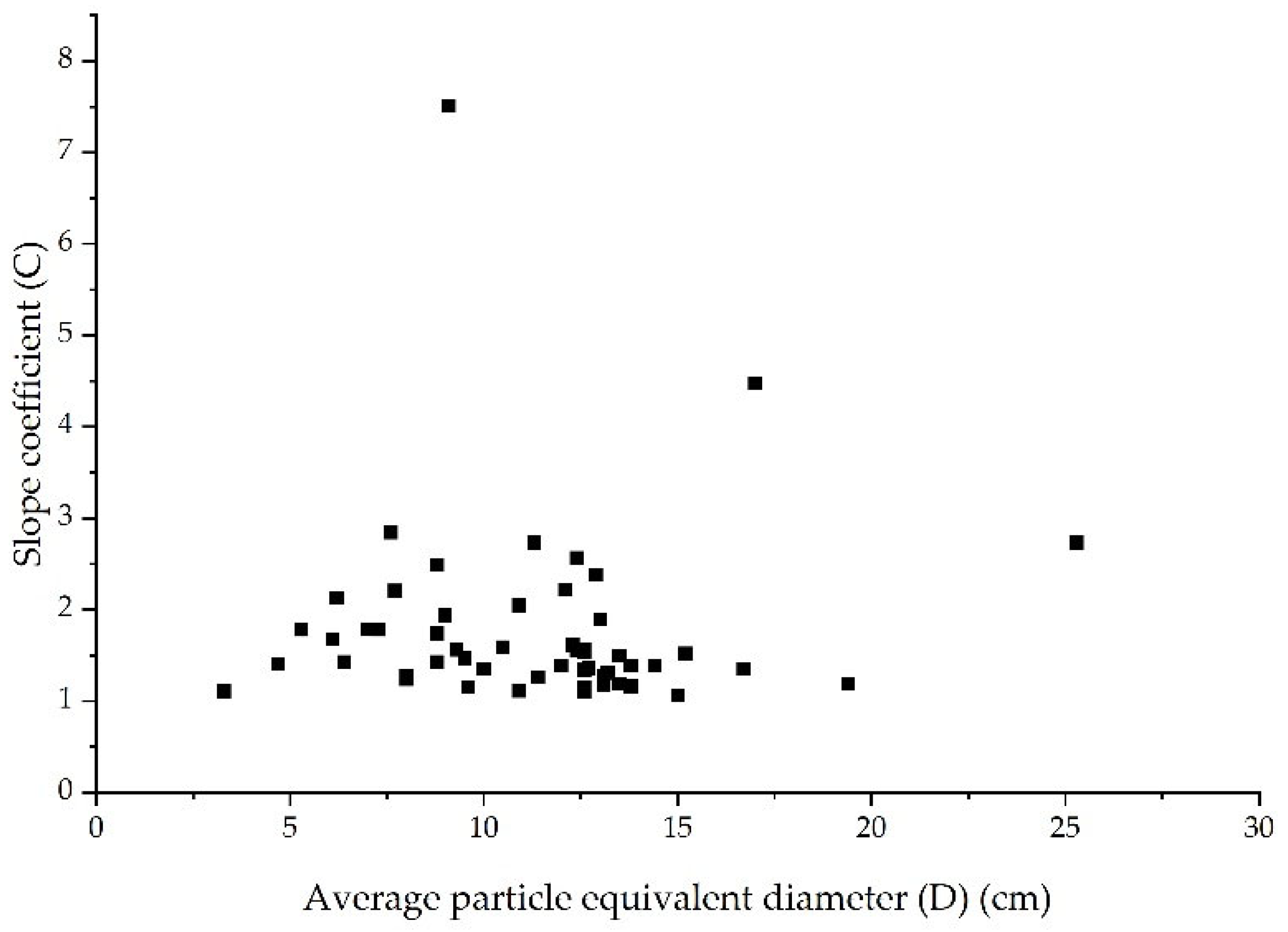
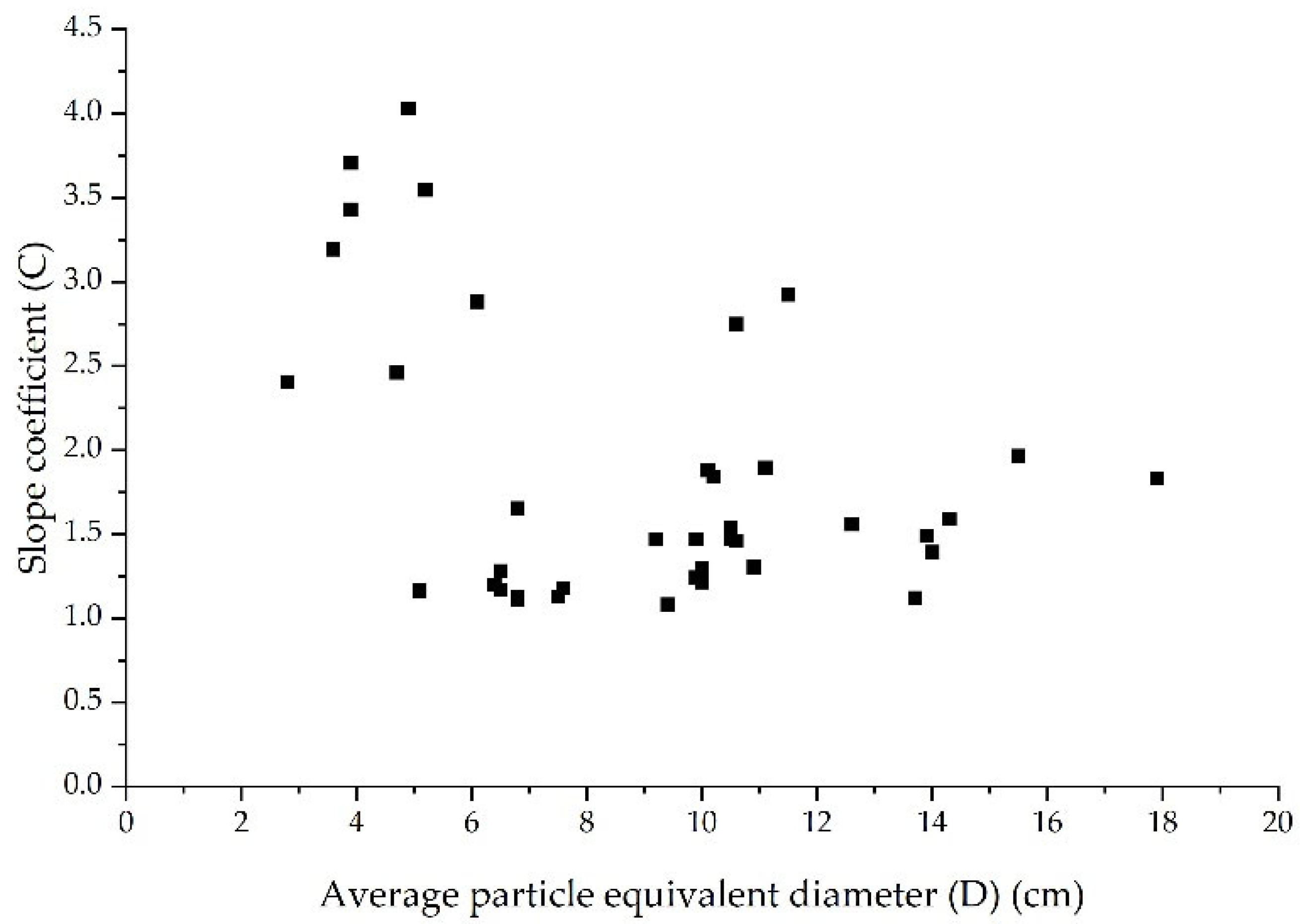
3.2. Relationship between Particle Characteristics of Debris Flow Source, Gully Slope, and Debris Flow Type

To study the quantitative relationship between the slopes ( α ) of four types of debris flow gully developed along the Karakoram Highway and their corresponding average particle equivalent diameters ( D ), the gully slope coefficient ( C ) is defined as follows:
C = 1 cos α sin a
As seen in Table 2, the slope of debris flow gullies distributed along the Karakoram Highway is in the range of 0° to 45° (excluding 0° and 45°). According to the analysis of Equation (3), the slope coefficient ( C ) of these debris flows is greater than 1 and increases with the increase in the gully slope ( α ), that is, the greater the slope coefficient ( C ), the steeper the slope.

3.2.1. Rain Type Debris Flow

The slope of the rain type debris flow gully developed along the Karakoram Highway is mainly distributed in the range of 5° to 30°, and the average particle equivalent diameter is between 5 and 20 cm. The relationship between the two is shown in Figure 3.
The relationship between the slope coefficient ( C ) of rain type debris flow gully and its corresponding average particle equivalent diameter ( D ) is shown in Figure 4.
According to the analysis in Figure 4, about 95% of the slope coefficient ( C ) and the average particle equivalent diameter ( D ) of the source of rain type debris flow are distributed in an ellipse with the two as the axis, which can be expressed as:
( D 11 ) 2 9 2 + ( C 1 ) 2 2 2 1

3.2.2. Rain Glacier Type Debris Flows

The slope of the rain glacier type debris flow gully is an important factor affecting its occurrence and development. Based on research, it has been found that the slope of this type of gully is mostly distributed in the range of 5°to 35°. Additionally, the average particle equivalent diameter of the debris flow’s provenance is another important characteristic, and it is mainly distributed in the range of 3 to 15 cm. The relationship between the slope and the average particle equivalent diameter of the gully is shown in Figure 5.
The relationship between the slope coefficient ( C ) and the average particle equivalent diameter ( D ) of the rain glacier type debris flow gully is a key factor in understanding the characteristics and behavior of this type of debris flow. The relationship between these two parameters is shown in Figure 6, where it can be observed that there is a correlation between the slope coefficient and the average particle equivalent diameter.
Similarly, it can be concluded that the gully slope coefficient ( C ) and the corresponding average particle equivalent diameter ( D ) of most rain glacier type debris flows are also distributed in an ellipse with the two as the axis, and the specific expression of the ellipse is
( D 10 ) 2 9 2 + ( C 2 ) 2 1 2 1

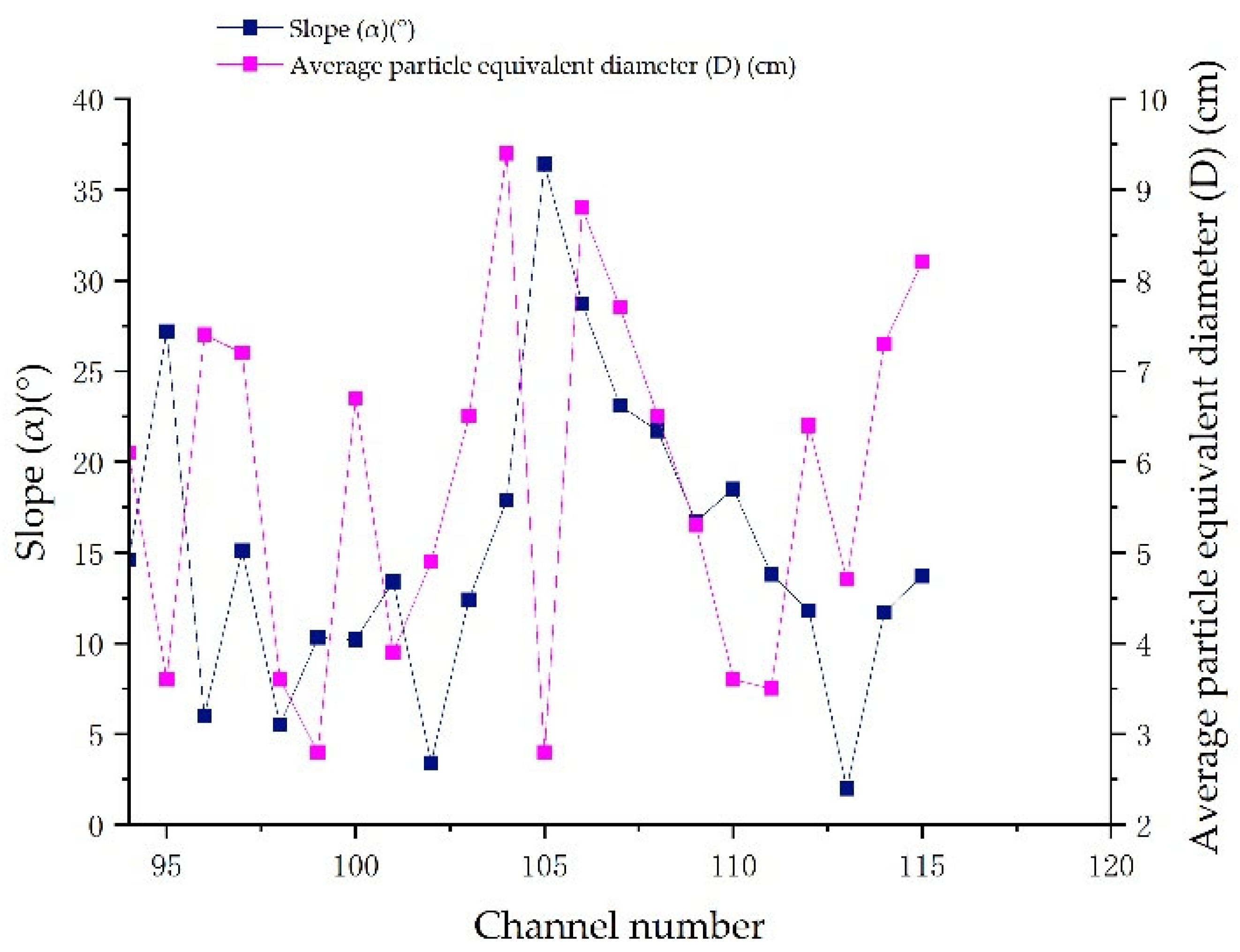
3.2.3. Glacier Ice Lake Break Type Debris Flows

The slope of the glacier ice lake break type debris flow gully and the average particle equivalent diameter of the debris flow are two important factors that influence the occurrence and development of this type of debris flow. The slope of the gully fluctuates mainly in the range of 5° to 30°, while the average particle equivalent diameter of the debris flow is mainly between 2 and 10 cm. The relationship between these two parameters is shown in Figure 7. This relationship can be used to predict the potential occurrence and severity of glacier ice lake break type debris flows in different gully slopes and particle sizes.
The relationship between the slope coefficient ( C ) of the glacier ice lake type debris flows gully and its corresponding average particle equivalent diameter ( D ) is shown in Figure 8.
Similarly, as seen in Figure 8, the relationship between the slope coefficient ( C ) and the corresponding average particle equivalent diameter ( D ) of more than 95% of the glacier ice lake break type debris flows gully is also elliptic, and its specific expression is
( D 5.5 ) 2 ( 4.5 ) 2 + ( C 2 ) 2 1 2 1

3.2.4. Freeze–Thaw Type Debris Flows

The slope of the freeze–thaw type debris flows gully is mainly distributed in the range of 5° to 20°, and the average particle equivalent diameter fluctuates between 5 and 15 cm. The relationship between them is shown in Figure 9.
The relationship between the slope coefficient ( C ) of freeze–thaw type debris flows gully and the average particle equivalent diameter ( D ) is shown in Figure 10.
It can also be seen in Figure 10 that most of the slope coefficient ( C ) of the freeze–thaw type debris flows and the provenance average particle equivalent diameter ( D ) are also distributed in the ellipse with the two as the axis, and the relationship is
( D 12.5 ) 2 ( 7.5 ) 2 + ( C 1.5 ) 2 ( 0.5 ) 2 1
To sum up, the relationship between the gully slope coefficient and the average particle equivalent diameter of the four types of debris flow disasters (rain, rain glacier, glacier ice lake break, and freeze–thaw) developed along the Karakoram Highway can be expressed as an ellipse with both parameters as the axis. The elliptic expressions provide a quantitative representation of the changing relationship between the gully slope and the corresponding source particle characteristics of these debris flow events. The analysis of this relationship can aid in predicting the occurrence and severity of these events and designing effective prevention and control measures. Understanding the interplay between the gully slope and source particle characteristics is crucial in mitigating the damage caused by debris flow disasters along the Karakoram Highway.

3.3. Thoughts and Suggestions on Debris Flow Disasters

Through the study of the gully slope coefficient and the equivalent particle size distribution of the source average particle size of the rain type, the rain glacier type, the glacier ice lake break type, and the freeze–thaw type, ecological engineering, and civil engineering measures are carried out to control debris flow in different sections of the Karakoram Highway.
The ecological engineering measures are mainly to close the mountains along the Karakoram Highway for afforestation and plant vegetation to weaken the physical weathering, ice and snow freeze–thaw damage to these rock and soil bodies, and at the same time, block the water flow to form channels.
Civil engineering prevention and control measures aim to build slope protection and retain the walls in accordance with to the equivalent particle size of the source average particles, thereby strengthening the rock mass and weakening the damage of the external environment to the rock mass particles. According to the relationship between the slope coefficient of the channel and the equivalent particle size of the source average particle, the drainage project is constructed, adjusting and diverting debris flow circulation paths and silting sites. Based on the principle that the source of matter dominates the formation of debris flow, the channel debris flow control technology of ‘mainly draining and blocking large and small ones’ is an effective scientific prevention and control method. The research on the types of debris flow and taking corresponding prevention and control measures provides theoretical support and suggestions for sustainable governance.
During the process of highway construction, monitoring points are constructed in each section to build a spatial-temporal data model of ground substrate. To carry out layer current situation, development and utilization degree and potential analysis, forecast changes and development trend, and comprehensively analyze the overall situation of high-quality development of natural resources, ecological environment and regions. Elevation models and digital surface models can be established as the basis, and the idea of establishing a 2D and 3D integrated database can be established as the goal, and the space–time model can be bound to the survey attributes so that all data can be merged in the form of a database. In the process of implementation, it is necessary to strengthen analysis and evaluation, collect statistics, summarize the survey, monitor the data of the surface matrix layer, establish scientific evaluation indicators, carry out comprehensive analysis and systematic evaluation to provide a basis for scientific decision-making and strict management, and improve the sustainable development of the surrounding ecological environment and the sustainable use of the Karakoram Highway.

4. Conclusions

This paper draws several important conclusions. The characteristics of debris flow disasters vary significantly depending on their source and origin. The relationship between the gully slope and average particle equivalent diameter of the debris flow can be represented by an ellipse. The specific conclusions are as follows:
  • The provenance particle size induced by debris flow on the Karakoram Highway is controlled by the type of debris flow. Generally, the provenance average particle equivalent diameter of the glacier ice lake break debris flow is relatively small, followed by the freeze–thaw and rain glacier debris flow, and the rain type debris flow is relatively large;
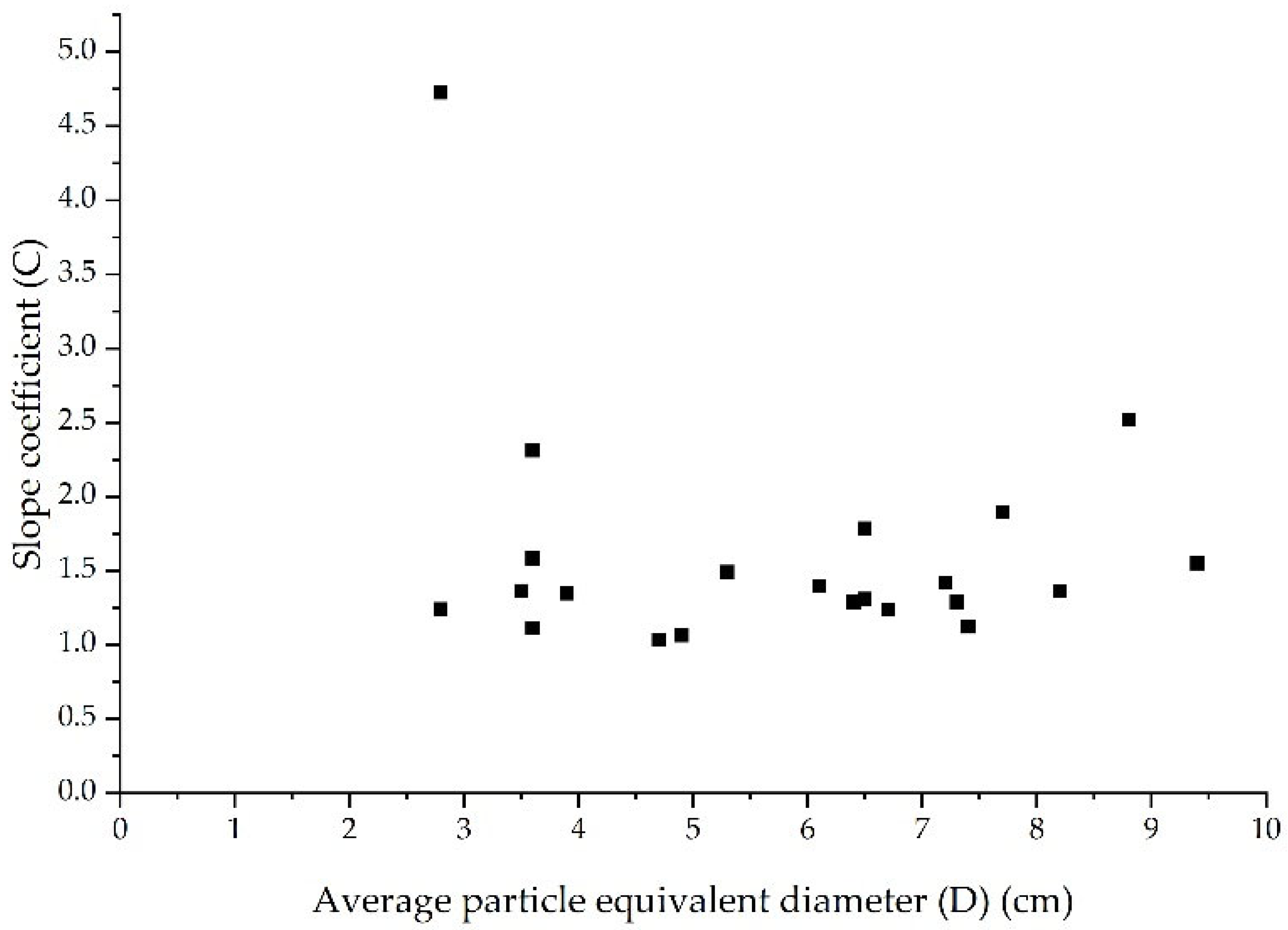
  • This analysis shows that the slope coefficient of debris flow gullies along the Karakoram Highway is greater than 1, and it increases as the gully slope becomes steeper. In other words, gullies with higher slope coefficients have steeper slopes;
  • The majority of debris flows that occur along the Karakoram Highway can be categorized into four types: rain type debris flows, rain glacier type debris flows, glacier ice lake break type debris flows and freeze–thaw type debris flows. These types of debris flows are characterized by their gully slope coefficient C and the provenance average particle equivalent diameter D , which are distributed in an elliptical patterns. By analyzing these ellipses, we can better understand the relationship between the gully slope of each type of debris flow and the corresponding provenance particle characteristics.

Author Contributions

Conceptualization, J.Z.; Methodology, N.H.; Data curation, L.W.; Formal analysis, H.X.; Investigation, Z.Y.; Writing—original draft, Z.Y.; Writing—review and editing, Y.L. All authors have read and agreed to the published version of the manuscript.

Funding

This research was funded by the National Natural Science Foundation of China (Grant No. 41861134008), the Muhammad Asif Khan academician workstation of Yunnan Province (Grant No. 202105AF150076), the Key R&D Program of Yunnan Province (Grant No. 202003AC100002), the General Program of basic research plan of Yunnan Province (Grant No. 202001AT070043), the Science and Technology Talents and Platform Program of Yunnan Province (Grant No. 202305AD160064), and the Basic Research Project of Yunnan Province (Grant No. 202201AT070283).

Data Availability Statement

Data are contained within the article.

Conflicts of Interest

The authors declare no conflict of interest.

References

  1. John, M. Karakoram Highway; Lonely Planet: Melbourne, VIC, Australia, 1998; pp. 10–25. [Google Scholar]
  2. John, M. Trek in Karakoram and Hindu Kush; Lonely Planet: Melbourne, VIC, Australia, 2002; pp. 5–6. [Google Scholar]
  3. Star Island Global Network. Karakoram Highway Is About to be Rebuilt and Expanded. Available online: https://web.archive.org/web/20080911030508/http://www.singtaonet.com/global/global_sp/t20060417_192420.html (accessed on 9 February 2023).
  4. Multidimensional News. Expending 500 Million Yuan to Expand the China-Pakistan Friendship Road: Only Chinese People Can Do It. Available online: https://web.archive.org/web/20220311222845/http://ww5.chinesenewsnet.com/ (accessed on 9 February 2023).
  5. Ding, M.H.; Huai, B.J.; Sun, W.J.; Wang, Y.T.; Zhang, D.Q.; Guo, X.Y.; Zhang, T. Surge-type glaciers in Karakoram Mountain and possible catastrophes alongside a portion of the Karakoram Highway. Nat. Hazards 2018, 90, 1017–1020. [Google Scholar] [CrossRef]
  6. CCCC First Highway Survey and Design Institute. Design Specification for Construction Drawings of Karakoram Highway Reconstruction Project (Lekote-Hongqilapu Section); CCCC First Highway Survey and Design Institute: Beijing, China, 2008; p. 59. [Google Scholar]
  7. Jiangsu Institute of Seismic Engineering. Report on Seismic Safety Assessment of the Reconstruction Project Site of Pakistan Karakoram Highway (Lekot to Hongqilapu Section); Jiangsu Institute of Seismic Engineering: Beijing, China, 2006; p. 5. [Google Scholar]
  8. Zhu, Y.Y.; Pan, J.Y.; Li, C.Y.; Yang, Z.Q.; Liao, L.P.; Muhammad, W. Glacier debris flow along China-Pakistan International Karakoram Highway (KKH). Mt. Res. 2022, 40, 71–83. [Google Scholar]
  9. Zhu, Y.Y.; Li, C.Y.; Yang, Z.Q.; Liao, L.Y.; Waseem, M.; Luo, Z. Glacier Lake Outburst Flood (GLOF) along China-Pakistan International Karakoram Highway (KKH). Mt. Res. 2021, 39, 524–538. [Google Scholar]
  10. Zhu, Y.Y.; Yang, Z.Q.; Liao, L.Y.; Steve, Z.; Muhammad, W.; Ye, C.Y.; Chen, H.P.; Pang, M. Glacialized geomorphologcial geohazard along China-Pakistan International Karakoram Highway. J. Catastrophol. 2014, 29, 81–90. [Google Scholar]
  11. Zhu, Y.Y.; Yang, Z.Q.; Zou, S.; Waseem, M.; Ye, C.Y.; Pang, M. Glacier geohazards along China-Pakistan International Karakoram Highway. J. Highw. Transp. Res. Dev. 2014, 31, 51–59. [Google Scholar]
  12. Liu, Z.Q.; Yang, Z.Q.; Chen, M.; Xu, H.H.; Yang, Y.; Zhang, J.; Wu, Q.; Wang, M.M.; Song, Z.; Ding, F.S. Research hotspots and frontiers of mountain flood disaster: Bibliometric and visual analysis. Water 2023, 15, 673. [Google Scholar] [CrossRef]
  13. Yang, Z.Q.; Zhao, X.G.; Chen, M.; Zhang, J.; Yang, Y.; Chen, W.T.; Bai, X.F.; Wang, M.M.; Wu, Q. Characteristics, dynamic analyses and hazard assessment of debris flows in Niumiangou Valley of Wenchuan County. Appl. Sci. 2023, 13, 1161. [Google Scholar] [CrossRef]
  14. Liao, L.P.; Zhu, Y.Y.; Yang, Z.Q.; Muhammad, W.; Steve, Z.; Chen, J.D.; Wang, Y.; Ye, C.Y.; Zhang, X.J. Debris flow hazards and prevention optimization along International Karakoram Highway. Geol. Sci. Technol. Inf. 2013, 32, 168–174. [Google Scholar]
  15. Yang, Z.Q.; Zhu, Y.Y.; Qian, S.G.; Hou, K.P. Types and space distribution characteristics of debris flow disasters along China-Pakistan highway. Electron. J. Geotech. Eng. 2016, 21, 191–200. [Google Scholar]
  16. Chengdu Institute of Mountain Hazards and Environment, Ministry of Water Resources, Chinese Academy of Sciences. Investigation Report on Geological Hazards of KKH Highway in 2009; Chengdu Institute of Mountain Hazards and Environment, Ministry of Water Resources, Chinese Academy of Sciences: Chengdu, China, 2009; p. 23. [Google Scholar]
  17. Li, X.S.; Peng, J.; Xie, Y.L.; Li, Q.H.; Zhou, T.; Wang, J.W.; Zheng, W. Influence of high-temperature treatment on strength and failure behaviors of a quartz-rich sandstone under true triaxial condition. Lithosphere 2022, 2022, 3086647. [Google Scholar] [CrossRef]
  18. Li, T.; Zhou, Y.C.; Zhu, J.; Liu, J.P. Effect of fine aggregate gradation on the rheology of mortar. Constr. Build. Mater. 2022, 332, 127362. [Google Scholar] [CrossRef]
Figure 1. (a) K770+600 debris flow cutting embankment; (b) K707+730 debris flow impacting bridge and culvert foundation.
Sustainability 15 05998 g001
Figure 2. Distribution law of provenance average particle equivalent diameter of four types of debris flows developed along the Karakoram Highway.
Sustainability 15 05998 g002
Figure 3. Variation relationship between gully slope and average particle equivalent diameter of rain type debris flow.
Sustainability 15 05998 g003
Figure 4. Relationship between slope coefficient of rain type debris flow gully and average particle equivalent diameter.
Sustainability 15 05998 g004
Figure 5. Variation relationship between gully slope and average particle equivalent diameter of rain glacier type debris flows.
Sustainability 15 05998 g005
Figure 6. Relationship between slope coefficient of rain glacier type debris flows gully and average particle equivalent diameter.
Sustainability 15 05998 g006
Figure 7. Variation relationship between gully slope and average particle equivalent diameter of glacier ice lake break type debris flows.
Sustainability 15 05998 g007
Figure 8. Relationship between slope coefficient of glacier ice lake type debris flows gully and average particle equivalent diameter.
Sustainability 15 05998 g008
Figure 9. Variation relationship between gully slope and average particle equivalent diameter of freeze–thaw type debris flows.
Sustainability 15 05998 g009
Figure 10. Relationship between gully slope coefficient of freeze–thaw type debris flows and the average particle equivalent diameter.
Sustainability 15 05998 g010
Table 1. Distribution of four types of debris flow disasters along the Karakoram Highway [9,16].
Debris Flow TypeDistribution Interval
Rain type debris flowDistributed between Raikot (K470+500) and Daynore (K538)
Rain glacier type debris flowLocated between Daynore (K538) and Hasnabard (K623)
Glacier ice lake break type debris flowDistributed between Hasnabard (K623) and Gosghil (K796)
Freeze–thaw type debris flowLocated between Gosghil (K796) and Khongjirap (K811)
Table 2. Basic data of four types of debris flow disasters developed along the Karakoram Highway.
Debris Flow TypeChannel
Number
Highway Stake NumberSlope (α)
(°)
Average Particle Size
(cm × cm × cm)
Average Particle Equivalent Diameter ( D ) (cm)
Rain type debris flows1K471+86018.612 × 10 × 510.5
2K473+52121.65 × 8 × 25.3
3K475+27027.716 × 10 × 712.9
4K475+950-K476+125.3308 × 13 × 711.3
5k477+89615.35 × 9 × 36.4
6K477+38021.79 × 10 × 27.0
7K478+25026.36 × 10 × 47.7
8K479+84016.210 × 9 × 59.5
9K480+036.115.315 × 6 × 48.8
10K481+525-K481+5508.413 × 14 × 713.5
11K483+41-K483+4685.33 × 1.5 × 43.3
12K486+67017.710 × 13 × 812.6
13K489+700-740515 × 7 × 1012.6
14K490+0502112 × 5 × 68.8
15K490+2251913 × 15 × 512.3
16K491+70-k491+90010.816 × 7 × 711.4
17K493+692-71013.413 × 17 × 1116.7
18K494+15-K494+18514.414 × 11 × 913.8
19K496+6508.313 × 14 × 2119.4
20K496+8203031 × 21 × 1325.3
21K503+723.518.113 × 8 × 49.3
22K504+731-77216.811 × 13 × 913.5
23K504+860-87213.29 × 13 × 912.6
24K505+09017.317 × 12 × 915.2
25K505+36723.116 × 6 × 1213.0
26K506+10035.920 × 16 × 817.0
27K506+68314.811 × 5 × 14.7
28K508+35523.611 × 7 × 59.0
29K508+57728.59 × 8 × 58.8
30K508+865.816.415 × 10 × 39.5
31K512+98012.38 × 10 × 1513.2
32K515+3405.416 × 7 × 610.9
33
34
35
K518+830-
K519+000
No.1 ditch8.214 × 7 × 1213.1
No.2 ditch205 × 6 × 46.1
No.3 ditch21.611 × 6 × 37.27
36K519+24476 × 6 × 139.6
37K519+3807.113 × 8 × 1012.6
38K519+65125.63.5 × 7 × 56.2
39K519+86018.112 × 11 × 812.6
40K520+200-22026.411 × 12 × 712.1
41K520+5201811 × 13 × 712.4
42K521+95039.619 × 7 × 39.1
43K524+10013.413 × 10 × 410.0
44K524+9607.411 × 14 × 913.8
45K525+860-87530.613 × 9 × 27.6
46K524+10314.413 × 20 × 614.4
47K526+94013.712 × 10 × 912.7
48K527+3002915 × 11 × 612.4
49K528+74024.88 × 14 × 610.9
50K529+67014.312 × 15 × 512.0
51K530+53510.19 × 10 × 38.0
52K530+66011.214 × 17 × 513.1
53K531+90011.311 × 6 × 48.0
54K535+650-K536+0003.416 × 11 × 1015.0
Rain glacier type debris flows55K543+210-2804.218 × 4 × 69.4
56K547+30022.411 × 10 × 510.2
57K547+52418.617 × 18 × 514.3
58K548+00012.213 × 13 × 410.9
59K549+00023.915 × 13 × 1015.5
60K549+30010.39 × 14 × 49.9
61K549+42019.77 × 8 × 36.8
62K549+60530.19 × 10 × 710.6
63K549+80514.511 × 12 × 1114.0
64K550+198.516.310 × 10 × 610.5
65K550+89123.118 × 10 × 411.1
66K551+32711.913 × 10 × 410.0
67K551+67117.612 × 10 × 510.5
68K551+86222.320 × 15 × 1017.9
69K556+10066 × 9 × 36.8
70K555+8685.47 × 8 × 36.8
71K557+5408.26 × 13 × 37.6
72K559+4005.915 × 9 × 1013.7
73K560+9003111 × 9 × 811.5
74K562+50030.85 × 8 × 36.1
75K566+8606.24 × 7 × 87.5
76K569+5709.46 × 11 × 810.0
77K570+94016.29 × 9 × 59.2
78K576+300167 × 18 × 510.6
79K578+839-852.632.24 × 6 × 13.6
80K579+87416.710 × 20 × 713.9
81K581+60027.91 × 3 × 42.8
82K586+30028.34 × 7 × 24.7
83K592+92022.918 × 10 × 310.1
84K593+46516.315 × 17 × 29.9
85K594+4007.65 × 7 × 25.1
86K597+8797.88 × 6 × 36.5
87K599+5858.95 × 7 × 46.4
88K604+0601815 × 10 × 712.6
89K607+96011.56 × 3 × 86.5
90K614+92133.55 × 5 × 35.2
91K615+50934.96 × 5 × 24.9
92K615+83533.12 × 5 × 33.9
93K615+930345 × 3 × 23.9
Glacier ice lake break type debris flows94K62814.65 × 6 × 46.1
95K653+96527.22 × 3 × 43.6
96K687+44067 × 6 × 57.4
97K705+680-72015.18 × 8 × 37.2
98K709+1805.54 × 3 × 23.6
99K711+70010.33 × 2 × 22.8
100K715+654-67410.25 × 8 × 46.7
101K716+290-32013.42 × 3 × 53.9
102K717+4083.43 × 7 × 34.9
103K723+91512.48 × 9 × 26.5
104K732+20017.99 × 12 × 49.4
105K744+20036.43 × 1 × 42.8
106K747+17028.715 × 4 × 68.8
107K741+75523.110 × 12 × 27.7
108K756+10021.78 × 6 × 36.5
109K763+75016.75 × 8 × 25.3
110K766+60018.54 × 6 × 13.6
111K771+725-90013.811 × 1 × 23.5
112K773+50011.810 × 7 × 26.4
113K776+3882.07 × 2 × 44.7
114K784+90011.710 × 10 × 27.3
115K785+76013.712 × 6 × 48.2
Freeze–thaw type debris flows116K801+0602120 × 12 × 815.4
117K802+04816.512 × 7 × 810.9
118K802+22513.625 × 15 × 1019.3
119K802+40015.816 × 8 × 812.5
120K803+58815.16 × 9 × 36.8
121K806+60016.95 × 7 × 25.1
122K8114.515 × 8 × 1314.4
Disclaimer/Publisher’s Note: The statements, opinions and data contained in all publications are solely those of the individual author(s) and contributor(s) and not of MDPI and/or the editor(s). MDPI and/or the editor(s) disclaim responsibility for any injury to people or property resulting from any ideas, methods, instructions or products referred to in the content.

