Article

Geomorphological Heritage in Viñales National Park (Aspiring UNESCO Geopark): Geomatic Tools Applied to Geotourism in Pinar del Río, Cuba

by
José Luis Goy
1,
Jose Luis Corvea
2,
Irene de Bustamante
3,4,
Antonio Miguel Martínez-Graña
1,*,
Carlos Díaz-Guanche
5,
Caridad Zazo
6,
Cristino J. Dabrio
7,
José Ángel González-Delgado
1,
Alberto Blanco
4 and
Carlos E. Nieto
1
1
Departamento de Geología, Facultad de Ciencias, Universidad de Salamanca, Plaza Merced s/n, 37008 Salamanca, Spain
2
Consultora Ambiental Inversiones GAMMA SA, C/ 2, nº 124 e/ 1ra y 3ra Miramar, Playa, La Habana C.P. 11300, Cuba
3
Departamento de Geología, Edificio Ciencias, Universidad de Alcalá, 28871 Alcalá de Henares, Spain
4
IMDEA Agua, Avenida Punto Con, nº 2 Parque Científico Tecnológico de la Universidad de Alcalá, 28805 Madrid, Spain
5
Departamento de Geología, Universidad de Pinar del Río, Martí Final, Pinar del Río C.P. 20100, Cuba
6
Museo Nacional de Ciencias Naturales, Sección Geología, Calle José Gutiérrez Abascal nº 2, 28006 Madrid, Spain
7
Departamento de Geodinámica, Estratigrafía y Paleontología, Faculty of Geology, Universidad Complutense, 28840 Madrid, Spain
*
Author to whom correspondence should be addressed.
Sustainability 2023, 15(7), 5704; https://doi.org/10.3390/su15075704
Submission received: 6 January 2023 / Revised: 7 March 2023 / Accepted: 22 March 2023 / Published: 24 March 2023
(This article belongs to the Special Issue GeoHeritage and Geodiversity in the Natural Heritage: Geoparks)

Abstract

:
A detailed analysis of the Viñales National Park (VNP) was carried out to evaluate the main geosites of geomorphological interest inside the park. This allowed the selection of areas (AIG) and localities (LIG) with 20 geosites of geological interest (PIG) suitable to evaluate their importance as geoheritage. Moreover, three field trips and one virtual itinerary encompassing the park aimed to improve the geological–geomorphological knowledge to be used in geotouristic and preservation issues. The methodology included preparing five maps: relief, drainage pattern, slopes, lithology and geomorphology (forms and structures) and representing them on a digital terrain model (DTM) for a better visualisation and selecting the geosites (poljes, valleys and mountain fronts). The evaluation of the selected PIG is based on the criteria proposed by Spanish Institute of Geology and Mining, grouping them in places and areas of interest. The virtual itinerary favour real-time usage of web sites and geoportals. As a result, this paper presents map layers and geomorphological descriptions of the AIG and LIG with the most relevant aspects and valuations of the PIG, AIG and LIG. The PIG reached values between 1050 (Viñales Valley) and 365 (La Jutia Valley). The AIG and LIG ranged between 2190 (Santo Tomás Polje) and 675 (La Cuevita Polje).

1. Introduction

Among all the geological variety (geodiversity) observable in an area, some sites of much greater relevance called geosites can form part of the geological heritage (a set of geological resources with high scientific, educational, tourist and cultural value). There is a broad bibliography about the knowledge, valuation, protection, dissemination and management of geoheritage sites [1,2,3], which also provides opportunities for development in rural areas, mainly through geotourism [4,5]. These ideas served to create the “Geopark” concept in 2000, when four regions of Greece, France, Germany and Spain established the European Geoparks Network [6,7]. In 2015, 195 Member States of UNESCO ratified the creation of the UNESCO Global Geoparks (UGGp), which are “single, unified geographical areas where sites and landscapes of international geological significance are managed with a holistic concept of protection, education and sustainable development” (UNESCO 2023; https://en.unesco.org/global-geoparks, accessed on 2 January 2023). At present, there are 177 UGGp in 46 countries. In Latin America and the Caribbean, there are currently 10 recognised UGGp, and in recent years, reviews of the status of their geodiversity, geoconservation, sustainable development and geotourism have been published [8,9,10].
The Parque Nacional Viñales (VNP, Pinar del Río, NW Cuba) is located on the Guanaguanico range, which is formed by a system of carbonate sierras mountains of Jurassic–Cretaceous age with steep slopes and rounded summits (mogotes) separated by fluvial and/or karstic valleys filled by Quaternary deposits. Additionally, there is also a Jurassic shale unit (San Cayetano formation) that forms the northern and southern shale highs (NSH and SSH, respectively) (Figure 1).
The geological, geomorphological and landscape characteristics of this national park and its proximity to La Havana make it the most relevant in Cuba from a touristic, didactic and scientific point of view. It was selected on 4 November 2021 as the first Cuban Geopark.
Considering that the geomorphological component is the most relevant, the regional study allowed us to distinguish 10 geosites (Figure 2), grouped into 7 AIG and 3 LIG, with a total of 20 sites of geological interest (PIG).
  • Viñales polje (AIG-1) with two sub-areas: AIG-11(PIG-1 Valle de Viñales, PIG-2 Valle del Silencio, PIG-3, Cueva Palmarito), AIG-12 (PIG-4 Valle Dos Hermanas, PIG-5 Mogote Dos Hermanas).
  • San Vicente Polje (AIG-2), with two subareas: north and south. AIG-21 (PIG-6, Puerta de Ancón, PIG-7, Cueva Geda. AIG-22 (PIG-8, Cueva del Indio, PIG-9, Balneario San Vicente).
  • Santo Tomas Polje (AIG-3) (PIG-10, Valle de Santo Tomás, PIG-11, Cueva de Santo Tomás, PIG-12, Límite Cretácico-Paleógeno K/Pg).
  • La Jutía Polje (AIG-4), (PIG-13, Hoyo de Jaruco, PIG-14, Valle de la Jutía).
  • Ancón Polje (AIG-5) (PIG-15, Valle and upwelling (Surgencia) de Ancón, PIG-16, Abra de Ancón),
  • La Cuevita Polje (LIG-1)—(PIG-17, Valle de la Cuevita).
  • Pan de Azúcar Valley (LIG2) (PIG-18, Mogote de Pan de Azúcar, PIG-19, Resolladero Pan de Azúcar) and LIG-3 Boquerón del Infierno—El Sitio (PIG-20).
The inventory of the selected geosites (PIG) and the files to locate and classify these geosites have been presented in previous papers from the present [11] and other authors. The analyses by Corvea and collaborators is relevant [12], which evaluated an inventory of 107 PIG following the criteria of Bruschi and Cendrero [13] and was later completed for the 46 geosites selected for the proposal of the future Viñales Geopark [14,15,16]. The last paper valorised the 57 geosites selected for the final application as the geopark following the methodology of the Spanish Institute of Geology and Mining (IGME) [17], where the scientific, didactic and touristic-recreational interests, as well as vulnerability, were considered. Additional information for some of the geosites comes from Corvea and collaborators [12,18,19,20,21,22,23,24].
The knowledge and characterisation of the 20 most significant PIG allow their integration into the evolutionary framework of the VNP, helping to promote its management and geo-conservation and reinforcing the scientific, didactic and touristic interests through three well-selected divulgation fieldtrips to this exceptional geological heritage site.

Geological and Geomorphological Framework

The basement is made up of strongly folded, weakly metamorphosed Lower Jurassic to Late Eocene rocks.
There are three lithological units: a basal terrigenous, an intermediate carbonate, and an upper olistostromic melange of carbonate and terrigenous rocks [25,26].
Synthetically the lithostratigraphy includes, in ascending order [27]: San Cayetano Formation (Jurassic sandstones, shaly clay conglomerates and argilites); Jagua Formation (Late Jurassic well-stratified limestone, shale and limolite, with abundant marine fossils); Guasasa Formation (Late Jurassic–Early Cretaceous limestones with four members (Mb)): San Vicente (responsible for most typical “Mogotes”), El Americano, Tumbadero, and Tumbitas; Pons Formation (Cretaceous dark coloured micritic limestone.
Moncada Formation (Unconformable calcareous sandstones that enclose the K-T boundary); Ancón Formation (Early Paleocene–Early Eocene) limestone, marlstone and calcareous breccia) and Manacas Formation (Early–Middle Eocene) unconformable, olistostromic breccia with sandstone, limolite, calcarenite, limestone, basalts and serpentinite.
On top of these units, there are Quaternary deposits made up of fluvial boulders, clasts, sand, silts and clay, decalcification clay and lacustrine deposits in depressions.
From a tectonic point of view, the region is affected by overthrusts, which form a tectonic set approximately 5000 m in thickness. Up to four large thrust units are differentiated, forming flake tectonics with direction similar to the calcareous unit (mogotes ranges). There are also faults that involve vertical and horizontal displacements, easily visible in the carbonate and terrigenous deposits.
The relief of the park is formed by several sierras (ranges) and calcareous hills, separated by depressions (poljes and valleys), and the siliciclastic deposits (San Cayetano and Manacas Fms) forming the northern and southern shale hills. It is classified as “Karstic-denudative low hills of the structural-karstified type” [28], generating a faulted conic-type tropical karst (Figure 1 and Figure 3).
From a geomorphological point of view, the various morphogenetic systems originating the forms are represented. The morphostructural and karstic systems are the most characteristic, with a superimposed fluvial system.
The morphogenetic systems were analysed through the geomorphological map superimposed on the digital terrain model (DTM). In this way, the behaviour of the geomorphological processes on the geological materials affected by the structures was studied. The erosion and deposition systems (fluvial, karstic, gravity, morphostructural, paludal and mixed) were represented overlying the geological formations with indication of their lithology (type of substratum).

2. Methods

Areas, places (AIG and LIG) and geosites (PIG) were used to analyse the geosites of the study area. The AIG are areas with ample (in Km2) territory that include relevant geological outcrops and geomorphological forms, proofs of active or fossil geomorphological processes and/or landscape elements reflecting the geological history of the area. The LIG are less extensive areas (up to 1000 m2) that reflect the regional patterns characterizing a given zone. They may include information about materials and their genesis, processes, etc. The PIG (geosites), with extension ranging from 1 to 500 m2, are places where forms or processes of the regional history can be observed and analysed [29]. Several PIG may form a LIG or an AIG. In the same way, several LIG can be integrated in a single AIG.
The methodology by García Cortés and collaborators [30] was used for the valorisation. It consists of assigning values from 0 to 4 to a conjunct of 18 parameters related to representativeness, size, character of the type locality, scientific knowledge of the place, state of conservation, accessibility, conditions of observation, rarity, areal infrastructures, density of population, association with other eco-cultural elements, beauty, potential to carry on divulgation activities, closeness to recreational areas and socio-economic conditions of the surroundings (Table 1, upper part). The data obtained are multiplied by ponderation coefficients for each parameter, depending on the type of value (scientific, didactic and touristic) to be obtained. For a scientific valuation, the ponderation parameters are 30 points for representativeness, 15 points for degree of scientific knowledge of the site and rarity and 10 points for the character of the type locality, state of conservation and geological diversity.
For a didactic valuation, the pondered parameters are the didactic content or usage (20 points), logistic infrastructure (15 points), and representativeness, degree of type locality and conservation stage, among others (5 points). For a tourism valuation, the pondered parameters are beauty or spectacularity (20 points), size and content or divulgation usage of the geosite (15 points), accessibility (10 points), and conditions of observation, logistic infrastructure and density of population (5 points), among others (Table 1, lower part). This methodology was used by the present authors in several previous papers [31,32,33,34] and other’s methodologies were used in different areas [35,36].
The study of geological heritage is based upon previous geomorphological studies [37], with new geo-environmental mapping recording essential geomorphological and geological aspects necessary to obtain enough adequate information concerning the geosites and the areas where they are located (Figure 2). Several 1:50,000 map layers were utilised: 1—geological, including Quaternary formations, 2—lithology, 3—morphotectonics and 4—geomorphology. Auxiliary 1:200,000 maps were also incorporated: 1—location and relief (Figure 1), 2—drainage network and morphostructural units (Figure 3). All these maps were drawn by means of GIS aiming for superposition, which gave a better context for the geosites inside the broader selected areas (7 AIG and 3 LIG).
Based on these data, three fieldtrips and a virtual 3D itinerary were prepared to encompass all the studied geosites. They are based on actual technologies (geoportals, cartographic visors, digital terrain models and so on) aimed to enlarge the knowledge of the geological heritage site, as they allow unloading digital documents, posters, interpretative cross sections, routes and virtual itineraries by means of QR codes suitable for the usual mobile devices (smartphones, tablets, iPods, etc.) brought by the visitors. The implementation of the maps on virtual 3D balloons permits the thematic layers to be superimposed and geo-referenced in free platforms such as Google Earth. This allows us to obtain, manage, analyse and reproduce the digital maps by creating a geodatabase able to enrich a possible infrastructure of spatial data (IDE) suitable to be incorporated into web pages and geoportals of the related administration departments, which can be accessed not only by researchers but by ordinary people as well. A few screen captures of the virtual itinerary created in this research are offered in the figures of this paper. The virtual itinerary will permit a real time individual guide to guide the users to the geosites by means of the GPS of the mobile device [32].

3. Results

3.1. Description of the Selected Areas, Places and Geosites

The first area selected (AIG-1) is the Viñales Polje, which consists of two sectors: AIG-1.1, Viñales Valley, and AIG-1.2, Dos Hermanas Valley (Figure 4). The area was declared a national monument (1979) and a cultural mankind landscape (1999). It is a part of the Viñales National Park (2001) and the Cuban Geopark (2021).

3.1.1. AIG 1. Viñales Polje

Located in the central part of the Guanaguanico range, a prominent feature of this polje is the occurrence of two massive reliefs (mogotes of El Valle and Dos Hermanas) surrounded by Quaternary detrital deposits, mostly decalcification clay, runoff and fluvial sediments of the rivers Novillo (west) and El Tejar–Palmarito (east) that drain the area (Figure 4A:2, 3 and 1, 6). The central hills (mogotes) form the so-called Tumbadero range with elevations 400 m above sea level and 300 above the valley floor. The two hills are separated by a karstic canyon of fluvial origin (Figure 4A:i) [38,39,40,41].

3.1.2. AIG 1.1 Viñales Valley

Geosite PIG 1. Viñales Valley. It is the Eastern part of the Viñales polje and includes 2/3 of the total. It extends between the eastern part of the Viñales and Guasasa ranges and the shales/slates of the San Cayetano Fm, south of Viñales village (Figure 4A:j). It is the best-known part of the national park because of the dramatic landscape. It includes the El Valle mogote and the surrounding Quaternary sediments, the most extensive in the whole park (Figure 4A:1 and Figure 4B:1, j, c and b), (Figure 5 and Figure 6a). These deposits are derived from a solution of limestones (decalcification clay), and also from fluvial deposits of the Tejar–Palmarito river, and are the oldest Quaternary deposits. The Tejar–Palmarito river is rooted in the southern shale and flows bordering the depression, following around the Mogote of the Valle until it ends in the sink of Palmarito Cave, located on the north of the polje at the southern side of Sierra de Viñales. It then goes into the subterranean karstic system named Palmarito–Novillo–Pan de Azúcar [41] (Figure 4A:m and Figure 4B:p) and emerges again in the Ancón polje.
Geosite PIG 2. Valle del Silencio (Silence Valley). It is placed inside (at the north-eastern side) the Viñales polje. It is also a contact polje with an isolated hill in the centre (El Lele mogote), which represents a “hum” witness hill that can be considered the prototype of these karstic morphologies. It is a calcareous mogote of the Guasasa Fm with caves at the foot. The polje is anthropised for tobacco farms, therefore, it is interesting as an anthropic landscape (Figure 4A:2)
Geosite PIG 3. Palmarito cave, Jagua and Guasasa Fms (Viñales range). Located at the north of Viñales Valley in a tectonic boundary, it is a ponor where the Palmarito River enters the karstic system. This is one of the largest endokarsts in Cuba, with numerous galleries at several levels. It is formed on the materials of the Jagua and Guasasa formations (Sierra de Viñales) with a tectonic contact (Figure 6b).

3.1.3. AIG 1.2. Dos Hermanas Valley

Geosite PIG 4. The Dos Hermanas Valley is located at the western side of the Viñales polje (Figure 4A:4 and Figure 4B:j), with several hills (karstic mogotes) surrounded by decalcification clay and fluvial deposits of El Novillo river (Figure 4A:4 and Figure 6c). The entrance to the valley is through a karstic canyon of fluvial origin, presently inactive, with almost vertical walls where caves open at several elevations as a proof of hanging karstic systems. (Figure 4A:j). In this side of the polje, to the northwest of the valley, there is also a depression with fluvial and lacustrine deposits accumulated during episodes of flooding from the El Novillo river when the ponor was unable to absorb all the volume of the water. This side of the valley is known as the Penitence valley, with a spectacular scarp in materials of the Jagua and Guasasa Fm towards the northwest and the Dos Hermanas and EL Valle mogotes (hills) to the southeast (Figure 4A:e). There are three caves at the base of the northern scarp: the Agua cave, at the bottom of the depression, and Ocho cave, hanging some 60 m above the river base level with an investigated dimension of approximately 9 km, which is a part of the Palmarito–Novillo–Pan de Azúcar karstic system.
On the Dos Hermanas Mogote of this natural space, a mural depicting the geological and prehistoric evolution of the area is one of the most visited areas of the park.
Geosite PIG 5. The Dos Hermanas Mogote, as seen from El Fortín hill (some 3 km away from Viñales village). El Fortín hill is located to the west of the Mogote on the shales of San Cayetano Fm. Here, the materials of this formation can be observed some 100 m above the valley (Figure 4A:k). The panorama of the eastern sector of the valley, the southern front of Viñales range and the corridor separating it from Tumbadero range are made up of the Manacas, Pons, and Ancón Fms between Quaternary deposits. From this, we can place the tectonic contact (thrust) of San Cayetano shales and the calcareous Guasasa Fm. From a morphological point of view, the western mogote of Dos Hermanas is visible. It is a hill with a conical morphology with vertical walls and rounded domes. There is a recent fracture with a fault displacement around 30–40 m (Figure 4A:5, Figure 4B:2 and Figure 5).

3.1.4. AIG 2 San Vicente Polje

Located to the northeast of the Viñales range and northwest of the Guasasa range, it is limited to the south by Ancón abra (fissure) and to the north by the northern shales and limestones of Guasasa Fm. It is divided into two subareas: AIG-2.1 south and AIG-2.2 north, because the polje shows a narrow central zone separating two ample karstic depressions, the one on the south with direction NW–SE and the north one is conjugated NE–SW. These directions coincide with the most frequent fractures. There is a fault in the western part of the southern depression with neat fault scarp (Figure 4A:d). The walls of the southern part of the depression are very steep; in contrast, the walls are gentler in the northern part of the depression, where limestones are in contact with the northern shales.

3.1.5. AIG 2.1 San Vicente Sur Valley

Geosite PIG 6. Puerta de Ancón, between Viñales and Guasasa ranges, connects the Viñales and San Vicente poljes. It is an inactive fluvial canyon with over 120 m tall, almost vertical calcareous walls of Jagua and Guasasa Fm (Figure 4A:c, Figure 4B:i, 6 and 4). Here, in addition to a conical karst, there are layers of caves at various elevations recording layers of karst stabilisation. The system of caves and galleries extends over 6 km, and it is one of the largest in the park. The caves originated by the action of the rivers flowing mainly from the slates to debouch in this marginal polje and infiltrate through numerous sinkholes in the limestones, as they are crossed by the river (Figure 5 and Figure 6d,e).
Geosite PIG 7. The Geda Cave is located some 6 km north of Viñales along the road Viñales-Puerto Esperanza. It is a part of the Guasasa range underground system, and it is one of the most representative of the study area, partly after the discovery of a sloth and rodent in situ fossil fauna in their Late Pleistocene–Holocene sediments [42]. The cave is located in the eastern face of the San Vicente polje, some 35 m above the bottom. Two levels of galleries were recognised and studied. The lower one connects the Valley of San Vicente with the Hoyo del Jaruco (Jaruco Hole), crossing the range almost diagonally. The exit of the upper level (closed at present) was the doline located at the southwest of Hoyo de Jaruco.

3.1.6. AIG 2.2 North San Vicente North Valley

It is located in the upper part of San Vicente Polje, where the basin is not in contact with the North Shales of San Cayetano Fm., forming the most prominent thrust front of the area (Figure 3:c)
Geosite PIG 8. The Cave of the Indian is next to the road Viñales—Puerto Esperanza, and close to the northern extremity of the valley. The karstic conducts of the cave are rich in speleothems. Here, the San Vicente river, coming from the Guasasa range, outflows (karstic upwelling). The water flow is practically permanent, which allows a touristic usage with tours in boats along the subterranean Zacarías river (Figure 6f). In addition to the limit between San Vicente and El Americano Members of the Guasasa Fm, there are “strand” caves in this area, indicative of the occurrence of karstic lakes still active during the Quaternary.
Geosite PIG 9. The San Vicente Spa, with its emergence of sulfured and fluored thermal waters (4 °C above the mean), has been used since the middle 19th Century owing to the mineromedicinal properties. Its origin is related to a tectonic flake of an overthrust of the San Cayetano Fm. and several recent (neotectonic) fractures, along which the flow moves upwards until it is interrupted by an impervious flake of the same formation. The flow is, then, deviated to several springs [14].

3.1.7. AIG 3 Polje de Santo Tomás

Located in the limit of the South shales and the calcareous Guasasa Formation, near Moncada village, the polje is a depression, elongated NE–SW, where the Santo Tomás river flows until it enters the underground system through the cave of Santo Tomás. The cave is associated with a recent NW–SW fracture, which still presents associated neotectonic morphological features (faceted surfaces).
Geosite PIG 10. The Santo Tomás Valley is a contact polje crossed by the Santo Tomás river. The general direction of drainage is to the north, crossing the El Medio range. The calcareous walls around the polje expose a regular karst at the north and polygonal towards the west. The materials of the Manacas formation form hills elongated in the same direction as the river. From a structural side, the polje is limited by the overthrusts and faults (Figure 3:f,g). The slates are placed above the calcareous Sierra de Quemados. The polje is partly filled with Quaternary fluvial sediments and alluvial fans rooted on the structural escarpment that surrounds the slates of San Cayetano Formation (Figure 6 and Figure 7).
Geosite PIG 11. The Santo Tomás Cave consists of several underground galleries generated by the Santo Tomás river and its affluents, which extend more than 46 km. There are eight levels of superimposed galleries generated by these rivers and several creeks (El Bolo, Peñate, La Caoba and Los Cerritos) coming from the south slates (Figure 6g,h) [41,43,44]. Five of the eight levels of galleries are fossil, two are semifossil (seasonal) and one, the Santo Tomás river and cave, is active. The hydrological activity of the Santo Tomas–Quemados underground system exceeds 70 km of extension. It traverses El Quemado range and crops out at an upwelling (desolladero) at the southern face of the range [41]. It was declared a national monument in 1989.
Geosite PIG 12. The K/T (Paleogene) boundary is placed in the Moncada Fm (2 m thick) at the entrance of the El Moncada Community, km 16 of the road Viñales-Pons [45]. This geosite was selected in the polje because its geological importance was related to the mega-tsunamis caused by the impact of the meteorite marking the limit K/T.
The sediments present anomalies of iridium, microtectites and glass spherules, as well as shocked quartz, basal breccia with intraclasts of the underlying units, erosional basal boundary, fining upwards sequences and lenticular and cross stratification. It yields a palaeontological melange with the fossils from the Late Maastrichtian, planktonic foraminifera and radiolarians of diverse ages ranging from the Aptian to the Maastrichtian. These fossils occur deformed by compression and filled with clay with organic material [46] (Figure 6i). This geosite is one of the closest to the Chicxulub crater, the impact site of the meteorite that crashed in the Yucatan peninsula (Mexico), and the sediments were connected to the associated successive tsunamis. There is abundant scientific literature dealing with this geosite [47,48].

3.1.8. AIG 4 La Jutía Polje

Located in the karstic-fluvial valley of La Jutia, east of San Vicente valley, it corresponds to the SE border of the Guasasa range with an opening to the SE (open polje) where the Zacarías creek debouches, forming an alluvial fan at the entrance to the polje.
Geosite PIG 13. Hoyo (hole) de Jaruco, in the NW side of La Jutia valley, at the north face of the Guasasa range is an ovoid doline, 750 × 375 m in plane extension, several tens of metres deep, open to the valley of La Jutia through a 200 m long, well-preserved karstic canyon, with walls 100 m tall. The canyon was a former fluvial connection, but it is presently inactive as its base lies several meters above the bottom of the polje (Figure 7).
There are several caves at various elevations related to this geosite, among them the Cueva del Agua (Water cave), which contains abundant Quaternary fossils (Megalocnus rodens) in a calcareous breccia, and the Cueva del Cura (Priest’s cave), 30 m above the bottom of the doline, with many examples of black and red petroglyphs that illustrate daily images of humans, birds and plants.
Geosite PIG 14. The La Jutia Valley and Zacarías sinkhole are two karstic depressions open to the SE and S, through which they receive sediments of the Zacarías creek and gravity deposits of the eastern Guasasa range (Figure 6j). The morphology of the eastern side of the depression, where the Zacarías creek flows into the sinkhole, is less homogeneous and more irregular.
At the base of this depression, there is the ponor where the waters of Zacarías creek flow underground to upwell again at the El Indio Cave (PIG 9). In this depression, there exists a karstic lake with sandy–clayey sediments owing to the abundance of decalcification clays and fluvial sediments brought by the creek in times of high waters.
At the southern wall of the SW La Jutía valley outcrops a fossiliferous succession rich in ammonites, fish and reptiles of Oxfordian age. A significant part of the fossils occurs inside calcareous concretions locally known as “cheeses”.

3.1.9. AIG 5 Ancón Polje

It is located to the NO of the Viñales range and is considered a marginal or contact of fluvial–karstic origin generated on materials of the Guasasa Fm. in contact with the San Cayetano and Pons Fms. The polje was generated after the union of two karst valleys (uvalas): the Ancón at the E and Las Casas at the west.
Geosite PIG 15. The Ancón Valley and resurgence is the continuation of the Palmarito river in the Ancón valley. When the river flows out of this system, it is renamed the Abra river. The calcareous walls of the Ancón polje around the exit (upwelling) of the Abra river show the marks of the water levels reached by the successive floods.
In the valley of Ancón, at the right side of the depression, the water flows out of galleries oriented SE–NW that serve as the riverbed of the present river. The valley fill is older than the one in Las Casas, meaning that their genesis was not simultaneous (Figure 6k). In this site, the river shows a 2.5 m thick terrace with clasts of sandstone and limestone, with clay and silt, partly of fluvial–lacustrine origin [43]. Some cavities hanging a few metres over the present riverbed indicate a general uplift in this sector.
Geosite PIG 16. The Ancón karstic canyon (abra) is considered the deepest part of the present river course, as it is entrenched more than 250 m (Figure 6l). It is incised on the limestones of San Vicente Mb. of the Guasasa Fm. as a result of the solution of the limestones and uplift (epeirogenesis) of the area, probably lasting from the Early Quaternary to the Present.
This water course crosses the two depressions of the Ancón valley and is encased in the San Cayetano Fm., following fractures with the direction NNW–SSE. The canyon extends from Hoyo del Jíbaro to the north face of the range, forming an alluvial plain 1000 × 200 m at an elevation of ca. 30 m above sea level.

3.1.10. LIG 1 La Cuevita-Loma del Mango Polje

This is a small sized (600 × 400 m) contact polje between the north slates and the limestones of the south face of the confluence of the Ancón and San Vicente ranges. Its genesis was favoured by N–S directed fractures and the WSW–ENE fault that limits these ranges from the south and the curvature of these ranges.
Geosite PIG 17. In the La Cuevita–Loma del Mango valley, the best observation point is the Loma (hill) of El Mango on the north slates. It is accessed by the road Viñales-Puerto Esperanza, moving some 2.5 km in a straight line in the SW direction towards the Valley of Ancón. The panorama shows the conic karst and the slopes of these ranges and the polje bottom with fluvial–karstic and marsh deposits (Figure 6m).
The summits of the mountains of Ancón and San Vicente ranges are dome-like, separated by narrow depressions. They are gently inclined to the west, as shown by the diminution of the elevation of the conical summits in this direction and also by the inclination of the hanging karstic systems generated by the successive changes in the water table and the general uplift of this sector [26,43,44].

3.1.11. LIG 2 Pan de Azúcar Valley

It is located at the NW extremity of the Viñales National Park in the road Viñales-Pons, the exit to Pan de Azúcar village. We consider it a fluvial–karstic flat-bottomed valley filled up by Late Pleistocene and Holocene fluvial deposits from the Pan de Azúcar river and Cimarrones creek, and it is one of the largest alluvial plains of the park.
Geosite PIG 18. The Pan de Azúcar hill (Mogote) is placed at the SW extremity of the Galeras range; its name reflects the peculiar morphology. It is an isolated hill that rises above the slates, claystones, silts and limestones of San Cayetano Fm. (El Norte Slates). The hill consists of fossiliferous grey limestone (Jagua Fm.) overlaid by highly karstified, massive and stratified grey limestone of the Guasasa Fm (Figure 6n). The WSW base of the hill was selected as a holostratotype of the Pan de Azúcar member (Late Jurassic–Oxfordian) of the Jagua Fm. It consists of silicified shelly limestone with characteristic microfossils (Conicospirillina basiliensis) and ammonoids [14]. This paleontological site includes the calcareous concretions, locally known as “cheeses”, around ammonites, reptiles or fish fossils.
Geosite PIG 19. Resolladero–Pan de Azúcar is located at the NW of the Sitio del Infierno range, this water source (spring) feeds the Cimarrones creek (the former Man de Azúcar river). The river generated a flat bottomed tectonokarstic valley filled with Quaternary sediments. The water proceeds from the Palmarito–Novillo–Pan de Azúcar karstic system. This spring is not permanent and remains inactive during drought stages. In these times, the water outflows through a lower level [14]. The range, made up of limestone of the Guasasa Fm, is crossed by a complex system of galleries in three levels.

3.1.12. LIG 3 Inactive Fluvial Valley

The interest in this LIG is twofold: to observe an inactive karstic canyon and to visit the Sitio del Infierno.
It is accessed from the km 10 of the road Viñales-Pons, a place from which there is a panoramic view of the southern slopes of the Sierra del Infierno (Hell range): a massive limestone formation in the Guasasa Fm (San Vicente Mb) with a dome karst on the topmost part of the formation (El Americano, Tumbadero and Tumbitas members).
Geosite PIG 20. The Boquerón del Infierno–El Sitio panorama includes an inactive karstic canyon, some 150 m deep, caused by fluvial incision from an ancient watercourse [18] (Figure 6o). The walls of the canyon are asymmetrical, the eastern one being topographically higher than the western. This could be related to recent Quaternary movements that caused the tilting of blocks favoured by the numerous faults that affect this part of the Sierra del Infierno.
The El Americano hill reaches 617 m, the highest elevation of the park, owing to general uplift and the associated effects of faults and fractures during the Pliocene and Quaternary times. These affected the Miocene surface, creating blocks that generated horsts and grabens (domes and depressions), fluvial–karstic valleys, canyons, dolines, etc.

3.2. Valorisation of Geosites

The valorisation of the selected geosites is very high, ranking between 1015 (PIG 1: Valle de Viñales) and 365 (PIG 14: Valle de La Jutia). The high values of PIG 4 (Dos Hermanas valley: 825) and PIG 11 (Santo Tomas cave: 780) are remarkable (Table 1).
From a scientific point of view, the most valuable parameter of the geosites is representativeness (ponderation coefficient x30), followed by the degree of scientific knowledge, as reflected in scientific publications (x15), and rarity (x15). Geosites 1 (Viñales valley, 320 points) and 12 (K/T limit, 290 points) reach the highest values.
From a didactic point of view, the highest valorisation refers to the didactic content/didactic usage of the locality (20 points), accessibility (x15), and available infrastructure logistic (x15). In this respect, geosite 1 (Viñales valley) reaches 350 points, followed by geosite 4 (Dos Hermanas Valley) with 325 points.
The touristic/recreational interest is generally high owing to the weight of spectacularity/beauty (x20), size (x15), and the divulgation content of the LIG (x15). The highest values correspond to geosites 1 (Viñales valley, 345 points), followed by geosites 4, 6 and 11 (Dos Hermanas valley, door of Ancón and Santo Tomás cave) with 270 points.
Using sub-areas as geomorphological units, there remain 10 geosites with the following orders and values: 1—Santo Tomás polje, 2190 points; 2—Viñales Valley, 2010 points; 3—Dos Hermanas Valley, 1390 points; 4—South San Vicente polje, 1185 points; 5—North San Vicente polje, 1115 points; 6—Pan de Azúcar Valley, 1055 points; 7—Ancón Polje, 1050 points; 8—La Jutia Polje, 815 points; 9—Boquerón del Infierno, 700 points and 10—La Cuevita Polje, 675 points. This valorisation can help to select a more specific itinerary, if needed.
Lastly, considering the valorisations of poljes as geomorphological domains, it is striking the singularity of the Viñales polje (3400), followed by the San Vicente (3200) and Santo Tomás (2190) poljes, and then Ancón (1050), Pan de Azúcar (1055), La Jutia (815) and, finally, La Cuevita (665) (Table 1).

4. Discussion

Aiming to evaluate the methodology used in this paper, we have compared our geosites (PIG) with those of Vázquez and collaborators [24] in the same zone using similar methodologies [17] in the cited paper and García-Cortes and collaborators [30] in the present paper. Both of them were used in the Geological and Mining Institute of Spain (IGME). There are significant differences, probably because the geomorphological focus of the present paper is compared with the more generalist nature of the previous paper [37].
Ten of the geosites (1, 2, 4, 6, 8, 10, 11, 12, 16 and 18) are located in similar positions; six (3, 5, 7, 9, 1, and 14) are better placed in Vázquez and collaborators [24] and four (15, 17, 19 and 20) in the present paper. The following pays some attention to the cause of these differences.
The better placed geosites in Vázquez and collaborators are:
Geosite PIG 3. Palmarito Cave (+260 points, 7 positions). The cave was considered here to be the sinkhole of the Palmarito river with the external context, the Quaternary sediments and geomorphological aspects related to the southern slopes of the Viñales range. The fact that it is one of the main karstic underground complexes (Palmarito–Novillo–Pan de Azúcar) of the park was not considered.
Geosite PIG 5. El Fortín—(+340 points of difference, 8 positions higher in the list). The difference is that, in the present paper, the geosite is used only as a viewing point to valuate this part of the Dos Hermanas valley and its western hill (mogote) without considering the site itself.
Geosite PIG 9. Santo Tomás Spa (+265 points, 7 positions). At a geomorphological level, only the hydrological–hydrogeological aspects were considered.
Geosite PIG 14. La Jutia valley (+305 points, 8 positions). It was valuated here independently of the Sink–Zacarías valley and Hoyo del Jaruco and considered as a classic open polje, which is rather abundant in this area.
In contrast, the geosites better qualified in this paper are:
Geosite 20. Boquerón del Infierno (+290 points, 11 positions). The geomorphological singularity was valuated: it is a karstic canyon 150 m deep, hanging more than 200 m above the present valley owing to neotectonic processes that generated significant paleogeographic changes during the Quaternary, such as breaks of the terrain and sliding.
Geosite 15. Ancón valley and spring (+200 points, 8 positions). The Ancón and Las Casas valleys were valuated together because they were considered a single geomorphological unit, as they are karstic valleys similar in size and morphology, although they followed different evolutions, as deduced from the sediments. Sediments on Ancón are considered of Early Pleistocene age, whereas the ones at Las Casas are Medium–Late Pleistocene.
Geosite 17. La Cuevita (+180 points, 7 positions). Considered as a small contact polje, it was well-valued in the present paper because it represents a good example of the generation of hills (mogotes) by parallel fractures, which, aided by lithology and climate, generate this type of modelling. From this site, the tilt to the west of the San Vicente range is easily exposed, evidenced by the inclination of the upper surface and the hanging and inclined karstic systems.
Gaosite 19. Resolladero-Pan de Azúcar (+290 points, 11 positions). It is considered in this paper as a fluvial–karstic contact polje generated by the Pan de Azúcar river before its fluvial capture and the abandonment of the Silencio valley. The geomorphological singularity was valued positively.
From these considerations, it is easy to deduce that the valorisation of geosites varies highly depending on the type of methodology, as a diversity of causes are involved, amongst these, and primarily, the focus of the work and the formation of the research team.

4.1. Geological–Geomorphological Itineraries

Proposing itineraries across National parks is very useful, as these set the value of the heritage. They can also help to improve the geological, geomorphological and landscape information in these areas (Figure 8).

4.1.1. Conventional Itineraries (Field Trips)

These itineraries present a high scientific, didactic and touristic interest as they expose the high value of the heritage. These were organised considering the geomorphological domains, the communications and the areas of interest to be visited. They were grouped into two itineraries with six geosites each and a third with eight geosites. The first focuses on the Viñales polje, owing to its great interest; the second includes most of the other poljes; and the third includes those far away, with certain anomalies with respect to the classical (Figure 8).
The values obtained for these three itineraries are: 4125, 4315 and 4155 points, respectively, according to the three interests indicated before. It is to be noted that the obtained values are quite similar, which facilitates a possible selection.
As a complement to these, the reader can select eight of the ten itineraries proposed in the paper by Vázquez Torres and collaborators. This should be useful to illustrate any of them [17].

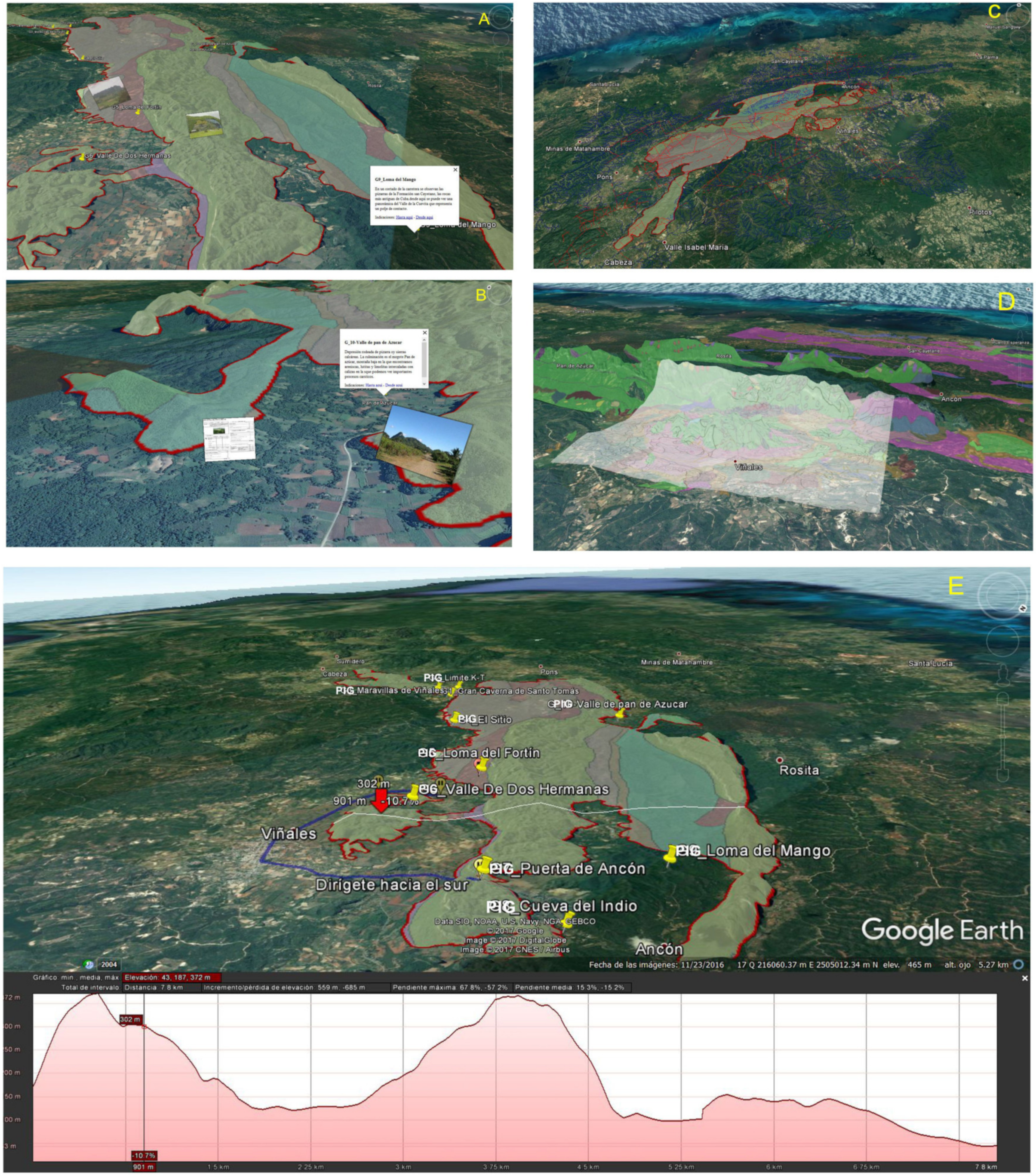
4.1.2. Virtual 3D Itinerary

The 3D virtual flights based on augmented reality techniques for smartphones, tablets and iPads allow the transmission of geological–geomorphological information to social groups (scientific, educational and tourism) and visitors in general. Internet navigators such as Google Earth can help these groups to visualise such information as thematic maps (geological, geomorphological, morphotectonic, Quaternary, etc.) using digital formats (photographs, geological and stratigraphic sections, interpretative panels, files, etc.) for the description of the itineraries by means of 3D virtual flights (Figure 9).
The maps can be superimposed and geo-referenced in free access platforms, such as Google Earth, allowing for obtaining, managing, analysing and reproducing the digital cartography to construct a geo-database, an infrastructure of spatial data (IDEs) that can be implemented in web pages and geo-portals of official national, provincial and local organisms for scientific, educational or recreational usage.

5. Conclusions

  • This paper provides cartographies with various thematic (geological, geomorphological, and morphotectonic) maps necessary for implementation in the 3D virtual itinerary. In addition to the morphology of the hills (mogotes), the cartography of the Viñales valley represents the Quaternary deposits that form the bottom of the polje, assigning them Early, Middle and Late Pleistocene and Holocene ages.
  • Classification and valorisation of geosites. They were ranged according to the total value of the sum of the values of the scientific, didactic and tourism interests. The maximum value is 1030 for geosite 1 (Viñales valley) and the minimum is 365 for geosite 14 (La Jutia valley). As for areas and localities, values range from 2190 (Santo Tomás polje) to 675 (La Cuevita polje).
  • The comparison of the values in this paper and those by Vázquez Torres and collaborators indicates that, even using similar methodologies, there are significant differences concerning the valorisation. These were attributed to the different focus, this paper being more geomorphological and the other more general.
  • The 3D virtual itinerary allows for the diffusion of the knowledge of the geological–geomorphological heritage with geomatics elements that provides a better understanding of the Viñales National Park. It also contributes to a better sustained development of this area, as it provides a simple way to access the telematics information in portable devices, which favours usage not only by scientific, educational and touristic entities but also by the general visitors, as they will have an individual auto-guide to roam the geosites by means of the GPS of the mobile devices.

Author Contributions

Conceptualisation, J.L.G., A.M.M.-G. and C.Z.; methodology, J.L.C., J.Á.G.-D. and I.d.B.; software, A.B., C.E.N. and A.M.M.-G.; validation, C.J.D. and C.Z.; formal analysis, C.D.-G., C.J.D. and J.L.G.; investigation, J.L.G. and C.D.-G. resources, I.d.B. and C.Z.; data curation, A.B. and A.M.M.-G. writing—original draft preparation, J.L.G. and C.D.-G.; writing—review and editing, C.J.D. and J.Á.G.-D.; visualisation, J.L.C. and J.L.G.; supervision, J.L.G.; project administration, J.L.G.; funding acquisition, J.Á.G.-D. All authors have read and agreed to the published version of the manuscript.

Funding

This research was supported by Spanish FEDER-MINECO (Projects CGL15-69919-R), 131874B-I00 funded by MCIN/AEI/ 10.13039/501100011033 and the GEAPAGE research group (Environmental Geomorphology and Geological Heritage) of the University of Salamanca.

Data Availability Statement

Not applicable.

Acknowledgments

The authors would like to show their gratitude to the authors of some of the photographs used by the research team: Figure 6c,j (Marius Jovaisa), Figure 6g (Vázquez Torres, M.—coordinator—2017), Figure 6k and Figure 7 (PNV photo library) thanking them for their use.

Conflicts of Interest

The authors declare no conflict of interest.

References

  1. Brilha, J.B. Inventory and Quantitative Assessment of Geosites and Geodiversity Sites: A Review. Geoheritage 2015, 8, 119–134. [Google Scholar] [CrossRef] [Green Version]
  2. Newsome, D.; Dowling, R.K. Geotourism: The Tourism of Geology and Landscape; Goodfellow Publishers: Oxford, UK, 2010. [Google Scholar]
  3. Reynard, E.; Brilha, J. Geoheritage: Assessment, Protection, and Management; Elsevier: New York, NY, USA, 2017. [Google Scholar]
  4. Ruban, D.A. Geotourism—A geographical review of the literature. Tour. Manag. Perspect. 2015, 15, 1–15. [Google Scholar] [CrossRef]
  5. Zouros, N. The European Geoparks Network—Geological heritage protection and local development. Episodes 2004, 27, 165–171. [Google Scholar] [CrossRef] [Green Version]
  6. UNESCO Global Geoparks. 2023. Available online: https://en.unesco.org/global-geoparks (accessed on 10 February 2023).
  7. Quesada-Román, A.; Pérez-Umaña, D. State of the art of Geodiversity, Geoconservation, and Geotourism in Costa Rica. Geosciences 2020, 10, 211. [Google Scholar] [CrossRef]
  8. Rosado-González, E.M.; Sá, A.A.; Palacio-Prieto, J.L. UNESCO global geoparks in Latin America and the Caribbean, and their contribution to agenda 2030 sustainable development goals. Geoheritage 2020, 12, 1–15. [Google Scholar] [CrossRef]
  9. Quesada-Román, A.; Torres-Bernhard, L.; Ruiz-Álvarez, M.A.; Rodríguez-Madariaga, M.; Velázquez-Espinoza, G.; Espinosa-Veeg, C.; Toral, J.; Rodríguz-Bolaños, H. Geodiversity, Geoconservation, and Geotourism in Central America. Land 2021, 11, 48. [Google Scholar] [CrossRef]
  10. Goy, J.L.; Martínez-Graña, A.M.; Cruz, R.; Andrés, C.; Martínez-Jaráiz, C. Inventario y Catalogación Cartográfica del Patrimonio Geológico (Científico y Didáctico) de la Reserva de la Biosfera de las Sierras de Béjar y Francia. In Colección Patrimonio Geológico; Instituto Geológico y Minero de España (IGME): Madrid, Spain, 2012; Volume 1, 120p, ISBN 978-84-615-9656-0. [Google Scholar]
  11. Goy, J.L.; Corvea, J.L.; Martínez-Graña, A.M.; de Bustamante, I.; Diaz-Guanche, C.; Zazo, C.; González-Delgado, J.A.; Herreros, E.; Blanco, A. Patrimonio Geológico del Parque Nacional Viñales (Pinar del Río, Cuba): Itinerario Virtual para el Geoturismo y la Geoconservación. X Congreso de Áreas Protegidas; La Habana, Cuba, 2017. [Google Scholar]
  12. Corvea, J.L.; Blanco, A.; Bustamante, I.; Farfán, H.; Martínez, Y.; Novo, R.; Díaz, C.; López, N. Advances in Geoconservation in Cuba: Assessment of the Guaniguanico Range and Guanahacabibes Plain (Pinar del Río). Geoheritage 2013, 6, 1–16. [Google Scholar] [CrossRef]
  13. Bruschi, V.M.; Cendrero, A. Geosite evaluation: Can we measure intangible values? IL Quat. 2005, 18, 93–306. [Google Scholar]
  14. Vázquez Torres, M.; (Coordinador). Descripción y Fichas de los Lugares de Interés Geológico del Parque Nacional Viñales, para su propuesta como Geoparque; UNESCO: Paris, France, 2017; 125p. [Google Scholar]
  15. Robaina, A.; Vázquez, M.; Díaz, C. Estudio Geológico y Geomorfológico del Parque Nacional Viñales; Empresa Geominera de Pinar del Río: Viñales, Cuba, 2017. [Google Scholar]
  16. Vázquez Torres, M.; Martínez Rius, A.; Rodríguez Fernández, R.; Gutiérrez Domech, R.M.; Castellanos Abella, E. Parque Nacional Viñales (Cuba). In Guía Geológica; Rodríguez, R., Castellanos, E., Eds.; Instituto Geológico y Minero de España (IGME): Madrid, Spain; Ministerio de Energía y Minas de Cuba (MINEM): La Habana, Cuba, 2021; 204p. [Google Scholar]
  17. García-Cortés, A.; Carcavilla, L. Documento metodológico para la elaboración del inventario español de Lugares de Interés Geológico (IELIG); Instituto Geológico y Minero de España: Madrid, Spain, 2009; 64p. [Google Scholar]
  18. Corvea, J.L.; Novo, R.; Martínez, Y.; de Bustamante, I.; Sanz, J.M. El Parque Nacional Viñales: Un escenario de interés geológico, paleontológico y biológico en el occidente de Cuba. Trab. Geol. 2006, 26, 121–129. [Google Scholar]
  19. Corvea, J.L.; Gutiérrez, R.; Pascual-Aguilar, A.; De Bustamante, I.; Blanco, A. Integration in the Menagement of the Cuba Protected Areas. Geoheritage 2020, 12, 1–16. [Google Scholar] [CrossRef]
  20. IGP. Geositios de Interés Patrimonial en la Provincia de Pinar del Río. Proyecto 6256. Programa Ramal de Minería y Geología; Instituto de Geología y Paleontología: La Habana, Cuba, 2006. [Google Scholar]
  21. Gutiérrez, R.; Bernal, L.; Barrientos, A.; Llanes, A.; López, N.; Flores, L.; Pantaleón, G.; Balado, E.; Corvea, J.L.; Martínez, Y.; et al. Patrimonio Geológico de la Provincia de Pinar del Río. Memorias. Convención Cubana de Ciencias de la Tierra; Geociencias: La Habana, Cuba, 2009. [Google Scholar]
  22. Gutierrez Domech, R. Protecting the Cuban Geological Heritage. Open Geol. J. 2010, 4, 1–14. [Google Scholar] [CrossRef] [Green Version]
  23. Pantaleón, G.J.; Gutiérrez, M.R.; Bernal, L.; Barrientos, A.; Llanes, A.I.; Flores, l. Patrimonio Geológico de las provincias occidentales. Mapa de los Geositios a escala 1:250000. In Memorias, Trabajos y Resúmenes. IV Convención Cubana de Ciencias de la Tierra (Geociencias’ 2011), IX Congreso Cubano de Geología; Centro Nacional de Información Geológica, Instituto de Geología y Paleontología de Cuba: La Habana, Cuba, 2011; pp. 1–9. [Google Scholar]
  24. Vázquez Torres, M.; Robaina Iglesias, A.; Diaz Guanche, C.; Sánchez Carrillo, M.A.; Martínez Serrano, Y.; Izquierdo Martínez, O. Valor del patrimonio geológico, proyecto Geoparque Viñales. Metodología para la selección de los geositios. ECOVIDA 2020, 9, 266–284. [Google Scholar]
  25. Díaz Guanche, C. Geología y Geomorfología del carso de la Sierra de San Vicente Tesis de Maestría, Mención Geología Regional. Master’s Thesis, University of Pinar del Río, Pinar del Río, Cuba, 1999; 51p. [Google Scholar]
  26. Díaz Guanche, C. El Desarrollo del carso Epigenético en el Modelo Evolutivo de la Región Central de la Sierra de los Órganos. Ph.D. Thesis, Universidad de Pinar del Río, Pinar del Río, Cuba, 2017; 174p. [Google Scholar]
  27. IGP. Léxico Estratigráfico de Cuba; Instituto de Geología y Paleontología. Servicio Geológico de Cuba. Ministerio de Energía y Minas, 2013; 459p. [Google Scholar]
  28. Díaz, J.L.; Portela, P.A.; Blanco, S.P.; Magaz, G.A. Características morfoestructurales relieve cubano y su importancia para el estudio de los macizos cársticos. In Resúmenes Simposio XLV de la Sociedad Espeleológica de Cuba; Viñales, Cuba, 1985; p. 59. [Google Scholar]
  29. Martínez-Graña, A.M.; Goy-Goy, J.L.; Zazo-Cardeña, C. Natural Heritage mapping of the Las Batuecas-Sierra de Francia and Quilamas Nature Parks (SW Salamanca, Spain). J. Maps 2011, 7, 600–613. [Google Scholar] [CrossRef] [Green Version]
  30. García Cortés, A.; Carcavilla, L.; Díaz, E.; Vegas, J.; Mugarza, B.A.; Arribas, A.; Bellido, F.; Barrón, E.; Delvene, G.; Martínez, E.D.; et al. Documento Metodológico para la Elaboración del Inventario Español de Lugares de Interés Geológico (IELIG). 2018. Available online: http://www.igme.es/patrimonio/descargas/METODOLOGIA%20IELIG%20V16%20actualizaci%C3%B3n%202018.pdf (accessed on 12 February 2023).
  31. Martínez-Graña, A.M.; Goy, J.L.; Cimarra, C. A virtual tour of geological heritage: Valourising geodiversity using Google Earth and QR code. Comput. Geosci. 2013, 61, 83–93. [Google Scholar] [CrossRef]
  32. Martínez-Graña, A.M.; González-Delgado, J.A.; Pallarés, S.; Goy, J.L.; Civis, J. 3D Virtual Itinerary for Education Using Google Earth as a Tool for the Recovery of the Geological Heritage of Natural Areas: Application in the “Las Batuecas Valley” Nature Park (Salamanca, Spain). Sustainability 2014, 6, 8567–8591. [Google Scholar] [CrossRef] [Green Version]
  33. Martínez-Graña, A.M.; Legoinha, P.; González-Delgado, J.A.; Dabrio, C.J.; Pais, J.; Goy, J.L.; Zazo, C.; Civis, J.; Armenteros, I.; Alonso-Gavilán, G.; et al. Augmented Reality in a Hiking Tour of the Miocene Geoheritage of the Central Algarve Cliffs (Portugal). Geoheritage 2016, 9, 121–131. [Google Scholar] [CrossRef]
  34. González-Delgado, J.A.; Martínez-Graña, A.M.; Civis, J.; Sierro, F.J.; Goy, J.L.; Dabrio, C.J.; Ruiz, F.; González-Regalado, M.L.; Abad, M. Virtual 2D tour of the Neogene paleontological heritage of Huelva (Guadalquivir Basin, Spain). Environ. Earth Sci. 2015, 73, 4609–4618. [Google Scholar] [CrossRef]
  35. Li, B.; Karoly, K.; Zakharovskyi, Z.; Julie Palmer, J.A.; Alan Palmer, A.S.; Proctor, P. Geodiversity Estimate of the Arxan-Chaihe Volcanic Field Extending across Two Geoparks in Inner Mongolia, NE China; Special Publications; Geological Society: London, UK, 2023; Volume 530, pp. 75–95. [Google Scholar] [CrossRef]
  36. Zwoliński, Z.; Brilha, J. Murray Gray and Jack Matthews. In International Geodiversity Day: From Grassroots Geoscience Campaign to UNESCO Recognition; Special Publications; Geological Society: London, UK, 2023; Volume 530, pp. 115–125. [Google Scholar]
  37. Goy, J.L.; Corvea, J.L.; Diaz-Guanche, C.; De Bustamante, I.; Martínez-Graña, A.M.; Zazo, C.; Cruz, R. Cartografía Geomorfológica del Parque Nacional Viñales (Pinar del Rio, Cuba) Congreso: II Simposio Sobre Gestión del Agua en Espacios Protegidos. 36; Baracoa, Cuba, 2014. [Google Scholar]
  38. Lehmann, H.; Krömmelbein, K.; Lötschert, W. Karstmorphologische, Geologische und Botanische studien in der Sierra de los Organos auf Cuba. Erdkunde 1956, 10, 185–204. [Google Scholar] [CrossRef]
  39. Lehmann, H. Las areas carsticas del Caribe. Revista Sociedad Geográfica de Cuba 1960, 45–53. [Google Scholar]
  40. Iturralde-Vinent, M.A. Los Mogotes de la Sierra de los Órganos, Pinar del Río: Su origen, desarrollo y desaparición. Red Cubana de la Ciencia [online]. 2005. Available online: https://www.yumpu.com/es/document/read/46659552/2005-red-cubana-de-la-ciencia (accessed on 10 January 2023).
  41. Molerio, L.F. Los mogotes del Valle de Viñales, Monumento Nacional. Pinar del Río, Cuba. Mapping interactivo. Revista Internacional de Ciencias de la Tierra 2006. Agosto-Septiembre. 18p.
  42. Condis Fernández, M.M. Interferencias Paleoecológicas Sobre Especies de la Mastofauna Cuaternaria Cubana, Conservadas en el Depósito Superficial de la Caverna Geda, Pinar del Río, Cuba. Ph.D. Thesis, Universidad de Alicante, San Vicente del Raspeig, Spain, 2011; 198p. [Google Scholar]
  43. Molerio, L.F.; Flores, E. Paleoclimas y Paleocarsos: Los niveles de cavernamiento y la variabilidad del clima tropical en el Golfo de Mexico y el Caribe. In Investigaciones Hidrogeológicas en Cuba; Arellano, D.M., Antigüedad, I., Eds.; País Vasco, Spain, 1997; pp. 225–230. [Google Scholar]
  44. Molerio, L.F.; Guerra, M.G.; Rocamora, E.; Pajón, J.M. Caracterización de los niveles de cavernamiento del karst de Cuba occidental y su relación con las oscilaciones del nivel del mar durante el Cuaternario (Capitulo 4). In Proyecto Paleoclima del Cuaternario Cubano: Una caracterización Cuantitativa; Banco de Proyectos del Programa Nacional de Cambios globales y la Evolución del Medio Ambiente Cubano: La Habana, Cuba, 1999; Volume 362, pp. 113–170. [Google Scholar]
  45. Rojas, R.; García-Delgado, D.; Diaz, C. Guía de las localidades de los depósitos del límite Cretácico-Terciario en la región occidental de Cuba. In Excursión a Los Depósitos del Límite Cretácico-Terciario en Cuba Occidental; Rojas-Consuegra, R., Núñez-Cambra, K., Eds.; Instituto de Geología y Paleontología; Museo Nacional de Historia Natural: La Habana, Cuba, 2007; 25p. [Google Scholar]
  46. Díaz Otero, C.; Iturralde-Vinent, M.; García Delgado, D. Evidencias del “coctel” paleontológico del límite Cretacico-Terciario en Cuba occidental. Taller internacional sobre eventos en el límite K/T. Memorias Geomin. 2001. [Google Scholar]
  47. Iturralde-Vinent, M.; García-Delgado, C.; Diáz-Otero, R.; Rojas-Consuegra, R.; Tada, R.; Takayama, R.; Kiyokawa, S. The K/T boundary impact layer in lithostratigraphy, facies development and paleogeography. Acta Geol. Pol. 2000, 28, 1–96. [Google Scholar]
  48. Tada, R.; Nakano, Y.; Iturralde-Vinent, M.A.; Yamamoto, S.; Kamada, T.; Tajika, E.; Toyoda, K.; Kiyokawa, S.; García-Delgado, D.; Oji, T. Complex tsunami waves suggested by the cretáceous. In Tertiary Boundary Deposit at the Moncada Section, Western Cuba; Special Paper; Koeberl, C., Macleon, K.G., Eds.; Geological Society of America: Boulder, CO, USA, 2002; Volume 356, pp. 109–123. [Google Scholar]
Figure 1. Location and relief of the Viñales National Park. Cuba.
Sustainability 15 05704 g001
Figure 2. Location of selected geosites (PIG), areas (AIG) and localities (LIG) of geological interest in the VNP.
Sustainability 15 05704 g002
Figure 3. Toponymy, drainage pattern and main relief morphostructural units. Legend: a, b, c, d, e, f and g (in black) are main thrust fronts. These separate the northern (d) from the southern (g) shales, and also the main relief: Los Órganos range (b and c), Guaniguanico range (d and f), Quemados and Tumbaderos ranges (f and g). PF: Pinar fault, GSF: San Felipe trench. Materials (in green): A: northern shales, B: southern shales, C: calcareous ranges, D: metamorphic shales and sandstones (Cangre Belt), E: Los Palacios Basin (Paleogene limestones and sandstones, Neogene marls, Quaternary conglomerates). Main ranges (sierras) and mogotes (in red): 1—Pan de Azúcar Mogote, 2—Abra range, 3—Ancón range, 4—San Vicente range, 5—Chinchones range, 6—Derrmbada range, 7—Sitio del Infierno range, 8—Viñalas range, 9—Guasasa range, 10—Quemado range, 11—Santo Tomás range, 12—Tumbadero range.
Sustainability 15 05704 g003
Figure 4. (A) Satellite image of the Viñales Polje. 1, 2, 3, 4 and 5-PIG (red); A—massive limestones of the Guasasa Fm, B—stratified limestone of Jagua Fm, C—shales of San Cayetano Fm (yellow). I, II and III (green): fluvial, karstic and fluvial–gravity. Rivers (blue): 1—El Tejar, 2—El Novillo tributary, 3—El Novillo, 4 and 5—tributaries to El Tejar, 6—Palmarito. Toponymy (in black): a—Viñales range, b—Guasasa range, c—Ancón abra (karstic canyon), d—San Vicente polje, e—La Penitencia valley, f—Dos Hermanas mogote, g—El Valle Mogote, h—Viñales valley, i—Dos Hermanas karstic canyon and valley, j—Viñales village, k—El Fortín, l—El Novillo sinkhole, m—Palmarito sinkhole. (B) Geomorphological sketch of Viñales (1) and Dos Hermanas (2) valleys. Legend: Fluvial deposits and forms: a—scarps, b—alluvial fans, c—alluvial channels, d—abandoned watercourses, e—terraces, f—flood plains. Karstic: g—scarp of polje, h—dolines, i—Abras (karstic canyons), j—decalcification clays. Gravity: k—colluvium. Paludal; l—semiendorheic. Mixed: m—pediments, n—fluvial–karstic dells. Other symbols: o—faults, p—sinks, q—limit of Viñales and Dos hermanas valleys. Substratum (in ascending order): Sandstones, mudstones, argilites and shales (San Cayetano Fm), 2—stratified limestone (Jagua fm), 3—massive limestones (Mb San Vicente of Guasasa Fm), 4—dolomitic and micritic limestones, microconglomerates (Members El Americano, Tumbadero and Tumbitas, of Guasasa Fm), 5—stratified cherty micritic limestones (Pons Fm), 6—limestones, marls and breccia (Ancón Fm), 7—olistostromic sandstone, limolite, calcarenite, limestone, basalts and serpentinites (Manacas Fm).
Sustainability 15 05704 g004
Figure 5. Mogote Dos Hermanas hill seen from El Fortín. Note the recent fault in the central part of the photograph. Viñales valley.
Sustainability 15 05704 g005
Figure 6. (a) Viñales Valley. In the far end, chains of hills (mogotes) form the Tumbadero range. (b) Palmarito cave, a sink to the longest underground karst complex (Palmarito–Novillo–Pan de Azúcar) of the park. (c) Oblique air view of the Dos Hermanas valley, with hills (mogotes), abra (fissure) and sediments filling the polje. (d) The door of Ancón (fissure) corresponding to an inactive fluvial–karstic canyon. (e) San Vicente valley. The base of limestone walls and the karstic system associated with the present base level of the polje. (f) Indian cave where the Zacarías river flows out of the northern Guasasa range. (g) Santo Tomás valley. A polje filled with sediments of the Manacas Fm plus Quaternary fluvial and karstic deposits. (h) Santo Tomás cave (Great Santo Tomás Cavern) in a large underground karstic complex, up to 57 km long. (i) K-T limit in tsunamigenic deposits of Moncada Fm. (j) Air view of La Jutia polje and Hoyo de Jaruco fissure (abra). Far away Ancón and San Vicente ranges. (k) Ancón Valley in the Ancón–Las Casas polje. Seen from the NW to show the up-filling of Quaternary sediments and vertical-walled hills (mogotes) of the Guasasa Fm. (l) Abra de Ancón. Karstic canyon of the Abra river located between the ranges of Galeras and Ancón ranges. (m) La Cuevita polje as seen from the El Mango range, showing the influence of fractures in the morphology of the hills (mogotes), the westwards tilting, the levels of hanging caves and the Quaternary deposits. (n) Pan de Azúcar mogote in the massive limestones of the Guasasa Fm overlying the fossiliferous of Jagua Fm. and (bottom) San Cayetano Fm. In the foreground, the fluvial–karstic valley of the Pan de Azúcar. (o) Boquerón del Infierno. Inactive fluvial canyon hanging above the thrust front of the Sitio del Infierno thrust.
Sustainability 15 05704 g006
Figure 7. Abra (karstic canyon) between Hoyo de Jaruco an Valle de La Jutía.
Sustainability 15 05704 g007
Figure 8. Distribution of geosites in the three proposed conventional itineraries (field trips).
Sustainability 15 05704 g008
Figure 9. Captures of itineraries implemented in the Google Earth application. (A) Capture of lithological cartography with transparency, superimposed on orthophoto. (B) Active information windows by clicking on each geosite with descriptive and interpretive documentation of each geosite (photographs, diagrams…). (C) Implementation of vector layouts of interest: roads, delimitation of natural spaces, urban area, fractures, etc. (D) Superimposition and georeferencing of the photo-interpreted geomorphological cartography prior to digitisation. (E) Capture of the proposed itinerary (blue line) by Google Earth with follow-up indications taking advantage of the smartphone’s GPS geolocation. These itineraries are calculated in real time between different geosites, allowing knowledge of the degree of difficulty and the slope of the route through a topographic profile.
Sustainability 15 05704 g009
Table 1. Quantitative valorisation of the geosites.
GEOSITESVIÑALES POLJESAN VICENTE POLJESTO. TOMAS POLJELA JUTIA POLJEANCÓN POLJELA CUE-VITA
POLJE
PAN DE AZUCAR
Valley
Boq,
INFIER-NO
Viñales ValleyDos Hermanas ValleySouthNorth
1234567891011121314151617181920
Representativeness41221212224422222212
Character type locality10111121122212222211
Degree of scientific knowledge 40120222224221211224
State of conservation22222221122222222224
Viewing conditions44144422242221424224
Rarity20121111102400000000
Geological diversity42242222122222424212
Educational use42242224142222412444
Logistics infrastructure42441444412210202002
Population density11121212222222222222
Accessibility41144404442410112112
Intrinsic fragility (geosite size)42142410224111222224
Cultural/Natural elements 42424224424422222442
Beauty or spectacularity 42222212222111112221
Informative content/use42221214124221124222
Potential for geotourism44444204424121224212
Proximity to recreational areas42142221110000000000
Socioeconomic environment01001222222422244444
TOTAL5830324935422842373846412722352841353142
Scientific interest300110150230135195155165155190290290160145210155195170120230
Educational interest350165205325215260180295225255220255150120240120220195175240
Touristic–Cultural interest345195170270215270125245230220270200140100155170260200195230
TOTAL1015470525825565725460705610665780745450365605445675565490700
Value of Geomorphological domain34002300219081510506751055700
Disclaimer/Publisher’s Note: The statements, opinions and data contained in all publications are solely those of the individual author(s) and contributor(s) and not of MDPI and/or the editor(s). MDPI and/or the editor(s) disclaim responsibility for any injury to people or property resulting from any ideas, methods, instructions or products referred to in the content.

