Article

AGRI|gen: Analysis and Design of a Parametric Modular System for Vertical Urban Agriculture

1
Civil and Architectural Engineering Departmennt, An-Najah National University, Nablus P.O. Box 7, Palestine
2
Cluster of Excellence IntCDC, University of Stuttgart, 70 174 Stuttgart, Germany
*
Authors to whom correspondence should be addressed.
Sustainability 2023, 15(6), 5284; https://doi.org/10.3390/su15065284
Submission received: 12 February 2023 / Revised: 7 March 2023 / Accepted: 11 March 2023 / Published: 16 March 2023

Abstract

:
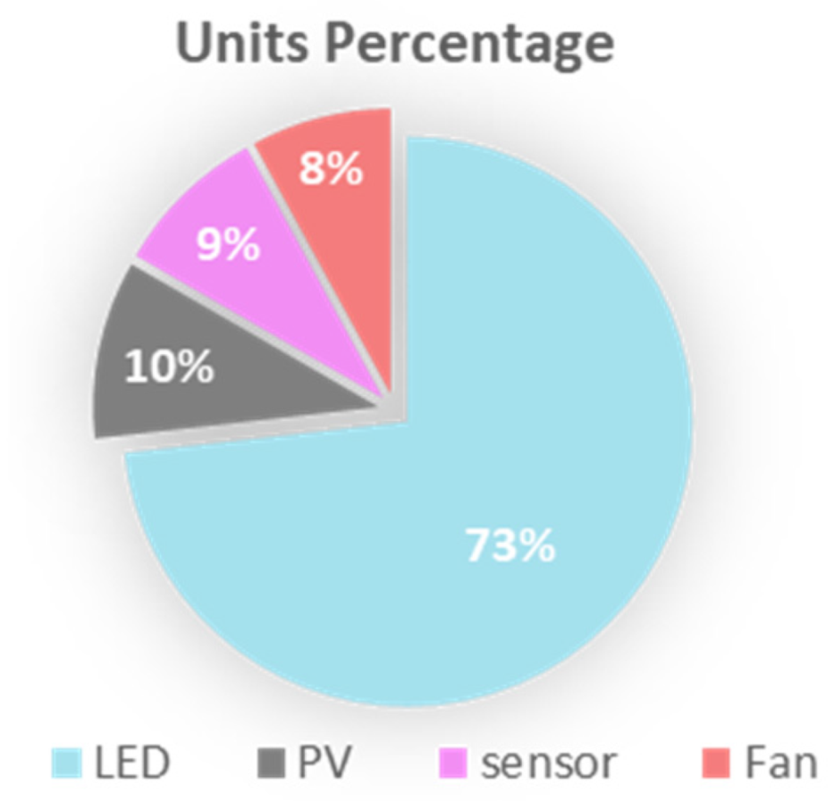
While many studies were done about green facades’ thermal performance, limited studies were done about green facades for productive farming. Most focused only on one facade or building. According to that, this research questioned what the potentials of farming on facades and roofs in an entire neighbourhood are and what could such a farming system looks like, and what it costs. To address these questions, a literature review about urban farming and possible crops was done. A neighbourhood of 22 multi-floor residential buildings in Nablus\Palestine, was chosen as a case study, and two parametric tools, one for analysis (AGRI|gen\Analysis) and another for design (AGRI|gen\design) were developed and implemented. The study found that in the chosen neighbourhood, existing facades can provide about 28,500 m2 of farming area, but only half of the facades and all of the roofs were suitable for daylight-based farming. Tomatoes and cucumbers can be farmed on 25% and 33% of the facades, respectively, to fulfil about 350% and 237% of tomatoes and cucumbers consumption by the same neighbourhood simultaneously. Roofs were found to be more suitable for high DLI-requiring plants like sweet peppers as they can produce more than 315 times the local consumption. In terms of design, a modular adaptive facade system was designed to fit the neighbourhood to enhance the farming possibilities. The facade system needed about 40,824 modular units of which 73.3%, 10.1%, 8.7%, and 8% of them were LED, PV, Sensor, and fan units respectively, with an average system cost of about $55.2\m2 and a total cost of $1.7M. Finally, a comparison between the system and a proposed vertical farm building in the same region was done, and then related recommendations by the researcher were suggested. This research highlights the potential for productive farming on facades and roofs, which could contribute to sustainable and resilient cities.

1. Research Summary

1.1. Introduction

While our global population is predicted to jump over 9 billion by 2040 (which means more resource consumption), our limited natural resources are shrinking as more lands, water, rescores are needed. Additionally, the current industrial soil-based agriculture is responsible for more than 30% of the deforestation in Asia, Africa, and up to 70% in Latin America between 2000–2010. It is also considered a player in the global climate change crisis [1,2]. To address the challenges of limited food, land, and water resources, especially in urban areas, vertical farming buildings have emerged as a potential solution. Examples of such projects include Nuvege in Japan and Plant Lab in Den Bosch, the Netherlands [3]. Despite their potential benefits, these projects require significant investments, including specialized buildings and large budgets (approximately £3000 per sqm) [4]. The high costs associated with vertical farming buildings may limit their implementation to only a few wealthy governments or companies globally. Additionally, while research on green facades has been conducted, much of it has focused on their thermal properties rather than their potential for farming. Furthermore, cost and maintenance requirements have been identified as limitations of vertical green facades [5]. Despite limited research in this area, a promising study was conducted in Singapore in 2018 on the design optimization of vertical productive facades, specifically focusing on the integration of farming planters and photovoltaic units as shading elements for one building in Singapore. However, the scope of the study was limited to a single building only [6].
Parametric architecture, which is a process that uses algorithmic thinking to connect design intent with design response by defining, encoding, and clarifying the relationships between parameters and rules, could be a valuable opportunity for addressing such issues and providing a range of design solutions [7]. One of those solutions could be a modular design. Based on one or more modular units, the fabrication, installation, and maintenance costs of the project could be significantly dropped, and this could make some expensive projects more affordable [8]. In terms of challenges and problems, Palestine is not far different from Singapore in many aspects though having a very different climate. The similarities are population density, water scarcity, and limited farming lands, for example, while the population density in Singapore is about (8358 per km2) [6] it is around (5204 per km2) in Gaza\Palestine [9]. As a result, this research will use a perimetric approach to analyse the vertical farming potential of an entire neighbourhood in Palestine as it will also design a basic modular adaptive vertical farming facades system to be implemented in the same neighbourhood.

1.2. Problem Definition

Instead of tackling the mentioned global challenges by constructing an expensive vertical farming building, and due to the limited research done on vertical farming facades for productive purposes on a neighbourhood scale. This research will target these gaps using a parametric approach by designing an analysis tool (AGRI|gen\Analysis) to analyse the vertical farming potential on the roofs and facades of the existing buildings in a neighbourhood located near the city centre, taking Nablus city in Palestine as a case study. Then using research by design the researchers will develop a design tool (AGRI|gen\design) to design a basic Modular Adaptive Vertical Farming Facades System (MAVFFS) and suggest its implementation considering the design and costs. Then compare those costs to a local vertical farming proposed design.

1.3. Research Objectives

The research has several objectives, which include investigating the feasibility of farming on each façade of a neighbourhood by identifying potential crops, their growing requirements, and expected productivity; calculating the crop consumption of the selected neighbourhood; analysing the farming capacity of the neighbourhood’s facades and roofs; evaluating the percentage of consumption fulfilment by planting crops on roofs and facades in the neighbourhood; designing and implementing a Modular Adaptive Vertical Farming Facades System (MAVFFS) in the neighbourhood; and summarizing observations and recommendations for further research reference.

1.4. Research Questions

Main question:
How to use parametric architectural tools (such as Rhino Grasshopper) to analyse the (facades and roofs) farming potential of a neighbourhood and how to design (MAVFFS), taking a neighbourhood in Nablus city\Palestine as a case study?
Sub questions:
  • How much can a (MAVFFS) produce in terms of yield per year? And how much can it fulfil from local consumption?
  • To what extent can MAVFFS save lands?
  • What are the MAVFFS basic expected costs?
  • How would the modular unit patterns change in the façade according to its position?
  • How would the MAVFFS look on one building and a neighbourhood?

1.5. Research Hypothesis

This research will test to answer the following hypotheses:
  • Growing crops on the facades and roofs of a neighbourhood can fulfil its local consumption of these crops.
  • All the facades and roofs have enough natural light to properly grow the selected crops on them.
  • The basic MAVFFS cost will be less than constructing a vertical farm for the same available farming area.

1.6. Research Methodology

  • To answer the research questions, this research used the following techniques in each stage:

1.6.1. Data Collection

Various types of data were collected for the research, with different sources utilized for each type. Firstly, information on possible crops, including their growing requirements and productivity, was obtained through articles, books, video reports, and field visits to potential sites. Secondly, data on weather and radiation conversion equations, necessary for converting measurements to the required light measurement unit (DLI), was collected from articles, books, and the EnergyPlus weather data website (www.energyplus.net, accessed on 12 August 2020). Lastly, data on the case study neighbourhood in Nablus, Palestine was gathered, including crop consumption per family and building information, such as boundaries, styles, window dimensions, and the number of floors. This information was obtained from the Palestinian Central Bureau of Statistics, aerial photos from the Geomolg website (www.geomolg.ps, accessed on 8 October 2022) which is an authorized spatial information system in Palestine, and site visits.

1.6.2. Data Analysis

The researcher designed a tool called “AGRI|gen\Analysis” to analyse the collected data in several stages. Firstly, modelling the neighbourhood in Grasshopper [10], using the collected data to calculate the number of families and crop consumption. The solar radiation on the facades and roofs was then analysed using the Grasshopper ladybug tool [11] and EPW file. A tool was designed and tested to convert solar radiation values to daylight integral (DLI). The possible farming productivity was analysed and compared to local consumption, and the Modular Adaptive Vertical Farming Facades System (MAVFFS) was designed and implemented in the neighbourhood. Basic expected system costs were calculated and compared to the vertical farm building costs. Possible patterns on different facades were studied and a 3D visualization was done for possible further studies about human acceptance of the system. Finally, the results were concluded and recommendations were formulated.

1.6.3. Research by Design

Research by design is an approach that combines research methods with design thinking to explore and solve complex problems [12,13]. This approach is often used in fields such as architecture, urban planning, and product design, where the design process is used as a tool for inquiry and experimentation. It is characterized by an iterative process of testing and refining design ideas through research, prototyping, and feedback loops [14]. Research by design can lead to new insights and solutions that would not be possible through traditional research methods alone. There are many references to the research-by-design approach, one of the most notable is the work of Schön (1983) in his book “The Reflective Practitioner” where he introduced the concept of reflection-in-action and reflection-on-action as a way to improve design practice [15]. Another notable reference is Cross (2011) in his book “Design Thinking: Understanding How Designers Think and Work” where he discussed the role of design thinking in problem-solving and innovation [16]. According to that, the researcher has developed and used a specially designed parametric tool named “AGRI|gen\Design” during this research.

1.7. Expected Outcomes

This research project aims to achieve several expected outcomes. Firstly, a parametric Rhino Grasshopper tool will be developed to measure the farming potential of a neighbourhood. Secondly, another parametric Rhino Grasshopper tool will be developed to convert solar radiation to DLI values. Thirdly, a parametric Rhino Grasshopper tool will be created to design, distribute, and analyse MAVFFS in a neighbourhood. Fourthly, an Excel sheet will be provided to present a neighbourhood’s farming capacity analysis results in different scenarios. Fifthly, visual images of the MAVFFS in a neighbourhood will be provided to assist designers and researchers in further studies on people’s possible acceptance of the system. Finally, this research project will propose an alternative approach to achieving food sustainability in developing countries, rather than constructing a vertical farming building, by establishing basic data and tools for productive green facade systems in the future.

2. Literature Review

2.1. Global Challenges

By 2050, the world will need to produce 60% more food to meet the demands of the projected 9 billion population. This will require addressing various global challenges, including climate change, rapid urbanization, food shortage, poverty, and scarcity of water and energy [17]. Many sectors are affected by those challenges. However, this research will highlight some major challenges that are related to agriculture.

2.1.1. Climate Change

Nowadays, due to climate change, natural catastrophes are more likely to happen, more forest fires are occurring, drought and deforestation are hitting more areas, and seawater levels are rising. If this rhythm continues, in the coming 50 years, climate change is estimated to cause a 10% loss of used lands for growing crops with every (1 °C) increase in atmospheric temperature, damaging many agricultural activities [2]. Agriculture is not only a victim of climate change. According to the Consultative Group on International Agricultural Research (CGIAR), from making fertilisers to food packing, the world food system makes up one-third of the greenhouse gases produced by humans [18]. Moreover, the current industrial soil-based agriculture is responsible for more than 30% of the deforestation in Asia and Africa, and up to 70% in Latin America between 2000–2010 [1,2]. This also makes it a player in the global climate change crisis.

2.1.2. Water Scarcity

Water scarcity is defined as the absence of enough accessible water resources to fulfil the needs of the population in a specific area. At least one human in each six on this planet does not have enough access to drinking water. In other words, more than 1.2 billion lack access to clean drinking water, while (1.8) billion people will be living in absolute water scarcity by 2025 [19,20]. The current industrial soil-based agriculture is the biggest water-using sector worldwide and the main water polluter too [21].

2.1.3. Rapid Urbanisation

More than two-thirds of the global population will move to live in cities by 2050. This represents a 14% increase from the 54% of people living in urban areas in 2016 [22]. This big shift of moving urban areas means a huge pressure on all the facilities, services, demands, etc. To feed these people, more transported food will be brought to city centres which also means more pressure on transportation and more CO2 emissions.

2.2. Urban Farming

2.2.1. Urban Agriculture

Urban farming, agriculture, or gardening is the practice of planting crops, preparing equipment, taking care of plants, and distributing food in a village, town, or city. Urban agriculture can include animal farming, hydroponics, agroforestry, and gardening. Today urban farming exists in many forms in urban areas, including rooftops, facades, backyard gardens, balcony gardening, the entire building, parks, etc. [23,24].
Urban agriculture has many benefits in many aspects, economically; it encourages producing, preparing, and selling its produced food inside the local society. This will create more jobs and match the increasing food demand, which will reduce food prices making food more affordable and providing supplies for emergencies such as the global coronavirus pandemic. Socially, urban agriculture encourages social interaction within the property. This positive daily social interaction enhances the individual’s emotional status and the entire community’s health [25]. In terms of energy, urban agriculture also saves a lot of wasted food distribution energy and emissions; local food distribution saves 4–15 times fuel and 5–17 times CO2 compared to regional food transportation [26]. Additionally, urban agriculture can help reduce many other urban areas’ problems, such as noise pollution, food injustice, and low food quality [24].
Urban agriculture encompasses various forms, including backyard and rooftop gardens, street landscaping, tactical gardens, as well as vertical greenery systems, and vertical farms [27]. Within these forms, the cultivation process can range from traditional soil-based methods to advanced planetary farming techniques, such as Hydroponic, Aquaponic, and Aeroponic farming. This research will specifically focus on vertical farms and vertical greenery systems as forms of urban agriculture.

2.2.2. Vertical Farming

Vertical farming is a way of planting crops vertically in carrier layers. This system can use soil, hydroponic, or aeroponic planting methods. Vertical farming is a technological system used to produce foods in challenging areas such as high-density regions, urban areas, and shrinking lands; where arable land is rare or unavailable [28]. Vertical farms utilize various technologies to create the ideal environment for plant growth, including automation for monitoring and controlling crops. This ensures that the plants receive proper care and attention through automated lighting, fertilization, and irrigation systems [29].
  • local case study: proposed vertical farm in Nablus
To study the concept of vertical farming in Palestine (locally), this research by design highlights a local proposed case study in the city of Nablus\Palestine (32.2211° N, 35.2544° E) done by a Palestinian researcher Ghadeer Derbas as a master dissertation project (at the University of Jordan) titled “The planning and design of vertical farms: prospects for urban farming in Palestine”. The project was designed to know if vertical farming in Palestine- Nablus is a suitable solution for the Palestinian context, taking into consideration the related Palestinian challenges such as; water scarcity, limited lands, etc. After that, the research proposes some guidelines for vertical farm designing and suggests criteria for choosing a suitable location. The project implements those guidelines to plan and design a vertical farm that is supposed to be suitable for the Palestinian local urban context [30].
This proposed vertical farm contained 10 stories, with a building footprint of 3000 m2 and a total floor area of 12,000 m2. The estimated cost was 15 million Jordanian Dinars (about 21.1 million USD), and the total production expected using this system was (4–45) times the production using the traditional way of farming, as well as the same amount of crops produced by the vertical farming system will require 150 dunams (1 dunam = 1000 m2) of agricultural lands using the traditional farming methods [30]. Finally, the project expects to feed up to 10,000 people. So to feed the city of Nablus (around 350,000 people), The researcher suggests having 30 vertical farming buildings in the city [30].

2.2.3. Brief Definition of Vertical Greenery Systems

The urban heat island effect became a serious problem in city centres due to the increase in cities’ population and the decrease in green spaces. To address this problem, the old habit of growing plants on building facades started to gain attention again under the name of vertical greenery systems (VGS). VGS refers to the practice of growing vegetation vertically and has many names such as the green wall, bio-shader, vertical garden, vertical landscaping, and vertical greenery; all of the used names can be classified according to their construction system to living walls or green facade [31,32].
A green facade is used to reflect the scenario in which the plants are placed in the ground or planting box above the ground and then attached to the wall either directly or indirectly (by special wires). In this case, plants could live more than 50 years [33]. The living wall is used to represent the scenario in which the plants are grown in special planting containers attached to the wall and watered mechanically, so the plants don’t have any other place to root in rather than the container. This system is suitable for hydroponic growing crops [34], and it is going to be used for growing in this research. VGS has many indirect and direct advantages, such as: enhancing the quality of air, reducing noise, improving biodiversity, and providing more green building rating points for the buildings, as it also can add to the aesthetical value of the area [5].
According to a systematic review of research trends done about Vertical greenery systems, there are 13 main research themes about VGS, but almost half of the publications were about the thermal performance of VGS, while the maintenance and costs were considered as the most limitations for VGS [5]. So, to fill these gaps, this research will study the productivity and cost factors and implement a modular system that is expected to be cheaper and easy to maintain.
  • International case study (1): Proposed productive facade in Singapore:
Despite limited research on the use of vertical greenery systems (VGS) for production purposes, a study conducted in Singapore in 2018 delved into this field. The paper first discussed the general challenges related to this area in Singapore, including the fact that 95% of the resources needed to generate electricity and more than 90% of indoor consumed food supplies are imported. Additionally, Singapore’s high population density of 7796 persons per km2, with 94.6% of the population residing in multi-story buildings, was noted as a contributing factor [6]. In its productive facade, the paper suggested having solar panels as a source of electricity and shade alongside growing planters as a source of food. This system was proposed on two options; a balcony facade and a windowed facade for the four elevations, making them eight options [6].
To optimise the eight options, the researchers set five main criteria; food, energy, thermal, indoor daylight, and view angle potentials. Those criteria were evaluated using the Grasshopper and then using VIKOR (multi-criteria optimisation) method, to get the optimal design. The final results showed that most of the facades’ solar panels should be highly tilted, and the eastern and western facades need greater solar protection. They also suggested having two planters slightly below the windows; so that a 20 m2 facade could produce 35–66 kg of leafy greens, which is 55–103% of the medium four-member family consumption in Singapore. Finally, a prototype of the optimal facade was installed in the Tropical Technologies Laboratory (T2 Lab) in Singapore [6].

2.3. General Hydroponic Crops Growing Requirements

The term “Hydroponics” is derived from the Greek words “hydro,” meaning water, and “ponos,” meaning work, thus translating to “working with water.” This method of cultivation involves growing the roots of plants in water that is enriched with nutrients, rather than soil. As a result, Hydroponics is a versatile system that can be used for both indoor and outdoor farming operations, such as on roofs and green walls, and it also provides several advantages over traditional soil-based growing methods [35]. Hydroponic systems require significantly less space for root growth since the roots have direct access to oxygenated nutrient elements in their planting container, rather than needing to expand deeper into the soil in search of nutrients. This means that, with the appropriate growing conditions, hydroponic crops can be grown almost anywhere, year-round. Additionally, the use of a covered water tray for nutrient delivery is a cleaner method of harvesting and can save up to 90% of the water used compared to traditional methods, while also allowing for the production of up to 80% more crops in 30% less time [36]. For a hydroponic system to be successful in growing profitable, healthy plants, the appropriate growing conditions must be met. These conditions may vary depending on the plant species, but generally, the main growth factors are;
  • Oxygen(O2) and carbon dioxide (CO2): Like most other creatures, plants need oxygen in the air, but having it in the water enhances nutrient absorption. Moreover, carbon dioxide is also needed for the photosynthesis process. Both gases exist within the normal breathable air at an acceptable rate for plant growth.
  • Water (H2O): Water works as a solvent solution for the nutrients and oxygen as it also has a role in metabolic operations; water with 5.00–7.00 pH is generally required.
  • Nutrients: Nutrients represent the needed food for plants. Phosphorus (P), Potassium (K), and Nitrogen (N) are the most needed nutrients, and they are commercially available in many formulas.
  • Temperature: Temperature is an important factor in hydroponic systems as it affects both the dissolved oxygen in the water and the metabolic activity of the plants. Ideally, the water and ambient temperature should be maintained between 18–25 °C to ensure optimal growth and development.
  • Light: Light intensity, spectrum, and duration are one of the most affecting factors. These will be explained in detail in the next section [35].

2.3.1. Crops Light Requirements

Since all the previously mentioned growing requirements are easier to control, light is the main playing role factor. Each crop needs a minimum specified amount of light for photosynthesis, which can be provided by Natural or artificial light sources [37]. In terms of duration, the light should be provided for about 8–10 h daily. Additionally, the spectrum and intensity of the light should also be taken into account, terms such as PAR, PPFD, and DLI are explained below:
PAR:
The term PAR refers to (Photosynthetically Active Radiation) which simply means the light spectrum within the visible light 400 to 700 nanometres (nm) which is the active light in the plant’s photosynthesis [38].
PPFD:
Photosynthetic Photon Flux Density (PPFD) represents the count of PAR Photons (in micromoles) that hit the plant surface per second μmol m−2 s−1 (micromoles per meter squared per second). The needed efficient amount for plant growth is 500–1500 μmol m−2 s−1, while the sunlight gives 900–1500 μmol m−2 s−1 [38].
DLI:
Daylight integral (DLI) represents how many active photons are received in a defined area during the day. It is considered a very helpful indicator for farmers to decide according to it what possible plants to be planted under the available light, or if the farmer needs any supplementary light source. The formula for calculating DLI is μmol m−2 s−1 (or PPFD) × (3600 × photoperiod)/1,000,000 = DLI (or moles/m2/day)” [39] (see Figure 1).
  • International case study (2): 3D city models for urban farming site identification in buildings.
Among the limited research about facade urban farming. The paper “3D city models for urban farming site identification in buildings” explores the potential for urban farming on facades in Singapore using and comparing both three-dimensional (3D) city models and field visits and time-consuming measurements to measure photosynthetically active radiation (PAR) on residential building facades, windows, and outdoor corridors. The paper found a strong correlation between the 3D city models simulation and field data collection (above 0.5 correlation coefficients in most cases), The paper also examined the spatiotemporal features of PAR within the building and investigated how shadows and diverse weather conditions affect it. It concluded that 3D city models can offer a practical solution to be used to identify suitable farming locations on an urban scale [40].
Even though the paper had a high-resolution PAR measurement at an urban scale in Singapore, the paper did not address the best crops for each location, the urban area crop consumption, potential crop yields, fulfilment percentage (production divided by consumption) and the installation costs of such farming system for that neighbourhood. In contrast, the author’s research aims to use a different tool (Rhino Grasshopper) [10] to conduct a similar DLI analysis and to address the missing issues to provide a more comprehensive understanding of the potential for facade farming on an urban scale in a different location but with similar conditions.

2.3.2. Possible Crops for Vertical Farming:

Theoretically, as long as the growing conditions are matched, most of the crops can be planted hydroponically, but technically some crops are more efficient to be hydroponically planted than others. Table 1 and Table 2 name some suggested herbs and vegetables for hydroponic growing and the preferred methods of planting (from seeds or cuttings) [41].
Among the mentioned crops, some are more suitable than others in different circumstances and geographical locations. According to that the selected crops and the selection criteria will be further explained later in this research.

2.4. Parametric and Modular Architecture

Computational techniques are increasingly essential across various fields, including architecture, as they empower designers and architects to develop algorithmic systems and codes that can help them solve intricate design challenges and make modifications to their designs based on a range of factors such as structural integrity, environmental impact, aesthetics, and cost, among others. These factors are frequently defined using mathematical equations and codes. Parametric architecture is a design approach that is rooted in algorithmic thinking and aims to transform challenges into measurable parameters [7], offering a diverse range of design solutions, including modular design. The use of modular units can significantly reduce the cost of fabrication, installation, and maintenance, making some previously unaffordable projects more financially viable [5].
Parametric architecture is closely tied to digitalization, and as a result, many tools and software programs are used in this field. One such tool is Rhino Grasshopper, a visual coding-based plugin for Rhino that was launched in 2007. It is primarily used for algorithmic design modelling. AEC Magazine stated that Grasshopper is “Popular among students and professionals” [42]. McNeel Associate’s said: “Rhino modelling tool is endemic in the architectural design world. The new Grasshopper environment provides an intuitive way to explore designs without having to learn to script” [43,44].
Since its launch, Grasshopper has been widely adopted by a variety of research groups and design firms. This is due to its credibility, which is supported by the large number of active users sharing their work on web forums and the availability of a wide range of plugins for Grasshopper. This makes it suitable for a variety of testing and simulation operations. Therefore, this research is utilizing Grasshopper as the primary tool for analysis and design.

3. Case Study

To investigate the feasibility of cultivating crops on the facades and roofs of a neighbourhood, a specific location should be chosen. The selection process should take into account factors such as the country, city, and urban context. By selecting a specific area, the researcher can then delve into the specific conditions of that area, including the types of crops that are commonly consumed in that region and the environmental conditions necessary for their growth.

3.1. Site Selection

3.1.1. Site Selection Criteria

The site selection process had the following hierarchy divided into; country, city, and neighbourhood scales.
(A)
Country scale:
Countries with limited lands and resources are prioritized in the selection process because they have a greater need to utilize available space efficiently for food production. Countries with higher solar radiation levels are prioritized because they have better conditions for plant growth and therefore more potential for successful farming on facades and roofs. Similarly, countries with higher urban densities are prioritized because there is a greater potential for utilizing unused space in urban areas for food production. Countries with medium spending styles are prioritized because they have the means to invest in technology and infrastructure for facade and roof farming, but also have a greater need for local food production (this might be also for food security due to a difficult political situation). Additionally, countries with more farming challenges are prioritized because they have a greater need for innovative solutions to food production.
(B)
City Scale:
Cities with a higher population are prioritized in the selection process for facade and roof farming because they have a greater demand for food. This is important as the goal of the facade and roof farming is to increase food production in urban areas. Cities with more suitable weather for farming are also prioritized, as optimal growing conditions are necessary for successful facade and roof farming. In addition, priority is given to industrial cities as they have a greater need for innovative solutions to food production since they are less likely to have access to large agricultural lands and they have a greater need for locally-sourced food to support their population and workforce. Lastly, central cities are prioritized because they have stronger connections with neighbouring cities, surrounding villages, and markets, making it easier to distribute locally grown food.
(C)
Neighbourhood Scale:
At the neighbourhood Scale; Priority is given to areas that have the potential for successful facade and roof farming. This includes neighbourhoods with higher residential and commercial buildings as taller facades provide more potential for growing food. Areas, where the majority of buildings have low architectural value and poor or no architectural style, are also prioritized, as these buildings are more likely to be suitable for facade and roof farming without compromising the aesthetic of the area. Neighbourhoods closer to city centres are prioritized as they have a greater demand for locally grown food and are more accessible for distribution. Additionally, neighbourhoods closer to research centres such as universities and schools are prioritized as researchers can access the site more easily for research and development of facade and roof farming techniques. Additionally, areas with harder topographies such as mountains are prioritized as facades and roof farming can provide a viable solution for food production in these harder-to-farm areas.

3.1.2. Chosen Country Analysis

Palestine is a developing country, located in the middle east. Being under Israeli occupation makes it a case of socio-economic, environmental, and political instability. It has about 5,101,152 people [9] living within its borders, facing; water, resources, borders, and land shrinking challenges, for example; the percentage of rural areas (which got the majority of the agricultural lands) in West Bank decreased from 37% in 1997 to 16.1% in 2010 [45]. Even though it plays an important role in Palestinian GDP, the agricultural sector in Palestine faces many challenges and suffers from the lack of natural resources such as water, energy, and fertile lands, in addition to its lack of control over the limited resources [46,47] (see Figure 2). In addition, Palestine has a semi-arid Mediterranean climate, characterized by two distinct seasons. The summer season is hot and dry, with temperatures ranging from 25 to 35 °C, while the winter season is mild and wet, with temperatures ranging from 7 to 12 °C. This climate makes it suitable for growing a wide range of its locally consumed crops [48]. The above challenges and potentials show that Palestine has a greater need to utilize available space efficiently for food production making it a good case study for this research.

3.1.3. City Analysis

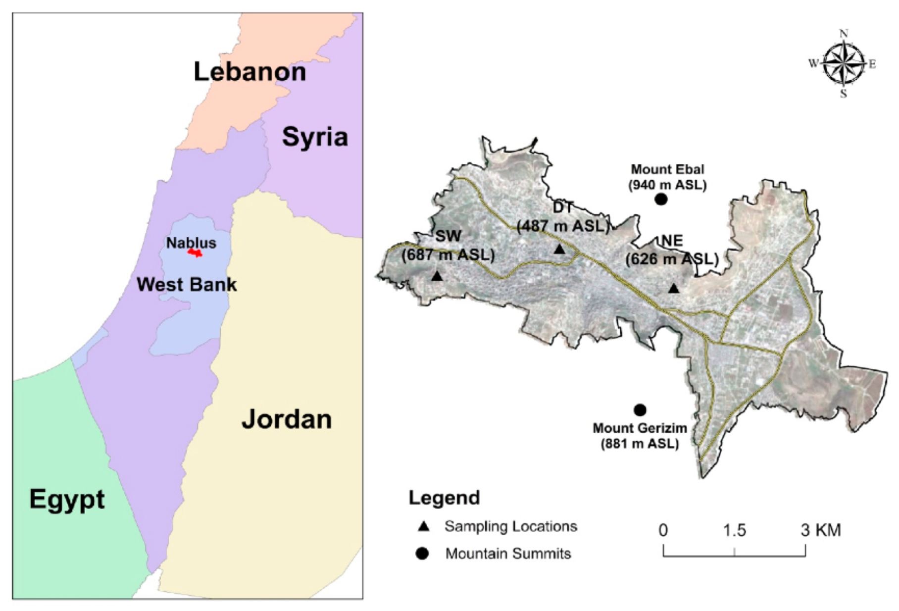
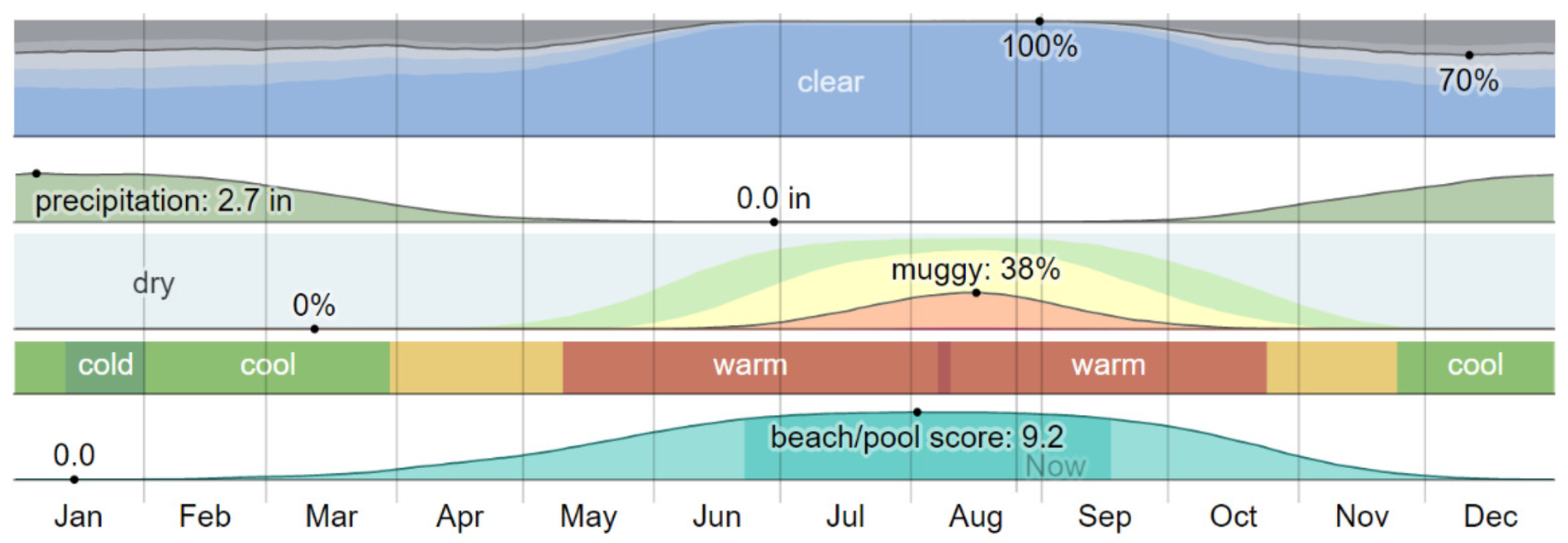
Nablus is a Palestinian city north of the West Bank. It is located between two mountains (Ebal and Jerzeem) which created many challenges for agriculture and urban expansion around the city (see Figure 3 and Figure 4) [49]. Moreover, it has a population of 164,758 people, living in a total area of 28.57 km2 [9,50,51]. In terms of weather, Nablus has a long summer and a cold, mostly clear winter. The average temperature in Nablus ranges between 15 °C–27 °C, which suits most of the local crops (see Figure 5) [9,52]. Called; the economic capital of Palestine, Nablus has strong networks with adjacent cities (like; Qalqilya, Tulkarm, Jenin, and Ramallah), its surrounding villages, and local markets.

3.1.4. Neighbourhood Analysis

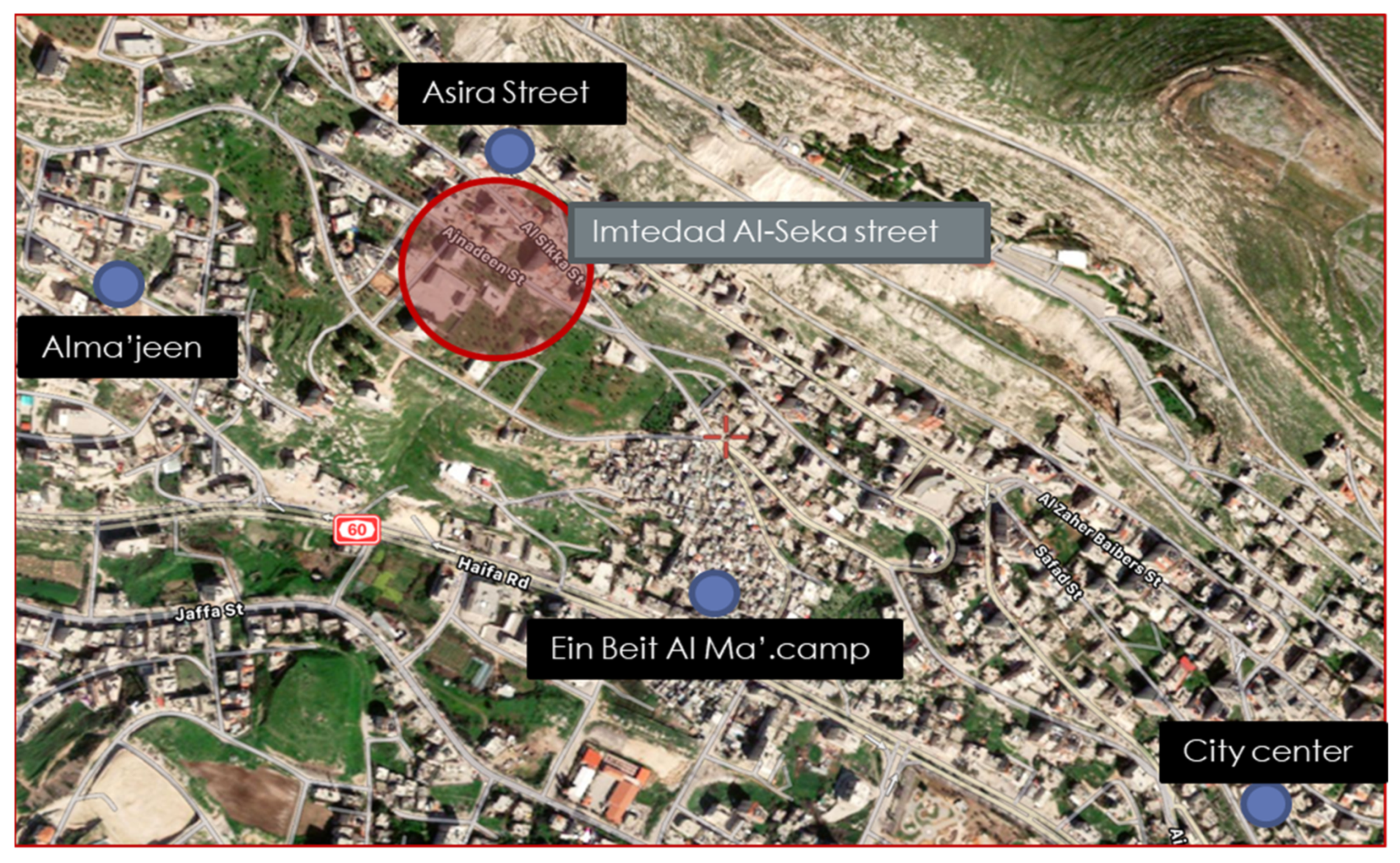
Imtedad Al-Seka is one of the neighbourhoods located to the North-west of Nablus city. This neighbourhood has a vital strategic location connected to many surrounding urban areas like; Asira Street, Alma’ajeen, and Ein Beit Al ‘Ma’ refugee camp neighbourhoods, Asira, and Zawata villages, and also Tulkarem city through main road networks. Moreover, it is also close to the main local market Al-Souq Al-Gharbi near to city centre and many other retail shops. Furthermore, this neighbourhood is close to universities AN-Najah National University, AL-Quds Open University, and Sarem Aldeen Alnajme school [53] (see Figure 6 and Figure 7).
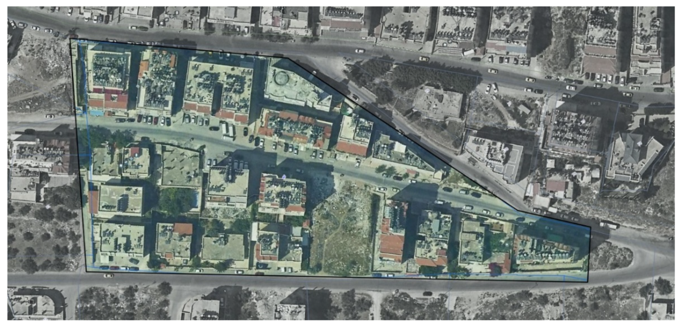
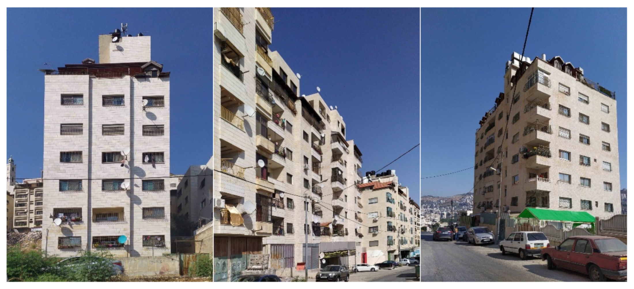
The 20,700 m2 neighbourhood contains 22 multi floors-apartment buildings ranging from 2–11 floors in height, with low-cost materials and basic designs (low architectural value), see Figure 8. Furthermore, it is located on a high slope land of about 15%. All those details made this neighbourhood ideal for the research purpose.

3.2. Crops Selection

3.2.1. Crops Selection Criteria

For optimal farming results, the selection of the wanted crops for farming on facades should consider some aspects. This research studied the crop selection criteria done by both case studies mentioned in the literature review [6,30], and those aspects are:
  • Hydroponic farming possibility:
The selected crops should be possible to grow hydroponically on facades and roofs of the buildings, as they should be easy to maintain by occupants (unskilled residents) and should match the available planting volume.
  • Available natural DLI:
Despite the possibility of installing LED supplementary light units mentioned later, the required DLI for selected crops to grow profitably should be around the available DLI in the farming location. However, having a higher DLI value than needed is acceptable as each extra single DLI unit can increase productivity by 1% up to a different limit for each plant [54]. In other words, each facade and roof has a different DLI, so they should have different possible crops to grow. Matching this aspect will save energy by reducing the need to use the LED supplementary light units.
  • Acceptable Plant growing conditions:
Since the plants are supposed to be planted in front of the resident’s windows and above their roofs, the required growing conditions for the selected plants should be around human comfort conditions. According to that, the required growing temperature for the selected crops should be between 22–27 and the relative humidity between 40–60% [55]. As a result, matching this aspect will make the facades and roof farming idea more acceptable.
  • Local consideration:
To effectively utilize urban farming to meet local food needs, it is important to consider the crops that are most commonly consumed by the local population and are well-suited to the local environmental conditions. This not only increases the likelihood of successful crop growth but also promotes the idea of locally-sourced food and may increase productivity by reducing the energy required to match growing conditions. Additionally, selecting crops with a high market value can provide a source of income for the urban farming system and help to reduce local expenditure on those crops.

3.2.2. Selected Crops Requirements, Productivity, and Consumption

Based on the explained selection criteria, a detailed selection process was conducted. The main selected crops were; (Sweet peppers, tomatoes, cucumber, herbs, lettuce, and microgreens). According to that, the following Table 3 summarises the required light and temperature, as also the annual local consumption in kg per family in Palestine and the annual productivity of those crops in kg per m2.

4. Analysis Process

4.1. General Diagram for the Capacity Analyzing Tool

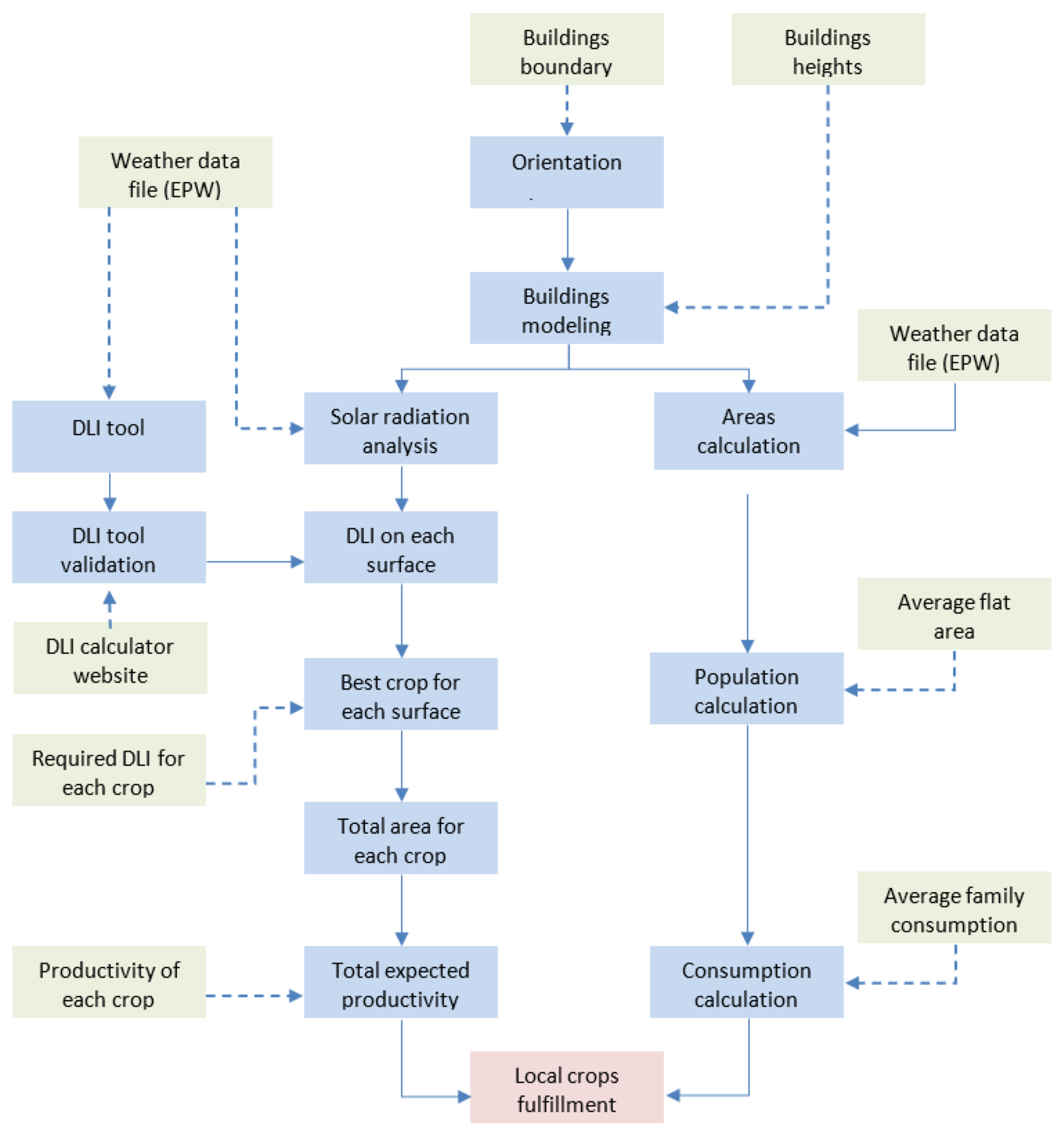
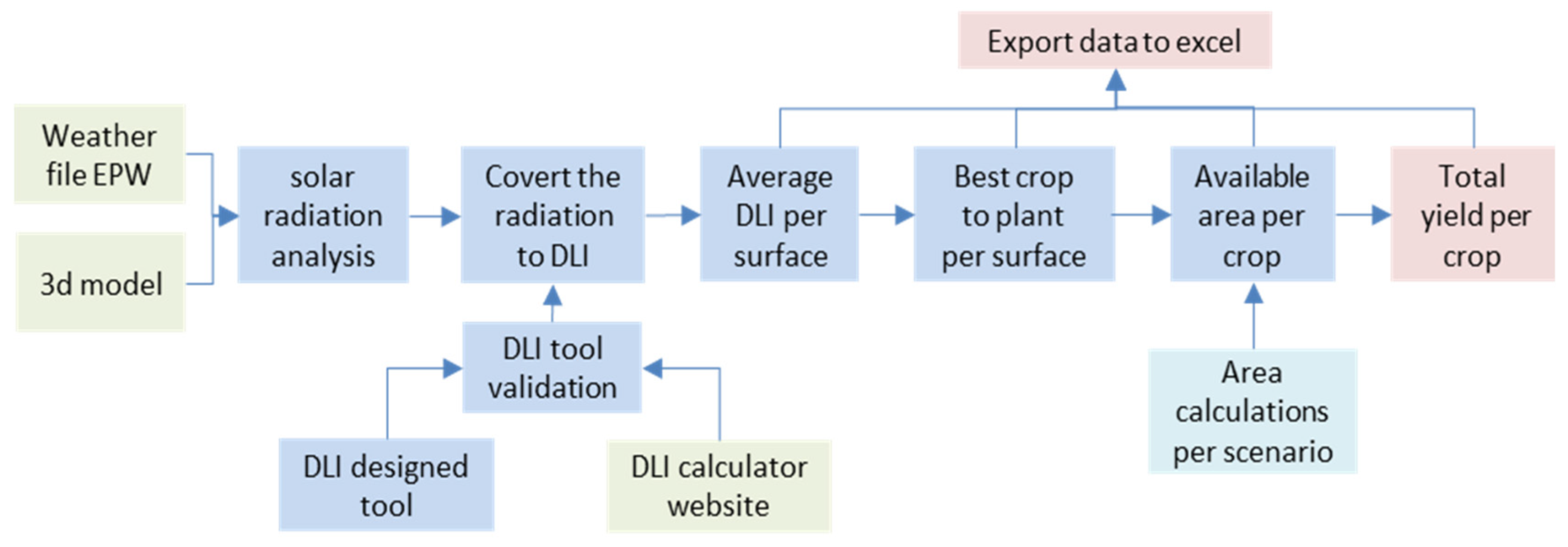
To answer the question “How much did a (MAVFFS) produce in terms of yield per year? And how much did it meet the local consumption?”, a custom parametric Capacity “AGRI|gen\Analysis” Tool was developed. This tool inputs basic information about the desired neighbourhood then processes the data and outputs an excel sheet that showcases the expected consumption and potential production. The comparison between the two values demonstrates the extent to which the production can meet local needs. The input data used in this research is specific to the neighbourhood selected in the previous chapter, but the tool can also be used for other neighbourhoods in the future. Additionally, the following Figure 9 illustrates the general algorithm of the analysing tool.

4.2. Analysis Tool Basic Inputs

To start processing, the AGRI|gen\Analysis tool needs some basic data related to the chosen neighbourhood. These data have different sources, values, and formats and can be grouped accordingly as the following:

4.2.1. Neighbourhood Buildings Boundaries

Neighbourhood buildings boundaries data contains information about all the boundaries of each building footprint in the neighbourhood. Those boundaries should be closed polylines (one closed 2D shape) and have the Z level (height) of the building basement. All the lines should be in one file with an appropriate extension for example (.DWG). This data can be collected from the neighbourhood master plan or manually by drawing over a high-resolution aerial photo and then exporting the lines with levels in a CAD format. The manual method was used in this research for the chosen neighbourhood because no recent neighbourhood master plan was available (see Figure 10).

4.2.2. Neighbourhood Buildings Data

Neighbourhood buildings data contains needed information about each building in the selected neighbourhood, such as; windows count and dimensions per floor for each facade. In addition to that, it contains the floor height and counts for each building. This data can be collected from already existing geographical information data, for example, a GIS file, or if such data is not available (as in this case) it can be collected by a field survey and then should be tabled in a customised Excel template (that is designed especially for AGRI|gen\Analysis tool). The reason behind using excel is to make it a simple-to-use tool that doesn’t need previous knowledge to enter such a large number of inputs directly to Rhino Grasshopper. In this research to collect the data, the researcher had to document each building manually.

4.2.3. Neighbourhood Weather File (EPW)

The climate data file is a file that contains climate information, such as the “Typical Meteorological Years (TMY)” for a specific location. This file is specially designed to help to build simulation tools and has been introduced by many organisations, such as EnergyPlus™, which has the famous format EPW (EnergyPlus Weather) [56,57]. Each local zone should have a unique EPW file which can be found on their website. Therefore, the EPW file used in this research is the nearest available file near Ramallah city, which is only 35 km far from Nablus with very similar weather.

4.2.4. Neighbourhood Local Statistics

The following data represent some local information about the neighbourhood which are the average flat area and the consumption of the average crops by family. These data can be collected either from the official statistics offices or by special field surveys. In this research, the data were collected from the Palestinian Central Bureau of Statistics, and the results suggest that the average flat area is 130 m2 [9], and the average consumption of local food, is shown in Table 4 [58].

4.3. Site Modelling

The site modelling part explains the used algorithm to convert the inputs into a 3d model for the neighbourhood using Rhino Grasshopper.

4.3.1. Reading Excel Data

The first challenge in the AGRI|gen\Analysis tool is to read the input excel file and convert it into parameters in the Grasshopper tool, to tackle this challenge. The TT Toolbox plugin was used. The plugin enables the establishment of a dynamic connection between the excel file and the Grasshopper workflow at the same time. Therefore, if any data gets modified, the workflow gets directly updated. This connection has been used for both reading input from and writing results to the excel file.

4.3.2. Orientation Detection

To build an accurate model that matches the input excel file and to define the elevations, the AGRI|gen\Analysis tool uses the following algorithm to detect the north, east, south, and west facades. At first, a shape centre point is defined, then the polyline edges are deconstructed, midpoints of each edge are defined, and vectors from the shape centre to the points are created. After that, the shortest angle between the created victors and the four main directions vectors is measured so that the polyline edge is attached to the closest main vector list.

4.3.3. Buildings Modelling

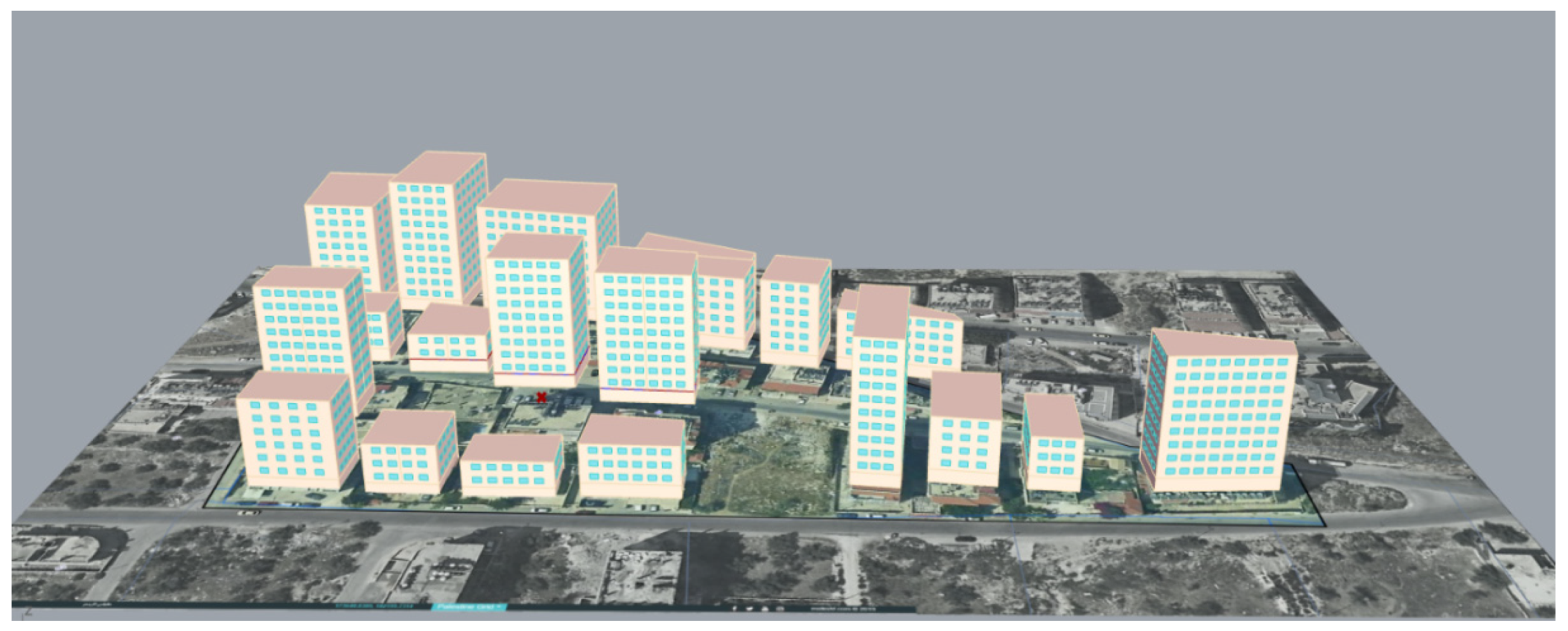
The buildings Modelling part of the process involved grouping all the lines into four main categories (North, East, South, West) and using the excel data about each building’s facade to create a 3D model of all the buildings in the neighbourhood. Each line was extruded vertically by the building height (floor height * floors count). After that, the windows were placed along the facade according to their count and dimensions and then the entire facade was established (see Figure 11).

4.3.4. Data Tree Structure

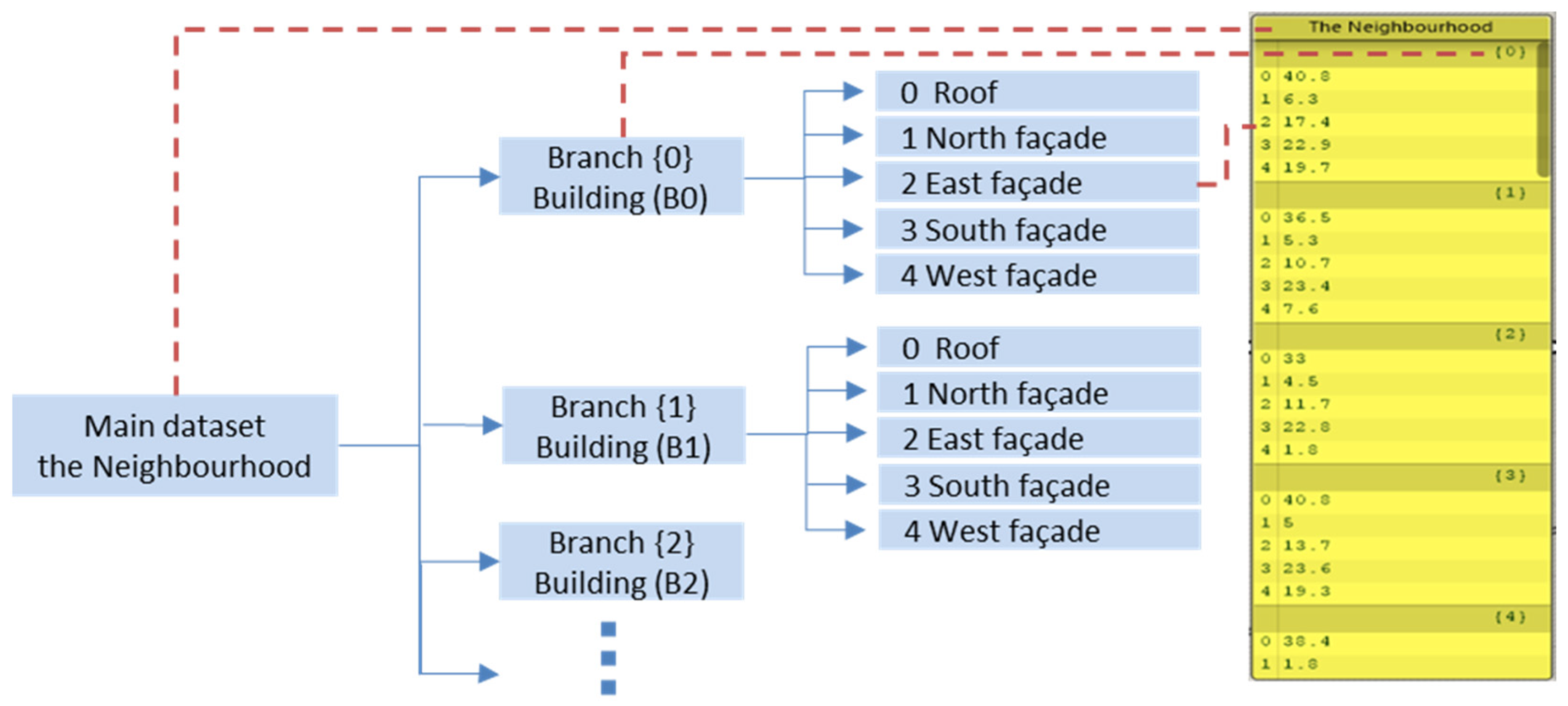
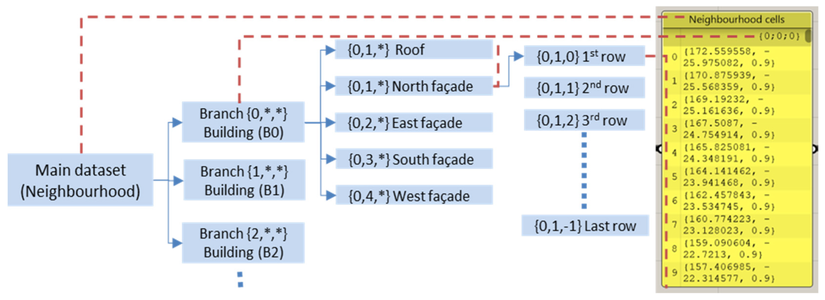
One of the important techniques to deal with nested data is to use data trees. As a result, the following tree structure has been used in this tool so that the entire data set represents the neighbourhood. Each branch represents a building, and each item in the branch represents an elevation. This way, many types of data can be delivered easily within the same tree structure (see Figure 12).

4.4. Neighbourhood Consumption Analysis

The 3D model of the neighbourhood that was created was utilized in the following steps to determine the available farming areas and calculate the population and crop consumption of the neighbourhood.

4.4.1. Areas Calculations

Depending on the previously generated 3D model of the neighbourhood, the available possible areas for farming got measured. To be more realistic AGRI|gen\Analysis tool took into consideration that there are three possible scenarios for facade farming. The first is for families who want to only on-farm on their widows, the second is for families who want to adjust their window to be a glass wall and farm on it, and the third is for families who want to farm on the entire facade (see Figure 13).
After considering the three different scenarios, the AGRI|gen\Analysis tool calculated the total possible area for each scenario as if it was applied alone. For scenario number one the area was equal to the area of the window. For scenario number two the area was equal to the window width multiplied by the floor height. For scenario number three, the total area was equal to the total facade area. For each scenario, all the elements areas within the facade were summed. Later on, the roof area was added then all the areas were delivered back to the excel file using the previously mentioned data tree structure and TT Toolbox plugin.

4.4.2. Population Calculation

To estimate its consumption, the neighbourhood population should be known. Therefore, the floor area was calculated and then divided by the average flat area in Palestine, which is 130 m2, to get the number of flats in the neighbourhood. Each flat equals one family, so when multiplied by the average family size in Palestine, which is 4.8, it gives the neighbourhood’s total population [9]. In this case, the total number of families was 346, and the neighbourhood population was 1661 people.

4.4.3. Consumption Calculation

AGRI|gen\Analysis tool estimated the neighbourhood consumption by multiplying the total number of families with the local consumption of each crop per family, as previously mentioned in Section 3. The final results are shown in Table 5:

4.5. Neighbourhood Production Analysis

AGRI|gen\Analysis tool used weather data, the 3D model generated previously, and the calculated areas to determine the available DLI and select the best crop to plant on each surface. The expected total productivity was then calculated using the algorithm described below, and the results were presented in an excel sheet as shown in Figure 14.

4.5.1. Solar Radiation Calculation

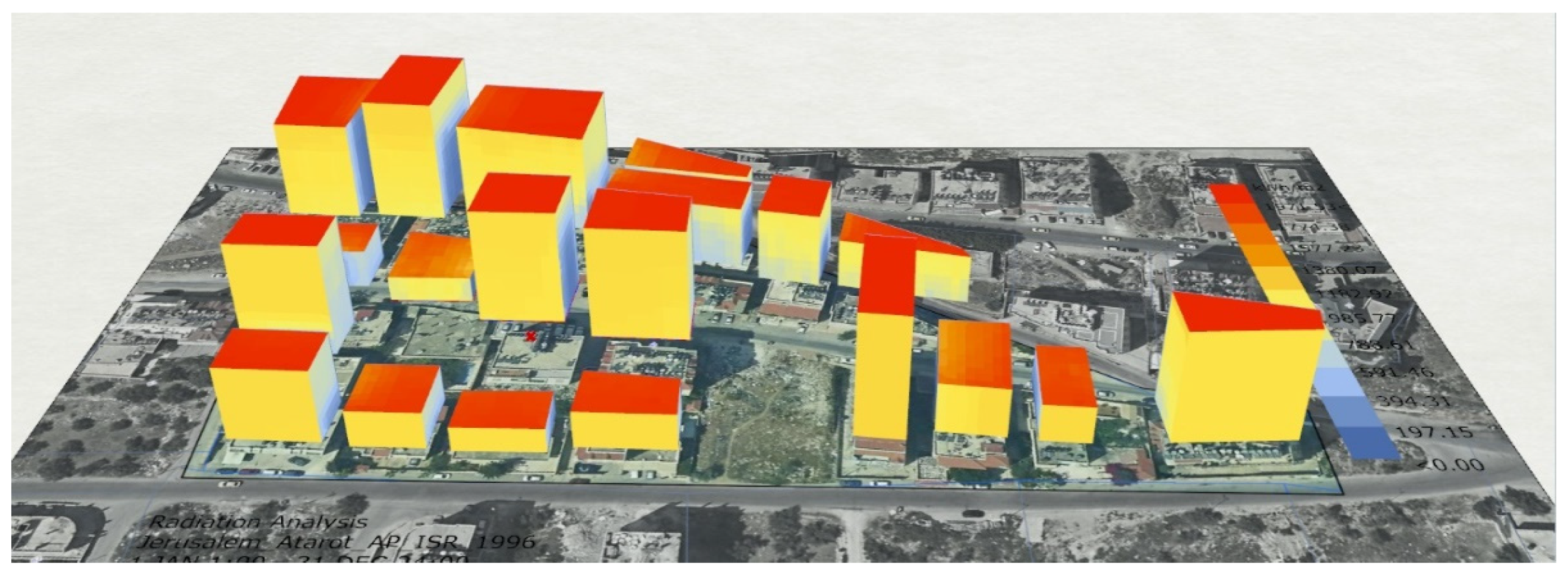
The Ladybug plugin was used to measure the solar radiation on each surface. This tool, developed by Mostapha Roudsari [11], enables users to perform various environmental analyses, such as solar radiation, sun, wind, and view analysis, making it popular among researchers. A neighbourhood-scale study of annual cumulative solar radiation was conducted, taking into account the impact of each building on others, using the EPW weather file to obtain radiation values on grid-based test points and then measuring the average value for each surface. The result of this process is illustrated in Figure 15.

4.5.2. DLI Values on Different Surfaces

Although the average solar radiation per surface was determined in a previous step, it is not sufficient to determine if the selected plants can thrive in this environment. To do so, Daylight Integral (DLI) values are necessary. Up to the date of this research, there is no publicly available tool to measure DLI on surfaces, instead, some website calculators only provide estimated DLI values based on geographical location. This research fills this gap by using the algorithm in Figure 16 to develop a tool for converting solar radiation to DLI. The results of this tool were compared with the available websites for validation before it was used in the Grasshopper workflow for the research.
  • DLI calculator website
As mentioned earlier, some basic websites give general DLI expectations according to geographical location. One of those websites is (www.AGRITECTURE.com, accessed on 15 August 2020) [59]. Using it, the researcher got the result for Nablus city. Even though the research gives general data, these data are not very useful for facades as their access to natural sunlight is less than on roofs and varies from one facade to another [59].
  • DLI designed tool
The main concept behind this tool is to convert solar radiation (kwh\m2) to daylight integral in (μmole m2/day) the tool relied on the mentioned data earlier in the literature review and the related data on the ResearchGate website [60].
  • DLI tool validation
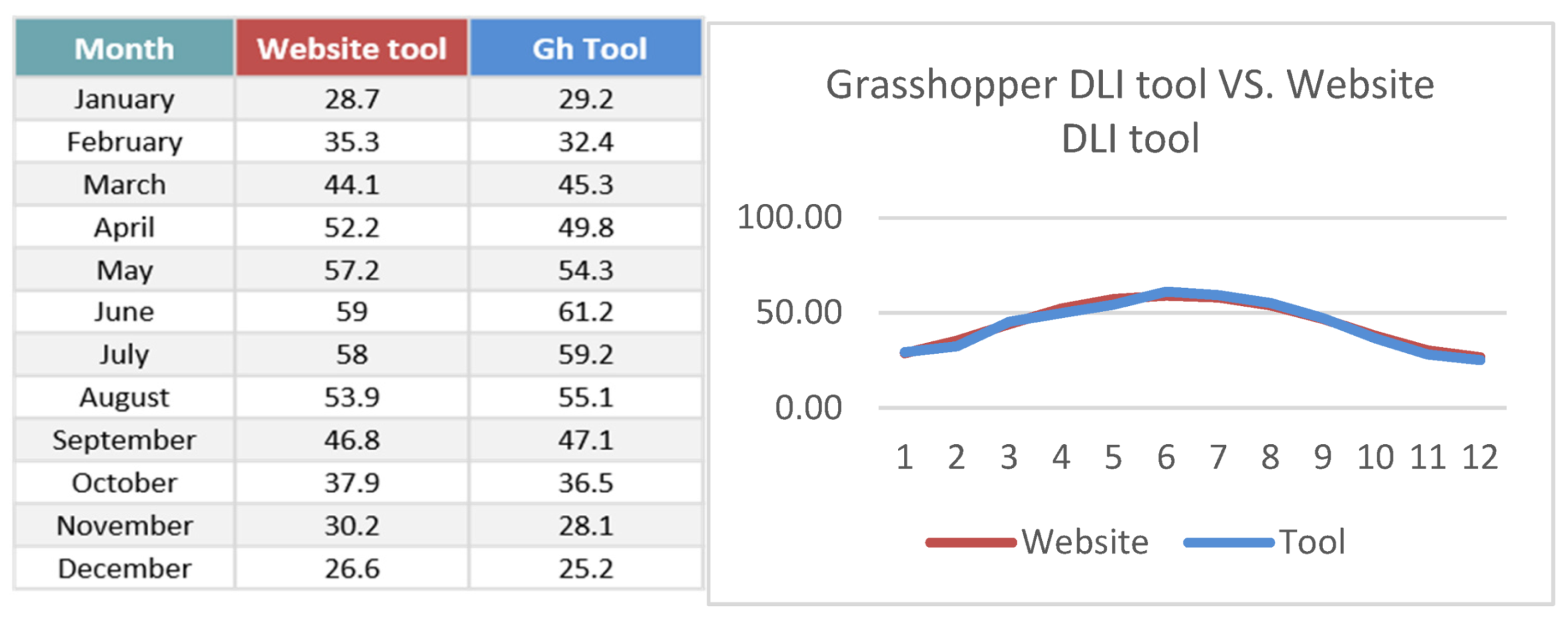
To get sure that the tool was working properly, a comparison between the website calculator results and the Grasshopper-designed tool results on roofs was conducted. The results were close with a difference of around 1.23%, which is mostly due to the different weather files that each tool used. According to that, the tool is validated and merged with the AGRI|gen\Analysis tool to be used to convert solar radiation results to DLI values (see Figure 17).
  • DLI values on different surfaces
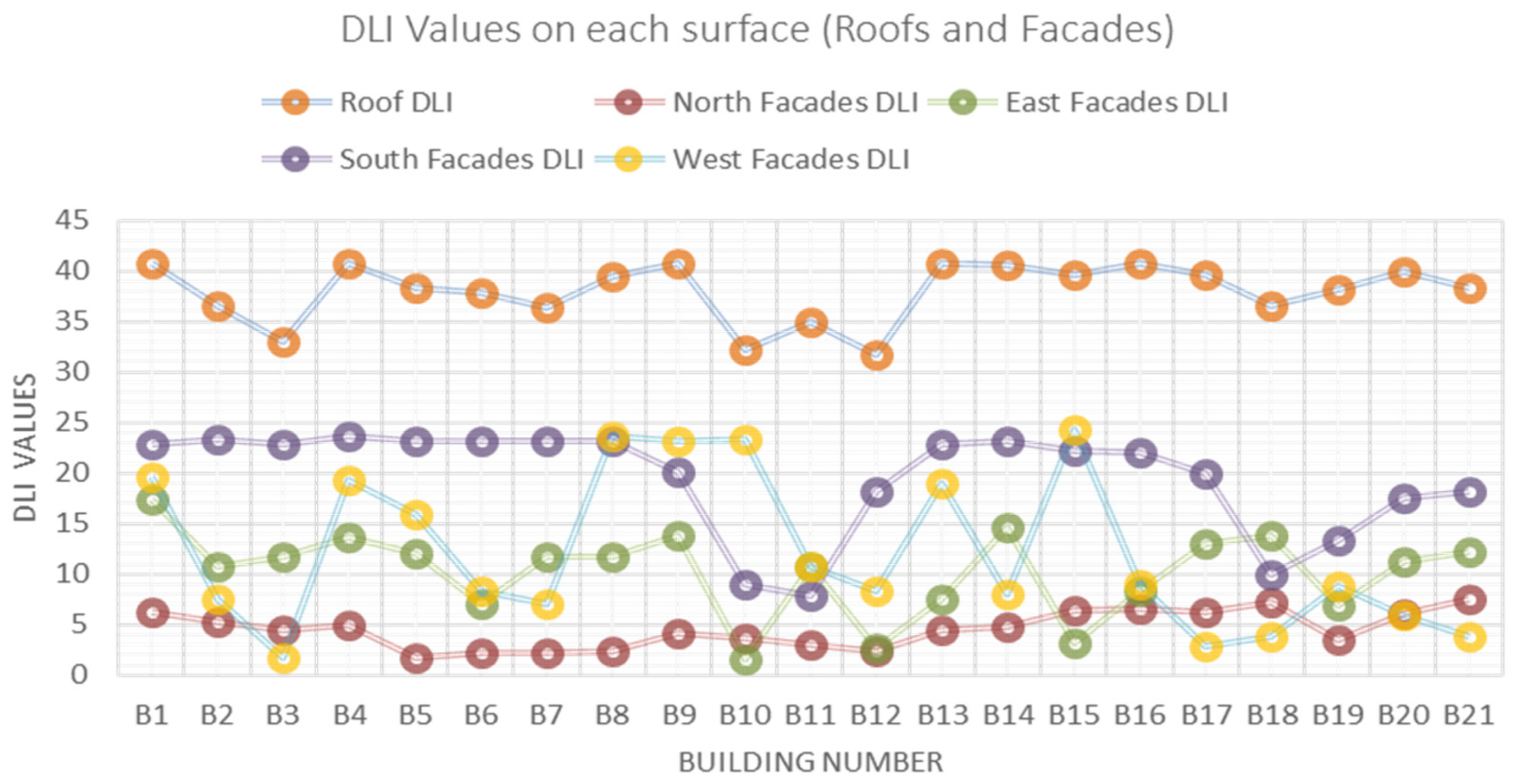
After successfully validating and merging the DLI tool with the AGRI|gen\Analysis tool, the next step was to use it to convert the previously calculated average solar radiation on each surface to DLI values. These results were then exported to an Excel sheet using the data tree structure previously described. Later on, to better understand the DLI distribution between the different surfaces (roof and facades) and which has higher farming than the others, a basic comparison was conducted as shown in the following Figure 18. In Figure 18, it was obvious that the roof had the highest DLI values, then followed by the South, West, and east elevations, respectively, while the north facade came least.

4.5.3. Best Crop for Each Surface (Decision Making)

Once the DLI values were generated, a specific algorithm was used to determine the most suitable crop for each facade. This algorithm takes into account the minimum DLI required for each crop and prioritizes crops that can thrive under higher DLI values, taking into consideration that having a higher DLI does not have a negative impact, instead, each additional DLI unit increases productivity by 1%. For example, if the DLI value on a certain surface is 17, then the AGRI|gen\Analysis tool would select herbs (15 DLI) as the nearest option available from the pre-selected crops, whereas if the DLI value was 30, the AGRI|gen\Analysis tool would choose peppers (25 DLI), which requires the highest DLI value among the crops. However, if the DLI value is lower than 10 DLI (below the minimum required for microgreens, which require 10 DLI), the AGRI|gen\Analysis tool would indicate “Poor DLI” for that surface, meaning that it would not be suitable for planting based on natural lighting alone. After that, the data was exported to the excel file using the same data tree structure.

4.5.4. Total Productivity

The AGRI|gen\Analysis tool utilized the results of the decision-making process to calculate the total productivity by multiplying the available area by the productivity of each crop. The AGRI|gen\Analysis tool provided a simple and efficient way to identify the best crops for each facade while taking into account the available natural lighting and maximizing the total productivity as shown in the following Table 6 and Table 7.

4.6. AGRI|gen\Analysis Tool Output and Findings

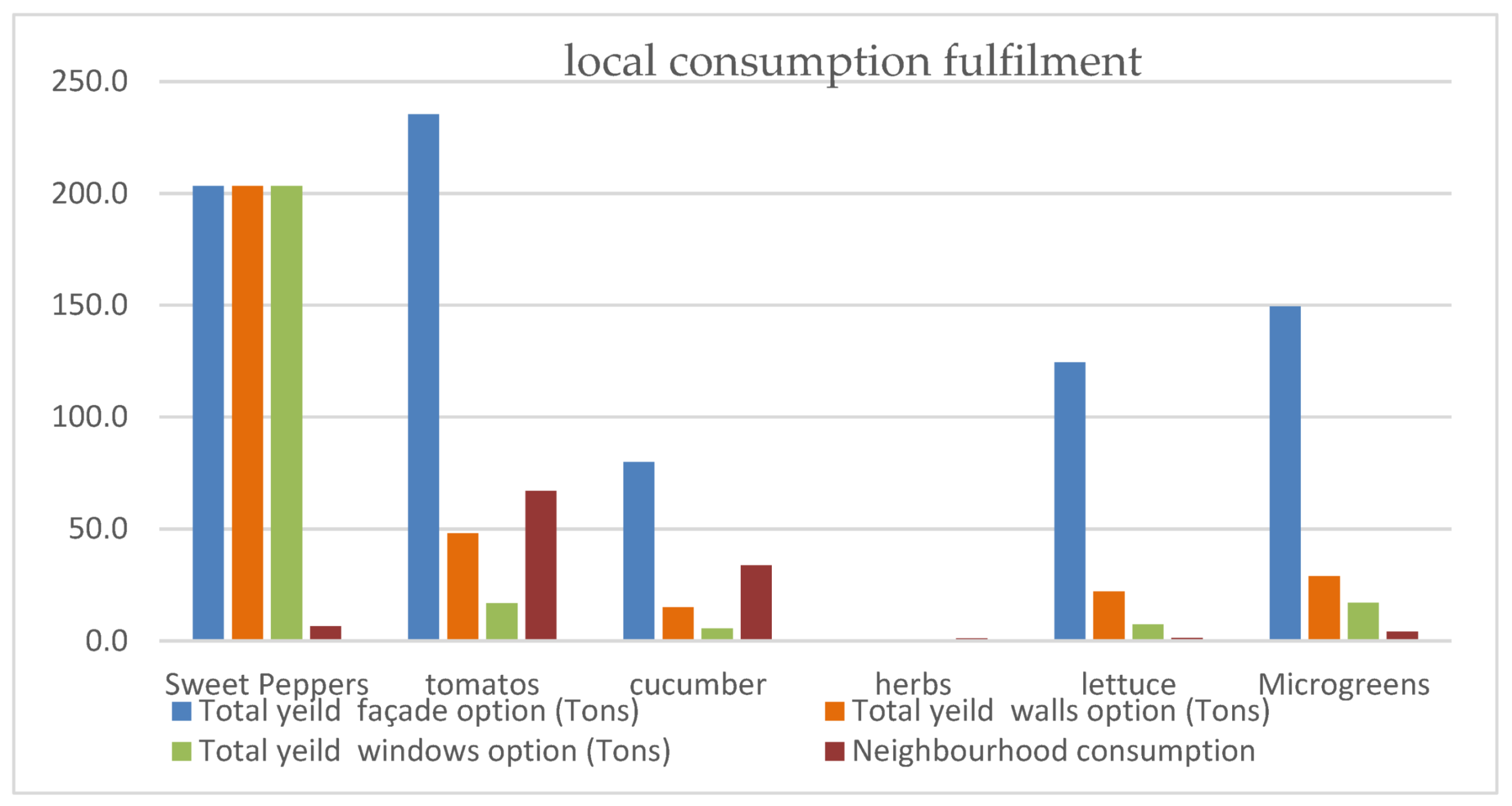
The last step in the AGRI|gen\Analysis tool was to compare the neighbourhood consumption and the total productivity of each option, and then visualize the results (see Table 8 and Figure 19). In terms of options, the most productive option for farming the facade is to farm the entire surface. This would yield the best results. In terms of productivity, option one would result in a production of tomatoes up to 3.5 times more than consumption. On the other hand, option two satisfies nearly 75% of the local demand for tomatoes and about half of their demand for cucumbers. This makes it a viable option, as it would require less intervention. It’s worth noting that according to the selection algorithm, all roof areas were utilized for farming sweet peppers, which explains why the three bars of sweet peppers remain unchanged across all three options. This highlights the potential of roof farming and merits further investigation in the future.
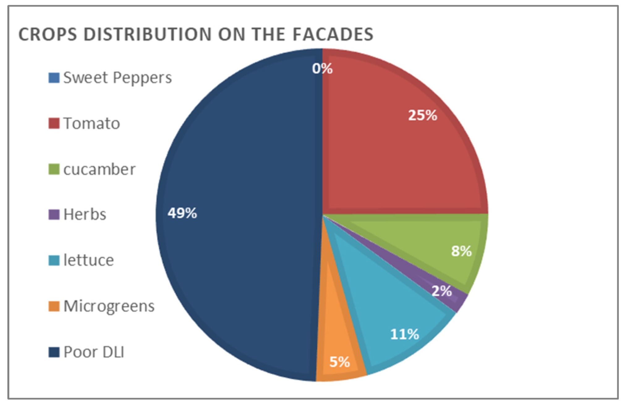
In terms of crop distribution, the distribution showed that roofs are best suited for high DLI plants like sweet peppers, while 25% of the facade areas were suitable for growing tomatoes. However, almost half of the facades were not appropriate for natural light-based farming as they had less than 10 DLI, indicating the need for supplementary lighting systems if these facades are to be used for farming. This is demonstrated in Figure 20.

5. The Design Process

5.1. Design Concept

5.1.1. Previous Related Work

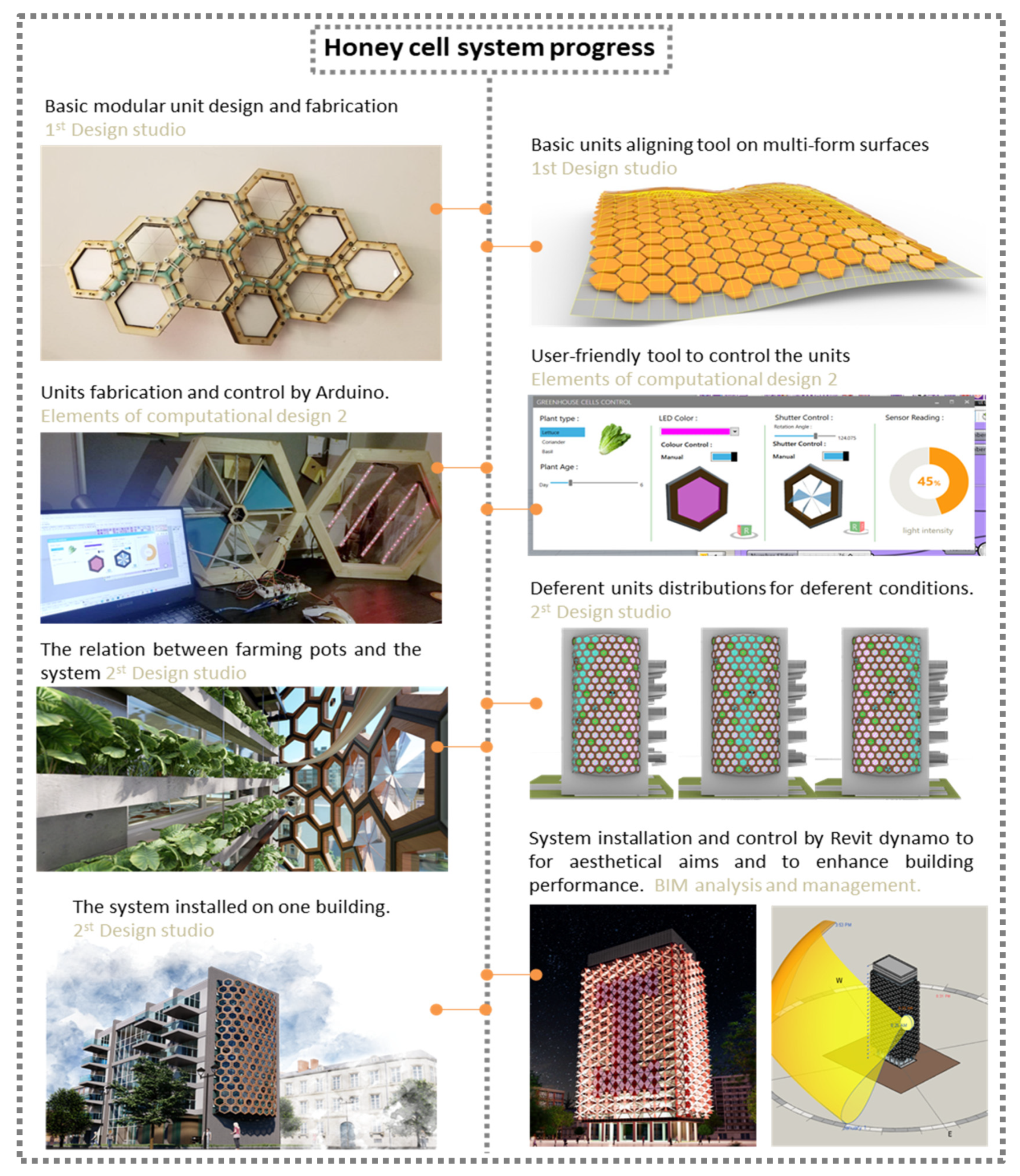
This AGRI|gen\Design tool was inspired by the researcher’s previous (group and individual) works in different modules within the MSc of Digital Architecture and Design at the University of Sheffield. During that a modular hexagonal unit joinery system was designed, units were fabricated, controlled by Arduino, and a modular adaptive greenhouse was implemented on a building facade and a roof as shown in the following Figure 21.

5.1.2. AGRI|gen\Design Tool Target

The focus of the researcher’s previous works was mainly centred around the design and construction of individual units, including the unit’s joinery system, limited to one facade and a roof. However, this study expands upon that by looking at the larger neighbourhood scale, taking into account productivity and cost considerations. The goal of the AGRI|gen\design tool is to build upon these previous works by utilizing the data collected from the AGRI|gen\Analysis to determine the distribution of the units across various facades. So, the AGRI|gen\Design tool will help calculate the required units, estimate costs, and study the potential distribution patterns. Additionally, it will provide virtual 3D images for the design, allowing for further examination of other aspects such as the human dimension in the future. Figure 22 shows the main inputs and outputs of the AGRI|gen\Design tool.

5.1.3. Units Definition

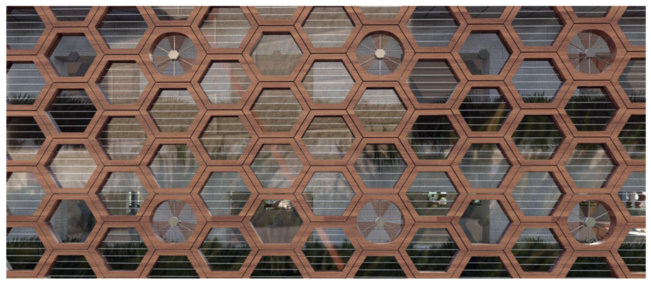
The goal of the modular units is to function as a comprehensive system to improve the growing environment for plants. For this reason, four types of units were selected: the LED unit, which provides additional light to increase DLI, made mostly of transparent high-tech lightweight plastic ETFE for maximum natural light transmission; the fan unit, used for plant and occupant ventilation to lower the temperature; the PV unit, which provides shading when needed and generates energy; and the sensor unit, which measures conditions and provides feedback to the system to adjust accordingly (see Figure 23).
All the units have the same frame, for this research the frame height was 1 m (which is one-third of the most used floor height in the neighbourhood); this will guarantee to have a repetitive pattern all over the facade height.

5.2. General AGRI|gen\Design Tool Algorithm

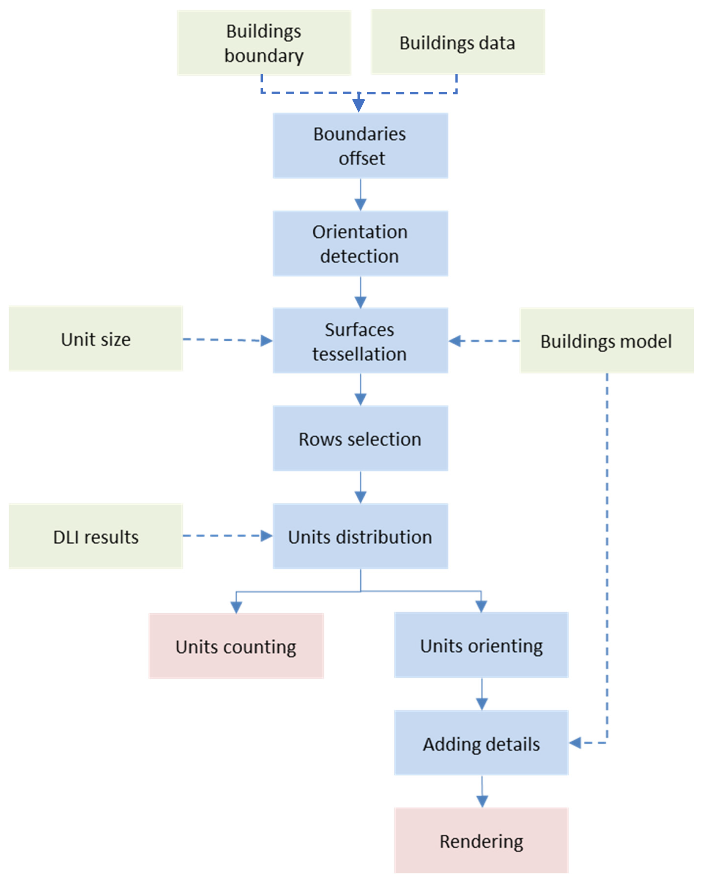
The following algorithm in Figure 24 explains the AGRI|gen\Design tool processes starting with the inputs (boundaries, model, and DLI values for the buildings), then the processes of; offsetting, tessellation, and units distribution, ending with unit counting which will help to estimate the system costs, as also units rendering which will help for further studies about the human perception for such system.

5.3. AGRI|gen\Design Tool Inputs

As previously mentioned, the inputs for the AGRI|gen\Design tool are; the buildings boundaries, buildings model, and DLI values on surfaces, all of these inputs were previously generated by the AGRI|gen\analysis tool. Furthermore, the modular used unit size should be defined, so in this research, as mentioned earlier the used unit height was 1 m to have a repetitive pattern all over the facade height.

5.4. Shell Modelling

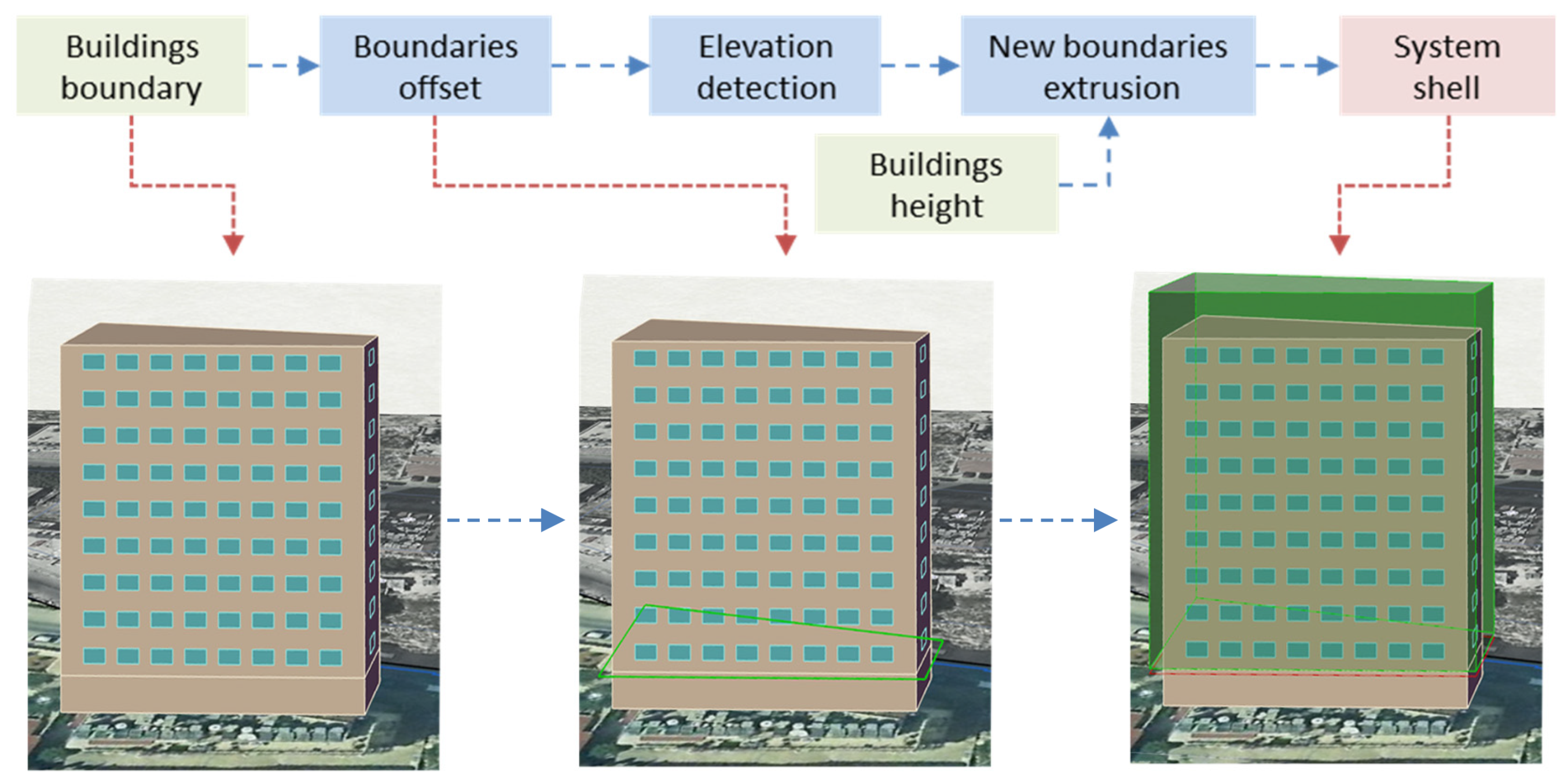
The first step in the AGRI|gen\Design tool was to establish a basic shell to distribute the units around it, this shell was created from the boundaries and data of the building using the following algorithm to get the following results in Figure 25.

5.5. Facade Tessellation

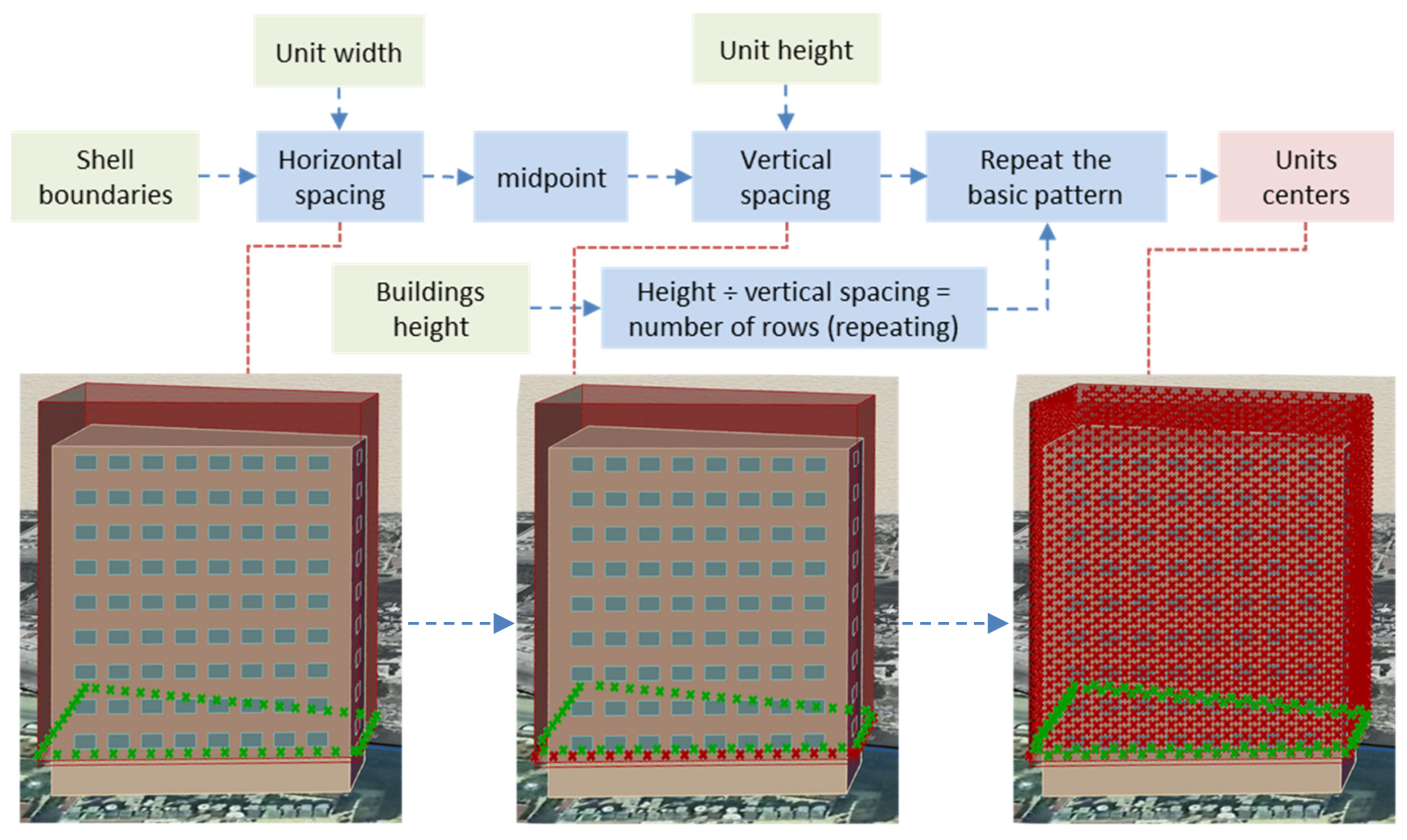
To place the hexagonal units on the shell a specific guiding pattern was needed, each point of this pattern represents the centre of one hexagonal unit. To do that pattern the following algorithm in Figure 26 was applied.
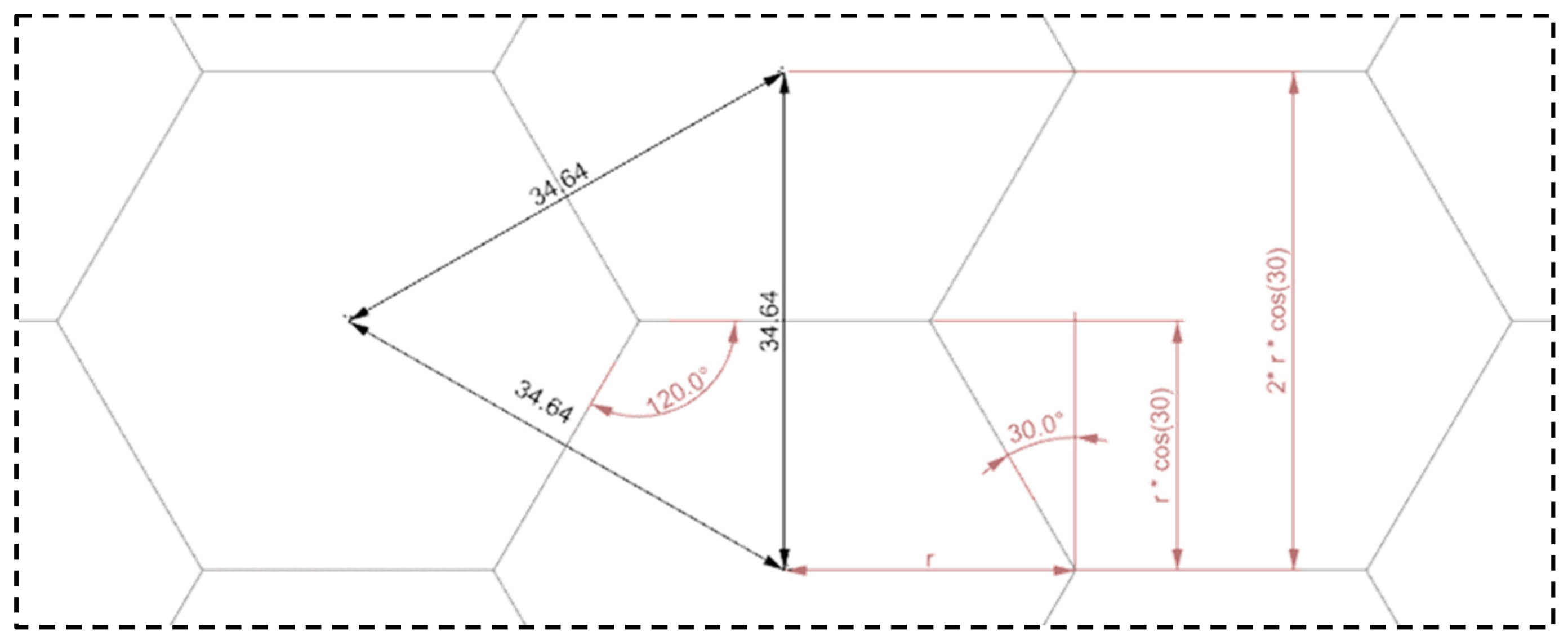
Moreover, to get the vertical and horizontal spacing values the following hexagonal tessellation equations were used see Figure 27.

5.6. Units Distribution

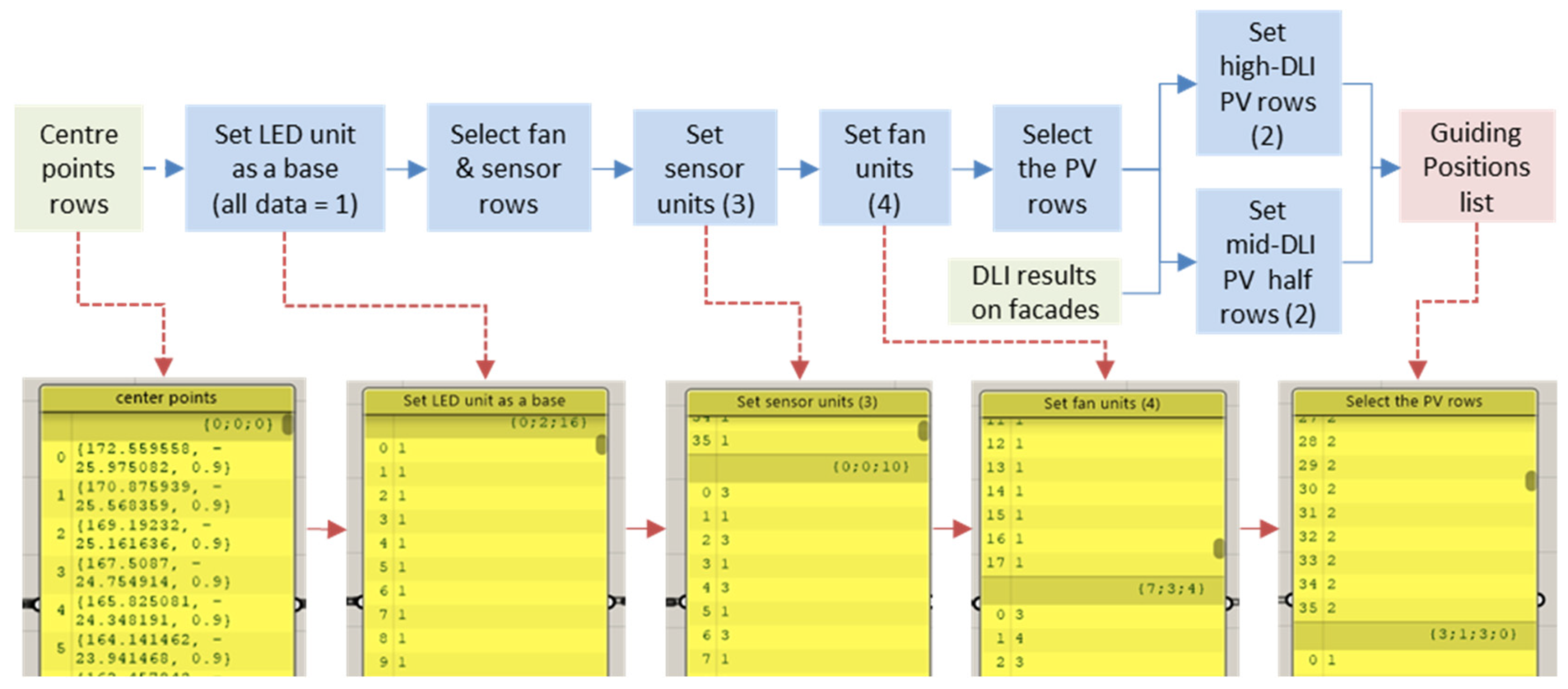
After generating the centre point of each unit on the façade, the AGRI|gen\Design tool did the following steps to put each unit type in its appropriate place (see Figure 28).

5.6.1. Rows Selection

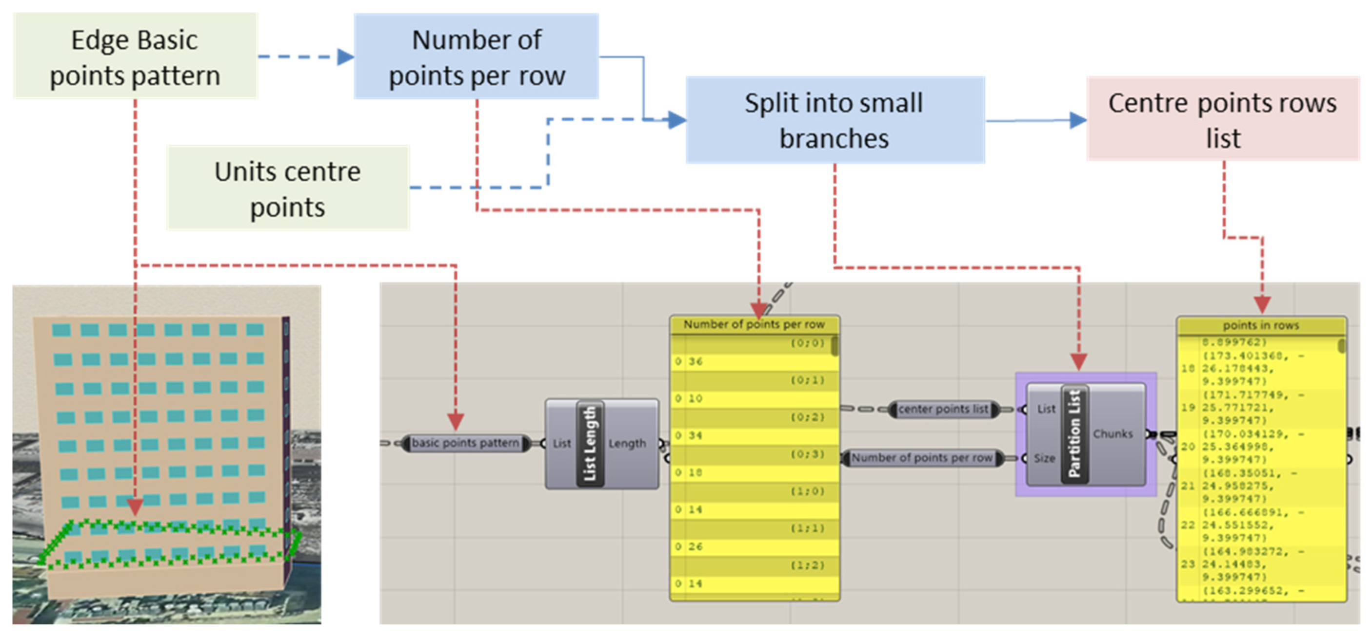
To be able to distribute the patterns repetitively with relation to each floor, the AGRI|gen\Design tool divided the total points on each facade into row lists; each row list has its branch number and represents a group of points that has almost the same level on the same surface. To do so, the following algorithm was used. See Figure 29.

5.6.2. Distribution Rules

To optimise the system (LED, PV, sensor, and fan), units were numbered (1,2,3,4) respectively and the following rules were set. See Figure 30.
  • Each facade is divided into equal rows; to have a repeatable pattern on each floor.
  • LED units should be the default unit for all point centres (to serve as a primary basis).
  • PV units should not be in front of windows; in order not to block the view and ventilation.
  • PV units should take a full row in high DLI facades, half a row in mid-DLI facades, and no rows in low DLI facades; as their main role is to provide shading (for the residents) and generate electricity.
  • Sensor and fan units should be placed at a fixed distance in the row (to be evenly distributed).
  • Technically, to implement those rules the following algorithm was used (see Figure 30).

5.6.3. Data Tree Structure

Inspired by the AGRI|gen\analysis tool, the AGRI|gen\Design tool used the same tree structure but with more complexity, as the tree has 5 levels of branches starting with the main neighbourhood branch and ending with the centre points rows lists. This complexity required advanced data tree-managing techniques such as trimming and grafting. Figure 31.

5.6.4. Units Orientation

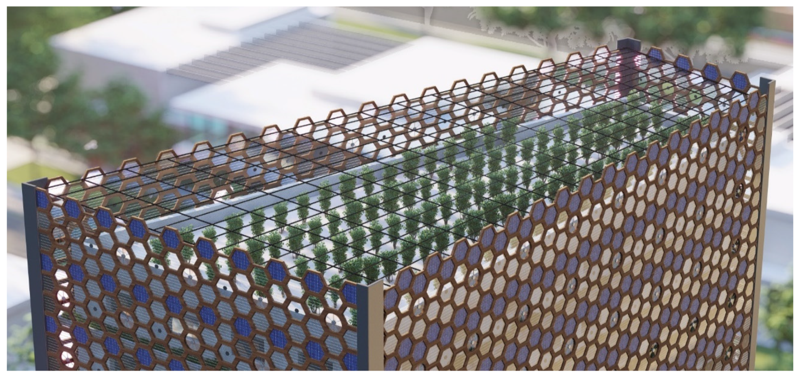
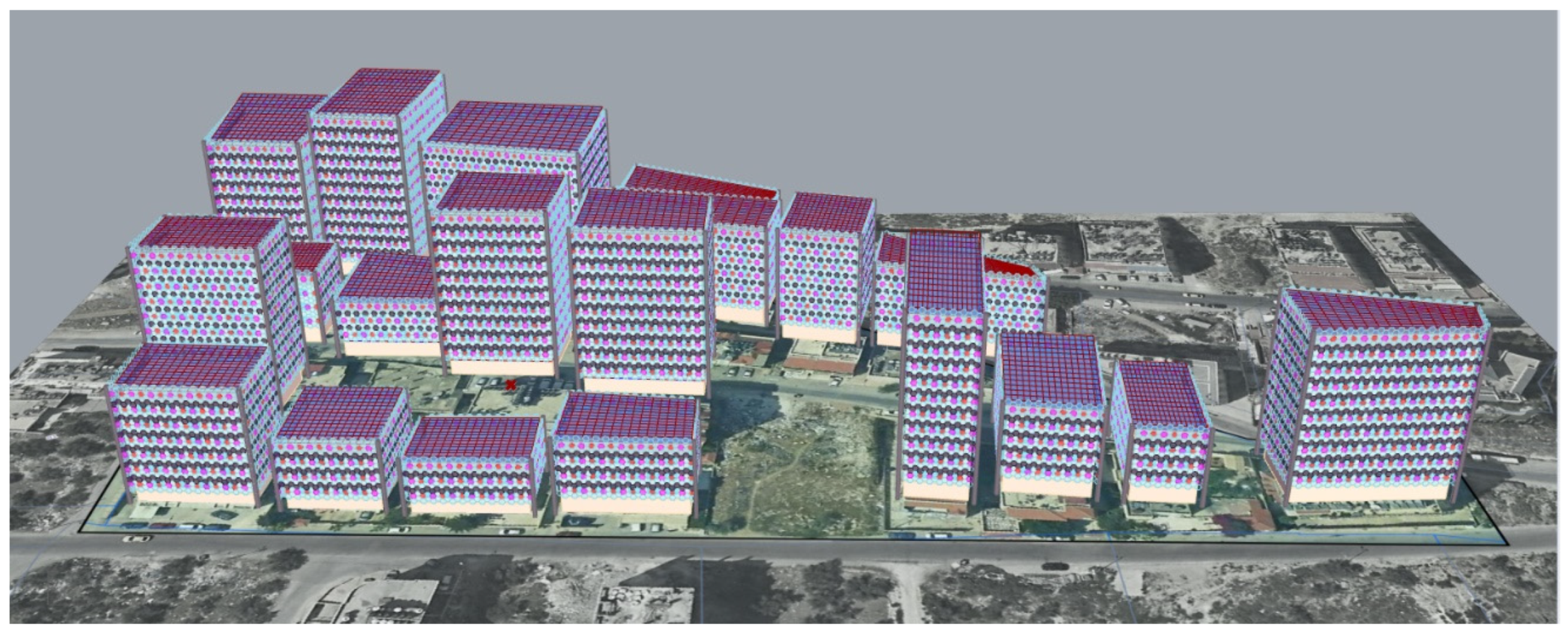
After generating the guiding units’ positions list, the following algorithm was used to place the modular units in the right positions, to get the following results on the entire neighbourhood (see Figure 32 and Figure 33).

5.7. Roof Design

Since the roof gets significantly more natural light than the facades the AGRI|gen\Design tool did not use the hexagonal modular units for the roof ceiling design. Rather than that it increased the height of the surrounding facades system to cover the roof walls and did a basic rectangular ceiling design that adapts to each building’s boundaries and has a minimum slope towards the south to drainage water and provides PV potential. To do so the following algorithm was used in Figure 34.

5.8. Final Results Analysis

According to the targets of AGRI|gen\Design tool, the results study focused on the following main parts:

5.8.1. Units Count and Costs

Using the list length function in Grasshopper the count of used units was retrieved after those unit percentages were measured. To predict the system costs, each unit cost was estimated and then multiplied by its count as clarified below (see Table 9 and Figure 35). Furthermore, based on those results the average unit cost is about $41.75, while each squire meter needs 1.33 units, this means that the system (without the planters and structure) costs about $55.2\m2 which is less than 20% of the average cost of land in Nablus city neighbourhoods ($282\m2) [61].

5.8.2. Facade Patterns

According to the used distribution algorithm, facades were classified to high, mid, and low DLI levels, as a result, there were three main facade patterns as shown in the following Figure 36, having different patterns can reduce the monotony in the neighbourhood (see Figure 36).

5.8.3. Visualisation

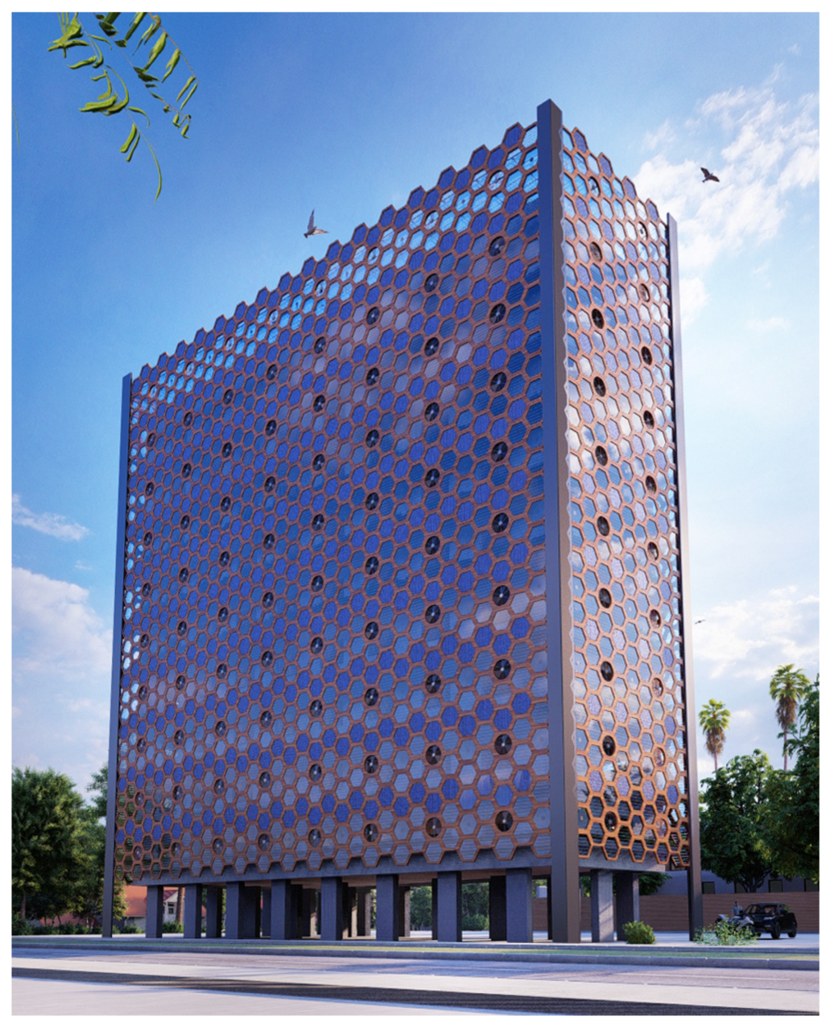
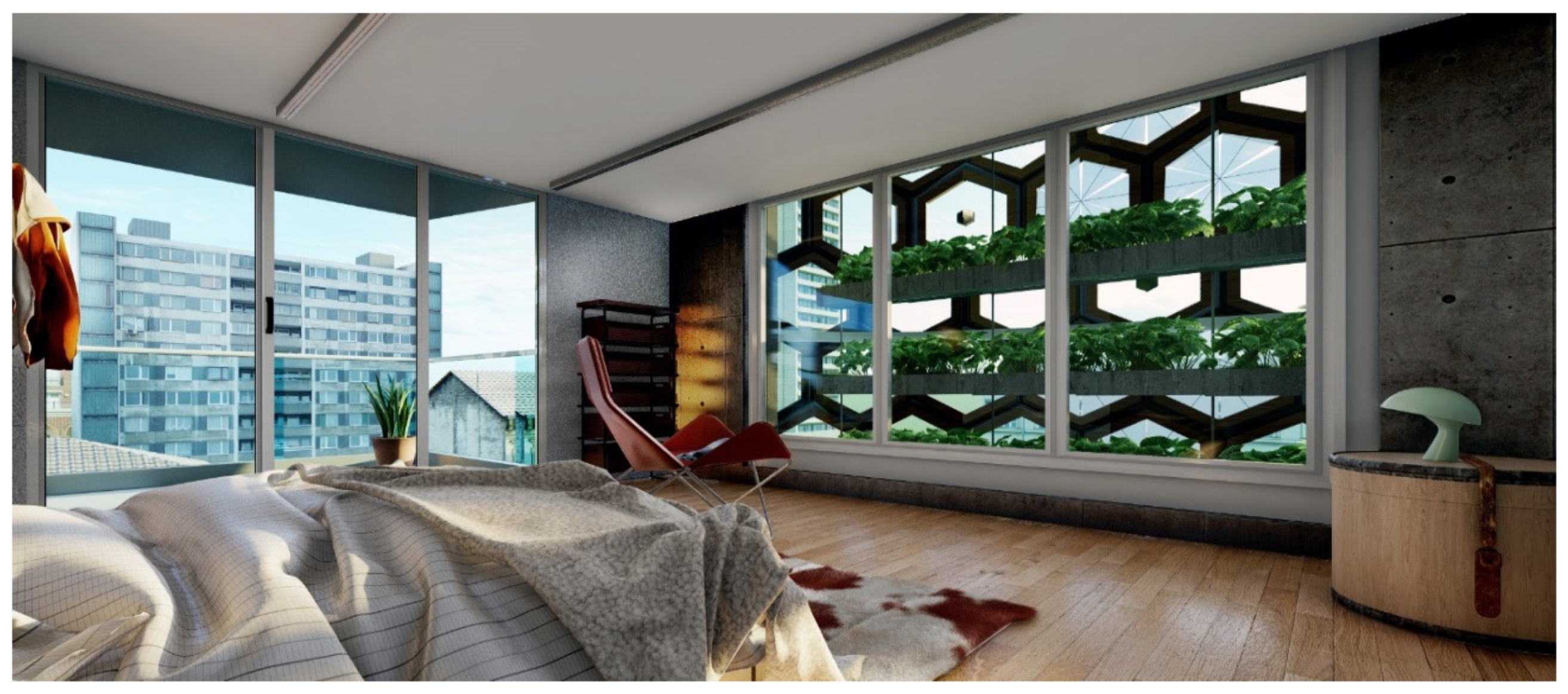
Finally, based on the AGRI|gen\Design tool 3d model output, some better-quality renders were done, those renders can be used to study the human acceptance of such systems, as to do further studies on patterns and aesthetical dimensions (see Figure 37, Figure 38, Figure 39, Figure 40, Figure 41, Figure 42 and Figure 43).

6. Conclusions and Recommendations

6.1. Conclusions

This research was conducted to try to answer two main questions; “How much a facades and roof farming system can produce to fulfil the local needs on a neighbourhood scale?” and “how much could such a system cost?”. To answer those questions, an AGRI|gen analysis and design tools were developed and implemented in a neighbourhood in Nablus city, and the main results were;
Almost half of the facades in the neighbourhood got less than 10 DLI making them not suitable for natural light-based farming, moreover, almost 25% of the facades were suitable to farm tomatoes and about 33% were suitable to farm cucumbers in the selected neighbourhood.
The farming system on facades, walls, and windows options can fulfil about 351%, 71%, and 25% respectively of the annual local neighbourhood consumption of tomatoes, as also about 237%, 44%, and 16% of cucumber consumption in addition to other crops on facades at the same time. All those results are for daylight-based farming (almost half of the area of the facade only) so they have the potential to double if the supplementary light system is used. Additionally, farming on roofs can annually produce about 203 tons of sweet peppers which is 315 times more than the 6.5 tons consumption in the neighbourhood.
Facade farming options (facades, walls, and windows) can provide about (28,500, 5400, and 2200 m2) respectively of farming areas in the selected neighbourhood, half of them are suitable for daylight-based farming while the other needs a supplementary lighting system. The entire facade system needs about 40,824 modular units of which 73.3%, 10.1%, 8.7%, and 8% of them are LED, PV, Sensor, and fan units respectively. The average unit cost is about $41.75 which makes a system cost about $55.2\m2 which is 20% less than the average price of a squire meter of land in the same neighbourhoods.
In terms of costs, the total maximum facade system is expected to cost about $1.7M (not including the hydroponic systems) and can provide about 28,500 m2 of farming areas. The proposed vertical farm in the same city (mentioned in the literature review) is expected to need 3000 m2 of empty land and cost about $14M (not including the hydroponic systems and the land price) and can provide up to 12,000 m2 of farming areas. This shows how much potential the farming facade system has compared to vertical farming in terms of land needs and costs.
The detailed analysis of the distribution patterns and the Daily Light Integral (DLI) on each facade showed how the geographical location and facades’ orientation can have a direct impact on the unit types patterns, the farming possibility, and crop options in vertical farming. For example, facades in areas with high sun exposure are good for growing high DLI-demanding crops such as tomatoes and peppers, while other facades with low amounts of DLI are suitable for growing leafy greens or in some cases not suitable for daylight-based farming. Additionally, the availability and costs of energy can affect the cost and feasibility of vertical farming. For example; Specialized lighting systems may be required to provide adequate light for the crops in areas with low light availability, which can increase the operating cost. In regions with high energy costs, the cost of lighting, climate control, and other operational expenses can also increase significantly, further impacting the feasibility of vertical farming. Therefore, it is essential to consider these factors when designing vertical farming operations to optimize feasibility and minimize the costs of the farming process. This can be done by carefully analyzing the geographical location, climate, the orientation of the facades, and the availability of light and energy and selecting appropriate crops, unit types, and farming practices to reduce operational expenses and increase yields as done in this research.
Even though hydroponic farming can save up to 90% of watering compared to traditional farming [36], the availability of water and farming technology is still a limit for such projects, especially in areas with water shortages or under drought. As a result water saving methods should be further studied, such as using treated grey water which is recycled water from sources such as sinks, and showers. This approach can not only save freshwater resources but also provides a cost-effective way of irrigation for hydroponic systems. Further research into the use of such treated grey water in hydroponic farming can help expand the application of this technology in water-limited areas.

6.2. Recommendations

Further research into the potential of facade farming systems should be done, including looking into possible structural solutions for the system and looking into the aesthetic possibilities of employing the system to relieve monotony in building elevations. Furthermore, it is critical to investigate the social acceptance of such a system in various communities. Further study is also needed to uncover more crops, such as herbs, that can be cultivated utilizing façade farming. To promote the façade farming culture, it is critical to educate the people about the benefits of this style of farming at a young age, for example, by introducing it into school curricula. Furthermore, it is recommended to consider incorporating facade farming systems into the early stages of architectural designs to save on expected costs. In order to support the implementation of these systems, more field testing studies for small-scale farming systems on existing buildings and in neighbourhoods should be conducted. Finally, municipalities and governments should provide encouraging building licenses and rules to support the use of facade farming systems.

Author Contributions

Conceptualization, I.G. and R.M.; methodology, M.D. and I.G. software, I.G.; validation, I.G.; formal analysis, I.G.; investigation, I.G.; resources, I.G. and R.M.; data curation, I.G.; writing—original draft preparation, I.G. and R.M.; writing—review and editing, M.D.; visualisation, I.G.; funding acquisition, I.G. and M.D. All authors have read and agreed to the published version of the manuscript.

Funding

This publication was funded by the German Research Foundation (DFG) grant “Open Access Publication Funding/2023-2024/University of Stuttgart” (512689491). This research was partially funded by the Deutsche Forschungsgemeinschaft (DFG, German Research Foundation) under Germany’s Excellence Strategy—EXC 2120/1—390831618. The scholar’s master’s study has been funded by the UK Government as part of the Chevening Scholarships 2019/20.

Acknowledgments

Thank also goes to the British government and Chevening scholarship for their financial sponsorship for the scholar’s master’s study, and to An-Najah National University for their collaboration and support.

Conflicts of Interest

The authors declare no conflict of interest.

References

  1. Lorenz, K.; Lal, R. Carbon Sequestration in Agricultural Ecosystems, 1st ed.; Springer: Cham, Switzerland, 2018. [Google Scholar] [CrossRef]
  2. Despommier, D. The Vertical Farm: Feeding the World in the 21st Century, 1st ed.; Macmillan: New York, NY, USA, 2010. [Google Scholar]
  3. Despommier, D. Vertical Farms in Horticulture BT-Encyclopedia of Food and Agricultural Ethics; Thompson, P.B., Kaplan, D.M., Eds.; Springer: Dordrecht, The Netherlands, 2014; pp. 1791–1799. [Google Scholar] [CrossRef]
  4. Haworth, T. How Much Does Vertical Farming Cost? (2022 Start-Ups Costs & Profit Return). Available online: https://cambridgehok.co.uk/news/how-much-does-vertical-farming-cost (accessed on 25 August 2022).
  5. Bustami, R.A.; Belusko, M.; Ward, J.; Beecham, S. Vertical greenery systems: A systematic review of research trends. Build. Environ. 2018, 146, 226–237. [Google Scholar] [CrossRef]
  6. Tablada, A.; Kosorić, V.; Huang, H.; Chaplin, I.K.; Lau, S.K.; Yuan, C.; Lau, S.S.Y. Design optimisation of productive Façades: Integrating photovoltaic and farming systems at the tropical technologies laboratory. Sustainability 2018, 10, 3762. [Google Scholar] [CrossRef] [Green Version]
  7. Jabi, W. Parametric Design for Architecture; Laurence King: London, UK, 2013. [Google Scholar]
  8. Bradley, S. The Benefits of Modular Design—Vanseo Design. Available online: https://vanseodesign.com/web-design/modular-benefits/ (accessed on 31 August 2022).
  9. Palestinian Central Bureau of Statistics. Palestine Statistical Yearbook 2017; Palestinian Central Bureau of Statistics: Ramallah, Palestine, 2017.
  10. Robert McNeel and Associates. Rhino Grasshopper 7.0; Robert McNeel and Associates: Seattle, WA, USA, 2020. [Google Scholar]
  11. Roudsari, M.S.; Mackey, C. Ladybugtools 0.0.69; Ladybug Tools LLC: Fairfax, VA, USA, 2017. [Google Scholar]
  12. Sevaldson, B. Discussions & Movements in Design Research: A systems approach to practice research in design. Form Akad. 2010, 3, 8–35. [Google Scholar] [CrossRef] [Green Version]
  13. Morrison, A.; Sevaldson, B. Getting Going Research by Design. FORMakademisk 2010, 3, 1–7. [Google Scholar] [CrossRef]
  14. Davidová, M. Systemic Approach to Architectural Performance: The Media Mix in the Creative Design Process. FormAkademisk-Res. J. Des. Des. Educ. 2017, 10, 1–25. [Google Scholar] [CrossRef]
  15. Schön, D.A. The Reflective Practitioner: How Professionals Think in Action; Basic Books: London, UK, 1992. [Google Scholar]
  16. Cross, N. Design Thinking: Understanding How Designers Think and Work; Berg Publishers: Oxford, UK, 2011. [Google Scholar]
  17. FAO. Proceedings of the Expert Meeting on How to Feed the World in 2050; FAO: Rome, Italy, 2009; p. 35. [Google Scholar]
  18. Vermeulen, S.J.; Campbell, B.M.; Ingram, J.S.I. Climate change and food systems. Annu. Rev. Environ. Resour. 2012, 37, 195–222. [Google Scholar] [CrossRef] [Green Version]
  19. Karimi, L.; Ghassemi, A. Rural Desalination. In A Multidisciplinary Introduction to Desalination; River Publishers: New York, NY, USA, 2022; pp. 531–558. [Google Scholar]
  20. Ungureanu, N.; Vlăduț, V.; Voicu, G. Water scarcity and wastewater reuse in crop irrigation. Sustainability 2020, 12, 9055. [Google Scholar] [CrossRef]
  21. Dankova, R. Agriculture Holds the Key to Tackling Water Scarcity. 2016. Available online: https://blogs.worldbank.org/water/agriculture-holds-key-tackling-water-scarcity (accessed on 31 August 2022).
  22. Ritchie, H.; Roser, M. Urbanization—Our World Data. Available online: https://ourworldindata.org/urbanization (accessed on 24 October 2022).
  23. Nadal, A.; Cerón Palma, I.; Cuerva Contreras, E.; Gabarrell Durany, X.; Josa Garcia-Tornel, A.; Rieradevall Pons, J.; Pons Valladares, O.; Sanyé-Mengual, E. Urban agriculture in the framework of sustainable urbanism. Temes Disseny 2015, 31, 92–103. [Google Scholar]
  24. Campos Mühlenhoff, S. Food System Transformations: Social Movements, Local Economies, Collaborative Networks; Cambridge University Press: Cambridge, UK, 2022; Volume 37. [Google Scholar] [CrossRef]
  25. Armstrong, D. A survey of community gardens in upstate New York: Implications for health promotion and community development. Health Place 2000, 6, 319–327. [Google Scholar] [CrossRef] [PubMed]
  26. Pirog, R.; Van Pelt, T.; Enshayan, K.; Cook, E. Food, Fuel, and Freeways: An Iowa perspective on how far food travels, fuel usage, and greenhouse gas emissions. Leopold Cent. Sustain. Agric. 2001, 209, 37. [Google Scholar]
  27. What Is Urban Agriculture? Types and Benefits of Urban Agriculture—Conserve Energy Future n.d. Available online: https://www.conserve-energy-future.com/types-and-benefits-urban-agriculture.php (accessed on 31 August 2022).
  28. Taib, N.; Prihatmanti, R. Optimising balcony for green spaces: Application of edible biofaçade on urban high-rise setting. Plan. MALAYSIA 2018, 16, 98–109. [Google Scholar] [CrossRef]
  29. Shamshiri, R.R.; Kalantari, F.; Ting, K.C.; Thorp, K.R.; Hameed, I.A.; Weltzien, C.; Ahmad, D.; Shad, Z.M. Advances in greenhouse automation and controlled environment agriculture: A transition to plant factories and urban agriculture. Int. J. Agric. Biol. Eng. 2018, 11, 1–12. [Google Scholar] [CrossRef]
  30. Derbas, G. The Planning and Design of Vertical farms: Prospects for Urban Farming in Palestine. Master Dissertation, The University of Jordan, Amman, Jordan, 2012. [Google Scholar]
  31. Safikhani, T.; Abdullah, A.M.; Ossen, D.R.; Baharvand, M. A review of energy characteristic of vertical greenery systems. Renew. Sustain. Energy Rev. 2014, 40, 450–462. [Google Scholar] [CrossRef]
  32. Ottelé, M. Vertical greening systems and the effect on air flow and temperature on the building envelope. Build. Environ. 2011, 46, 2287–2294. [Google Scholar]
  33. Perini, K.; Ottelé, M.; Haas, E.M.; Raiteri, R. Vertical greening systems, a process tree for green façades and living walls. Urban Ecosyst. 2013, 16, 265–277. [Google Scholar] [CrossRef]
  34. Manso, M.; Castro-Gomes, J. Green wall systems: A review of their characteristics. Renew. Sustain. Energy Rev. 2015, 41, 863–871. [Google Scholar] [CrossRef]
  35. Walch, J. Hydroponic-Urban-Gardening Hydroponic: Hydroponics—Optimal Growing Conditions n.d. Available online: https://www.hydroponic-urban-gardening.com/hydroponics-guide/hydroponics-optimal-growing-conditions/?L=1 (accessed on 19 August 2020).
  36. Eden Green Technology 10 Benefits of Hydroponics|Eden Green n.d. Available online: https://www.edengreen.com/blog-collection/benefits-of-hydroponics (accessed on 19 November 2022).
  37. Ćavar Zeljković, S.; Aucique-Perez, C.E.; Štefelová, N.; De Diego, N. Optimizing growing conditions for hydroponic farming of selected medicinal and aromatic plants. Food Chem. 2022, 375, 131845. [Google Scholar] [CrossRef] [PubMed]
  38. McCree, K.J. Photosynthetically Active Radiation BT—Physiological Plant Ecology I: Responses to the Physical Environment; Lange, O.L., Nobel, P.S., Osmond, C.B., Ziegler, H., Eds.; Springer: Berlin/Heidelberg, Germany, 1981; pp. 41–55. [Google Scholar] [CrossRef]
  39. DLI (Daily Light Integral) Chart—Understand Your Plants’ PPFD & Phot—LEDTonic n.d. Available online: https://www.ledtonic.com/blogs/guides/dli-daily-light-integral-chart-understand-your-plants-ppfd-photoperiod-requirements (accessed on 5 October 2022).
  40. Palliwal, A.; Song, S.; Tan, H.T.W.; Biljecki, F. 3D city models for urban farming site identification in buildings. Comput. Environ. Urban Syst. 2021, 86, 101584. [Google Scholar] [CrossRef]
  41. Mary wickison 25 of the Best Plants for Indoor Hydroponic Gardens—Dengarden. 2022. Available online: https://dengarden.com/gardening/indoor-hydroponic-garden (accessed on 19 November 2022).
  42. Day, M. Rhino Grasshopper—AEC Magazine; X3DMedia: London, UK, 2009; pp. 49–56. [Google Scholar]
  43. Shi, X.; Yang, W. Performance-driven architectural design and optimization technique from a perspective of architects. Autom. Constr. 2013, 32, 125–135. [Google Scholar] [CrossRef]
  44. Grasshopper 3D—c—We Think Forward n.d. Available online: http://www.sentragrafika.com/grasshopper-and-learning-session.html (accessed on 24 October 2022).
  45. UN Habitat. National Report on Housing and Sustainable Urban Development; UN Habitat: Ramallah, Palestine, 2014. [Google Scholar]
  46. Abdelnour, S.; Agha, Z.; Baconi, T.; Dajani, M.; Kattan, V.; Sansour, V.; Tartir, A.; Zurayk, R. Focus On: Palestine’s Natural Resources—Al-Shabaka. Available online: https://al-shabaka.org/focuses/focus-on-palestines-natural-resources/ (accessed on 31 August 2022).
  47. Palestine GDP from Agriculture Forestry and Fishing—2022 Data—2023 Forecast. Available online: https://tradingeconomics.com/palestine/gdp-from-agriculture (accessed on 18 November 2022).
  48. Ministry of Foreign Affairs of the Netherlands. Climate Change Profile: Palestinian Territories; Ministry of Foreign Affairs of the Netherlands: Rotterdam, The Netherlands, 2018.
  49. Khader, A.; Martin, R.S. Use of Low-Cost Ambient Particulate Sensors in Nablus, Palestine with Application to the Assessment of Regional Dust Storms. Atmosphere 2019, 10, 539. [Google Scholar] [CrossRef] [Green Version]
  50. Nablus Municipality. Available online: http://nablus.org/index.php/en/nablus-city (accessed on 3 September 2020).
  51. An-Najah National University An-Najah National University: Nablus City. An-Najah Natl Univ 2022. Available online: https://www.najah.edu/en/about/history-and-traditions/nablus-city/ (accessed on 12 February 2023).
  52. Nablus Climate, Weather by Month, Average Temperature (Palestinian Territories)—Weather Spark. Available online: https://weatherspark.com/y/98966/Average-Weather-in-Nablus-Palestinian-Territories-Year-Round (accessed on 18 November 2022).
  53. Geomolg Geospatial Web Mapping Application In Palestine n.d. Available online: https://geomolg.ps/ (accessed on 10 August 2022).
  54. Marcelis, L.F.M.; Broekhuijsen, A.G.M.; Meinen, E.; Nijs, E.M.F.M.; Raaphorst, M.G.M. Quantification of the growth response to light quantity of greenhouse grown crops. In Proceedings of the Acta Horticulturae, Lillehammer, Norway, 21–24 June 2005; International Society for Horticultural Science (ISHS): Leuven, Belgium, 2006; pp. 97–104. [Google Scholar] [CrossRef]
  55. ASHRAE. 2015 ASHRAE HANDBOOK; ASHRAE: Atlanta, GA, USA, 2015. [Google Scholar]
  56. Climate.Onebuilding.org n.d. Available online: https://climate.onebuilding.org (accessed on 31 August 2022).
  57. WEATHER DATA|EnergyPlus n.d. Available online: https://energyplus.net/weather (accessed on 12 September 2022).
  58. Living Standards in the Palestinian Territory Expenditure, Consumption, Poverty, 2011; Palestinian Central Bureau of Statistics: Ramallah, Palestine, 2011.
  59. DLI Calculator—Agritecture n.d. Available online: https://www.agritecture.com/dli-calculator (accessed on 31 August 2022).
  60. Van Iersel, M. Can I Convert PAR (Photo Active Radiation) Value of Micro Mole/M2/S to Solar Radiation in Watt/m2? 2017. Available online: https://www.researchgate.net/post/Can-I-convert-PAR-photo-active-radiation-value-of-micro-mole-M2-S-to-Solar-radiation-in-Watt-m2 (accessed on 22 November 2022).
  61. Reem Abu-Laban What Are the Differences in the Prices of a Dunum of Land between the Palestinian Governorates? Aliqtisadi n.d. Available online: https://www.aliqtisadi.ps/article/5255/ما-هي-الاختلافات-في-أسعار-دونم-الأرض-بين-المحافظات-الفلسطينية؟ (accessed on 31 August 2022).
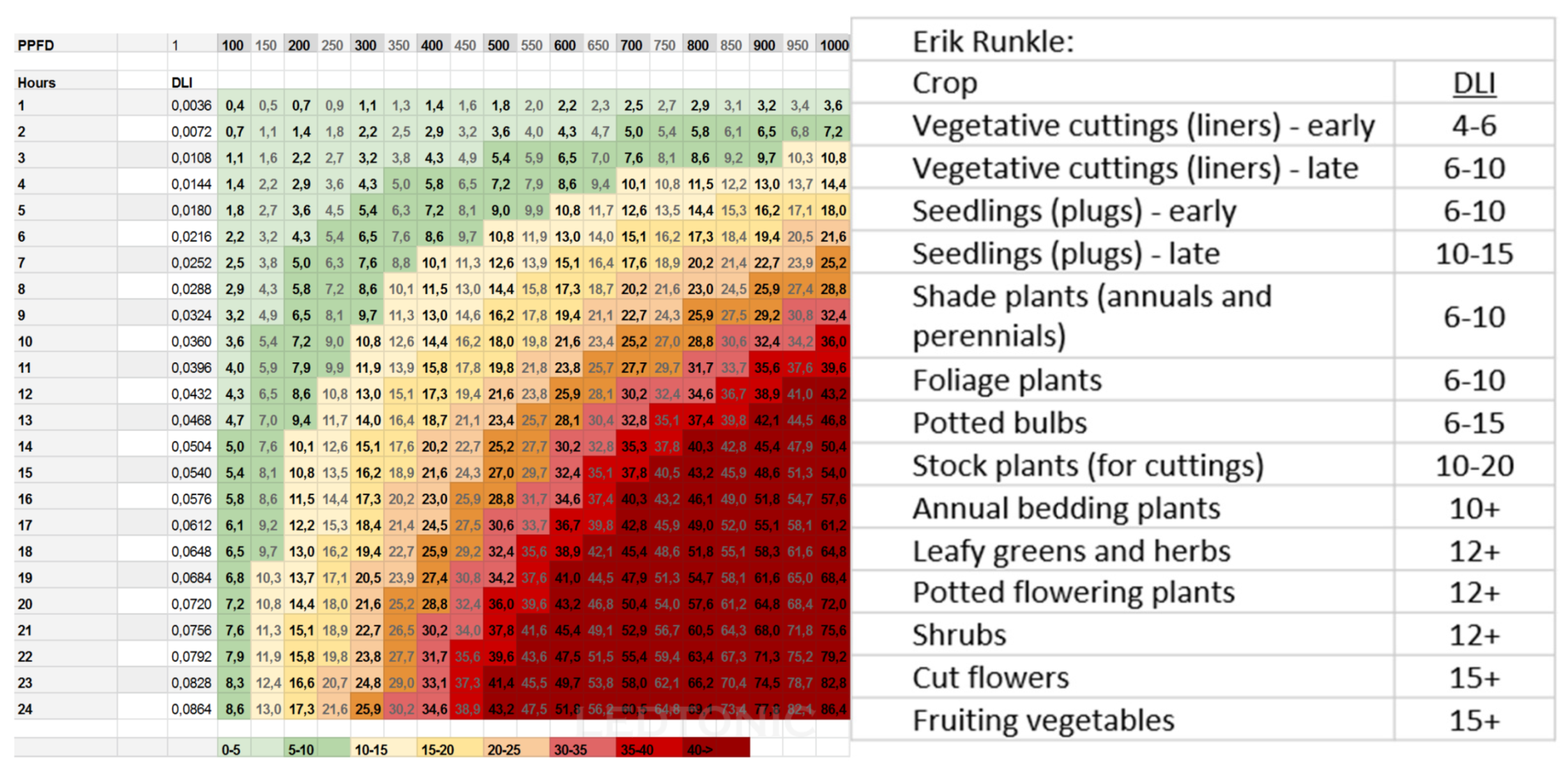
Figure 1. The following figure summarizes the DLI for different PPFD values to duration time and the needed DLI values for different crops [39] (source and with the courtesy of LEDTonic team).
Sustainability 15 05284 g001
Figure 2. Palestinian GDP From Agriculture (USD Million) (Reprinted with permission from Trading Economics [47]. 2022).
Sustainability 15 05284 g002
Figure 3. Nablus master plan [49] (source Khader and Martin, 2019 with the courtesy of A. Khader).
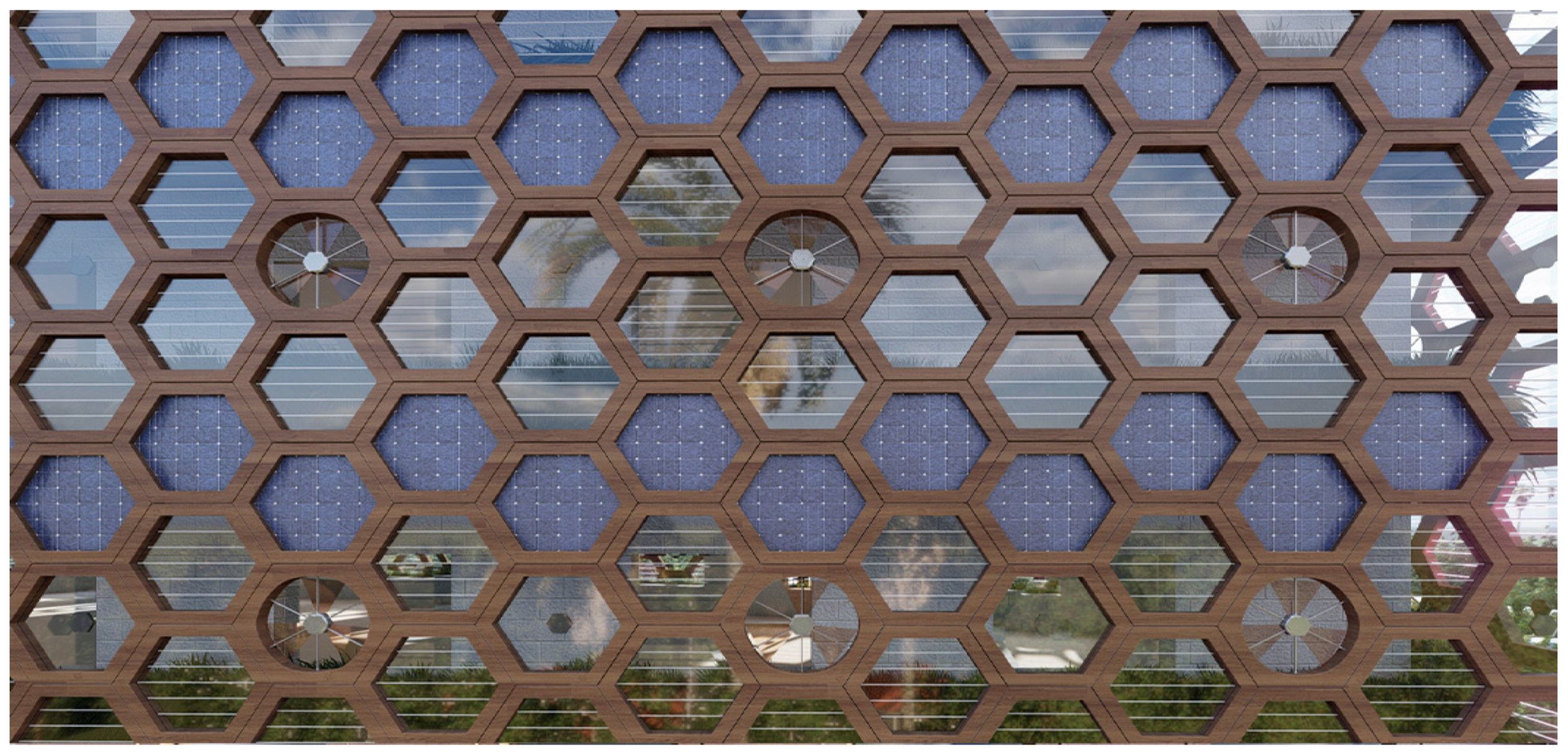
Sustainability 15 05284 g003
Figure 4. View for Nablus city, (Photo: Ghazal 2020).
Sustainability 15 05284 g004
Figure 5. Climate summary of Nablus during the year [52] (from and with the courtesy of Weatherspark).
Sustainability 15 05284 g005
Figure 6. Site location map [53] (from and with the courtesy of the Geomolg team\Edited by: Ghazal 2020).
Sustainability 15 05284 g006
Figure 7. Boundary of Imtedad Al-Seka street map [53] (from and with the courtesy of the Geomolg team\Edited by: Ghazal 2020).
Sustainability 15 05284 g007
Figure 8. Different views of the building’s neighbourhood (Photos: Ghazal 2020).
Sustainability 15 05284 g008
Figure 9. General algorithm of the AGRI|gen\Analysis tool (Diagram: Ghazal 2020).
Sustainability 15 05284 g009
Figure 10. Aerial photo for the neighbourhood, at left cad drawing for buildings boundaries Aerial photo [53] (from and with the courtesy of Geomolg team\Edited by: Ghazal 2020).
Sustainability 15 05284 g010
Figure 11. Buildings modelling output; 3d model for the entire neighbourhood (Screenshot from the Grasshopper code: Ghazal 2020).
Sustainability 15 05284 g011
Figure 12. The Used data tree structure to deliver different information across the grasshopper workflow (Diagram: Ghazal 2020).
Sustainability 15 05284 g012
Figure 13. The three possible scenarios for farming in the neighbourhood (Drawings: Ghazal 2020).
Sustainability 15 05284 g013
Figure 14. Neighbourhood Production analysis algorithm (Diagram: Ghazal 2020).
Sustainability 15 05284 g014
Figure 15. Solar radiation calculation results on the 3D model (Screenshot from the Grasshopper code: Ghazal 2020).
Sustainability 15 05284 g015
Figure 16. DLI calculation algorithm (Diagram: Ghazal 2020).
Sustainability 15 05284 g016
Figure 17. DLI values according to the AGRITECTURE DLI calculator website, compared to the researcher tool [59] (Table and Chart: Ghazal 2020).
Sustainability 15 05284 g017
Figure 18. Comparison between DLI values for the surface facade (Chart: Ghazal 2020).
Sustainability 15 05284 g018
Figure 19. Local neighbourhood consumption fulfilment (Chart: Ghazal 2020).
Sustainability 15 05284 g019
Figure 20. Crops distribution on the facades (Chart: Ghazal 2020).
Sustainability 15 05284 g020
Figure 21. Previous related work by the researcher (Ghazal: 2020).
Sustainability 15 05284 g021
Figure 22. Basic AGRI|gen\Design tool targets (Diagram: Ghazal 2020).
Sustainability 15 05284 g022
Figure 23. Unites types and dimensions (Diagram: Ghazal 2020).
Sustainability 15 05284 g023
Figure 24. AGRI|gen\Design tool general algorithm (Diagram: Ghazal 2020).
Sustainability 15 05284 g024
Figure 25. Shell modelling algorithm and results (Photos and Diagram: Ghazal 2020).
Sustainability 15 05284 g025
Figure 26. Facade tessellation Shell algorithm and results (Photos and Diagram: Ghazal 2020).
Sustainability 15 05284 g026
Figure 27. Used hexagonal tessellation equations (Photo: Ghazal 2020).
Sustainability 15 05284 g027
Figure 28. Units Distribution basic algorithm (Diagram: Ghazal 2020).
Sustainability 15 05284 g028
Figure 29. Rows selection algorithm (Photos and Diagram: Ghazal 2020).
Sustainability 15 05284 g029
Figure 30. Implementing distribution rules algorithm (Photos and Diagram: Ghazal 2020).
Sustainability 15 05284 g030
Figure 31. The used data tree structure to deliver different information across the Grasshopper workflow (Diagram: Ghazal 2020).
Sustainability 15 05284 g031
Figure 32. Units orientation algorithm (Photos and Diagrams: Ghazal 2020).
Sustainability 15 05284 g032
Figure 33. Units orientation results in the entire neighbourhood (Photo: Ghazal 2020).
Sustainability 15 05284 g033
Figure 34. Roof Design algorithm and results (Photos and Diagram: Ghazal 2020).
Sustainability 15 05284 g034
Figure 35. Used units percentage (Chart: Ghazal 2020).
Sustainability 15 05284 g035
Figure 36. Different distribution patterns on facades with different DLI values (Diagram: Ghazal 2020).
Sustainability 15 05284 g036
Figure 37. Exterior perspective for single building from the neighbourhood (Render: Ghazal 2020).
Sustainability 15 05284 g037
Figure 38. High DLI facade pattern (Render: Ghazal 2020).
Sustainability 15 05284 g038
Figure 39. Medium DLI facade pattern (Render: Ghazal 2020).
Sustainability 15 05284 g039
Figure 40. Low DLI facade pattern (Render: Ghazal 2020).
Sustainability 15 05284 g040
Figure 41. Roof Exterior perspective for a single building from the neighbourhood (Render: Ghazal 2020).
Sustainability 15 05284 g041
Figure 42. An interior perspective showing how the system might look from a normal room (Render: Ghazal 2020).
Sustainability 15 05284 g042
Figure 43. General image showing the system installation over the entire neighbourhood (Render: Ghazal 2020).
Sustainability 15 05284 g043
Table 1. Suitable herbs for hydroponic, (Based on dengarden 2020, source [41]).
Common NameLatin Name
TarragonArtemisia dracunculus L.
PeppermintMentha x piperita L.
Green MintMentha L. [such as:
Mentha x piperita L.
Mentha spicata L.
Mentha pulegium L.]
OreganoOriganum vulgare L.
BasilOcimum basilicum L.
SageSalvia officinalis L.
SteviaStevia rebaudiana (Bertoni) Hemsl.
Lemon BalmMelissa officinalis L.
RosemaryRosmarinus officinalis L.
Table 2. Suitable vegetables for hydroponic, (Based on dengarden 2020, source [41]).
Common NameLatin Name
LettuceLactuca sativa L.
SpinachSpinacia oleracea L.
Bok ChoyBrassica chinensis L.
TomatoesSolanum lycopersicum L.
PeppersCapsicum annuum L.
CucumberCucumis sativus L.
CeleryApium graveolens L.
Table 3. Selected crops Requirements, productivity, and consumption (Table: Ghazal 2020).
CropRequired DLIRequired TemperatureConsumption
kg\Family per Month
Productivity
kg\m2 per Year
Sweet peppers25–5017–24°1.55627.7
Tomatoes20–5017–19°16.12833
Cucumber20–3517–27°8.10735
Herbs15–2015–24°0.2430.6
Lettuce12–1815–25°0.28941
Microgreens10–2018–24°1.002105.2
Table 4. Sample data about corps consumption in Palestine, at left, is a summary of the selected crops consumption (Adapted with permission from Ref. [58]. 2020, Palestinian Central Bureau of Statistics).
CropConsumption (kg\Family per Month)
Tomato16.128
Cucumber8.107
Sweet peppers1.556
Herbs0.243
Lettuce0.289
Microgreens (Spinach)1.002
Table 5. Crops consumption details (Table: Ghazal 2020).
CropsFamily Consumption kg\MonthNeighbourhood Consumption kg\MonthTon\Year
Tomatoes16.128558066.96
Cucumber8.107280533.66
Green peppers1.5565386.456
Lettuce0.2891001.2
Spinach1.0023474.164
Thyme0.24384.0781.008936
Table 6. Total available Planting areas per crop on facades and elevations (Table: Ghazal 2020).
Total Planting Areas
ElevationsRoof
PlantFacade AreaWalls AreaWindows AreaPlantArea
Sweet Peppers000Sweet Peppers7339.9
Tomato7130.71452.5510Tomato0
cucumber2279.6430156cucumber0
Herbs593.39042Herbs0
lettuce3036.1537.5180lettuce0
Microgreens1421.7275162Microgreens0
Poor DLI14,107.626851188Poor DLI0
Total area28,56954702238Total area7339.9
Table 7. Total expected yield per crop on facades and elevations (Table: Ghazal 2020).
Total Crops Yields
CropYield kg\m2Total Yield Façade Option (Tons)Total Yield Walls Option (Tons)Total Yield Windows Option (Tons)
FacadeRoof
Sweet Peppers-27.7203.3203.3203.3
Tomato33-235.347.916.8
Cucumber35-79.815.15.5
Herbs0.6-0.40.10.03
Lettuce41-124.522.07.4
Microgreens105.2-149.628.917.0
Table 8. Local neighbourhood consumption fulfilment Percentage for each option (Table: Ghazal 2020).
Local Consumption Fulfilment %
CropNeighbourhood ConsumptionFulfilment % Facade OptionFulfilment % Walls OptionFulfilment % Windows Option
Sweet Peppers6.4563149.243149.243149.24
Tomato66.96351.4271.5825.13
cucumber33.66237.0444.7116.22
herbs1.0135.285.352.50
lettuce1.210,373.341836.46615.00
Microgreens4.1643591.81694.76409.28
Table 9. Units count and costs summary (Diagram: Ghazal 2020).
UnitLEDPVSensorFanTotal
Count29,89641243557324740,824
percentage73.23%10.10%8.71%7.95%100%
expected cost\unit38.557.543.547.5-
Total cost $1,150,996237,130154,729.5154,232.51,697,088
Disclaimer/Publisher’s Note: The statements, opinions and data contained in all publications are solely those of the individual author(s) and contributor(s) and not of MDPI and/or the editor(s). MDPI and/or the editor(s) disclaim responsibility for any injury to people or property resulting from any ideas, methods, instructions or products referred to in the content.