Review

Crop Monitoring in Smallholder Farms Using Unmanned Aerial Vehicles to Facilitate Precision Agriculture Practices: A Scoping Review and Bibliometric Analysis

1
Centre for Water Resources Research, School of Agricultural, Earth and Environmental Science, University of KwaZulu-Natal, Private Bag X01, Scottsville, Pietermaritzburg 3209, South Africa
2
Discipline of Agrometeorology, School of Agricultural, Earth and Environmental Sciences, University of KwaZulu-Natal, Private Bag X01, Scottsville, Pietermaritzburg 3209, South Africa
3
Department of Geography, Environmental Studies and Tourism, University of the Western Cape, Private Bag X17, Bellville 7535, South Africa
4
Centre for Transformative Agricultural and Food Systems, School of Agricultural, Earth & Environmental Sciences, University of KwaZulu-Natal, P/Bag X01, Pietermaritzburg 3209, South Africa
5
International Water Management Institute, Southern Africa Office, Pretoria 0184, South Africa
*
Author to whom correspondence should be addressed.
Sustainability 2023, 15(4), 3557; https://doi.org/10.3390/su15043557
Submission received: 16 January 2023 / Revised: 9 February 2023 / Accepted: 12 February 2023 / Published: 15 February 2023

Abstract

:
In this study, we conducted a scoping review and bibliometric analysis to evaluate the state-of-the-art regarding actual applications of unmanned aerial vehicle (UAV) technologies to guide precision agriculture (PA) practices within smallholder farms. UAVs have emerged as one of the most promising tools to monitor crops and guide PA practices to improve agricultural productivity and promote the sustainable and optimal use of critical resources. However, there is a need to understand how and for what purposes these technologies are being applied within smallholder farms. Using Biblioshiny and VOSviewer, 23 peer-reviewed articles from Scopus and Web of Science were analyzed to acquire a greater perspective on this emerging topical research focus area. The results of these investigations revealed that UAVs have largely been used for monitoring crop growth and development, guiding fertilizer management, and crop mapping but also have the potential to facilitate other PA practices. Several factors may moderate the potential of these technologies. However, due to continuous technological advancements and reductions in ownership and operational costs, there remains much cause for optimism regarding future applications of UAVs and associated technologies to inform policy, planning, and operational decision-making.

1. Introduction

Food insecurity has been gradually increasing and remains a major concern to the global population [1,2,3,4,5,6]. While agricultural production has substantially increased over the past few decades, the demand for food to sustain the expanding population continues to increase [7]. The limited availability of arable land and water resources, the impacts of climate change, and the need to promote environmentally sustainable agricultural practices [8,9,10] are likely to accentuate the pressures exerted upon existing agricultural food production systems [11,12,13].
Subsequently, eradicating hunger and malnutrition by 2030 appears to be an elusive goal that has been further compounded by the impacts of the COVID-19 pandemic [3]. Considering that many of the aforementioned challenges are likely to play a more prominent role in the future, the longevity and productivity of these agricultural food production systems are under significant threat [4]. With many of these systems unable to keep pace with existing food demands, there is a need to improve their sustainability and productivity [14]. This is particularly relevant for smallholder farms, which, despite their relatively small size (less than two hectares), are major contributors to agricultural food production, food security, and socio-economic development [15]. However, many of these smallholder farmers lack critical resources and financial support. Subsequently, their actual productivity severely lags their potential, ultimately limiting their ability to improve food security [7,15]. To remedy this situation, these smallholder farmers require cost-effective and context-specific information to guide their operations to maximize their productivity while optimally utilizing their available resources [7,16].
Over the past decade, the precision agriculture (PA) paradigm has been gaining traction within the agricultural sector and is potentially well suited to deliver on the aforementioned targets. PA practices involve the application of several bespoke management interventions and strategies that are guided and informed by state-of-the-art in data collection, analysis, and communication technologies to enhance crop productivity, reduce unnecessary losses of critical resources such as water and nutrients as well as mitigate potential harmful impacts on the environment [17,18]. According to Boursianis et al. [18], in recent times, the agricultural sector has appeared to be embracing the fourth industrial revolution, with remote sensing technologies featuring quite prominently in PA applications. Although remote sensing has been used for various agricultural applications since the late 1970s, recent advancements in satellite earth observation technologies, unmanned aerial vehicles (UAVs), and geospatial cloud computing have created new and exciting possibilities to more effectively utilize these technologies as decision-support tools to optimize agricultural operations by supporting crop management interventions such as monitoring, mapping, irrigation, and plant diagnosis to name a few [6,18,19]. However, the use of these technologies specifically for crop monitoring to guide PA applications such as fertilizer application and management, crop water use, crop vigor, and yield assessment have featured most prominently across smallholder multi-cropping farming systems [20,21,22,23,24].
Despite their potential for PA applications, the characteristics of remote sensing sensors, i.e., their spatial, spectral, and temporal resolution, largely dictate how these technologies can be effectively utilized. Generally, a trade-off exists between the spatio-temporal resolution of freely available and publicly accessible satellite earth observation datasets. For example, Landsat (at 30 m) and Moderate Resolution Imaging Spectroradiometer (at 250 m) imagery are characterized by spatial resolutions that are generally too coarse for small fields with mixed crops. Furthermore, the temporal resolution of satellite sensors which can be further compounded by cloud cover may limit their feasibility for routine monitoring of crops throughout the growing season [20,25,26,27,28]. While more advanced satellite-earth observation systems and manned-aerial vehicles can overcome these spatio-temporal limitations, the costs associated with data acquisition through these platforms often limit their use for widespread PA applications [29].
The unique characteristics of UAVs, also known as drones, such as their ability to provide a cost-efficient means of accessing high-quality spatially explicit data at user-defined intervals, have seen them emerge as one of the most promising tools to facilitate PA practices [3,29,30]. Despite their immense potential, these technologies possess limitations, which may limit their feasibility for PA applications [3,6,30]. With the application of UAVs in agriculture becoming more prevalent and their potential to facilitate PA practices in smallholder farms being increasingly recognized, it is important to develop a deeper understanding regarding the state of play on the use of UAVs for crop monitoring to facilitate PA practices in the context of smallholder farms.
While the evaluation of UAVs for PA has been well-documented [3], there are limited reviews focusing specifically on smallholder farm applications. Nhamo et al. [7] examined the potential PA applications of UAVs in smallholder farms to improve water use efficiency and enhance agricultural productivity. Sibanda et al. [30] evaluated the potential of using UAVs to assess water quality and quantity. They highlighted existing challenges and prospective opportunities to utilize these technologies to improve crop water productivity in smallholder farms. Although these reviews were comprehensive and yielded new and invaluable insights, they largely focus on the potential of UAVs, specifically in mapping irrigation water quality and quantity and evaluating their potential in mapping irrigated farms. Subsequently, our knowledge and understanding of how these technologies are being utilized to monitor crops in smallholder farms to facilitate PA applications are limited. To address this knowledge gap, in this study, we provide an up-to-date and concise bibliometric and systematic evaluation of literature pertaining to the actual applications of UAVs for crop monitoring in smallholder farms to facilitate PA. It is envisaged that this study will complement the aforementioned reviews and expand upon the existing body of knowledge on this emerging topical research focus area. Furthermore, this review can serve as a potentially useful resource to acquire greater insight into using UAVs to facilitate PA practices in smallholder farms before utilizing these technologies within these settings.
To this end, a scoping review was performed in this study to explore and evaluate the use of UAVs to monitor crops in smallholder farms to facilitate PA, whereby the term crops is inclusive of grains, fruits, or vegetables within the context of this study. The techniques involved in bibliometric and scientometric research, such as mapping, clustering, co-citation, and co-occurrence analyses, are commonly utilized to gain a greater perspective on a particular research topic [6,31]. The use of tools such as Biblioshiny and VOSviewer has become a common practice among researchers to facilitate this process [32,33,34] as they allow for trends to be more easily identified and visualized by (i) highlighting the research that has shaped our understanding of a particular research focus area, (ii) identifying key themes within the literature, (iii) illuminating the links between these themes, and (iv) exploring their evolution over time [6,30,35,36].
This scoping review aims to address the following specific objectives:
  • Identify influential journals, publications, and prominent authors within this research focus area;
  • Identify thematic areas for which UAV-based crop monitoring has been applied to facilitate PA and the methods used across these areas;
  • Discuss the challenges experienced and potential opportunities for future research to benefit smallholder farmers.
This review is organized as follows: Following the introduction, the methods used to select and evaluate the literature is presented in Section 2, whereas the key findings of the bibliometric analysis are described in Section 3. In Section 4, we present an overview of the general trends, challenges, and future opportunities relating to using UAVs to monitor crops in smallholder farms to facilitate PA. Finally, the conclusions and limitations of the study are presented in Section 5.

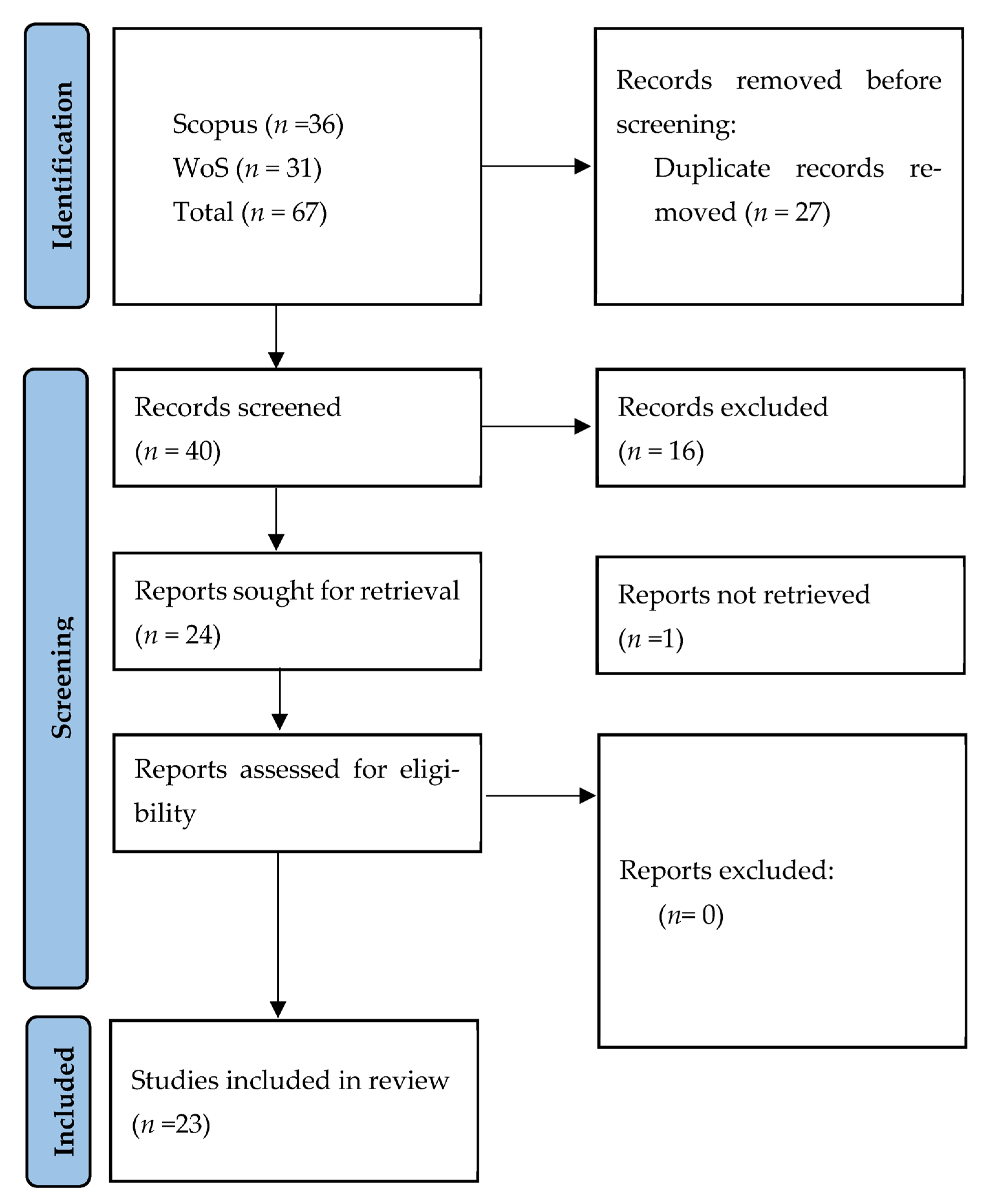
2. Materials and Methods

The bibliometric database was compiled by searching the Scopus and Web of Science (WoS) abstract and citation databases for keywords and variants on 6 December 2022, using the following query string: “(“smallholder farm*” OR “smallholder farming” OR “smallholder agriculture” OR “small scale farm*” OR “small scale agriculture”) AND (“UAV” OR “Drone”).” The selection and structure of keywords used during the search was an iterative process guided by the authors’ experiences in this particular research focus area and previous literature identified through preliminary searches in Google Scholar.
The search was conducted without applying any constraints on the timespan; however, articles that were not published in accredited peer-reviewed journals and not written in English were excluded. The search results returned 36 and 31 references for Scopus and WoS, respectively. The retrieved references (n = 67) were then saved and imported into the R environment (using the bibliometrix-R package). They were combined into a single database before being screened for eligibility. The Preferred Reporting Items for Systematic Reviews and Meta-Analyses extension for scoping reviews (PRISMA-ScR) framework [37] was used to avoid biased reporting by guiding decisions regarding the selection of articles to be included or excluded from the review (Figure 1). The eligibility criteria for the review were defined as follows: (i) the focus of the study was exclusively on the actual application of UAV technologies to monitor crops in smallholder farm settings to facilitate PA, and (ii) the full-length article was available and accessible.
Duplicate records identified within the initial search were removed, and two researchers examined the remaining articles to ensure they met the eligibility criteria. After screening these articles’ titles and abstracts, 24 full-length articles were identified as eligible and were sought for downloading. However, one of these articles was inaccessible. No additional articles were sought following this process. Once the final database (n = 23) had been compiled, key bibliometric data were extracted, analyzed, and mapped using the Biblioshiny App and VOSviewer software [38,39] to address the study’s objectives.

3. Results

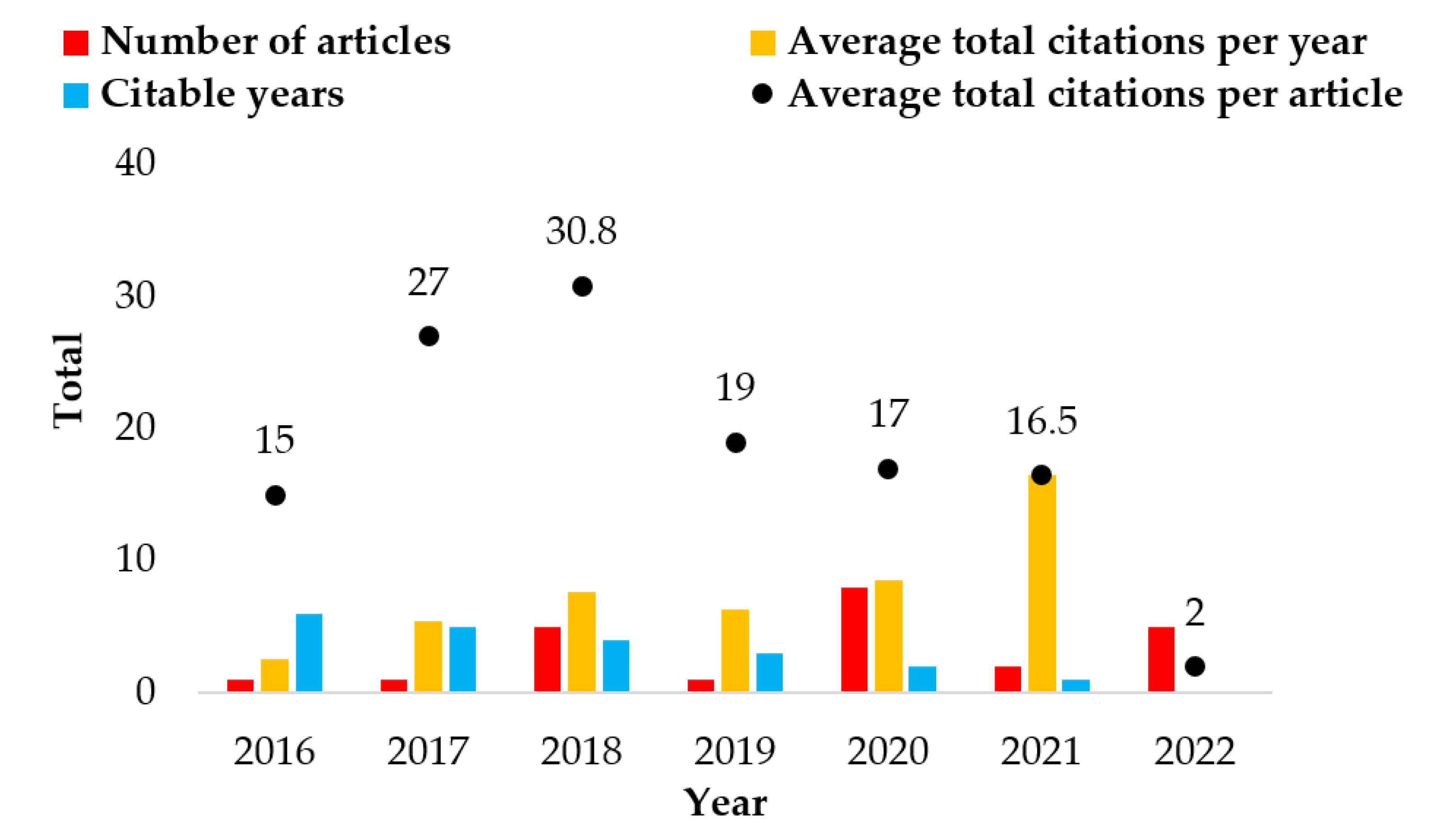
3.1. Historical Evolution

A summary of the key statistics regarding the final literature dataset is provided in Table 1. Research on using UAVs to monitor crops in smallholder farms to facilitate PA first emerged in 2016 and has been gradually increasing with a compound annual growth rate of ~31.00%. The highest productivity was achieved in 2020, with eight articles published this year, representing ~36.00% of the total publications (Figure 2). The period 2017–2018 had the highest average total citations (TCs) per publication, peaking at 30.80. In comparison, the highest average TCs per year occurred in 2021 at 16.5.

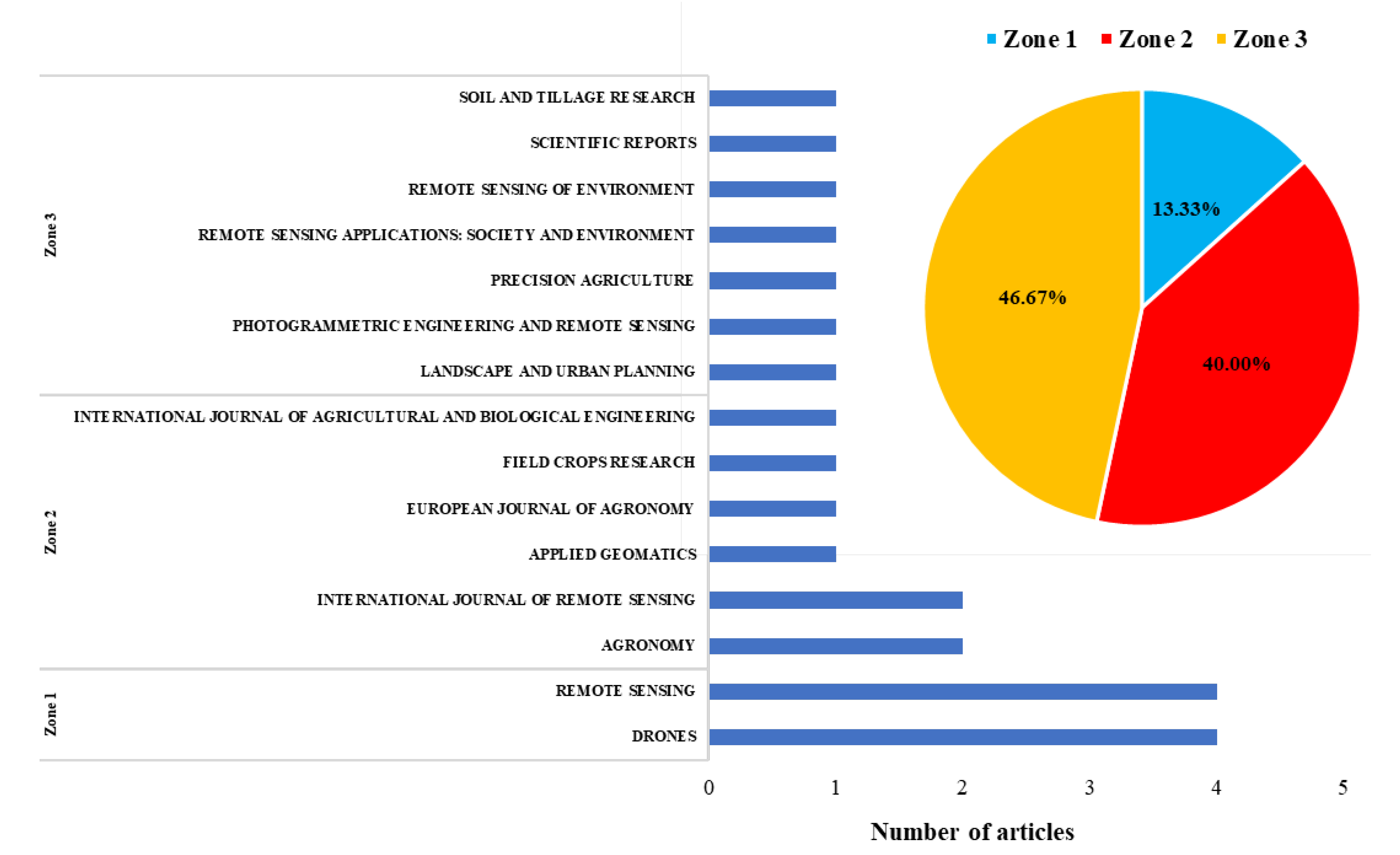
3.2. Most Influential Journals

The final literature database consisted of 15 journals with 23 publications on using UAVs to monitor crops in smallholder farms to facilitate PA. The journals Drones and Remote Sensing have the highest number of articles accounting for ~35% of the total publications. Drones also retain their position at the top of the rankings for TCs with 109. Therefore, this is the dominant journal in this particular research focus area. Figure 3 provides a graphical illustration of the core journals classed according to Bradford’s law which is used to establish the relationship between published articles and the journals they have been published in.
According to Bradford’s law, there are broadly three zones that can be used to categorize the frequency of citations emanating from journals for a particular research focus area. Zone 1 represents the most influential journals as they are cited most frequently in that subject area and likely attract the greatest interest from researchers. Zones 2 and 3 represent the journals with the average and least citations, respectively [40]. Based on Bradford’s law, eight articles were published in two journals categorized as Zone 1, eight were published in six journals categorized as Zone 2, and seven were published in seven journals categorized as Zone 3. As shown in Table 2, Drones and Remote Sensing also appear at the top of the most influential journals when ranked according to their productivity, TCs, and citation impact (H-index).

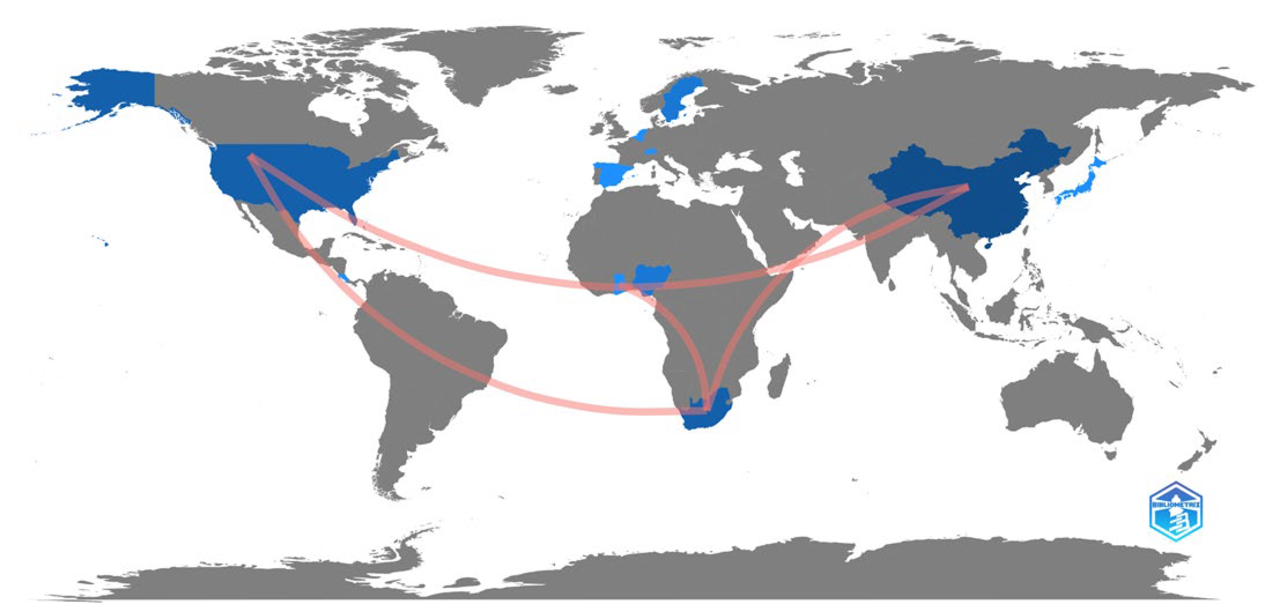
3.3. Analysis of Publications by Country

Regarding the geographic distribution of published research on the use of UAVs to monitor crops in smallholder farms to facilitate PA, 14 countries have been involved in this particular research field. China, South Africa, Nigeria, Switzerland, and the USA are the only countries to have produced more than one publication on the use of UAVs to facilitate PA in smallholder farms and account for ~61.00% of the total number of publications. While these countries rank within the top five for the number of publications produced, when considering TCs and the average citations per publication, only China features consistently within the top five. Collaborations between authors have been mostly restricted to the countries in which they reside; however, there are a few examples of international collaboration (Figure 4). In total, four unique collaboration links are identified, with the strength of these links remaining the same for each collaboration, i.e., only a single published co-authored publication has emanated from each of these links.

3.4. Most Influential Authors and Citation Analysis

A total of 131 authors contributed to the 23 publications on using UAVs to facilitate PA in smallholder farms; however, none were single-authored. One hundred and fifteen authors published only a single article, whereas 16 published two or more. The key author-level performance metrics of the 16 authors with more than one publication are shown in Figure 5. Vimbayi Chimonyo, Alistair Clulow, Tafadzwanashe Mabhaudhi, and Mbulisi Sibanda have been the most active authors in this particular research focus area. Ola Hall and Magnus Jirström have received the highest number of citations. The publications were analyzed according to their global citation score (GCS), average TCs per year, and normalized citation score (Table 3). The GCS is representative of the TCs, a publication received in the abstract and citation databases (Scopus and Web of Science) that were used, and includes citations received from publications in other disciplines [41].
The publication by Wahab et al. [26], which evaluated the use of a UAV-derived vegetation index to assess the vigor and yield of maize during various growth stages, received the highest number of TCs and is among four publications to have received more than ten citations per year. Their investigations demonstrated that using a UAV-derived vegetation index could adequately quantify maize growth and vigor, despite the complex heterogeneous nature of the smallholder farming systems from which it was derived.
The highest-ranking publication with regard to average TCs per year is by Argento et al. [23], which is also among the top five for most TCs. Argento et al. [23] explore using UAV-derived data to guide variable rate fertilizer application in small-medium scale farming systems. Their study revealed that the use of UAV-derived data was able to guide management decisions and contributed to improved efficiency of fertilizer application by ~10.00%, which was achieved through redistributing and reducing the amount of fertilizer that was applied.
The most highly cited paper based on the normalized citation performance metric was Brewer et al. [24]. In this study, the authors utilized UAV-acquired multispectral imagery in concert with machine learning to predict the chlorophyll content of smallholder maize during various phenological growth stages. The study’s results demonstrated that the spatio-temporal variability in chlorophyll could be accurately estimated based on the aforementioned approach and could therefore serve as an important tool to support management applications within smallholder farms.
In addition to the aforementioned studies, others worth noting were by Guo et al. [48] and Zhao et al. [47]. While these studies did not feature at the top of any of the citation performance metrics, they were the only studies to feature in the top five across the various citation metrics used. Guo et al. [48] demonstrated how time-series multispectral imagery captured by a UAV and machine learning could be used to develop soil models to predict field-scale soil organic carbon. Zhao et al. [47] developed a unique approach based on conditional random fields (CRF) to map crops within heterogeneous smallholder farms using UAV-acquired RGB and hyperspectral imagery. The study’s results demonstrated that the CRF method could achieve improved classification performance when utilizing high spatial and spectral resolution datasets.

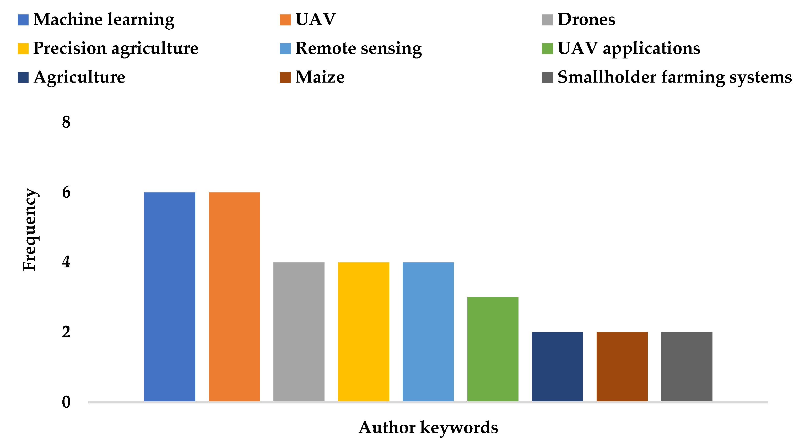
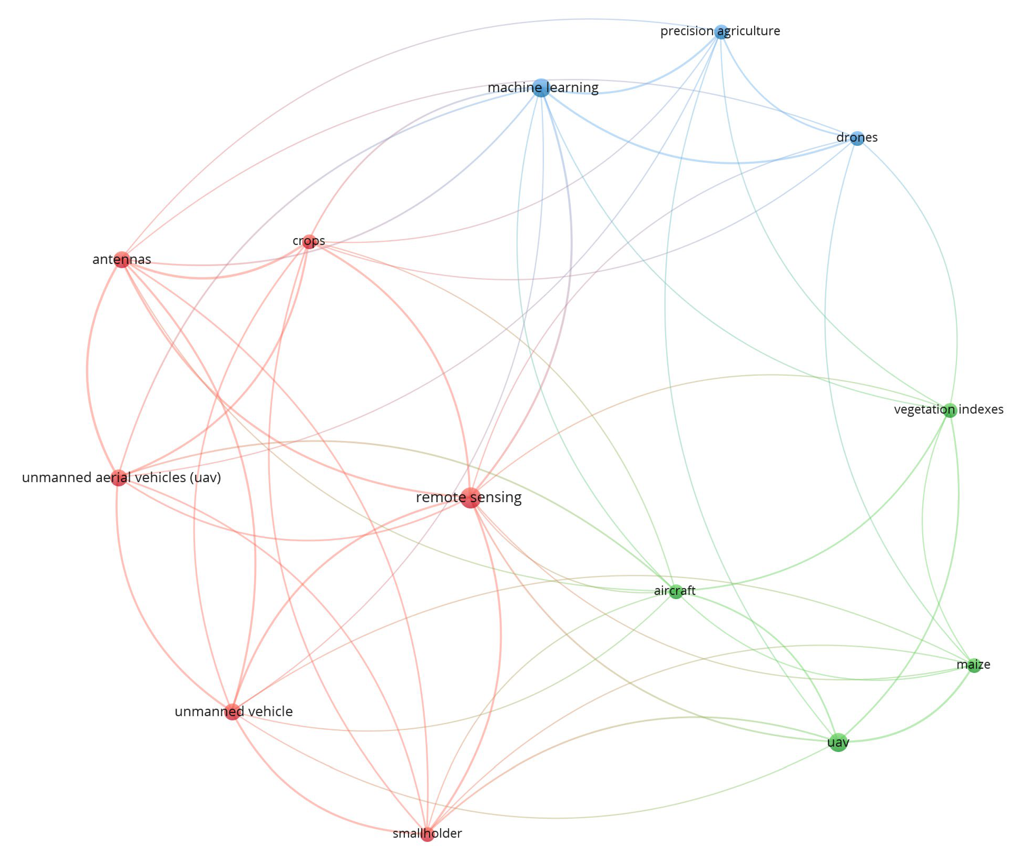
3.5. Analysis of Keywords Frequency, Growth, and Co-Occurrence

Author keywords and the keywords plus metric offered in the Bibiloshiny package were used to evaluate the most relevant words or phrases within the final literature dataset. Keywords plus identifies words or phrases that routinely appear in the titles of the publication’s references but not within the title or author’s keywords [40]. The most frequently used author keywords that have appeared more than once are presented in Figure 6. The presence of “Drones” among the top five author keywords demonstrates that there is variability in the use of terms by authors to describe UAV technologies, but “UAV” is the more popular option.
The words “remote sensing,” “unmanned aerial vehicles (UAV),” and “crops” are among the top five keywords plus (Figure 7). The presence of words such as “food security,” “nitrogen,” “chlorophyll,” and “fertilizers” provide an indication of some of the key focus areas of UAV applications within smallholder farms. The presence of “machine learning” in both the author’s keywords and keywords indicates the preference to utilize these approaches when working with UAV-acquired data. VOSviewer software version 1.6.18 was used to develop a keyword co-occurrence network. The co-occurrence analysis (Figure 8) was performed on 13 keywords with a frequency of ≥4 selected from the 245 keywords within the final literature database. Three clusters of related terms depicted in different colors were identified. The keywords are represented by nodes whereby the size of the nodes represents their frequency of occurrence, with the distance between the nodes representing their relationship strength.
The three clusters may serve as broad indicators of general trends in using UAVs to facilitate PA in smallholder farms. The blue cluster (five keywords) contains “UAV,” “machine learning,” and “precision agriculture” among its keywords which could imply the use of machine learning-based approaches to develop predictive models using UAV-acquired data to guide PA practices. Keywords in the green cluster indicate that UAV-derived vegetation indices (VIs) are often used to monitor spatio-temporal crop growth dynamics, with maize among the most frequently studied crops. This is potentially due to it being a staple crop often grown within many smallholder farming systems. While not providing any detailed insights, the keywords in the red cluster reaffirm the notion of the utility of UAV-based remote sensing techniques for crop monitoring and management in smallholder farms.

4. Discussion

4.1. Overview of Research Themes and Methods

In this study, clustering techniques were employed to aid in identifying broad themes relating to case study applications on the use of UAVs to monitor crops in smallholder farms to facilitate PA. Additionally, the literature was further examined to establish whether other relevant themes were not identified during the clustering analysis. Following the clustering analysis and examination of the literature, three broad themes were identified, these were (i) monitoring of crop development and estimation of yields, (ii) fertilizer management, and (iii) image classification with a focus on crop mapping.
Although these themes can be presented and discussed in isolation, most of the analyzed studies addressed multiple themes, although their focus may have been centered around only one. It should also be noted that while these studies differed concerning how UAV-derived data will be utilized to facilitate PA practices, there are many similarities regarding how the data is captured, processed, and analyzed to develop the outputs used to guide management decisions. Subsequently, the discussion presented herein provides a general overview of how the UAV-derived data was used to address the themes above.
Monitoring crop development throughout the growing season and estimating yields at key growth stages can indicate whether crops are experiencing water stress, have become diseased, or lack nutrients [7,26,58,59]. Hence, it is amongst the most common PA applications facilitated by UAVs within smallholder farms. The health of a crop influences its biophysical properties, which in turn impacts the reflectance spectrum of these crops [7]. The ability of UAVs to explicitly capture these spatial variations in reflectance on-demand and relate it to the crop’s health provides farmers with a powerful tool to facilitate early interventions that can prevent significant crop yield losses. For example, with nitrogen being one of the most yield-limiting nutrients during crop production, using UAV-derived data to detect leaf chlorophyll content, which is closely related to leaf nitrogen, can aid in assessing plant health and vigor [26]. Such information can then guide fertilizer management decisions [23,52]. Water stress is another example of a major limiting factor to crop production. UAV-derived data can be used to estimate water stress indicators, which are then used to guide irrigation decisions [53,54].
UAV-derived VIs are often used to monitor the physiological status of crops due to their simplicity and ability to monitor vegetation cover, growth, and vigor [7,60]. The selection of the spectral bands or VIs used will often depend on their respective strengths or weaknesses for a particular application, user-personal preference, and the spectral resolution of the imaging sensor. From a vegetation mapping and monitoring perspective, multispectral cameras were among the most widely used. This can be attributed to their ability to acquire sufficient data across several portions of the electromagnetic spectrum to extensively monitor vegetation characteristics at a relatively low cost [30]. The normalized difference vegetation index (NDVI) was the most commonly utilized. However, several other popular and useful vegetation indices were used in the reviewed studies to monitor crop development, such as the green normalized difference vegetation index (GNDVI), enhanced vegetation index (EVI), red-edge normalized difference vegetation index (RENDVI), and soil adjusted vegetation index (SAVI). In addition to the VIs derived from data acquired across the visible and near-infrared portions of the electromagnetic spectrum, the acquisition and use of thermal data were also shown to be beneficial in monitoring crop water stress and relating this to vegetation health [54]. Adewopo et al. [22] also note that UAV-derived data can also allow for crop structural parameters such as plant height to be estimated, which may potentially improve the monitoring of crop development or the estimation of yields.
In general, the methods applied in the reviewed studies to monitor crop development, estimate yield, or guide fertilizer management decisions typically involved the combined use of one or more UAV-derived vegetation indices and/or plant structural data that have been captured simultaneously with in-situ measurements of plant physiological variables such as chlorophyll content, yield, aboveground biomass (AGB), plant height or nitrogen content. The most popular approach was the development of regression-based models to capture the relationships between the in situ measurements and UAV-derived data so that it can be used to estimate a particular variable of interest. Various estimation models were developed and applied in the reviewed studies ranging from simplistic parametric linear models [22,23,25,26,42,50,51] to more complex non-parametric machine learning-based models [24,53,55,57]. While each of these models possesses its inherent strengths and weaknesses, the choice of model will generally be influenced by user experience or personal preference, quality and quantity of training and validation data, and computational resources.
For researchers, policymakers, and managers to develop strategies for smallholder farms that are aimed at enhancing their productivity whilst simultaneously ensuring the sustainable and optimal use of critical resources, it is essential for them to possess accurate information on the location and distribution of crops and to then determine how these change in response to management interventions or environmental influences [7]. To this end, land use land cover (LULC) mapping with a focus on crop mapping is often a central part of most PA applications. While various techniques were employed in the reviewed studies to map crops with varying degrees of success, the general approach to crop mapping was fairly similar. Training data which consists of known locations of various LULC classes was usually collected first, either from ground surveys or visual inspection of the high spatial resolution imagery. Once the training data was collected, the data was split into training and validation subsets. Spectral and/or textural data were then collected for each subset. The choice of spectral bands, VIs, or textural features used during the classification process was likely subjective and dependent on factors such as the spectral resolution of the sensor, spectral or textural similarities between the LULC classes, and user experience or personal preference. Thereafter, this data was used as inputs to machine learning [29,44,47] or deep learning [47,49] based approaches to classify the images, with the random forest, support vector machine, and deep neural networks being among the preferred methods of choice.
While the three broad themes identified during the analyses of the final literature dataset represent some of the most common PA applications facilitated by UAVs, two potentially noteworthy exclusions were the use of UAVs for weed management and water use estimation. Poor weed management is one of the most significant contributors to poor crop productivity and quality of products. Due to the various issues associated with conventional weed management approaches, integrated or site-specific weed management facilitated by UAV-derived data has become a popular management strategy. Since integrated weed management promotes efficiency and sustainability, this approach is well-suited for smallholder farm applications. It should be explored further as it can improve the quantity and quality of crop yields whilst reducing economic expenses, labor requirements, and inefficient use of limited resources [61,62].
The accurate estimation of water use or evapotranspiration (ET) can play an important role in PA in smallholder farms and serves various purposes such as assessing crop water stress, guiding irrigation decisions, drought monitoring, and improving the management of available water resources [7,63]. This is particularly important from a smallholder farmer’s perspective as they are among the most vulnerable groups to the impacts of climate change and water scarcity.
While UAV-derived data may be well suited for smallholder farm applications, various UAV-based ET estimation methods can potentially be utilized [7,63], with knowledge regarding their strengths and limitations within smallholder farm settings being fairly limited. Subsequently, there exists an opportunity for future research to further explore how these technologies can be best used to facilitate improved water resources management decisions in smallholder farms.

4.2. Challenges and Opportunities

The discussions thus far have highlighted the immense potential UAVs have to monitor crops in smallholder farms to facilitate PA. However, their actual application in these settings lags behind their potential. Considering the findings of the studies which comprised the final literature dataset, as well as the sentiments described in Rejeb et al. [6], Nhamo et al. [7], and Sibanda et al. [30], there are several factors contributing to this situation. These are summarized as follows:
  • Lack of sufficient in situ data for model development and testing: Many of the methods described in the literature depend on using sufficient good quality in-situ estimates to develop and validate the models used for estimating key variables. However, such data is not always readily available or easily attainable. Furthermore, the data collected may only be representative of specific conditions. This may limit the applicability of the developed models under a range of circumstances, i.e., models may be site- or crop-specific;
  • UAV and sensor specifications: The size and type of UAV, batteries, payload capacity, flight range, and endurance influence the geographical extent that can be covered during a single flight. Subsequently, UAVs may not be well suited for large-scale agricultural applications. Furthermore, due to the limited payload capacity, the sensors typically used are lightweight with relatively low spectral resolutions, which limits their feasibility for particular applications;
  • Weather conditions: while the ability of UAVs to capture data is less severely impacted by cloud cover, adverse weather conditions such as strong winds or rainy conditions can pose significant challenges to data collection;
  • Affordability: Many smallholder farmers are financially constrained; therefore, while UAVs may provide them with invaluable information to improve their productivity, they may not necessarily be able to profit from this due to their inability to respond as and when required. Furthermore, the cost of ownership of UAVs is relatively high and may rise further if higher spectral resolution sensors or data processing software is required. While these costs may be compensated for over time through the acquisition of data on demand and the benefits achieved through improved agricultural operations, the initial financial outlay may put these technologies out of reach for many potential users;
  • Inadequate farming resources and infrastructure: In many regions increasing electricity costs and unreliable electricity supply can prove problematic for UAV operations as batteries and controls require frequent charging;
  • Technical capacity: The operation and maintenance of UAVs and data processing to derive meaningful outputs require skilled expertise that may not be readily available;
  • Civil aviation regulations: Due to the potential risks that may arise from UAV operations, many regions have stringent regulatory frameworks governing civil aviation activities. Subsequently, the operation of UAVs may be restricted to certain applications or require users to acquire a pilot license;
  • Computational resources: The collection, processing, storage, dissemination, and visualization of UAV data can be quite computationally intensive. This may require potential users to purchase additional resources or learn new skills to handle the large volumes of data that accompany the use of UAVs.
Notwithstanding the limitations mentioned above, there is much cause for optimism regarding the increased use of UAVs to monitor crops in smallholder farms to facilitate PA. With the cost of these technologies steadily decreasing over time and the continuous advancements in UAVs, sensors, and data processing platforms, many potential benefits and opportunities exist that warrant further investigation, some of which are described below:
  • While integrated weed management and water use estimation were identified and recommended as two major themes which should be explored further, assessing irrigation water quality and quantity, monitoring and mapping soil attributes, or developing variable rate prescription maps for pesticide management may also be of interest for future research. Furthermore, UAVs have the potential to be applied for other PA applications, such as crop spraying [64,65]. Therefore, the application of these technologies for such practices should also be explored further, as they can potentially reduce manual labor requirements within smallholder farms;
  • Since the UAV-derived data can be used to address multiple themes, the development of decision support tools that can simultaneously address multiple objectives should be explored further;
  • Advances in freely available geospatial cloud computing platforms such as Google Earth Engine (GEE) have created new and exciting opportunities for the processing, analysis, dissemination, and visualization of remote sensing data. Although the platform has largely been utilized for analyzing satellite earth observation data, its functionality can seamlessly extend to UAV-derived data;
  • Satellite earth observation and UAV technologies are typically utilized mutually exclusively, yet these platforms can often provide complementary data for various applications. Subsequently, more research is required to further develop methods to unlock the untapped potential synergies;
  • Several studies have explored and evaluated methods that rely on using in-situ measurements to develop models to estimate variables of interest. However, more emphasis must be placed on developing and evaluating approaches that can guide decision-making without in-situ data. For example, Ellsaßer et al. [66] developed an approach to estimate ET that only requires remotely sensed thermal data as an input to their ET estimation model. Additionally, Chew et al. [49] and Tseng et al. [67] demonstrate how transfer learning can overcome data scarcity challenges when performing image classification;
  • UAVs have been identified as a lower-cost alternative to traditional satellite-based remote sensing techniques to guide and inform PA practices. However, to adequately quantify the benefits that UAVs may provide, the cost of ownership, maintenance, and operations of UAVs and other state-of-the-art technologies should be compared and examined to determine whether they provide acceptable returns on investment [6];
  • Since women play such a prominent and integral role within smallholder agriculture, the adoption of PA practices facilitated by UAV technologies can significantly improve the productivity of their farms. This will contribute immensely to their upliftment and empowerment by enhancing their capacity to deal with challenges they have traditionally faced or are likely to face in the future;
  • The modernized nature of UAV-based PA is likely to aid in changing negative perceptions of being involved or employed within the agricultural sector, which may stimulate interest among the youth and accelerate their involvement within this sector, ultimately contributing to improving its longevity and resilience [68,69].

5. Conclusions

PA agricultural applications facilitated through the use of UAVs has the potential to transform the fortunes of smallholder farmers, as the adoption of these technologies to guide decision-making can enhance agricultural productivity whilst promoting the optimal and sustainable utilization of critical resources.
This, in turn, promotes improved food security and socio-economic well-being and equips these farmers and communities to adapt and build resilience to the impacts of climate change. Considering these potential benefits, in this study, we aimed to examine the state of play regarding the application of UAVs to facilitate PA in smallholder farms. To this end, we employed bibliometric techniques to summarize and analyze the literature relating to this research focus area. This analysis yielded useful insights on general trends, influential publications, journals, and authors, and current challenges and opportunities for the future. However, it should be noted that the findings detailed in our study may be limited in their representation due to the subjective criteria and methods that were used to source and evaluate the literature. Nevertheless, it is envisaged that this review will serve as a useful complement to the existing research and stimulate greater interest in the future in this emerging and topical research area.

Author Contributions

Conceptualization, S.G. and M.M.; methodology, S.G., M.M., M.S. and T.M.; software, S.G. and M.M.; formal analysis, S.G., M.M., A.C., M.S. and T.M.; investigation, S.G. and M.M.; resources, S.G., M.M., R.K., A.C., M.S., V.N., K.C. and T.M.; data curation, S.G. and M.M.; writing—original draft preparation, S.G. and M.M.; writing—review and editing, S.G., M.M., R.K., A.C., M.S., V.N., K.C. and T.M.; visualization, S.G. and M.M..; supervision, R.K., A.C., M.S. and T.M.; project administration, S.G., R.K., A.C., M.S. and T.M.; funding acquisition, S.G. All authors have read and agreed to the published version of the manuscript.

Funding

This research was funded by the Water Research Commission (WRC) through WRC Project C2021-2022-00800 titled: “Leveraging the Google Earth Engine to analyze very-high spatial resolution unmanned aerial vehicle data to guide and inform precision agriculture in smallholder farms.”

Data Availability Statement

No new data were created or analyzed in this study. Data sharing is not applicable to this article.

Acknowledgments

The authors would like to extend their gratitude to the anonymous reviewers for their invaluable input.

Conflicts of Interest

The authors declare no conflict of interest. The funders had no role in the design of the study; in the collection, analyses, or interpretation of data; in the writing of the manuscript; or in the decision to publish the results.

References

  1. Hall, C.; Dawson, T.P.; Macdiarmid, J.I.; Matthews, R.; Smith, P. The impact of population growth and climate change on food security in Africa: Looking ahead to 2050. Int. J. Agric. Sustain. 2017, 15, 124–135. [Google Scholar] [CrossRef] [Green Version]
  2. Paloma, S.G.Y.; Riesgo, L.; Louhichi, K. Impact Analysis of Agri-Food Policies on Food and Nutrition Security in SSA. In The Role of Smallholder Farms in Food and Nutrition Security; Springer Nature: Singapore, 2020. [Google Scholar] [CrossRef]
  3. Panday, U.S.; Pratihast, A.K.; Aryal, J.; Kayastha, R.B. A Review on Drone-Based Data Solutions for Cereal Crops. Drones 2020, 4, 41. [Google Scholar] [CrossRef]
  4. Segarra, J.; Buchaillot, M.L.; Araus, J.L.; Kefauver, S.C. Remote Sensing for Precision Agriculture: Sentinel-2 Improved Features and Applications. Agronomy 2020, 10, 641. [Google Scholar] [CrossRef]
  5. FAO (Food and Agriculture Organization of the United Nations); International Fund for Agricultural Development (IFAD); United Nations Children’s Fund (UNICEF); World Food Programme (WFP); World Health Organization (WHO). The State of Food Security and Nutrition in the World 2021. Transforming Food Systems for Food Security, Improved Nutrition and Affordable Healthy Diets for All; FAO: Rome, Italy, 2021. [Google Scholar] [CrossRef]
  6. Rejeb, A.; Abdollahi, A.; Rejeb, K.; Treiblmaier, H. Drones in agriculture: A review and bibliometric analysis. Comput. Electron. Agric. 2022, 198, 107017. [Google Scholar] [CrossRef]
  7. Nhamo, L.; Magidi, J.; Nyamugama, A.; Clulow, A.D.; Sibanda, M.; Chimonyo, V.G.P.; Mabhaudhi, T. Prospects of Improving Agricultural and Water Productivity through Unmanned Aerial Vehicles. Agriculture 2020, 10, 256. [Google Scholar] [CrossRef]
  8. Elahi, E.; Khalid, Z.; Tauni, M.Z.; Zhang, H.; Lirong, X. Extreme weather events risk to crop-production and the adaptation of innovative management strategies to mitigate the risk: A retrospective survey of rural Punjab, Pakistan. Technovation 2022, 117, 102255. [Google Scholar] [CrossRef]
  9. Elahi, E.; Khalid, Z. Estimating smart energy inputs packages using hybrid optimisation technique to mitigate environmental emissions of commercial fish farms. Appl. Energy 2022, 326, 119602. [Google Scholar] [CrossRef]
  10. Zhang, Z.; Li, Y.; Elahi, E.; Wang, Y. Comprehensive Evaluation of Agricultural Modernization Levels. Sustainability 2022, 14, 5069. [Google Scholar] [CrossRef]
  11. Elahi, E.; Khalid, Z.; Zhang, Z. Understanding farmers’ intention and willingness to install renewable energy technology: A solution to reduce the environmental emissions of agriculture. Appl. Energy 2022, 309, 118459. [Google Scholar] [CrossRef]
  12. Abbas, A.; Waseem, M.; Ahmad, R.; Khan, K.A.; Zhao, C.; Zhou, J. Sensitivity analysis of greenhouse gas emissions at farm level: Case study of grain and cash crops. Environ. Sci. Pollut. Res. 2022, 29, 82559–82573. [Google Scholar] [CrossRef]
  13. Abbas, A.; Zhao, C.; Waseem, M.; Khan, K.A.; Ahmad, R. Analysis of Energy Input–Output of Farms and Assessment of Greenhouse Gas Emissions: A Case Study of Cotton Growers. Front. Environ. Sci. 2022, 9, 725. [Google Scholar] [CrossRef]
  14. Matton, N.; Sepulcre, C.G.; Waldner, F.; Valero, S.; Morin, D.; Inglada, J.; Arias, M.; Bontemps, S.; Koetz, B.; Defourny, P. An Automated Method for Annual Cropland Mapping along the Season for Various Agrosystems Globally Distributed Using Spatial and Temporal High Resolution Time Series. Remote Sens. 2015, 7, 13208–13232. [Google Scholar] [CrossRef] [Green Version]
  15. Kamara, A.; Conteh, A.; Rhodes, E.R.; Cooke, R.A. The Relevance of Smallholder Farming to African Agricultural Growth and Development. Afr. J. Food Agric. Nutr. Dev. 2019, 19, 14043–14065. [Google Scholar] [CrossRef]
  16. Agidew, A.A.; Singh, K.N. The implications of land use and land cover changes for rural household food insecurity in the Northeastern highlands of Ethiopia: The case of the Teleyayen sub-watershed. Agric. Food Secur. 2017, 6, 1–14. [Google Scholar] [CrossRef]
  17. Boursianis, A.D.; Papadopoulou, M.S.; Diamantoulakis, P.; Liopa-Tsakalidi, A.; Barouchas, P.; Salahas, G.; Karagiannidis, G.; Wan, S.; Goudos, S.K. Internet of Things (IoT) and Agricultural Unmanned Aerial Vehicles (UAVs) in Smart Farming: A Comprehensive Review. IEEE Internet Things 2020, 18, 100187. [Google Scholar] [CrossRef]
  18. Sishodia, R.P.; Ray, R.L.; Singh, S.K. Applications of Remote Sensing in Precision Agriculture: A Review. Remote Sens. 2020, 12, 3136. [Google Scholar] [CrossRef]
  19. Bukowiecki, J.; Rose, T.; Kage, H. Sentinel-2 Data for Precision Agriculture?—A UAV-Based Assessment. Sensors 2021, 21, 2861. [Google Scholar] [CrossRef]
  20. Yonah, I.B.; Mourice, S.K.; Tumbo, S.D.; Mbilinyi, B.P.; Dempewolf, J. Unmanned aerial vehicle-based remote sensing in monitoring smallholder, heterogeneous crop fields in Tanzania. Int. J. Remote Sens. 2018, 39, 5453–5471. [Google Scholar] [CrossRef]
  21. El-Hendawy, S.E.; Al-Suhaibani, N.A.; Elsayed, S.; Hassan, W.M.; Dewir, Y.H.; Refay, Y.; Abdella, K.A. Potential of the existing and novel spectral reflectance indices for estimating the leaf water status and grain yield of spring wheat exposed to different irrigation rates. Agric. Water Manag. 2019, 217, 356–373. [Google Scholar] [CrossRef]
  22. Adewopo, J.; Peter, H.; Mohammed, I.; Kamara, A.; Craufurd, P.; Vanlauwe, B. Can a Combination of UAV-Derived Vegetation Indices with Biophysical Variables Improve Yield Variability Assessment in Smallholder Farms? Agronomy 2020, 10, 1934. [Google Scholar] [CrossRef]
  23. Argento, F.; Anken, T.; Abt, F.; Vogelsanger, E.; Walter, A.; Liebisch, F. Site-specific nitrogen management in winter wheat supported by low-altitude remote sensing and soil data. Precis. Agric. 2020, 22, 364–386. [Google Scholar] [CrossRef]
  24. Brewer, K.; Clulow, A.; Sibanda, M.; Gokool, S.; Naiken, V.; Mabhaudhi, T. Predicting the Chlorophyll Content of Maize over Phenotyping as a Proxy for Crop Health in Smallholder Farming Systems. Remote Sens. 2022, 14, 518. [Google Scholar] [CrossRef]
  25. Schut, A.G.T.; Traore, P.C.S.; Blaes, X.; de By, R.A. Assessing yield and fertilizer response in heterogeneous smallholder fields with UAVs and satellites. Field Crop. Res. 2018, 221, 98–107. [Google Scholar] [CrossRef]
  26. Wahab, I.; Hall, O.; Jirström, M. Remote Sensing of Yields: Application of UAV Imagery-Derived NDVI for Estimating Maize Vigor and Yields in Complex Farming Systems in Sub-Saharan Africa. Drones 2018, 2, 28. [Google Scholar] [CrossRef] [Green Version]
  27. Bollas, N.; Kokinou, E.; Polychronos, V. Comparison of Sentinel-2 and UAV Multispectral Data for Use in Precision Agriculture: An Application from Northern Greece. Drones 2021, 5, 35. [Google Scholar] [CrossRef]
  28. Defourny, P.; Bontemps, S.; Bellemans, N.; Cara, C.; Dedieu, G.; Guzzonato, E.; Hagolle, O.; Inglada, J.; Nicola, L.; Rabaute, T.; et al. Near real-time agriculture monitoring at national scale at parcel resolution: Performance assessment of the Sen2-Agri automated system in various cropping systems around the world. Remote Sens. Environ. 2018, 221, 551–568. [Google Scholar] [CrossRef]
  29. Cucho-Padin, G.; Loayza, H.; Palacious, S.; Balcazar, M.; Carbajal, M.; Quiroz, R. Development of low-cost remote sensing tools and methods for supporting smallholder agriculture. Appl. Geomat. 2019, 12, 247–263. [Google Scholar] [CrossRef] [Green Version]
  30. Sibanda, M.; Mutanga, O.; Chimonyo, V.G.P.; Clulow, A.D.; Shoko, C.; Mazvimavi, D.; Dube, T.; Mabhaudhi, T. Application of Drone Technologies in Surface Water Resources Monitoring and Assessment: A Systematic Review of Progress, Challenges, and Opportunities in the Global South. Drones 2021, 5, 84. [Google Scholar] [CrossRef]
  31. Waltman, L.; van Eck, N.J.; Noyons, E.C.M. A Unified Approach to Mapping and Clustering of Bibliometric Networks. 2010. Available online: http://arxiv.org/abs/1006.1032 (accessed on 7 November 2010).
  32. da Costa, T.P.; Gillespie, J.; Cama-Moncunill, X.; Ward, S.; Condell, J.; Ramanathan, R.; Murphy, F. A Systematic Review of Real-Time Monitoring Technologies and Its Potential Application to Reduce Food Loss and Waste: Key Elements of Food Supply Chains and IoT Technologies. Sustainability 2023, 15, 614. [Google Scholar] [CrossRef]
  33. Mühl, D.D.; de Oliveira, L. A bibliometric and thematic approach to agriculture 4.0. Heliyon 2022, 8, e09369. [Google Scholar] [CrossRef]
  34. Bhagat, P.R.; Naz, F.; Magda, R. Artificial intelligence solutions enabling sustainable agriculture: A bibliometric analysis. PLoS ONE 2022, 17, e0268989. [Google Scholar] [CrossRef]
  35. Linnenluecke, M.K.; Marrone, M.; Singh, A.K. Conducting systematic literature reviews and bibliometric analyses. Aust. J. Manag. 2020, 45, 175–194. [Google Scholar] [CrossRef]
  36. Brika, S.K.M.; Algamdi, A.; Chergui, K.; Musa, A.A.; Zouaghi, R. Quality of Higher Education: A Bibliometric Review Study. Front. Educ. 2021, 6, 666087. [Google Scholar] [CrossRef]
  37. Tricco, A.C.; Lillie, E.; Zarin, W.; O’Brien, K.K.; Colquhoun, H.; Levac, D.; Moher, D.; Peters, M.D.; Horsley, T.; Weeks, L.; et al. PRISMA Extension for Scoping Reviews (PRISMA-ScR): Checklist and Explanation. Ann. Intern. Med. 2018, 169, 467–473. [Google Scholar] [CrossRef] [PubMed] [Green Version]
  38. Van Eck, N.J.; Waltman, L. Software survey: VOSviewer, a computer program for bibliometric mapping. Scientometrics 2010, 84, 523–538. [Google Scholar] [CrossRef] [Green Version]
  39. Aria, M.; Cuccurullo, C. bibliometrix: An R-tool for comprehensive science mapping analysis. J. Informetr. 2017, 11, 959–975. [Google Scholar] [CrossRef]
  40. Abafe, E.A.; Bahta, Y.T.; Jordaan, H. Exploring Biblioshiny for Historical Assessment of Global Research on Sustainable Use of Water in Agriculture. Sustainability 2022, 14, 10651. [Google Scholar] [CrossRef]
  41. Ranjbari, M.; Esfandabadi, Z.S.; Shevchenko, T.; Scagnelli, S.D.; Lam, S.S.; Varjani, S.; Aghbashlo, M.; Pan, J.; Tabatabaei, M. An inclusive trend study of techno-economic analysis of biofuel supply chains. Chemosphere 2022, 309, 797–802. [Google Scholar] [CrossRef] [PubMed]
  42. Blaes, X.; Chomé, G.; Lambert, M.-J.; Traoré, P.S.; Schut, A.G.T.; Defourny, P. Quantifying Fertilizer Application Response Variability with VHR Satellite NDVI Time Series in a Rainfed Smallholder Cropping System of Mali. Remote Sens. 2016, 8, 531. [Google Scholar] [CrossRef] [Green Version]
  43. Du, M.; Noguchi, N.; Itoh, A.; Shibuya, Y. Multi-temporal monitoring of wheat growth by using images from satellite and unmanned aerial vehicle. Int. J. Biol. Agric. Eng. 2017, 10, 1–13. [Google Scholar]
  44. Hall, O.; Dahlin, S.; Marstorp, H.; Bustos, M.F.A.; Öborn, I.; Jirström, M. Classification of Maize in Complex Smallholder Farming Systems Using UAV Imagery. Drones 2018, 2, 22. [Google Scholar] [CrossRef] [Green Version]
  45. Wang, J.; Ge, H.; Dai, Q.; Zhou, G.; Qin, M.; Gu, C. Unsupervised discrimination between lodged and non-lodged winter wheat: A case study using a low-cost unmanned aerial vehicle. Int. J. Remote Sens. 2018, 39. [Google Scholar] [CrossRef]
  46. Chen, Z.; Miao, Y.; Lu, J.; Zhou, L.; Li, Y.; Zhang, H.; Lou, W.; Zhang, Z.; Kusnierek, K.; Liu, C. In-Season Diagnosis of Winter Wheat Nitrogen Status in Smallholder Farmer Fields Across a Village Using Unmanned Aerial Vehicle-Based Remote Sensing. Agronomy 2019, 9, 619. [Google Scholar] [CrossRef] [Green Version]
  47. Zhao, J.; Zhong, Y.; Hu, X.; Wei, L.; Zhang, L. A robust spectral-spatial approach to identifying heterogeneous crops using remote sensing imagery with high spectral and spatial resolutions. Remote Sens. Environ. 2020, 239, 111605. [Google Scholar] [CrossRef]
  48. Guo, L.; Fu, P.; Shi, T.; Chen, Y.; Zhang, H.; Meng, R.; Wang, S. Mapping field-scale soil organic carbon with unmanned aircraft system-acquired time series multispectral images. Soil Tillage Res. 2020, 196, 104477. [Google Scholar] [CrossRef]
  49. Chew, R.; Rineer, J.; Beach, R.; O’Neil, M.; Ujeneza, N.; Lapidus, D.; Miano, T.; Hegarty-Craver, M.; Polly, J.; Temple, D.S. Deep Neural Networks and Transfer Learning for Food Crop Identification in UAV Images. Drones 2020, 4, 7. [Google Scholar] [CrossRef] [Green Version]
  50. Breunig, F.M.; Galvão, L.S.; Dalagnol, R.; Santi, A.L.; Della Flora, D.P.; Chen, S. Assessing the effect of spatial resolution on the delineation of management zones for smallholder farming in southern Brazil. Remote Sens. Appl. Soc. Environ. 2020, 19, 100325. [Google Scholar] [CrossRef]
  51. Peter, B.G.; Messina, J.P.; Carroll, J.W.; Zhi, J.; Chimonyo, V.; Lin, S.; Snapp, S.S. Multi-Spatial Resolution Satellite and sUAS Imagery for Precision Agriculture on Smallholder Farms in Malawi. Photogramm. Eng. Remote Sens. 2020, 86, 107–119. [Google Scholar] [CrossRef]
  52. Gracia-Romero, A.; Kefauver, S.C.; Vergara-Díaz, O.; Hamadzirip, E.; Zaman-Allah, M.A.; Thierfelder, C.; Prassana, B.M.; Cairns, J.E.; Araus, J.L. Leaf versus whole-canopy remote sensing methodologies for crop monitoring under conservation agriculture: A case of study with maize in Zimbabwe. Sci. Rep. 2020, 10, 1–17. [Google Scholar] [CrossRef]
  53. Ndlovu, H.S.; Odindi, J.; Sibanda, M.; Mutanga, O.; Clulow, A.; Chimonyo, V.G.P.; Mabhaudhi, T. A Comparative Estimation of Maize Leaf Water Content Using Machine Learning Techniques and Unmanned Aerial Vehicle (UAV)-Based Proximal and Remotely Sensed Data. Remote Sens. 2021, 13, 4091. [Google Scholar] [CrossRef]
  54. Brewer, K.; Clulow, A.; Sibanda, M.; Gokool, S.; Odindi, J.; Mutanga, O.; Naiken, V.; Chimonyo, V.G.P.; Mabhaudhi, T. Estimation of Maize Foliar Temperature and Stomatal Conductance as Indicators of Water Stress Based on Optical and Thermal Imagery Acquired Using an Unmanned Aerial Vehicle (UAV) Platform. Drones 2022, 6, 169. [Google Scholar] [CrossRef]
  55. Jiang, J.; Atkinson, P.M.; Zhang, J.; Lu, R.; Zhou, Y.; Cao, Q.; Tian, Y.; Zhu, Y.; Cao, W.; Liu, X. Combining fixed-wing UAV multispectral imagery and machine learning to diagnose winter wheat nitrogen status at the farm scale. Eur. J. Agron. 2022, 138, 126537. [Google Scholar] [CrossRef]
  56. Kleinschroth, F.; Banda, K.; Zimba, H.; Dondeyne, S.; Nyambe, I.; Spratley, S.; Winton, R.S. Drone imagery to create a common understanding of landscapes. Landsc. Urban Plan. 2022, 228, 104571. [Google Scholar] [CrossRef]
  57. Alabi, T.R.; Adewopo, J.; Duke, O.P.; Kumar, P.L. Banana Mapping in Heterogenous Smallholder Farming Systems Using High-Resolution Remote Sensing Imagery and Machine Learning Models with Implications for Banana Bunchy Top Disease Surveillance. Remote Sens. 2022, 14, 5206. [Google Scholar] [CrossRef]
  58. Xue, J.; Sue, B. Significant Remote Sensing Vegetation Indices: A Review of Developments and Applications. J. Sens. 2017, 2017, 1353691. [Google Scholar] [CrossRef] [Green Version]
  59. Radoglou-Grammatikis, P.; Sarigiannidis, P.; Lagkas, T.; Moscholios, I. A compilation of UAV applications for precision agriculture. Comput. Netw. 2020, 172, 107148. [Google Scholar] [CrossRef]
  60. Yeom, J.; Jung, J.; Chang, A.; Maeda, M.; Landivar, J. Automated Open Cotton Boll Detection for Yield Estimation Using Unmanned Aircraft Vehicle (UAV) Data. Remote Sens. 2018, 10, 1895. [Google Scholar] [CrossRef] [Green Version]
  61. Esposito, M.; Crimaldi, M.; Cirillo, V.; Sarghini, F.; Maggio, A. Drone and sensor technology for sustainable weed management: A review. Chem. Biol. Technol. Agric. 2021, 8, 1–11. [Google Scholar] [CrossRef]
  62. Kawamura, K.; Asai, H.; Yasuda, T.; Soisouvanh, P.; Phongchanmixay, S. Discriminating crops/weeds in an upland rice field from UAV images with the SLIC-RF algorithm. Plant Prod. Sci. 2020, 24, 198–215. [Google Scholar] [CrossRef]
  63. Niu, H.; Zhao, T.; Wang, D.; Chen, Y. Estimating Evapotranspiration of Pomegranate Trees Using Stochastic Configuration Networks (SCN) and UAV Multispectral Imagery. J. Intell. Robot. Syst. 2022, 104, 66. [Google Scholar] [CrossRef]
  64. Sarri, D.; Martelloni, L.; Rimediotti, M.; Lisci, R.; Lombardo, S.; Vieri, M. Testing a multi-rotor unmanned aerial vehicle for spray application in high slope terraced vineyard. J. Agric. Eng. 2019, 50, 38–47. [Google Scholar] [CrossRef] [Green Version]
  65. Chen, H.; Lan, Y.; Fritz, B.K.; Hoffmann, W.C.; Liu, S. Review of agricultural spraying technologies for plant protection using unmanned aerial vehicle (UAV). Int. J. Agric. Biol. Eng. 2021, 14, 38–49. [Google Scholar] [CrossRef]
  66. Ellsäßer, F.; Röll, A.; Stiegler, C.; Hölscher, D. Introducing QWaterModel, a QGIS plugin for predicting evapotranspiration from land surface temperatures. Environ. Model. Softw. 2020, 130, 104739. [Google Scholar] [CrossRef]
  67. Tseng, H.H.; Yang, M.D.; Saminathan, R.; Hsu, Y.C.; Yang, C.Y.; Wu, D.H. Rice Seedling Detection in UAV Images Using Transfer Learning and Machine Learning. Remote Sens. 2022, 14, 2837. [Google Scholar] [CrossRef]
  68. Kwakye, B.D.; Brenya, R.; Cudjoe, D.A.; Sampene, A.K.; Agyeman, F.O. Agriculture Technology as a Tool to Influence Youth Farming in Ghana. Open J. Appl. Sci. 2021, 11, 885–898. [Google Scholar] [CrossRef]
  69. Henning, J.I.F.; Matthews, N.; August, M.; Madende, P. Youths’ Perceptions and Aspiration towards Participating in the Agricultural Sector: A South African Case Study. Soc. Sci. 2022, 11, 215. [Google Scholar] [CrossRef]
Figure 1. PRISMA-ScR flow diagram for article selection.
Sustainability 15 03557 g001
Figure 2. Annual distribution of average yearly citations and publications pertaining to the use of UAVs to facilitate PA in smallholder farms.
Sustainability 15 03557 g002
Figure 3. Classification of journals according to Bradford’s law, contributing to the publication of research pertaining to the use of UAVs to facilitate PA in smallholder farms.
Sustainability 15 03557 g003
Figure 4. Global publications and collaborations, whereby the darker the shade of blue, the larger the number of publications, with the lines indicating international collaboration.
Sustainability 15 03557 g004
Figure 5. Analysis of key author-level citation metrics for authors with more than one publication.
Sustainability 15 03557 g005
Figure 6. Frequency of author’s keywords.
Sustainability 15 03557 g006
Figure 7. Frequency of top 20 keywords plus.
Sustainability 15 03557 g007
Figure 8. Co-occurrence network of the keyword that appeared at least four times within the final literature database.
Sustainability 15 03557 g008
Table 1. A summary of the key bibliographic information about the final literature dataset.
DescriptionResultsDescriptionResults
Timespan2016–2022Keywords Plus (ID)187
Number of journals15Author’s Keywords (DE)81
Number of publications23Authors131
Annual Growth Rate %30.77Authors of single-authored
documents
0
Document Average Age2.26Single-authored documents0
Average citations per
document
17.13Co-Authors per document6.57
References1071International co-authorships %8.70
Table 2. Productivity of the publication sources ranked in the table according to the number of articles published.
JournalNumber of PublicationsTCsh-IndexPublication Year Start
Drones410932018
Remote Sensing42632016
Agronomy22222019
International Journal of Remote Sensing23022018
Applied Geomatics11212020
European Journal of Agronomy1112022
Field Crops Research14612018
International Journal of Agricultural and Biological Engineering12712017
Photogrammetric Engineering and Remote Sensing1712020
Precision Agriculture12912021
Remote Sensing Applications: Society and Environment11312020
Remote Sensing of Environment13412020
Scientific Reports1412020
Soil and Tillage Research13412020
Landscape and Urban Planning1002022
Table 3. Global citation score of publications (in chronological order) relating to the use of UAVs to facilitate PA in smallholder farms.
AuthorJournalTCsTC Per YearNormalized TC
[42]Remote Sensing152.141
[43]International Journal of Biological and Agricultural Engineering274.51
[26]Drones5110.21.66
[25]Field Crops Research469.21.49
[44]Drones275.40.88
[45]International Journal of Remote Sensing173.40.55
[20]International Journal of Remote Sensing132.60.42
[46]Agronomy194.751
[47]Remote Sensing of Environment3411.332
[48]Soil and Tillage Research3411.332
[49]Drones299.671.71
[50]Remote Sensing Applications: Society and Environment134.330.76
[29]Applied Geomatics1240.71
[51]American Society for Photogrammetry and Remote Sensing72.330.41
[52]Scientific Reports41.330.24
[22]Agronomy310.18
[23]Precision Agriculture2914.51.76
[53]Remote Sensing420.24
[24]Remote Sensing773.5
[54]Drones221
[55]European Journal of Agronomy110.5
[56]Landscape and Urban Planning000
[57]Remote Sensing000
Disclaimer/Publisher’s Note: The statements, opinions and data contained in all publications are solely those of the individual author(s) and contributor(s) and not of MDPI and/or the editor(s). MDPI and/or the editor(s) disclaim responsibility for any injury to people or property resulting from any ideas, methods, instructions or products referred to in the content.

