1. Introduction
Access to safe and clean drinking water, sanitation facilities and good hygiene practice and education are paramount to the survival and good health of the population and are considered a human right [
1]. However, billions of people still do not have access to safe water, sanitation, and hygiene (WASH) services; in 2020 alone, “2 billion people lacked safely managed drinking water services, 3.6 billion lacked safely managed sanitation services, and 2.3 billion lacked basic hygiene services” [
2] (p.13). The lack of WASH provision negatively impacts the quality of life beyond physical health and into aspects such as livelihood, the ability to attend school and mental health [
3], as well as placing strain on economies and national health systems [
4]. In terms of physical health, poor WASH services can allow the prevalence of a multitude of serious illnesses that are otherwise preventable or easily managed [
4].
Disasters are defined by the United Nations as “a serious disruption of the functioning of a community or a society involving widespread human, material, economic or environmental losses and impacts, which exceeds the ability of the affected community or society to cope using its own resources” [
5] (p.9). Therefore, disasters are the result of hazards, for example naturally occurring phenomena like earthquakes, extreme weather conditions or a disease, negatively affecting infrastructure, communities or people that have not been adequately protected or prepared for such an event. Access to clean water, sanitation facilities and the upkeep of good hygiene is crucial for ensuring that victims of disasters remain healthy in the aftermath of a disaster [
6]. In places where adequate WASH services are already scarce, disasters can cause serious damage or contamination of these crucial water sources, treatment centers and sanitation facilities [
6]. Emergency measures often result in displaced people sheltering in crowded communal areas which, coupled with the lack of WASH facilities, can lead to the rapid spread of waterborne illnesses. Diarrheal diseases such as cholera, are the leading cause of death in such situations where people are often more susceptible to illness or epidemic outbreaks [
6]. Some disasters, for example droughts or the sudden pollution of a water source in an event such as an oil spill, apply direct and often long-term strain to WASH services, and the recovery process of such disasters will be different to the aftermath of events like an earthquake where infrastructure may need to be rebuilt.
The sudden and widespread consequences of disasters means that relief and recovery efforts involve a variety of stakeholders and sectors. Immediate humanitarian aid, in terms of emergency WASH provisions, often requires presence on the ground, performing actions such as “trucking water, treating piped water, repairing broken water supply and sanitation systems, drilling wells, building temporary latrines, providing essential hygiene items and delivering hygiene messages” [
7]. This requires funding, immensely wider communication, and cooperation and, in certain disaster scenarios, can pose a danger to the aid workers.
In an age when a vast number of jobs and tasks are becoming more automated with the advancement of technology, it therefore raises the question of how technology can be applied to disaster situations to aid with the provision and rehabilitation of WASH services during and immediately after the hazardous event. Earth observation tools, such as satellites, drones and unmanned aerial aircraft (UAVs) are a type of technology that has improved greatly over the past couple of decades and have been increasingly utilized and studied for the benefits they provide to various early warning systems, scientific research, remote sensing, and data gathering. This development and scientific work provide an opportunity to assess the potential use Earth observation tools may have in enabling safe water and sanitation to be safely provided during, and after, a hazardous event.
2. Materials and Methods
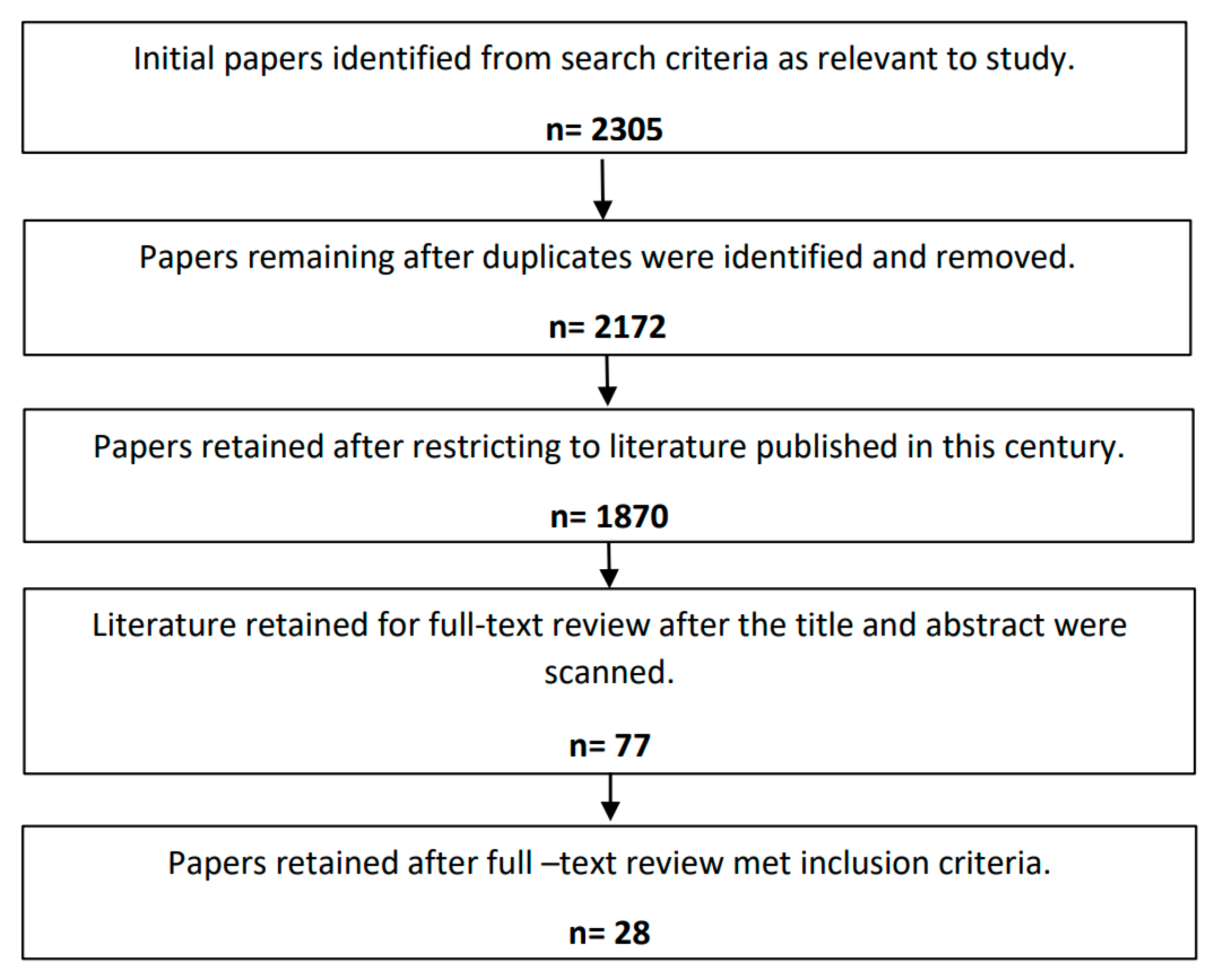
Literature was searched by using Publish or Perish software, see
Figure S1 in Supplementary Materials, which scanned the Web of Science database for literature containing title words relevant to the specified search strings. The Web of Science database was chosen to ensure the resulting literature was specific and targeted, where using other databases such as Google Scholar may have returned results that were too broad. The overall aim of the literature review was to investigate the potential for Earth observation tools to assist with WASH services in the context of hazardous events. It was acknowledged that this specific area of research is yet to be commonly explored, and therefore literature that was solely focused on this topic was unlikely to be frequent. It was therefore decided that a number of the search strings would be broad enough to encompass literature that was related to the use of Earth observation tools in relation to WASH, outside of the context of hazardous events, as well as the use of Earth observation tools in common water related disasters, but with a focus on WASH not obligatory. This would provide the opportunity to understand the extent and scope of the available technology and go on to suggest how it could be applied to WASH services in the context of disasters.
Each search string contained a search term related to various Earth observation tools, including satellites, drones, and UAVs, to ensure that the use of this technology was the focus of all the literature results, whilst a variation of water, sanitation and disaster related terms were used. To include as many relevant papers as possible, the search strings did not always contain a term related to WASH, Earth observation and disasters every time, as it was recognized that this may be too restrictive. Therefore, variations of combinations were chosen, with the only constant being an Earth observation term was always included in each string. As the two most common water related disasters and as the timescale of the project meant excessive numbers of searches would not be feasible, droughts and earthquakes were the only two specific disasters used as search terms; other generic disaster related terms were used.
There are four stages of a disaster [
8]:
Mitigation,
Preparedness,
Response,
Recovery.
It was decided that this systematic review would focus on the opportunity Earth observation tools provide for WASH assistance during the latter two stages of a disaster-the response and recovery phases. This decision is largely due to it being acknowledged that the use of Earth observation tools for the construction, implementation and monitoring of early warning systems and disaster risk reduction strategies is already a well-researched and widely documented topic. However, as the technology and processes used in this area of research may be relevant to the use of Earth observation for the response and recovery phase, the terms ‘early warning system’ and ‘disaster risk reduction’ were included as a search term to ensure no relevant material was missed.
Once potentially relevant scientific literature was identified by Publish or Perish, duplicates were removed, and the literature was scanned against the inclusion and exclusion criteria shown in
Table 1. This was done in stages, where the publication date was first checked against the exclusion criteria, followed by a brief scan of the title and abstract. If this was sufficient to determine exclusion, then the papers were removed. If not, then the full text was scanned against the inclusion criteria, and any papers that did not meet the criteria were removed. The papers where the full text scan met the inclusion criteria were retained for review and analysis to explore how the information regarding Earth observation technology presented can be applied to assist WASH in the response and recovery phase of disasters.
A Google search was also conducted to identify any relevant grey literature. One search string encompassing the overall objective of the literature review was chosen, to restrict the number of results generated. The first two pages of results were scanned for relevance; the link name, website title and contents were briefly read to determine whether the literature had any applicable information to the study. If there was no correlation, then the literature was rejected. Any grey literature that met the inclusion criteria was taken forward for review and analysis.
It is important to acknowledge that, within the literature reviewed, there likely exists a form of unavoidable bias, as most of the work aims to present a certain outcome or view. This bias was taken into consideration when reviewing and analyzing the papers. There was also an inevitable amount of bias in the selection process for the final papers that were retained for analysis and discussion. This is from the scanning of papers to determine if they met the inclusion or exclusion criteria, as there was a significant amount of personal judgement involved in this decision. Whilst this may have been minimized by the fact that one person conducted all reviewing and excluding, and therefore the process was fairly uniform, it must be accepted that this process may have meant that some relevant literature was missed. The scientific papers and grey literature that met the inclusion criteria were analyzed and reviewed, and the next chapter explores how the outcomes of this analysis demonstrate the potential for Earth observation technologies to assist with WASH in response and recovery phases of disasters.
4. Discussion
Three common uses of Earth observation technology were identified in the literature. These were:
This section analyses the methods used in these three areas and suggests how these approaches and outcomes can be applied to WASH in the context of disaster response and recovery.
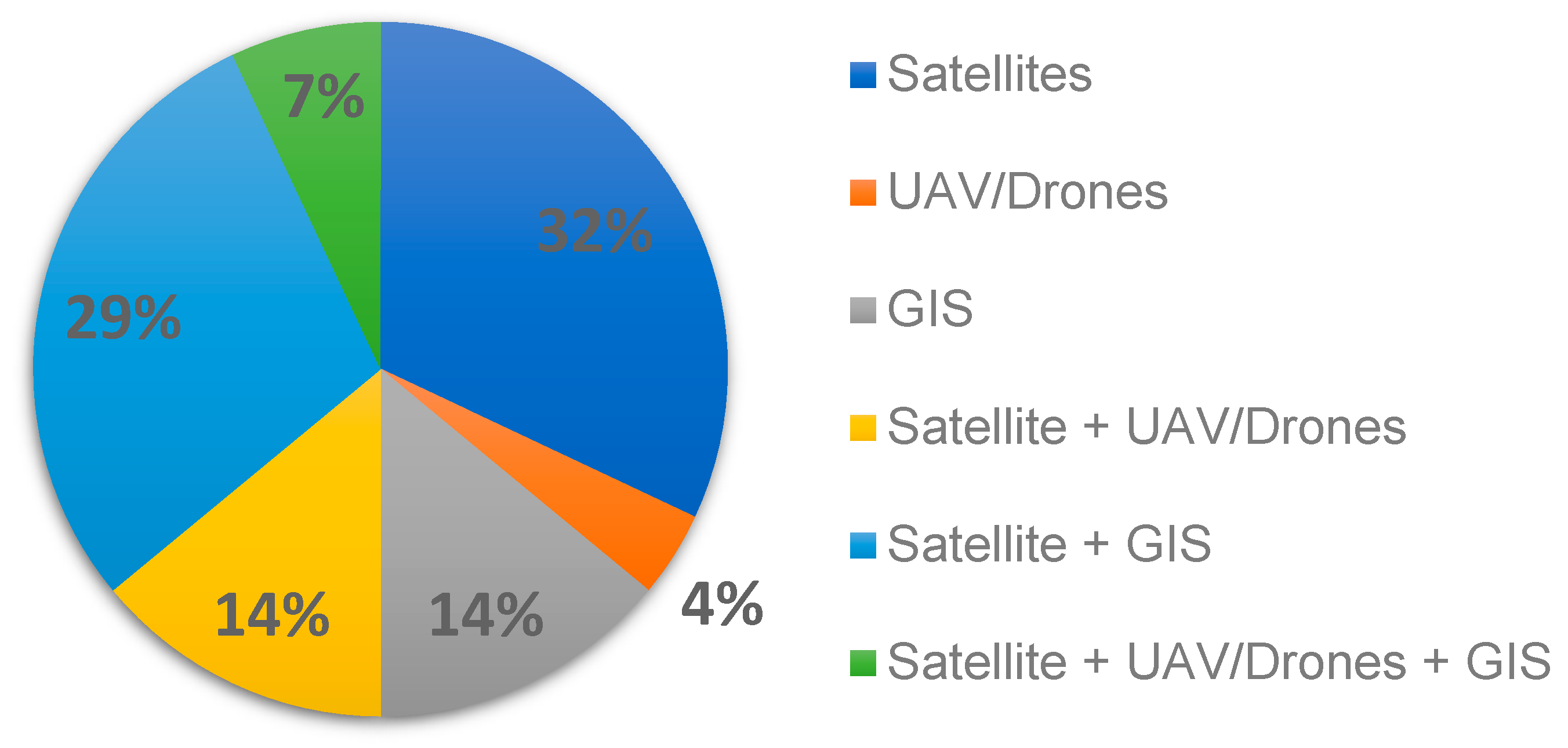
Nine (32%) scientific studies (
Table 2) and two pieces (50%) of grey literature [
37,
40] discussed the potential for Earth observation technology to be utilized for the purpose of monitoring surface water quality. It was established that satellites equipped with remote sensing instruments have the capability of measuring or detecting certain water quality parameters. The LANDSAT satellite, the Moderate Resolution Imaging Spectroradiometer (MODIS) and Multi-angle Imaging Spectroradiometer (MISR) instruments on the NASA satellite Terra, Sentinel 1′s Synthetic Aperture Radar (SAR) and Sentinel 2′s multispectral optical system were evaluated in many of these studies, for their combined ability to measure data such as land surface temperature, enhanced vegetation index, soil humidity [
11,
16,
27,
28,
37]. Surface water is easily detectable by satellites in most weather conditions because of its low reflectance [
34], and substances in the surface water such as suspended sediments, cyanobacterial pigments, algae or oil spills significantly change the spectral or thermal properties of the surface water and are therefore detectable from satellites, mostly when on a large scale [
11,
28,
36]. The resolution of the satellite instruments is the major limiting factor when looking at small scale events or areas, as in some cases a small river may only be represented by one or two pixels and therefore it is more suited to large scale events, or long-term monitoring of wider areas [
36]. Long-term monitoring using LANDSAT is particularly advantageous as there is extensive historical data to be able to extract data for comparison and variation detection as well as the revisit time of different satellites depending on their orbital path, which means that new images could be daily or even may be several days apart [
16,
27,
40]. Images from many satellites are often pre-processed and then accessible for free [
27]. SERVIR is a collaboration between NASA and the United States Agency for International Development that allows low-income or developing countries to be provided with water monitoring information from earth observation technologies to benefit their risk management and land use [
11].
Satellite imaging can be negatively impacted by atmospheric conditions like cloud cover, although it is mentioned that Sentinel 1′s SAR can operate in all weather conditions [
16,
40]. Unlike satellites, UAVs operate at a much closer proximity to the target area and are therefore unaffected by the cloud cover or the majority of weather conditions, and can be equipped with sensors similar to those on satellites to collect the same data [
17,
25,
26,
27]. The closer proximity and controllable flight path results in targeted images of a higher resolution, however the size area captured in a single image is limited [
27,
36]. The UAVs can be expensive, especially when additional sensors and capabilities are included and they are subject to local legislative restrictions which can prohibit them from being flown in certain areas [
25,
27,
36]. Two studies (7%) looked at experimentally equipping drones or UAVs with specialized cameras or sensors to enable them to collect water quality data [
17,
25]. These studies showed that it is possible for UAVs to detect variation due to water deficiency or disease, determine water quality parameters such as pH, temperature, turbidity, dissolved oxygen, and CO2 as well as potentially being fitted with an automatic water sampling system [
17,
25]. The potential of GIS to be integrated into systems to aid with monitoring was also highlighted in another two studies, for example for the detection of sudden water pollution events, and with the development of management plans [
28,
29].
The information surrounding the abilities of Earth observation technologies to be used in the monitoring of surface water quality has potential applications to assist with WASH services in the response and recovery phases of disasters. It is apparent that satellites, with their various revisit times, more expansive area images and ability to detect large scale events would be most suited to providing images of the initial effect of the disaster. This can then be used to identify whether any surface drinking water sources have been impacted as well as providing updates with each new image on the recovery progress for surface waters. In a smaller event, this can be done with a UAV, providing they are legally allowed to fly over the area in question. The UAVs would be helpful in monitoring water quality, as areas may be unsafe or hard to access in the immediate aftermath of a hazardous event and the UAV could obtain water samples or high-resolution images following an exact flight path [
27,
36]. In a disaster situation which devastates infrastructure, for example an earthquake, it is possible that underground sanitation pipework may be damaged and could start to contaminate surface water. This would be detected in the water quality testing and would highlight the damage to the sanitation services which can then be managed and assessed. In an emergency scenario with water infrastructure damaged, it is highly likely that surface water will be used as a temporary source of drinking water as well as for sanitation and hygiene purposes. It is therefore necessary that the quality of surface water nearby to where those impacted are sheltering can be assessed and monitored. Satellites can also play an important role in recovery and long-term monitoring of surface water quality. They can be utilized in conjunction with GIS to continuously monitor surface water, and alert to sudden pollution events such as oil spills or even detect variations that suggest water diseases and thus contribute to early warning of potential WASH impacting disasters in the future [
28,
29].
Seven scientific (
Table 2) and two grey literature papers [
40,
41] looked at the ability for earth observation technology to sense or track groundwater. Sentinel-1 and GRACE satellites were mentioned repeatedly, as they have been used in various groundwater studies. The radars installed on Sentinel-1 and GRACE have the ability to follow the movement of groundwater on Earth, by tracking variation in the earth’s gravitational field from which geological properties can be inferred [
11,
12,
30,
41]. Sentinel-1 instrumentation was successfully used in an experiment to estimate whether the water volume that was being retained by small reservoirs was enough to fulfil the requirements of a proposed water supply system [
11]. It can also be used to detect and measure groundwater either being replenished or depleted [
34,
41], as well as the spatial distribution of the discharge and recharge areas [
12]. The variation in the earth’s gravity field, and ground penetrating radar, enables satellites such as GRACE to estimate terrestrial water storage, and can also be used to quantify the amount of precipitation required to recover after a drought [
30], as well as providing accurate estimates for parameters such as soil moisture and groundwater volume [
34]. Earth observation technology assists with reservoir and inland body monitoring and offers the ability to predict aquifer vulnerability and the detection and monitoring of groundwater sources [
12,
13,
37]. The GIS technology can be used in conjunction with satellite data to improve groundwater management, sensing and modelling of groundwater movement [
31]. The GIS tools have been successfully implemented in groundwater site suitability assessments, estimating, and detecting the risk posed by sudden pollution of groundwater sources and in the ongoing monitoring of water distribution networks [
31,
41]. Satellite images were shown to enable the detection of water leaks, where fresh water on the ground could be manually identified, and GIS mapping integrated to assist with locating the water leak in the pipe network [
41].
The findings from the literature show that the use of groundwater sensing from Earth observation tools in order to assist with WASH services in the context of disasters is in its infancy, but the technology displays promising potential. The ability shown by the GRACE satellite to quantify a necessary water input for drought recovery is significant when considering potential emergency or interim water sources that would be in use when an area is suffering from a drought [
30]. It can allow for better management and allocation of emergency resources if a timeframe for recovery can be estimated and can help with decision making processes regarding interim water supply. When considering recovery, or in other types of disasters where source waters have been contaminated or infrastructure destroyed, it has been shown that satellites can be used to identify and assess possible groundwater sites which can be used in the aftermath of a disaster to find new water supply systems [
11,
34,
41]. The capability of this technology to also determine the spatial distribution of the discharge and recharge areas is also significant when thinking about placing and rebuilding sanitation infrastructure after a disaster [
12]. Sanitation systems need to be accurately located so that they do not risk polluting any water sources, and so that waste can be safely disposed of. By using groundwater sensing from satellite instruments, latrines and waste treatment plants can be safely located, to help minimize the risk of contamination and subsequent health problems from an ill-placed sanitation system. Satellite imagery, ground penetrating radar and GIS can also help with the long-term monitoring of both the water and sanitation systems, to identify and locate any leaks in the pipe networks.
Sixteen scientific papers (
Table 2) and four pieces of grey literature [
25,
37,
41,
42] discussed how earth observation technology can be used to monitor and map hazards and infrastructure. Arguably the most important application of Earth observation in the context of disaster events is the ability to continually assess the extent of the damage, to monitor recovery efforts, and to provide on-going up-to-date data and field information whilst the disaster unfolds [
14,
19,
21]. Landsat, Terra, Sentinel-1, and Airbus’ SPOT 6 have all been successfully used in a variety of studies looking into rapid response mapping and real time monitoring [
11,
13,
14,
19,
23,
40,
42]. The GRACE satellite was found to be better at long term monitoring of water bodies, reservoirs or water surface elevation due to its higher data latency making it difficult to apply data in an operational disaster response [
35]. The Synthetic Aperture Radar can be used for crisis mapping, measuring changes in topography and assessing infrastructure damage through multi-temporal analysis of images taken prior to the event compared with images in the immediate aftermath, as well as ground deformation mapping [
14,
19]. Area based assessment can take place, allowing flood inundation mapping and near real time monitoring and, although the quality of images in built up urban areas may be somewhat limited, in the immediate disaster response stage the availability of current information to support effective disaster management is considered more important than the resolution of the imagery [
14,
21]. Earth observation technology is perfect for performing assessment and monitoring of areas affected by a disaster, as they can operate and gather data and information regardless in a time critical manner, where on the ground assessment may be hampered by limited accessibility or dangerous, unstable surroundings [
41,
42]. The UAVs are also increasingly being used for field monitoring [
41], as the controllable flight path and high resolution can give good quality, targeted data to augment the imagery and data being received from satellites. In some instances, this may not be possible if the range of the UAV would result in the controller having to enter dangerous or unsafe territory. Satellite data, in particular, the Quickbird satellite images, have been successfully used for the purpose of delineation of affected areas to allow for better resource allocation [
42], provision and management but also for the accurate delineation of a pipeline lattice [
24]. The GIS technology can also be integrated into systems for pipeline monitoring purposes, to accurately detect and assess any pipe leakage or breakage [
22,
33]. The GIS technology can also be used in sanitation service monitoring; GPS data loggers can be used to help track the temporal and spatial distribution of fecal sludge, ensuring all areas receive adequate service and GIS can also be used to locate optimal and safe areas for treatment plants to ensure no possible risk of potential contamination of water supply [
37].
The technology and opportunities presented in the literature indicates that there is a potential application for earth observation to assist WASH in disaster contexts through mapping or monitoring of the hazard and the important WASH infrastructure or supplies. In terms of WASH, the mapping of a hazard, for example flooding or wildfire, can help to indicate any WASH infrastructure that is at risk and may require additional protection, or alternatively it can help identify any areas where emergency WASH services can be set up or provided. It can also be used to delineate pipeline networks to accurately enable assessments to be made to determine any breakage, or leakage and prioritize rehabilitation of vital WASH services [
22,
33,
37]. Again, the combination of using satellite imagery and UAV imagery is highlighted as a potential for the most informed strategic decisions to be made. In the rehabilitation process, it is important to note that integrating GIS into systems enables better monitoring and detection of issues that can be prevented from turning into larger health related problems or contamination. In short or small disaster events, UAVs can assist with assessment where a satellite may not have the correct resolution or flight path.
As well as the specific capabilities of Earth observation technologies mentioned above, satellites also assist with communication during a disaster situation, where the transboundary nature, and often devastating impact, of many disastrous events can mean that collaboration and coordination between many agencies, humanitarian organizations and stakeholders is critical to reducing the severity of loss. Satellites can help to provide rapid and coordinated response, even in remote areas, and assist with the optimization and deployment of emergency resources [
15]. Of course, it is also important to consider that in some cases, a transboundary disaster may occur where the involved countries or parties are part of a conflict or are not willing to work together in the response and recovery. This will have an impact on the use of Earth observation technology; conflicts over shared resources can often arise in disaster or emergency situations [
37]. There may be issues around the sharing of pertinent and possibly life-saving remote sensing data, or perhaps if UAVs are being deployed to assess the extent of the damage, check for contamination of water sources or to collect water samples, this may not be possible across the full impacted area if boundaries need to be crossed and different legislation and rulings need to be considered. In the immediate response phase of a disaster, an available satellite needs to be selected and commanded, raw data needs to be converted into interpretable images, and the interpretation needs to then take place as quickly as possible [
14]. The cost of Earth observation technology can be prohibitive for some lower and middle income countries [
18], and whilst there are initiatives and mechanisms that aim to help provide these countries with free access to data to create more robust management of WASH services and to respond to disasters [
21], the cost of training professionals and managing, storing, and providing access to the data, as well as maintenance of necessary infrastructure, at such large volumes requires continual investment [
21]. Funding by national bodies is influenced by political situations and strategic spending decisions, and funding looking at WASH in disaster context is a sector likely to be motivated by a disastrous event but may be diverted at a later stage [
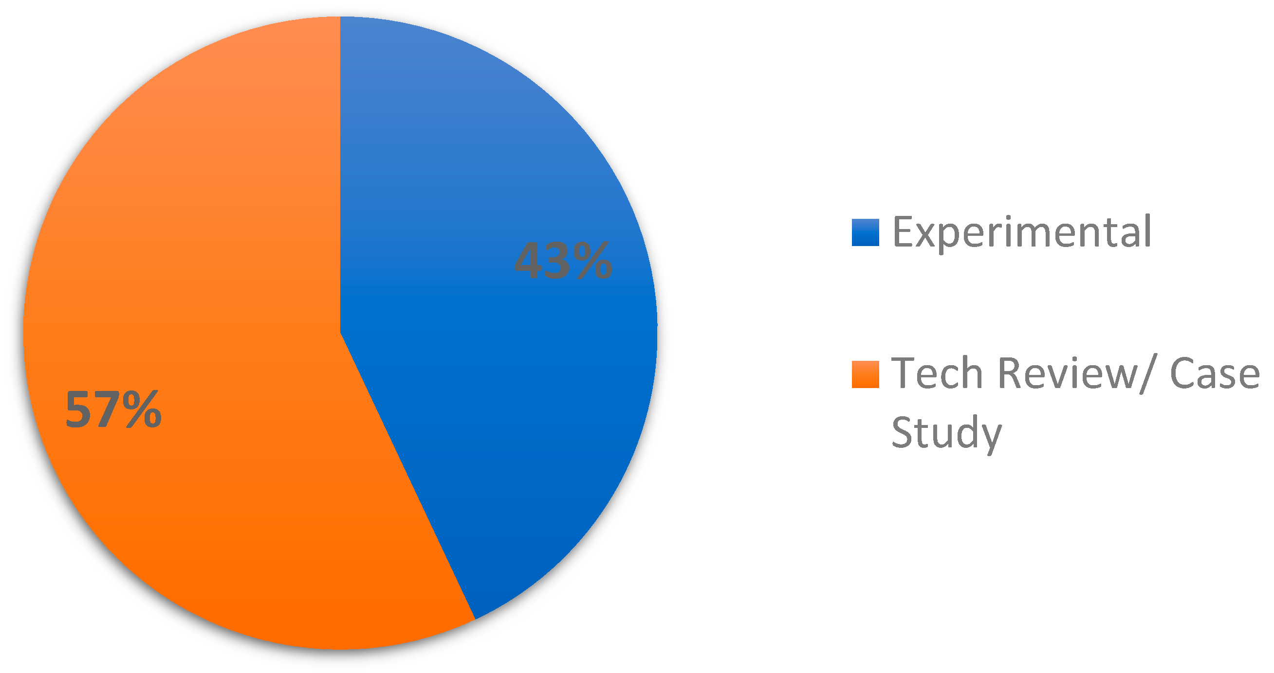
19]. There was a clear lack of experimental and scientific studies looking specifically at how earth observation technology can assist with WASH services during and after disastrous events, and although there are many studies that look at applicable technology, without more targeted research there cannot be the fundamental interventions that could transform the way that WASH services are considered and managed in the context of disasters.
The research opportunities into the management of WASH services in the response and recovery phase of disasters naturally evolve as the available technology continues to advance. The availability and relative low-cost of microsatellites as a newer alternative to the classic larger-class satellites means that governments can begin to sponsor research projects using this technology more readily [
45]. Additionally, whereas previously the computers required to carry out calculations and analysis on received data from Earth observation tools would require entire rooms or buildings to store them, massively improved technology means devices such as phones and laptops are capable of the same thing today [
46]. Technological advancement does not always occur equally or at the same rate across different sectors and in some areas, it may stagnate whilst others continue to improve. This can then present its own challenges where the applications of advancement in one area is stifled by the disparity of improvement in others. An example of this is already evident in the use of Earth observation tools, where information technology has developed rapidly, leading to remote sensing data being received at a scale that threatens the capabilities of traditional processing methods [
47].
The review of the literature has highlighted a clear need for the integration of different earth observation technologies together to form a cohesive system, as opposed to using any of the technology in isolation. Satellites, UAVs or drones, and GIS each have their optimum conditions and data collection abilities, and it is when they are used in tandem that they can have the biggest impact on improving and assisting WASH during hazardous events. Satellite coverage is dependent on their orbit around the earth, and therefore there may be gaps in coverage over a certain region [
18], or their revisit time may be such that they cannot provide new images quick enough in the situations of a short event. It is also difficult to find one satellite that carries the necessary instruments or capabilities for any type of disaster [
9]. For example, one satellite may have the correct spatial resolution to capture larger scale events, but then cannot capture smaller, more localized, events. This can be mitigated by integrating UAVs into the response system, where the controllable flight path, lower operational height and higher resolution can be used alongside the wider scope of satellite imagery to provide a better, more informed, view of the situation. For example, a satellite can be used to provide a low-resolution image covering a wide surface area that enables detection of a hazard, allowing the flight path of a UAV to be mapped to provide higher resolution images, and collect more data. GIS would then be used to analyze this data and assist with the provision and planning of efficient and adequate WASH support. Whilst the integration of multiple Earth observation tools in this way would likely result in a more efficient and robust response to WASH provision in post-disaster situations, the limitations of each technology, as discussed previously, may hinder effective combination. Combined systems would have to be robust, and any necessary permissions such as for satellite image sharing or drone flight over shared boundaries would need to be proactively obtained. An example of this integration, with key considerations for each tool, is shown in
Figure 6.
Whilst the spread of literature discussed in this report does include studies with the use of at least one or more of these technologies,
Figure 6 shows that there is still a lack of studies that specifically look at how different earth observation technologies can be applied together, especially in terms of assisting with WASH in hazardous events. The scope of the literature regarding earth observation and WASH is quite limited, and there are very few that look intentionally at how WASH can be supported in disaster contexts. Of the scientific literature that does look at WASH, many of them focus only on water and the potential for earth observation in assisting with sanitation services is overlooked. It is also important to note, however, that there are a great many types of disasters and the variable resilience or vulnerability of the area in which these disasters occur means that no two situations and subsequent response are the same. However, ultimately the goal remains the same: the provision of WASH services in the immediate aftermath of a disaster and during the recovery phase. The scope of the literature that was selected for analysis was based on a selection process that reduced over 2000 papers down to 28. Whilst care was taken during that selection process to ensure that all relevant papers were included, it is possible that some may have been missed. The selection of papers identified for review was also limited by the search criteria, of which there were numerous other search string combinations, and related terms, that could have been used as search criteria however due to the time constraint of the project, this list had to be restricted. The software used to generate literature based on the search criteria—Publish or Perish—returned the top 200 results, if the search resulted in a number of related articles that was higher than 200. Again, in the interests of time this was not increased and therefore the internal hierarchical process from Publish or Perish also influenced the selection of papers available to review. Only one grey literature search string was used to try and narrow results down to only the most relevant literature, and this could be increased to widen the scope of grey literature reviewed in the future. The purpose of this project was a high-level systematic literature review to understand the possibilities presented by earth observation technology to assist WASH in the response and recovery phases of disasters. Therefore, some literature was rejected as it was too technical concerning a specific technology or system, or the application of the technology was more appropriate for the preparedness or mitigation phases of a disaster. With a longer project time frame, it may have been beneficial to look at all four stages of a disaster or to look in detail at the technology itself.
5. Conclusions
Different disasters of varying scales and impacts will require different levels of emergency response, and each will have a unique situation regarding WASH depending on how resilient and sufficient the WASH infrastructure or supplies were prior to the event, and consequently how badly they have been affected. In some cases, the impact will be small and will only require a short period of interim support before normal provision of services can resume. In extreme cases however, the impact can be so severe that it has long-term repercussions and a long period of displacement or recovery in which interim WASH support is required for the duration before services are reconstructed. The ability to provide uninterrupted adequate drinking water, sanitation and hygiene services during a disaster, and its aftermath, is vital to ensuring the survival and wellbeing of people who, in these situations, are especially vulnerable to a variety of illnesses. Emergency measures will often include many displaced people sheltering in a small, overcrowded location which is a perfect breeding ground for a host of water-borne diseases, and lack of personal hygiene can also lead to illnesses that are easily transmittable through the close contact that such close quarters enforce. Ensuring a healthy community, will increase the propensity for prompt recovery. It is also important that, if reconstruction of infrastructure is required, that it is built to be resilient, safe, and adequate.
It is evident that the technology exists that would allow earth observation tools to play an important role in assisting with WASH service protection, provision, management and rehabilitation during the response and recovery phase of disasters. The literature analyzed during this review examined using earth observation tools such as UAVs, drones, satellites, and GIS for water-related activities including monitoring the quality of surface water, groundwater sensing, and mapping or monitoring hazards. Whilst the technology and skills used to provide these services can be applied to WASH in disaster contexts, this systematic literature review has identified a clear lack of scientific studies that focus on the response and recovery phases of disasters specifically as well as a lack of studies regarding the potential use of earth observation for the sanitation aspect of WASH in general. The use of earth observation for providing early warning and risk reduction management is a well-researched area, and there needs to be a shift in focus to ascertain how the technology can be applied to all aspects of WASH in response and recovery.
Reviewing the relevant literature highlighted that the most effective and comprehensive solutions would require a combination of earth observation technology used at different points in time, or for the procurement of different data. For example, satellites can be used to obtain a wider area view at a lower resolution to identify an impacted area, and then an UAV can be flown over that specific area to obtain higher resolution images. A deployable prototype of a cohesive system could be the focus of a future primary research project and would also help to identify any limitations to combining the different tools. Assessing case studies and gathering learnings from these examples could also be an additional piece of work to build of the conclusions drawn from this study.
There is a clear need for more research into how earth observation tools can assist with WASH during hazardous events. Scientific research is often restricted by access to funding and political influence, which can limit the scope of studies being undertaken regarding WASH in hazardous events. The unique nature of disaster impacts is a consideration, as many studies will look at one situation, the outcome of which may not be applicable across many different disaster contexts. However, as more research is applied to single situations, the greater is the likelihood that concepts can be proven and that theoretical ideas can be taken forward by different agencies. This project looked specifically at response and recovery phases, although earth observation can be used to provide continual support and monitoring of WASH services, which can potentially lessen the severity of any disaster impact; therefore, further research reviewing scientific literature using broader search criteria may be useful. This project also focused predominantly on scientific literature, so a similar review could be carried out that focuses solely on grey literature to ascertain if different requirements are identified and the subsequent potential application for earth observation tools to be used for WASH assistance. It is also possible that a cross-subject literature review may provide a wider depth of research; as WASH is integrally linked to health, especially in disaster contexts, there may be literature where the provision of WASH in disaster contexts is discussed or researched but because the literature outcomes were focused on health perspectives, this literature may not be identified in a solely WASH focused literature search. It is also worth noting that the conclusions drawn from this study are directly related to the literature analyzed, therefore additional search strings and literature may allow additional conclusions to be reached.


