Article

Land Suitability Planning for Sustainable Mango Production in Vulnerable Region Using Geospatial Multi-Criteria Decision Model

1
Department of Soil and Water Conservation Engineering, Dr. DY Patil College of Agricultural Engineering and Technology, Talsande 416112, India
2
Department of Soil and Water Conservation Engineering, Dr. Annasaheb Shinde College of Agricultural Engineering, Mahatma Phule Krishi Vidyapeeth, Rahuri 413722, India
3
Department of Soil and Water Conservation Engineering, College of Agricultural Engineering and Technology, Anand Agricultural University, Godhra 389001, India
4
Department of Soil and Water Conservation Engineering, College of Agricultural Engineering and Technology, Dr. Balasaheb Sawant Konkan Krishi Vidyapeeth, Dapoli 415712, India
5
School of Soil Stress Management, National Institute of Abiotic Stress Management, Baramati 413115, India
*
Author to whom correspondence should be addressed.
Sustainability 2023, 15(3), 2619; https://doi.org/10.3390/su15032619
Submission received: 7 December 2022 / Revised: 18 January 2023 / Accepted: 29 January 2023 / Published: 1 February 2023

Abstract

:
The land suitability in the Ratnagiri district (India) for mango crop has been assessed using a combination of multi-criteria decision making (MCDM) with GIS-based analytic hierarchy process (AHP), and sensitivity analysis. Five criteria are applied in this study to analyze land suitability affecting the mango production, viz., topography, climate, soil properties, soil erosion risk, and soil and water conservation practices, all affecting mango production. To prepare the land suitability maps for the mango plants, weights of criteria were identified through expert opinions and a pairwise comparison matrix. A weighted overlay tool available in ArcGIS software was applied in this study for the weighted overlay analysis. The most sensitive parameters were identified by developing and testing a total of 26 weighting schemes. After analyzing the sensitivity of parameters, the parameters related to soil and erosion such as terracing, contour trenching, stone bund, etc. were found as the most significant factors, before and after implementing the conservation measures. As a result, it was observed in this study that after conservation practices were implemented, the area in the highly suitable (19.4%) and moderately suitable (68.8%) classes was expected to rise, while the area in the marginally suitable (7%) class was expected to decrease. This research revealed that combining MCDM with GIS-based AHP as well as sensitivity analysis techniques increased the reliability of MCDM output for each criterion.

1. Introduction

Land and water resources are limited and used extensively, and a continuing human population growth without supporting food production growth rate is resulting in a decline in global land resources health and productivity. The estimates suggest that globally about 24 bt (billion tonnes) of land is lost each year due to water erosion that exceeds the rate of naturally regenerated soil. According to estimates in India, erosion affects approximately 53% of the country’s total area, and 4.87 bt of soil are lost yearly [1]. In Maharashtra, an approximate 773.5 million tonnes (MT) of soil are detached per year, with water-induced erosion accounting for 94% of that total [2]. The Konkan region is experiencing 119.84 million tonnes of soil loss per year [3]. As a result, it is critical to plan and implement appropriate soil water conservation practices in order to identify erosion-prone areas and estimate soil loss rates with greater accuracy.
Accelerated erosion is also increasing emissions of greenhouse gases (GHGs) and carbon dioxide (CO2) levels in the atmosphere. The rapid and uncontrollable growth of agroecosystems to feed the rising population, on the other hand, is driving the issue of accelerated erosion. Furthermore, man-made global warming exacerbates the soil erosion problem [4]. GHG emissions have a negative impact on the global environment. Carbon sequestration (CS) to reduce emissions of GHGs is the most commonly used method [5]. The issue of rising carbon emissions is a global concern, which is addressed by Kyoto Protocol [6]. Carbon sequestration in agriculture implies the capacity of agriculture, forest lands, and horticulture lands to absorb atmospheric carbon dioxide. Trees flowering and fruit production capabilities remove carbon from the atmosphere and store it [7]. As a result, due to present agricultural expansion, the high rate of poverty, and the decrease in forest land, orchards can contribute positively to sustainable growth in climate change in tropical areas [8]. Soil carbon sequestration has multiple strategies, such as restoring degraded soils, increasing land productivity, protecting the environment, and reducing rising atmospheric CO2 [9]. Thus, establishing a relation between soil erosion and soil carbon as carbon sequestration would be a good platform for better planning of soil water conservation practices in the watershed.
Land suitability evaluation is imperative to developing strategies to achieve maximum agricultural outcomes by defining its inherent possibilities as well as limits [10] and long-term improvement in sustainable crop production. It is essential for decision-makers to evaluate lands in terms of their production capacity and suitability to grow various crops in order to better utilize these lands and cultivate crops that will achieve the highest productivity. There are various methods developed to evaluate and classify land capability such as FAO, (1976) [11]. The main objective of this method is to evaluate land capability and classify it into several quality categories. Land suitability for cultivating various crops can be assessed using various methods based on soil parameters, climate data, crop-requirements data, erosion risk, topography, etc. Recently, specialists have been formulating criteria-based assessments of suitability for agricultural land using MCDM [12] to expand the decision-support capabilities of GIS. GIS is an effective method for storing, retrieving, processing, and analyzing spatial and time data required for multi-source spatial planning and management. GIS does not consider the priorities of criteria because not all criteria are of equal importance [13]. To overcome this problem, MCDM techniques are being created in the geospatial field to enhance GIS decision-making capabilities for handling multiple factors [14]. Analytical hierarchy process (AHP) is one which is widely used as a MCDM technique with GIS [15] due to its applicability to take decisions based on various factors rated as per experts’ priorities [16,17]. Hence, study on the suitability of land must be done in order to incorporate community needs and conditions in final decisions [18].
The top five mango growers in the world are India, China, Thailand, Indonesia, and Pakistan. In terms of area and production, India is the world’s largest mango producer (nearly 50%) [19]. Mangoes yielded 18,431.3 thousand MT in India, with an area of approximately 2516 thousand ha and 7.3 Mt/ha productivity [20]. Globally, mango production in India contributes about 41%. Mango occupied approximately 485 thousand ha area with yearly production of 1212.50 thousand MT at 2.5 MT/ha productivity in Maharashtra [21]. Mango cultivation occupied 100 thousand ha of productive land in Konkan, with a 50 thousand MT annual production and 3.12 MT/ha productivity [22].
In Konkan region, mango is a major perennial plant. While mango is world famous for its aroma, it faces the challenges of lower productivity and uncertainty in production due to various factors [23]. Poor mango orchard efficiency and yearly variations in the mango crop are considered long-term barriers to mango cultivation in Konkan. These factors are not studied in a holistic way yet; advanced techniques of MCDM with currently available databases would be a prudent step in sustainable development of ecologically sensitive mango crop of Konkan region. Konkan is endowed with ample natural resources such as soil, water, and vegetative cover. However, because of its unusual climatic conditions and uneven topography, its vulnerability as a biodiversity hotspot [24] is well known. It causes a significant loss of land and water through runoff. Inappropriate utilization of land surface and water resources, runoff, and topsoil loss all contribute to the depletion of soil organic carbon, lowering the quality and fertility of topsoil, and increasing soil erosion. This overall decline in land productivity is the result of poor planning of soil and water conservation practices. Thus, it is required to evaluate the land suitability in Konkan region.
In present land suitability applications, AHP has consistently been used as a GIS-based evaluation system. The authors assigned weights to five main criteria using expert preferences: climate, soil, slope, erosion risk, and conservation measures. Most of the previous land suitability studies concentrated on soil, erosion risk, climatic factors, and environmental factors [25,26,27,28,29]. Soil erosion data supports the reduction of soil degradation through conservation planning. Hence, it needs to plan and implement suitable soil and water conservation (SWC) practices to identify the erosion-prone areas. Therefore, it increases the capacity of soil to hold water, nutrients, and organic matter, thus improving the soil organic carbon storage and productivity of the soil. Erosion causes degradation of the soil structure and reduces soil moisture-holding capacity by lowering soil depth, and reducing water infiltration capacity. Hence, such conditions create the potential for conservation works. Thus, the present study focuses on evaluating the impacts of land suitability before and after implementing soil water conservation measures. Soil and water conservation measures improve land productivity and also increase carbon sequestration. These new techniques for land suitability planning can be a boon to horticulture in general and to mango in particular in the Konkan region where productivity improvement is considered as a major challenge. Thus, the present study presents the new approach for using a geospatial multi-criteria decision model to plan the suitability of land in the Ratnagiri district for mango production.

2. Materials and Methods
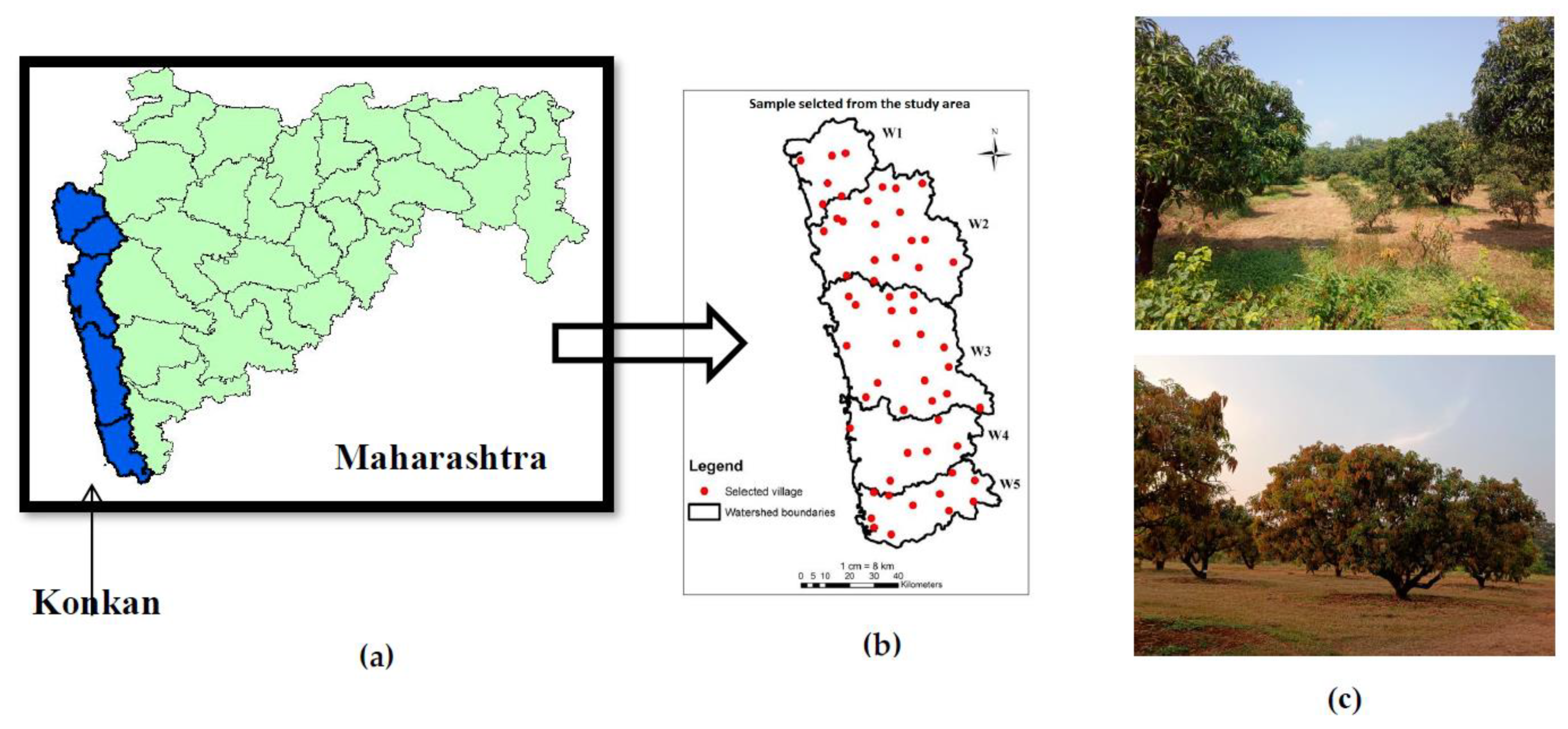
2.1. Study Area

Ratnagiri is a Maharashtra coastal district on India’s western coast. The Ratnagiri district is situated between latitudes 16°30′ and 18°5′ N and longitudes 73°2′ and 73°52′ E. The Ratnagiri district was split into five watersheds (viz., W1, W2, W3, W4, and W5), which cover an area of 8459 sq km and receive an average annual rainfall of 3591 mm (Figure 1). Rice is the district’s main staple food, followed by finger millets and proso millets, which are primarily grown during the Kharif season. The area under Kharif season is approximately 115,899 ha, which includes rice and millet crops, while the area under the Rabi season is approximately 2640 ha, which includes oilseeds and other crops. The main fruit crops in the study area are horticulture crops like mango, cashew, coconut, and areca nut.

2.2. Satellite Data

Satellite data such as LANDSAT images and SRTM data were used for the preparation of GIS layers (LULC map, slope map). Land use and land cover data were collected from MRSAC Nagpur, but the forest class included areas under the forest and orchard classes. So, LANDSAT 8 data with 30 m resolution for the year 2018 was downloaded (LC08_L1TP_147048_20181126_20200830_02_T1) from USGS Earth explorer (https://earthexplorer.usgs.gov/ accessed on 16 January 2019) and used for the separation of a particular class of horticulture. From this LANDSAT 8 data, bands 5 (near-infrared), 4 (visible red), and 3 (visible green) were used to prepare false color composites (FCC) to perform image classification using supervised classification techniques. For supervised classification, a signature file for horticultural classes was created using training samples through image classification, and horticultural class was extracted from the forest class. Digital terrain model was downloaded from SRTM (http://.srtm.csi.cgiar.org accessed on 27 January 2019) to prepare a slope map.

2.3. Data Collection from Field

A total 258 soil samples from 58 villages of the Ratnagiri district were collected, which has the highest concentration of mango plantations. The analysis of physical and chemical properties (OC, BD, textural data (sand, silt, clay)) of soil samples was done in a soil laboratory, and GIS interpolation tools were used for the preparation of various maps. For effective soil sample data collection, the entire study area was divided into small grids of 10 km × 10 km. Thus, a total of 58 villages were selected for data collection (Figure 1). The study was conducted for mango orchards, where the girth of tree measured 1.37 m above the ground level to an estimation of the biomass and carbon stock [30] of mango crops in the Ratnagiri district. In the study area, daily minimum and maximum temperature (Tmin and Tmax) (1988–2019), and daily rainfall data (1998–2019) were used.

2.4. Method

The universal soil loss equation (USLE) was used to assess the annual average soil loss in the Ratnagiri district [31]. The various previous researchers estimated soil loss using USLE [32,33,34]. The carbon loss estimation is based on soil erosion, SOC, and values of carbon enrichment ratio (CER) [1]. The different soil water conservation practices were recommended in the study area according to the climatic, topographic, and soil characteristics [35,36,37], along with their respective rate of carbon sequestration [38]; a carbon sequestration map was prepared.

2.4.1. Multi-Criteria Decision Making (MCDM)

Multi-criteria decision making (MCDM) is a field of operations research that clearly analyzes conflicting criteria in strategic planning. Decision making in land-use planning, risk management, and many other scientific as well as practical problems is generally influenced by possible multiple factors/criteria for their evaluation. It is difficult to obtain the solution without use of decision analysis. Decision support is a term used in deciding the results. Usually, it determines the optimal solution of problems from multiple criteria with their multiple potential solutions. The main advantage of the MCDM method is it describes the relationship between input and output maps [39]. It implies the use of geographic information and the priorities of decision makers, and accordingly, it is used as per decision rules. MCDM is a process that combines and transforms geographic information into decisions [18] and is used to solve decision-making problems by imitating multiple criteria.

2.4.2. Analytical Hierarchy Process (AHP)

AHP is a popular decision-making method commonly used in various fields [29,40]. Most of the previous studies have used MCDM and AHP methods along with GIS for land suitability studies [41,42,43,44]. AHP is based on the basic assumption that comparing two components is dependent on their relative significance [45]. It is a multi-criteria decision-making approach used to solve multifaceted problems [46]. It computes weights for criteria maps using a pairwise comparison matrix. The pairwise comparison matrix explains the importance of each factor that influences others. A comparison scale with values between 1 and 9 (equally to extremely important) describe the degree to which they are important to each other [47]. Based on similar climatic conditions, the opinions of plant specialists, and the availability of mango requirement data from previous studies, evaluation criteria were developed [26,42,48]. Identifying the best land-use class for the study area entails combining information from different parameters that influence mango crop production. In the current study, five main criteria (slope, climate, soil, erosion risk, and conservation measures) and 11 sub-criteria were chosen for analysis (rainfall, Tmin, Tmax, slope, BD, soil texture, OC, erosion, C-loss from soil loss, conservation measures, and carbon sequestration) were undertaken for land suitability of mango [25,49,50,51,52,53]. The consistency of decisions in scoring the criterion determines the accuracy of the measured weights in the pairwise comparison matrix. The consistency ratio (CR) assesses the consistency of decisions and identifies potential errors. CR measures how much variation is allowed in acceptable outcomes, which is usually 10% or less to proceed with AHP [28]. Hence, if the CR value exceeds the upper limit of 10%, it is recommended that the pairwise comparison matrix be modified to improve decisions. The data on suitability of Mango crop cultivation was summarized into four categories: highly suitable (S1), moderately suitable (S2), marginally suitable (S3), and not or unsuitable (N) classes [11]. Thus, all these criteria maps were prepared by GIS tool and AHP method by considering mango crop requirement (suitability of mango crop). Weighted overlay tool was used in ArcGIS to prepare suitability map for mango crop.

2.4.3. Sensitivity Analysis (SA)

It is an assessment of the impacts of changes in model input values on model outputs [54,55]. The main aim of SA is to evaluate the sensitivity of the model to change the value for every parameter while keeping other parameters constant. It helps in the model to understand the uncertainties which are associated with model parameters. In AHP, it is a widely useful method for estimating criteria weights in multi-criteria decision making via expert pairwise comparison matrix. For this purpose, SA supports the MCDM techniques for validation and calibration [56,57,58]. In the present study, sensitivity analysis used with different scenarios was applied for each criterion. Therefore, in the present study, 26 weighting arrangements were created, tested and analyzed in ArcGIS.

3. Results and Discussion

3.1. Preparation of Various Thematic Maps

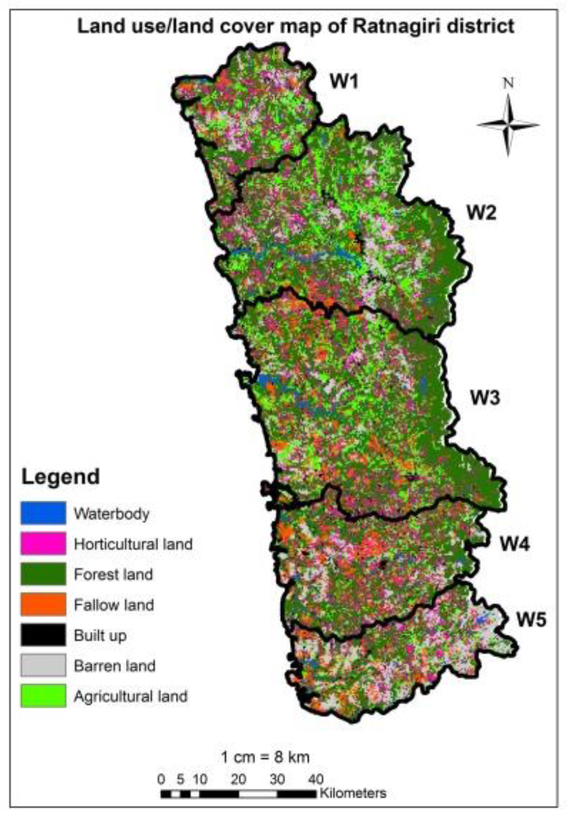
3.1.1. Land Use/Land Cover Map

The land-use cover (LU/LC) map of the Ratnagiri district was divided as waterbody, barren land, forest, fallow land, built up, agricultural land, and horticulture land. Figure 2 depicts the LULC map of the Ratnagiri district. The land coverages in the Ratnagiri district which fall under major three classes, i.e. forest, horticulture and agriculture, was 77.21%. This shows dense vegetative cover over the Ratnagiri district. The large portion is also under barren land/cultivable wasteland which can be effectively brought under mango cultivation with proper practices.

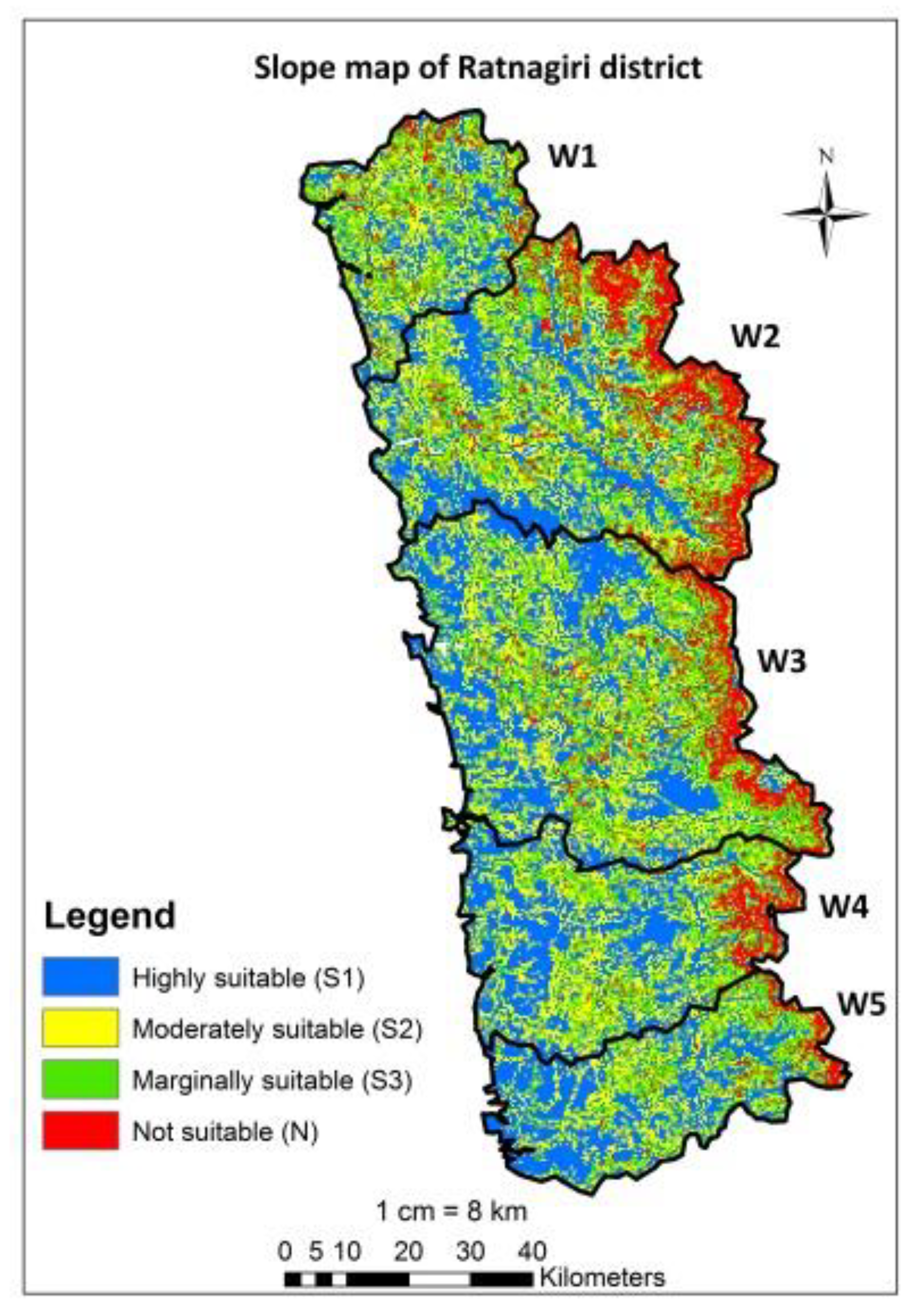
3.1.2. Slope Suitability

Agricultural production is greatly influenced by slope, which is the main parameter in mango cultivation. A slope range between 0 and 16% is a highly to moderately suitable class for mango (Table 1). Figure 3 illustrates the slope map of the Ratnagiri district. Approximately 66% of the land is classified as highly to moderately suitable. Because of the steep slope (>30%), approximately 10.76% of the land is unsuitable for mango production. As a result, the unsuitable area was mainly on the eastern portion of hilly terrain in the Ratnagiri district.

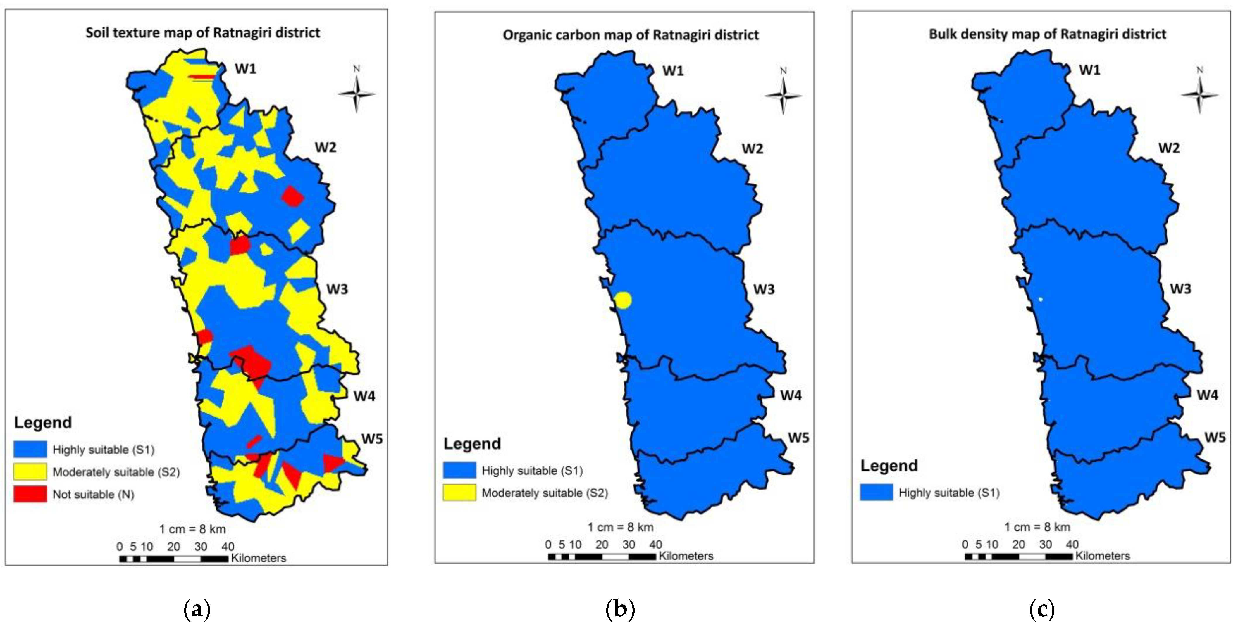
3.1.3. Soil Suitability

Mango cultivation requires well-drained soils. Mango is grown in laterite soil and alluvium in India. The ferruginous red soil type from Dharwad and Belgaum, Ratnagiri (Konkan), and Goa is ideal for mango cultivation [59]. A soil texture map of the Ratnagiri district was shown in Figure 4a. As per the soil texture map, approximately 53% of the land is under highly suitable as it is loamy sand, and 42.40% is moderately suitable for mango. The soils in the area are sandy loam, loamy sand, and sandy clay loam, which are well-drained and suitable for fruit trees.
Mango field soils in Konkan are generally high in OC. The concentration of OC in the study area ranged from 0.60 percent to 2.69 percent. Figure 4b shows that the soils are high in OC. According to [60] ratings, the organic carbon in Konkan lateritic soils is very high. Previous research also found very high OC in the mango fields of the Ratnagiri district [61,62,63].
The bulk density of soil is an indicator of its densification, quality, and drainage condition. It has an impact on root depth, capability of water retention, voids, and nutrient levels. As shown in Figure 4c, a bulk density map shows that 100% of the area in the Ratnagiri district was highly suitable.

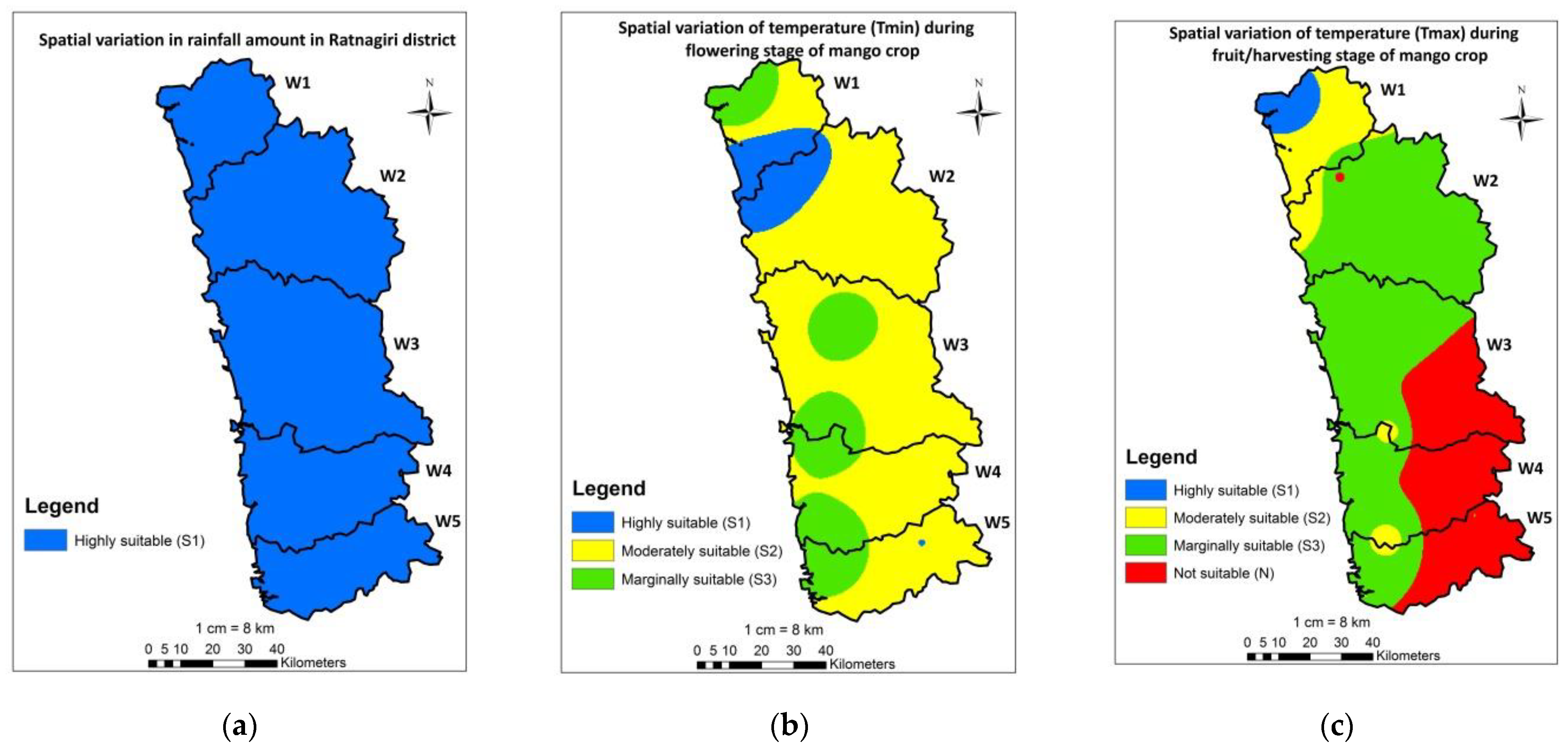
3.1.4. Climate Suitability

Rainfall amount and distribution are both very important in mango cultivation. Although mango is grown in low as well as high rainfall (2500 to 3000 mm) regions, rain in the time of fruit development and maturation can be damaging, increasing the risk of disease, and deteriorating the quality of the fruit. Mango production areas like the Konkan region in India have high rainfall during the dry season, which is essential for proper floral induction and mango fruit development. The rainfall analysis of the Ratnagiri district revealed that the rainfall pattern in the area is highly suitable for mango production. Figure 5a depicts the spatial rainfall distribution. Temperature is the main factor that influences the growth cycle, time and frequency of flowering, fruit growth, taste, and appearance of the mango in most of production areas [64]. The flowering period is the most important feature controlled by climatic condition. Thus, mean min. and max. temperature during the flowering and fruit/harvesting stage is important for mango production. The mean minimum temperature of 13 °C to 17 °C is considered as highly suitable, whereas temperatures of 17 °C to 20 °C are considered as moderately suitable in the flowering phase (Table 1). The classified mean minimum and maximum temperature maps of the Ratnagiri district were shown in Figure 5b,c, respectively. In the flowering season of mango, 80% of the land was found to be highly to moderately suitable. Similarly, in the fruit growth period of the mango crop, 14.17% of the land is highly to moderately suitable.

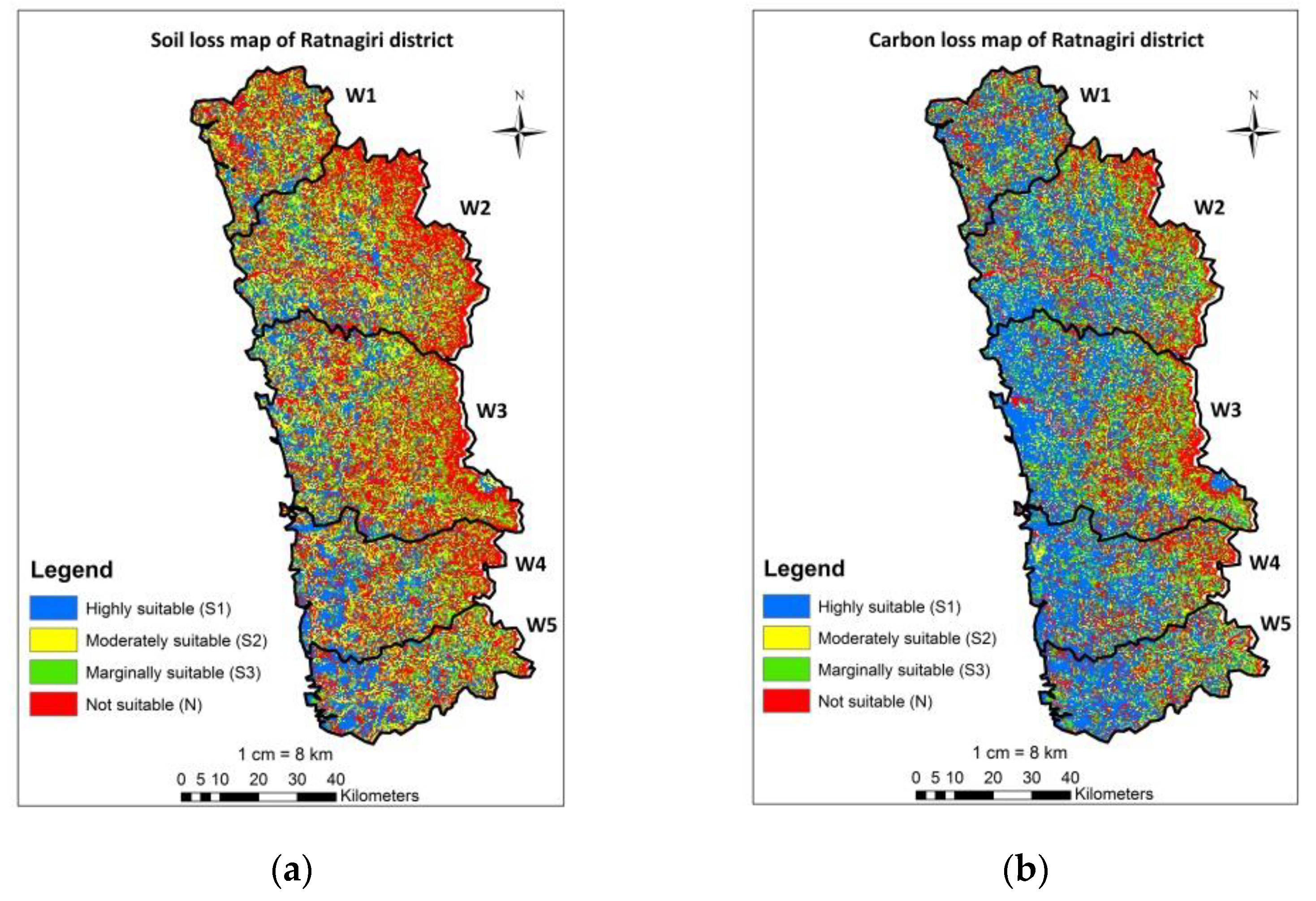
3.1.5. Soil Loss and Carbon Loss Suitability

Mango fields in India are facing severe topsoil erosion. It degrades the structure of the soil, decreases water retention capability, decreases soil nutrients, and reduces soil depth, all of which decrease the soil’s productivity [65,66]. ArcGIS software was used to create all the layers (R, K, LS, C, and P). Annual average soil loss from the Ratnagiri district was 37.80 t/ha. As shown in Figure 6a, approximately 42% of the land falls into the highly suitable to moderately suitable (<20 t/ha/yr) category. Approximately 36.41% of the land is unsuitable for mango production due to very severe erosion (>40 t/ha/yr). It is important to implement different conservation practices to reduce erosion and convert unsuitable land into suitable land for mango cultivation.
Accelerated soil erosion is a major environmental issue, resulting in significant soil organic carbon loss. Soil particle detachment, transportation, and deposition all have a distinct impact on SOC [67], which varies with physical, chemical, and microbial environment. Figure 6b depicts the spatial distribution in carbon loss of the Ratnagiri district. According to the findings, about 54.39% of the land is highly to moderately suitable, while the remaining 22.64% is unsuitable due to the severe loss of carbon. As a result, as the rate of soil erosion increases, the rate of carbon loss also increases.

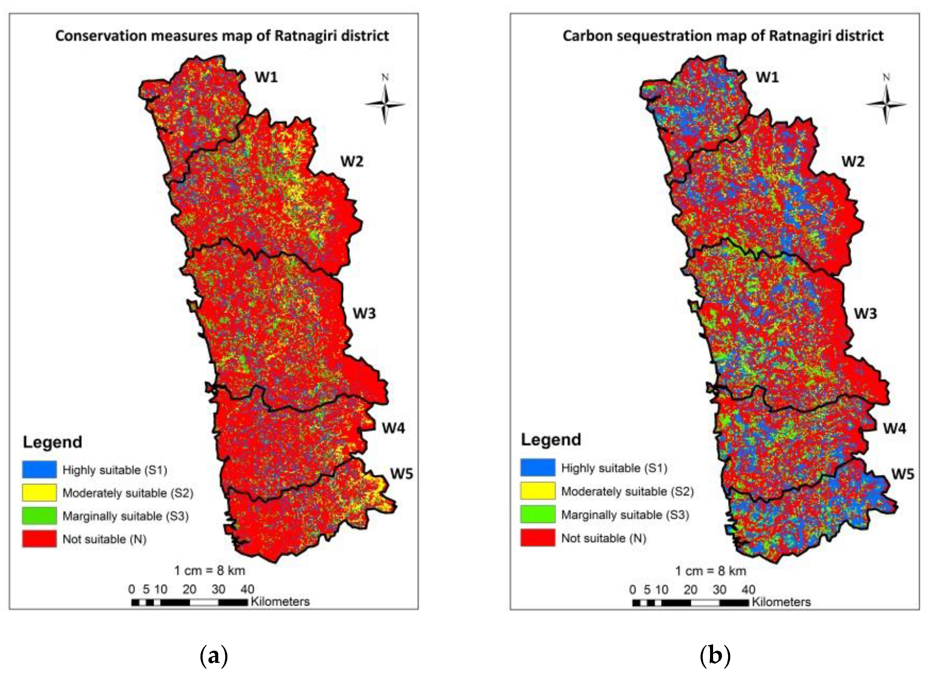
3.1.6. Soil and Water Conservation Measures

Mango productivity is increased by soil water conservation practices. Mango can be grown in wastelands, low fertility soils, and drylands [68]. Mango is considered a primary crop for converting wasteland through the design and planning of watersheds. Various soil water conservation measures (SWC) are suggested in this study based on climate conditions and the topography of the land [35,36,37]. According to the SWC measurements, 22% of the land has been highly to moderately suitable for mango cultivation, as shown in Figure 7a. Approximately 4.75% of the land is classified as permanently unsuitable, which involves water bodies, built-up areas, and rocks. Likewise, approximately 71.17% of the land is currently unsuitable due to land with hilly areas (slope > 20% and covering about 24.78% of the total area) with the greatest erosion. Approximately 36.41% of the area suffered major soil erosion. Hence, heavy rainfall and undulating terrain reduce nutrient availability. Although this land is currently unsuitable, it can be converted into a suitable one through proper planning of different practices.

3.1.7. Carbon Sequestration

Carbon sequestration by trees in the form of biomass and soil carbon stock is a tool for assessing the ecological and sustainable impact of carbon on natural ecosystems. Carbon sequestration is a potent tool to mitigate the carbon dioxide concentration from the atmosphere. The rate of carbon sequestration from tree or fruit plantations is significantly affected by the choice of vegetation types, type of soil, climatic condition, geography, and tree density [5]. Mango cultivation needs special attention because it is the most important fruit tree in India and occupies the most land. Thus, suitable land management by recommending different soil water conservation measures which reduce soil erosion has significant climate benefits for improving carbon sequestration.
The carbon sequestration map was shown in Figure 7b, which indicates that 29.95% of the land was highly suitable, with 1.36% and 10.81% being moderately and marginally suitable for mango, respectively. Likewise, 53.13% of areas were classified as currently unsuitable, while 4.75% were classified as permanently unsuitable. This currently unsuitable land can be transformed into suitable through the planning of different management strategies that enhance carbon sequestration.

3.2. Mango Crop Suitability Map Using AHP

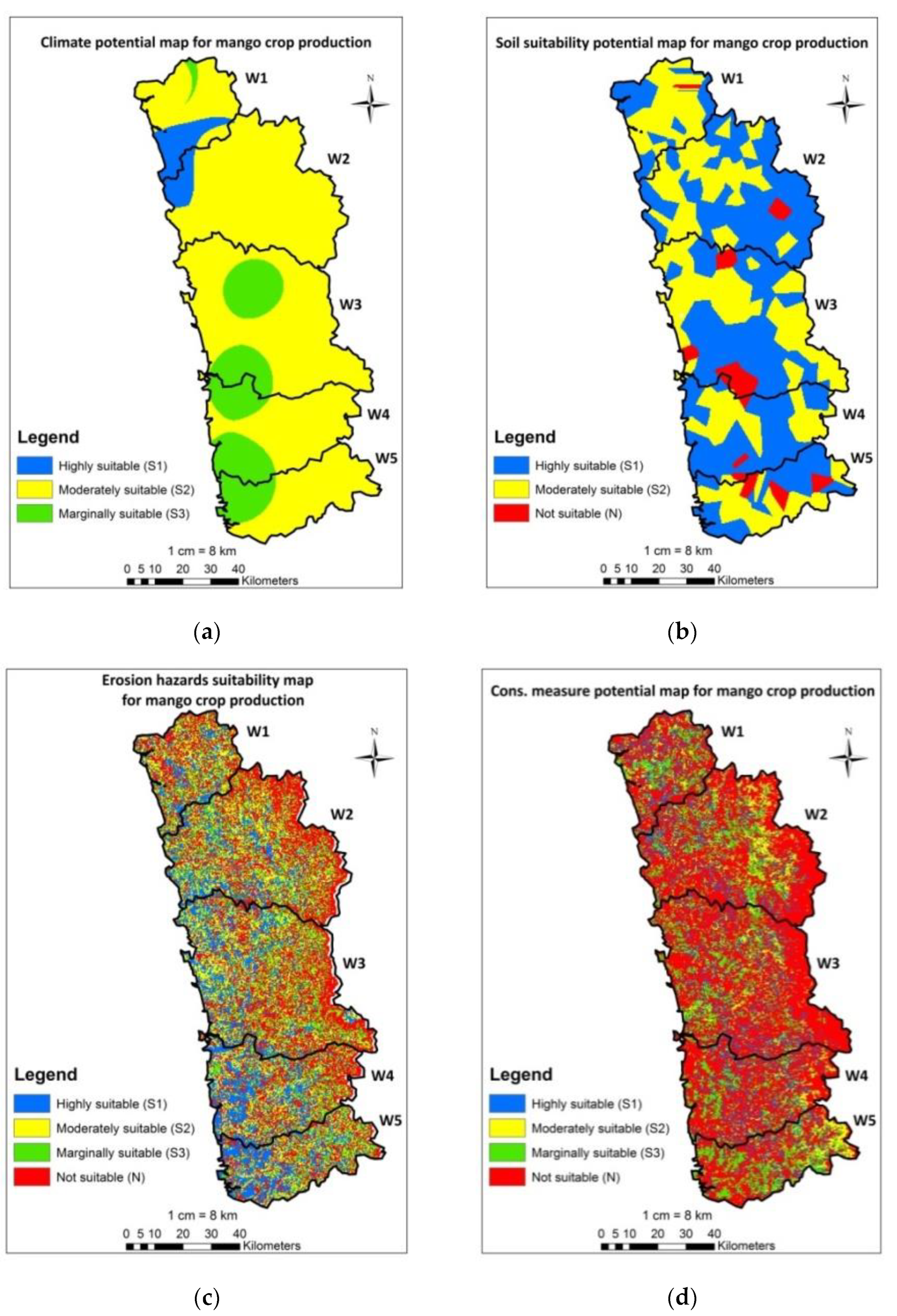
3.2.1. Mango Climate Suitability Map

By superimposing maps of rainfall and temperature criteria, a climate suitability map for mango cultivation was created (Tmax and Tmin). According to the analytical hierarchical process (AHP), minimum temperature has the largest effect (63%), as shown in Table 2. Based on the findings, 4.68% of the land was classified as highly suitable for mango production, 78.33% was moderately suitable, and 16.99% was marginally suitable. Figure 8a depicts a climate potential map for mango production in the Ratnagiri district.

3.2.2. Mango Soil Suitability Map

By superimposing maps of soil texture, organic carbon, and BD criteria, a soil suitability map for mango production was created. According to the AHP, soil texture has the largest effect (54%), as shown in Table 2. From the findings, about 52.92% of the area was considered to be highly suitable for mango production, 42.44% was moderately suitable, and 4.64% of land was unsuitable. Figure 8b depicts a soil potential map for mango production in the Ratnagiri district.

3.2.3. Mango Erosion Hazards Suitability Map

Overlapping maps of soil loss and carbon loss resulted in the potential erosion risk map. Table 2 presents the findings of the AHP, which reveal that soil loss is the most significant factor, with a 75% influence. According to the findings, approximately 24.48% of the land in the Ratnagiri district was highly suitable, 21.24% was moderately suitable, 19.27% was marginally suitable, and 35.01% was unsuitable for mango production. Figure 8c depicts the outcomes of the AHP approach for erosion hazards.

3.2.4. Mango Conservation Measure Suitability Map

Overlapping maps of conservation measures and carbon sequestration resulted in the conservation measure suitability map. Table 2 shows that using the AHP, conservation measures get the greatest influence, with a 67% influence. The outcomes indicate that approximately 16.54% of the areas in the Ratnagiri district were highly to moderately suitable, 17.14% were marginally suitable, and 66.32% were currently unsuitable for mango cultivation (Figure 8d).

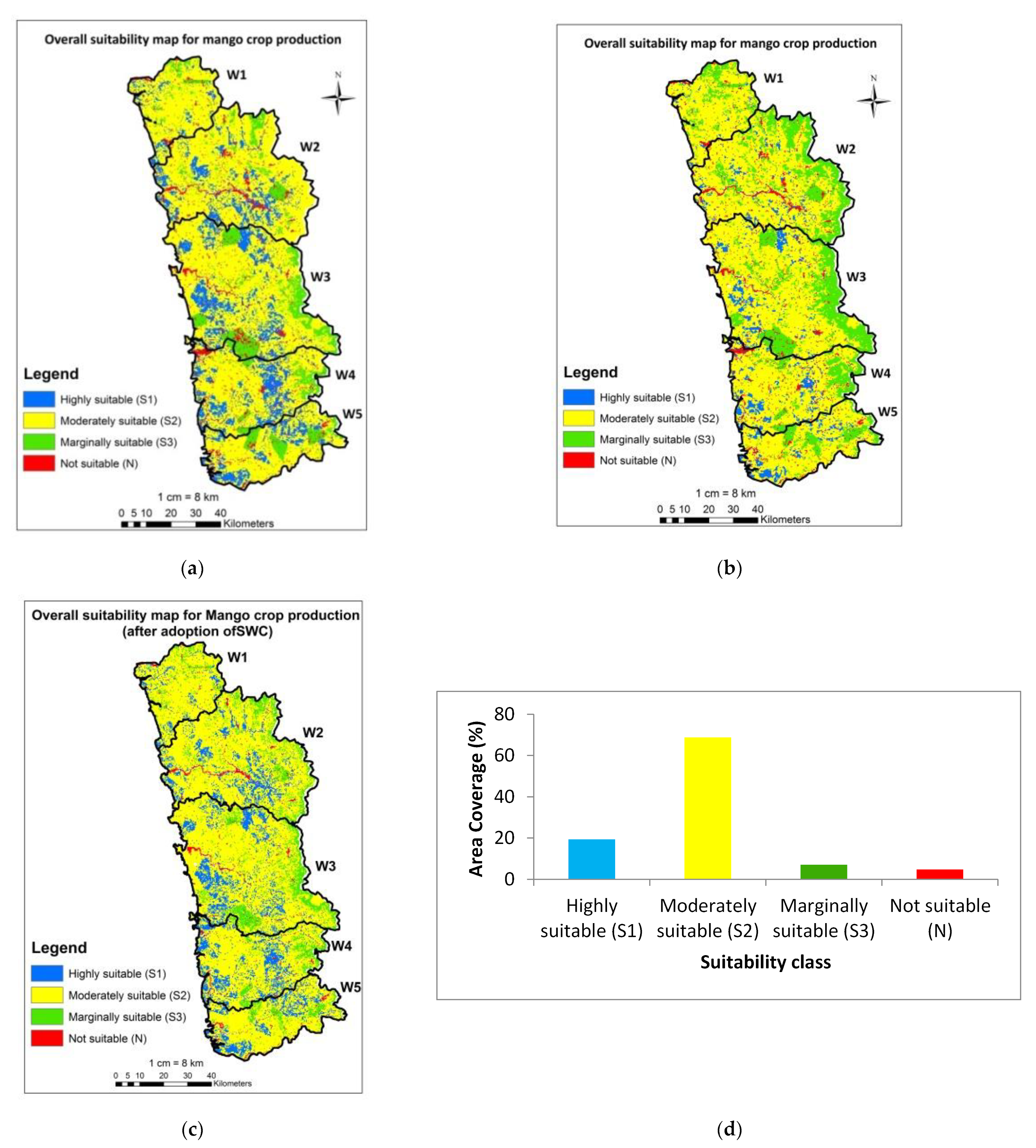
3.2.5. Overall Mango Suitability Map Using Main Criteria

The final suitability map was created by using the weighted overlay technique in ArcGIS by superimposing suitability maps of soil, slope, climate, conservation measures, and erosion. The weight value of each main criterion was calculated using AHP, and Table 2 shows soil to be the most significant factor, with a 50% influence. Figure 9a depicts the overall mango suitability map for the Ratnagiri district based on the main criteria. The output of study indicates that approximately 84.76% of the land was classified as highly to moderately suitable, 10.03% as marginally suitable, and 5.18% as currently unsuitable for mango cultivation.

3.3. Sensitivity Analysis

3.3.1. Before Adoption of Soil and Water Conservation (SWC)

The sensitivity analysis indicates that soil and slope criteria had a significant impact on the highly suitable (S1) class. The weight for each criterion was determined based on variations of function by dividing the variance value of each criterion by the total variance (Table 3). The most important factor is the soil, followed by slope, erosion, conservation measures, and climate. As similar studies showed, soil is an important parameter in mango crop followed by slope and then erosion risk [27].

3.3.2. Overall Mango Land Suitability Map Using Sensitivity Analysis

The overall mango suitability map revealed that 749.92 km2 (8.86%) areas were highly suitable, 5420.58 km2 (64.08%) as moderately suitable, 1871.04 km2 (22.12%) as marginally suitable, and the remaining area, 417.46 km2 (4.94%), was unsuitable for mango (Figure 9b). Mango cultivation on barren and fallow land is possible with intensive conservation measures and irrigation techniques. As a result, marginally suitable land can be transformed into moderately suitable land through the implementation of conservation measures such as drainage and irrigation techniques.

3.4. Accuracy Assessment

There were a total of 112 ground reference points collected from the study area and compared with classified suitability data. In the present study, the accuracy was estimated using the Kappa coefficient, and the results indicated the excellent accuracy of 0.87 which showed that it is an effective method of assessment of accuracy.

3.5. Spatial Variation in Soil Loss after Implementation of SWC

The average annual soil loss in the Ratnagiri district was measured after implementation of soil water conservation measures. The results revealed that approximately 90% of the areas are highly suitable to moderately suitable, while the remaining 3.17% is unsuitable due to severe soil loss (>40 t/ha/yr). Thus, results when compared before and after conservation measures, found that the highly suitable area increased from 23.53% to 75.38% after implementing conservation measures. Similarly, the area under moderately suitable was reduced from 18.38% to 15.04% after conservation measures. It was also discovered that the area found as marginally suitable was reduced from 21.68% to 6.41%. C loss followed a similar pattern.

3.5.1. Sensitivity Analysis after Implementation of SWC

Thus, following the implementation of SWC, 26 weighting schemes were run again using soil loss and carbon loss. The results revealed that soil loss is the most important parameter followed by soil, slope criteria, conservation measures, and climate after SWC recommendation.

3.5.2. Overall Mango Land Suitability Map (after Implementation of SWC)

The overall suitability map after implementation of soil and water conservation measures for mango crop production was shown in Figure 9c. It showed that 19.37% of the area was determined to be highly suitable, 68.79% as moderately, 7.00% as marginally, and 4.83% to be unsuitable for mango crop. Thus, by comparing overall suitability map as use of soil loss before and after SWC measures, it is seen that the area under the highly suitable class can be increased by 19.37% as compared to 8.86%. Similarly, the area in moderately suitable increased by 68.79% compared to 64.08%. It was also discovered that the area in marginally suitable was reduced from 22.12% to 7.00% after conservation measures were implemented. Hence, it is expected that, after implementation of conservation measures, marginally and moderately suitable land will be converted into highly suitable land.

4. Conclusions

In this study, a multi-criteria decision-making (MCDM) model with geographic information systems (GIS) was used to predict mango crop suitability in eco-sensitive zones in Konkan region of Maharashtra. Analysis was done by using MCDM tools which showed about 8.86% area is highly suitable, 64.08% moderately suitable, 22.12% marginally suitable, and 4.94% unsuitable for mango cultivation in the Ratnagiri district before adoption of SWC. Sensitivity analysis showed that soil parameter was the most important factor before SWC. Although, erosion was another crucial factor followed by soil, slope, conservation measures, and climate after SWC; it is expected to increase the area under the highly suitable class up to 19.37%. By Kappa analysis, the Kappa coefficient was found as 0.87, as these results match the area under mango crop up to 90.18% (overall accuracy). Hence, the study showed that MCDM with GIS-based AHP and sensitivity analysis techniques improved the accuracy of multi-criteria decision-making output for each criterion. The mango productivity, as well as production, could be further increased by adoption of innovative soil and water management techniques. Hence, mango orchards should not be considered only to raise income but also benefits in terms of soil conservation and carbon sequestration. It will increase the income through carbon credits, although the use of high-resolution satellite images will help in the assessment of finer details. As erosion and soil formation are continuous processes, the depth of the soil may vary in the future. The study will assist farmers, farm managers, and decision-makers in increasing the best selection of land under mango cultivation based on land suitability. The mango suitability map would assist the policy makers in implementing and developing strategic policies without hampering the local biodiversity and losses of carbon. Mango plantations with appropriate soil and water conservation measures will be suitable to reduce soil erosion and increase carbon sequestration, and could bring the area under mango cultivation as per land suitability. It helps in better planning for carbon credits at the regional level.

Author Contributions

Conceptualization, S.N.; methodology, S.N. and S.S.; software, S.S., S.N. and H.B.; validation, S.S. and M.T.; formal analysis, S.S. and S.N.; investigation, S.S., S.N. and H.B.; resources, S.S., S.N. and H.B.; data curation, S.S. and H.B.; writing—original draft preparation, S.S. and S.N.; writing—review and editing, S.B.C. and M.T.; visualization, S.N. and M.T.; supervision, S.N.; project administration, S.N. and H.B.; funding acquisition, S.S. All authors have read and agreed to the published version of the manuscript.

Funding

This research received no external funding.

Institutional Review Board Statement

Not applicable.

Informed Consent Statement

Not applicable.

Data Availability Statement

Data will be made available on request to the corresponding author.

Acknowledgments

The authors are highly grateful to the University of Balasaheb Sawant Konkan Krishi Vidyapeeth, Dapoli, Ratnagiri for carrying out this research program.

Conflicts of Interest

The authors declare no conflict of interest.

References

  1. Mandal, D.; Giri, N.; Srivastava, P. The magnitude of erosion-induced carbon (C) flux and C-sequestration potential of eroded lands in India. Eur. J. Soil Sci. 2020, 71, 151–168. [Google Scholar] [CrossRef]
  2. Durbude, D. Hydrological impact assessment of SWC measures in Ralegon Siddhi model watershed. Indian J. Soil Conserv. 2015, 43, 197–203. [Google Scholar]
  3. Nandgude, S.B.; Mahale, D.M.; Jagtap, D.N.; Rane, A.D.; Patil, V.K.; Hardikar, D.P.; Salunkhe, S.S.; Bandgar, N.N.; Mohite, N.S.; Phadtare, M.A.; et al. Natural Resources Atlas of Konkan; DBSKKV: Dapoli, India, 2018. [Google Scholar]
  4. Lal, R. Soil Erosion and Gaseous Emissions. Appl. Sci. 2020, 10, 2784. [Google Scholar] [CrossRef]
  5. Chavan, S.B.; Dhillon, R.S.; Rizvi, R.H.; Sirohi, C.; Handa, A.K.; Bharadwaj, K.K.; Johar, V.; Kumar, T.; Singh, P.; Daneva, V.; et al. Estimating biomass production and carbon sequestration of poplar-based agroforestry systems in India. Environ. Dev. Sustain. 2022, 24, 13493–13521. [Google Scholar] [CrossRef]
  6. Ravindranath, N.H.; Somashekhar, B.S.; Gadgil, M. Carbon flow in Indian forests. Clim. Change 1997, 35, 297–320. [Google Scholar] [CrossRef]
  7. Zade, S.P.; Bhosale, S.L.; Gourkhede, P.H. Carbon Status in Major Fruit Orchard Soils of Parbhani District of Maharashtra. Int. J. Curr. Microbiol. App. Sci. 2020, 9, 1969–1979. [Google Scholar] [CrossRef]
  8. Patil, P.; Kumar, A.K. Biological carbon sequestration through fruit crops (perennial crops—Natural “sponges” for absorbing carbon dioxide from atmosphere). Plant Arch. 2017, 17, 1041–1046. [Google Scholar]
  9. Fahad, S.; Chavan, S.B.; Chichaghare, A.R.; Uthappa, A.R.; Kumar, M.; Kakade, V.; Pradhan, A.; Jinger, D.; Rawale, G.; Yadav, D.K.; et al. Agroforestry Systems for Soil Health Improvement and Maintenance. Sustainability 2022, 14, 14877. [Google Scholar] [CrossRef]
  10. Bagherzadeh, A.; Ghadiri, E.; Darban, R.S.; Gholizadeh, A. Land suitability modeling by parametric-based neural networks and fuzzy methods for soybean production in a semi-arid region. Model. Earth Syst. Environ. 2016, 2, 104. [Google Scholar] [CrossRef]
  11. FAO. A Framework for Land Evaluation: Soils Bulletin 32; Food and Agriculture Organization of the United Nations: Rome, Italy, 1976. [Google Scholar]
  12. Elaalem, M. Land suitability evaluation for sorghum based on boolean and fuzzy-multi-criteria decision analysis methods. Int. J. Environ. Sci. Dev. 2012, 3, 357–361. [Google Scholar] [CrossRef]
  13. Gigovic, L.; Pamucar, D.; Bajic, Z.; Drobnjak, S. Application of GIS-interval rough AHP methodology for flood hazard mapping in urban areas. Water 2017, 9, 360. [Google Scholar] [CrossRef]
  14. Malczewski, J.; Rinner, C. Multi-Criteria Decision Analysis in Geographic Information Science; Springer Science: New York, NY, USA, 2015. [Google Scholar]
  15. Din, G.Y.; Yunusova, A.B. Using AHP for evaluation of criteria for agro-industrial projects. Int. J. Hortic. Agric. 2016, 1, 6. [Google Scholar] [CrossRef]
  16. Ramamurthy, V.; Reddy, G.P.O.; Kumar, N. Assessment of land suitability for maize (Zea mays L.) in semi-arid ecosystem of southern India using integrated AHP and GIS approach. Comput. Electron. Agric. 2020, 179, 105806. [Google Scholar] [CrossRef]
  17. Kahsay, A.; Haile, M.; Gebresamuel, G.; Mohammed, M. Land suitability analysis for sorghum crop production in northern semi-arid Ethiopia: Application of GIS-based fuzzy AHP approach. Cogent Food Agric. 2018, 4, 1–24. [Google Scholar] [CrossRef]
  18. Prakash, T.N. Land Suitability Analysis for Agricultural Crops: A fuzzy Multi-Criteria Decision Making Approach. Master’s Thesis, ITC, Enchede, The Netherlands, 2003. [Google Scholar]
  19. Thakor, N. Indian mango–production and export scenario. Adv. Agric. Res. Technol. J. 2019, 3, 80–88. [Google Scholar]
  20. Indian Horticulture Database–2014. Chief Editor Mamta Saxena Advisor (Horticulture) Deptt. of Agri. & Coop. Available online: https://nhb.gov.in/area-pro/NHB_Database_2015.pdf (accessed on 6 December 2022).
  21. Ganeshamurthy, A.N.; Rupa, T.R.; Shivananda, T.N. Enhancing Mango Productivity through Sustainable Resource Management. J. Horti. Sci. 2018, 1, 1–31. [Google Scholar]
  22. Ganeshamurthy, A.N.; Ravindra, V.; Rupa, T.R.; Bhatt, R.M. Carbon sequestration potential of mango orchards in the tropical hot and humid climate of Konkan region, India. Curr. Sci. 2019, 8, 1417–1423. [Google Scholar] [CrossRef]
  23. Burondkar, M.M.; Kulkarni, M.M.; Salvi, B.R.; Patil, K.D.; Narangalkar, A.L.; Talathi, J.M.; Naik, V.G.; Malave, D.B.; Bhosale, S.S.; Deorukhakar, A.C.; et al. Mango: An Economic Pillar of Konkan Region of Maharashtra. Adv. Agric. Res. Technol. J. 2018, 2, 160–170. [Google Scholar]
  24. Chitale, V.S.; Behera, M.D.; Roy, P.S. Global biodiversity hotspots in India: Significant yet under studied. Curr. Sci. 2015, 108, 149–150. [Google Scholar]
  25. Naidu, L.G.K.; Srinivas, S.; Reddy, G.S.; Kumar, S.C.R.; Reddy, R.S. Identification and delineation of suitable areas for mango, banana, citrus and cashew crops in Andhra Pradesh. Agropedology 2009, 19, 30–40. [Google Scholar]
  26. Elsheikh, R.B.; Abdul, R.; Mohamed, S.; Fazel, A.; Noordin, B.A.; Balasundram, S.K.; Soom, M.A.M. Agriculture Land Suitability Evaluator (ALSE): A decision and planning support tool for tropical and subtropical crops. Comput. Electron. Agric. 2013, 93, 98–110. [Google Scholar] [CrossRef]
  27. Fadlalla, R.; Elsheikh, A.; Shariff, A.R.B.M.; Patel, N. Mango suitability evaluation based on GIS, multi criteria weights and sensitivity analysis. Int. J. Adv. Comput. Res. 2015, 5, 25–34. [Google Scholar]
  28. Tadesse, M.; Negese, A. Land suitability evaluation for sorghum crop by using GIS and AHP techniques in Agamsa sub-watershed, Ethiopia. Cogent Food Agric. 2020, 6, 1–18. [Google Scholar] [CrossRef]
  29. Anusha, B.N.; Babu, K.R.; Kumar, B.P.; Padma Sree, P.; Veeraswamy, G.; Swarnapriya, C.; Rajasekhar, M. Integrated studies for land suitability analysis towards sustainable agricultural development in semi-arid regions of AP, India. Geosyst. Geoenviron. 2023, 2, 1–12. [Google Scholar] [CrossRef]
  30. Kumar, M. Carbon Sequestration in a Agroforestry system at Kurukshetra in Northern India. Int. J. Theor. Appl. Sci. 2017, 9, 43–46. [Google Scholar]
  31. Wischmeier, W.H.; Smith, D.D. Predicting Rainfall Erosion Losses from Cropland East of the Rocky Mountains. Handbook No. 282; USDA: Washington, DC, USA, 1965. [Google Scholar]
  32. Balabathina, V.N.; Raju, R.P.; Mulualem, W.; Tadele, G. Estimation of soil loss using remote sensing and GIS-based universal soil loss equation in northern catchment of Lake Tana Sub-basin, Upper Blue Nile Basin, Northwest Ethiopia. Environ. Syst. Res. 2020, 9, 1–32. [Google Scholar] [CrossRef]
  33. Schürz, C.; Mehdi, B.; Kiesel, J.; Schulz, K.; Herrnegger, M. A systematic assessment of uncertainties in large-scale soil loss estimation from different representations of USLE input factors–a case study for Kenya and Uganda, Hydrol. Earth Syst. Sci. 2020, 24, 4463–4489. [Google Scholar] [CrossRef]
  34. Chanda, I. Estimation of soil loss using GIS and USLE method in Dwarka river basin, eastern India. Int. J. Creat. Res. Thoughts (IJCRT) 2022, 10, f656–f664. [Google Scholar]
  35. AISLUSA. Watershed Atlas of India, Department of Agriculture and cooperation. In All India Soil and Land Use Survey; IARI Campus: New Delhi, India, 1990. [Google Scholar]
  36. Singh, G.C.V.; Sastry, G.; Joshi, B.P. Manual of Soil and Water Conservation Practices; Oxford and IBH Publishing, Co. Pvt. Ltd.: New Delhi, India, 1990. [Google Scholar]
  37. Suresh, R. Soil and Water Conservation Engineering; Standard Publisher Distribution: Delhi, India, 1996. [Google Scholar]
  38. World Bank. Carbon Sequestration in Agricultural Soils; Report Number: 67395-GLB; World Bank: Washington, DC, USA, 2012. [Google Scholar]
  39. Otgonbayar, M.; Atzberger, C.; Chambers, J.; Amarsaikhan, D.; Bock, S.; Tsogtbayar, J. Land suitability evaluation for agricultural cropland in Mongolia using the spatial MCDM method and AHP based GIS. J. Geosci. Environ. Prot. 2017, 5, 238–263. [Google Scholar] [CrossRef]
  40. Mugiyo, H.; Chimonyo, V.G.P.; Sibanda, M.; Kunz, R.; Masemola, C.R.; Modi, A.T.; Mabhaudhi, T. Evaluation of Land Suitability Methods with Reference to Neglected and Underutilised Crop Species: A Scoping Review. Land 2021, 10, 125. [Google Scholar] [CrossRef]
  41. Zolekar, R.B.; Bhagat, V.S. Multi-criteria land suitability analysis for agriculture in hilly zone: Remote sensing and GIS approach. Comput. Electron. Agric. 2015, 118, 300–321. [Google Scholar] [CrossRef]
  42. Salifu, E.; Agyare, W.A.; Shaibu, A.G. Evaluation of land suitability for crop production in Northern Ghana using GIS and AHP based techniques. Int. J. Environ. Geoinform. (IJEGEO) 2022, 9, 046–056. [Google Scholar] [CrossRef]
  43. Beyene, G.; Dechassa, N.; Regasa, A.; Wogi, L. Land Suitability Assessment for Apple (Malus domestica) Production in Sentele Watershed in Hadiya Zone, Southern Ethiopia. Hindawi Appl. Environ. Soil Sci. 2022, 2022, 1–13. [Google Scholar] [CrossRef]
  44. Admasu, S.; Desta, H.; Yeshitela, K.; Argaw, M. Analysis of land suitability for apple-based agroforestry farming in Dire and Legedadi watersheds of Ethiopia: Implication for ecosystem services. Heliyon 2022, 8, 1–9. [Google Scholar] [CrossRef]
  45. Saaty, T.L. A scaling method for priorities in hierarchical structures. J. Math. Psychol. 1977, 15, 234–281. [Google Scholar] [CrossRef]
  46. Feizizadeh, B.; Jankowski, P.; Blaschke, T. A GIS Based Spatially-Explicit Sensitivity and Uncertainty Analysis Approach for Multi-Criteria Decision Analysis. Comput. Geosci. 2014, 64, 81–95. [Google Scholar] [CrossRef]
  47. Saaty, T.L. Fundamentals of decision making and priority theory with the analytic hierarchy process. RWS Publications, Pittsburgh 2000, 6, 21–28. [Google Scholar]
  48. Nath, A.J.; Kumar, R.; Devi, N.B.; Rocky, P.; Giri, K.; Sahoo, U.K.; Bajpai, R.K.; Sahu, N.; Pandey, R. Agroforestry land suitability analysis in the Eastern Indian Himalayan region. Environ. Chall. 2021, 4, 1–21. [Google Scholar] [CrossRef]
  49. Djaenudin, D.M.; Subagyo, H.; Hidayat, A. Petunjuk Teknis Evaluasi Lahan untuk Komoditas Pertanian, 1st ed.; Balai Penelitian Tanah: Bogor, Indonesia, 2003. [Google Scholar]
  50. Naidu, L.G.K.; Ramamurthy, V.; Challa, O.; Hegde, R.; Krishnan, P. Manual Soil-Site Suitability Criteria for Major Crops; NBSS Publ. No. 129; NBSS and LUP: Nagpur, India, 2006. [Google Scholar]
  51. Olusegun, A.J.; Julius, A.O. Land evaluation and management of an utilisol for fruit crops production in South southern Nigeria. J. Glob. Biosci. 2015, 4, 1982–1989. [Google Scholar]
  52. Fadlalla, R.; Elsheikh, A. Physical Land Suitability Assessment Based On FAO Framework. IOSR J. Eng. 2016, 6, 36–44. [Google Scholar]
  53. Moniruzzaman, M.; Uddin, M.S.; Akhter, M.A.E.; Tripathi, A.; Rahaman, K.R. Application of Geospatial Techniques in Evaluating Spatial Variability of Commercially Harvested Mangoes in Bangladesh. Sustainability 2022, 14, 13495. [Google Scholar] [CrossRef]
  54. Al-Mashreki, M.H.; Akhir, J.B.M.; Rahim, S.A.; Lihan, K.M.D.T.; Haider, A.R. GIS-based sensitivity analysis of multi-criteria weights for land suitability evaluation of sorghum crop in the IBB Governorate Republic of Yemen. J. Basic Appl. Sci. Res. 2011, 1, 1102–1111. [Google Scholar]
  55. Hossen, B.; Yabar, H.; Mizunoya, T. Land Suitability Assessment for Pulse (Green Gram) Production through Remote Sensing, GIS and Multicriteria Analysis in the Coastal Region of Bangladesh. Sustainability 2021, 13, 12360. [Google Scholar] [CrossRef]
  56. Chen, Y.; Yu, J.; Shahbaz, K.; Xevi, E. A GIS-Based Sensitivity Analysis of Multi-Criteria Weights. In Proceedings of the 18th World IMACS/MODSIM Congress, Cairns, Australia, 13–17 July 2009; pp. 3137–3143. [Google Scholar]
  57. Xu, E.; Zhang, H. Spatially-explicit sensitivity analysis for land suitability evaluation. Appl. Geogr. 2013, 45, 1–9. [Google Scholar] [CrossRef]
  58. Shaloo; Singh, R.P.; Bisht, H.; Jain, R.; Suna, T.; Bana, R.S.; Godara, S.; Shivay, Y.S.; Singh, N.; Bedi, J.; et al. Crop-Suitability Analysis Using the Analytic Hierarchy Process and Geospatial Techniques for Cereal Production in North India. Sustainability 2022, 14, 5246. [Google Scholar] [CrossRef]
  59. Bhattacharyya, T.; Patil, K.D.; Kasture, M.; Salvi, B.R.; Aslam, V.P.; Haldankar, P.M. Advances in Mango Production Technology; Chapter 4; Dr. Balasaheb Sawant Konkan Krishi Vidyapeeth: Ratnagiri, India, 2018; pp. 71–98. [Google Scholar]
  60. Bangar, A.R.; Zende, G.K. Soil Testing: A new basis for efficient fertilizer use. J. Maharashtra Agric. Univ. 1978, 3, 81–84. [Google Scholar]
  61. Mahajan, T.S. Status and Distribution of Micronutrients in Relation to the Properties of Lateritic Soils under Mango Orchards in South Konkan. Master’s Thesis, Balasaheb Sawant Konkan Krishi Vidyapeeth, Dapoli, India, 2001. [Google Scholar]
  62. Suryavanshi, A.V. Micronutrient Status and It’s Relationship with Soil Properties in Mound Planted Mango Orchards of Sindhudurg District (Konkan region, M.S.). Master’s Thesis, Balasaheb sawant Konkan Krishi Vidyapeeth, Dapoli, India, 2010. [Google Scholar]
  63. Joshi, N.S. Micronutrients Status of Soil from Mango Orchards of Ratnagiri District and Their Relationship with Soil Properties. Master’s Thesis, Department of Soil Science and Agricultural Chemistry, Dapoli, India, 2012. [Google Scholar]
  64. Makhmale, S.; Bhutada, P.; Yadav, L.; Yadav, B.K. Impact of climate change on phenology of Mango–The case study. Ecol. Environ. Conserv. 2016, 22, S127–S132. [Google Scholar]
  65. Tenberg, A.; Da, V.M.; Dechen, S.C.F.; Stocking, M.A. Modelling the impact of erosion on soil productivity: A comparative evaluation of approaches on data from southern Brazil. Exp. Agric. 2014, 34, 55–71. [Google Scholar] [CrossRef]
  66. Valera, C.A.; Valle Junior, R.F.; Varandas, S.G.P.; Fernandes, L.F.; Pacheco, F.A.L. The role of environmental land use conflicts in soil fertility: A study on the Uberaba River basin, Brazil. Sci. Total Environ. 2016, 562, 463–473. [Google Scholar] [CrossRef]
  67. Xiao, H.; Li, Z.; Chang, X.; Huang, J.; Nie, X.; Liu, C.; Jiang, J. Soil erosion-related dynamics of soil bacterial communities and microbial respiration. Appl. Soil Ecol. 2017, 119, 205–213. [Google Scholar] [CrossRef]
  68. Ganeshamurthy, A.N.; Reddy, Y.T.N. Fitness of Mango for Colonization in Low Fertility Soils and Dry Lands: Examination of Leaf Life-Span, Leaf Nutrient Resorption, and Nutrient Use Efficiency in Elite Mango Varieties. Agric. Res. 2015, 4, 254–260. [Google Scholar] [CrossRef]
Figure 1. (a) Location map of study area; (b) sites of soil sample collection; (c) representative sites of the study area.
Sustainability 15 02619 g001
Figure 2. Land use/land cover map of the Ratnagiri district.
Sustainability 15 02619 g002
Figure 3. Slope map.
Sustainability 15 02619 g003
Figure 4. Soil suitability map for: (a) soil texture; (b) organic carbon; (c) bulk density.
Sustainability 15 02619 g004
Figure 5. Spatial variability map for: (a) rainfall; (b) mean minimum temperature (Tmin) during flowering stage; (c) mean maximum temperature (Tmax) during fruit/harvesting stage.
Sustainability 15 02619 g005
Figure 6. Suitability map for: (a) soil loss; (b) carbon loss.
Sustainability 15 02619 g006
Figure 7. Suitability map for: (a) conservation measures; (b) carbon sequestration.
Sustainability 15 02619 g007
Figure 8. Mango crop suitability map for: (a) climate; (b) soil; (c) erosion; (d) conservation measures.
Sustainability 15 02619 g008
Figure 9. Overall suitability map for: (a) mango crop production using AHP; (b) mango crop production using sensitivity analysis before SWC; (c) mango crop production after adoption of SWC; (d) Distribution of suitability classes (% area coverage).
Sustainability 15 02619 g009
Table 1. Land requirement for mango crop based on various factors [23,25,26,49,50,51,52].
Characteristics of the SoilUnitRating
Highly Suitable Class, S1Moderately Suitable Class, S2Marginally Suitable Class, S3Not Suitable Class,
N
Temp. in Flowering stageTmax (°C)28–3230–3232–35>35
Tmin (°C)13–1717–2020–23>23
Temp. in Fruit growth/Harvest stageTmax (°C)30–3232–3434–35>35
Tmin (°C)20–2222–2324–25>25
Temp.in Vegetative growth stageTmax (°C)25–2728–3030–35>35
Tmin (°C)13–1717–2223–26>26
Average annual rainfallmm>20002000–10001000–500<500
TextureClassSandy clay, loam, silt loam, loamy sandSandy loam, sandy clay, silty clay, loam, clay (m/k)Clay (sand < 60%)Clay (sand > 60%), sand
Organic Carbon%HighMediumLow-
Bulk Densityg/cm3<1.60<1.40<1.10-
Slope%<88–1616–30>30
Soil erosiont/ha/yrSlight, moderateHighVery highSevere, very severe
Carbon losst/ha/yrSlight, moderateHighVery highSevere, very severe
Conservation measuresStructureBroad base terracing, Continuous contour trenchingBench terracing, Staggered contour trenching, Stone bundStrip croppingWaterbody, Built-up, remaining area
Carbon sequestrationStructureFallow, terracing, trenchingStrip croppingBarrenWaterbody, Built-up, remaining area
Table 2. Pairwise comparison matrix and results for criteria used for mango crop suitability.
CriteriaPairWise Comparison MatrixWeightConsistency Ratio (CR)
(1)(2)(3)(4)(5)(6)
Climate sub-criteria
Tmin flowering stage (1)135 638%
Tmax fruit/harvest stage (2)1/313 26
Rainfall (3)1/51/31 11
Soil sub-criteria
Soil texture (1)123 541%
Organic carbon (2)1/212 30
Bulk density (3)1/31/21 16
Erosion hazards sub-criteria
Soil loss (1)13 750%
Carbon loss (2)1/31 25
Conservation measures sub-criteria
Conservation measures (1)12 670%
Carbon sequestration (2)1/21 33
Main criteria
Soil (1)13579 508%
Slope (2)1/31357 26
Erosion hazard (3)1/51/3135 13
Climate (4)1/71/51/313 7
Cons. Measure (5)1/91/71/51/31 4
Table 3. Weight of each parameter based on variations of function.
CriteriaVWeightRank
Soil51.490.381
Slope38.310.282
Climate5.870.045
Cons. Measure15.350.114
Erosion25.060.183
Total136.081.00-
Disclaimer/Publisher’s Note: The statements, opinions and data contained in all publications are solely those of the individual author(s) and contributor(s) and not of MDPI and/or the editor(s). MDPI and/or the editor(s) disclaim responsibility for any injury to people or property resulting from any ideas, methods, instructions or products referred to in the content.

