Article

Isotopic and Hydrochemical Characteristics of the Changqing-Xiaolipu Water Resource, Jinan, Eastern China: Implications for Water Resources in the Yellow River Basin

1
801 Institute of Hydrogeology and Engineering Geology, Shandong Provincial Bureau of Geology & Mineral Resources, Jinan 250014, China
2
Shandong Engineering Research Center for Environmental Protection and Remediation on Groundwater, Jinan 250014, China
3
Department of Geology and Engineering Survey, Hebei Geological Workers’ University, Shijiazhuang 050081, China
4
School of Resources and Environmental Engineering, Shandong University of Technology, Zibo 255000, China
*
Authors to whom correspondence should be addressed.
Sustainability 2023, 15(3), 2439; https://doi.org/10.3390/su15032439
Submission received: 16 November 2022 / Revised: 16 January 2023 / Accepted: 26 January 2023 / Published: 30 January 2023
(This article belongs to the Section Sustainable Water Management)

Abstract

:
The Yellow River has played an indispensable role in supporting Chinese civilization because it provides water resources and rich soil for agriculture. This study analyzes the major ions and the isotopic ratios of the hydrogen (δD), oxygen (δ18O), and carbon (14C) of groundwater samples to identify the sources of recharge and the impact of the Yellow River on the Changqing-Xiaolipu karst aquifer. The major ion/Cl ratios generally follow the mixing line between the Yellow River and the karst groundwater recharge in the southern mountain areas, indicating the importance of mixing under natural influences in the Yellow River Basin. The dominant hydrochemical type of karst groundwater is Ca·Mg-HCO3·SO4, whereas that of Yellow River water is Ca·Na·Mg-SO4·Cl. Most karst groundwater consists of 10–30% Yellow River water, indicating that the water resources of the Yellow River Basin are generally supplemented by the Yellow River. Therefore, the Yellow River must be considered during the characterization of the chemistry and budget of water resources in the Yellow River Basin.

1. Introduction

Water resource studies can be conducted in a more adequate way if different types of recharge mechanisms are distinguished conceptually and their relative importance in water quality is assessed from the outset [1,2,3]. In addition, basic research on the recharge and quality of waters can provide scientific information to aid the exploitation and protection of these resources [4]. Understanding the recharge process is also the basis for understanding the sources of recharge and mixing [5,6]. Furthermore, recharging is an important factor for governing the geochemical characteristics of groundwater [7,8,9,10]. Water chemistry and geochemical characteristics can also provide a good basis for describing particular sustainability issues and for transferring knowledge on sources of water and quality of water [11,12,13,14]. Consequently, derivate approaches, such as the Piper trilinear diagram, are suitable and commonly used to analyze groundwater mixing processes [15,16].
Hydrogen and oxygen isotopes are natural tracers of water bodies [17]. Affected by equilibrium fractionation and dynamic fractionation, different water bodies have different isotopic compositions, which are widely used in indicating the origin and formation of different water bodies, tracing the path of the water cycle, and judging the mutual conversion relationship between different water bodies [18,19]. With the development of isotope hydrology, hydrogen- and oxygen-isotope tracing technology has become one of the most important means to study river water cycles [17].
Jinan is famous for its spectacular springs, of which it has about 130 [20,21]. Water for industrial and domestic demand in the city mainly originates from surrounding water resources. However, there has been a continual decline in water quality with increasing socioeconomic development. In addition, the water supply in the city remains insufficient to meet total demand [22]. Consequently, it is urgent to analyze the characteristics of Jinan’s water resources to promote its sustainable development. The Changqing-Xiaolipu karst groundwater aquifer provides water to Jinan and shows good potential for further development. This aquifer is relatively shallow and contains water of excellent quality. Therefore, water from this aquifer is suitable for industrial, agricultural, and domestic applications. Recent pumping tests have indicated that the Changqing-Xiaolipu area is rich in karst groundwater and that the aquifer has a strong capacity for recharge and recovery [23]. Therefore, the aquifer shows good potential for further supporting the socioeconomic development of Jinan city. However, there remains a lack of information on the recharge of the Changqing-Xiaolipu aquifer.
The Yellow River, known as the “cradle of Chinese civilization” or the “Mother River”, is the largest source of water in north and northwest China. Although the runoff of the Yellow River accounts for only 2% of total national runoff, it supports 9% and 2% of the total land area and population of China, respectively. The Yellow River also acts as the conduit for a long-distance water transfer to the region [24,25]. Therefore, the sustainable utilization of water resources from the Yellow River is key to the socioeconomic development of the Yellow River Basin [26]. The majority of the Yellow River Basin falls within arid and semi-arid zones in which water resources are limited. The limiting effect of water resources in the Yellow River Basin on development have been exacerbated in recent years by rapid population and economic growth [27]. Therefore, there is great value in studying the role of the Yellow River in recharging groundwater resources in the Yellow River Basin.
The present study investigated the geochemistry of the Changqing-Xiaolipu aquifer to identify sources of groundwater recharge by evaluating several important geochemical variables. The focus of the present study was on the role of the Yellow River in recharging the Changqing-Xiaolipu aquifer. The results of the present study can act as a reference for the sustainable development of Jinan city under limited water resources.

2. Geological and Hydrogeological Setting

The population of Jinan, the capital of Shandong Province, was 9.2 million in 2021. The city can provide its citizens with 1 million tons of water per day. The Changqing-Xiaolipu aquifer has an area of ~1000 km2 and is in southwestern Jinan city (Figure 1a) within a mountainous area of central Shandong Province. The study area is located in the northwest of Tai Mountain, bordering the Yellow River in the north and connecting with the northwest plain of Shandong (Figure 1a). The topography of the study area decreases from southeast to northwest, which is controlled by the geological structure. The low mountain and hilly area transits to the piedmont inclined plain and the Yellow River alluvial plain. The mountain trend is from southwest to northeast in the horizontal direction, and the flow direction of the Yellow River is nearly parallel to the mountain trend. Therefore, there are different topographical and geomorphic forms between them, and they are also distributed in a parallel strip from southwest to northeast.
The ages of formations of the study area range from the Archean to Quaternary (Figure 1b), and its basement geology is composed of granites and metamorphic Neoarchean gneisses (Taishan group). The main outcropping strata in the study area include Cambrian carbonate rocks, Ordovician marine carbonate rocks, and Permian sandstone and mud rocks. The strata are overlain by Quaternary sediments. Observation wells have confirmed that the aquifer consists of Ordovician carbonate rock. The geology of the Changqing-Xiaolipu area has a monocline structure dominated by faults [24], which control the geological and hydrogeological conditions.
Meteorological data for Jinan city indicate an annual average temperature of 13.7 °C, with the highest and lowest temperatures observed in July and January with averages of 26.3 °C and −1.2 to −1.8 °C, respectively. The mean annual rainfall of the study area is 651 mm, with 50–60% of rainfall occurring from July to August. The mean annual potential evaporation of the study area is 1818.6 mm, far exceeding mean annual rainfall. Many rivers flow through the study area, with the Yellow River being the largest.

3. Method and Analyses of Samples

Samples of the karst groundwater and water of the Yellow River were collected in 2019 to 2021, totaling 76 and 3 samples, respectively. All samples were analyzed for compositions of major elements, whereas 8 and 1 samples of karst groundwater and Yellow River water were analyzed for oxygen and hydrogen isotopes, respectively. Four groundwater samples were measured for isotopes of carbon (14C).
Temperature and pH were measured in the field. Samples were refrigerated before transport to the various laboratories. Water samples were filtered using 0.45 μm membrane filters and stored in clean polyvinyl fluoride bottles sealed with wax. Chemical analyses of samples were conducted in laboratories at the Shandong Provincial Geo-mineral Engineering Exploration Institute and the Qingdao Geo-Engineering Surveying Institute, China. The compositions for anion and cation in karst groundwater and Yellow River water were determined by conventional analytical procedures (APHA 2012). Ca2+ and Mg2+ were analyzed in volumetric titration methods using EDTA. K+ and Na+ concentrations were determined using a flame photometer (ELEX 6361, Eppendorf AG, Hamburg, Germany). AgNO3 and HCl were used to measure Cl, HCO3, and CO32− concentrations. The colorimetric method was applied to analyze SO42− and NO3 using a spectrophotometer (UV 1600 PC).
Stable isotopes of oxygen, hydrogen, carbon, and 14C were analyzed at the Beta Analytic Inc. laboratory. Both oxygen and hydrogen isotope ratios were determined using a Finnigan MAT 253 mass spectrometer with an error of <0.2‰ for both δ18O and δD. The 14C concentrations were determined by accelerator mass spectrometry (Artemis facility, UMS LMC14) on Fe-graphite targets prepared at the IDES Laboratory. The results are reported in percent modern carbon (pMC), with the uncertainty for each sample stated.

4. Results

4.1. Groundwater Chemical Characteristics

Table 1 provides a summary for site descriptions, physical parameters, and element concentrations for karst groundwater and Yellow River water. The pH of the karst groundwater ranged from 7.4 to 8.3, with a mean of 7.8. Groundwater temperature varied from 15 to 25 °C, with a mean of 16 °C. Total dissolved solids (TDS) of groundwater varied from 394 to 1700 mg/L, with a mean of 677 mg/L. Of the groundwater samples, 97% had a TDS < 1000 mg/L, thereby falling within the category of fresh water [28]. The pH of Yellow River water ranged from 8.2 to 8.6, with a mean of 8.4, whereas temperature ranged from 15 to 26 °C, with a mean of 19 °C, and TDS ranged from 530 to 707 mg/L, with a mean of 605 mg/L.
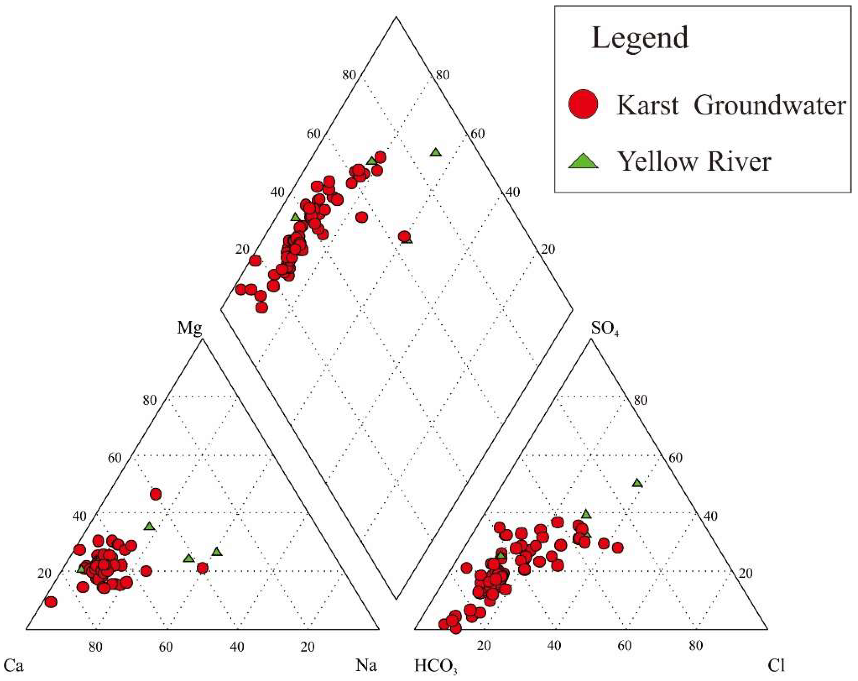
The major cations of karst groundwater samples were Ca2+ and Mg2+ (Figure 2). The order of cations in karst groundwater in terms of concentration was Ca2+ > Mg2+ > Na+ > K+, with Ca2+, Mg2+, and Na+, contributing 66%, 22.9%, and 11% of the total cationic charge (TZ+ = Na+ + K+ + 2Mg2+ + 2Ca2+ in meq/L), respectively. Major anions of karst groundwater were HCO3 and NO3 (Figure 2), and the order of anions in terms of total molar anion concentrations was HCO3 > NO3 > SO42− > Cl, with HCO3, NO3, SO42−, and Cl, contributing 39%, 37%, 13%, and 11% of the total anionic charge (TZ = Cl + 2SO42− + NO3 + HCO3 in meq/L), respectively. The karst groundwater samples were mostly of the Ca·Mg-HCO3·SO4 type.
The major cations of Yellow River water samples were Ca2+ and Na+. The rank of cations in terms of total concentration was: Ca2+ > Na+ > Mg2+ > K+, with Ca2+, Na+, and Mg2+, contributing 40%, 30%, and 28% of total cationic charge, respectively. The major anions of Yellow River water were SO42− and Cl (Figure 3b), and the order of anions in terms of total molar concentrations was SO42− > Cl > NO3 > HCO3, with SO42−, Cl, NO3, and HCO3, contributing 33%, 27%, 20%, and 20% of the total anionic charge, respectively. The Yellow River water samples were of the Ca·Na·Mg-SO4·Cl type.
The chemical composition of groundwater can be altered by the weathering process and aquifer matrix [5]. The Gibbs diagram, displaying TDS vs. (Na + K)/(Na + K + Ca) and Cl/(Cl + HCO3), can effectively determine groundwater geochemistry [29]. In this study, most groundwater samples were spread in the evaporation and rock–water interaction fields (Figure 3). This finding demonstrated that the bulk of the samples was governed by rock dominance processes and evaporation [5], and this result also implies that evaporation and rock dominance processes have significant influences on groundwater quality [5].

4.2. Saturation Indices

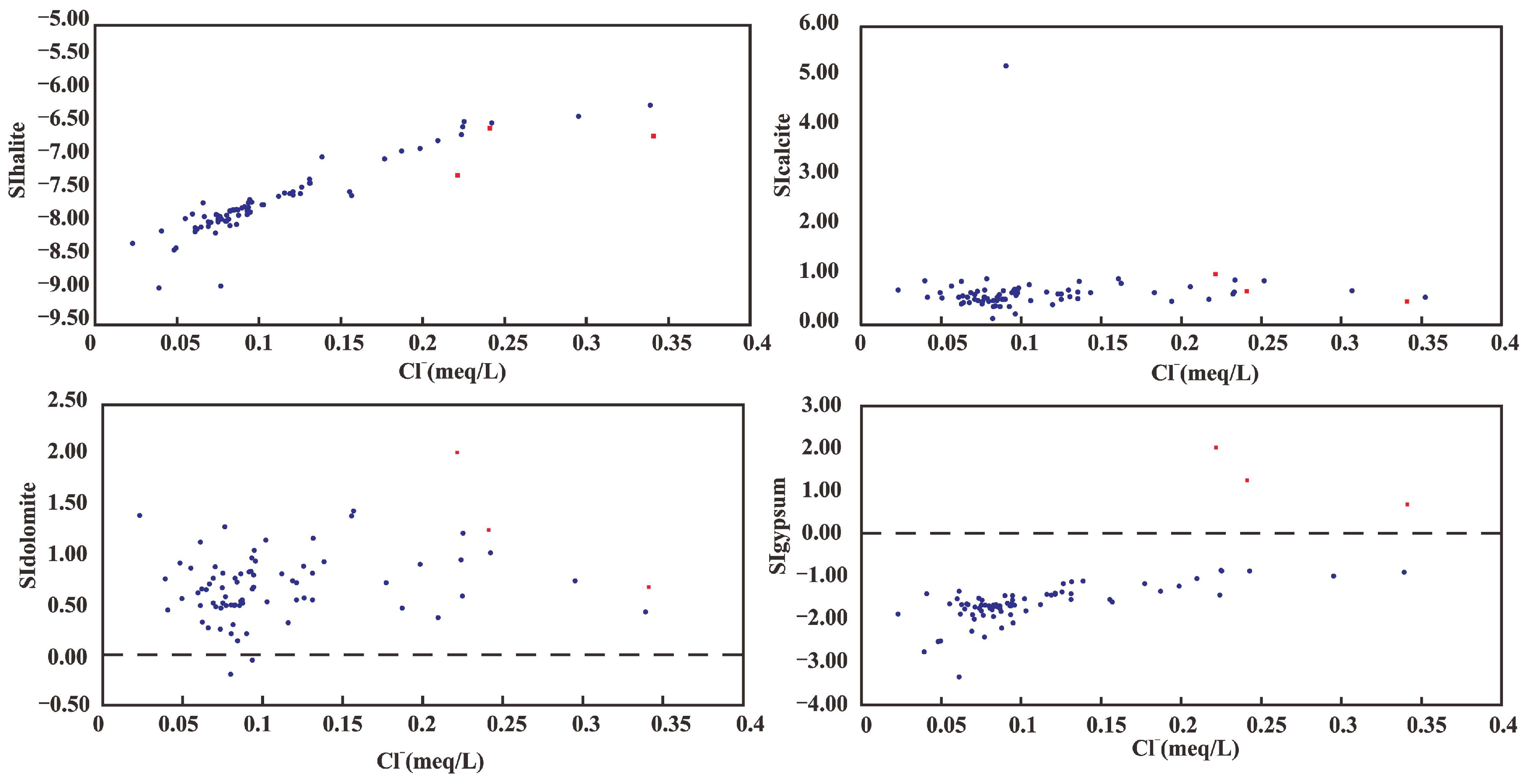
All karst groundwater samples contained calcite and dolomite concentrations at saturation or above, indicating the possibility of calcite and dolomite precipitation. The gypsum concentration in karst groundwater samples did not reach the saturation index (SI), indicating the possibility of gypsum dissolution. The halite concentrations of all karst groundwater samples were below the SI (SIhalite < 0). The Yellow River water showed the same saturation properties as karst groundwater, indicating precipitation of calcite and dolomite and dissolution of gypsum and halite (Figure 4).

4.3. Isotopic Characteristics of Water in the Changqing-Xiaolipu Area

Both the Yellow River water and karst groundwater samples showed similar low variation in stable isotope content (Figure 5), with δ18O ranging from −8.93 to −7.07‰ (mean of −8.2‰) and δD ranging from −64.7 to −52.7 ‰ (mean of −59.8‰) (Table 2). 14C of karst groundwater ranged from 84.2 to 96.7 pMC. δ18O and δD of Yellow River water were −8.83‰ and −64.7‰, respectively, whereas 14C was 90.7 pMC (Table 2).

5. Discussion

5.1. Origin and Recharge of Groundwater

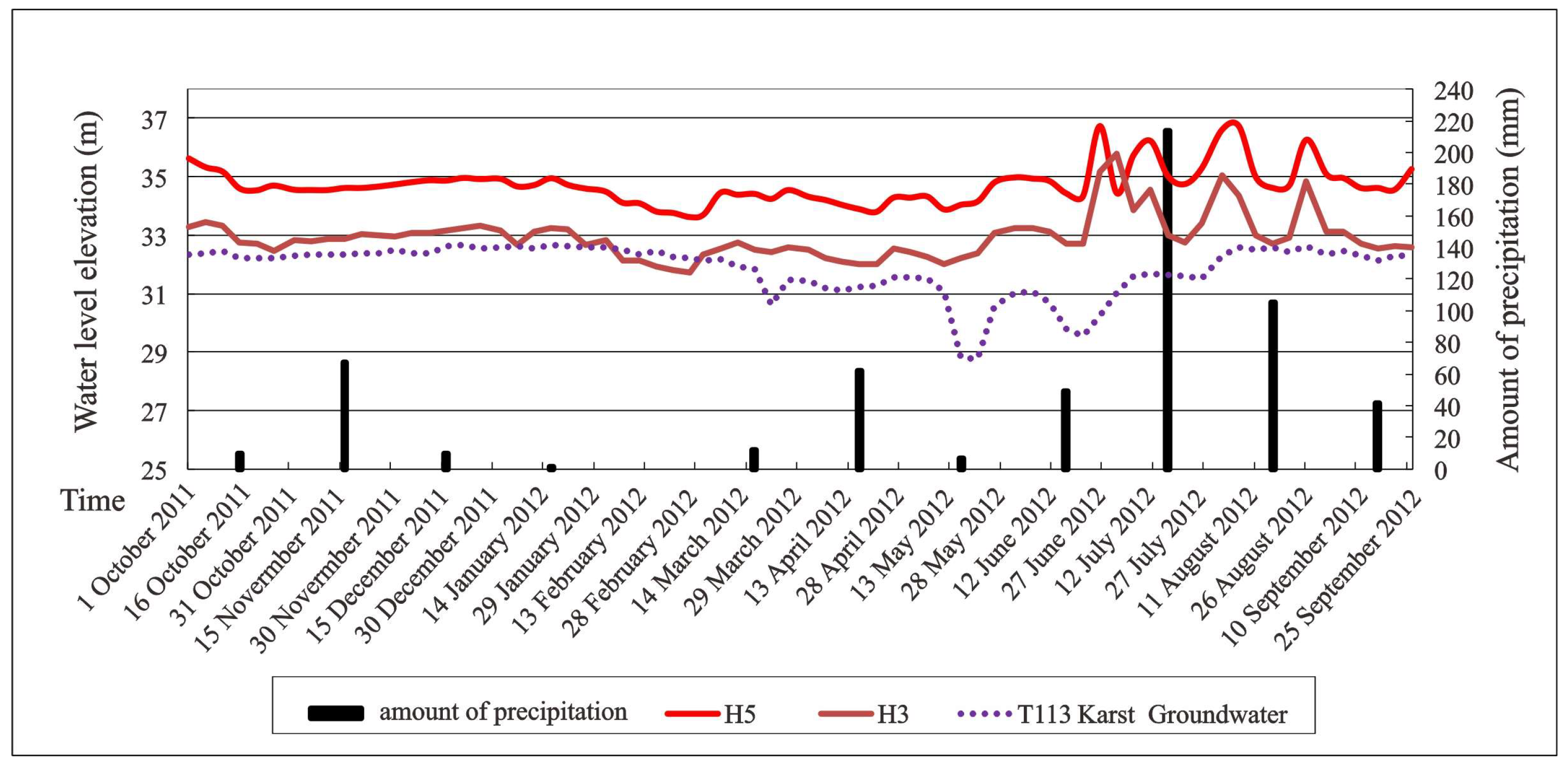
Both δ18O and δD are important indicators of sources of groundwater recharge and can help with understanding the water cycle [33]. δ18O and δD of karst groundwater were distributed far from the LWML and close to those of the Yellow River water and water from the recharge area in the southern mountain region (Figure 5). These results indicated that the groundwater in the recharge area in the southern mountain region is mostly recharged by infiltration of Yellow River water or through infiltration of local rainfall. However, the variations in the karst groundwater table depth were closely related to the depth of the Yellow River table and showed no correlation with rainfall (Figure 6). In addition, 14C of karst groundwater ranged from 84.2 to 96.7 pMC, whereas that of Yellow River water was 90.7 pMC, indicating that the karst groundwater is not old and that there was a minor degree of mixing between the Yellow River water and groundwater before 1390 BP [34]. Therefore, the present study proposes that the karst groundwater is recharged by the groundwater in the southern mountain region and is subsequently modified by mixing with water of the Yellow River.

5.2. Hydrochemical Evidence for Mixing between Yellow River Water and Karst Groundwater and Its Quantification

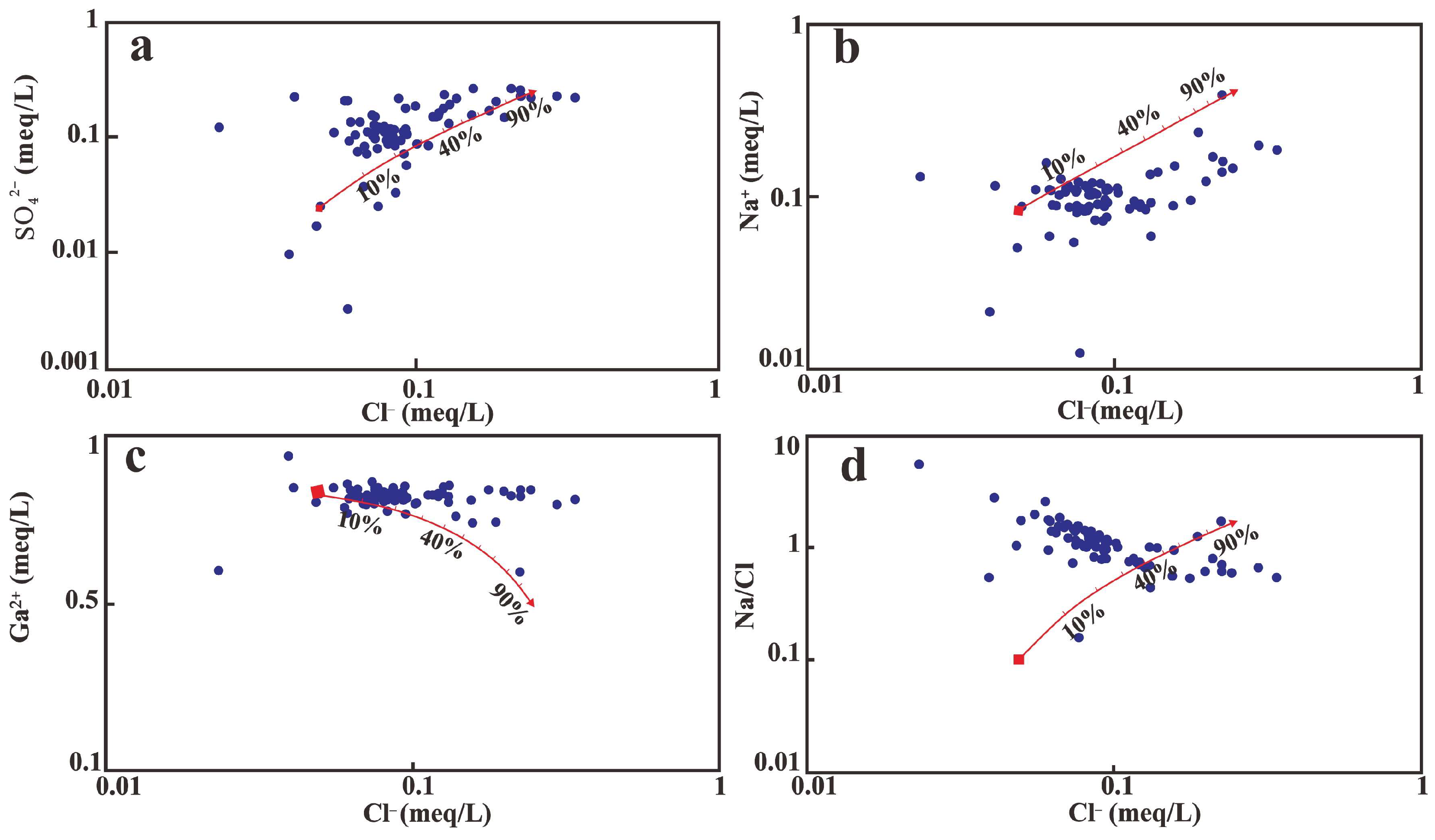
No samples showed halite concentrations at or above saturation, thereby excluding the possibility of halite precipitation under current conditions (Figure 4). Hence, Cl is used to behave relatively conservatively in the mixing model [35]. The relationship between Cl/HCO3 molar ratios and Cl showed a predominantly linear pattern (Figure 7), suggesting mixing between Yellow River water and groundwater in the groundwater recharge area in the southern mountain region. The results show that the mixing of Yellow River water and karst groundwater is one of the processes leading to groundwater salinization. However, deviation of some samples from this line indicated the involvement of other processes. The relationship between the concentrations of SO42− and Cl depicted in Figure 8a suggests that most data points of karst groundwater are near the mixing trend, also indicating the mixing process of these waters. The relationship between Na+ and Cl was indicative of this mixing (Figure 8b). In general, the major ion/Cl ratios increasingly approximated the observed mixing lines as salinity increased (Figure 8), which can be attributed to the total solute load from mixing overwhelming the properties of other processes.
For the most groundwater samples, the Yellow River water mixing proportions were estimated to increase from 10% to 30% of the mixed waters. This mixing pattern is of great significance for evaluating the extent to which the Yellow River recharges the Changqing-Xiaolipu water resource.

5.3. Water Quality Assessment

Water quality assessment and management is one of the most important aspects of water management. This has attained significant global importance over the years in view of growing concerns and awareness of environment- and health-related impacts. Water from the Changqing-Xiaolipu karst aquifer is mainly used for domestic water supply. Over 97% of the karst groundwater samples fell within the TDS and pH domestic water standards prescribed by the Ministry of Health (2006). High domestic water contents of sulfate can result in diarrhea, dehydration, and weight loss in humans, whereas high nitrate concentrations can result in birth defects, hypertension, and high-Fe hemoglobin [36]. The domestic water limits for sulfate and nitrate in China are 250 and 20 mg/L, respectively. Most of the karst groundwater samples exceeded the permissible domestic, industrial, and agricultural water standards for nitrate. This phenomenon may be caused by the nitrate occurring in the reservoir. Therefore, the karst groundwater should be pretreated to reduce the nitrate concentration. In addition, approximately 4% and 84% of the Yellow River samples exceeded the permissible domestic water standards for sulfate and nitrate, respectively, indicating that this water is not suitable for domestic use. The water of the Yellow River is also highly saline, further precluding its suitability for consumption by humans and animals. Thus, groundwater in the southern mountain region is an important freshwater source for human domestic use. Achieving sustainable development of water resources in this area in the future will require further pollution prevention and control.

6. Conclusions

The present study used a combination of hydrodynamic, hydrochemical, and stable isotopic data to identify the role of the Yellow River in recharging the Changqing-Xiaolipu aquifer. This aquifer in the Yellow River Basin, eastern China shows complex groundwater table dynamics. The analytical results of major ions in karst groundwater exhibited the trends of Ca2+ > Mg2+ > Na+ > K+ and HCO3 > NO3 > SO42− > Cl, respectively. These trends showed that the karst groundwater was mostly of the Ca·Mg-HCO3·SO4 type. In addition, the obtained physicochemical parameters in Yellow River water revealed that ionic sequences of Ca2+ > Na+ > Mg2+ > K+ and SO42− > Cl > NO3 > HCO3 associated with the Ca·Na·Mg-SO4·Cl water type. The hydrogeochemical facies of karst groundwater revealed the influence of evaporation and rock–water interaction on the groundwater quality. The data for isotopes (δ18O, δD, and 14C) and major ion/Cl ratios highlighted the beneficial influence of diverted water from the Yellow River to recharging the aquifer system. Although the Yellow River contributes 10–30% of the karst Changqing-Xiaolipu aquifer, this river should be considered when characterizing the chemistry and budget of groundwater. Most of the karst groundwater in this area has good water quality and is suitable for domestic use, but more attention should be paid to the high concentrations of nitrate and sulfide in the aquifer water in the future.

Author Contributions

Conceptualization, D.Y. and J.Y.; methodology, D.W.; software, Y.H.; validation, B.S., L.Z. and H.C.; investigation, D.W.; resources, D.W.; data curation, D.W.; writing—original draft preparation, D.Y.; writing—review and editing, R.L.; funding acquisition, R.L. All authors have read and agreed to the published version of the manuscript.

Funding

This research was funded by the National Natural Science Foundation of China (Grant No. 42102076) and the Shandong Provincial Natural Science Foundation (ZR2021QD037).

Institutional Review Board Statement

Not applicable.

Informed Consent Statement

Not applicable.

Data Availability Statement

Some or all data that support the findings of this study are available from the corresponding author upon reasonable request.

Acknowledgments

We especially thank the anonymous reviewers and Huaizhi Shao in Shandong University of Technology for their valuable and constructive comments.

Conflicts of Interest

The authors declare no conflict of interest.

References

  1. Balek, J. Groundwater recharge concepts. In Estimation of Natural Groundwater Recharge; Springer: Dordrecht, The Netherlands, 1988; pp. 3–9. [Google Scholar]
  2. Lerner, D.N.; Issar, A.S.; Simmers, I. Groundwater Recharge: A Guide to Understanding and Estimating Natural Recharge; IAH International Contributions to Hydrogeology No. 8; Heinz Heise: Hannover, Germany, 1990. [Google Scholar]
  3. Simmers, I.; Hendrickx, J.M.H.; Kruseman, G.P.; Rushton, K.R. Recharge of Phreatic Aquifers in (Semi-)Arid Areas; IAH International Contributions to Hydrogeology 19; Routledge: Oxfordshire, UK, 1997; Volume 49, pp. e34–e35. [Google Scholar]
  4. Han, D.; Liang, X.; Currell, M.J.; Song, X.; Chen, Z.; Jin, M.; Liu, C.; Han, Y. Environmental isotopic and hydrochemical characteristics of groundwater systems in Daying and Qicun geothermal fields, Xinzhou Basin, Shanxi, China. Hydrol. Process. 2010, 24, 3157–3176. [Google Scholar] [CrossRef]
  5. El Osta, M.; Masoud, M.; Alqarawy, A.; Elsayed, S.; Gad, M. Groundwater Suitability for Drinking and Irrigation Using Water Quality Indices and Multivariate Modeling in Makkah Al-Mukarramah Province, Saudi Arabia. Water 2022, 14, 483. [Google Scholar] [CrossRef]
  6. Masoud, M.; El Osta, M.; Alqarawy, A.; Elsayed, S.; Gad, M. Evaluation of groundwater quality for agricultural under different conditions using water quality indices, partial least squares regression models, and GIS approaches. Appl. Water Sci. 2022, 12, 244. [Google Scholar] [CrossRef]
  7. Shakeri, A.; Ghoreyshinia, S.; Mehrabi, B. Surface and groundwater quality in Taftan geothermal field, SE Iran. Water Qual. Expo. Health 2015, 7, 205–218. [Google Scholar] [CrossRef]
  8. Gad, M.; Saad, A. Hydrogeochemical evaluation of fractured Limestone aquifer by applying a geochemical model in eastern Nile Valley, Egypt. Environ. Earth Sci. 2017, 76, 641. [Google Scholar] [CrossRef]
  9. Gad, M.; Dahab, K.; Ibrahim, H. Applying of a geochemical model on the Nubian sandstone aquifer in Siwa Oasis, Western Desert, Egypt. Environ. Earth Sci. 2018, 77, 401. [Google Scholar] [CrossRef]
  10. Gad, M.; El-Hendawy, S.; Al-Suhaibani, N.; Tahir, M.U.; Mubushar, M.; Elsayed, S. Combining hydrogeochemical characterization and a hyperspectral reflectance tool for assessing quality and suitability of two groundwater resources for irrigation in Egypt. Water 2020, 12, 2169. [Google Scholar] [CrossRef]
  11. Hussein, H.A.; Ricka, A.; Kuchovsky, T.; El Osta, M.M. Groundwater hydrochemistry and origin in the south-eastern part of WadiEl Natrun, Egypt. Arab. Geosci. 2017, 10, 170–184. [Google Scholar] [CrossRef]
  12. Egbueri, J.C. Assessment of the quality of groundwaters proximal to dumpsites in Awka and Nnewi metropolises: A comparative approach. Int. J. Energy Water Resour. 2018, 2, 33–48. [Google Scholar] [CrossRef]
  13. Zhang, X.; Hu, B.X.; Wang, P.; Chen, J.; Yang, L.; Xiao, K.; Zhang, X. Hydrogeochemical evolution and heavy metal contamination in groundwater of a reclaimed land on Zhoushan Island. Water 2018, 10, 316. [Google Scholar] [CrossRef]
  14. Mgbenu, C.N.; Egbueri, J.C. The hydrogeochemical signatures, quality indices and health risk assessment of water resources in Umunya district, southeast Nigeria. Appl. Water Sci. 2019, 9, 22. [Google Scholar] [CrossRef] [Green Version]
  15. Kumar, S.K.; Logeshkumaran, A.; Magesh, N.S.; Godson, P.S.; Chandrasekar, N. Hydro-geochemistry and application of water quality index (WQI) for groundwater quality assessment, Anna Nagar, part of Chennai City, Tamil Nadu, India. Appl. Water Sci. 2015, 5, 335–343. [Google Scholar] [CrossRef] [Green Version]
  16. Mirzavand, M.; Sadeghi, S.; Bagheri, R. Groundwater and soil salinization and geochemical evolution of Femenin-Ghahavand plain, Iran. Environ. Sci. Pollut. Res. 2020, 27, 43056–43066. [Google Scholar] [CrossRef]
  17. Yang, S.Y.; Wang, S.; Lian, E.G.; Li, C.; Yang, C.f.; Liu, P.F.; Deng, K. Hydrogen and Oxygen Isotopes in Yangtze River Water and Its Application in Tracing Basin-Scale Water Cycle. J. Tongji Univ. 2021, 49, 1353–1362. [Google Scholar]
  18. Gat, J.R. Oxygen and hydrogen isotopes in the hydrologic cycle. Annu. Rev. Earth Planet. Sci. 1996, 24, 225–262. [Google Scholar] [CrossRef] [Green Version]
  19. Gibson, J.J.; Aggarwal, P.; Hogan, J.; Kendall, C.; Martinelli, L.A.; Stichler, W.; Rank, D.; Goni, I.; Choudhry, M.; Gat, J.; et al. Isotope studies in large river basins: A new global research focus. Eos Trans. Am. Geophys. Union 2002, 83, 613–617. [Google Scholar] [CrossRef]
  20. Xu, J.X.; Xing, L.T.; Tong, G.Y.; Fan, L.Q. Groundwater environment evolution and its conservation in Jinan spring catchment. Eng. Geol. 2004, 31, 69–73. [Google Scholar]
  21. Xing, L.; Lu, M.; Hu, L. Present situation and protection strategies for environmental problems of karst groundwater in Jinan spring region. J. Jinan Univ. Sci. Technol. Ed. 2006, 20, 345. [Google Scholar]
  22. Li, T.X.; Li, L.; Liu, Y.J. Systematic Analysis of Characteristics and Effected Elements of Spring in Jinan City. Land Resour. Shandong Prov. 2003, 19, 48–51. [Google Scholar]
  23. Bo, K.T.; Cai, Y.X. Calculation of Karst Groundwater Resources and Analysis on Exploitation Potentiality of Changqing-Xiaolipu Hydrogeologic Unit. ShangDong Land Resour. 2015, 31, 37–42. [Google Scholar]
  24. Fan, X.M.; Shu, L.C.; Liu, G.H.; Schwanenberg, D.; Ongor, B.T.I. Coupled SOBEK and Visual MODFLOW Model for Yellow River Delta Water Resources Interaction Analysis; Yellow River Conservancy Press: Zhenzhou, China, 2007; pp. 220–226. [Google Scholar]
  25. Lou, G.Y.; Li, R.; Zhang, S.F.; Ge, L.; Fan, X.M. Study on Ground Water Level & Water Balance Influence under Different Water Compensation Schemes of the Yellow River Delta. In Proceedings of the 3rd International Yellow River Forum, Dongying, China, 16–19 October 2007; pp. 303–313. [Google Scholar]
  26. Gonçalves, J.M.; Pereira, L.S.; Fang, S.X.; Dong, B. Modelling and multicriteria analysis of water saving scenarios for an irrigation district in the upper Yellow River Basin. Water 2007, 94, 93–108. [Google Scholar] [CrossRef]
  27. Liu, Q.; Li, F.; Li, J.; Luo, B.; Huang, C. Geochemical and isotopic evidence of shallow groundwater salinization in a reclaimed coastal zone: The Yellow River Delta, China. Environ. Earth Sci. 2016, 75, 1107. [Google Scholar] [CrossRef]
  28. Freeze, R.A.; Cherry, J.A. Ground Water; Preatice-Hall Inc.: Hoboken, NJ, USA, 1979. [Google Scholar]
  29. Gibbs, R.J. Mechanisms controlling world water chemistry. Science 1970, 170, 1088–1090. [Google Scholar] [CrossRef] [PubMed]
  30. Müller, B.; Berg, M.; Pernet-Coudrier, B.; Qi, W.; Liu, H. The geochemistry of the Yangtze River: Seasonality of concentrations and temporal trends of chemical loads. Glob. Biogeochem. Cycles 2012, 26, GB2028-1–GB2028-14. [Google Scholar] [CrossRef]
  31. Li, S.L.; Liu, C.Q.; Li, J.; Liu, X.; Chetelat, B.; Wang, B.; Wang, F. Assessment of the sources of nitrate in the Changjiang River, China using a nitrogen and oxygen isotopic approach. Environ. Sci. Technol. 2010, 44, 1573–1578. [Google Scholar] [CrossRef]
  32. Lambs, L.; Muller, E.; Fromard, F. The Guianese paradox: How can the freshwater outflow from the Amazon increase the salinity of the Guianan shore? J. Hydrol. 2007, 342, 88–96. [Google Scholar] [CrossRef] [Green Version]
  33. Faure, G.; Mensing, T.M. Isotope Principle and Applications, 3rd ed.; John Wiley & Sons: Hoboken, NJ, USA, 2005. [Google Scholar]
  34. Edmunds, W.M.; Smedley, P.L. Residence time indicators in groundwater: The East Midlands Triassic sandstone aquifer. Appl. Geochem. 2000, 15, 737–752. [Google Scholar] [CrossRef]
  35. Eugster, H.P.; Jones, B.F. Behavior of major solutes during closed-basin brine evolution. Science 1979, 279, 609–631. [Google Scholar] [CrossRef]
  36. WHO. Guidelines for Drinking-Water Quality; World Health Organization: Geneva, Switzerland, 2011; Volume 216, p. 303. [Google Scholar]
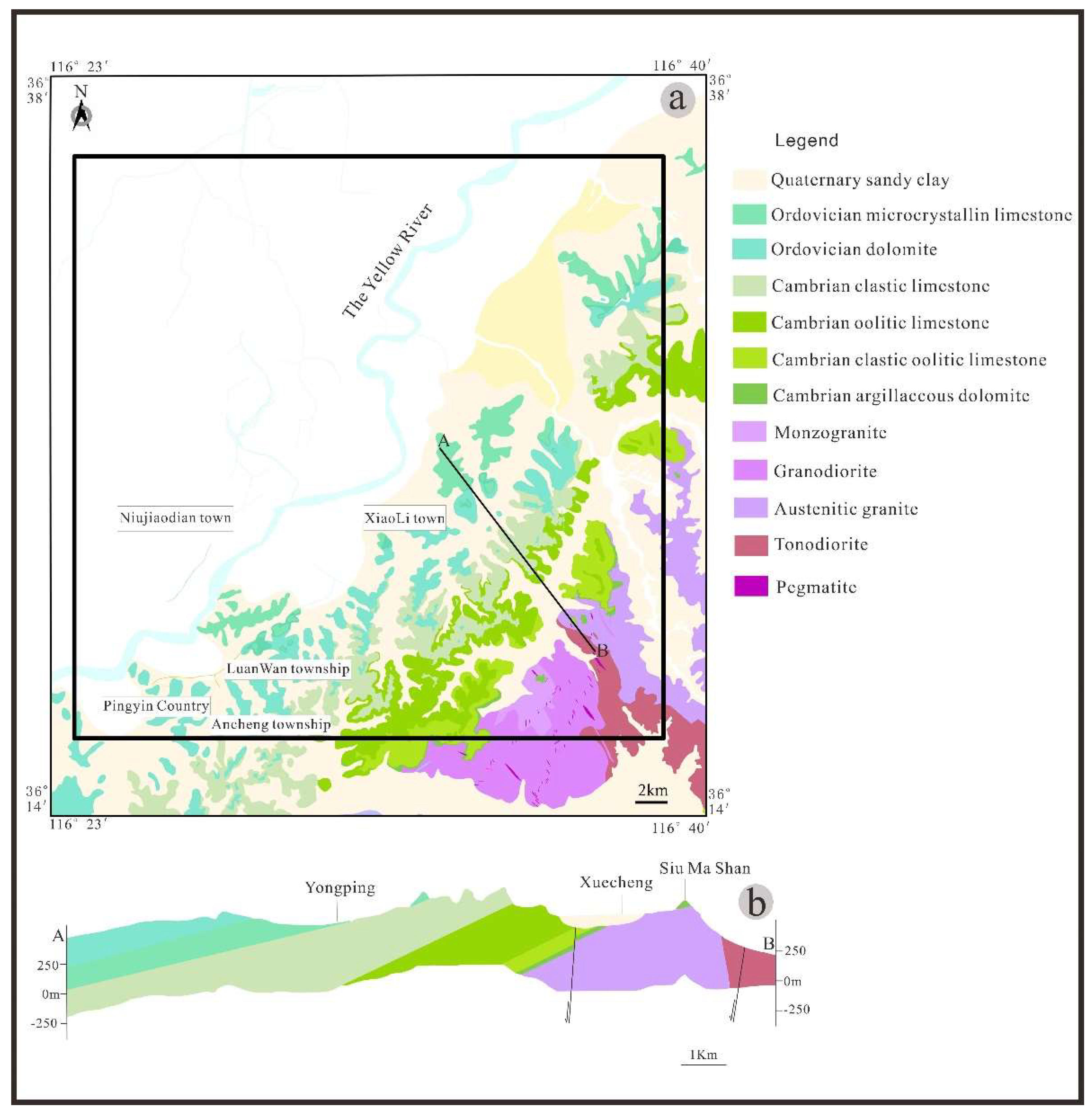
Figure 1. (a) Map showing the geology of the Changqing-Xiaolipu area, southwestern Jinan city, central Shandong Province. The black box encompasses the Changqing-Xiaolipu aquifer. The black line between A and B is the section line. (b) Cross section of the Changqing-Xiaolipu aquifer.
Sustainability 15 02439 g001
Figure 2. Piper plots showing proportions of major ions in karst groundwater and Yellow River water for the Changqing-Xiaolipu area, southwestern Jinan city, central Shandong Province.
Sustainability 15 02439 g002
Figure 3. Karst groundwater facies and their controlling mechanisms along the Changqing-Xiaolipu aquifer.
Sustainability 15 02439 g003
Figure 4. Saturation indices (SI) for halite, calcite, dolomite, and gypsum for the Changqing-Xiaolipu area, southwestern Jinan city, central Shandong Province. All samples were processed using PHREEQC version 2.8 (U.S. Geological Survey, Reston, VA, USA). Note: the blue circle is karst groundwater and the red circle is the Yellow River.
Sustainability 15 02439 g004
Figure 5. δD-δ18O plot of the karst groundwater and the Yellow River water for the Changqing-Xiaolipu area, southwestern Jinan city, central Shandong Province. GMWL, global meteoric water line. The data of the Yangtze River and Amazon River are from [30,31,32].
Sustainability 15 02439 g005
Figure 6. Variations in groundwater table depth and depth of the Yellow River (2011 to 2012) from measurements at typical wells in response to rainfall for the Changqing-Xiaolipu area, southwestern Jinan city, central Shandong Province. Note: H5 and H3 are the two sample sites along the Yellow River.
Sustainability 15 02439 g006
Figure 7. Hydrochemical relationships between the concentrations of Cl and Cl/HCO3 for the Changqing-Xiaolipu area, southwestern Jinan city, central Shandong Province. The line represents mixing between the two endmembers: the Yellow River (red triangle) and groundwater from the groundwater recharge area in the southern mountain region (red square). Numbers along the mixing line show the percentage (%) of the Yellow River at 10% increments under simple mixing behavior. Concentrations are expressed in meq/L.
Sustainability 15 02439 g007
Figure 8. Hydrochemical relationships between the concentrations of Cl and SO42− (a), Na+ (b), Ca2+ (c), and Na+/Cl (d) for the Changqing-Xiaolipu area, southwestern Jinan city, central Shandong Province. The line, two endmembers, and number along the mixing line have the same meanings as those in Figure 7.
Sustainability 15 02439 g008
Table 1. A summary of the hydrochemical properties of karst groundwater and Yellow River water from the Changqing-Xiaolipu area, southwestern Jinan city, central Shandong Province.
GroupWater NumberWater Temperature (℃)pHK+Na+Ca2+Mg2+ClSO42−HCO3NO3TDS (mg/L)
Karst GroundwaterCC6-1167.70.4415.010318.828.557.426861.3569
CC6-2167.60.5014.310019.829.555.225761.4555
CC6-3167.70.5018.610123.633.444.227662.3575
CC6-4167.70.6018.610522.031.961.926864.1588
CC8-1167.70.5615.010122.529.864.126877.1594
CC8-2167.60.5014.399.5322.031.148.627359.0566
CC8-3167.70.5018.697.7223.639.846.427351.6566
CC8-4167.80.5018.610422.533.464.127655.3591
CC11-1167.40.4413.394.220.730.864.026848.6547
CC11-2167.70.5014.395.920.327.959.727949.6527
CC11-3167.70.7018.695.920.927.953.027045.5549
CC11-4167.70.5018.610222.034.253.028149.3577
CC12-1167.60.4410.011820.128.381.825756.5579
CC12-2167.80.4014.392.320.923.953.026743.5531
CC12-3167.80.5017.188.722.029.568.527338.2553
CC12-4167.70.4018.695.020.932.759.727838.5560
CX5-1177.61.6048.023537.932.759.73503681308
CX5-2157.51.3028.617939.167.992.8332223980
CX5-3167.51.6037.123641.71111563553011238
CX7-1157.70.5614.494.418.735.518.231032.7548
CX7-2157.90.7520.011217.022.861.930070.7619
CX7-3157.40.7022.913622.535.855.240653.4750
CX36167.60.9048.016523.612221026544.1893
CX39157.80.6015.778.717.625.542.027110.2476
CX40157.90.5010.067.013.715.911.12565.50395
CX46167.90.7014.375.115.921.544.22559.54451
CX58167.70.5614.467.420.122.81.673044.21453
CX58167.90.7512.071.121.929.242.02555.59448
CX58168.00.6015.771.621.435.729.32788.01475
C7-1157.80.6616.680.518.130.463.92627.99502
C7-2158.00.8816.076.118.224.133.125511.7448
C7-3158.20.7017.180.515.927.939.826812.6478
C7-4157.80.601.5677.818.227.412.227811.1439
C19-1167.91.1124.784.218.221.610222922.8515
C19-2168.10.8019.394.622.538.195.223128.9542
C28-1168.10.6020.053.037.59.5268.33045.06515
C28-2168.01.1112.012822.525.411726383.3664
C29167.72.3220.097.218.2333.010822150.2566
C31167.91.1114.010618.829.279.526143.9566
C230167.70.6322.423543.779.91593572851201
CK1-1157.70.5616.613331.043.160.9334109750
CK1-2157.90.7520.010421.940.661.929538.2595
CK1-3167.70.7020.012328.045.477.332973.5712
CK1-4157.70.3018.612727.354.856.134257.0696
T69167.70.7014.396.817.622.366.324839.2519
T80167.90.6716.093.521.937.239.129116.4531
T85167.80.8820.010615.815.211323845.1566
T94-1167.413.165.028435.71902634031911462
T94-2257.512.675.027138.62012784241941512
T94-3177.612.870.029135.72022523892381491
T96178.10.8020.012830.761.984.0239193.8758
T97167.90.5014.374.218.123.817.92689.43441
T99167.80.447.582.423.820.29.763406.18505
T101177.60.4022.916728.564.5163284128876
T105167.45.4310030443.42752433104001701
T105177.65.0086.723937.32072172922581342
T112167.61.6844.015945.893.219837858.3978
T112V167.70.8953.310924.190.813425712.4682
T112b167.80.7826.811023.259.982.629313.6611
T113178.11.1086.776.024.796.41501948.57652
PT1-1167.60.8520.713229.758.910730366.5718
PT1-2167.70.8019.313127.056.797.029664.8693
PT1-3167.70.8119.812927.556.798.330365.0700
PT1-4167.50.7620.812926.955.798.930663.0701
165167.80.7020.013828.557.111027692.8737
SJ168.00.383.641308.5111.43.8424147.8555
QL1167.80.2015.712822.536.995.2247110.3671
G2-1167.80.6917.995.819.137.661.527729.5553
G2-2167.40.8320.010321.340.164.429629.6593
G2-3167.90.7214.296.418.836.560.027228.2542
G2-4167.60.7218.691.715.832.960.627225.9531
G2-5167.90.9511.395.417.633.561.226925.9527
G2-6167.80.7619.388.216.225.169.826027.9522
G2-7167.80.9116.690.2 16.226.747.225620.6488
XTS258.31.3022.973.3 23.145.410414628.6454
HHS167.70.5018.610220.933.455.227654.1577
Yellow RiverH5178.24.0093.365.231.811415521318.7707
H6268.66.5731.475.133.566.112212454.5531
H11158.53.7170.075.126.311821063.11.29577
Abbreviations: TDS—total dissolved solids.
Table 2. 18O, D and 14C in karst groundwater and Yellow River water for the Changqing-Xiaolipu area, southwestern Jinan city, central Shandong Province.
GroupSample
Number
18O (‰)D (‰)14C (pMC)
Karst GroundwaterCL1−8.41−63.6784.2
CX4−7.07−52.7095.3
G2−8.65−63.04
T84−7.96−58.09
T89−8.57−60.39
T93−8.27−59.85
T105−7.70−56.3596.7
X5−8.93−64.66
Yellow RiverH5−8.83−65.0090.7
Disclaimer/Publisher’s Note: The statements, opinions and data contained in all publications are solely those of the individual author(s) and contributor(s) and not of MDPI and/or the editor(s). MDPI and/or the editor(s) disclaim responsibility for any injury to people or property resulting from any ideas, methods, instructions or products referred to in the content.