Abstract
Site selection for wind farm projects is a vital issue that should be considered in spatial energy planning. This study explores the deployment of onshore wind farms (OWFs) in Greece and assesses their suitability and sustainability using geographic information systems and multicriteria analysis techniques (the analytical hierarchy process—AHP and Technique for Order of Preference by Similarity to Ideal Solution—TOPSIS). Their suitability is assessed in terms of seven exclusion criteria and constraints provided in the Specific Framework for Spatial Planning and Sustainable Development for Renewable Energy Sources (SFSPSD-RES), while their sustainability is assessed in terms of nine environmental, technical-economic, and social assessment criteria in five different scenarios. The obtained results indicated that 81.4% of the existing wind farms are included within suitable areas and the highest percentage of improper siting refers to the installation of wind farms in sites that are within the boundaries of the Natura 2000 protected areas. The existing wind farms located in a part of Peloponnese, at the point bordering the Administrative Region (AR) of Attica, are characterized as more ideal in four out of five of the examined scenarios in the sustainability assessment. The proposed framework of this study is practical and effective in assessing the suitability and sustainability of existing wind farms in a country, and could contribute to spatial energy planning.
1. Introduction
One of the renewable resource technologies with the quickest growth is wind energy [1,2]. It is a quick and relatively easy-to-install sustainable energy source that does not contribute to acid rain or global warming and does not release CO2, CO, or NOx emissions [3]. The issue of wind farm siting has gained great interest the last decades. Many countries have fostered national legislative frameworks and regulations that could aid in accelerating the expansion of wind energy and in the proper siting of wind farms (WFs) on a national and regional scale, considering environmental, economic, technical, and social constraints. The key issue in siting and spatial planning issues regarding renewable energy sources is that there is a gap between theory and practice. Although there are tools to pre-select the optimal siting location for the development of wind energy facilities, in practice they are not used. As a result, wind farm siting planning is often characterized locally and in fragments.
There are numerous studies found in the international literature that aim to identify either suitable or the most suitable sites for wind farm (WF) deployment using geographic information systems (GIS) and multicriteria decision making (MCDM) methods, while considering various exclusion and evaluation criteria (e.g., [3,4,5,6,7,8,9,10,11,12,13,14,15]). It should be noted that the majority of them are implemented on a regional scale (e.g., [5,16,17,18,19,20]) and only a few of them on a national scale [8,11,21]. However, there are a handful of studies that discuss the suitability of existing wind farms based on relative legislative frameworks and policies [15]. Numerous studies have created a framework for site selection without considering or even discussing laws, rules, and policies pertaining to the siting of wind farms or renewable energy sources (RES) in general [22].
The main objective of this study is to develop a reliable framework for assessing existing onshore wind farm (OWF) installations. This study reflects the current situation of onshore wind farms (OWFs) in Greece and evaluates their suitability and sustainability, using geographical information systems and multicriteria analysis techniques (the analytical hierarchy process—AHP and Technique for Order of Preference by Similarity to Ideal Solution—TOPSIS). In order to achieve this, the suitability of the existing WFs is examined in terms of seven (7) exclusion criteria and constraints provided in the national legal framework (Specific Framework for Spatial Planning and Sustainable Development for Renewable Energy Sources (SFSPSD-RES)) [23] and their sustainability is then investigated on the basis of a range of nine (9) environmental, technical-economic, and social assessment criteria. The proposed framework is expected to assist planners in developing and managing a wind energy strategy.
The main contributions and noteworthy aspects of the present study are as follows: (i) numerous economic, technical, environmental, and social criteria are used based on the existing national legal framework and the literature of wind farm siting; (ii) in line with the determined criteria, the compatibility and the sustainability of the existing WFs are examined and assessed using GIS, AHP, and TOPSIS approaches; (iii) to the best of the authors’ knowledge, this is the first study that refers to the suitability and sustainability assessment of existing wind farm deployment at the national level; (iv) this study provides an important background for future planning decisions of WFs’ development; and (v) the proposed approach can be an effective tool for making strategic decisions on the development and planning of Greece’s wind energy potential as well as provide directions for future decisions concerning the land usage of areas occupied with wind farms after their lifecycle.
The rest of the paper is structured as follows: Section 2 describes the two multicriteria methods applied (AHP and TOPSIS) in this study. Section 3 includes a short description of the study area as well as a detailed presentation of the methodological framework for identifying and assessing the existing OWFs at the national scale. Section 4 provides and discusses the main results of the present study, while Section 5 concludes with useful remarks.
2. Multicriteria Decision Making Methods
2.1. Analytical Hierarchy Process (AHP)
The AHP is one of the most frequently used methods in multicriteria decision making (MCDM) and was developed initially by Saaty in 1980 [24] (Saaty, 1980). The AHP method is a pairwise comparison-based multicriteria decision making approach that has been used in many wind farm siting studies (e.g., [4,7,8,9,12,13,14,16,25,26,27]). Weights are derived for decision criteria using pairwise comparisons and a nine-point scale (Saaty fundamental scale) for measuring preferences according to Saaty [24]. The initial step of the AHP method includes the creation of an “nxn” pairwise comparison matrix. The nine-point scale used for these pairwise evaluations is presented in Table 1. The pairwise comparison matrix is normalized by: (a) summing the values in each column; (b) dividing each element in the matrix by the sum of its column; and (c) averaging the values in each row. These average values represent the priority vector or else the relative weights (w) of the assessment criteria.

Table 1.
The nine-point scale [24].
The AHP provides the possibility to specify whether judgments for each criterion are compatible with one another by computing the consistency index () and the consistency ratio () through Equations (1) and (2), respectively, as follows [28]:
where λmax is the maximal eigenvalue and its value corresponds to the sum of the elements of the column of each criterion of the initial matrix with the corresponding priority vector; and the value is the number of assessment criteria.
where depends on the size of the matrix and is called a random consistency index (Table 2) [29].
Table 2.
Random index () values [29].
A rating of 10% or less ( ≤ 10%) is generally considered acceptable and reliable. Whenever the is greater than 10%, the pairwise comparisons are repeated with various judgments until a suitable result is obtained for the consistency check.
2.2. Technique for Order Preference by Similarity to Ideal Solution (TOPSIS)
The TOPSIS method (Technique for Order Preference by Similarity to Ideal Solution) was developed by Hwang Ching-Lai and Yoon in 1981 [30] and is based on the fact that the selected alternative must be as close as possible to the positive ideal solution and as far away as possible from the negative ideal solution.
Several researchers have applied a combination of various MCDM and TOPSIS methods to prioritize renewable energy alternatives (e.g., [31,32,33,34,35]).
The method considers the following six steps, after the definition of the initial assessment matrix, which consists of “” alternatives and “” criteria. Each alternative’s intersection with each criterion is denoted by :
Step 1: Normalize the initial assessment matrix.
Each element of the initial assessment matrix is normalized using Equation (3), where is the number of alternatives, and is the number of criteria:
Step 2: Calculate the weighted normalized decision matrix.
The weighted normalized decision matrix is created by multiplying the weights of each criterion by the weights of the normalized values of the alternatives, using Equation (4), where is the weight of the j-th assessment criterion.
Step 3: Determine the positive and the negative ( ideal solutions using Equations (5) and (6), respectively [36].
where is for the benefit criteria, while is for the non-benefit criteria.
Step 4: Calculate the Euclidean distance of the alternatives from the positive and the negative ideal solutions, using Equations (7) and (8) as follows:
Step 5: Calculate the relative closeness () of each alternative to the positive ideal and the negative ideal solution using Equation (9), and thus identify the ranking order of the alternatives.
Step 6: Rank the alternatives based on the preference order. The alternative with the highest value of is the most preferable solution.
3. Materials and Methods
3.1. Study Area
Greece is geographically a rather privileged country as it constitutes the main linking crossroad between Europe, Asia, and Africa. It consists of 13 geographic regions occupying an estimated surface area of 132 thousand km2. Being on the southeastern edge of Europe, it is almost surrounded by the Mediterranean, specifically by the Aegean, the Ionian, and the Libyan Seas, thus having a coastline of approximately 150,000 km [37]. Crete and Evia are its two biggest islands followed by its basic island groups of the Cyclades, the Sporades, the Dodecanese, the Ionian Islands, the East Aegean Islands, and the Saronikos Islands. Greece also possesses a significant number of uninhabited rocky islands, most of which have been declared as nature reserves as they host endemic birds as well as flora and fauna of exceptional beauty. Others present investment interest, as they meet the required standards and are suitable for the installation of renewable energy sources. All the above, in conjunction with the excellent and rich wind power potential of the country, indicate Greece’s ideal conditions and potential for the dynamic deployment of wind farms (both offshore and onshore). The total wind capacity to the grid (MW) for the year 2021 reached 4451 MW [38].
The social, demographic, cultural, and environmental profile of Greece stands as follows. According to the recent population census of ELSTAT [39], the population of the country comes up to 10,432,481 inhabitants, with the majority, 36%, residing in the region of Attica. There are 13,548 settlements recorded in the country [40]. There are also 924 traditional settlements, mainly small ones (less than 500 inhabitants) but with significant architectural characteristics which constitute part of the newer cultural heritage of the country and are protected cultural areas by law [41]. In accordance with the archaeological cadaster [42], there are currently 17,000 monuments, 3100 archaeological sites, 420 historical sites, 844 protected zones, and 220 museums, some of which are acknowledged and listed as global heritage sites by UNESCO. Regarding protected areas, Greece belongs to the European Network of Protection Zones and Nature Conservation “Natura 2000”. Specifically, 202 Special Protected Areas (SPA) have been recognized nationwide alongside 241 Sites of Community Importance (SCI) [43]. It should be noted that the areas SPA and SCI present overlaps in their acreages. In addition, the country hosts 581 beaches and 15 marinas have been awarded “Blue Flags” for their high quality of seawater [44].
3.2. Methodological Framework for Identifying and Assessing Existing OWFs in Greece
The methodological framework developed and applied in this study is shown in Figure 1. The framework includes three distinct stages.
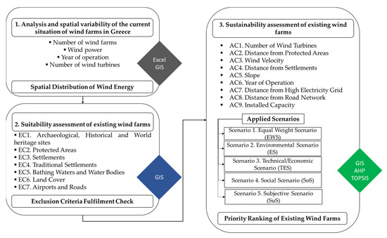
Figure 1.
Methodological framework for suitability and sustainability assessment of existing wind farms in Greece.
The first stage aims to spatially analyze the details and spread of the existing wind farms in the country, which include the number of wind farms, the wind power, the year of operation, and the number of wind turbines. Data are retrieved from [38] and are elaborated with the use of geographic information systems (GIS) and Microsoft Excel.
The second stage entails the suitability assessment of the existing wind farms. A GIS database is created that generates individual thematic maps indicating a set of seven exclusion criteria. The exclusion criteria are those that have an impact on the study area because they make it impossible for a wind farm to be deployed in a particular location due to forecasted environmental zones, uses that are incompatible with other forms of economic activity, or protection rules. The exclusion criteria in this study are mainly retrieved from the SFSPSD-RES [23] and are related to environmental as well as technological and social constraints. Unsuitable zones are found by superimposing the aforementioned maps, and the percentage of the existing wind farms that fail to satisfy the above restrictions is calculated.
In the third stage of the framework, AHP and TOPSIS are applied to assess the sustainability of the existing wind farms and determine their preference order. The multicriteria problem is formulated in three levels as follows: the goal (sustainability assessment of existing wind farms), nine assessment criteria, and the existing wind farms. There are many competing criteria for various aspects, including environmental preservation, economic viability, technical limitations, and even public acceptability of the project. To determine sustainable siting, these parameters must be taken into consideration. The assessment criteria considered in this study are selected from the international literature and are related to technical-economic, environmental, and social factors. The decision problem subsequently lies in selecting the most sustainable sites that best contribute to the success of the objectives, which in our study are as follows: environmental protection, social acceptability, and economic prosperity.
The AHP is employed in the second level and five different scenarios are applied, while the TOPSIS method is performed in the third level. TOPSIS method is used as the number of alternatives (existing wind farms) are quite large and the computation process of this process is not complex; the results are obtained easily and can even be programmed into a simple Excel spreadsheet. Another significant advantage of the selected method is that the optimal solution is not only closer to the ideal solution but is also more distant from the ideal negative solution. It should be noted that the GIS database is also used to create thematic maps depicting the assessment criteria, and these maps are used to support the TOPSIS method implementation.
Details about the exclusion and assessment criteria, their data sources, as well as the quantification of the assessment criteria’s relative weights employed in the AHP for the five different scenarios are provided in Section 3.3 and Section 3.4, respectively.
3.3. Criteria Used in Wind Farm Siting Suitability and Sustainability Assessment
A variety of exclusion and assessment criteria should be considered when determining whether sites are acceptable for wind farms, which is a crucial step in the spatial planning process. In our study, seven exclusion and nine assessment criteria were included in the suitability and sustainability assessment of existing WFs in Greece. Table 3 and Table 4 present the exclusion and assessment criteria, respectively, while their explanations are summarized in the following sub-sections.
Table 3.
Identification of exclusion criteria.
Table 4.
Identification of assessment criteria.
- Archaeological, Historical and World Heritage Sites
Greece is a country with intriguing cultural and historical heritage. Consequently, a lot of sites with monuments of archaeological and historical significance are situated there. Wind farms should be located at a minimum distance of 500 m from any archaeological or historical site. In cases of properties enlisted as World Heritage sites by UNESCO, the minimum distance of WF siting is set at 3000 m in order to preserve the aesthetic value of the cultural environment and avoid visual distortion and reflections. In the international literature there are a lot of scientists who have classified the archaeological and historical places of high importance and cultural monuments (e.g., [16,17,18,19,25]).
- Protected Areas
Wind farms should not be located inside protected areas, as it is crucial to preserve and protect the natural environment. Many researchers have considered various types of protected areas as exclusion criteria in their analyses (e.g., [16,17,18,54,55,56]). The Natura 2000 sites (SPA, SCI, SPA&SCI) considered in this study are excluded from WF siting in order to limit environmental damage and diminish negative impacts, especially for the avifauna.
- Settlements
The SFSPSD-RES determines which settlements are excluded from WF siting. Settlements with equal to or more than 2000 inhabitants should be kept at a minimum distance of 1000 m away from WF installations. WF siting is excluded for a buffer zone of 500 m away from settlements with a population of less than 2000 inhabitants. The distance from settlements is essential to reduce social impacts, such as visual and acoustic disturbances of wind farms, as well as for safety reasons (e.g., [9,11,16,17,18,57]).
- Traditional Settlements
According to the SFSPSD-RES, there should be a distance of 1500 m between a WF and any traditional settlement. This measure is necessary for the protection and preservation of the cultural environment, as well as for the elimination of visual, acoustic, and aesthetic impacts. Many researchers refer to the minimum distance of WFs from traditional settlements (e.g., [16,17,18,58]).
- Bathing Waters and Water Bodies
Rivers and lakes generally referred to as surface water bodies, are excluded from WF siting, as these places constitute natural reserves and host numerous kinds of flora and fauna. It is crucially important to preserve the biodiversity and protect these areas with a buffer distance from onshore wind farm installations (e.g., [9,11,19]).
- Land Cover
Both environmental and economic factors determine a set of constraints based on land restrictions. Using the database of Corine Land Cover (2018) and aiming to avoid land conflicts, the following CLC classes are excluded from WF siting:
- Urban fabric—residential areas (classes 111 and 112)
- Transport units (classes 122, 123 and 124)
- Mines, dump and construction sites (classes 131, 132 and 133)
- Permanently irrigated agricultural land (class 212).
In the international literature, there are numerous researchers who have considered land usage during the process of site selection for wind farm projects (e.g., [11,16,17,18,25,59]).
- Airports and Roads
For safety reasons, wind farm installations should be located at a minimum distance from airports and road networks. In addition, it is possible that wind turbines have negative impacts on operating aircraft by interfering with aviation radar signals. A buffer distance around airports and road networks is very common in similar studies (e.g., [9,11,17,18,19,56,57]).
- Wind Velocity
Wind velocity (m/s) is an assessment criterion which intends to choose the most favorable and suitable territories with the highest average wind speeds. The mean wind speed is a measure which indicates wind resources. High wind velocity could play a significant role in the optimization of the facility. Many researchers have considered wind velocity in their studies (e.g., [11,16,17,18,19,25,57,59]).
- Distance from High-Electricity Grid
Wind farms should be located at the minimum possible distance from national electricity grids and power stations, in order to reduce the initial costs and electricity losses. In the international literature, the distance from high-electricity grids is a very common assessment criterion (e.g., [5,18,25,54,55,56,60]). The closer the site of a WF installation to the electrical grid is situated, the more ideal the location is considered in terms of the efficiency of the facility.
- Slope
Slope (%) could be a restrictive factor in a WF siting, as the higher the land inclination of a place is, the less suitable it is for WF siting. Steep slopes increase the costs dramatically and make the accessibility for installation and maintenance of wind turbines difficult. Flat land spots constitute a more favorable choice for wind farm installations. (e.g., [9,11,16,17,18,25,57,61,62]).
- Distance from Road Network
One of the most important criteria for WF deployment is the distance from the road network. Wind farm installations should be located at the minimum possible distance from road networks. The closer a WF project is to the road network, the less construction and maintenance costs it has. Many studies in the international literature have included the aforementioned assessment criterion (e.g., [5,9,11,16,17,18,25,54,55,57,60]).
- Installed Capacity
The installed capacity (MW) provides useful information about the contribution of wind farms’ and renewable energy sources’ installation output to the total energy balance. The greater installed capacity a WF installation has, the more “green” energy is produced. In the international literature, there are a few case studies that have considered installed capacity as an assessment criterion (e.g., [55,59]).
- Distance from Protected Areas
The adequate distance of WF projects from protected areas guarantees the preservation of the natural environment and ensures the protection of biodiversity, especially avifauna. WF projects should be deployed as far as possible from protected areas to reduce potential negative impacts on the environment. Many researchers use this criterion as an exclusion or/and assessment criterion and recommend various values as a minimum distance (buffer zone) aiming to respect environmental constraints (e.g., [9,11,16,17,18,25,54,55,60,62,63]).
- Year of Operation
The year of wind farm operation is selected as an environmental criterion as it provides useful information for wind farm installation (e.g., [53,55]). Firstly, the more recent the year of operation is, the higher the possibility is of including recent advances and technological trends for wind turbines. At the same time, wind farms with a short operation life cycle present increased capability of contributing to the energy mix for at least the next 20 years (life cycle of the project) and therefore promote sustainable development. In addition, this assessment criterion could identify projects that are at the end of their lifetime and therefore their sites should be reassessed for future wind farm installations. To the authors’ knowledge, this is the first time that this criterion has been used in a wind farm siting decision making process.
- Number of Wind Turbines
The number of wind turbines in a WF installation presents information about the wind capacity and installation costs of the project. In the present research, it is used as an environmental assessment criterion (e.g., [55,57,59]). The increased number of WTs could potentially intensify visual disturbances and reflections. WF projects with a decreased number of turbines (groups of one to five turbines) are considered most suitable.
- Distance from Settlements
The close distance between WFs and settlements amplifies social implications such as visual and acoustic disturbances and causes social reactions, such as the “not in my backyard” (NIMBY) phenomenon. The longer the distance of a settlement from a wind farm installation is, the more favorable and optimal the site is considered to be (e.g., [7,9,11,16,17,18,19,25,57,62]).
3.4. Quantification of Assessment Criteria’s Relative Weights under Different Scenarios
After defining the assessment criteria, a pairwise comparison of these criteria is required to quantify their relative weights with respect to the overall goal, as described in Section 2.1. The pairwise comparisons are performed using the Saaty’s scale. Five different scenarios are deployed, namely: S1. Equal Weight Scenario (EWS), S2. Environmental Scenario (ES), S3. Technical/Economic Scenario (TES), S4. Social Scenario (SoS), and S5. Subjective Scenario (SuS), to check the sensitivity in the priority ranking of the existing wind farms with respect to all the assessment criteria below the goal. Appropriate scenarios have been formulated to cover the three aspects of sustainable development. In EWS, all criteria receive the same weight, while in ES, TES, and SoS, the environmental, the technical/economic, and the social criteria are considered more important, respectively. Finally, in the SuS, the importance of the criteria is based on authors’ judgment and opinion.
Table 5 presents the 9 × 9 pairwise comparison matrix of the nine assessment criteria considered in the present paper under the Subjective Scenario (SuS). The values of the elements of this matrix have been defined based on the authors’ expertise and experience (e.g., [18,64,65,66,67,68]) and with the use of Saaty’s scale. It should be noted that the computation of CR (Equation (2)), which is equivalent to 0.01 and is lower than the threshold of 0.1, is used to confirm the consistency of the 9 × 9 pairwise comparison matrix.
Table 5.
Pairwise comparison for assessment criteria based on SuS.
The relative weights of the evaluation criteria under all the performed scenarios are presented in Figure 2, using the computations described in Section 2.1.
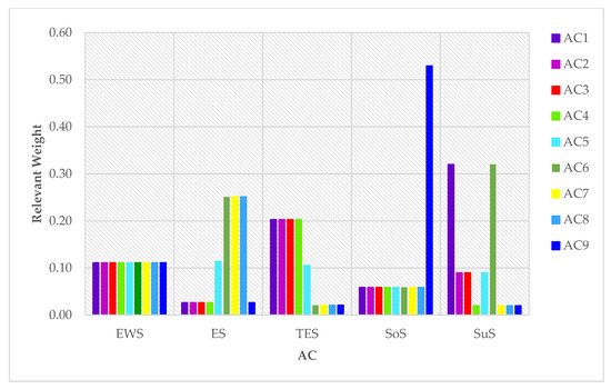
Figure 2.
Relevant weights of assessment criteria under the performed scenarios.
From Figure 2, it can be seen that the relative weights of assessment criteria strongly depend on the scenario performed. For example, in the alternative scenario TES, the criteria with technical-economic aspects, i.e., criteria that are related to functionality, energy efficiency, and minimization of the financial costs of the wind installation, such as Wind Velocity (AC1), Distance from High Electricity Grid (AC2), Slope (AC3), and Distance from Road Network (AC4), present the most important assessment criteria for determining the sustainability of the existing wind farms. In addition, a high weight is attributed to Installed Capacity (AC5), as it is an assessment criterion with a partially financial nature, which guarantees the shortest payback period of the project.
4. Results and Discussion
The outcomes of the current investigation are provided and discussed in the next subsection. First, a spatial analysis and the variability of the existing wind farms of the country are provided (Stage 1 of the proposed methodological framework, Figure 1). Next, the suitability assessment of the existing wind farms is presented (Stage 2 of the proposed methodological framework, Figure 1). Finally, the priority ranking of the existing wind farms in Greece is then established using the findings of the AHP and TOPSIS (Stage 3 of the suggested methodological framework, Figure 1).
4.1. Spatial Variability Analysis of Existing Wind Farms
The generated power in Greece amounted to 4451 MW at the end of 2021 [53], while for the same year, a total of 374 existing wind farms were recorded, distributed throughout the thirteen (13) administrative regions (ARs) of the country, which consist of a minimum of one wind turbine up to a maximum of forty-one (41) wind turbines.
According to Figure 3, the majority of wind farms are concentrated in the administrative region (AR) of Central Greece (37.3%). Additionally, a significant number of wind farms are located in the AR of Crete (11.3%), Peloponnese (10.3%), and Eastern Macedonia and Thrace (10.3%). The lowest numbers of wind farms (less than five) are found in the ARs of Thessaly (0.8%) and Epirus (1.3%). Regarding the energy produced, the AR of Central Greece has by far the largest wind potential (41.3%). Then, the ARs of Peloponnese and Eastern Macedonia and Thrace are next, with the percentages of generated wind power being 13.9% and 11.3%, respectively. It is noteworthy that the AR of Western Greece, although it is not first in the national ranking regarding the number of wind farms in Greece, it comes fourth (8.3%) in terms of the energy produced per region. On the contrary, the AR of Crete contributes to the production of only 4.6% of the total wind power of the country, even though it is second in terms of the number of wind farms. The contribution of the ARs of Western Macedonia (4.5%) and Attica (4.1%) are also very low.
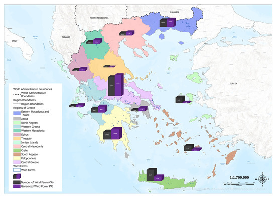
Figure 3.
Number of wind farms (%) and generated wind power (%) per AR of Greece.
Figure 4 shows the evolution over time of the existing wind farm installations in Greece; the data are retrieved from Hellenic Wind Energy Association [38]. Although the rate of the year of operation of new wind farm facilities fluctuates, the majority of the existing wind facilities have a year of operation in the period 2019–2021 (32.4%).
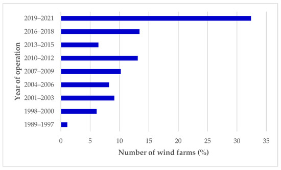
Figure 4.
Year of operation of existing wind farms.
Regarding the number of wind turbines in the existing wind farms, almost half of them (48.7%) consist of one (1) to a maximum of five (5) wind turbines, which is likely due to economic, spatial, and social reasons. The number of wind farms with twenty-one (21) wind turbines or more is quite small, as only 4% of the existing wind farms consist of 21 to 25 wind turbines and only 1.6% of them exceed the number of twenty-six (26) wind turbines.
4.2. Suitability Analysis
Thematic maps related to exclusion criteria of SFSPSD-RES (Table 3) are superimposed to determine the areas that are not appropriate for the deployment of wind farms. The corresponding results are illustrated in Figure 5. The exclusion areas for wind farm deployment are marked in gray, the suitable areas in white, and the existing wind farm installations in red.
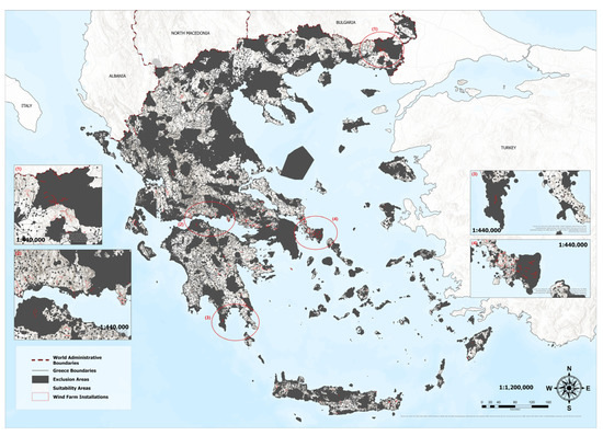
Figure 5.
Unsuitable areas for wind farm siting and existing wind farm installations in Greece.
Examining the results of Figure 5, by superimposing the existing wind farms with the exclusion areas, it can be seen that only 66.4% of the existing wind farms are included within suitable areas (proper siting), while the remaining 33.6% of the existing wind farms are located (either in part or wholly) within the exclusion areas (improper siting). It should be noted that from this percentage, 36% of them had started their operation before the national legal framework (SFSPSD-RES) came into force. Therefore, the percentage of improper siting finally decreases to 18.6%. Table 6 lists the percentage distribution of improper siting based on the respective exclusion criteria.
Table 6.
Percentage of improper wind farm siting due to exclusion criteria.
The highest percentage of improper siting (27.19%) is due to the installation of wind farms in places that are within the boundaries of the “Natura 2000” protected areas. Most of these areas (67%) are characterized as Special Protection Areas (SPA). However, it should be noted that a significant part of these projects may be properly placed if: (i) an environmental impact assessment (EIA) study and (ii) a specific ecological assessment (SpEA) study accompany the deployment of the project.
In addition, 7.68% of the existing wind farms are either adjacent to settlements with less than 2000 inhabitants or within a buffer zone of 500 m from them. The aforementioned siting may amplify social reactions and the NIMBY phenomenon on the one hand, but on the other may contribute to familiarizing residents with the image of wind farms in the landscape. Regarding land cover, 1.32% refers to the improper siting of wind farms within a section of permanently irrigated land, but also within areas where quarrying, mining, and extractive activities are developed.
4.3. Sustainability Analysis
The 374 existing wind farms are assessed and ranked using the AHP and TOPSIS methods in order to determine the sustainability order for the existing wind farms in Greece. Following the process described in Section 2.2, the existing wind farms are ranked based on the relative closeness () of each alternative to the positive and negative ideal solutions.
It should be noted that the values of the initial assessment matrix have been provided using the GIS thematic maps, which are related to the assessment criteria. The nearest distance (minimum in meters) from the high electricity grid, the road network, the protected areas, and the settlements is calculated. The wind velocity of each wind farm installation results from the average values that appear within the wind polygon, while, correspondingly, the slope at the specific location of the installation takes the dominant value. Data on the installed capacity, the year of operation, and the number of wind turbines are retrieved from [53].
The weights of each assessment criterion in the five different scenarios (Figure 2) have been used for the calculation of the weighted normalized decision matrices.
Table 7 presents the positive and negative ideal solutions in the five different scenarios using the computations described in Section 2.2., while Figure 6a–e presents the most sustainable wind farms in Greece for Scenario 1–Scenario 5, respectively.
Table 7.
Positive and negative ideal solutions under scenarios (S1–S5).
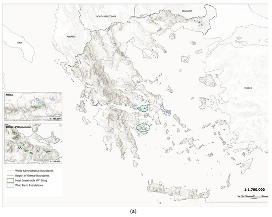
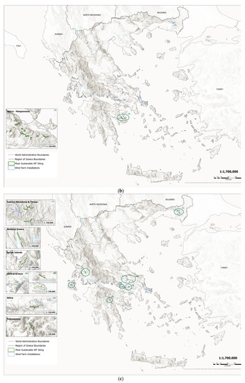
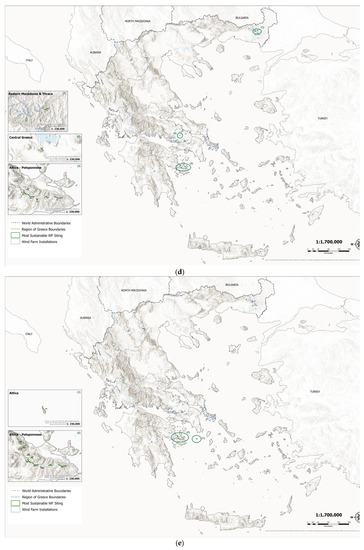
Figure 6.
(a) Scenario1: Equal Weight Scenario (EWS). (b) Scenario 2: Environmental Scenario (ES). (c) Scenario 3: Technical/Economic Scenario (TES). (d) Scenario 4: Social Scenario (SoS). (e) Scenario 5: Subjective Scenario (SuS).
Regarding the Equal Weight Scenario (EWS), wind farms located in the AR of Peloponnese and Attica present the most sustainable wind farm siting (Figure 6a). This is attributed to the fact that these areas present the most favorable conditions, i.e., a relatively high wind velocity at the siting location, relative proximity to the electricity grid and road network, relatively far distance from protected areas and settlements, relatively low slope, relatively recent year of operation, high installment capacity, and few wind turbines.
With regard to the Environmental Scenario (ES), wind farms with an ideal siting are those that are far away from protected areas, have recently started their life cycle, are equipped with wind turbines with new technology (higher energy production), and respect the aesthetics of the landscape. The ten wind farms that meet the above assumptions are concentrated in that part of the Peloponnese that falls within the boundaries of the AR of Peloponnese and Attica (Figure 6b).
Continuing with the Technical/Economic Scenario (TES), the most ideal wind farms are characterized as those located in sites with high wind velocity, at a fairly close distance from the high electricity grid and the road network, in sites with a low slope, and present a high installment capacity. Figure 6c depicts the ten ideal existing wind farms that are spread in almost 50% of the AR of the country (Central Greece, Eastern Macedonia, and Thrace, Peloponnese, Attica, Ionian Islands, and Western Greece).
The Social Scenario (SoS) concerns a more social approach, aiming at the reduction in land conflicts (wind farm–settlement), social reactions, and tensions in local communities. The appearance of the “not in my backyard” (NIMBY) phenomenon is common in cases in which the question of wind farm siting arises [69,70] and specific wind energy projects encounter local opposition. Although people support wind energy, individual wind farms can have undesirable characteristics, such as visual and noise effects. Ideal areas for wind farm siting are considered those that are far enough from settlements (e.g., 8 km, 7.5 km, 6 km, 3 km), and at the same time present satisfactory values in the other assessment criteria (usually not having positive or negative extremes). The aforementioned wind farms are mainly sited in the AR of Eastern Macedonia and Thrace, Central Greece, Peloponnese, and Attica (Figure 6d).
With regard to the Subjective Scenario (SuS), the 10 most sustainable wind farms can be found in part of the Peloponnese, within the borders of the AR of Peloponnese and Attica, as well as on the rocky island of Agios Georgios (Figure 6e). These areas are characterized by satisfactory wind velocity (e.g., 6–7 m/s), low slope, considerable distance from protected areas (about 40 km), and high values of installment capacity (11 MW, 16 MW, 73 MW, etc.).
5. Conclusions
In the present paper, a methodological framework for a spatial analysis as well as a suitability and sustainability assessment of the existing wind farms in Greece has been developed and presented. The main conclusions of this investigation are provided below:
- Exclusion criteria are provided considering the national legal framework (SFSDSP), while the framework of the assessment criteria is created considering the literature review and data availability.
- The country’s existing wind farms are scattered throughout its territory; however, the regions of Central Greece, Peloponnese, Eastern Macedonia and Thrace, and Western Greece play a dominant role in the total installment capacity.
- Most existing wind farms include a relatively small number of wind turbines (up to 10).
- A total of 66.4% of the existing wind farms are included within the eligibility areas according to the institutional framework (SFSDSP) and this percentage increases further (81.4%) if the year of operation is considered.
- Although the weights of the assessment criteria and therefore the siting assumptions differ in the five examined scenarios, overlaps are observed in the results of the ideal solutions.
- The existing wind farms located in a part of Peloponnese, at the point bordering the AR of Attica (241,243,244,246,247,248,249,250,251), are characterized as more ideal in four out of the five examined scenarios in the sustainability assessment (EWS, ES, SoS, and SuS).
Wind farm siting is a complex issue, for which it is necessary to implement a methodological framework with a multicriteria dimension, which should ensure the most efficient operation of the project, the limitation of land conflicts, the full harmonization of the project with the natural environment, and the elimination of negative impacts on the natural and social environment.
The advantages of this work are that it includes numerous economic, technical, environmental, and social criteria according to the current national legal framework and the literature on wind farm siting as well as reliable and efficient methods and techniques, such as the GIS, AHP, and TOPSIS approaches. To the best the authors’ knowledge, this is the first study that discusses the countrywide deployment of existing wind farms and their suitability and sustainability. The proposed approach can be a useful tool for making strategic decisions on the development and planning of Greece’s wind energy potential and can also provide guidelines for future decisions regarding the land usage of areas occupied with wind farms after their lifecycle. The framework adopted in this study will not only serve as an important backdrop for the review of the current planning decisions but will also enhance new proper spatial planning decisions/strategies. Future work should include the engagement of planners and policy makers for the selection of the most appropriate scenario to assess the sustainability of the existing wind farms in Greece. Through an approach that incorporates multicriteria analysis methods as well as stakeholders’ analyses will offer a novel way of combining decision making support and participatory procedures. In addition, the proposed methodology can be further validated by using the provided methodological framework in different real-world case studies (existing wind farms in various countries worldwide).
Author Contributions
Conceptualization, S.K. and D.G.V.; methodology, S.K. and D.G.V.; software, S.K. and D.G.V.; formal analysis, S.K. and D.G.V.; investigation, S.K. and D.G.V.; data curation, S.K.; writing—original draft preparation, S.K. and D.G.V.; writing—review and editing, D.G.V.; visualization, S.K. and D.G.V.; supervision, D.G.V. All authors have read and agreed to the published version of the manuscript.
Funding
This research received no external funding.
Institutional Review Board Statement
Not applicable.
Informed Consent Statement
Not applicable.
Data Availability Statement
Not applicable.
Conflicts of Interest
The authors declare no conflict of interest.
References
- Chang, B.; Starcher, K. Evaluation of wind and solar energy investments in Texas. Renew. Energy 2019, 132, 1348–1359. [Google Scholar] [CrossRef]
- Feng, J.; Feng, L.; Wang, J.; King, C.W. Evaluation of the onshore wind energy potential in mainland China—Based on GIS modeling and EROI analysis. Resour. Conserv. Recycl. 2020, 152, 104484. [Google Scholar] [CrossRef]
- Gigović, L.; Pamučar, D.; Božanić, D.; Ljubojević, S. Application of the GIS-DANP-MABAC multi-criteria model for selecting the location of wind farms: A case study of Vojvodina, Serbia. Renew. Energy 2017, 103, 501–521. [Google Scholar] [CrossRef]
- Ali, S.; Taweekun, J.; Techato, K.; Waewsak, J.; Gyawali, S. GIS based site suitability assessment for wind and solar farms in Songkhla, Thailand. Renew. Energy 2019, 132, 1360–1372. [Google Scholar] [CrossRef]
- Gorsevski, P.V.; Cathcart, S.C.; Mirzaei, G.; Jamali, M.M.; Ye, X.; Gomezdelcampo, E. A group-based spatial decision support system for wind farm site selection in Northwest Ohio. Energy Policy 2013, 55, 374–385. [Google Scholar] [CrossRef]
- Sánchez-Lozano, J.M.; García-Cascales, M.S.; Lamata, M.T. GIS-based onshore wind farm site selection using Fuzzy Multi-Criteria Decision Making methods. Evaluating the case of Southeastern Spain. Appl. Energy 2016, 171, 86–102. [Google Scholar] [CrossRef]
- Noorollahi, Y.; Yousefi, H.; Mohammadi, M. Multi-criteria decision support system for wind farm site selection using GIS. Sustain. Energy Technol. Assess. 2016, 13, 38–50. [Google Scholar] [CrossRef]
- Villacreses, G.; Gaona, G.; Martínez-Gómez, J.; Jijón, D.J. Wind farms suitability location using geographical information system (GIS), based on multi-criteria decision making (MCDM) methods: The case of continental Ecuador. Renew. Energy 2017, 109, 275–286. [Google Scholar] [CrossRef]
- Baseer, M.A.; Rehman, S.; Meyer, J.P.; Alam, M.M. GIS-based site suitability analysis for wind farm development in Saudi Arabia. Energy 2017, 141, 1166–1176. [Google Scholar] [CrossRef]
- Pamučar, D.; Gigović, L.; Bajić, Z.; Janošević, M. Location selection for wind farms using GIS multi-criteria hybrid model: An approach based on fuzzy and rough numbers. Sustainability 2017, 9, 1315. [Google Scholar] [CrossRef]
- Ayodele, T.R.; Ogunjuyigbe, A.S.O.; Odigie, O.; Munda, J.L. A multi-criteria GIS based model for wind farm site selection using interval type-2 fuzzy analytic hierarchy process: The case study of Nigeria. Appl. Energy 2018, 228, 1853–1869. [Google Scholar] [CrossRef]
- Konstantinos, I.; Georgios, T.; Garyfalos, A. A Decision Support System methodology for selecting wind farm installation locations using AHP and TOPSIS: Case study in Eastern Macedonia and Thrace region, Greece. Energy Policy 2019, 132, 232–246. [Google Scholar] [CrossRef]
- Moradi, S.; Yousefi, H.; Noorollahi, Y.; Rosso, D. Multi-criteria decision support system for wind farm site selection and sensitivity analysis: Case study of Alborz Province, Iran. Energy Strategy Rev. 2020, 29, 100478. [Google Scholar] [CrossRef]
- Cunden, T.S.M.; Doorga, J.; Lollchund, M.R.; Rughooputh, S.D.D.V. Multi-level constraints wind farms siting for a complex terrain in a tropical region using MCDM approach coupled with GIS. Energy 2020, 211, 118533. [Google Scholar] [CrossRef]
- Tercan, E. Land suitability assessment for wind farms through best-worst method and GIS in Balıkesir province of Turkey. Sustain. Energy Technol. Assess. 2021, 47, 101491. [Google Scholar] [CrossRef]
- Latinopoulos, D.; Kechagia, K. A GIS-based multi-criteria evaluation for wind farm site selection. A regional scale application in Greece. Renew. Energy 2015, 78, 550–560. [Google Scholar] [CrossRef]
- Tegou, L.-I.; Polatidis, H.; Haralambopoulos, D.A. Environmental management framework for wind farm siting: Methodology and case study. J. Environ. Manag. 2010, 91, 2134–2147. [Google Scholar] [CrossRef] [PubMed]
- Bili, A.; Vagiona, D.G. Use of multicriteria analysis and GIS for selecting sites for onshore wind farms: The case of Andros Island (Greece). Eur. J. Environ. Sci. 2018, 8, 5–13. [Google Scholar] [CrossRef]
- Höfer, T.; Sunak, Y.; Siddique, H.; Madlener, R. Wind farm siting using a spatial Analytic Hierarchy Process approach: A case study of the Städteregion Aachen. Appl. Energy 2016, 163, 222–243. [Google Scholar] [CrossRef]
- Panagiotidou, M.; Xydis, G.; Koroneos, C. Environmental siting framework for wind farms: A case study in the Dodecanese Islands. Resources 2016, 5, 24. [Google Scholar] [CrossRef]
- Sarpong, D.; Baffoe, P.E. Selecting Suitable Sites for Wind Energy Development in Ghana. Ghana Min. J. 2016, 16, 8–20. [Google Scholar]
- Spyridonidou, S.; Vagiona, D.G. Systematic Review of Site-Selection Processes in Onshore and Offshore Wind Energy Research. Energies 2020, 13, 5906. [Google Scholar] [CrossRef]
- Ministry of Environment, Energy and Climate Change (MEECC). Specific Framework for Spatial Planning and Sustainable Development for Renewable Energy Sources; JMD 49828/2008, OGHE B′ 2464/3-12-08; MEECC: Athens, Greece, 2008.
- Saaty, T.L. How to make a decision: The analytic hierarchy process. Eur. J. Oper. Res. 1990, 48, 9–26. [Google Scholar] [CrossRef]
- Watson, J.J.; Hudson, M.D. Regional Scale wind farm and solar farm suitability assessment using GIS-assisted multi-criteria evaluation. Landsc. Urban Plan. 2015, 138, 20–31. [Google Scholar] [CrossRef]
- Díaz-Cuevas, P.; Biberacher, M.; Domínguez-Bravo, J.; Schardinger, I. Developing a wind energy potential map on a regional scale using GIS and multi-criteria decision methods: The case of Cadiz (south of Spain). Clean Technol. Environ. Policy 2018, 20, 1167–1183. [Google Scholar] [CrossRef]
- Yousefi, H.; Motlagh, S.G.; Montazeri, M. Multi-Criteria Decision-Making System for Wind Farm Site-Selection Using Geographic Information System (GIS): Case Study of Semnan Province, Iran. Sustainability 2022, 14, 7640. [Google Scholar] [CrossRef]
- Saaty, R.W. The analytic hierarchy process—What it is and how it is used. Math. Model. 1987, 9, 161–176. [Google Scholar] [CrossRef]
- Saaty, T.L. The analytic hierarchy and analytic network processes for the measurement of intangible criteria and for decision-making. In Multiple Criteria Decision Analysis: State of the Art Surveys; José, F., Salvatore, G., Matthias, E., Eds.; Springer: New York, NY, USA, 2005; pp. 345–405. [Google Scholar]
- Hwang, C.L.; Yoon, K. Methods for multiple attribute decision making. In Multiple Attribute Decision Making: Lecture Notes in Economics and Mathematical Systems, 1st ed.; Springer: Berlin/Heidelberg, Germany, 1981; Volume 186, pp. 58–191. [Google Scholar]
- Sindhu, S.; Nehra, V.; Luthra, S. Investigation of feasibility study of solar farms deployment using hybrid AHP-TOPSIS analysis: Case study of India. Renew. Sustain. Energy Rev. 2017, 73, 496–511. [Google Scholar] [CrossRef]
- Çolak, M.; Kaya, İ. Prioritization of renewable energy alternatives by using an integrated fuzzy MCDM model: A real case application for Turkey. Renew. Sustain. Energy Rev. 2017, 80, 840–853. [Google Scholar] [CrossRef]
- Nazari, M.A.; Haj Assad, M.E.; Haghighat, S.; Maleki, A. Applying TOPSIS Method for Wind Farm Site Selection in Iran. In Proceedings of the 2020 Advances in Science and Engineering Technology International Conferences (ASET), 4 February–9 April 2020; pp. 1–4. [Google Scholar] [CrossRef]
- Rehman, S.; Khan, S.A.; Alhems, L.M. Application of TOPSIS Approach to Multi-Criteria Selection of Wind Turbines for On-Shore Sites. Appl. Sci. 2020, 10, 7595. [Google Scholar] [CrossRef]
- Shafiee, M. Wind Energy Development Site Selection Using an Integrated Fuzzy ANP-TOPSIS Decision Model. Energies 2022, 15, 4289. [Google Scholar] [CrossRef]
- Opricovic, S.; Tzeng, G.H. Compromise solution by MCDM methods: A comparative analysis of VIKOR and TOPSIS. Eur. J. Oper. Res. 2004, 156, 445–455. [Google Scholar] [CrossRef]
- Central Intelligence Agency. The World Factbook. Greece-Country Summary. Available online: https://www.cia.gov/the-worldfactbook/countries/greece/summaries?fbclid=IwAR2ywAIX6l_TScb6XbLqwNnfxteuRd9NlK9aXV_Zq61AZtQTk6HiyQBI9SE#geography (accessed on 5 September 2022).
- Hellenic Wind Energy Association. WEA Wind Energy Statistics—2021. ΕΛΕΤAΕΝ. Available online: https://eletaen.gr/dt-eletaen-statistiki-b-examino-2021 (accessed on 3 October 2022).
- Hellenic Statistical Authority. 2021 Population—Housing Census. Available online: https://www.statistics.gr/ (accessed on 3 October 2022).
- Hellenic Statistical Authority. 2011 General Censuses of Buildings and Population-Housing. Available online: https://www.statistics.gr/ (accessed on 3 October 2022).
- Papageorgiou, M.; Pozoukidou, G. Traditional Settlements in Greece: Issues of spatial planning and protection. Geographies 2014, 24, 107–125. (In Greek) [Google Scholar]
- National Archive of Monuments. Available online: https://www.arxaiologikoktimatologio.gov.gr/ (accessed on 3 October 2022).
- The Natura 2000 Areas of Greece. Available online: https://www.geogreece.gr/natura_en.php (accessed on 3 October 2022).
- Blue Flag. Available online: https://www.blueflag.gr/ (accessed on 20 December 2022).
- Odysseus. Available online: http://odysseus.culture.gr/h/2/gh21.html (accessed on 3 October 2022).
- European Environment Agency. Available online: https://www.eea.europa.eu/data-and-maps/data/natura-13/natura-2000-spatial-data/natura-2000-shapefile-1 (accessed on 3 October 2022).
- Open Data, Accessible to Everyone. Available online: https://geodata.gov.gr (accessed on 3 October 2022).
- Hellenic Statistical Authority. Available online: https://www.statistics.gr/en/home/ (accessed on 3 October 2022).
- Archive of Traditional Settlements & Preservable Buildings. Available online: http://estia.minenv.gr/ (accessed on 3 October 2022).
- Copernicus. Available online: https://land.copernicus.eu/pan-european/corine-land-cover/clc2018 (accessed on 3 October 2022).
- OCHA Services. HOTOSM Greece Roads Network. Available online: https://data.humdata.org/dataset/hotosm_grc_roads (accessed on 3 October 2022).
- Independent Power Transmission Operator. Available online: https://www.admie.gr/systima/perigrafi/hartis-grammon (accessed on 3 October 2022).
- Hellenic Wind Energy Association. Available online: https://eletaen.maps.arcgis.com/apps/ (accessed on 3 October 2022).
- Georgiou, A.; Polatidis, H.; Haralambopoulos, D. Wind Energy Resource Assessment and Development: Decision Analysis for Site Evaluation and Application. Energy Sources Part A Recover. Util. Environ. Eff. 2012, 34, 1759–1767. [Google Scholar] [CrossRef]
- Kim, C.-K.; Jang, S.; Kim, T.Y. Site selection for offshore wind farms in the southwest coast of South Korea. Renew. Energy 2018, 120, 151–162. [Google Scholar] [CrossRef]
- Sánchez-Lozano, J.M.; García-Cascales, M.S.; Lamata, M.T. Identification and selection of potential sites for onshore wind farms development in Region of Murcia, Spain. Energy 2014, 73, 311–324. [Google Scholar] [CrossRef]
- Ramirez-Rosado, I.J.; Garcia-Garrido, E.; Fernandez-Jimenez, A.; Zorzano-Santamaria, P.J.; Monteiro, C.; Miranda, V. Promotion of new wind farms based on a decision support system. Renew. Energy 2008, 33, 558–566. [Google Scholar] [CrossRef]
- Christoforaki, M.; Tsoutsos, T. Sustainable siting of an offshore wind park a case in Chania, Crete. Renew. Energy 2017, 109, 624–633. [Google Scholar] [CrossRef]
- Al-Yahyai, S.; Charabi, Y.; Gastli, A.; Al-Badi, A. Wind farm land suitability indexing using multi-criteria analysis. Renew. Energy 2012, 44, 80–87. [Google Scholar] [CrossRef]
- Sunak, Y.; Höfer, T.; Siddique, H.; Madlener, R.; De Doncker, R.W. A GIS-Based Decision Support System for the Optimal Siting of Wind Farm Projects; Universitätsbibliothek der RWTH Aachen: Aachen, Germany, 2015. [Google Scholar]
- Wang, Q.; Kinoshita, M.M. A GIS-Based Approach in Support of Spatial Planning for Renewable Energy: A Case Study of Fukushima, Japan. Sustainability 2014, 6, 2087–2117. [Google Scholar] [CrossRef]
- Atici, K.B.; Simsek, A.B.; Ulucan, A.; Tosun, M.U. A GIS-based Multiple Criteria Decision Analysis approach for wind power plant site selection. Util. Policy 2015, 37, 86–96. [Google Scholar] [CrossRef]
- Sliz-Szkliniarz, B.; Vogt, J. GIS-Based Approach for the Evaluation of Wind Energy Potential: A Case Study for the Kujawsko-Pomorskie Voivodeship. Renew. Sustain. Energy Rev. 2011, 15, 1696–1707. [Google Scholar] [CrossRef]
- Vagiona, D.G.; Karanikolas, N.M. A multicriteria approach to evaluate offshore wind farms siting in Greece. Glob. NEST J. 2012, 14, 235–243. [Google Scholar]
- Vagiona, D.G.; Kamilakis, M. Sustainable Site Selection for Offshore Wind Farms in the South Aegean—Greece. Sustainability 2018, 10, 749. [Google Scholar] [CrossRef]
- Spyridonidou, S.; Vagiona, D.G. A comparative analysis of decision-making methods on site suitability for on- and offshore wind farms: The case of regional unit of Euboea, Greece. Circ. Econ. Sustain. 2021, 2, 1561–1574. [Google Scholar] [CrossRef]
- Loukogeorgaki, E.; Vagiona, D.G.; Lioliou, A. Incorporating Public Participation in Offshore Wind Farm Siting in Greece. Wind 2022, 2, 1–16. [Google Scholar] [CrossRef]
- Vagiona, D.G.; Alexiou, V. Wind Farm Deployment in Uninhabited Islets: A Case Study the Region of the South Aegean (Greece). Wind 2022, 2, 451–465. [Google Scholar] [CrossRef]
- Botetzagias, I.; Malesios, C.; Kolokotroni, A.; Moysiadis, Y. The role of NIMBY in opposing the siting of wind farms: Evidence from Greece. J. Environ. Plan. Manag. 2015, 58, 229–251. [Google Scholar] [CrossRef]
- Smith, E.R.A.N.; Klick, H. Explaining NIMBY opposition to wind power. In Proceedings of the Annual Meeting of the American Political Science Association, Boston, MA, USA, 29 August 2007; pp. 1–19. [Google Scholar]
Disclaimer/Publisher’s Note: The statements, opinions and data contained in all publications are solely those of the individual author(s) and contributor(s) and not of MDPI and/or the editor(s). MDPI and/or the editor(s) disclaim responsibility for any injury to people or property resulting from any ideas, methods, instructions or products referred to in the content. |
© 2023 by the authors. Licensee MDPI, Basel, Switzerland. This article is an open access article distributed under the terms and conditions of the Creative Commons Attribution (CC BY) license (https://creativecommons.org/licenses/by/4.0/).