

Simulation of the Impacts of Sea-Level Rise on Coastal Ecosystems in Benin Using a Combined Approach of Machine Learning and the Sea Level Affecting Marshes Model

 , , ,
, , ,
Abstract
:1. Introduction
2. Methodology
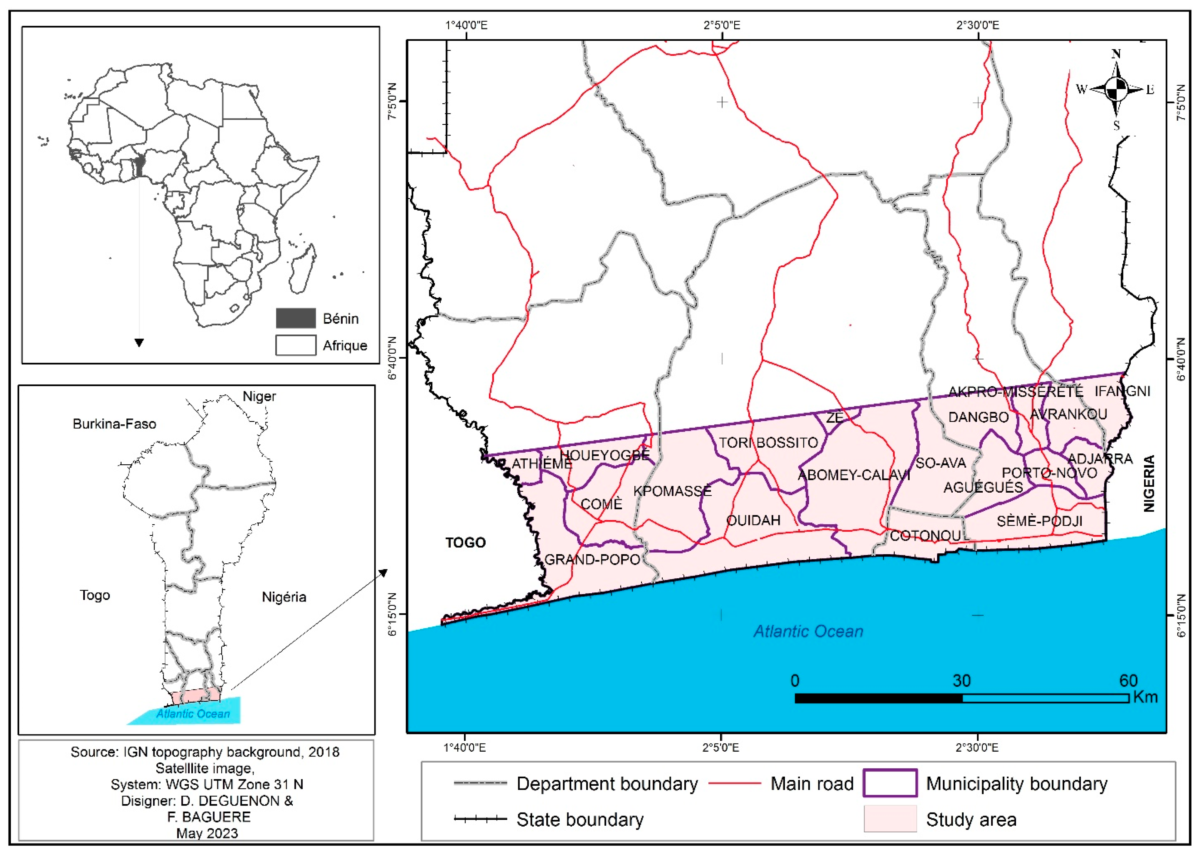
2.1. Study Area
2.2. Sea Level Affecting Marshes Model (SLAMM)
2.3. Machine Learning Approach
2.4. Greenhouse Gas Sequestration
- = Mass of greenhouse gases sequestered at a specific time, measured in terms of carbon dioxide (CO2) mass;
- (t) = Mass of carbon dioxide sequestered at the given time (CO2 mass);
- Amount of methane emitted at the specified time, measured in terms of methane mass (CH4 mass);
- 21 = Historically assumed 100-year global warming potential (GWP) for methane, as established in [32]. However, recent studies indicate that methane may have a considerably higher GWP of 34, as reported by Change in 2013.
3. Results
3.1. Sea-Level Modeling Using Machine Learning Method and the SLAMM
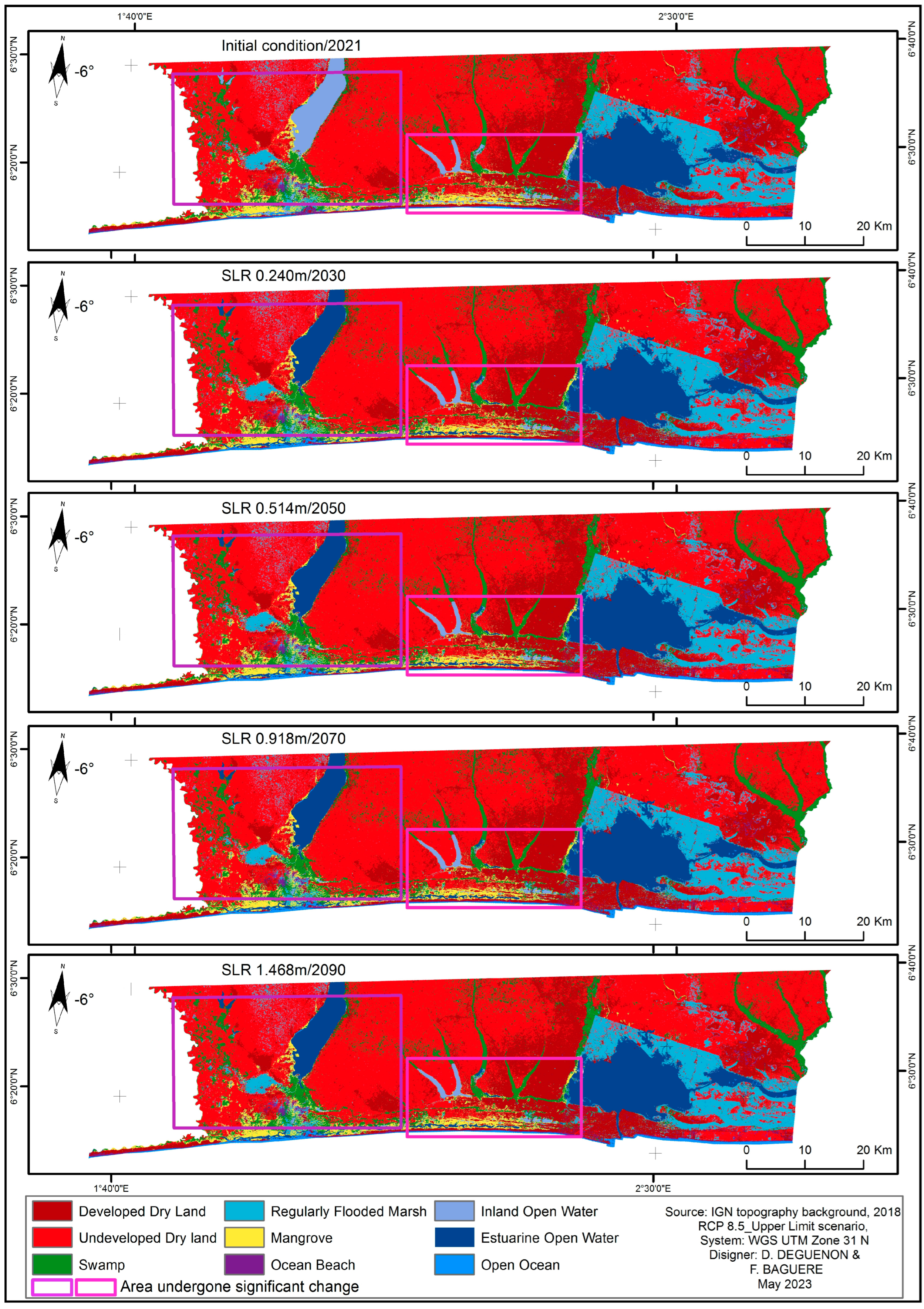
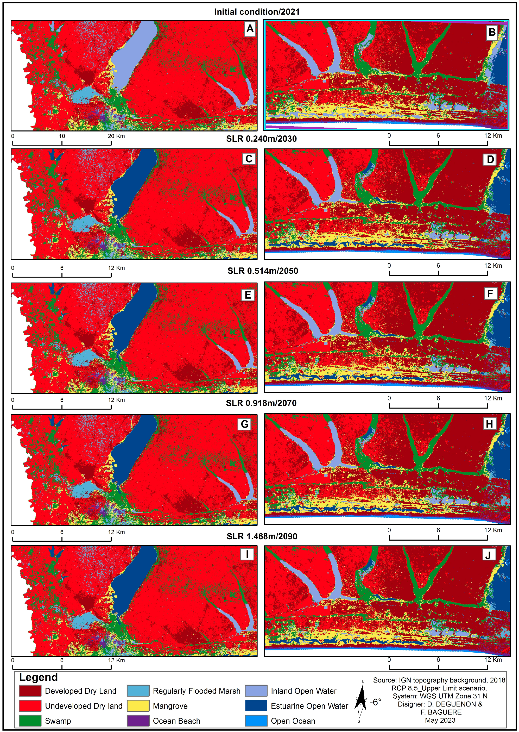
3.2. Expected Change on the Coast from the Combined Method: ML and SLAMM
- -
- Coastal erosion will worsen as a result of sea-level rise brought on by global warming. Benin’s coastline has a delicate ecology that is vulnerable to the harmful effects of climate change, including:
- ▪
- Rising sea and ocean levels (as depicted in Figure 5);
- ▪
- Apparent retreat of the coastline east of Cotonou;
- ▪
- Alterations in average rainfall patterns;
- ▪
- Heightened atmospheric temperature negatively impacting natural ecosystems, human communities, water resources, and coastal infrastructure.

- -
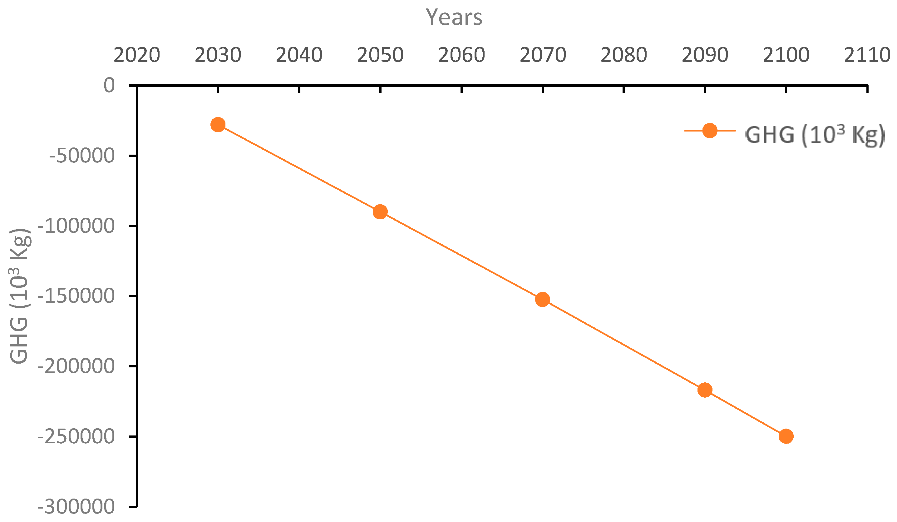
- Referring to the methodology developed by Vandebroek and Crooks at ESA PWA (2014) [34], the SLAMM employs a calculation process to estimate carbon sequestration based on land cover data obtained using the ML approach. This approach considers the amount of carbon stored within wetlands as well as the carbon emissions resulting from methane loss in freshwater ecosystems. Within our study area, there will be a noticeable annual decrease in the capacity to sequester greenhouse gases, particularly carbon (as depicted in Figure 6).
4. Discussion
4.1. Implications of Sea Level Rise
4.2. Carbon Sequestration and Greenhouse Gas Implications
4.3. Erosion
4.4. Inundation
4.5. Limitations and Future Research Directions
5. Recommendations
- Build Seawalls, Breakwaters, and Improved Drainage Systems: These physical interventions are crucial for protecting vulnerable urban areas from coastal erosion and flooding.
- Promote Sustainable Land-Use Practices: This recommendation highlights the importance of elevated construction and zoning regulations to ensure resilient urban planning.
- Implement Sustainable Fisheries: Responsible fishery management practices can ensure the long-term sustainability of fish stocks. This includes regulating catch limits and protecting critical breeding and nursery areas.
- Engage and Educate Local Communities: Community involvement and early warning systems are pivotal in adapting to changing coastal conditions.
- Establish Comprehensive Coastal Management Policies: The need for effective policies to manage saltwater intrusion and overall coastal resources is essential.
- Encourage Climate-Resilient Housing and Infrastructure: To safeguard communities, it is essential to promote resilient housing and infrastructure, as well as diversifying livelihoods for coastal residents.
- Invest in Continuous Research and International Cooperation: Ongoing research, data collection, and international collaboration are essential for developing effective adaptation strategies in response to sea-level rise.
6. Conclusions
Author Contributions
Funding
Informed Consent Statement
Data Availability Statement
Acknowledgments
Conflicts of Interest
References
- IPCC. Climate Change and Land: An IPCC Special Report on Climate Change, Desertification, Land Degradation, Sustainable Land Management, Food Security, and Greenhouse Gas Fluxes in Terrestrial Ecosystems; Climate Change and Land: An IPCC Special Report; IPCC: Geneva, Switzerland, 2019; pp. 1–864. [Google Scholar]
- Acclimaterra. Anticiper les Changements Climatiques Comité Scientifique Régional Acclimaterra Sous la Direction de Hervé Le Treut. Éditions Région Nouvelle-Aquitaine; Acclimaterra: Delft, The Netherlands, 2018. [Google Scholar]
- Neumann, B.; Vafeidis, A.T.; Zimmermann, J.; Nicholls, R.J. Future coastal population growth and exposure to sea-level rise and coastal flooding-a global assessment. PLoS ONE 2015, 10, e0118571. [Google Scholar] [CrossRef] [PubMed]
- Anderson, T.R.; Fletcher, C.H.; Barbee, M.M.; Romine, B.M.; Lemmo, S.; Delevaux, J.M. Modeling multiple sea level rise stresses reveals up to twice the land at risk compared to strictly passive flooding methods. Sci. Rep. 2018, 8, 14484. [Google Scholar] [CrossRef] [PubMed]
- Vitousek, S.; Barnard, P.L.; Fletcher, C.H.; Frazer, N.; Erikson, L.; Storlazzi, C.D. Doubling of coastal flooding frequency within decades due to sea-level rise. Sci. Rep. 2017, 7, 1399. [Google Scholar] [CrossRef] [PubMed]
- Intergovernmental Oceanographic Commission. Continental Approach. A Report to the African Union the African Science-Base for Coastal Adaptation; Intergovernmental Oceanographic Commission: Paris, France, 2023. [Google Scholar]
- Konko, Y.; Bagaram, B.; Julien, F.; Akpamou, K.G.; Kokou, K. Multitemporal Analysis of Coastal Erosion Based on Multisource Satellite Images in the South of the Mono Transboundary Biosphere Reserve in Togo (West Africa). OALib 2018, 05, 1–21. [Google Scholar] [CrossRef]
- Thepsiriamnuay, H.; Pumijumnong, N. Modelling Assessment of Sandy Beaches Erosion in Thailand. Environ. Nat. Resour. J. 2018, 17, 71–86. [Google Scholar] [CrossRef]
- Obama, B. The irreversible momentum of clean energy. Science 2017, 355, 126–129. [Google Scholar] [CrossRef]
- Dahl, K.A.; Fitzpatrick, M.F.; Spanger-Siegfried, E. Sea level rise drives increased tidal flooding frequency at tide gauges along the U.S. East and Gulf Coasts: Projections for 2030 and 2045. PLoS ONE 2017, 12, e0170949. [Google Scholar] [CrossRef] [PubMed]
- Dewi, R.S.; Bijker, W. Dynamics of shoreline changes in the coastal region of Sayung, Indonesia. Egypt. J. Remote. Sens. Space Sci. 2019, 23, 181–193. [Google Scholar] [CrossRef]
- Habel, S.; Fletcher, C.H.; Rotzoll, K.; El-Kadi, A.I. Development of a model to simulate groundwater inundation induced by sea-level rise and high tides in Honolulu, Hawaii. Water Res. 2017, 114, 122–134. [Google Scholar] [CrossRef]
- Payo, A.; Mukhopadhyay, A.; Hazra, S.; Ghosh, T.; Ghosh, S.; Brown, S.; Nicholls, R.J.; Bricheno, L.; Wolf, J.; Kay, S.; et al. Projected changes in area of the Sundarban mangrove forest in Bangladesh due to SLR by 2100. Clim. Change 2016, 139, 279–291. [Google Scholar] [CrossRef]
- Jenifer, S.; Hamilton, A.; Liang, M.; Clough, J.; Propato, M.; Haaf, L.; West Jordan, M. Application of the Sea-Level Affecting Marshes Model (SLAMM) to the Lower Delaware Bay, with a Focus on Salt Marsh Habitat; EPA: Washington, DC, USA, 2019. [Google Scholar]
- Callo-Concha, D. Farmer Perceptions and Climate Change Adaptation in the West Africa Sudan Savannah: Reality Check in Dassari, Benin, and Dano, Burkina Faso. Climate 2018, 6, 44. [Google Scholar] [CrossRef]
- Ndour, A.; Laïbi, R.A.; Sadio, M.; Degbe, C.G.; Diaw, A.T.; Oyédé, L.M.; Anthony, E.J.; Dussouillez, P.; Sambou, H.; Dièye, E.H.B. Management strategies for coastal erosion problems in west Africa: Analysis, issues, and constraints drawn from the examples of Senegal and Benin. Ocean Coast. Manag. 2018, 156, 92–106. [Google Scholar] [CrossRef]
- Rawson, A.; Brito, M.; Sabeur, Z. Spatial Modeling of Maritime Risk Using Machine Learning. Risk Anal. 2021, 42, 2291–2311. [Google Scholar] [CrossRef]
- Rimal, B.; Sharma, R.; Kunwar, R.; Keshtkar, H.; Stork, N.E.; Rijal, S.; Rahman, S.A.; Baral, H. Effects of land use and land cover change on ecosystem services in the Koshi River Basin, Eastern Nepal. Ecosyst. Serv. 2019, 38, 100963. [Google Scholar] [CrossRef]
- Sahour, H.; Gholami, V.; Vazifedan, M. A comparative analysis of statistical and machine learning techniques for mapping the spatial distribution of groundwater salinity in a coastal aquifer. J. Hydrol. 2020, 591, 125321. [Google Scholar] [CrossRef]
- Pham, B.T.; Luu, C.; Van Phong, T.; Nguyen, H.D.; Van Le, H.; Tran, T.Q.; Ta, H.T.; Prakash, I. Flood risk assessment using hybrid artificial intelligence models integrated with multi-criteria decision analysis in Quang Nam Province, Vietnam. J. Hydrol. 2020, 592, 125815. [Google Scholar] [CrossRef]
- Deguenon, S.D.D.M.; Baguere, O.F.; Teka, O.; Aheto, D.W.; Sinsin, B. Using of intensity analysis approach in Benin coastal zone (West Africa) to assess land use/land cover change for further decision making. Heliyon 2022, 8, e12384. [Google Scholar] [CrossRef]
- Tragaki, A.; Gallousi, C.; Karymbalis, E. Coastal Hazard Vulnerability Assessment Based on Geomorphic, Oceanographic and Demographic Parameters: The Case of the Peloponnese (Southern Greece). Land 2018, 7, 56. [Google Scholar] [CrossRef]
- Dahl, K.A.; Spanger-Siegfried, E.; Caldas, A.; Udvardy, S. Effective inundation of continental United States communities with 21st century sea level rise. Elementa Sci. Anthr. 2017, 5, 1–21. [Google Scholar] [CrossRef]
- Passeri, D.L.; Hagen, S.C.; Medeiros, S.C.; Bilskie, M.V.; Alizad, K.; Wang, D. The dynamic effects of sea level rise on low-gradient coastal landscapes: A review. Earth’s Futur. 2015, 3, 159–181. [Google Scholar] [CrossRef]
- Terorotua, H.; Duvat, K.E.; Maspataud, A.; Ouriqua, J. Assessing Perception of Climate Change by Representatives of Public Authorities and Designing Coastal Climate Services: Lessons Learnt from French Polynesia. Sec. Coast. Ocean. Process. 2020, 7, 160. [Google Scholar] [CrossRef]
- CEDEAO. Gestion Intégrée des Ressources en Eau en Afrique de l’Ouest. Axe de Travail: Renforcer les Capacités du Secteur; CEDEAO: Lagos, Nigeria, 2013. [Google Scholar]
- Troll, C. Seasonal Climates of the Earth. In Weltkarten zur Klimakunde/World Maps of Climatology; Springer: Berlin/Heidelberg, Germany, 1965; pp. 19–25. [Google Scholar] [CrossRef]
- Kolawolé Sikirou, A.; Boko, M. Le Bénin; Éditions du Flamboyant; EDICEF: Paris, France, 1993. [Google Scholar]
- DGEC. Description des Zones Marine et Cotiere d’Importance Ecologique ou Biologique (Zieb) Au Sud-Benin; Projet Gestion Integree de la Zone Marine et Cotiere Au Benin; Ministere du Cadre de Vie et du Developpement Durable: Porto Nuovo, Benin, 2019. [Google Scholar]
- Elliott, P.; Williams, H. Evaluating sea-level rise hazards on coastal archaeological sites, Trinity Bay, Texas. J. Isl. Coast. Archaeol. 2019, 16, 591–609. [Google Scholar] [CrossRef]
- Clough, J.S.; Park, R.A.; Propato, M.; Polaczyk, A.; Brennan, M.; Behrens, D.; Battalio, B.; Fuller, R. SLAMM 6.7 Technical Documentation; Warren Pinnacle Consulting Inc.: Waitsfield, VT, USA, 2016; Available online: http://warrenpinnacle.com/prof/SLAMM6/SLAMM_6.7_Technical_Documentation.pdf (accessed on 29 June 2023).
- Forster, A.; Schouten, S.; Baas, M.; Damsté, J.S.S. Mid-Cretaceous (Albian–Santonian) sea surface temperature record of the tropical Atlantic Ocean. Geology 2007, 35, 919–922. [Google Scholar] [CrossRef]
- World Bank. Plan d’Investissement Multisectoriel pour l’Adaptation aux Risques Cotiers Face aux Changements Climatiques au Benin Rapport Final; World Bank: Washington, DC, USA, 2017. [Google Scholar]
- Michael, F. Sea Level Rise and Monterey Bay. 2011. Available online: https://nmsmontereybay.blob.core.windows.net/montereybay-prod/media/resourcepro/reports/111206prep-future_change.pdf (accessed on 29 June 2023).
- Zhang, Y.; Cui, L.; Xie, D.; Jiang, J. Simulation and Prediction of Sea Level Rise Impact on the Distribution of Mangrove and Spartina alterniflora in Coastal China. Forests 2023, 14, 831. [Google Scholar] [CrossRef]
- Kirwan, M.L.; Temmerman, S.; Skeehan, E.E.; Guntenspergen, G.R.; Fagherazzi, S. Overestimation of marsh vulnerability to sea level rise. Nat. Clim. Change 2016, 6, 253–260. [Google Scholar] [CrossRef]
- Schuerch, M.; Spencer, T.; Temmerman, S.; Kirwan, M.L.; Wolff, C.; Lincke, D.; McOwen, C.J.; Pickering, M.D.; Reef, R.; Vafeidis, A.T.; et al. Future response of global coastal wetlands to sea-level rise. Nature 2018, 561, 231–234. [Google Scholar] [CrossRef]
- Zanvo, M.G.S.; Barima, Y.S.S.; Salako, K.V.; Koua, K.A.N.; Kolawole, M.A.; Assogbadjo, A.E.; Kakaï, R.G. Mapping spatio-temporal changes in mangroves cover and projection in 2050 of their future state in Benin. Bois Forets Trop. 2022, 350, 29–42. [Google Scholar] [CrossRef]
- Core Writing Team; Lee, H.; Romero, J. (Eds.) IPCC, 2023: Climate Change 2023: Synthesis Report. Contribution of Working Groups I, II and III to the Sixth Assessment Report of the Intergovernmental Panel on Climate Change; IPCC: Geneva, Switzerland, 2023. [Google Scholar] [CrossRef]
- Ramsar Convention on Wetlands. Global Wetland Outlook. 2018. Available online: https://greenallianceblog.org.uk/wp-content/uploads/2020/03/707e6-ramsargwo_english_web2019update.pdf (accessed on 29 June 2023).
- UNESCO. World Water Assessment Programme (United Nations), and UN-Water. Water and Climate Change; UNESCO: Paris, France, 2020. [Google Scholar]
- Beuchle, R.; Achard, F.; Bourgoin, C.; Vancutsem, C. Deforestation and Forest Degradation in the Amazon; Publication Office of the European Union: Luxembourg, 2022. [Google Scholar] [CrossRef]
- Basso, B.; Dumont, B.; Maestrini, B.; Shcherbak, I.; Robertson, G.P.; Porter, J.R.; Smith, P.; Paustian, K.; Grace, P.R.; Asseng, S.; et al. Soil Organic Carbon and Nitrogen Feedbacks on Crop Yields under Climate Change. Agric. Environ. Lett. 2018, 3, 180026. [Google Scholar] [CrossRef]
- Jamal, S.; Santoro, J. Urbanization in Sub-Saharan Africa-Meeting Challenges by Bridging Stakeholders; Center for Strategic & International Studies; CSIS: Washington, DC, USA, 2018; pp. 1–7. [Google Scholar]
- Giardino, A.; Schrijvershof, R.; Nederhoff, C.; de Vroeg, H.; Brière, C.; Tonnon, P.-K.; Caires, S.; Walstra, D.; Sosa, J.; van Verseveld, W.; et al. A quantitative assessment of human interventions and climate change on the West African sediment budget. Ocean Coast. Manag. 2018, 156, 249–265. [Google Scholar] [CrossRef]
- Lal, R. Soil Erosion and Gaseous Emissions. Appl. Sci. 2020, 10, 2784. [Google Scholar] [CrossRef]
- WACA ResIP-CCA. West Africa Coastal Areas Resilience Investment Project for Climate Change Adaptation (WACA ResIP-CCA); CPI: Palo Alto, CA, USA, 2018; p. 21. [Google Scholar]
- Croitoru, L.; Miranda, J.J.; Sarraf, M. The Cost of Coastal Zone Degradation in West Africa; World Bank: Washington, DC, USA, 2019. [Google Scholar] [CrossRef]
- He, Q.; Silliman, B.R. Climate Change, Human Impacts, and Coastal Ecosystems in the Anthropocene. Curr. Biol. 2019, 29, R1021–R1035. [Google Scholar] [CrossRef] [PubMed]

| Input file | Purpose |
|---|---|
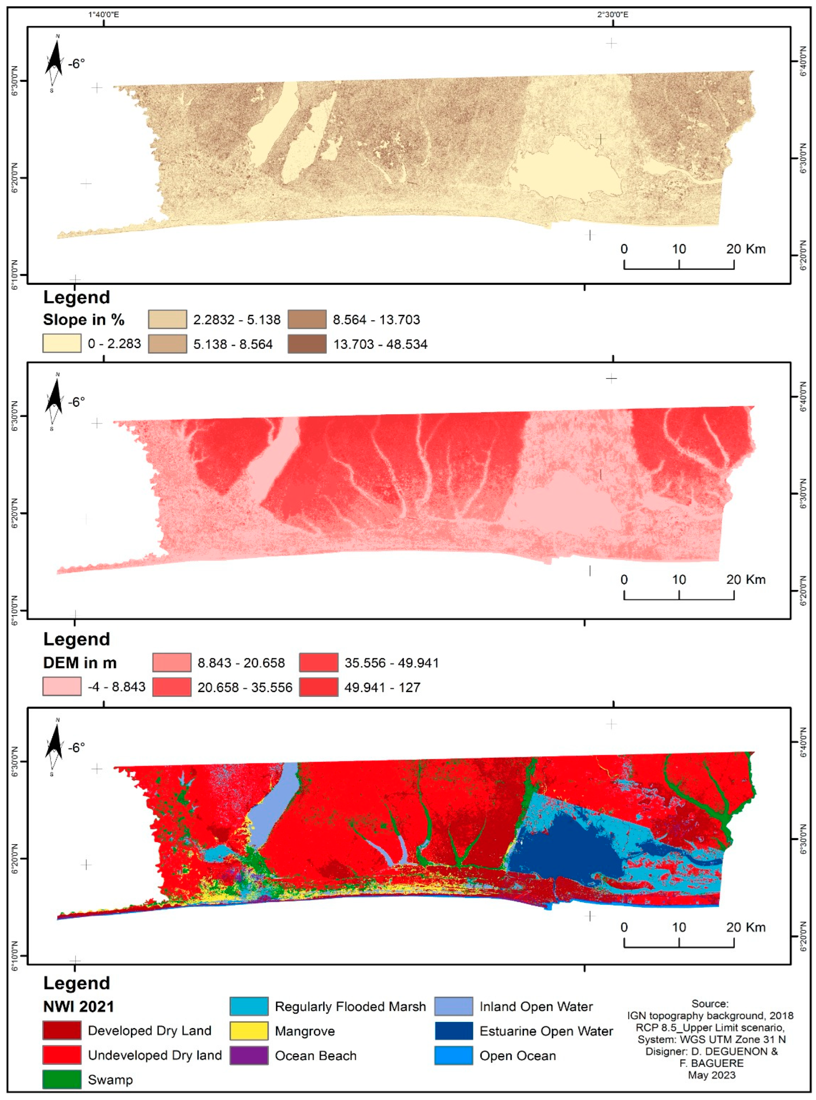
| DEM | Contains initial elevation data for individual cells and is utilized to generate a raster file representing slope information. |
| NWI | Created through the classification of satellite images using an Artificial Intelligence Tool called Support Vector Machine in ArcGIS Pro. The NWI file includes 9 wetland categories obtained from analyzing aerial imagery and considers the elevations of both saltwater and freshwater wetland classes. |
| SLOPE | Obtained through the utilization of ArcGIS Pro’s Slope Tool on the DEM; this particular file presents information regarding the highest and lowest elevations associated with individual cells measuring 10 × 10 m. |
| Parameter | Subsite | Description of Parameter |
|---|---|---|
| Description | Coastal area | Name of site or sub-site |
| NWI Photo Date (YYYY) | 2021 | Year of the satellite image used for the wetland classification |
| Marsh Erosion (horz. m/yr) | 0 | Horizontal erosion rates for marsh |
| DEM Date (YYYY) | 2010 | Year of the flight or survey for the elevation data |
| Historic Trend (mm/yr) | 2 | The annual sea-level rise rate in millimeters, historically utilized for assessing subsidence or uplift, unless a raster file detailing land movement is provided |
| Direction Offshore (N, S, E, W) | South | Direction of flow of water from the coast |
| Salt Elevation (m above MTL) | 0 | The elevation point where dry land freshwater wetlands starts |
| GT Great Diurnal Tide Range (m) | 0 | Same as the difference between Mean Higher High Water (MHHW) and Mean Lower Low Water (MLLW) |
| MTL-NAVD88 (m) | 1 | The correction for elevation determined using the average tide level |
| RCP 8.5_Upper Limit | 0.240 m | 0.514 m | 0.918 m | 1.468 m | |||||||||||
|---|---|---|---|---|---|---|---|---|---|---|---|---|---|---|---|
| Area | Area | Area | Area | ||||||||||||
| SLAMM Code | Land Cover Category | Initial Coverage | % | 2021 | 2030 | Change | 2021 | 2050 | Change | 2021 | 2070 | Change | 2021 | 2090 | Change |
| 1 | Developed Dry Land | 590.8 | 20.1 | 589.0 | 589.0 | −1.8 | 589.0 | 589.0 | −1.8 | 589.0 | 589.0 | −1.8 | 589.0 | 588.5 | −2.2 |
| 2 | Undeveloped Dryland | 1306.5 | 44.5 | 1305.6 | 1305.6 | −0.9 | 1305.6 | 1305.6 | −0.9 | 1305.6 | 1305.6 | −0.9 | 1305.6 | 1303.6 | −2.9 |
| 3 | Swamp | 262.0 | 8.9 | 258.3 | 258.3 | −3.7 | 258.3 | 258.3 | −3.7 | 258.3 | 258.3 | −3.7 | 258.3 | 256.9 | −5.1 |
| 8 | Regularly Flooded Marsh | 283.6 | 9.7 | 280.6 | 280.6 | −3.0 | 280.6 | 280.6 | −3.0 | 280.6 | 280.6 | −3.0 | 280.6 | 279.0 | −4.6 |
| 9 | Mangrove | 104.8 | 3.6 | 106.2 | 101.3 | −3.5 | 106.2 | 101.3 | −3.5 | 106.2 | 101.3 | −3.5 | 106.2 | 102.5 | −2.3 |
| 12 | Ocean Beach | 44.5 | 1.5 | 37.2 | 36.7 | −7.8 | 37.2 | 36.7 | −7.8 | 37.2 | 36.7 | −7.8 | 37.2 | 36.7 | −7.9 |
| 15 | Inland Open Water | 105.9 | 3.6 | 24.5 | 24.5 | −81.3 | 24.5 | 24.5 | −81.3 | 24.5 | 24.5 | −81.3 | 24.5 | 24.5 | −81.4 |
| 17 | Estuarine Open Water | 209.8 | 7.1 | 298.5 | 303.4 | 93.6 | 298.5 | 303.4 | 93.6 | 298.5 | 303.4 | 93.6 | 298.5 | 307.5 | 97.7 |
| 19 | Open Ocean | 26.5 | 0.9 | 34.5 | 34.9 | 8.4 | 34.5 | 34.9 | 8.4 | 34.5 | 34.9 | 8.4 | 34.5 | 35.0 | 8.5 |
| 2934.4 | 2934.3 | 2934.4 | 2934.4 | 2934.4 | 2934.3 | ||||||||||
Disclaimer/Publisher’s Note: The statements, opinions and data contained in all publications are solely those of the individual author(s) and contributor(s) and not of MDPI and/or the editor(s). MDPI and/or the editor(s) disclaim responsibility for any injury to people or property resulting from any ideas, methods, instructions or products referred to in the content. |
© 2023 by the authors. Licensee MDPI, Basel, Switzerland. This article is an open access article distributed under the terms and conditions of the Creative Commons Attribution (CC BY) license (https://creativecommons.org/licenses/by/4.0/).
Share and Cite
Deguenon, S.D.D.M.; Hounmenou, C.G.; Adade, R.; Teka, O.; Toko, I.I.; Aheto, D.W.; Sinsin, B. Simulation of the Impacts of Sea-Level Rise on Coastal Ecosystems in Benin Using a Combined Approach of Machine Learning and the Sea Level Affecting Marshes Model. Sustainability 2023, 15, 16001. https://doi.org/10.3390/su152216001
Deguenon SDDM, Hounmenou CG, Adade R, Teka O, Toko II, Aheto DW, Sinsin B. Simulation of the Impacts of Sea-Level Rise on Coastal Ecosystems in Benin Using a Combined Approach of Machine Learning and the Sea Level Affecting Marshes Model. Sustainability. 2023; 15(22):16001. https://doi.org/10.3390/su152216001
Chicago/Turabian StyleDeguenon, Sèna Donalde Dolorès Marguerite, Castro Gbêmêmali Hounmenou, Richard Adade, Oscar Teka, Ismaila Imorou Toko, Denis Worlanyo Aheto, and Brice Sinsin. 2023. "Simulation of the Impacts of Sea-Level Rise on Coastal Ecosystems in Benin Using a Combined Approach of Machine Learning and the Sea Level Affecting Marshes Model" Sustainability 15, no. 22: 16001. https://doi.org/10.3390/su152216001
APA StyleDeguenon, S. D. D. M., Hounmenou, C. G., Adade, R., Teka, O., Toko, I. I., Aheto, D. W., & Sinsin, B. (2023). Simulation of the Impacts of Sea-Level Rise on Coastal Ecosystems in Benin Using a Combined Approach of Machine Learning and the Sea Level Affecting Marshes Model. Sustainability, 15(22), 16001. https://doi.org/10.3390/su152216001