Maritime Network Analysis Based on Geographic Information System for Water Supply Using Shipboard Seawater Desalination System
Abstract
1. Introduction
2. Materials and Methods
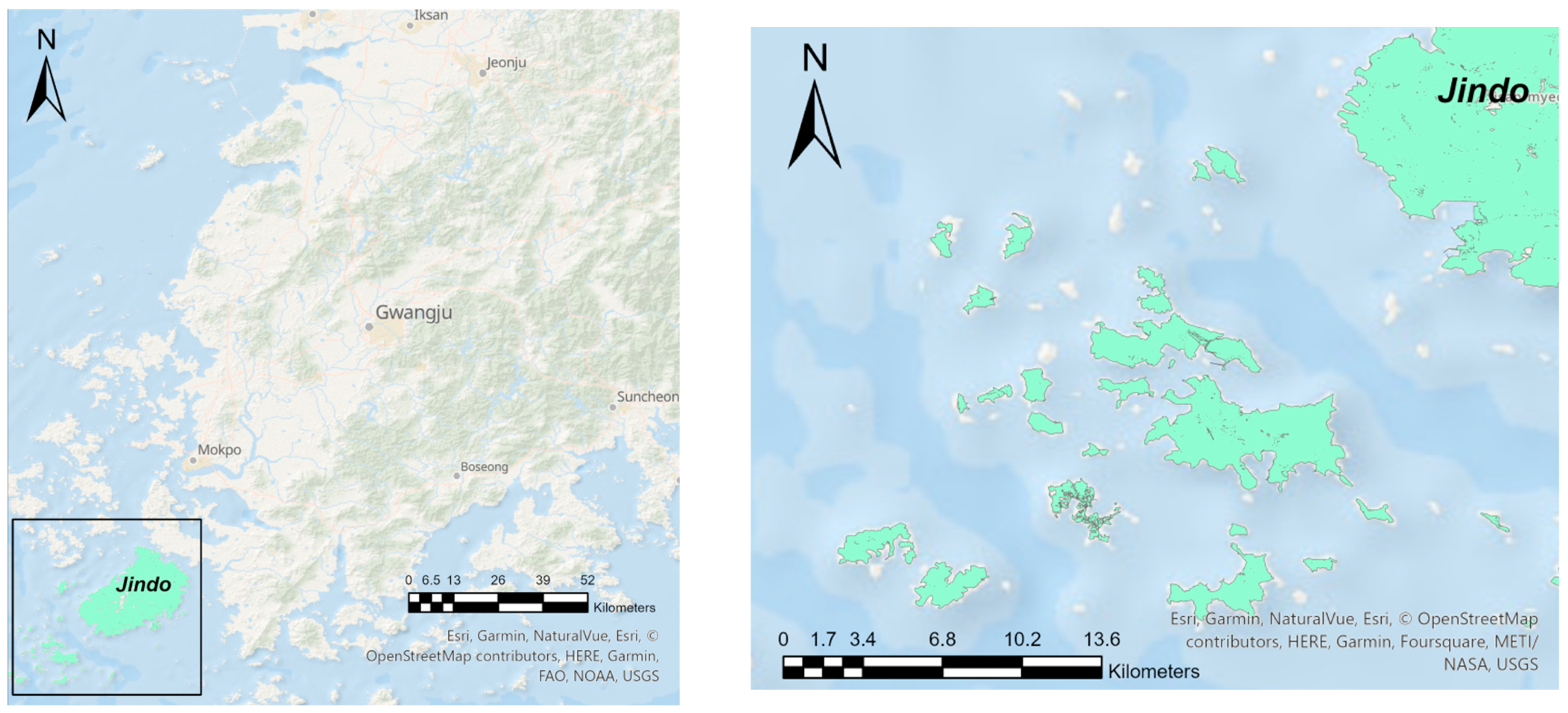
2.1. Study Areas
2.2. Shipboard Seawater Desalination Project
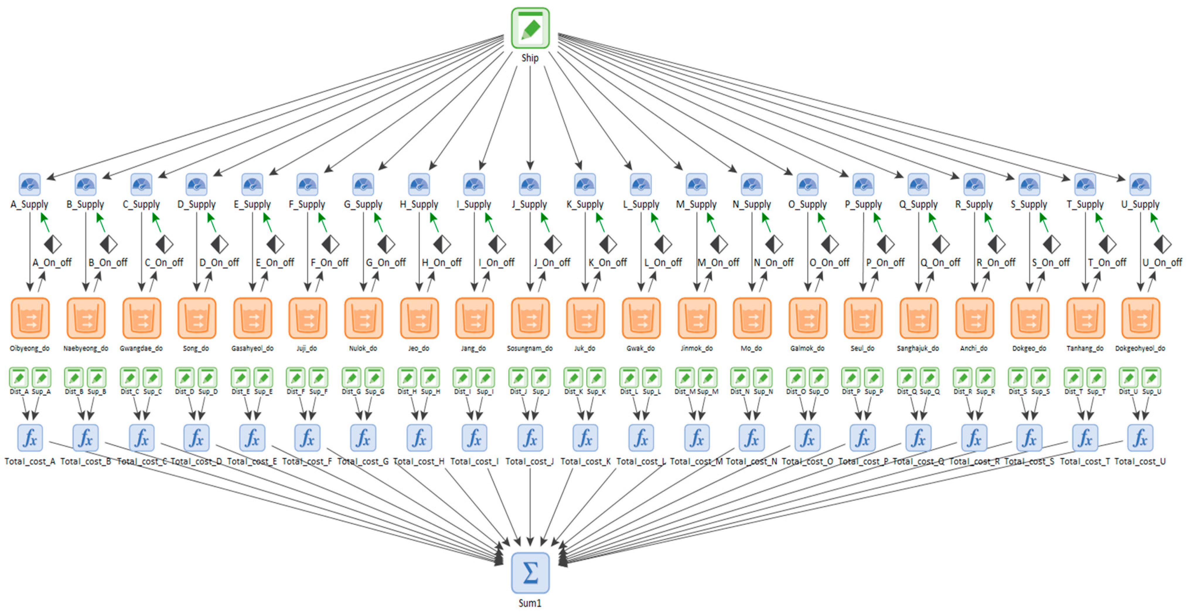
2.3. GoldSim Simulation
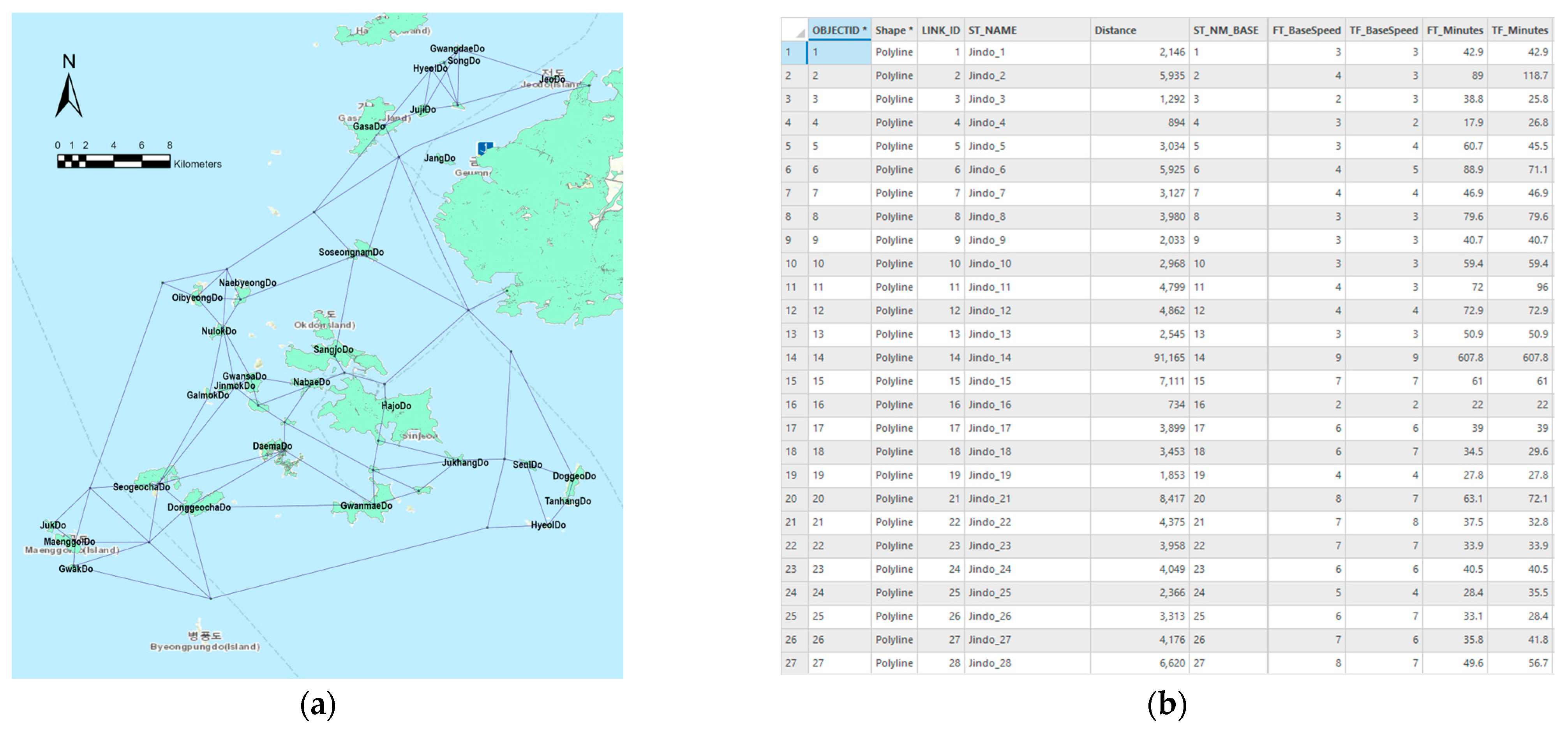
2.4. Building the Network Dataset
2.4.1. Data Preparation
- (1)
- A route that can be operated smoothly without obstacles in the movement route of the ship
- (2)
- Deceleration section due to fish farms and reefs
- (3)
- Slow movement between areas where farms are concentrated or between small islands
- (4)
- Berthing to port.
2.4.2. Network Dataset Creation
2.5. Network Analysis
3. Results
3.1. Existing Model Using Water Supply Shipment (As-Is)
3.1.1. Verification of the Stability of Water Supply
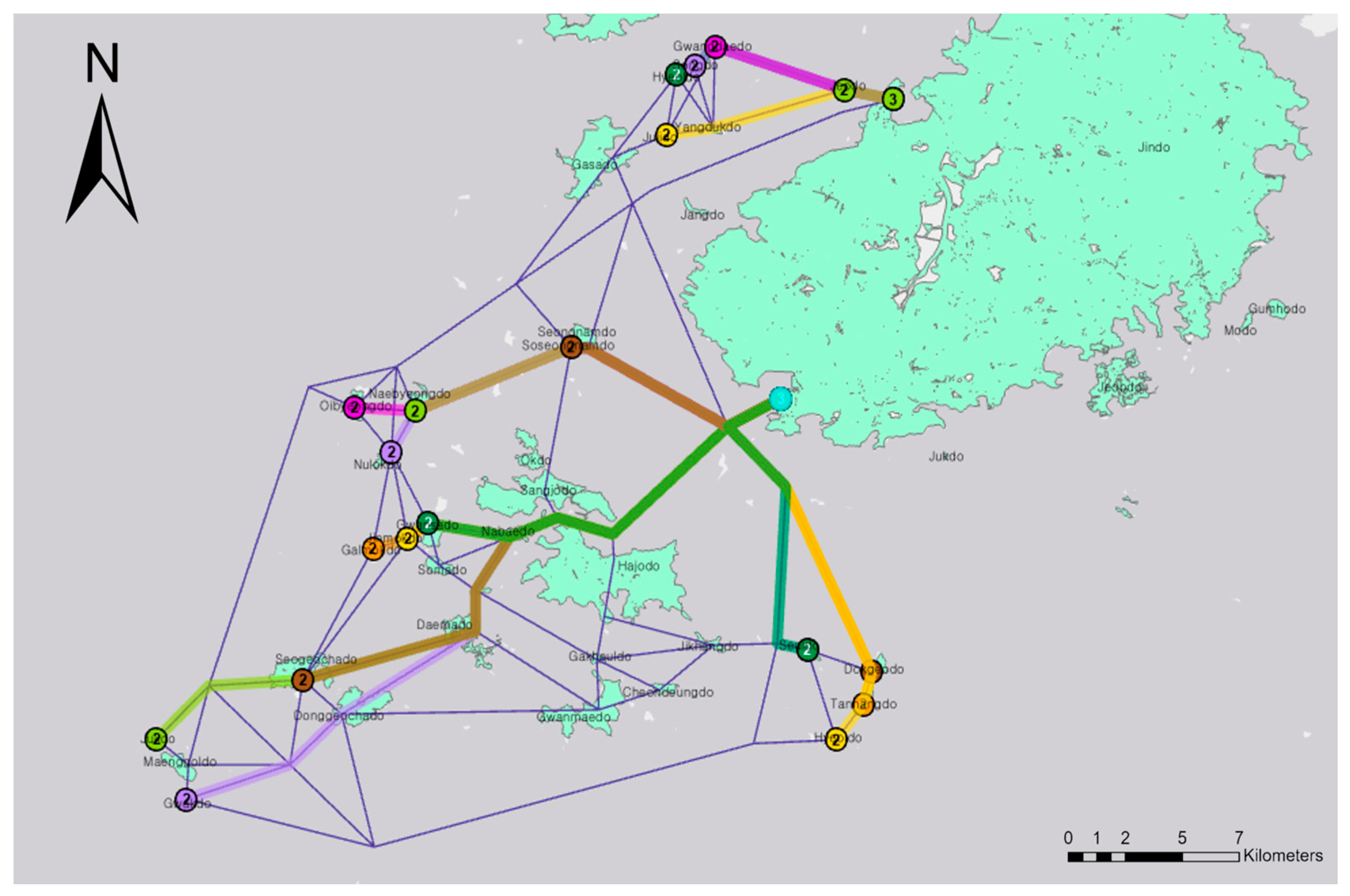
3.1.2. Existing Operation Route and Distance Calculation of Water Supply Shipment
3.2. Application of the Shipboard Desalination Ship (To-Be)
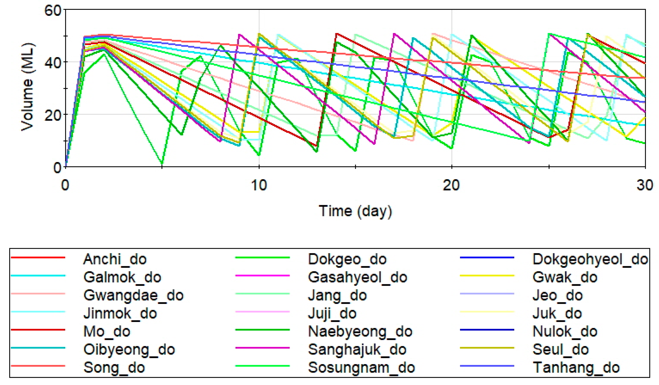
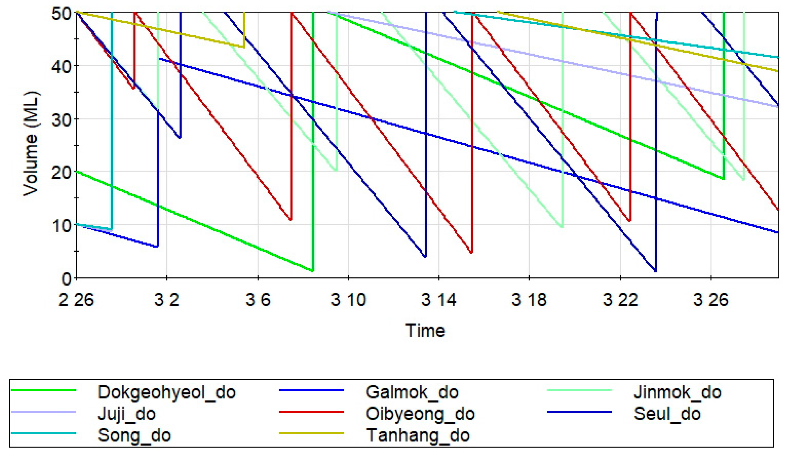
3.2.1. Verification of the Stability of Water Supply
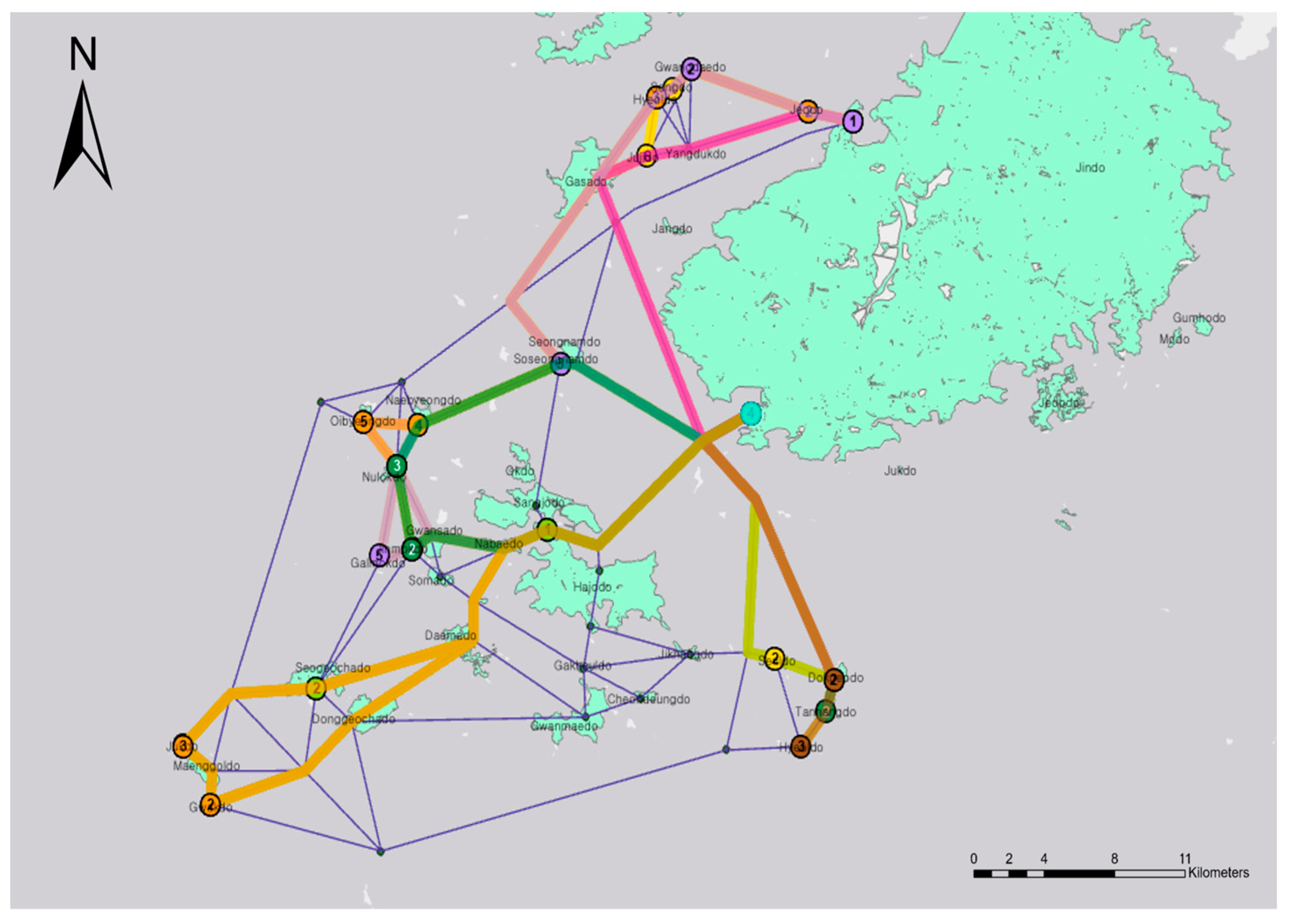
3.2.2. Calculation of the Travel Route and Distance of the Shipboard Desalination Ship
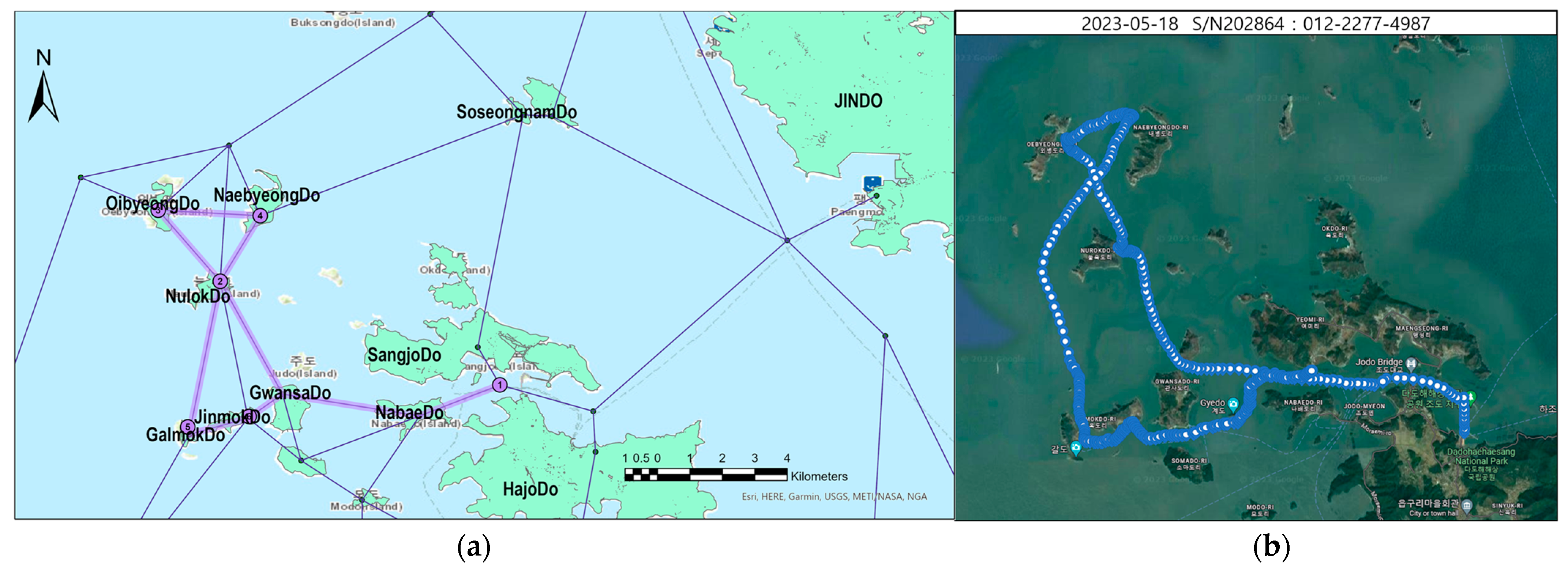
3.2.3. Verification of Route Results through Actual Travel
4. Conclusions
- The existing water supply method using land island round trips has many unstable factors and high costs depending on the climate and water supply shipment operation.
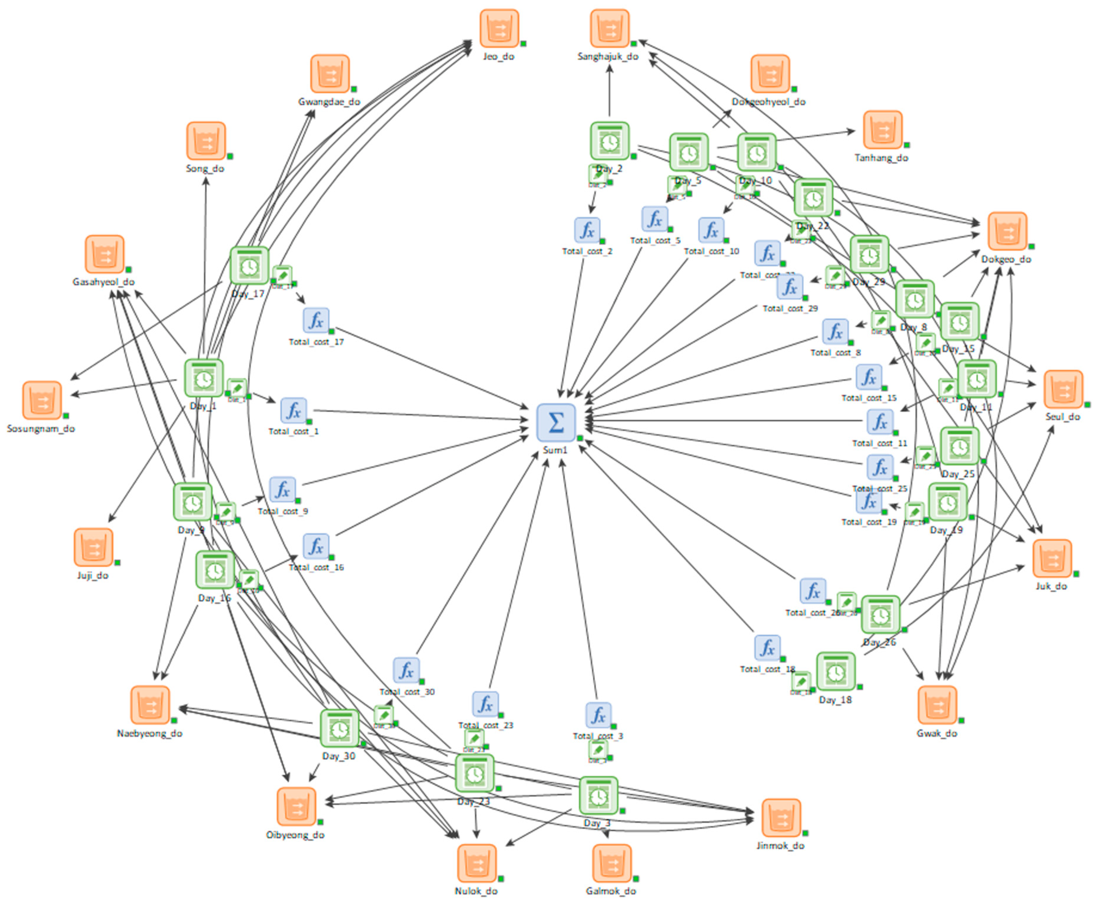
- An operation schedule was established, and a shipboard desalination ship model was applied to the GoldSim simulation program to address these shortcomings, which indicated a stable water supply.
- Furthermore, the optimal route, travel distance, and time determined using network analysis were compared with those of the existing water supply shipment.
- The total monthly travel distance decreased by more than 55% from 2153 km during water supply shipment to 968 km using DREAMS and was directly related to the water supply operation cost.
- Therefore, using the shipboard desalination ship is expected to considerably reduce the operation cost.
Author Contributions
Funding
Institutional Review Board Statement
Informed Consent Statement
Data Availability Statement
Conflicts of Interest
References
- Ahmed, S.; Ibrahim, R.F. GIS-based network analysis for the roads network of the greater Cairo Area. In Proceedings of the International Conference on Applied Research in Computer Science and Engineering 2017, Beirut, Lebanon, 22–23 June 2017. [Google Scholar]
- Athira, G.; Bahurudeen, A.; Vishnu, V.S. Availability and Accessibility of Sugarcane Bagasse Ash for its Utilization in Indian Cement Plants: A GIS-Based Network Analysis. Sugar Tech 2020, 22, 1038–1056. [Google Scholar] [CrossRef]
- Bae, S.; Lee, S.-H.; Yoo, S.-H.; Kim, T. Analysis of Drought Intensity and Trends Using the Modified SPEI in South Korea from 1981 to 2010. Water 2018, 10, 327. [Google Scholar] [CrossRef]
- Bae, Y.J.; Lee, H.J.; Jung, B.W. Korean Climate Change Assessment Report 2020; Minister of Environment: Seoul, Republic of Korea, 2020.
- Boeing, G. Urban street network analysis in a computational notebook. arXiv 2020, arXiv:2001.06505. [Google Scholar] [CrossRef]
- Chu, K.H.; Oh, B.G.; Kook, S.H.; Hwang, M.H. Operational strategies for brackish water desalination plants in island regions of South Korea. J. Clean. Prod. 2021, 278, 123540. [Google Scholar] [CrossRef]
- Das, D.; Ojha, A.K.; Kramsapi, H. Road network analysis of Guwahati city using GIS. SN Appl. Sci. 2019, 1, 906. [Google Scholar] [CrossRef]
- Dias, T.W.K.I.M.; Wijeweera, K.P. Assessing the walk-score of walking paths in Kandy City area for better walking experience for the tourists. J. Inst. Eng. 2021, 54, 27–38. [Google Scholar] [CrossRef]
- Gibson, J.; Deng, X.; Boe-Gibson, G.; Rozelle, S.; Huang, J. Which households are most distant from health centers in rural China? Evidence from a GIS network analysis. Geo J. 2011, 76, 245–255. [Google Scholar] [CrossRef][Green Version]
- Gnawali, K.; Han, K.H.; Geem, Z.W.; Jun, K.S.; Yum, K.T. Economic Dispatch Optimization of Multi-Water Resources: A Case Study of an Island in South Korea. Sustainability 2019, 11, 5964. [Google Scholar] [CrossRef]
- GoldSim Technology Group. Strategic Planning Applications Using GoldSim. White Paper. 2017. Available online: https://www.goldsim.com/Web/Applications/WhitePapers/ (accessed on 6 November 2020).
- Hepler, K.C. Characterization of Pressurized Wash for Decontamination of Porous Building Materials and a Goldsim Model for Recycling Contaminated Wash. Master’s Thesis, University of Illinois at Urbana-Champaign, Champaign, IL, USA, 2017. Available online: http://hdl.handle.net/2142/98301 (accessed on 12 December 2020).
- Hou, S.; Li, H.; Zhang, H. An open air–vapor compression refrigeration system for air-conditioning and desalination on ship. Desalination 2008, 222, 646–655. [Google Scholar] [CrossRef]
- Xu, Y.; Zhu, B.-K.; Xu, Y.-Y. Pilot test of vacuum membrane distillation for seawater desalination on a ship. Desalination 2006, 189, 165–169. [Google Scholar] [CrossRef]
- Zhao, Y.; Duan, L.; Slawomir, W. Hermanowicz, Influence of water transport characteristics on membrane internal conductive structure in forward osmosis microbial fuel cell. J. Mol. Liq. 2023, 380, 121704. [Google Scholar] [CrossRef]
- Gao, Q.; Duan, L.; Zhao, Y. Evaluation and optimization of reverse osmosis pretreatment technology using the modified intermediate blocking model. J. Clean. Prod. 2023, 417, 138029. [Google Scholar] [CrossRef]
- Hetamsaria, P.; Matori, A.N.B. Applications of network analysis features in GIS. J. Eng. 2019, 3, 46–54. Available online: https://myjms.mohe.gov.my/index.php/paje/article/view/6651 (accessed on 10 May 2021).
- Elhag, A.R.; Elhag, A.A.; Sideeg, S.E.K. Route network analysis in Khartoum City. JECS 2016, 17, 50–57. Available online: https://repository.sustech.edu/handle/123456789/16648 (accessed on 10 May 2021).
- Forkuo, E.K.; Quaye-Ballard, J.A. GIS based fire emergency response system. Int. J. Remote Sens. 2013, 2, 32–40. [Google Scholar]
- Jin, Y.K.; Lee, S.H.; Jeong, T.M.; Kang, S.U. Estimation of supplement-eeduction amounts of water supply in a reservoir system operation using a Monte Carlo Simulation. J. Korean Soc. Hazard Mitig. 2019, 7, 87–94. [Google Scholar] [CrossRef]
- Wohlwend, J.L.; Hamm, L.L. GoldSim E-Area Low-Level Waste Facility Aquifer Zone Model Calibration Methodology; U.S. Department of Energy: New Ellenton, SC, USA, 2020. [CrossRef]
- Kim, D.-W.; Byun, H.-R.; Choi, K.-S.; Oh, S.-B. A Spatiotemporal Analysis of Historical Droughts in Korea. J. Appl. Meteorol. Climatol. 2011, 50, 1895–1912. [Google Scholar] [CrossRef]
- Lee, Y.M.; Jeong, J.T. Understanding and their application of GoldSim transport pathways to mass Transport simulation. J. Nucl. Fuel Cycle Waste Technol. 2014, 12, 133–151. [Google Scholar] [CrossRef]
- Lee, Y.H.; Hong, W.H.; Lee, J.S. The vulnerability assessment of water supply through the analysis of emergency water shortage in cut off water supply-prone island area. J. Korea Plan. Assoc. 2014, 30, 253–260. [Google Scholar] [CrossRef]
- Lee, Y.M.; Hwang, Y.S. A GoldSim model for the safety assessment of an HLW repository. Prog. Nucl. Energy 2009, 51, 746–759. [Google Scholar] [CrossRef]
- Lee, J.H.; Park, S.Y.; Chen, J. Extreme drought hotspot analysis for adaptation to a changing climate: Assessment of applicability to the five major river basins of the Korean Peninsula. Int. J. Climatol. 2018, 38, 4025–4032. [Google Scholar] [CrossRef]
- Moon, Y.R.; Kang, Y.S.; Park, N.S. A Study of Water Supply and Use in Small Islands; Basic Research Report; Korea Environment Institute: Incheon, Republic of Korea, 2009; pp. 1–3. [Google Scholar]
- Moon, Y.R.; Lee, M.J.; Kim, J.G. Guideline for Environmentally Friendly Water Supply Plans in Small Islands; Research Report; Korea Environment Institute: Incheon, Republic of Korea, 2010; pp. 1–3. [Google Scholar]
- Chen, S.; Zhuang, D. Evolution and Evaluation of the Guangzhou Metro Network Topology Based on an Integration of Complex Network Analysis and GIS. Sustainability 2020, 12, 538. [Google Scholar] [CrossRef]
- Shim, I.T.; Hong, B.C.; Kim, E.J.; Hwang, T.M. Vulnerability assessment of drought of small island areas in Korea. J. Korean Soc. Water Wastewater 2019, 33, 341–351. [Google Scholar] [CrossRef]
- Trenggana, S. The accessibility level of Cigudeg Village as prospective capital city of West Bogor Regency. Int. J. Environ. Agric. Biotechnol. 2019, 4, 561–580. [Google Scholar] [CrossRef]
- Weththasinghe, W.A.S.S.; Bandar, J.M.S.J. Systems approach to develop high mobility road network plan for Sri Lanka. J. Inst. Eng. 2021, LIV, 61–67. [Google Scholar] [CrossRef]
- Won, J.E.; Choi, J.H.; Kim, S.D. Two ways to quantify Korean drought frequency: Partial duration series and bivariate exponential distribution, and application to climate change. Atmosphere 2020, 11, 476. [Google Scholar] [CrossRef]


| Latitude | Longitude | Number of Households | Number of Residents | Amount of Water Usage (t d−1) | |
|---|---|---|---|---|---|
| Oibyeong do | 34.37228 | 125.9386 | 16 | 19 | 5.7 |
| Naebyeong do | 34.37123 | 125.9674 | 16 | 27 | 8.1 |
| Gwangdae do | 34.52888 | 126.1069 | 6 | 8 | 2.4 |
| Song do | 34.51986 | 126.0968 | 1 | 2 | 0.6 |
| Gasahyeol do | 34.51582 | 126.0878 | 9 | 17 | 5.1 |
| Juji do | 34.48885 | 126.0821 | 2 | 3 | 0.9 |
| Nulok do | 34.34891 | 125.9532 | 13 | 20 | 6 |
| Jeo do | 34.50888 | 126.1651 | 17 | 19 | 5.7 |
| Sosungnam do | 34.39667 | 126.0373 | 5 | 6 | 1.8 |
| Juk do | 34.2235 | 125.8459 | 13 | 18 | 5.4 |
| Gwak do | 34.19686 | 125.859 | 9 | 16 | 4.8 |
| Jinmok do | 34.31126 | 125.9578 | 13 | 17 | 5.1 |
| Galmok do | 34.30801 | 125.9446 | 3 | 4 | 1.2 |
| Seul do | 34.26292 | 126.1504 | 12 | 19 | 5.7 |
| Sanghajuk do | 34.24848 | 125.9252 | 13 | 20 | 6 |
| Dokgeo do | 34.25101 | 126.1804 | 25 | 48 | 14.4 |
| Tanhang do | 34.23873 | 126.1761 | 3 | 3 | 0.9 |
| Attribute | Value | |
|---|---|---|
| Shipment | Service speed | 7~9 knot |
| Gross Tonnage | 1800 ton | |
| Number of staffs on board | 10 | |
| Size (Length * Width) | 70.9 m × 24.0 m | |
| Draft | 4 m | |
| RO System | Model | LG SW 400 GR |
| Effective area | 37.2 m2/module | |
| Number of modules | 7 modules/vessel | |
| Number of vessels | 5 vessels/rack | |
| Number of racks | 1 rack | |
| Operating flux | 39.5 LMH | |
| Elements | Icon | Functions |
|---|---|---|
| Storage elements |  | Elements for calculating changes in storage tank capacity over time based on the set inflow and outflow |
| Input elements |  | Elements for setting inflow. The input variables can be set according to time-series data and probability normal distribution. |
| Event elements |  | Functions for manipulating input elements and function elements based on set events (e.g., IF function and storage tank set capacity) |
| Function elements |  | Elements that include functions or equations that can be calculated by integrating the results between elements |
| Values | Type | Range of Value |
|---|---|---|
| Wide road, no obstruction | 1 | |
| A few fish farms, submerged rocks | 0.7~0.9 | |
| A lot of fish farms, narrow road | 0.4~0.6 | |
| Berthing | 0.1~0.2 |
| Destination | Travel Distance (m) | Travel Time (min) | Supply Frequency per Month |
|---|---|---|---|
| Dokgeohyeol do | 39,990 | 263 | 2 |
| Dokgeo do | 32,534 | 173 | 9 |
| Galmok do | 41,871 | 312 | 1 |
| Gasahyeol do | 20,535 | 241 | 4 |
| Gwak do | 69,494 | 469 | 3 |
| Gwangdae do | 16,163 | 182 | 2 |
| Jeo do | 4292 | 52 | 4 |
| Jinmok do | 38,705 | 274 | 4 |
| Juji do | 20,209 | 210 | 1 |
| Juk do | 69,835 | 476 | 4 |
| Naebyeong do | 35,779 | 239 | 5 |
| Nulok do | 40,299 | 276 | 4 |
| Oibyeong do | 40,990 | 288 | 4 |
| Sanghajuk do | 54,831 | 366 | 4 |
| Seul do | 30,987 | 186 | 4 |
| Soseongnam do | 21,007 | 146 | 2 |
| Song do | 18,747 | 217 | 1 |
| Tanhang do | 35,794 | 212 | 1 |
| Total | 2,153,021 | 14,923 | 59 |
| Monday | Tuesday | Wednesday | Thursday | Friday |
|---|---|---|---|---|
| 1st | 2nd | 3rd | 4th | 5th |
| Group 1 | Group 2 | Group 6 | - | Group 9 |
| 8th | 9th | 10th | 11th | 12th |
| Group 10 | Group 11 | Group 2 | Group 3 | - |
| 15th | 16th | 17th | 18th | 19th |
| Group 10 | Group 11 | Group 4 | Group 3 | Group 2 |
| 22nd | 23rd | 24th | 25th | 26th |
| Group 10 | Group 11 | - | Group 3 | Group 2 |
| 29th | 30th | 31st | ||
| Group 5 | Group 7 | Group 8 |
| Destination | Travel Distance (m) | Travel Time (min) | Repeat Times per Month |
|---|---|---|---|
| Route 1 | 37,630 | 333 | 1 |
| Route 2 | 60,819 | 426 | 4 |
| Route 3 | 34,747 | 212 | 3 |
| Route 4 | 36,979 | 316 | 1 |
| Route 5 | 39,990 | 263 | 1 |
| Route 6 | 30,519 | 280 | 1 |
| Route 7 | 43,763 | 313 | 1 |
| Route 8 | 73,201 | 508 | 1 |
| Route 9 | 38,006 | 246 | 1 |
| Route 10 | 56,559 | 375 | 3 |
| Route 11 | 50,401 | 439 | 3 |
| Total | 968,486 | 7041 | 20 |
Disclaimer/Publisher’s Note: The statements, opinions and data contained in all publications are solely those of the individual author(s) and contributor(s) and not of MDPI and/or the editor(s). MDPI and/or the editor(s) disclaim responsibility for any injury to people or property resulting from any ideas, methods, instructions or products referred to in the content. |
© 2023 by the authors. Licensee MDPI, Basel, Switzerland. This article is an open access article distributed under the terms and conditions of the Creative Commons Attribution (CC BY) license (https://creativecommons.org/licenses/by/4.0/).
Share and Cite
Shin, Y.; Koo, J.; Lee, J.; Nam, S.-H.; Kim, E.; Hwang, T.-M. Maritime Network Analysis Based on Geographic Information System for Water Supply Using Shipboard Seawater Desalination System. Sustainability 2023, 15, 15746. https://doi.org/10.3390/su152215746
Shin Y, Koo J, Lee J, Nam S-H, Kim E, Hwang T-M. Maritime Network Analysis Based on Geographic Information System for Water Supply Using Shipboard Seawater Desalination System. Sustainability. 2023; 15(22):15746. https://doi.org/10.3390/su152215746
Chicago/Turabian StyleShin, Yonghyun, Jaewuk Koo, Juwon Lee, Sook-Hyun Nam, Eunju Kim, and Tae-Mun Hwang. 2023. "Maritime Network Analysis Based on Geographic Information System for Water Supply Using Shipboard Seawater Desalination System" Sustainability 15, no. 22: 15746. https://doi.org/10.3390/su152215746
APA StyleShin, Y., Koo, J., Lee, J., Nam, S.-H., Kim, E., & Hwang, T.-M. (2023). Maritime Network Analysis Based on Geographic Information System for Water Supply Using Shipboard Seawater Desalination System. Sustainability, 15(22), 15746. https://doi.org/10.3390/su152215746


