Article

A Study on Resource Carrying Capacity and Early Warning of Urban Agglomerations of the Yellow River Basin Based on Sustainable Development Goals, China

School of Geography and Planning, Ningxia University, Yinchuan 750021, China
*
Author to whom correspondence should be addressed.
Sustainability 2023, 15(19), 14577; https://doi.org/10.3390/su151914577
Submission received: 9 August 2023 / Revised: 24 September 2023 / Accepted: 28 September 2023 / Published: 8 October 2023
(This article belongs to the Section Sustainable Urban and Rural Development)

Abstract

:
The Yellow River Basin is an essential ecological barrier in China, but it is relatively underdeveloped. The human–land relationship needs to be coordinated, and the ecological environment is fragile, which seriously restricts the sustainable development of the urban agglomeration in the Yellow River Basin. In this study, a “five-dimensional integrated” comprehensive carrying capacity evaluation model is constructed using the five dimensions of water, land, ecology, monitoring, and early warning to evaluate its resource carrying capacity quantitatively. It constructs an early warning system of the resource carrying capacity based on the quantitative evaluation results and monitors the state of the resource carrying capacity. The results show that (1) seven major urban agglomerations’ populations, grain productions, and land are surplus, and 50.85% of prefecture-level cities have food surpluses regarding human–food relationships. (2) There are shortages in the urban agglomeration’s water resources and a deficit in the water resource carrying capacity. (3) The average ecological carrying capacity index is 0.519, indicating a state of ecological affluence. (4) The comprehensive resource carrying capacity is defined as level-three heavy-load conditions, while 67%, 22%, and 14% of cities have level-one, -two, and -three heavy-load conditions, respectively. This study can aid in the monitoring of the resource carrying status of the Yellow River Basin. These results provide a scientific basis for effectively restraining the utilization and development of natural resources in the Yellow River Basin. It can also provide a research paradigm for the world’s river basins, as well as the sustainable development of man and nature in the world.

1. Introduction

Sustainable development research focuses on resources and the environment. To measure the reasonableness of a population, resources, and environmental allocation, a comprehensive resource environment carrying capacity (RECC) evaluation is a crucial method. This method has significance in the guidance of scientific research, regional economic judgment, social development potential, and optimization of territorial spatial patterns. The resource carrying capacity is a scientific proposition for exploring the “maximum load” of human limits [1]. It also involves the human–nature relationship and the human destiny community [2]. With socioeconomic development and population growth, natural resources exploitation and ecosystem destruction have constrained sustainable development. The core of sustainable development is the coordination and unity of economic development, resource protection, and ecological and environmental protection. According to the 2030 Sustainable Development Goals (SDGs) and their evaluation indicators, ecological resources, such as water, arable land, woodland, grassland, and wetland resources, as well as their carrying capacity, are important targets of the sustainable development goals. Regional resource and environmental carrying capacity is the basis for formulating sustainable development goals. Only by accurately measuring the regional resource and environmental carrying capacity can social and economic activities be guided and developed that are scientifically based on resource conservation and environmental protection and, thus, realize the sustainable development of the district and the city from the surface. Thus, it is crucial to maintain harmony between human society and the natural environment and improve the carrying capacity of resources. A long-term monitoring mechanism and early warning system for resource development and utilization are important for the scientific planning of regional natural resources, environmental protection, and sustainable development [3].
The origin of the carrying capacity concept comes from biology and ecology [4], and the resource carrying capacity has been widely evaluated, from studies that assess single elements to much more comprehensive evaluations [5], which primarily focus on the study of the land carrying capacity [6], water carrying capacity [7,8], ecological carrying capacity [9], and other elements with potent relevance. The specific measures of resource carrying capacity include the system dynamics model [10,11], multiobjective function [12], neural network [13], ecological footprint method [14], principal component analysis [15], hierarchical analysis [16], and the TOPSIS method [17], which have all undergone development from an original focus on single resource constraints to comprehensive assessments of the human occupation of resources. The increasing depth of research has meant that resource carrying capacity has gradually changed from a classification to a synthesis, from qualitative to quantitative assessments, and from evaluating the current carrying capacity to developing monitoring and early warning strategies [3]. Some studies assess regions, resource carrying capacities, and monitoring and early warning systems [18]. Regarding the research scale, they focus on the national [19,20], basin [21,22], and urban agglomeration [23] levels. In the study of the carrying capacity of the Yellow River Basin, mainly land resources [17], water resources [24,25], a socioeconomic–resource–environmental multifactor combination [26,27,28], and other aspects are explored. Some scholars combine SDG indicators to construct an indicator system to evaluate from different perspectives the carrying capacity in their research on sustainable development [29,30,31,32,33]. These studies have further enriched evaluation systems of resource and environmental carrying capacity. According to the existing literature, the index systems, methods, and research scales are different, and the research on carrying capacity evaluations based on sustainable development goals is less involved. Therefore, there is an urgent need to evaluate the resource carrying capacity from a sustainable development perspective to provide support for the sustainable development of the Yellow River Basin.
In 2019, the Chinese government put forward a primary national strategy for the ecological protection and high-quality development of the Yellow River Basin. In 2021, the CPC Central Committee and the State Council issued the Outline of Ecological Protection and High Quality Development Plan for the Yellow River Basin. The Yellow River Basin is an essential water source for cities in China’s arid and semi-arid regions. The basin’s development quality is crucial to high-quality, sustainable development, and utilizing natural resources is the foundation and guarantee of the basin’s development. It is an ecological barrier of importance in China, a critical economic zone, and an important area to win the battle against poverty [34]. However, there are limitations due to the development foundation and conditions, with a fragile ecological environment, severe water resource constraints, and a prominent contradiction between productivity layout and environmental protection. The vulnerability and instability of the basin’s urban agglomeration ecosystem have gradually come to the fore, and there is an urgent need to promote the coordinated development of the Yellow River Basin’s urban agglomeration based on a carrying capacity evaluation and monitoring and early warning system [35]. This study evaluated the carrying capacity of the water resources, land resources, ecological resources, and comprehensive carrying capacity of the Yellow River Basin’s urban agglomeration based on the 2030 Sustainable Development Goals (SDGs) assessment indicators. According to the quantitative evaluation results, the warning zoning and early warning system classification are carried out. It provides a scientific basis for the rational utilization and development of natural resources in the Yellow River Basin, and is of great significance for the ecological environment management and protection of the Yellow River Basin and for the high quality and sustainable development of the Yellow River Basin.

2. Materials and Methods
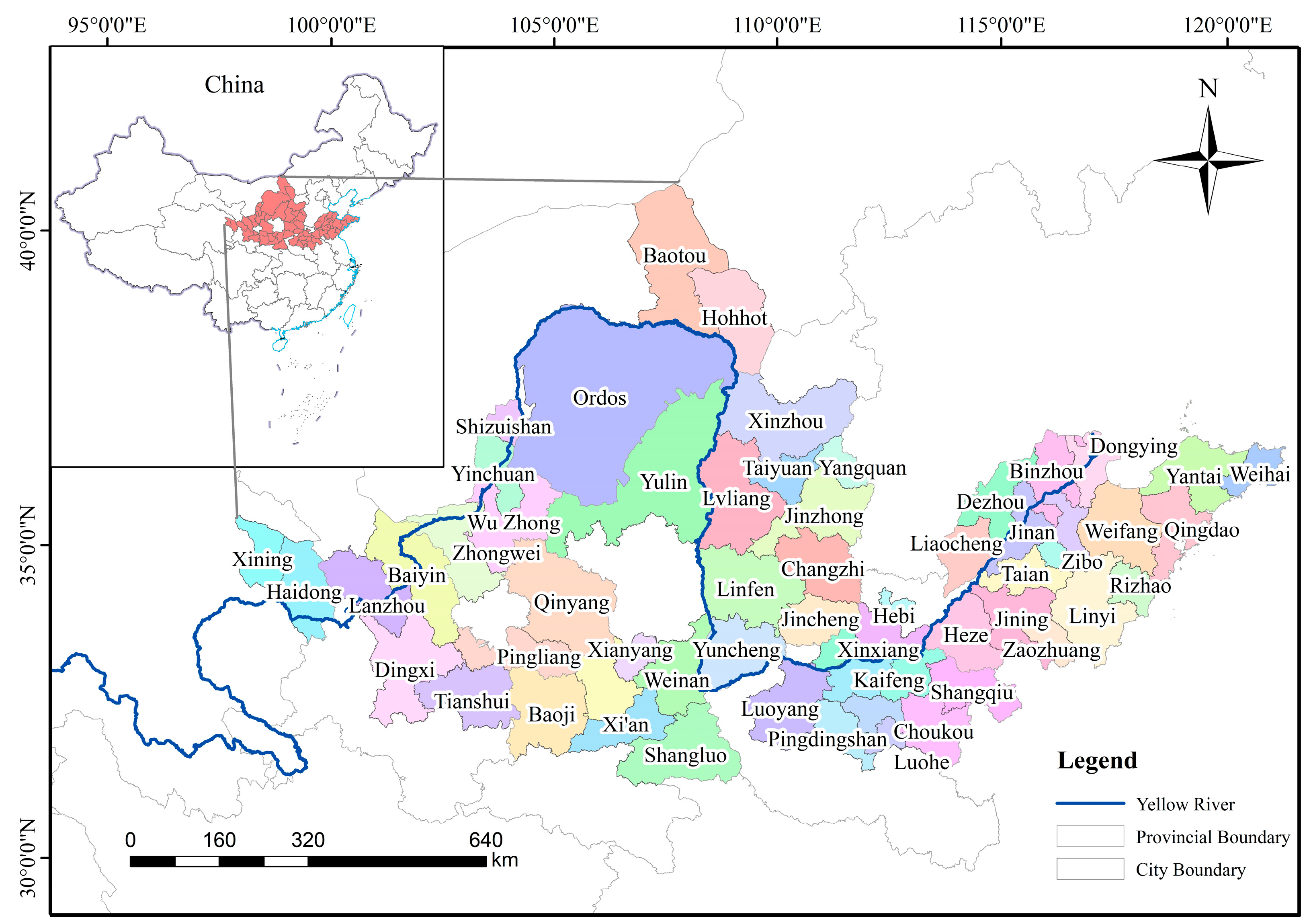
2.1. Study Area

The Yellow River flows from the Bayankara Mountains in the Qinghai–Tibet Plateau through several provinces and regions in China before emptying into the sea. The basin area covers 8.28% of China’s total national territory, which is 795,000 km2. There are 7 urban agglomerations in the Yellow River Basin, the urban agglomerations in the basin’s upper, middle, and lower reaches are divided based on locational conditions. Restricted by natural conditions, geographical location, and other conditions, the ecological level of the urban agglomeration in the river basin is characterized by “high head and tail, low in the middle”. According to the cities through which the Yellow River Basin flows, 59 major cities in the Yellow River Basin were identified, as shown in Figure 1.
The urban agglomerations in the Yellow River Basin cover approximately 618,800 km2, accounting for 27.2% of China’s national urban agglomeration in 2020, with a combined GDP of CNY (Chinese yuan) 24.74 trillion, accounting for a quarter of China’s national GDP. The population of this area was 435 million, accounting for 31.1% of the country’s total. Based on 2020 data, urban agglomerations concentrated more than 60% of the population in the Yellow River Basin. Grain production was 234 million tons; total meat production was 24.07 million tons; raw coal production was 3.078 billion tons; and natural gas production was 58.58 billion cubic meters, each of which accounted for 35.3%, 31.5%, 80%, and 33.3% of China’s total, respectively. The conflict between rapid economic development and resources is increasingly serious.

2.2. Theoretical Frameworks

Based on SDG 2 (elimination of hunger), SDG 6 (clean water and sanitation), SDG 11 (sustainable city), and SDG 15 (terrestrial life and realization of water environmental sustainability), this study constructed an evaluation index system, taking the evaluation of the land resources carrying capacity, water resources carrying capacity, and ecological resources carrying capacity as the main objects. It proposed the following theoretical framework: “land resources carrying capacity—water resources carrying capacity—ecological resources carrying capacity—comprehensive carrying capacity—warnings and attention partitions for dynamic monitoring—forecasting warning level”, establishing a “five-dimensional integration” model of the resource carrying capacity comprehensive evaluation for sustainable development. As a result, systematic integration of single-factor and resource-comprehensive carrying capacity was realized in support of sustainable development goals. This provides the basis for the sustainable development of the Yellow River Basin, as shown in Figure 2.

2.3. Methodology

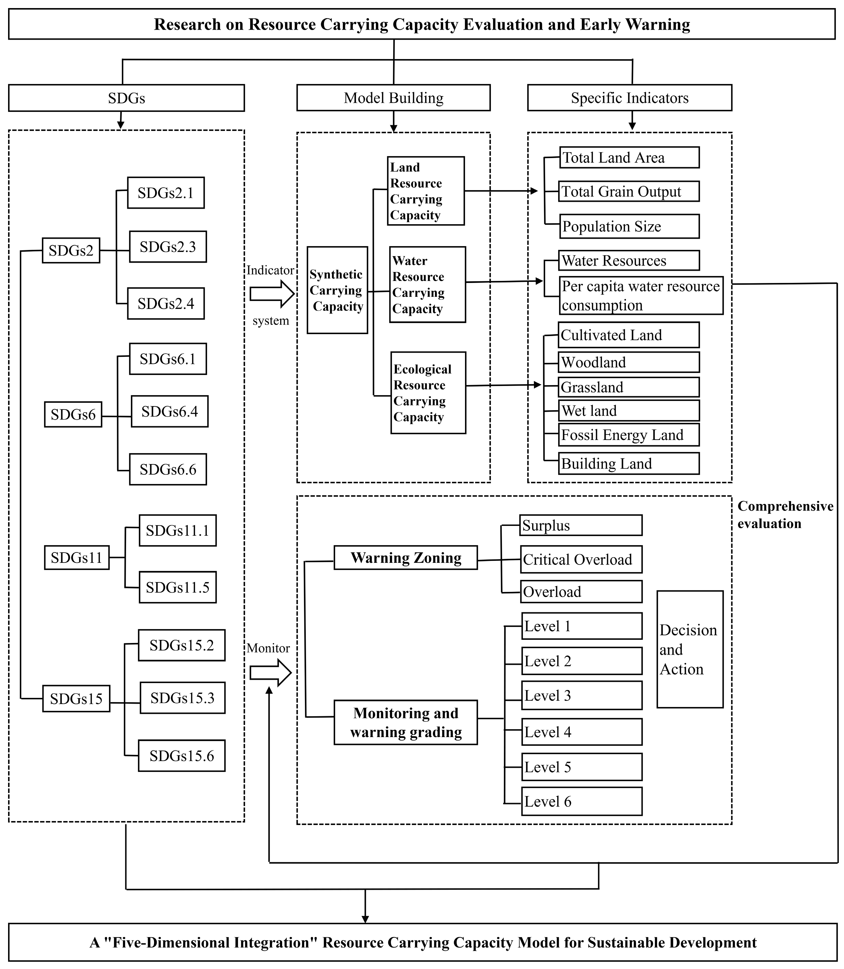
2.3.1. Comprehensive Resource Carrying Capacity Modeling

The comprehensive resource carrying index is a highly beneficial tool for evaluating the overall carrying capacity of a region’s soil, water, and ecology. It considers various factors, such as the carrying capacity of different types of land, including cultivated land for food, pastures for livestock, forest land for wood, and wetlands for fishery products. The index is calculated using Table 1, which considers the impact of construction land on cultivated land and energy consumption. Notably, fossil fuel land theoretically refers to land with CO2 dedicated to absorbing fossil fuel emissions, but in fact there is no land dedicated to this use, so fossil fuel land is valued at 0.
Among the natural systems of the Yellow River Basin, the land resources, water resources, and ecosystem elements are mutually constrained and jointly influence the ecological protection and high-quality development of the basin. Therefore, the land resources, water resources, and ecosystem elements have the same importance. The same weights are assigned to the carrying index for the weighted summation to obtain the comprehensive carrying index of the resources of the Yellow River Basin urban agglomeration. The formula to calculate the resource comprehensive carrying index is:
R = 1 3   ( L C C I + E C C I + E F C I )
where R is the comprehensive resource carrying index, LCCI is the land resource carrying index, ECCI is the water resource carrying index, EFCI is the ecological resources carrying index, and 1/3 is the weight value corresponding to the resource elements.

2.3.2. Resource Carrying Capacity Indicator System

Referring to the relevant literature domestically and abroad [28,29,30,31,36,37,38,39,40], based on the Sustainable Development Goals (SDGs), the indicators in the SDGs that are closely related to the carrying capacity of water, land, and ecological resources were selected, among which clean water and sanitation (SDG6) is related to the evaluation of the water resources carrying capacity, zero hunger (SDG2) is related to the evaluation of the carrying capacity of land resources, and the indicators in the SDGs for the sustainable development of cities and communities (SDG11) and sustainable terrestrial ecosystems (SDG15) are related to the evaluation of ecological resources carrying capacity. Therefore, 8 indicators and 23 specific indicators were selected from three aspects, namely, land resources, water resources, and ecological resources, which constitute the resource carrying capacity evaluation index system, as shown in Table 2.

2.3.3. Resource Carrying Capacity Warnings and Attention Partitions for Dynamic Monitoring Zoning

Referring to the relevant literature at the domestic level and abroad [3,18,19,20], according to the evaluation results of the land resources carrying index, water resources carrying index, and ecological resources carrying index, the resource carrying status is warnings, attention partitions, and dynamic monitoring grading, and the specific partitions and grading are shown in Table 3.

2.3.4. Resource Carrying Capacity Forecast Warning System

Referring to previous studies [3,5], the land resource, water resource, and ecological carrying capacities were listed (Table 4). Based on the carrying index, the resource carrying capacity was divided into three carrying status levels: surplus, critical overload, and overload; the corresponding status signals are green, blue, and red, respectively. The early warning grading system and monitoring index were constructed based on the “short board effect” principle, using the calculation results of different carrying states for different resource carrying capacities and carrying indices.

2.4. Data Resource

Data were predominantly obtained from the China Urban Statistical Yearbook (2020), provincial and municipal statistical yearbooks (2020), provincial and municipal water resources bulletins (2020), and land use data, which include county- and municipal-level major crop productions, cultivated areas, population, total water resources, water consumption, consumption data for major consumer products, and land use data. The land use data of the Yellow River Basin urban agglomeration (resolution is 30 m × 30 m) were obtained from the Resources and Environment Science and Data Center of the Chinese Academy of Sciences (https://www.resdc.cn/) in 2020, accessed on 1 October 2022.

3. Results

3.1. Resource Carrying Capacities and Indices of Urban Agglomeration in the Yellow River Basin

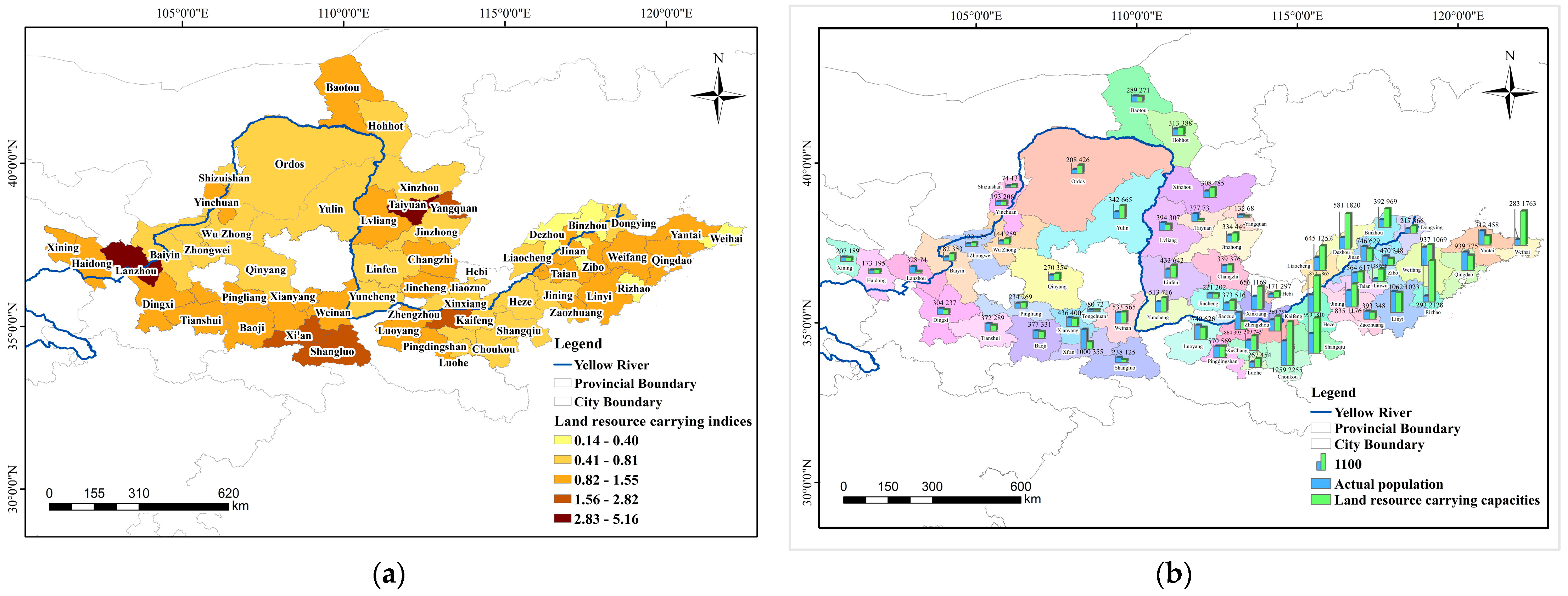
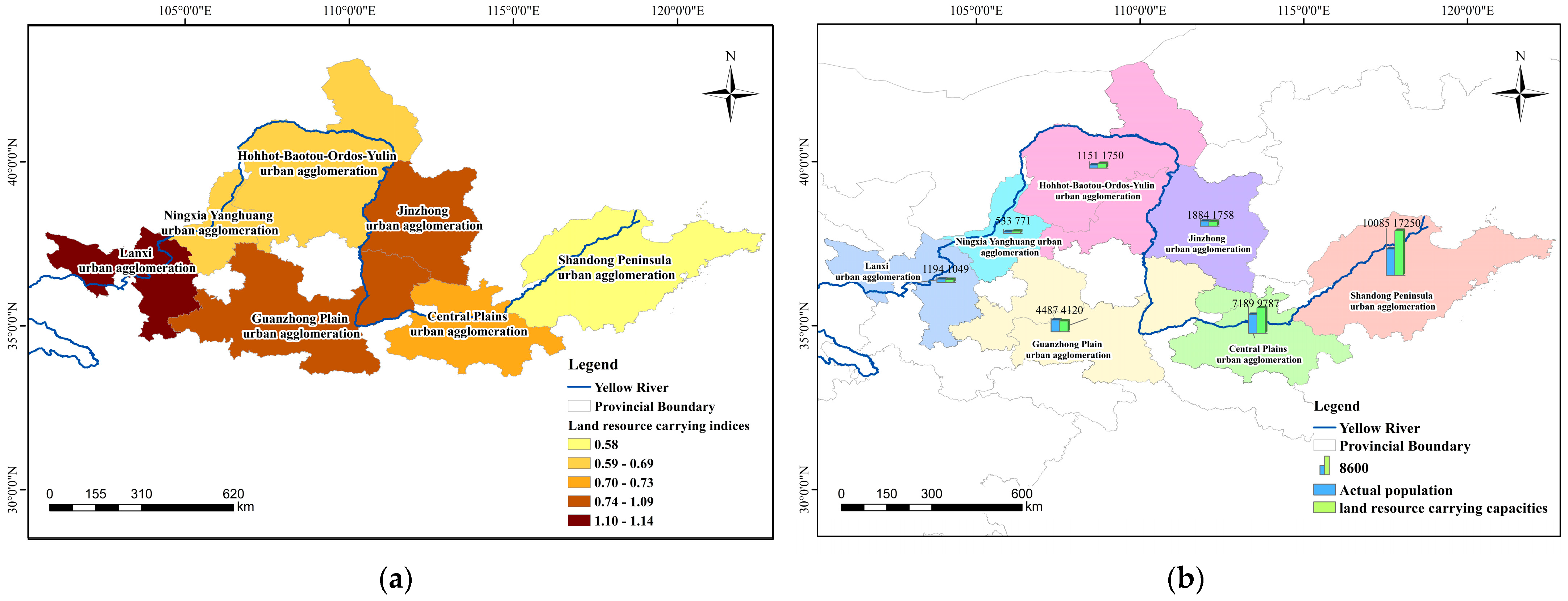
3.1.1. Land Resource Carrying Capacity

Urban agglomerations in the Yellow River Basin had surplus food, and no food shortage yet. The area’s carrying capacity of the land resources was 347.3557 million people, and the actual population was 253.717 million. The Shandong Peninsula had the largest carrying capacity at 172.5035 million people. Ningxia could carry 7.7073 million people, much more than the actual population. The populations of the Jinzhong, Guanzhong Plain, and Lanxi urban agglomerations were smaller than their actual populations. Lanxi had the smallest land resource carrying capacity at 10.4872 million people, with an actual population of 11.940 million, which means there was a severe shortage of land resources (Figure 3).
The urban agglomerations’ land resource carrying capacity indexes ranged from 0.58 to 1.14. Lanxi was overloaded, while Jinzhong and Guanzhong Plain were in a balanced surplus state. The other four urban agglomerations had surplus food. Based on the prefecture-level cities, the carrying capacity index ranged from 0.14 to 5.16, and 50.85% of the prefecture-level cities were in a food surplus state, including Rizhao, Weihai, Laiwu, Dezhou, Binzhou, Heze, Ordos, Liaocheng, Yulin, Baiyin city, Shangqiu, Wuzhong, Zhoukou, Xinxiang, Shizuishan, Hebi, Luohe, Dongying, Xinzhou, Linfen, Xuchang, Zhongwei city, Jining, Yuncheng, Jiaozuo, Jinzhong, Kaifeng, Qingyang, Hohhot, and Pingliang (Figure 3).
In total, 22% of the cities were in a balanced surplus state, including Weifang, Haidong city, Changzhi, Tai’an, Yinchuan, Weinan, Pingdingshan, Linyi, Baotou, Xianyang, Jincheng, Xining, and Tongchuan. In comparison, 15.25% were overloaded, including Zaozhuang, Baoji, Luoyang, Jinan, Qingdao, Dingxi city, Lvliang, Tianshui, and Zibo. Furthermore, 11.86% were seriously overloaded, including Yantai, Shangluo, Yangquan, Zhengzhou, Xi’an, Lanzhou, and Taiyuan. Taiyuan’s land resource carrying capacity index reached 5.16, reflecting the local land resources’ constraints on population growth (Figure 4).

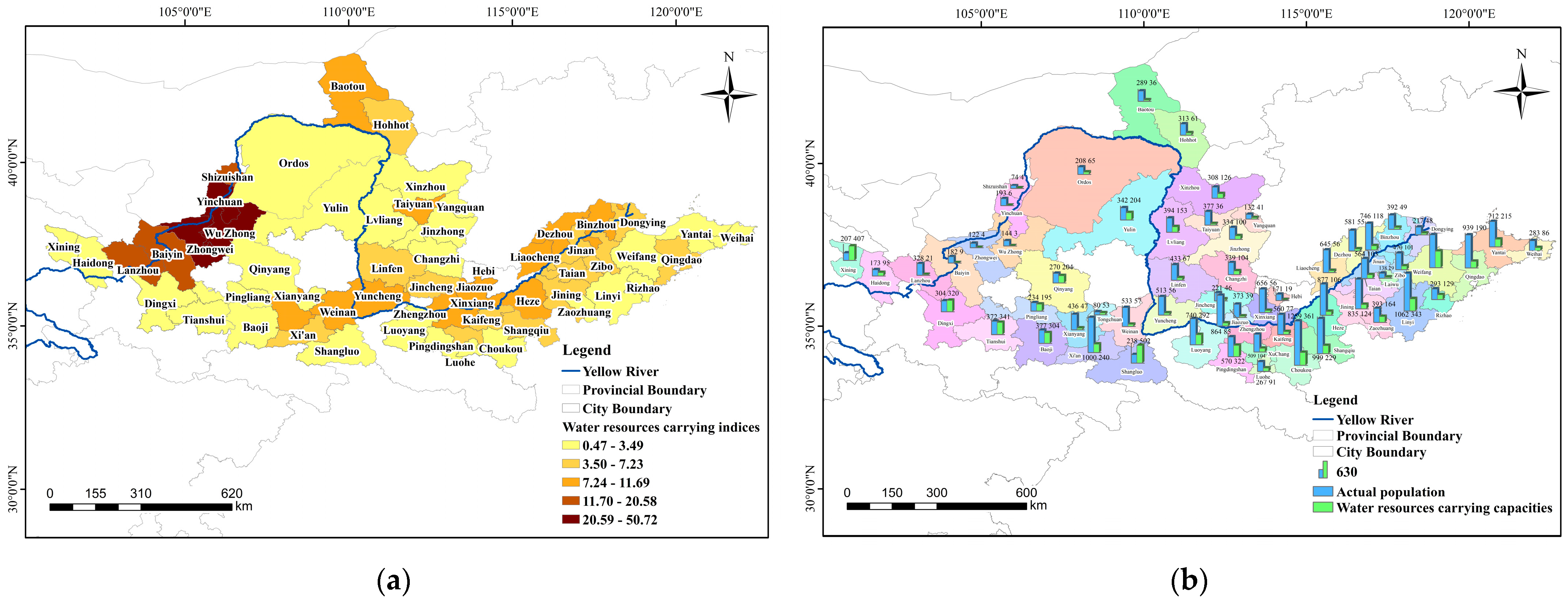
3.1.2. Water Resources Carrying Capacity

Water resources are scarce in the Yellow River Basin urban agglomeration. The water resources carrying capacities were much smaller than the actual population, and water resources, overall, were in deficit. The water resources carrying capacity of the population was 76,025,800, and the carrying index was >1.125. Only the Lanxi city group’s water resources were overloaded, whereas the other six urban agglomerations were in serious overload. The water resources carrying capacity index of the Ningxia urban agglomeration reached 30, with a severe shortage of water resources, highlighting the contradiction of the human–water relationship (Figure 5). The water resources carrying capacity index ranged from 0.47 to 50.72 for prefecture-level cities. Furthermore, 3.4% of these cities, including Shangluo and Xining, had surplus water resources, and 3.4% were in human–water balance, including Tianshui and Dingxi. Furthermore, 5.1% were overloaded, including Pingliang, Baoji, and Qingyang, and 88.1% of the cities were seriously overloaded, with Yinchuan, Wuzhong, and Zhongwei in the Ningxia urban agglomerations having water resources overload indices > 30 (Figure 6). Overall, the Yellow River Basin urban agglomerations were severely overloaded regarding water resources.

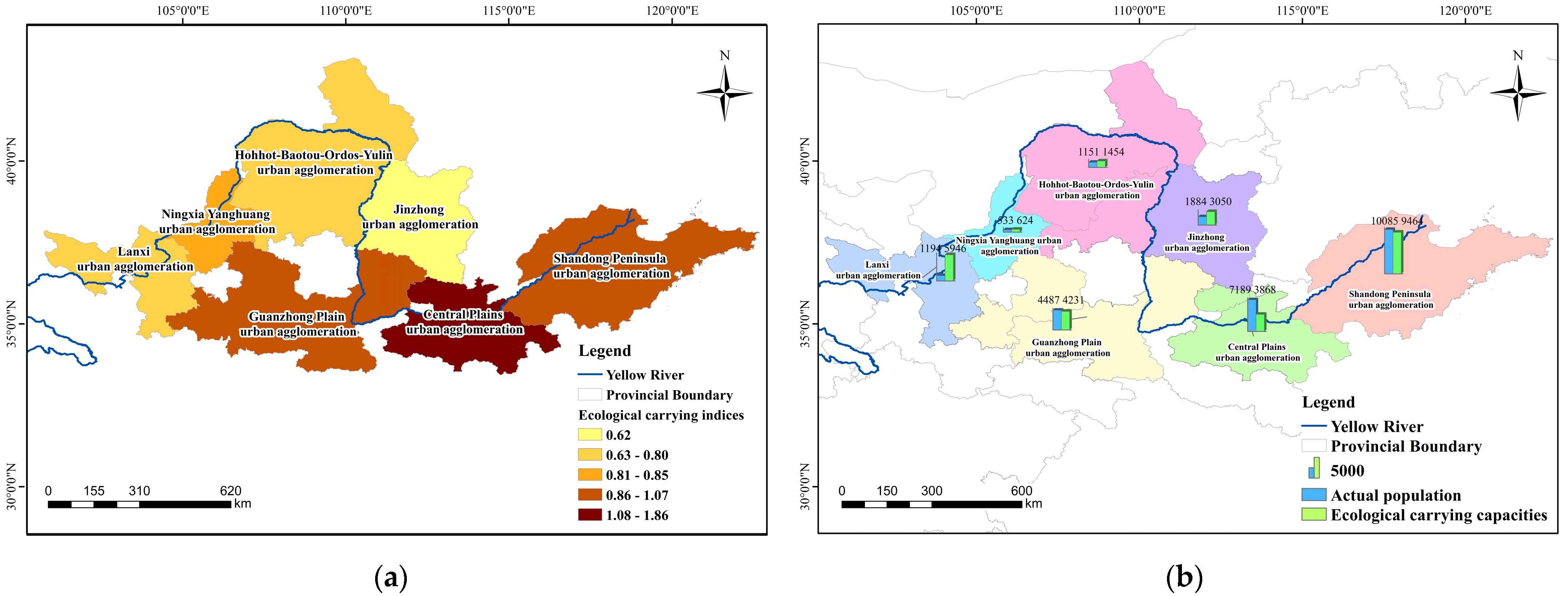
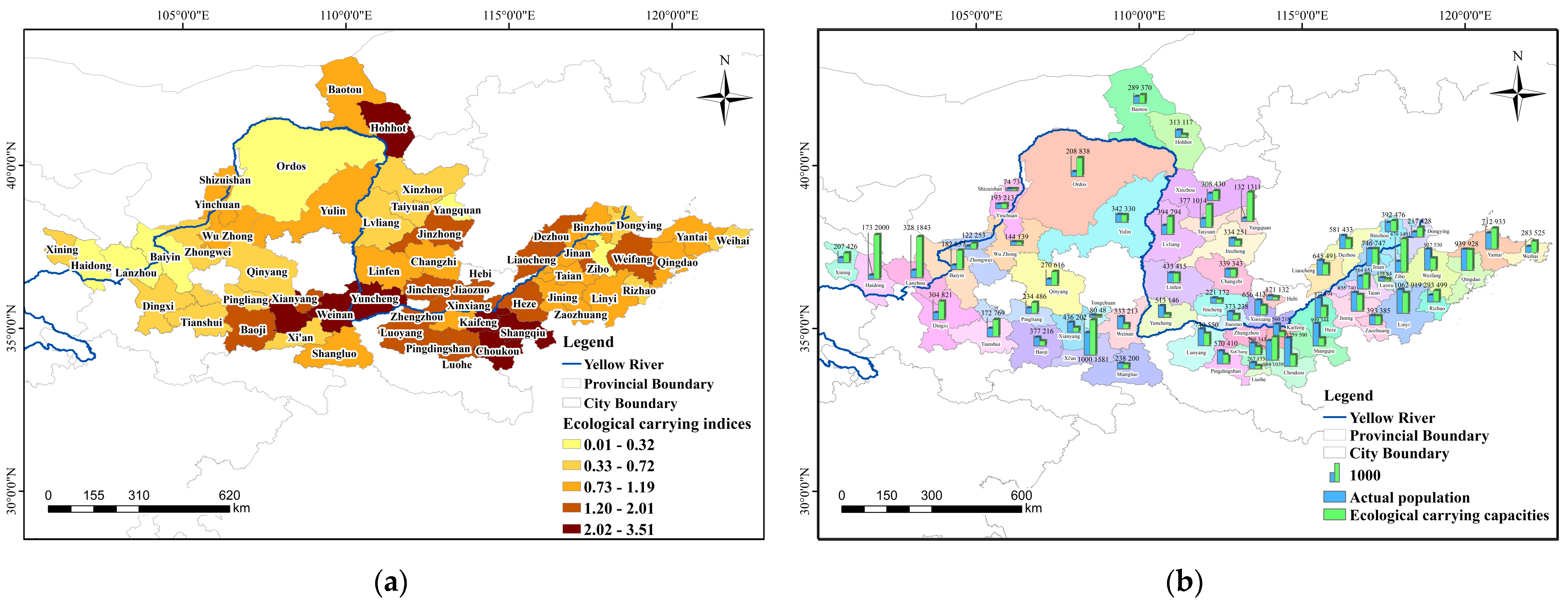
3.1.3. Ecological Carrying Capacity

The Yellow River Basin can support up to 486.58 million people but had 253.72 million people living there, with an average carrying index of 0.519, meaning it was in an ecologically prosperous state. The Lanxi urban agglomeration was in abundance and had a surplus with a carrying capacity of 0.046. The Jinzhong, Hohhot–Baotou–Ordos–Yulin, and Ningxia urban agglomerations were also in surplus. On the other hand, the Central Plains urban agglomeration had an ideal carrying capacity of 38.68 million people, but there were 71.89 million people in real situation, causing it to be in a seriously overloaded state. The Guanzhong Plain and Shandong Peninsula urban agglomerations were also in critically overloaded states (Figure 7).
Out of the cities analyzed, 40.7% were in ecological surplus states, including Haidong, Yangquan, Lanzhou, Baiyin, Ordos, Zibo, Dingxi, Taiyuan, Qingyang, Pingliang, Zhongwei, Tianshui, Xining, Luliang, Dongying, Weihai, Rizhao, Xi’an, Xinzhou, Yantai, Baotou, Binzhou, Zhengzhou, and Tai’an. While 15.26% of the cities were ecologically balanced, including Yinchuan, Changzhi, Jinan, Qingdao, Shizuishan, Zaozhuang, Yulin, Wuzhong, and Linfen. Of these, Qingdao, Shizuishan, Zaozhuang, Yulin, Wuzhong, and Linfen were in critical ecologically overloaded states. Furthermore, 44.7% of the cities were found to be in an ecological deficit state, including Jiaozuo, Xinxiang, Laiwu, Tongchuan, Baoji, Weifang, Heze, Luohe, Xianyang, Weinan, Zhoukou, Kaifeng, Hohhot, Shangqiu, and Yuncheng. Furthermore, 10.2 of the cities had carrying indices > 2.5 and were considered to be seriously overloaded, including Weinan, Zhoukou, Kaifeng, Hohhot, Shangqiu, and Yuncheng (Figure 8).

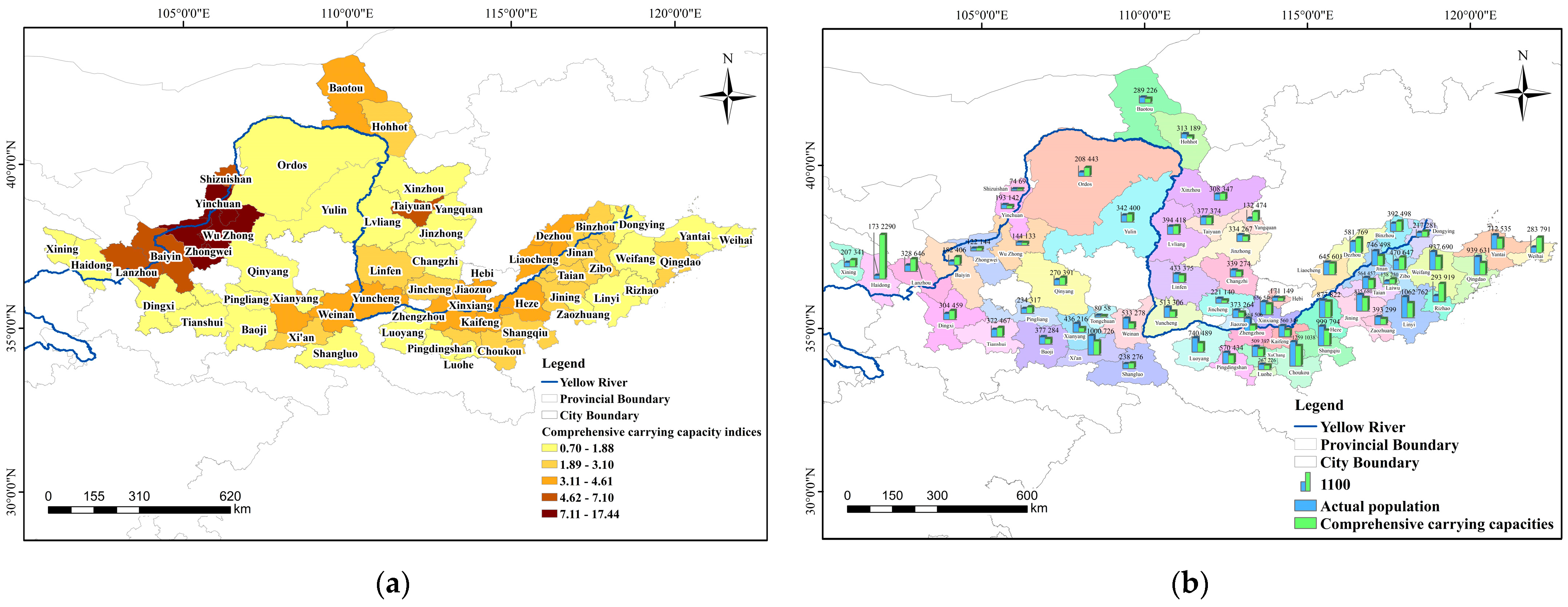
3.1.4. Comprehensive Resource Carrying Capacity

The comprehensive carrying capacity of the urban agglomerations in the Yellow River Basin was 304.06 million people, and the comprehensive carrying capacity index was 1.396. The Ningxia urban agglomeration had a population of 10.480, and resource pressure in this region is high. The comprehensive carrying capacity of the Lanxi urban agglomeration was 278.68 million people, and the comprehensive carrying capacity index was 0.866, which is a surplus state. The carrying capacity index of the Guanzhong Plain urban agglomeration was 1.119, which is a critically overloaded state, and the comprehensive carrying capacity index of the Hohhot–Baotou–Ordos–Yulin urban agglomeration was 1.294, which is an overloaded state. The comprehensive carrying capacities of the other four urban agglomerations were all greater than 1.5, which indicates that they were seriously overloaded (Figure 9). In terms of the comprehensive carrying capacity for each city’s resources, 76.3% of the cities had comprehensive carrying capacity indices > 1.125 and were, thus, in an overloaded state, while 8.5% of the cities were in a critical state, and 15.3% of cities had a comprehensive carrying capacity for resources in a surplus state (Figure 10).

3.2. Early Warning and Grading of Resource Carrying Capacity for Urban Agglomerations in the Yellow River Basin

Based on the assessment results of the resource carrying capacity monitoring indices of urban agglomerations in the Yellow River Basin, seven urban agglomerations and major cities were warned of their carrying status for land, water, and ecological resources (Table 5).
The comprehensive carrying capacities of the urban agglomerations in the Yellow River Basin were determined to be at level-three heavily overloaded states. Among them, the Ningxia and Hohhot–Baotou–Ordos–Yulin’s land and ecological carrying capacities were determined to be level-three heavily overloaded states, and water resources were their main limiting factor. The Jinzhong, Guanzhong Plain, and Shandong Peninsula were all determined to be level-two severely overloaded states, and water resources were the main limiting factor. The land resources of Jinzhong were also in a critical overloaded state, while the land and ecological resources of Guanzhong Plain were in a critically overloaded state, and the ecological resources of Shandong Peninsula were in a critically overloaded state. Both the Central Plains were determined to be in a level one severe load state, where the water and ecological resources of the important urban agglomerations are severely deficient, and the land and water resources of the Lanxi urban agglomeration are severely overloaded.
Among the three types of resource carrying capacities, the water resource carrying capacity was the main factor limiting the Yellow River Basin. The number of cities with an overloaded status for urban water resource carrying capacity was the largest, accounting for 56 of the 59 cities, and 94.9% had a red overloaded status. Furthermore, only 1.7% of the cities (one city) were considered to have a blue, critically overloaded status, and only 3.4% of the cities (two cities) had a water resource carrying capacity surplus status. For the ecological resources, 42.4% of the cities had a red overloaded status, 15.3% had a blue critical overload, and 40.7% had a green surplus. For the carrying capacity of land resources, 50.8% of the cities had a human–food surplus status, and 23.7% had a red overloaded status. Luoyang had all three resources in a red-overloaded state. There are 34 cities with two resources in a red overloaded status: Hohhot, Taiyuan, Yangquan, Lvliang, Baoji, Xi’an, Tongchuan, Weinan, Shangluo, Zhengzhou, Weifang, Laiwu, Heze, Dezhou, Linyi, Zibo, Luohe, Xianyang, Yuncheng, Luoyang, Shangqiu, Zhoukou, Xuchang, Jincheng, Jining, Lanzhou, Pingdingshan, Jinan, Qingdao, Kaifeng, Liaocheng, Hebi, Xinxiang, and Jiaozuo.
Overall, the Yellow River Basin urban agglomerations are resource constrained, negatively affecting resource consumption. In total, 67%, 22%, and 14% of the cities were determined to be in level one, two, and three severe load status, respectively, and only Xining was in level five light load status.

4. Discussion

The Yellow River is the second longest river in China and is known as China’s “Mother River” for its contribution to Chinese civilization. It is vital to human life and sustainable economic development in China and an important part of a high-quality development strategy, and the scale of socioeconomic development has to be compatible with the carrying capacity of the Yellow River Basin’s resources. In this study, the resource carrying capacity of urban agglomerations in the Yellow River Basin is evaluated through a comprehensive evaluation method, ecological footprint method, entropy weight method, and early warning system.
Some authors have also adopted the ecological footprint marking method to study the carrying capacity of regional ecological or water resources [3,4]. In the process of researching the resources and environment of sustainable development, through the principle of system dynamics or neural network modeling, ECCO (enhancement of carrying capacity options) dynamic modeling was established for various types of environmental resource elements with complex correlations to infer the resources and environment carrying capacity of the region in which they are located. Regarding the construction of the resource carrying capacity indicator system, the evaluation indicator system of this study selects the indicators closely related to the resource and environmental carrying capacity of the Yellow River Basin urban agglomerations in the United Nations Sustainable Development Goals (SDGs), which is consistent with the evaluation system of the water resources carrying capacity of the Heihe River Basin under the United Nations Sustainable Development Goals (SDGs) researched by Cheng Qingping [29]. Liu Rongzeng and other scholars constructed a comprehensive carrying capacity evaluation index system for the Yellow River Basin urban agglomerations from five aspects: economic factors, population factors, resource factors, ecological and environmental factors, and public service factors, focusing on the elements of the comprehensive carrying capacity of the urban agglomerations. This study integrates and innovates to construct a resource carrying capacity indicator system for the Yellow River Basin’s urban agglomerations based on sustainable development goals, water resources, land resources, and ecological resources, which provides a paradigm for the study of the resource carrying capacity of urban agglomerations in large river basins and, at the same time, provides a scientific basis for advancing the efficiency of the inter-regional allocation of resources in the Yellow River Basin’s urban agglomerations and enhancing the capacity of the environmental carrying capacity.
The resource and environmental carrying capacity were mainly divided according to administrative, geographic, and economic regions. An evaluation of the regional resource and environmental carrying capacity was carried out at three levels: macroscale (referring to global, national, transregional, etc.), mesoscale (referring to urban agglomerations, second-level watersheds, provinces, etc.), and microscale (referring to municipalities, counties, industrial parks, etc.). Studies have been carried out at the scale of urban agglomerations, including the Chang–Zhu–Tan urban agglomeration [15]. Studies at the scale of the watershed area include an evaluation of the water resources carrying capacity of the Yellow River Basin [23,24], a noncoordinated coupling evaluation of a new type of urbanization and the ecological carrying capacity of the Yellow River Basin [41], a spatial resource and environmental carrying capacity and suitability assessment of the Yellow River Basin [42], the Bohai Rim Beach carrying capacity and suitability evaluation [43], an evaluation of the carrying capacity of the production–living–ecological space of the arid areas of the lower Tarim River [44], the carrying capacity of the resource environment of the Wujiang River Basin [45], the carrying capacity of the Krueng Langsa River Basin [46], etc. In this study, a comprehensive evaluation of the carrying capacity was carried out at three scales, namely, the Yellow River Basin regional scale, the city agglomeration mesoscale, and the city microscale, which integrated and innovated the methodological system of watershed-scale research and enriched the carrying capacity research system at the watershed scale, the city agglomeration scale, and the city scale.
According to the water resources carrying capacity results, this study shows that the Yellow River Basin urban agglomeration’s water resources are in short supply. The water resources carrying capacities are much smaller than the actual populations, the water resources carrying capacity index of the Ningxia urban agglomeration is 30, which is seriously insufficient, and the human–water relationship is prominently contradictory, which is basically in line with the results of the study on the spatial and temporal dynamics of the water resources carrying capacity of the Yellow River Basin of He Mengwei [7] that found that the water resources carrying capacities in Ningxia and Inner Mongolia were in critical states. A study on the water resources carrying capacity in the Yellow River Basin by Zhang Ningning [47] showed that the water resources carrying capacity was overloaded. Overall, the water resources carrying capacities of the Yellow River Basin urban agglomerations were overloaded, which is consistent with the results of the water resources carrying research on the cities concerned in this study. This result indicates that the urban agglomerations of the Yellow River Basin still need to improve their water resources carrying capacity, optimize the allocation according to each city’s actual situation, and develop water-saving technologies.
From the results of the ecological resources carrying capacity, this study shows that the ecological carrying capacity of the Yellow River Basin was 486.58 million people, and the actual population was 253.72 million people, with an average carrying index of 0.519, which is an ecological affluent state. The ecological carrying capacity of the Lanxi urban agglomeration was in a state of richness and abundance, while the Jinzhong urban agglomeration, Hohhot–Baotou–Ordos–Yulin urban agglomeration and Ningxia urban agglomeration were in a surplus state. The Central Plains urban agglomeration was in a severely overloaded state. The Guanzhong Plain urban agglomeration and Shandong Peninsula urban agglomeration ere in a critically overloaded state, which is basically in line with the conclusion of Zhao Jingfeng [48], who found that Ordos ranked first in a coordinated development index on a study of the ecological carrying capacity of seven urban agglomerations in the Yellow River Basin. The results of his study also indicate that the ecological carrying capacity of the Yellow River Basin was relatively balanced. In contrast, the conclusions of the present study show that 15.26% of the cities in the urban agglomerations of the Yellow River Basin were in an ecologically balanced state, which may be due to the inconsistency of the scope of the study area, resulting in some controversial conclusions.
According to the results of the land resources carrying capacities, this study shows that the population–food–land of the urban agglomerations of the Yellow River Basin was in food surplus. A human–food contradiction was not yet prominent, and this result shows that Shizuishan’s ecological carrying capacity was less than Yinchuan’s ecological carrying capacity, as exemplified by the study of the city agglomerations along the Yellow River in Ningxia conducted by Wang Yajuan et al. [49]. This result is the same as derived from this paper showing that Shizuishan’s ecological carrying capacity was less than Yinchuan. The results of Zhou Luhong’s [50] study on the land resources carrying capacity of Shaanxi Province show that the land resources carrying capacity of Xi’an and Yulin were relatively high and also consistent with the results of this paper, and, at present, there are fewer systematic studies on the land resources carrying capacity of the Yellow River Basin’s urban agglomerations, and this study carried out a relatively more comprehensive study on the land resources carrying capacity of the Yellow River Basin urban agglomerations.
Considering the comprehensive evaluation results, this study shows that the Guanzhong Plain urban agglomeration and Lanxi urban agglomeration had lower carrying indexes, and the Ningxia urban agglomeration and Central Plain urban agglomeration had higher carrying indexes, which is slightly different from the results of the study by Liu Rongzeng et al. [4]. There are two reasons for this analysis: First, the former used land–water–ecological resources for its evaluation, while the latter used economy–population–ecological environment–resources–public service facilities for its evaluation, and a difference in indicator systems leads to different comprehensive evaluation results. The second is the difference in research methods, with the former using a combination of the ecological footprint method and entropy weight method to calculate with the latter using the factor analysis method, which impacts the evaluation results.
The results for the resource carrying early warnings for the Yellow River Basin’s urban agglomerations show that the water resources carrying capacity was the main factor limiting the resource carrying capacity of the Yellow River Basin, which is consistent with Lu Yali et al. [24]. It shows that the Yellow River Basin’s urban agglomerations suffer from serious water shortage and uneven spatial and temporal distribution, and they need to improve further the water resources carrying conditions and utilization efficiencies. In addition, this study also found that early warning studies based on SDGs can effectively identify and predict risks to resource carrying capacity, and this study supports the vital role of SDGs in resource and environmental management. Therefore, this study’s early warning model can help decision-makers promptly understand the status of the resource carrying capacity so that adequate policies and measures can be formulated.
Overall, this study emphasizes the important role of resource carrying capacity in the sustainable development of the Yellow River Basin’s urban agglomerations, and the results reveal the complexity of the resource carrying capacity, which needs to further be explored in future studies. However, there are some limitations to our study. The results of this study are consistent with previous studies but only consider water resources, land resources, and ecological resources, and it lacks a more comprehensive evaluation of the natural environment, social economy, and environmental pollution in the Yellow River Basin. Therefore, we need more research to more accurately predict and manage risks to resource carrying capacity.

5. Conclusions

(1)
Based on the sustainable development goal, establishing a “five-dimensional integrated” resource comprehensive carrying capacity evaluation model, this study established a monitoring and early warning system based on sustainable development. It adopted comprehensive and integrated methods, such as the index system method, entropy weight method, geographic information system, and statistical analysis, to construct a theoretical and methodological system, as well as to carry out systematic analysis and research on the alert zoning and early warning grading of the Yellow River Basin’s urban agglomerations. The model’s construction and the framework of this study can aid in monitoring the resource carrying status of the Yellow River Basin and provide scientific support for the ecological protection and high-quality development of the Yellow River Basin, as well as provide a research paradigm for the world’s largest river basin and the sustainable development of man and nature in the world.
(2)
The comprehensive carrying capacity of the Yellow River Basin urban agglomerations is in an overloaded state, of which the water resources carrying capacity is in a state of deficit, the population–food–land is in a state of food surplus, and the ecological carrying capacity is in a state of ecological affluence. The integrated resource carrying capacities of the cities in the Yellow River Basin urban agglomeration have obvious spatial differentiation. From west to east, the land and water resources carrying indexes show a downward trend. The water and soil resources pressure in the eastern part of the Yellow River Basin is small. It is necessary to optimize this further to improve the comprehensive carrying capacity of the Yellow River Basin urban agglomeration.
(3)
The Yellow River Basin urban agglomerations are in a level-three heavily overloaded state; the negative impacts of resource consumption are more extensive. More cities are in a level-one severely overloaded state, and measures need to be taken to improve the resource carrying capacity. The carrying capacity of water resources is the main factor limiting of the resource carrying capacity of the Yellow River Basin.
(4)
The disadvantage of this study is that the carrying capacity index system needs to be further developed, and the accuracy needs to be higher. It is suggested to add environmental, social, economic, information technology, and digital economy indicators; a resource and environmental carrying capacity assessment system based on high score image researched and developed; dynamic monitoring of resource and environmental carrying capacity implemented in the future; and scientific basis for sustainable development goals more accurately provided.
(5)
This study provides scientific support and research paradigm for high-quality research in the world’s river basins, including the Yellow River Basin. It is of great significance to the harmonious coexistence between human beings and nature and the construction of ecological civilization.

Author Contributions

Conceptualization, X.B.; methodology, X.B.; software, X.W.; formal analysis, X.W.; investigation, X.W.; resources, X.B. and X.W.; data curation, X.B. and X.W.; writing—original draft preparation, X.W., G.S. and J.W.; writing—review and editing, X.W., G.S. and J.W.; visualization, X.W.; supervision, X.W., G.S. and J.W.; funding acquisition, X.B. All authors have read and agreed to the published version of the manuscript.

Funding

This research was supported by the “Ningxia Key Research and Development Project” (2022CMG03055) and the “National Science and Technology Basic Resources Survey Special Project”(2022FY101904-3).

Institutional Review Board Statement

Not applicable.

Informed Consent Statement

Not applicable.

Data Availability Statement

All data published in this manuscript are available upon request to the authors.

Conflicts of Interest

The authors declare no conflict of interest.

References

  1. Feng, C.; Yang, Y.Z.; Yan, H.M.; Yan, H.M.; Pan, T.; Li, P. A century of research on resource and environmental carrying capacity: From theory to practice. Resour. Sci. 2017, 39, 379–395. [Google Scholar]
  2. Feng, C.; You, Z.; Yang, Y.Z.; Shi, H. Comprehensive evaluation of Tibet’s resource and environmental carrying capacity based on three-dimensional tetrahedral model. J. Geogr. 2021, 76, 645–662. [Google Scholar]
  3. Liu, Y.J.; Dai, L.; Zhang, J.; Feng, Z.M.; Pan, T.; Ge, Q.S. Research on Monitoring Resource Carrying Capacity: Taking Three-Rivers Region in Tibet as an Example. J. Nat. Resour. 2020, 35, 1699–1713. [Google Scholar]
  4. Liu, R.Z.; Wang, Y.B.; He, C. Study on the comprehensive carrying capacity of urban agglomerations in the Yellow River basin from the perspective of high-quality development. Ecol. Econ. 2022, 38, 89–97. [Google Scholar]
  5. Ye, Y.H.; Han, Z.; Sun, F.F.; Zhang, Y.; Huang, T.; Chen, L.; Li, X. Research on early warning evaluation of small-scale resource and environmental carrying capacity—Taking Dapeng Peninsula as an example. J. Ecol. Environ. 2017, 26, 1275–1283. [Google Scholar]
  6. Hu, H.; Han, L. Evaluation of Land Carrying Capacity of 31 Provinces in China Based on a Natural–Societal-Supply–Demand Framework. Sustainability 2023, 15, 1037. [Google Scholar] [CrossRef]
  7. He, M.W.; Yang, X.L. Study on the spatiotemporal dynamics of water resources carrying capacity in the Yellow River Basin from 2010 to 2019. Water Resour. Sci. Cold Reg. Eng. 2022, 5, 59–63. [Google Scholar]
  8. Wang, J.Y.; Mu, X.Q.; Chen, S.J.; Liu, W.; Wang, Z.; Dong, Z.F. Dynamic evaluation of water resources carrying capacity of the Dianchi Lake Basin in 2005–2015, based on DSPERM framework model and simulated annealing-projection pursuit model. Reg. Sustain. 2021, 2, 189–201. [Google Scholar] [CrossRef]
  9. Zhang, T.; Hu, Q.N.; Zhou, D.; Gao, W.J.; Fukuda, H. Ecological carrying capacity evaluation for villages’ spatial planning in rural revitalization strategy in gully regions of the Loess Plateau (China). J. Asian Archit. Build. Eng. 2023, 22, 1746–1762. [Google Scholar] [CrossRef]
  10. Ci, X.; Zhang, L.; Wang, T.; Xiao, Y.; Xia, J. Research on the ECC of Chengdu–Chongqing’s Urban Agglomeration in China Based on System Dynamics. Sustainability 2022, 14, 10896. [Google Scholar] [CrossRef]
  11. Yu, W.; Tao, T. Scenario Simulation for the Urban Carrying Capacity Based on System Dynamics Model in Shanghai, China. Sustainability 2022, 14, 12910. [Google Scholar] [CrossRef]
  12. Guo, Q.; Wang, J.Y.; Zhang, B. Comprehensive evaluation of regional water resources carrying capacity based on DPSIRM framework. J. Nat. Resour. 2017, 32, 484–493. [Google Scholar]
  13. Wang, J.; Sun, T.H.; Li, P.J.; Hou, W. A regional water environment carrying capacity evaluation model based on artificial neural network and its application. J. Ecol. 2007, 26, 139–144. [Google Scholar]
  14. Tang, Y.Z.; Wang, M.D.; Liu, Q.; Hu, Z.W.; Zhang, J.; Shi, T.Z.; Wu, G.F.; Su, F.Z. Ecological carrying capacity and sustainability assessment for coastal zones: A novel framework based on spatial scene and three-dimensional ecological footprint model. Ecol. Model. 2022, 466, 109881. [Google Scholar]
  15. Wang, Q.; Li, W. Research progress and outlook of regional resource and environmental carrying capacity evaluation. J. Ecol. Environ. 2020, 29, 1487–1498. [Google Scholar]
  16. Tang, K.; Tang, C.L.; Zhao, T.T. Evaluation of resource Carrying capacity of Changzhutan based on set pair analysis. Land Resour. Sci. Technol. Manag. 2012, 29, 46–53. [Google Scholar]
  17. Yang, F.; Chen, Z.M.; Gong, S.B. Evaluation of Land Carrying Capacity of Various Cities in Liaoning Province Based on AHP Entropy Weight TOPSIS Model. Soil Water Conserv. Bull. 2022, 42, 144–149. [Google Scholar]
  18. Xiong, J.X.; Wang, X.B.; Zhao, D.; Wang, J. Spatiotemporal evolution for early warning of ecological carrying capacity during the urbanization process in the Dongting Lake area, China. Ecol. Inform. 2023, 75, 102071. [Google Scholar] [CrossRef]
  19. Li, Y.X.; Xue, D.Q.; Song, Y.Y. Early warning of spatial and temporal changes and trends of Water resources of China carrying capacity. Resour. Environ. Yangtze River Basin 2021, 30, 1574–1584. [Google Scholar]
  20. Li, X.; Guri, A.; Yu, T.; Yin, H.M.; Tu, H.Y. Spatial and temporal dynamic monitoring and driver factor analysis of ecological carrying capacity in 5 Central Asian countries. J. Univ. Chin. Acad. Sci. 2023, 40, 474–485. [Google Scholar]
  21. Guo, L.S.; Zhu, W.B.; Wei, J.X.; Wang, L.F. Water demand forecasting and countermeasures across the Yellow River basin: Analysis from the perspective of water resources carrying capacity. J. Hydrol. Reg. Stud. 2022, 42, 101148. [Google Scholar]
  22. Qiao, R.; Li, H.; Han, H. Spatio-Temporal Coupling Coordination Analysis between Urbanization and Water Resource Carrying Capacity of the Provinces in the Yellow River Basin, China. Water 2021, 13, 376. [Google Scholar] [CrossRef]
  23. Chen, X.H.; Qian, X. Evaluation of the Comprehensive Carrying Capacity of Urban Agglomeration in the Yangtze River Ecological and Economic Zone. Stat. Decis. Mak. 2019, 35, 64–66. [Google Scholar]
  24. Lu, Y.L.; Xu, S.S.; Si, B.J.; Shen, L. Study on dynamic evolution characteristics of Carrying capacity of water resources in nine provinces (regions) of the Yellow River basin. People’s Yellow River 2021, 43, 103–108. [Google Scholar]
  25. Tang, J.K.; Ding, W.G.; Li, W.L.; Liu, X.D. Evaluation of Water Resources Carrying Capacity and Research on Obstacle Factors in the Yellow River Basin. People’s Yellow River 2021, 43, 73–77. [Google Scholar]
  26. Wang, Y.; Lei, S.Z. Study on Evaluation of Carrying capacity of Resources in the Yellow River Basin. People’s Yellow River 2022, 44, 17–21+33. [Google Scholar]
  27. Li, Y.X.; Cao, M.Y. Study on the spatiotemporal evolution and influencing factors of urban comprehensive carrying capacity in the Yellow River Basin. Ecol. Econ. 2022, 38, 72–81+88. [Google Scholar]
  28. Zhao, Y.Q.; Dai, R.K.; Yang, Y.; Li, F.; Zhang, Y.; Wang, X.Y. Integrated evaluation of resource and environmental carrying capacity during the transformation of resource-exhausted cities based on Euclidean distance and a Gray-TOPSIS model: A case study of Jiaozuo City, China. Ecol. Indic. 2022, 142, 109282. [Google Scholar] [CrossRef]
  29. Wang, W.L.; Liu, T.; Luo, G.P. Evaluation of water Carrying capacity in Kyrgyzstan based on Sustainable Development Goals. Arid Zone Res. 2022, 39, 1801–1809. [Google Scholar]
  30. Cheng, Q.P.; Zhong, F.L.; Zuo, X.A.; Yang, C.L. Evaluation of the Water Resources Carrying Capacity of the Heihe River Basin in the Combination of Beautiful China and the United Nations Sustainable Development Goals. China Desert 2020, 40, 204–214. [Google Scholar]
  31. Wu, C.; Jiang, A.D.; Zheng, W. Study on the Measures for Optimizing China’s Provincial Territorial Space Based on the Perspective of Resource and Environmental Carrying Capacity in the New Situation. Sustainability 2022, 14, 13754. [Google Scholar] [CrossRef]
  32. Dong, X.; Gao, S.; Xu, A.; Luo, Z.; Hu, B. Research on Tourism Carrying Capacity and the Coupling Coordination Relationships between Its Influencing Factors: A Case Study of China. Sustainability 2022, 14, 15124. [Google Scholar] [CrossRef]
  33. Zhang, Z.; Hu, B.Q.; Qiu, H.H. Comprehensive evaluation of resource and environmental carrying capacity based on SDGs perspective and Three-dimensional Balance Model. Ecol. Indic. 2022, 138, 108788. [Google Scholar] [CrossRef]
  34. Yu, F.W.; Fang, L. Several issues concerning ecological protection and high-quality Development in the Yellow River Basin. China Soft Sci. 2020, 6, 85–95. [Google Scholar]
  35. Deng, X.Z.; Yang, K.Z.; Dan, J.J.; Dong, S.C.; Zhang, W.G.; Guo, R.X.; Tan, M.H.; Zhao, P.J.; Li, Y.; Miao, C.H.; et al. Urban Agglomeration and Industrial Transformation and Development in the Yellow River Basin. J. Nat. Resour. 2021, 36, 273–289. [Google Scholar] [CrossRef]
  36. Feng, Z.M. The Past, Present, and Future of Land Carrying Capacity Research. China Land Sci. 1994, 3, 1–9. [Google Scholar]
  37. Zhao, J.; Wang, Y.; Zhao, C.Z.; Jin, M.Z. Study on Ecological footprint and carrying capacity dynamics of water resources in Yanbian Prefecture. J. China Agric. Univ. 2017, 22, 74–82. [Google Scholar]
  38. Chen, Z.J.; Tang, D.Y. A Study on the Sustainable Utilization of Urban Water Resources Using the Water Resource Footprint Model: A Case Study of Nanjing City. China Rural Water Resour. Hydropower 2015, 389, 25–28. [Google Scholar]
  39. Zhao, X.G.; Xiao, L.; Lan, Y.X.; Wang, S.Z.; Ma, C.H. Study on the dynamic of Ecological footprint and ecological carrying capacity in Shaanxi Province. China Agric. Sci. 2005, 4, 746–753. [Google Scholar] [CrossRef]
  40. Liu, D.; Feng, Z.M.; Yang, Y.Z. Analysis of supply and demand balance of China’s ecological carrying capacity based on Ecological footprint. J. Nat. Resour. 2012, 27, 614–624. [Google Scholar]
  41. Zhang, D.; Zhu, L.; Ma, X.; Liu, Z.; Cui, H. Uncoordinated Coupling Assessment of New Urbanization and Ecological Carrying Capacity in the Yellow River Basin. Int. J. Environ. Res. Public Health 2022, 19, 9016. [Google Scholar] [CrossRef] [PubMed]
  42. Chen, Y.; Liu, S.; Ma, W.; Zhou, Q. Assessment of the Carrying Capacity and Suitability of Spatial Resources and the Environment and Diagnosis of Obstacle Factors in the Yellow River Basin. Int. J. Environ. Res. Public Health 2023, 20, 3496. [Google Scholar] [CrossRef] [PubMed]
  43. Xu, H.J.; Jia, A.; Song, X.L.; Bai, Y.C. Suitability evaluation of carrying capacity and utilization patterns on tidal flats of Bohai Rim in China. J. Environ. Manag. 2022, 319, 115688. [Google Scholar] [CrossRef] [PubMed]
  44. Fang, C.L.; Bao, C.; Zhang, C.G. Scenario analysis on the Change Situation and Evolution of Ecological Production Life Carrying Capacity in Arid Areas. J. Ecol. 2003, 9, 1915–1923. [Google Scholar]
  45. Wang, D.H.; Li, X.D. Analysis of Carrying capacity of mountain basin resources and regional coordinated development: Taking Wujiang River basin in Guizhou as an example. Environ. Sci. Technol. 2019, 42, 222–229. [Google Scholar]
  46. Fauzia, A. Analysis of the carrying capacity of the krueng langsa river basin based on the water management criteria. IOP Conference Series. Earth Environ. Sci. 2023, 1182, 012043. [Google Scholar]
  47. Zhang, N.N.; Su, X.L.; Zhou, Y.Z.; Niu, J.P. Evaluation of Water Resources Carrying Capacity in the Yellow River Basin. J. Nat. Resour. 2019, 34, 1759–1770. [Google Scholar]
  48. Zhao, J.F.; Li, Y. Evaluation and spatiotemporal differentiation evolution of the comprehensive carrying capacity of urban agglomerations in the Yellow River Basin. Ecol. Econ. 2022, 38, 75–83. [Google Scholar]
  49. Wang, Y.J.; Mi, W.B. Study on the Ecological Carrying capacity of the Urban Belt along the Yellow River in Ningxia. Resour. Environ. Arid Areas 2010, 24, 23–27. [Google Scholar]
  50. Zhou, L.H.; Cao, R.C.; Wang, P.T. Evaluation of Agricultural Production Suitability Based on Land Resource Carrying Capacity: Taking Shaanxi Province as an Example. Ecol. Econ. 2022, 38, 125–130. [Google Scholar]
Figure 1. Distribution map of the urban agglomerations in the Yellow River Basin, China.
Sustainability 15 14577 g001
Figure 2. The theoretical framework of the “five-dimensional integration” evaluation of the resource carrying capacity with the goal of sustainable development.
Sustainability 15 14577 g002
Figure 3. Land resource carrying indices (a) and land resource carrying capacities (b) in the Yellow River Basin, China.
Sustainability 15 14577 g003
Figure 4. Land resource carrying indices (a) and land resource carrying capacities (b) for the major cities in the urban agglomeration of the Yellow River Basin, China.
Sustainability 15 14577 g004
Figure 5. Water resources carrying indices (a) and water resources carrying capacities (b) for the Yellow River Basin, China.
Sustainability 15 14577 g005
Figure 6. Water resources carrying indices (a) and water resources carrying capacities (b) for the major cities in the urban agglomeration of the Yellow River Basin, China.
Sustainability 15 14577 g006
Figure 7. Ecological carrying indices (a) and ecological carrying capacities (b) in the Yellow River Basin, China.
Sustainability 15 14577 g007
Figure 8. Ecological carrying indices (a) and ecological carrying capacities (b) for the major cities in the urban agglomeration of the Yellow River Basin, China.
Sustainability 15 14577 g008
Figure 9. Comprehensive carrying capacity indices (a) and comprehensive carrying capacities (b) for the Yellow River Basin, China.
Sustainability 15 14577 g009
Figure 10. Comprehensive carrying capacity indices (a) and comprehensive carrying capacities (b) for the major cities in the urban agglomeration of the Yellow River Basin, China.
Sustainability 15 14577 g010
Table 1. Model calculation methods.
Type of Resource Carrying CapacityCalculation MethodFormulaNotesReference Sources
Land resources carrying capacityLand resources carrying capacity model L C C = G / G p LCC is the land resources carrying capacity (person); G is the total food production (kg); Gp is the per capita food consumption standard (kg/person), and the reference value is 400 kg/person.Feng, Z.M., et al. [36]
Land resource carrying index model L C C I = P a / L C C LCCI is the land resource carrying index; Pa is the actual population of the region (people).
Water resources carrying capacityWater resources carrying capacity model     E C = 0.4 γ ϕ Q w / P w EC is the water resources’ ecological carrying capacity (hm2); 0.4 is the available water after deducting the water resources for maintaining the ecological environment (40%, i.e., 0.4); γ is the water resources balance factor, which is 5.19; ϕ is the water balance factor of the study area; Qw is the total water resources (m3) of the study area; ec is the per capita water footprint (hm2/person); Pw is the global average production capacity of water resources (m3/hm2), which is 3140 m3/hm2; Wp is the per capita water consumption (m3/person); ECC refers to the ecological carrying capacity; and ECCI refers to the ecological carrying capacity index.Zhao, J., et al. [37]
Water resource footprint model e c = γ W p / P w
E C C = E C / e c  
E C C I = P a / E C C
Chen, Z.J., et al. [38]
Ecological resource carrying capacityEcological resource carrying capacity E F = j = 1 6 a i × r i × y i ( j = 1 , 2 , 3 , , 6 ) EF is the biologically productive area (hm2); EFC is the ecological carrying capacity, i.e., ratio to the ecological footprint per capita; EFCI is the ecological carrying capacity index; j represents arable land, grassland, water, forest land, construction land, and fossil fuel land, respectively; aj is the actual land area for biological production of category j (hm2); rj is the equilibrium factor; yj is the yield factor, i.e., the local per capita yield over the national average yield; ef is the ecological footprint per capita (hm2/person); ai is the area of biologically productive land occupied by i substances per capita (hm2/person); Wi is the equilibrium factor corresponding to the type of land use; Ci is the standard consumption of i substances (kg/person (local per capita production)); Pi is the national average productivity of i substances (kg/hm2), i.e., the national average production per unit area; and n is the number of substances.Zhao, X.G., et al. [39]
e f = j = 1 n a i = j = 1 n w i × ( c i p i ) ( j = 1 , 2 , 3 , , n )
EFC = EF/ef
Liu, D., et al. [40]
Ecological footprint model E F C I = P a / E F C
Table 2. Construction of the indicator system.
Overall Target LevelTarget LevelIndicator Level Indicator Measurement MethodSDG Objective
Comprehensive resources carrying capacityLand resources carrying capacityLand resources carrying capacityTotal regional land areaSustainable Terrestrial Ecosystems (SDG15.3)
Total grain productionSustainable Agriculture (SDG2.1)
Per capita food consumption standardSustainable Agriculture (SDG2.1)
PopulationSustainable Cities and Communities (SDG11.5)
Water resources carrying capacityWater resources carrying capacityTotal water resourcesClean Water and Sanitation (SDG6.1)
Per capita water consumptionClean Water and Sanitation (SDG6.4)
Per capita water footprintClean Water and Sanitation (SDG6.4)
Ecological resources carrying capacityArable land carrying capacityPer capita grain productionSustainable Agriculture (SDG2.1)
Per capita arable land areaSustainable Agriculture (SDG2.4)
Per capita ecological footprint of arable landSustainable Agriculture (SDG2.4)
Grassland carrying capacityPer capita production of livestock productsSustainable Agriculture (SDG2.3)
Per capita grasslandSustainable Agriculture (SDG2.3)
Per capita ecological footprint of grasslandSustainable Agriculture (SDG2.3)
Forestland carrying capacityPer capita production of forest productsSustainable Terrestrial Ecosystems (SDG15.6)
Per capita forestland areaSustainable Terrestrial Ecosystems (SDG15.2)
Per capita ecological footprint of forestSustainable Terrestrial Ecosystems (SDG15.2)
Wetland carrying capacityPer capita fish productionSustainable Agriculture (SDG2.3)
Per capita wetland areaClean Water and Sanitation (SDG6.6)
Per capita ecological footprint of wetlandClean Water and Sanitation (SDG6.6)
Construction land carrying capacityElectricity consumptionSustainable Cities and Communities (SDG11.1)
Per capita ecological footprint of construction landSustainable Cities and Communities (SDG11.1)
Fossil energy land carrying capacityConsumption of oil and gas supplySustainable Cities and Communities (SDG11.1)
Natural gas consumptionSustainable Cities and Communities (SDG11.1)
Table 3. Resource carrying capacity warning zoning.
Resource Carrying CapacityCarrying StatusSpecific StatusStatus ClassificationCarrying Capacity Index
Land resources carrying capacityFood surplusRichestGreenLCCI ≤ 0.875LCCI ≤ 0.5
Richer0.5 < LCCI ≤ 0.75
Rich0.75 < LCCI ≤ 0.875
People–food balanceBalance and richRed0.875 < LCCI ≤ 1.1250.875 < LCCI ≤ 1
Critical overload1 < LCCI ≤ 1.125
Population overloadOverloadRedLCCI > 1.1251.125 < LCCI ≤ 1.25
Critical overload1.25 < LCCI ≤ 1.5
Seriously overloadLCCI > 1.5
Water resources carrying capacityWater surplusRichest GreenECI ≤ 0.875ECI ≤ 0.5
Richer0.5 < ECI ≤ 0.75
Rich0.5 < ECI ≤ 0.75
People–water balanceBalanced and richBlue0.875 < ECI ≤ 1.1250.875 < ECI ≤ 1
Critical overload1 < ECI ≤ 1.125
Water deficitOverloadRedECI > 1.1251.125 < ECI ≤ 1.25
Critical overload1.25 < ECI ≤ 1.5
Seriously overloadECI > 1.5
Ecological resources carrying capacityEcological surplusRichest GreenEFI ≤ 0.9ECI ≤ 0.5
Richer0.5 < EFI ≤ 0.7
Rich0.7 < EFI ≤ 0.9
Ecological balanceBalanced and richBlue0.875 < EFI ≤ 1.1250.875 < EFI ≤ 1.125
Critical overload1 < EFI ≤ 1.1
Ecological deficitOverloadRedEFI > 1.11.1 < EFI ≤ 1.5
Critical overload1.5 < EFI ≤ 2.5
Seriously overloadEFI > 2.5
Table 4. Graded warning system for the resource carrying capacity.
Discriminatory Conditions for the Resource Carrying Capacity (Counts)Status TypeStatus LevelGrade Classification
“Surplus” state = 3No loadGreenLevel six
“Critically overloaded” state = 1Mild loadBlueLevel five
“Critically overloaded” state ≥ 2General loadYellowLevel four
“Overloaded” state = 1Heavy loadOrangeLevel three
“Overloaded” state = 1 and “critically overloaded” state ≥ 1Severe loadRedLevel two
”Overloaded” state ≥ 2Extremely severe loadCrimsonLevel one
According to the discriminatory conditions, there is a level-six no-load state when the three resource carrying capacities are in surplus states. There is a level-five light-load state when one of the three resource carrying capacities is critically overloaded. There is a level-four general-load state when two or more resource carrying capacities are critically overloaded. When one of the three resource carrying capacities is overloaded, there is a level-three severe-load state. When one of the three resource carrying capacities is critically overloaded, there is a level-three severe-load state. When one of the three resource carrying capacities is overloaded, there is a level-three heavy-load state. When one of the three resource carrying capacities is overloaded, and one or more is critically overloaded, there is a level-two severe-load state. When two or more of the three resource carrying capacities are overloaded, there is a level-one extremely severe-load state. Load colors from low to high are green, blue, yellow, orange, red, and crimson, respectively.
Table 5. Early warning and grading of the resource carrying capacity of 7 urban agglomerations in the Yellow River Basin.
Urban AgglomerationCitiesLand ResourcesWater ResourcesEcology ResourcesResource Carrying Status
Ningxia urban agglomerationYinchuanBlueRedBlueLevel 2
ShizuishanGreenRedBlueLevel 2
WuzhongGreenRedBlueLevel 2
ZhongweiGreenRedGreenLevel 3
Hohhot–Baotou–Ordos–Yulin urban agglomerationHohhotGreenRedRedLevel 1
BaotouBlueRedGreenLevel 2
OrdosGreenRedGreenLevel 3
YulinGreenRedBlueLevel 2
Jinzhong urban agglomerationTaiyuanRedRedGreenLevel 1
YangquanRedRedGreenLevel 1
JinzhongGreenRedRedLevel 1
XinzhouGreenRedGreenLevel 3
ChangzhiBlueRedBlueLevel 2
LuliangRedRedGreenLevel 1
Guanzhong Plain
urban agglomeration
Xi’anRedRedGreenLevel 1
BaojiRedRedRedLevel 1
TongchuanBlueRedRedLevel 1
WeinanBlueRedRedLevel 1
XianyangBlueRedRedLevel 1
ShangluoRedRedRedLevel 1
YunchengGreenRedRedLevel 1
LinfenGreenRedBlueLevel 2
TianshuiRedBlueGreenLevel 2
PingliangGreenRedGreenLevel 2
QingyangGreenRedGreenLevel 2
Shandong Peninsula
urban agglomeration
JinanRedRedBlueLevel 1
QingdaoRedRedBlueLevel 1
WeihaiGreenRedGreenLevel 3
YantaiRedRedGreenLevel 1
DongyingGreenRedGreenLevel 3
WeifangBlueRedRedLevel 1
RizhaoGreenRedGreenLevel 3
LaiwuGreenRedRedLevel 1
HezeGreenRedRedLevel 1
ZaozhuangRedRedBlueLevel 1
DezhouGreenRedRedLevel 1
BinzhouGreenRedGreenLevel 3
LinyiBlueRedRedLevel 1
JiningGreenRedRedLevel 1
LiaochengGreenRedRedLevel 1
Tai’anBlueRedGreenLevel 2
ZiboRedRedGreenLevel 1
Lanxi urban agglomerationLanzhouRedRedGreenLevel 1
DingxiRedBlueGreenLevel 2
BaiyinGreenRedGreenLevel 3
XiningBlueGreenGreenLevel 5
HaidongBlueRedGreenLevel 2
Yellow River BasinCity ClusterGreenRedGreenLevel 3
Disclaimer/Publisher’s Note: The statements, opinions and data contained in all publications are solely those of the individual author(s) and contributor(s) and not of MDPI and/or the editor(s). MDPI and/or the editor(s) disclaim responsibility for any injury to people or property resulting from any ideas, methods, instructions or products referred to in the content.

