


Climate Change Education through Earth Observation: An Approach for EO Newcomers in Schools

 ,
,  ,
,  ,
,  , , , and
Abstract
:1. Introduction
- Geo:spektiv, an e-learning platform that promotes the integration of EO into the school curricula through environmental- and space-relevant topics [14];
- Eduspace, ESA’s website that encourages teachers to use EO data by providing ready-made didactical material [25];
- Climate Detectives, ESA’s schools project initiative that encourages schools to investigate Earth’s climate based on EO data [26];
- EO-based classroom resources developed by the various European Space Education Resource Offices (ESEROs) in cooperation with national partners.
- The establishment of the Greek ESERO branch [31] in November 2021, marked the commencement of a countrywide initiative aimed at fostering the integration of space-related educational programmes within Greek schools. ESERO Greece seeks to foster interest in space science and technology, enhance STEM literacy and skills, and support the UN’s Sustainable Development Goals by translating ESA’s educational activities, promoting Greek teachers’ participation in space-related training programmes, and facilitating Greek schools’ involvement in ESA competitions.
- The 2021 reform of the school curriculum by the Greek Ministry of Education introduced a new curricular subject in the weekly school programme, called “Skills Laboratories” (See Appendix A). This new subject was designed for enabling the implementation of extended, interdisciplinary, and collaborative educational activities in specific thematic areas, such as environmental sustainability, health and well-being, robotics, entrepreneurship, and more. On average, one didactic hour per week was allocated for Skills Laboratories in the students’ school timetable, and each selected topic was anticipated to be addressed over a duration of two months.
- The initiatives that researchers at the Operational Unit “BEYOND Center for EO Research and Satellite Remote Sensing” of IAASARS/NOA have taken for fostering EO awareness and utilization in compulsory education. Specifically, BEYOND developed the “BEYONDedu: Educational Programme on Space Technology and Remote Sensing”, aiming to introduce primary and secondary school students and teachers to the technological world of satellite remote sensing. Since 2021, more than 2000 students have participated in the BEYONDedu activities held in schools across Greece. Furthermore, BEYOND, in collaboration with the Centre of Excellence ERATOSTHENES in Cyprus, has been implementing the ERASMUS+ project “Space EDUnity”, which encourages student communities to use crowdsourced in situ and satellite data to help prevent and mitigate natural disasters and ultimately contribute to climate crisis adaptation. Finally, BEYOND in collaboration with the PRAXI/FORTH Hellenic network operating in the framework of the “Caroline Herschel Framework Partnership Agreement on Copernicus User Uptake-FPCUP” has been organizing presentations in Greek schools for introducing students to the European Copernicus programme and demonstrating the various applications of its EO satellites, which actively contribute to Europe’s sustainable development objectives.
- Attracts and maintains student interest;
- Inspires students to explore satellites and EO further;
- Raises climate change awareness and enhances student understanding of the size of natural hazards’ impact through the combined global, local, and diachronic perspective it offers;
- Promotes teacher upskilling through the use of EO-based applications and novel pedagogical approaches, such as phenomenon-based, place-based, and inquiry-based teaching and learning;
- Establishes links to different topics of the Greek school curriculum, enabling students to make sense of concepts taught at school beyond the classroom context.
2. Materials and Methods
2.1. Pedagogical Methods
2.2. EO Tools and Resources
2.3. Educational Material-Lesson Plans
2.3.1. LP-1: “Did You know?”
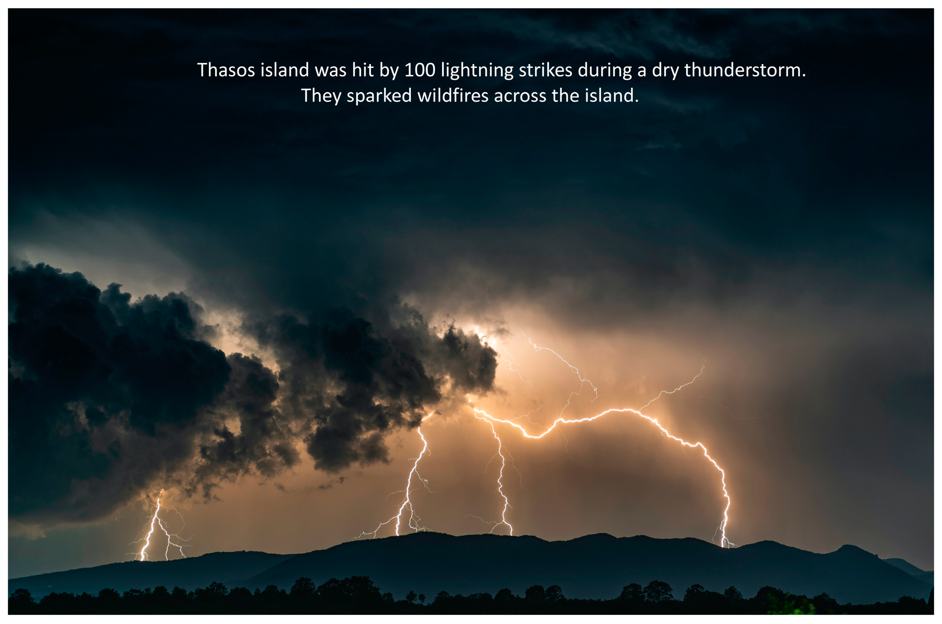
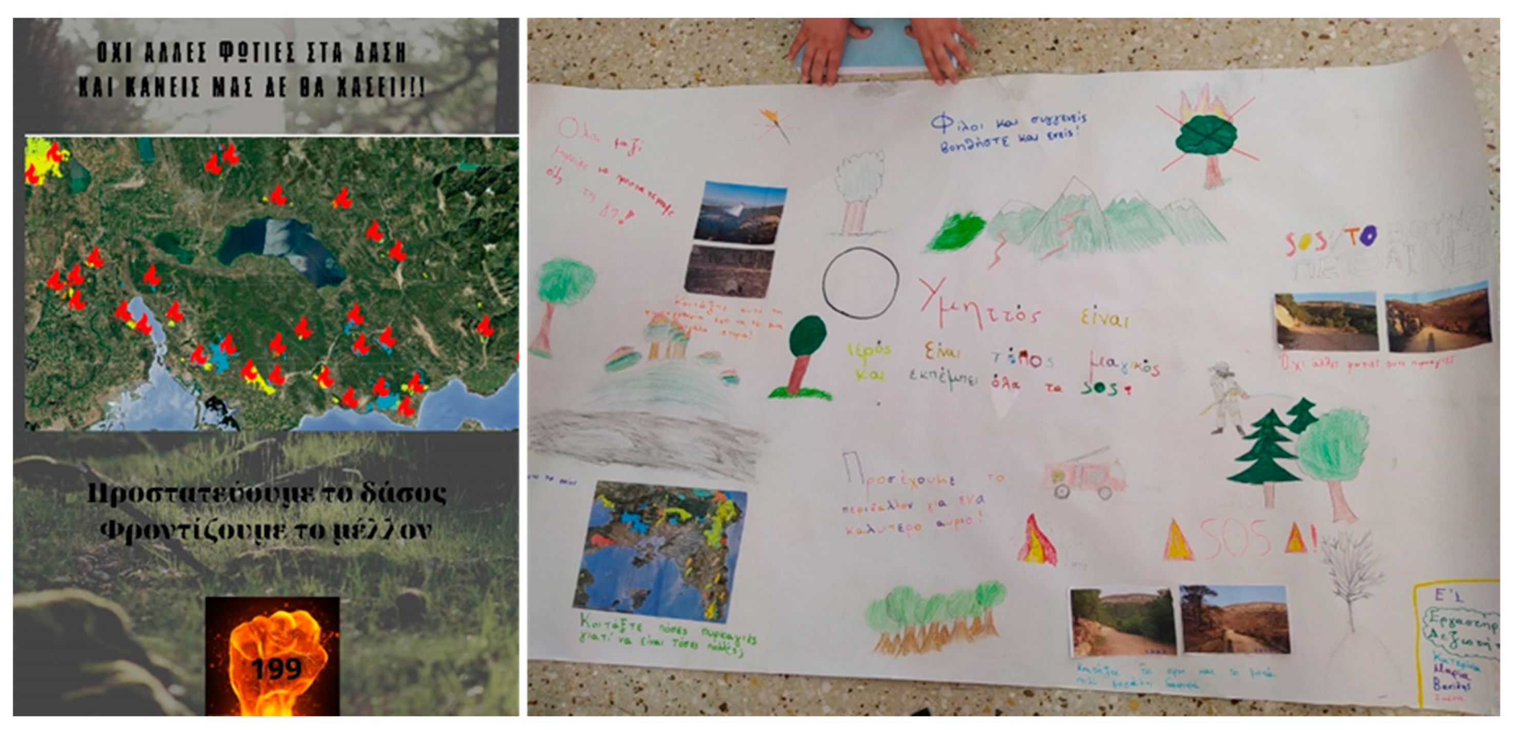
2.3.2. LP-2: “Hot News”
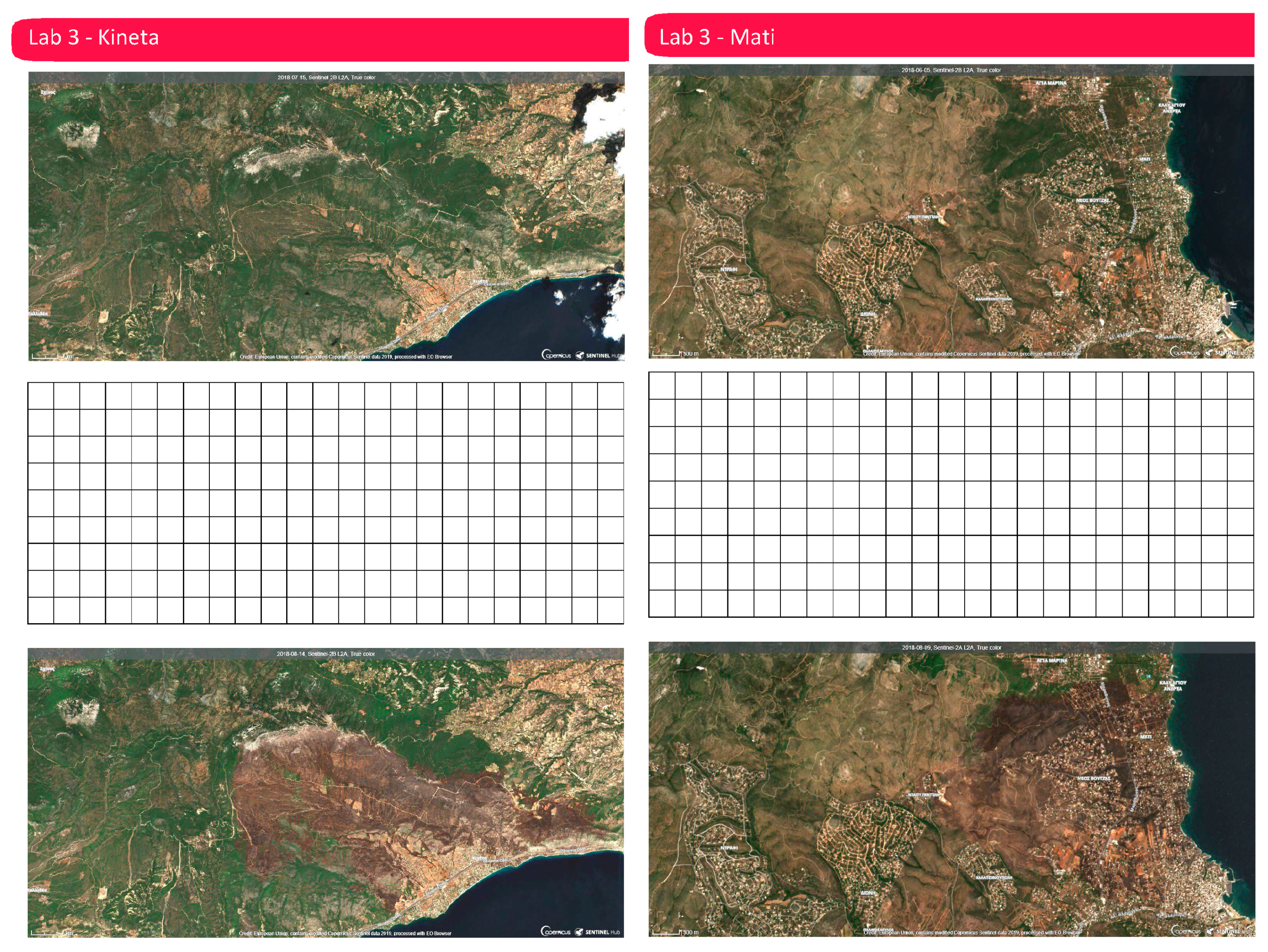
2.3.3. LP-3: “Hands-on Fire Scar Mapping”
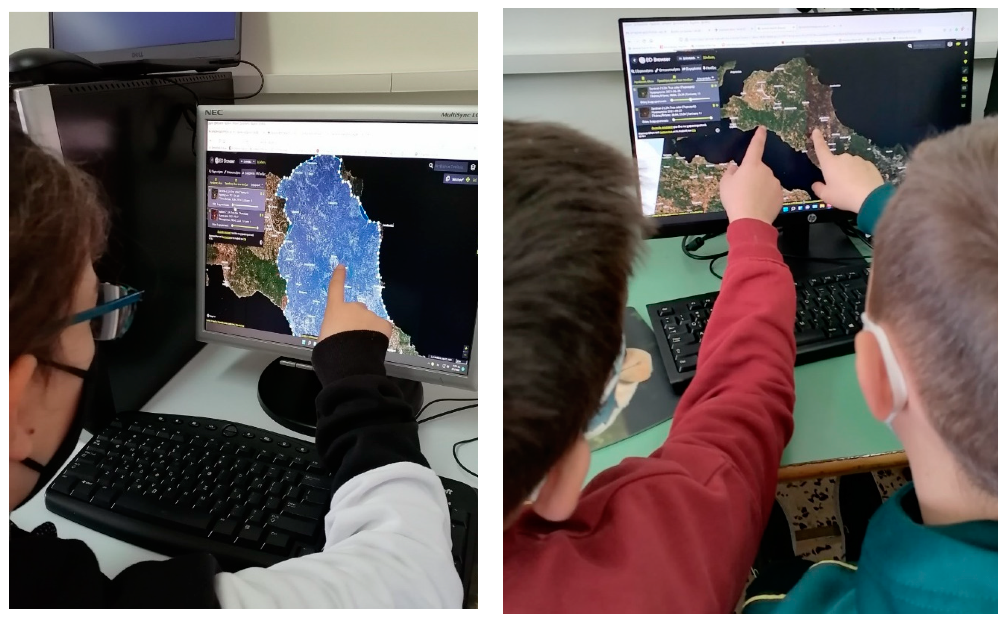
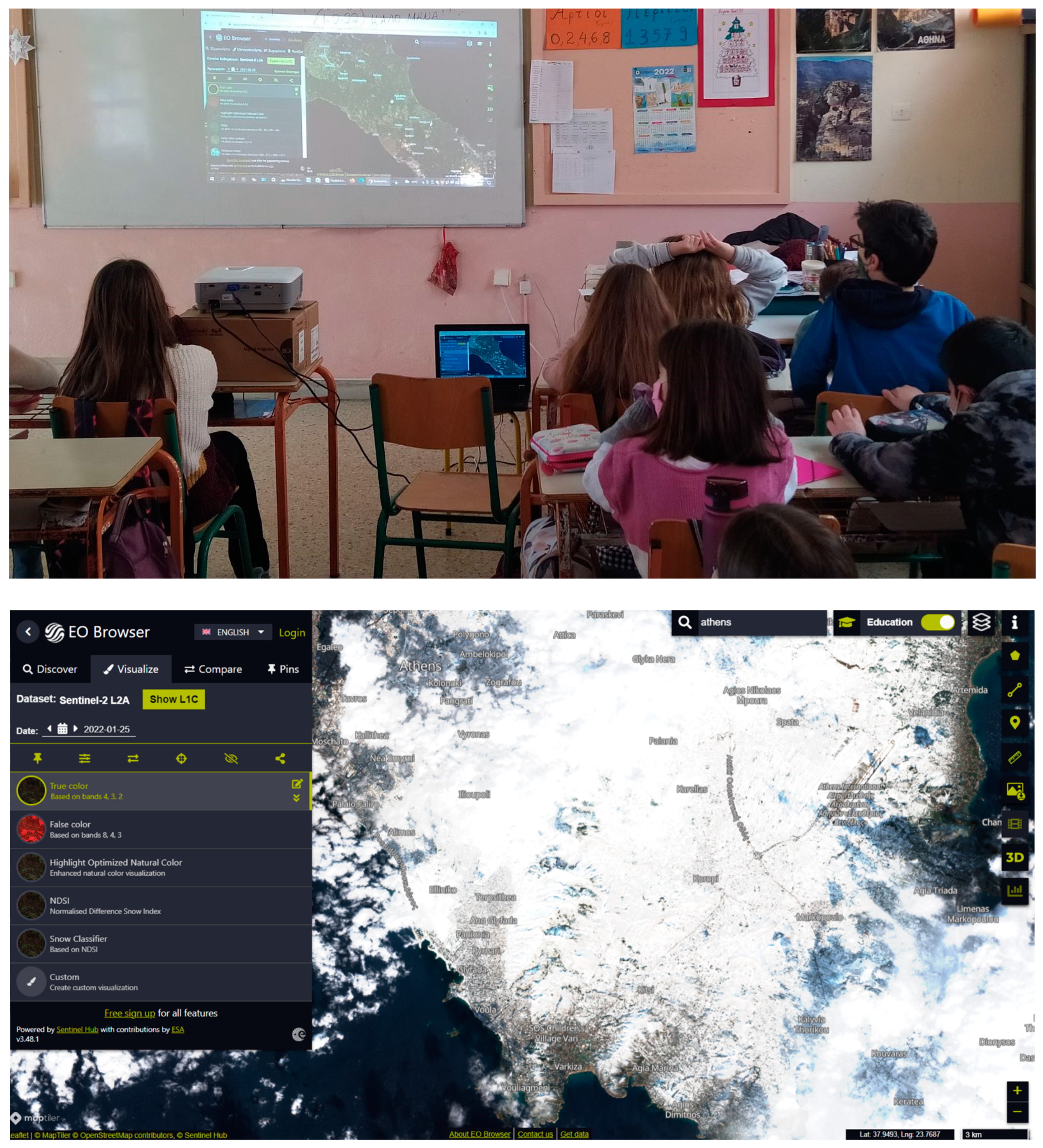
2.3.4. LP-4: “Fire Scar Mapping with EO Browser”
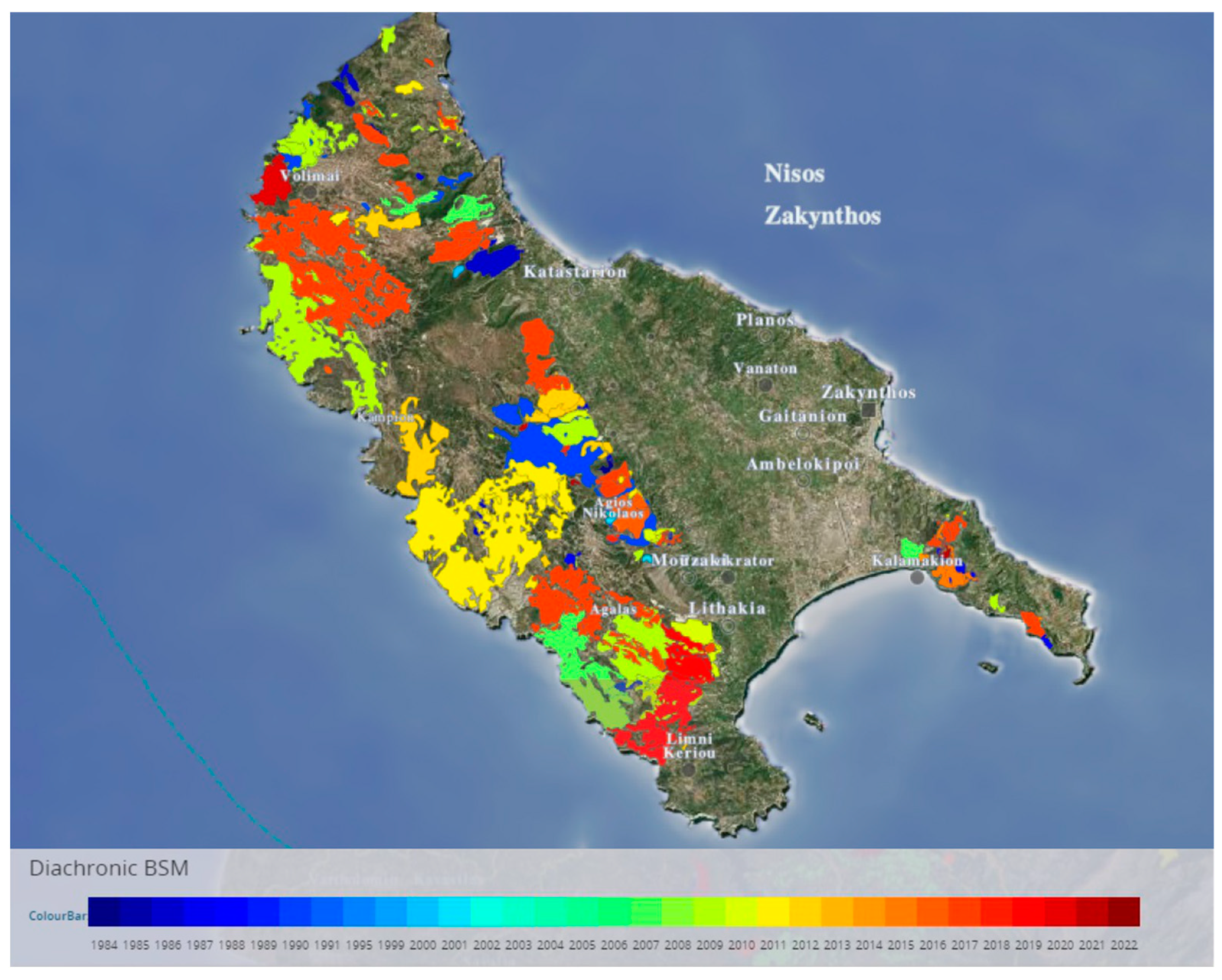
2.3.5. LP-5: “How Much Has Your Region Suffered from Fires?”
2.3.6. LP-6 and 7: “Evaluate What You Learned and Spread the News”
2.4. Evaluation Methodology
- Determine if MaFiSS is sufficiently self-explanatory, and user-friendly for teachers with no prior EO knowledge to implement independently without the need for external support or guidance;
- Evaluate whether the educational scenario, according to teachers, attracts and maintains student interest;
- Evaluate MaFiSS’ adaptability in meeting the specific requirements of different schools for highlighting the local effects of wildfires;
- Investigate whether the programme stimulates students’ and teachers’ interest for satellites and EO;
- Evaluate whether, according to teachers, the EO-based approach enhances students’ understanding of wildfire magnitude through the combined global, local, and diachronic perspective it offers;
- Assess how well the different learning approaches (i.e., EO-based, phenomenon-based and place-based) work together in synergy, complementing each other;
- Investigate whether links between MaFiSS and concepts taught at school are established, enabling students to make sense of them beyond the context of the respective curricular subjects.
- Examine whether the EO-based approach helps raise awareness and understanding of climate change impacts such as wildfires (environmental objectives);
- Record students’ awareness and prior knowledge regarding satellites, EO, and space-based information and tools (STEM and EO objectives);
- Assess students’ interest stimulation level for satellites and EO (EO and STEM objectives);
- Examine the degree of relevance between MaFiSS and the Greek school curriculum based on the level of associations and connections made with existing curricular topics (curricular objectives);
- Measure students’ programme satisfaction (satisfaction objectives).
3. Results
3.1. Teacher Evaluation Results
3.1.1. Material’s Teacher-Friendliness and Ease of Implementation
3.1.2. Programme Attractiveness and Student Engagement
- Maximum attractiveness and engagement: (i) LP2: dry storm phenomenon and fire disaster press reports; (ii) LP4: EO browser interaction and (iii) LP6: awareness campaign. The success of these lessons was mostly attributed to the impressiveness of the dry storm phenomenon in LP2, the novelty of interacting with EO browser in LP4, and the creative characteristics of LP6.
- Medium attractiveness and engagement: Students exhibited medium interest for LP3 which mainly used fire scar calculation worksheets (see Appendix C.2) and LP5 where students were required to catalog past local wildfires through the Diachronic BSM of Beyond FireHub application (see Appendix C.4). As reported by all teachers, mathematical calculations discouraged quite a few students in LP3 while in LP5 the static nature of the application caused a gradual decrease of interest.
- Minimum attractiveness and engagement: The least favorite activities were the ones contained in LP1: questionnaire completion, analysis of answers, and scientific inquiry, together with the programme evaluation activities in LP7 at the end of the programme.
3.1.3. Suitability of EO Tools for Education
3.1.4. Effectiveness of the Phenomenon-Based Approach
3.1.5. Effectiveness of the EO-Based Approach
3.1.6. Impact on Student Interest for Satellites and EO
3.1.7. Links to Curricular Concepts
3.2. Student Evaluation Results
- The terms and concepts students consider striking and novel are acquired and retained to a great extent. Specifically, it is evident that the dry storm phenomenon made a lasting impression to 65% of the students, followed by EO satellites (52%).
- Applications that enable students to express themselves creatively, such as a word cloud, also made a lasting impression (mean 31%). Please note that only one class (E1-Agrinion) used this application (mentioned 100%).
- Terms such as fire scar mapping, ESA, and hectares left a medium impression to students (21–29%). The acquisition and retention of concepts and terms such as ESA and hectares (29%), we can safely say, is an exception, as it appears only in the answers of one class (E1-Agrinion) and, therefore, can most likely be attributed to the teacher’s persistence and emphasis.
- Concepts and terms about the fire properties, optics, and climate change left a small impression.
4. Discussion and Conclusions
- Cloud-based EO tools, such as the EO browser, are suitable for school use by EO-novice teachers and students who can very quickly become familiar with them and grasp the basic EO concepts, guided solely by written instructions;
- CCSE benefits from the combined use of the EO-based and the place-based approach as it helps bridge the local and the global perspective of CC impacts, such as wildfires, and thus help students better understand both. The EO-based approach not only enables students to construct the big picture of CC impacts, but also enables them to gradually zoom into their local environment where place-based approach is activated. It is indicated that the combination of the two approaches raises student awareness and enhances student understanding of the size of natural hazards’ impact, through the combined global, local, and diachronic perspective it offers;
- EO-based educational material and tools stimulate student interest for learning more about satellites and EO and promote their upskilling, especially when they get the chance to interact personally with the relevant applications;
- The phenomenon-based approach and specifically the dry storm phenomenon grabs teachers’ and students’ attention, provokes their curiosity, and acts as a springboard for scientific inquiry of climate change impacts such as wildfires;
- The combined use of EO-based applications and novel pedagogical approaches promotes teachers’ upskilling and provokes spontaneous intra-school collaboration. As seen during MaFiSS implementation, ICT teachers collaborated voluntarily with primary school teachers because they got personally interested in learning more about the EO tools used in MaFiSS;
- Finally, the inherent interdisciplinary nature of the EO-based pedagogical material blends naturally with a lot of topics in the Greek primary school curriculum. It is indicated that teachers utilize these correlations, thus helping students to make sense of concepts taught at school beyond the classroom context.
Author Contributions
Funding
Informed Consent Statement
Data Availability Statement
Acknowledgments
Conflicts of Interest
Appendix A
Appendix B

| Open and Close-Ended Survey Questions | Possible Answers |
|---|---|
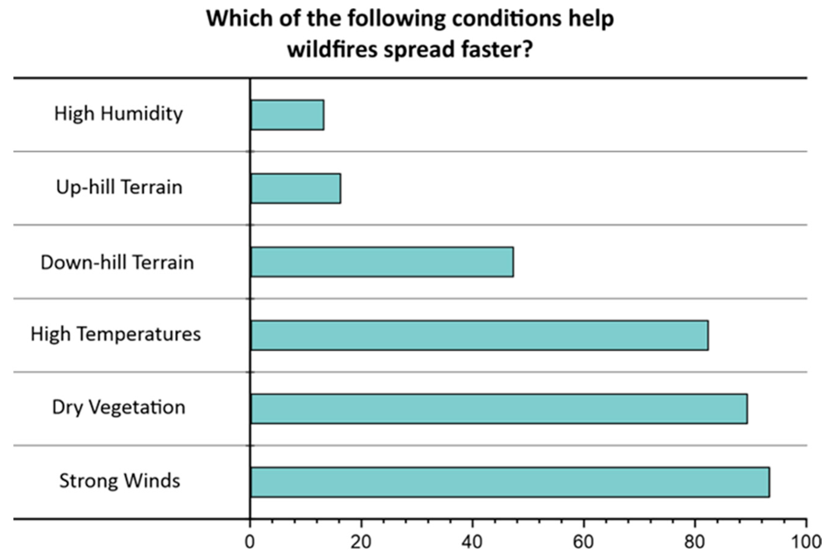
| Q.1 Which of the following conditions help wildfires spread faster? | A.1. Choose as many answers as you think apply: Strong winds/High temperatures/High humidity/Up-hill terrain/Dry vegetation/Down-hill terrain |
| Q.2. Wildfires are caused either by human actions or by natural phenomena like lightning and volcanoes. What do you think sparks most of the fires in the Mediterranean forests? | A.2. Choose only one answer: Mostly human actions/Mostly natural causes/Both equally |
| Q.3. What human actions do you know which can cause a wildfire? | A.3. Write what you know |
| Q.4. In which of the following areas of the world do you think most wildfires occur? | A.4. Choose only one answer: African forest and savannas/Amazon tropical forests/Mediterranean forest/Boreal forests |
| Q.5. How long do you think wildfires can last in Siberia, Canada, or Alaska? | A.5. Choose only one answer: Hours/Days/Months |
| Q.6. Global warming is changing the earth’s climate and increases weather extremes, which in turn amplify forest fires. Which of the following weather extremes do you think contribute the most to wildfires? | A.6. Choose as many answers as you think apply: Stronger winds/extended heat waves/extreme storms/increased lightning activity/extreme snowstorms/reduced precipitation |
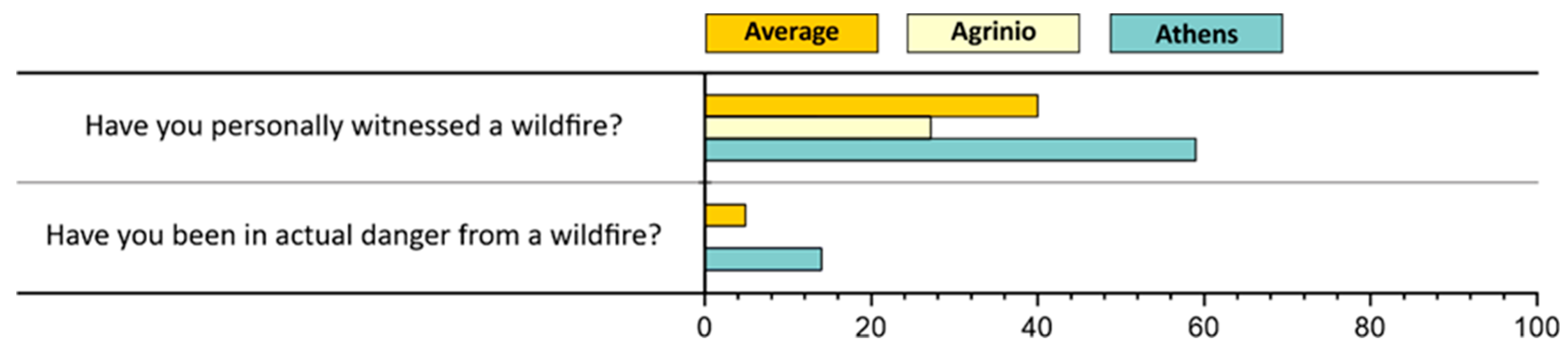
| Q.7. Have you ever witnessed a wildfire in the past? | A.7. Choose one answer: Yes/No |
| Q.7.1. If yes, has you, or anyone from your family, been in danger because of that wildfire? | A.7.1. Choose one answer: Yes/No |
| Q.8. Which catastrophic wildfires in Greece or abroad do you remember? | A.8. Write what you know |
Appendix C
Appendix C.1. Wildfires Survey Worksheets

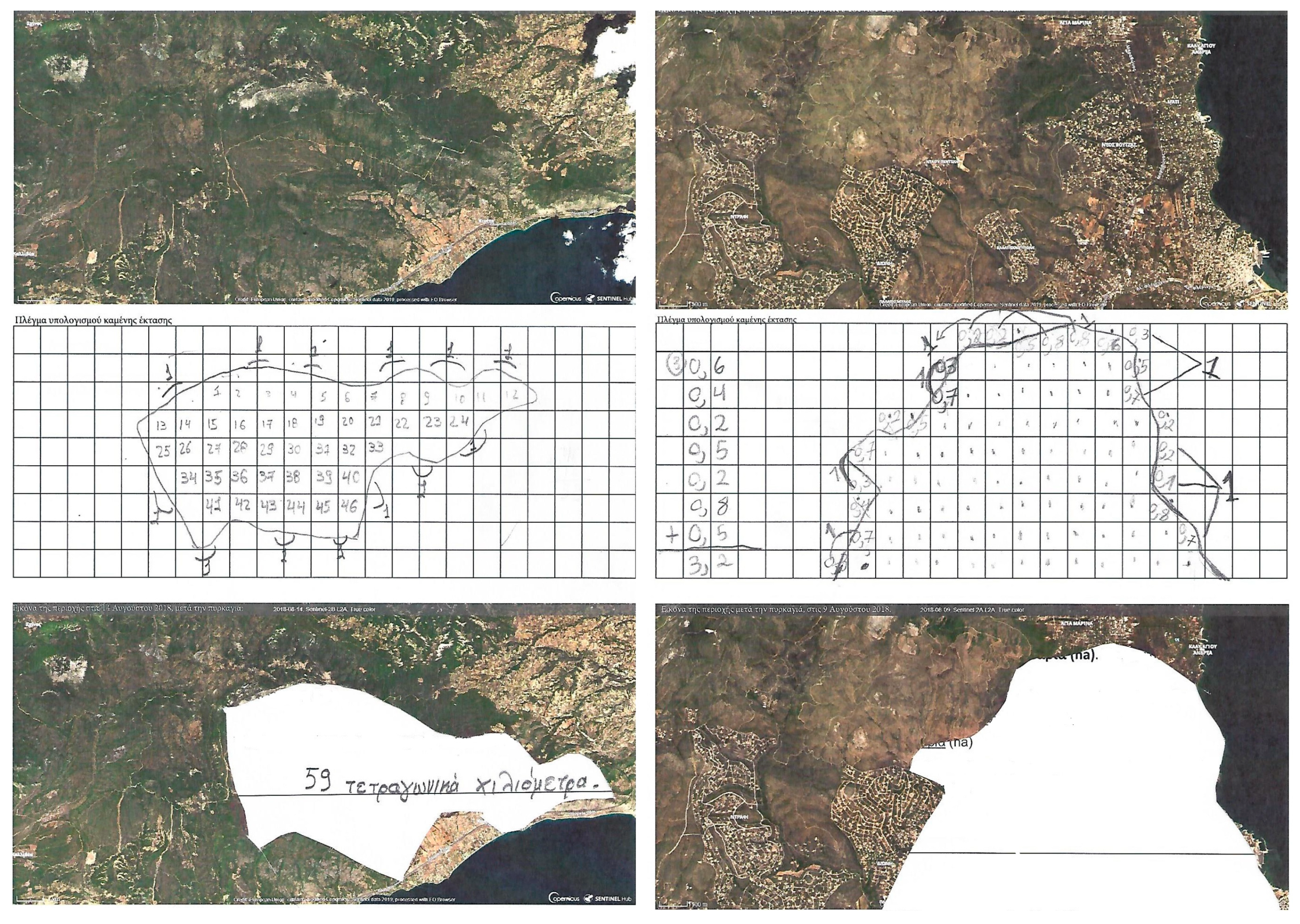
Appendix C.2. Fire Scar Mapping Worksheets
Appendix C.3. EO Browser Interactions
Appendix C.4. BEYOND Diachronic BSM Products
References
- McKay, D.I.A.; Staal, A.; Abrams, J.F.; Winkelmann, R.; Sakschewski, B.; Loriani, S.; Fetzer, I.; Cornell, S.E.; Rockström, J.; Lenton, T.M. Exceeding 1.5 °C global warming could trigger multiple climate tipping points. Science 2022, 377, 6611. [Google Scholar] [CrossRef]
- UNFCCC. United Nations Framework Convention on Climate Change. 1992. United Nations. Available online: https://unfccc.int/sites/default/files/conveng.pdf (accessed on 1 July 2023).
- United Nations. Paris Agreement. 2015. Available online: https://unfccc.int/sites/default/files/english_paris_agreement.pdf (accessed on 30 August 2023).
- European Commission. Communication on The European Green Deal. 2019. Available online: https://commission.europa.eu/document/daef3e5c-a456-4fbb-a067-8f1cbe8d9c78_en (accessed on 22 July 2023).
- European Commission European Commission. Education for Climate Coalition. 2021. Available online: https://education-for-climate.ec.europa.eu/community/ (accessed on 1 July 2023).
- UNESCO. UN Decade of Education for Sustainable Development, 2005–2014: The DESD at a Glance; UNESCO: Paris, France, 2005. [Google Scholar]
- UNESCO. Climate Change Education for Sustainable Development: The Climate Change Initiative; UNESCO: Paris, France, 2010. [Google Scholar]
- UNESCO. Rethinking Education: Towards a Global Common Good? UNESCO Publishing: Paris, France, 2015; ISBN 978-92-3-100088-1. [Google Scholar]
- UNESCO. Education for Sustainable Development. Available online: https://www.unesco.org/en/education-sustainable-development (accessed on 1 July 2023).
- UNESCO. SDG 4—Education 2030: Part II, Education for Sustainable Development Beyond 2019; UNESCO: Paris, France, 2019. [Google Scholar]
- Yang, J.; Gong, P.; Fu, R.; Zhang, M.; Chen, J.; Liang, S.; Xu, B.; Shi, J.; Dickinson, R. The role of satellite remote sensing in climate change studies. Nat. Clim. Chang. 2013, 3, 875–883. [Google Scholar] [CrossRef]
- Cox, H.; Kelly, K.; Yetter, L. Using Remote Sensing and Geospatial Technology for Climate Change Education. J. Geosci. Educ. 2014, 62, 609–620. [Google Scholar] [CrossRef]
- Adaktylou, N. Remote Sensing as a Tool for Phenomenon-Based Teaching and Learning at the Elementary School Level: A Case Study for the Urban Heat Island Effect. Int. J. Educ. Methodol. 2020, 6, 517–531. [Google Scholar] [CrossRef]
- Dannwolf, L.; Matusch, T.; Keller, J.; Redlich, R.; Siegmund, A. Bringing Earth Observation to Classrooms—The Importance of Out-of-School Learning Places and E-Learning. Remote Sens. 2020, 12, 3117. [Google Scholar] [CrossRef]
- Dziob, D.; Krupiński, M.; Woźniak, E.; Gabryszewski, R. Interdisciplinary Teaching Using Satellite Images as a Way to Introduce Remote Sensing in Secondary School. Remote Sens. 2020, 12, 2868. [Google Scholar] [CrossRef]
- Hodam, H.; Rienow, A.; Jürgens, C. Bringing Earth Observation to Schools with Digital Integrated Learning Environments. Remote Sens. 2020, 12, 345. [Google Scholar] [CrossRef]
- Hodam, H.; Rienow, A.; Juergens, C. Developing and Evaluating Simplified Tools for Image Processing in a Problem-Based Learning Environment for Earth Observation. PFG-J. Photogramm. Remote Sens. Geoinf. Sci. 2022, 90, 439–456. [Google Scholar] [CrossRef]
- Asimakopoulou, P.; Nastos, P.; Vassilakis, E.; Hatzaki, M.; Antonarakou, A. Earth Observation as a Facilitator of Climate Change Education in Schools: The Teachers’ Perspectives. Remote Sens. 2021, 13, 1587. [Google Scholar] [CrossRef]
- Filchev, L.; Manakos, I.; Reuter, R.; Mardirossian, G.; Srebrova, T.; Kraleva, L.; Dimitrov, D.; Marini, K.; Rienow, A. A Review of Earth Observation Resources for Secondary School Education–Part 1. Aerosp. Res. Bulg. 2020, 32, 224–240. [Google Scholar] [CrossRef]
- FIS: Remote Sensing in Schools. Available online: https://fis.rub.de/ (accessed on 12 April 2023).
- Mouratidis, A. EO4Edu- Erasmus+ Project. Available online: https://www.eo4edu.eu/project (accessed on 25 October 2021).
- GIS4Schools: Erasmus+ Project. Available online: https://gis4schools.eu/#/home (accessed on 12 April 2023).
- Lindner, C.; Rienow, A.; Otto, K.-H.; Juergens, C. Development of an App and Teaching Concept for Implementation of Hyperspectral Remote Sensing Data into School Lessons Using Augmented Reality. Remote Sens. 2022, 14, 791. [Google Scholar] [CrossRef]
- Columbus Eye: Teaching EO Material from ISS. Available online: http://columbuseye.rub.de/unterricht/ (accessed on 12 April 2023).
- Karatza, A.; Galani, L.; Parcharidis, I. Teaching “Climate Change and Glaciers” Using ESA-Eduspace Material. Curr. J. Appl. Sci. Technol. 2020, 39, 68–78. [Google Scholar] [CrossRef]
- Climate Detectives: ESA Education School Project. Available online: http://www.esa.int/Education/Climate_detectives (accessed on 18 December 2022).
- Amici, S.; Tesar, M. Building Skills for the Future: Teaching High School Students to Utilize Remote Sensing of Wildfires. Remote Sens. 2020, 12, 3635. [Google Scholar] [CrossRef]
- Schulman, K.; Fuchs, S.; Hämmerle, M.; Kisser, T.; Laštovička, J.; Notter, N.; Stych, P.; Väljataga, T.; Siegmund, A. Training teachers to use remote sensing: The YCHANGE project. Rev. Int. Geogr. Educ. Online 2021, 11, 372–409. [Google Scholar] [CrossRef]
- Voss, K.; Goetzke, R.; Hodam, H. Methods and potentials for using satellite image classification in school lessons. In Remote Sensing for Agriculture, Ecosystems, and Hydrology XIII; Neale, C.M.U., Maltese, A., Eds.; SPIE: Bellingham, WA, USA, 2011; Volume 8174, p. 81740K. [Google Scholar] [CrossRef]
- Galani, L. Thematic development and extension of Greek Geography Curriculum via the use of satellite images in the classroom. In Proceedings of the 9th Hellenic Conference of ENEFET, Athens, Greece, 6–9 December 2016; Psillos, D., Molohidis, A., Kallery, M., Eds.; Aristotle University of Thessaloniki: Thessaloniki, Greece, 2016; pp. 884–891. [Google Scholar]
- ESERO Greece. Available online: https://esero.gr/ (accessed on 12 July 2023).
- MaFiSS as Listed on the Approved Programmes by the Greek Institute of Educational Policy. Available online: https://elearning.iep.edu.gr/study/mod/folder/view.php?id=60328 (accessed on 2 July 2023). (In Greek).
- Griffin, P.; Care, E. Assessment and Teaching of 21st Century Skills; Springer: Dordrecht, The Netherlands, 2015. [Google Scholar]
- Trilling, B.; Fadel, C. 21st Century Skills: Learning for Life in Our Times; Jossey-Bass/Wiley: San Francisco, CA, USA, 2009; ISBN 978-0-470-47538-6. [Google Scholar]
- Budhai, S.; Taddei, L. Teaching the 4Cs with Technology: How do I Use 21st Century Tools to Teach 21st Century Skills? ASCD Arias: Washington, DC, USA, 2015. [Google Scholar]
- Griffin, P.; Care, E. Developing learners’ collaborative problem solving skills. European Schoolnet Academy. 2014. Available online: http://vp-learningdiaries.weebly.com/uploads/9/4/9/8/9498170/developing_learners_collaborative_problem_solving_p_griffin.pdf (accessed on 22 September 2023).
- Minner, D.D.; Levy, A.J.; Century, J. Inquiry-based science instruction—What is it and does it matter? Results from a research synthesis years 1984 to 2002. J. Res. Sci. Teach. 2010, 47, 474–496. [Google Scholar] [CrossRef]
- Constantinou, C.P.; Tsivitanidou, O.E.; Rybska, E. What Is Inquiry-Based Science Teaching and Learning. In Professional Development for Inquiry-Based Science Teaching and Learning; Tsivitanidou, O.E., Gray, P., Rybska, E., Louca, L., Constantinou, C.P., Eds.; Springer: Cham, Switzerland, 2018; pp. 1–23. [Google Scholar]
- Baraquia, L.G. Interdisciplinary Contextualization and Inquiry-Based Learning: How Engaging Can It Be? Int. J. Sci. Eng. Investig. 2018, 7, 81. [Google Scholar]
- Markaki, V. Environmental Education through Inquiry and Technology. Sci. Educ. Int. 2014, 25, 8686–8692. [Google Scholar]
- Murphy, C.; Smith, G.; Mallon, B.; Redman, E. Teaching about sustainability through inquiry-based science in Irish primary classrooms: The impact of a professional development programme on teacher self-efficacy, competence and pedagogy. Environ. Educ. Res. 2020, 26, 1112–1136. [Google Scholar] [CrossRef]
- Wood, D.; O’Malley, C. Collaborative learning between peers: An overview. Educ. Psychol. Pract. 1996, 11, 4–9. [Google Scholar] [CrossRef]
- Palincsar, A.S.; Herrenkohl, L.R. Designing collaborative learning contexts. Theory Pract. 2002, 41, 26–32. [Google Scholar] [CrossRef]
- Niemi, H. Active learning—A cultural change needed in teacher education and schools. Teach. Teach. Educ. 2002, 18, 763–780. [Google Scholar] [CrossRef]
- Mattila, P.; Silander, P. Phenomenon-Based Learning as the pedagogical approach for eLearning. In How to Create the School of the Future—Revolutionary Thinking and Design from Finland; University of Oulu Center for Internet Excellence: Oulu, Finland, 2015. [Google Scholar]
- Symeonidis, V.; Schwarz, J.F. Phenomenon-Based Teaching and Learning through the Pedagogical Lenses of Phenomenology: The Recent Curriculum Reform in Finland. Forum Oświatowe 2016, 28, 31–47. [Google Scholar]
- Gruenewald, D.; Smith, G.A. Place-Based Education in the Global Age: Local Diversity; Routledge: New York, NY, USA; London, UK, 2008; ISBN 9780805858631. [Google Scholar]
- Semken, S.; Freeman, C.B. Sense of place in the practice and assessment of place-based science teaching. Sci. Educ. 2008, 92, 1042–1057. [Google Scholar] [CrossRef]
- Filippaki, A.; Kalaitzidaki, M. Sense of place in Environmental Education. Environ. Educ. Sustain. 2022, 3, 49–64. [Google Scholar] [CrossRef]
- Sobel, D. Place-Based Education: Connecting Classrooms and Communities, 2nd ed.; Orion Society: Great Barrington, MA, USA, 2005. [Google Scholar]
- Somerville, M.J. A Place Pedagogy for ‘Global Contemporaneity’. Educ. Philos. Theory 2010, 42, 326–344. [Google Scholar] [CrossRef]
- EO Browser. The Free Spatial Visualization Tool of the Copernicus Programme. Available online: https://apps.sentinel-hub.com/eo-browser/ (accessed on 2 July 2023).
- Sentinel Playground. Available online: https://apps.sentinel-hub.com/sentinel-playground/ (accessed on 3 July 2023).
- Bampasidis, G.; Galani, A.; Parcharidis, I.; Lambrinos, N. Spaceborne teaching resources: Critical evaluation of Remote Sensing software packages for upper primary and secondary education. In Proceedings of the 12th Panhellenic & International Conference «ICT in Education», Florina, Greece, 14–16 May 2021. [Google Scholar]
- EO Browser Improvements: New Education Mode with New Themes. Available online: https://medium.com/sentinel-hub/new-themes-multi-temporal-scripting-and-other-improvements-in-eo-browser-725267d09f2f (accessed on 20 June 2023).
- EO Browser Improvements: Multi-Language Support. Available online: https://medium.com/sentinel-hub/eo-browser-updates-summer-2021-7bc13a399514 (accessed on 31 May 2023).
- Diachronic BSM by BEYOND EO Center. Available online: http://ocean.space.noa.gr/diachronic_bsm/ (accessed on 20 January 2022).
- BEYOND Center for EO Research and Satellite Remote Sensing. Available online: http://beyond-eocenter.eu/ (accessed on 20 January 2022).
- Aeolus Science Conference 2023. Available online: https://www.aeolus2023.org/ (accessed on 11 September 2023).


| Lesson Plan | Activities and Tools | Learning Methods |
|---|---|---|
| LP-1: Did you know? | Introduces the subject of wildfires through a brief printed questionnaire designed to spark student curiosity. Following that, students collect and analyze answers using Excel and finally, search for the correct answers using printed, popularized scientific texts. |
|
| LP-2: Hot News | Students are exposed to an attention-grabbing image of a dry storm and study the phenomenon causes, based on supportive PowerPoint material. Subsequently, they study different media reports about past wildfires that have devastated Greece for discovering previously unknown causes and impacts. Finally, they organize their newly acquired knowledge, using digital Mind Map software |
|
| LP-3: Handmade, fire scar mapping | Students engage in a hands-on mapping activity of burned areas, using printed worksheets featuring satellite images which depict regions in Greece both before and after the devastating fires of 2018. |
|
| LP-4: Fire scar mapping with EO browser | Students are introduced to basic remote sensing concepts and presented with tips on interpreting satellite images based on a PowerPoint presentation. Following that, students locate, analyze, and digitally map the fire scars examined in LP-3, as well as other local ones of their choice, using EO browser. |
|
| LP-5: How much has your region suffered from fires? | Students study the extent their region has been affected by wildfires diachronically, using the “Diachronic Burnt Scar Mapping” service of the BEYOND EO Center of NOA. Students visit local areas devasted by fire and reflect critically on causes, impacts, and prevention measures. |
|
| LP-6: Spread the news | Students collaboratively design and implement an awareness campaign targeted at the school or local community. They create hand-painted posters or use digital poster maker tools, PowerPoint, video editors, et al. |
|
| LP-6: Evaluate | Students are guided to recall all the stages of the programme, discuss, and evaluate the learning process and its outcomes, using printed evaluation forms |
|
| Question Category | Teacher Feedback Question | Answers & Frequency |
|---|---|---|
| Material’s teacher-friendliness | TFQ.1: Were the scenario and the instructions clear and easy to follow, enabling you to independently implement MaFiSS? |
|
| Degree of teacher preparation | TFQ.2: To what extent did you need to prepare for the implementation of each lesson? |
|
| Infrastructure requirements | TFQ.3: Was your school’s technical infrastructure, adequate for the implementation of MaFiSS? |
|
| Lesson time sufficiency | TFQ.4: Was the lesson time generally sufficient for the completion of the activities of each LP? |
|
| Lesson time sufficiency | TFQ.4 Supporting: Which activities, if any, exceeded the lesson time and how did you manage to complete the activities? |
|
| Material age appropriateness | TFQ.5: Was the pedagogical material age appropriate for your students? |
|
| Programme attractiveness | TFQ.6: Was the programme attractive and engaging for your students? |
|
| Programme attractiveness | TFQ.6 Supporting: Which activities, if any, were the most attractive and engaging for your students? |
|
| Programme attractiveness | TFQ.6 Supporting: Which activities, if any, didn’t manage to maintain student interest and why? |
|
| Implementation difficulties | TFQ.7: Did you encounter any difficulties during the implementation of MaFiSS? |
|
| Implementation difficulties | TFQ.7 Supporting: What kind of difficulties did you face? |
|
| Phenomenon approach effectiveness | TFQ.8: Did the phenomenon-based approach in LP2-dry storm- attracted student interest and provoke reflection? |
|
| Educational Suitability of EO Apps | TFQ.9: Do you consider the EO-based applications utilized in MaFiSS easy to use and suitable for educational purposes? |
|
| Educational Suitability of EO Apps | TFQ.9 Supporting: Did your students have the chance to interact personally with the web applications EO Browser/Beyond FireHub? |
|
| EO-based approach effectiveness | TFQ.10: To what extent, the use of satellite images and EO-based applications helped your students grasp the scale, magnitude, and timelessness of the wildfires’ phenomenon both at local and global level? |
|
| Student EO interest impact | TFQ.11: Did you observe any increase in your students’ interest for space, satellites and EO technology? |
|
| Student EO interest | TFQ.11 Supporting: How was that interest manifested? |
|
| Links to curricular topics | TFQ.12: Did MaFiSS helped you enrich or broaden the scope of the curricular subjects you teach? |
|
| Links to curricular topics | TFQ.12 Supporting: Which of the subjects you teach benefited and how? |
|
| Teachers’ satisfaction | TFQ.13: Did the program material meet your expectations? |
|
| Teachers’ satisfaction | TFQ.14: Would you recommend MaFiSS to a colleague? |
|
| Recommendations for improvement | TFQ.15: What would you recommend for improving the material? |
|
| Objectives Category | SEQ Questions | Not at All | a Little | Fairly | a Lot |
|---|---|---|---|---|---|
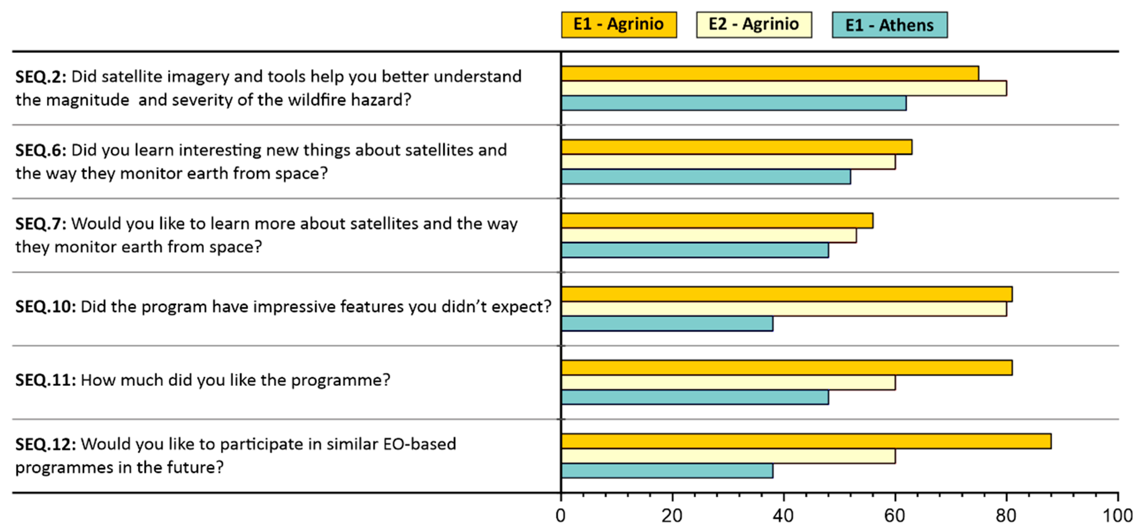
| Environmental | SEQ.1: Did you learn new things about wildfires that you were not aware before? | 0% | 0% | 48% | 52% |
| Environmental | SEQ.2: Did satellite imagery and tools help you better understand the magnitude and severity of the wildfire hazard? | 0% | 8% | 21% | 71% |
| Environmental | SEQ.3: Did satellite imagery and tools help you better understand how your region has been affected by wildfires in the past? | 0% | 4% | 31% | 65% |
| Environmental | SEQ.4: Can you explain to others (parents or friends) how climate change is affecting wildfires and vice versa? | 6% | 29% | 54% | 12% |
| EO & STEM | SEQ.5: Prior to your participation in this programme, how much did you know about satellites and Earth Observation? | 31% | 58% | 12% | 0% |
| EO & STEM | SEQ.6: Did you learn interesting new things about satellites and the way they monitor earth from space? | 0% | 12% | 31% | 58% |
| EO & STEM | SEQ.7: Would you like to learn more about satellites and the way they monitor earth from space? | 2% | 12% | 35% | 52% |
| Curricular | SEQ.8: Did the programme help you better understand topics you are taught in other curricular subjects (such as optics, human vision, photosynthesis, Greek language etc.)? | 6% | 13% | 54% | 27% |
| Curricular | SEQ.9: Did the programme applications help you improve your map navigation and orientation skills? | 4% | 23% | 50% | 23% |
| Satisfaction | SEQ.10: Were there impressive features in the programme that didn’t expect to find at the start? | 0% | 8% | 29% | 63% |
| Satisfaction | SEQ.11: How much did you like the programme? | 0% | 6% | 33% | 62% |
| Satisfaction | SEQ.12: Would you like to participate in similar EO-based programmes in the future? | 0% | 12% | 29% | 60% |
| No of Words or Concepts | New Words or Concepts | Percentage of Answers | |||
|---|---|---|---|---|---|
| Mean: 52 Answers | E1-Agrinion: 16 Answers | E2-Agrinion: 15 Answers | E1-Athens: 21 Answers | ||
| 1 | Dry Storm | 65% | 88% | 87% | 33% |
| 2 | EO Satellites | 52% | 63% | 47% | 48% |
| 3 | Word cloud application | 31% | 100% | 0% | 0% |
| 4 | ESA | 29% | 94% | 0% | 0% |
| 5 | Hectares (ha) | 29% | 94% | 0% | 0% |
| 6 | Fire scar mapping | 21% | 7% | 47% | 14% |
| 7 | Arson, Fire fuel, how fire spreads faster uphill 1 | 17% | 0% | 33% | 19% |
| 8 | Active reforestation | 13% | 0% | 47% | 0% |
| 9 | Fire-hub application | 12% | 0% | 0% | 29% |
| 10 | Light properties and optics (light reflection and absorption, how we see colors etc.) | 10% | 0% | 0% | 24% |
| 11 | Climate change | 6% | 0% | 20% | 0% |
Disclaimer/Publisher’s Note: The statements, opinions and data contained in all publications are solely those of the individual author(s) and contributor(s) and not of MDPI and/or the editor(s). MDPI and/or the editor(s) disclaim responsibility for any injury to people or property resulting from any ideas, methods, instructions or products referred to in the content. |
© 2023 by the authors. Licensee MDPI, Basel, Switzerland. This article is an open access article distributed under the terms and conditions of the Creative Commons Attribution (CC BY) license (https://creativecommons.org/licenses/by/4.0/).
Share and Cite
Asimakopoulou, P.; Nastos, P.; Vassilakis, E.; Antonarakou, A.; Hatzaki, M.; Katsigianni, O.; Papamatthaiou, M.; Kontoes, C. Climate Change Education through Earth Observation: An Approach for EO Newcomers in Schools. Sustainability 2023, 15, 14454. https://doi.org/10.3390/su151914454
Asimakopoulou P, Nastos P, Vassilakis E, Antonarakou A, Hatzaki M, Katsigianni O, Papamatthaiou M, Kontoes C. Climate Change Education through Earth Observation: An Approach for EO Newcomers in Schools. Sustainability. 2023; 15(19):14454. https://doi.org/10.3390/su151914454
Chicago/Turabian StyleAsimakopoulou, Panagiota, Panagiotis Nastos, Emmanuel Vassilakis, Assimina Antonarakou, Maria Hatzaki, Ourania Katsigianni, Maria Papamatthaiou, and Charalampos (Haris) Kontoes. 2023. "Climate Change Education through Earth Observation: An Approach for EO Newcomers in Schools" Sustainability 15, no. 19: 14454. https://doi.org/10.3390/su151914454
APA StyleAsimakopoulou, P., Nastos, P., Vassilakis, E., Antonarakou, A., Hatzaki, M., Katsigianni, O., Papamatthaiou, M., & Kontoes, C. (2023). Climate Change Education through Earth Observation: An Approach for EO Newcomers in Schools. Sustainability, 15(19), 14454. https://doi.org/10.3390/su151914454