
Mapping the Multi-Vulnerabilities of Outdoor Places to Enhance the Resilience of Historic Urban Districts: The Case of the Apulian Region Exposed to Slow and Rapid-Onset Disasters


Abstract
:1. Introduction
- The parametrization of the built environment, intended as a system of buildings and unbuilt areas, infrastructures, and people, according to three main sub-classes of characters. Here, the process focuses on the framing of tools, strategies and methodologies already tested—even for built areas without historical character—in the technical-scientific field, highlighting the features of the built environment that influence their physical vulnerability to the selected RODs and SODs (Section 2).
- The discussion of methods and tools for the recognition of vulnerable sub-district areas to MAH scenarios, following main sectorial approaches and tools (Section 3).
- Application to the case study to set and test data and methods (Section 4).
- Discussion for implementing future goals and developments (Section 5).
2. Parametrization of the Historic District Characters for the Analysis of Multi-Asynchronous-Hazardous Events in the Apulia Region
- The hazard refers to the possible occurrences of events that could affect the exposed elements in the built environment.
- The exposure concerns the set of elements in the built environment directly exposed to dangerous events.
- The vulnerability is usually related to the susceptibility of exposed elements to suffer damages of dangerous effects during and after disasters. Particularly, the “vulnerability” class can involve the “physical” and “social” dimensions, depending on the elements considered in the analysis.
- “Natural environment”, including natural boundary conditions (e.g., geological/geotechnical, climatological).
- “Users” that live and interact with the built spaces (inhabitants, tourists).
- “Built environment” as the system of technical choices and their implementation in constructing cities.
- ROD: among the hydrogeological occurrences classified in [19], floods, landslides, and earthquakes are recognized as possible natural RODs, as resulting from national and regional classification [20,21]. Terrorist actions as humans-induced ROD is selected, due to the increasing cultural attraction of the Apulian territory [22], above all in spring and summer.
- SOD: Heatwave is chosen as a SOD caused by meteorological events [19]. The current attention to the Mediterranean area in the climate change process [23], as well as for the increasing likelihood of extreme events in the south of Italy in future climatological scenarios [24], includes the Apulia Region in such exposed territories. However, the main attention is on the amplifying impact resulting from the combination of extreme meteorological events (e.g., heatwaves) and morpho-constructive features of the built environment and uses, which increase locally the temperatures, recognized as the urban heat island effect.
2.1. Environmental Parameters for RODs and SODs
2.2. Built Parameters for RODs and SODs
- The relation among buildings within blocks, thus as aggregate or isolated ones, aiming at studying their interaction during events (as a single building’s movements or effects on adjacent buildings) [R.B.1].
- Geometric data of buildings, as well as their morpho-typological classes, which encompass the number of floors, height, and surface footprints. Additionally, geometric regularities in plan and vertical development are included [R.B.4].
- Technological information related to construction techniques and materials. In this regard, masonries and floors (or vaults) are prevalent sub-systems to focus on due to their mechanical qualities and interactions [R.B.2].
- State of maintenance of buildings and their components (floors, walls) is evaluated to assess the final mechanical quality of structures. This assessment also considers the state of use/disuse of buildings. Furthermore, the presence of anti-seismic devices can be included in the assessment of parameters [R.B.6].
- Geometric data, including the height and number of floors of buildings [R.B.4]. For floods, the height of the basement floor decreases the likelihood of flooding during the event, while a higher number of storeys increases the vertical resistance to horizontal actions of floods. Instead, geometric factors have less relevance in landslide vulnerability.
- Construction data and material information [R.B.2]. Concerning floods, the continuity of wall increases the flow pressure over larger surfaces, thus, the type of construction techniques and materials affect the overall resistance to external pressure. Similar considerations should be applied to foundations, where the relation between the basement and terrain, as well as their construction technique, can influence the stability of buildings or their parts. These parameters also impact the vulnerability of buildings to landslides, while structural types influence the stability of buildings and some of their parts during the terrain instability.
- Finally, the conservation state of building (foundation and masonries) influences the vulnerability due to a loss of the inherent resistance of the structure [R.B.6].
- If attractors hold significant value for terrorist events due to their inherent significance (special, strategic, or public uses), the external area represents a vulnerable part of the district [R.B.7]. The relation between external areas and exposed buildings is introduced in Li Piani [39], identified as the space of influence (SoI). However, any reference to the extension of such external areas is still discussed in the literature.
- The presence of control systems along the perimeter of the attractor element can influence the intentions of perpetrators in attacking the place. In this case, control systems, considered as “additional” elements in the built environment (e.g., closed circuit television, remote control), constitute a parameter that affects the hazard potential of the place [R.B.5] [37].
- Specific attention is required for obstacles in the BE, including all built components of places that are not directly related to buildings but are part of the real places. Urban furniture, monuments, dehors, and fences are some examples of the inherent capacity to be an obstacle. In line with the other risks, these elements affect the evacuation processes (exposure) of users involved in the attacks [R.B.8] [38]. On the other hand, if obstacles serve as meeting points for inhabitants and tourists, they can be classified as “attractors” increasing the vulnerability of areas where they are located.
- Finally, the morphological configuration of places and areas can be considered as the inherent parameters influencing the vulnerability. The openness of squares or open spaces to external forces, such as vehicles or car bombings, due to their geometric characteristics, constitutes the inherent potentialities for these places to be targeted by perpetrators [R.B.3] [37].
- Morphological features of the district, in terms of sky view factor and shape ratio values of open spaces [43]; both the parameters are related to the openness to the direct solar radiation or the closeness to the solar reflective process among the district surfaces [S.B.1], which also depend on building geometries [S.B.4].
- Thermal and optical properties of district surfaces exposed to environmental stress; in this case, external walls and roofs of buildings [S.B.2] and pavements in open areas (square, streets) [S.B.3] influence the capacity to reflect longwave radiation or to absorb and re-emit heat to/from the massive elements. This effect participates in the overall increase in surface temperature, impacting both the outdoor and indoor comfort of pedestrians and inhabitants, respectively. Thus, these characters are useful in determining the inherent vulnerability of external areas in the districts and inner spaces of buildings, affecting energy needs and health of occupants.
2.3. Socio-Spatial Parameters for RODs and SODs
- Access to risk information and availability of timely lifesaving information [S.H.1–R.H.1]: This pertains to the availability of reliable, useful information sources to inform users about risk behaviours. During events, this can range from a dedicated early warning system for the public to a broadcasting system for recommendations or issuing instructions, ensuring prompt access to informal advice via media and social media through personal communication channels. All of these are intended to provide hazard-related cues to assess the severity of the situation and make appropriate or lifesaving decisions (e.g., whether and how to evacuate).
- Socio-demographic and socio-economic profile of the potentially exposed population [S.H.2–R.H.2]: this encompasses considerations such as gender, race, ethnicity, age, marital status, household size, and the presence of vulnerable individuals (e.g., children, the elderly, and pets), socioeconomic status, educational level, employment status, household income (e.g., income’s relation to the presence of air conditioning), housing type and size, vehicle ownership, and more.
- Knowledge of land use, building purposes, and open space utilization [S.H.3–R.H.3]: Together with information about the location of medical resources, facilities for the vulnerable (e.g., nurseries, kindergartens, and care homes for the elderly), this knowledge helps us understand how activity patterns specific to each place type affect across population groups. This understanding allows us to derive the spatial distribution of people and their accessibility to health services in case of emergencies.
- Social relationships between agents and the extent of attachment to places [R.H.4]: These factors encompass social ties, relationships, and group affiliations (e.g., families, neighbourhood and community groups) through which milling and collaboration or disagreement, negotiation, and time wasting may occur. Conversely, these factors may result in social isolation and marginalization, determining a lack of access to lifesaving resources. “Places” signifies attachment to property, but also familiarity with surroundings (e.g., building layout, routes, etc.), or it may account for the presence of users with limited familiarity with the local area.
- Dynamic spatial interactions between agents and the built environment [R.H.5]: This accounts for both social and spatial interactions among people and their interactions with places based on human spatial behaviour. It requires analysing interactions and interferences between evacuees and rescuers and their interactions and interferences with the environment (e.g., proxemics and spatial surroundings). Evaluating the level of crowding (e.g., changes increasing the number of involved people from dyads to groups and crowds) and the spatial characteristics of the affected area that affect human spatial perceptions (e.g., configurational analysis of the area to assess wayfinding task complexity for individuals and their tendency to follow others).
- Different roles and responsibilities for each involved agent [R.H.6]: This includes emergency managers, coordinators, rescuers, evacuees, etc. For instance, safety delegates trained in safety practices or group leaders responsible for relatives and friends.
- Either direct or indirect knowledge of specific risk dynamics [R.H.7]: This encompasses awareness of long-term risk probability and knowledge of short-term effects of risks. These can be direct (e.g., memories of previous emergency experiences) or indirect (e.g., through training in hazards and emergency management procedures). The ability to process information correctly from credible sources for inhabitants and visitors should also be assessed.
- Presence of people affected by permanent impairments, disabilities, or temporary health conditions [R.H.8]: this includes health status, pre-existing chronic or acute conditions, linguistic barriers, impairments (e.g., vision, hearing, strength, and mobility), and special needs individuals.
- Risk perception and reaction to danger and disruption [R.H.9–S.H.6]: This considers emotional states, risk aversion, subconscious reactions (e.g., shock and panic caused by unexpected events or impediments), judgment errors (e.g., overestimation of capabilities or underestimation of hazards), confidence, and self-efficacy to cope with danger and altered perceptions (e.g., distorted sensation of temperature or thirst).
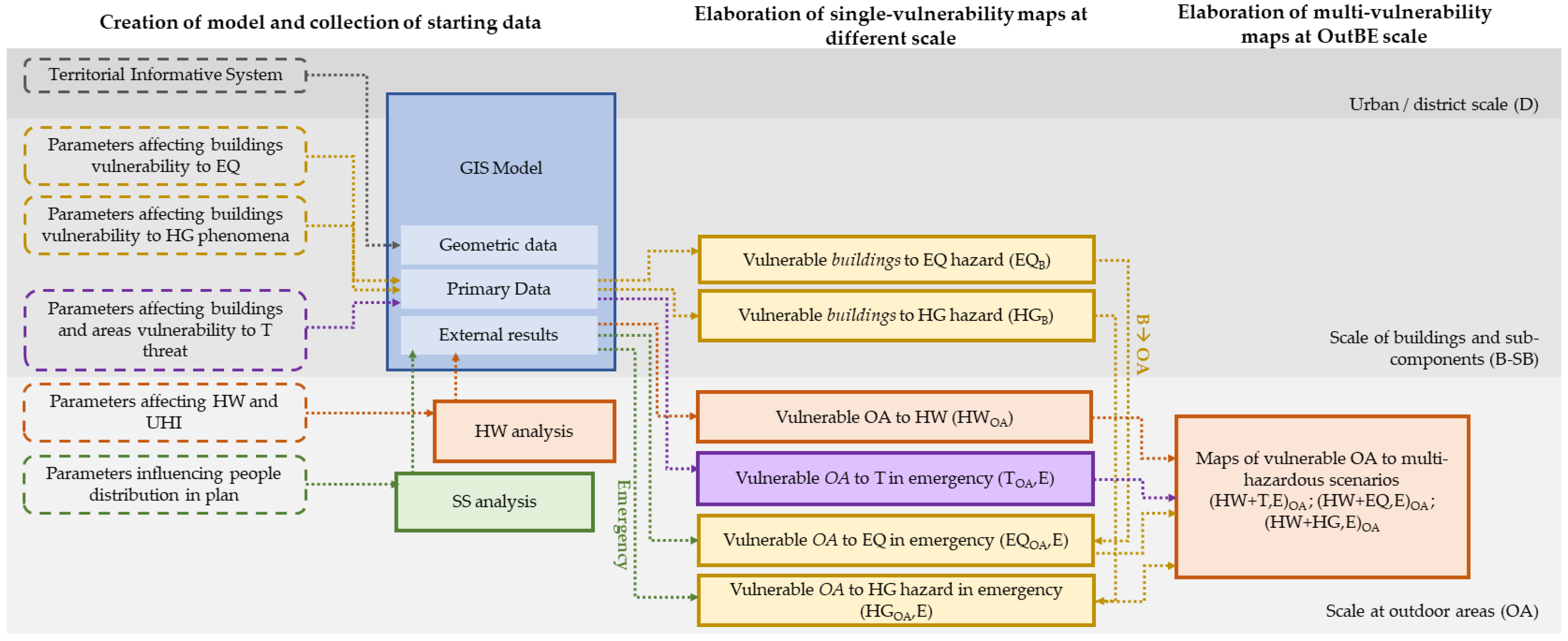
3. Method and Tools to Assess the Physical and Spatial Vulnerability of Historic Cities Due to Multi-Hazardous Events
- Creation of the three-dimensional model of the historic centre and data collection. In this phase, the model is created as the basis of subsequent analyses; moreover, its scale refers to the fundamental units, as a digital surface model (DSM), starting from the shared data in the territorial information system (SIT) of the region [61]. All the required data useful for the analysis of the physical vulnerability of places, both in single and multi-hazardous scenarios, are catalogued in the model or homogenized if derived from external analysis. This phase connects all the following ones, constituting the main common thread in homogenizing data and results towards the creation of vulnerability maps, both for single hazardous conditions and MAH scenarios.
- Elaboration of single-vulnerability maps on different scales. This step involves the analysis of single hazardous events based on the characteristics of RODs and SODs and includes the following sub-steps:
- (a)
- For SOD, the analysis of interactions with a climate-built environment (heatwave, HW) is conducted using fluid dynamics models. This step aims to qualify micro-climatic variations in a district scale by combining climatic conditions, as well as geometric and material (affecting global performance) properties of the C-BE. However, it uses fluid–dynamic simulations, obtained in Envi-met® software (version 5.0.2), for the identification of critical areas in C-BE within the GIS model as a specific layer for the HW vulnerability maps referring to OAs (HWOA). Moreover, due to the relevance of heatwaves as climatological events, the study should test the case during previous extreme events.
- (b)
- For RODs, the assessment of vulnerable areas of C-BE in the emergency phase follows two main steps: the first analyses the C-BE combining the buildings and OA parameters involved in the vulnerability, as direct assessment of single risks referred to the proper scale [EQB—earthquake; HGB—hydrogeologic; and TOA—Terrorism]; the second one accounts for the district morphology in terms of emergency impact, moving the assessment of vulnerability from the building to the related OA in evacuation process for each single risk [TOA,E; EQB,E; and HGB,E]. Specifically, this phase determines the vulnerability levels of OAs considering:
- Building vulnerability to seismic and/or hydrogeological [EQ and HG] events according to [29,33] methods, respectively. In these cases, the relation between building performances and OA is reached reflecting the proper level of building vulnerability outside them. Specifically, the related OA vulnerability maps result from the projection, along streets or places, of facades or buildings, respectively, for seismic and hydrogeological risk [vulnerability maps of EQB; HGB].
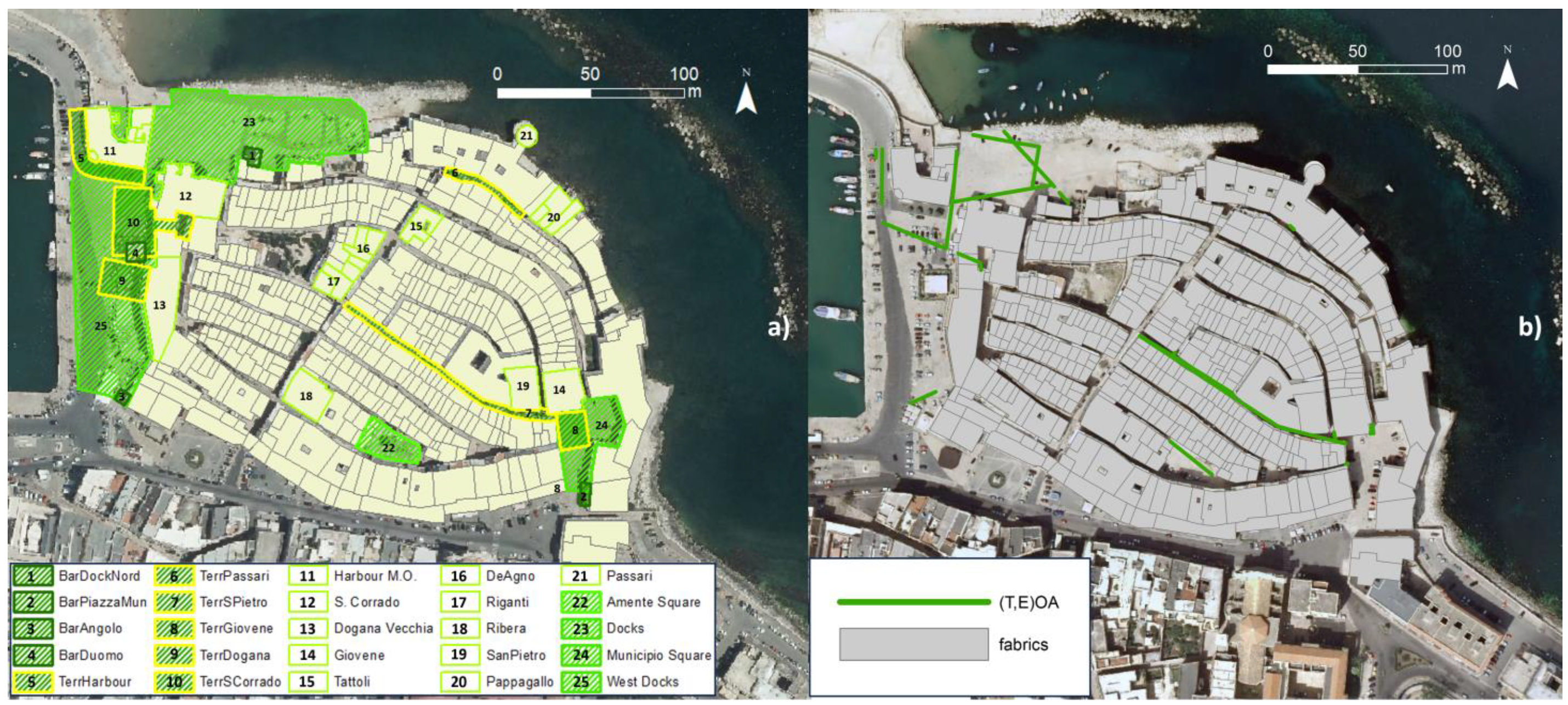
- The presence of representative or symbolic buildings or district areas exposed to the threat of terrorist events [T]. Here, the process is based on the identification of representative buildings or rendezvous, which constitute main touristic/cultural, political, or social “attractors” for perpetrators. Then, as discussed in Cantatore et al. [38], vulnerable OA areas are quantified and identified through two options: (i) the real perimetration of places when OAs are identified as open spaces (i.e., squares) or featured by special attractive uses (i.e., dehors); and (ii) the identification of the associated space of influence in the case of attractive buildings with special uses (e.g., museum, churches, etc.). As discussed in Section 2.2, there are no references about the extension of such spaces. However, for the study, its quantification considers the product between the commercial extension of the building (ACommBuild) and the ratio between the maximum density capacity of people in the buildings (Cb) [pp/m2], as defined by the Italian decree D.M. 03/08/2015, and the maximum density of people when public activities are conducted outside (Cout), as considered for public buildings in the National Ministerial Decree 19/8/1996) (Equation (1)).The equation defines the relation between the maximum extension of the external area that can host people when special activities are supposed to be outside the building. Thus, in this second case, the space of influence is geometrically developed along the building facades with access/es and it completes the map of terroristic vulnerability in OAs [vulnerability map of TOA].ASoI [m2] = ACommBuild [m2] × Cb [pp/m2]/Cout [pp/m2]
As well as the spatial vulnerability of the districts during single ROD concerns, open spaces and streets are examined through the space syntax (SS) analysis to define probability distributions of moving pedestrians inside the historic centre during emergencies [62]. This approach is proposed as a proxy to represent the pattern of human behaviours in space considering [R.H.4], [R.H.5], and [R.H.9] factors though in a derived way. This offers the opportunity to consider physical properties of C-BE in a socio-spatial aspect, combining geometric dimensions with the perception of places by users. Indeed, the space syntax process is based on a topological analysis of the graph representation of the planimetry of the study area to reveal how people tend to use it [49]. This analysis allowed us to correlate the arrangement and the reciprocal relationship of the segments of the road axes in their function of passage paths during the movement inside and out of the historic centre, which does not require a consideration of their staging/safety area capability. Such analysis was carried out with depthmapX software (version 0.5b, https://varoudis.github.io/depthmapX/, accessed on 3 August 2023).The assessment of the spatial vulnerability of single OAs (streets or places) in a linear way using SS maps determines, for each observation point, the possible way of evacuation during the emergency. Thus, the SS analysis becomes the key map to read single-risk maps [EQB; HGB; TOA] as critical ones in emergency scenarios [TOA,E; EQB,E; HGB,E]. In an operative point of view, this is the result of the map-overlapping process, considering the worst conditions in SS analysis, resulting from the statistical assessment of the entire built environment.
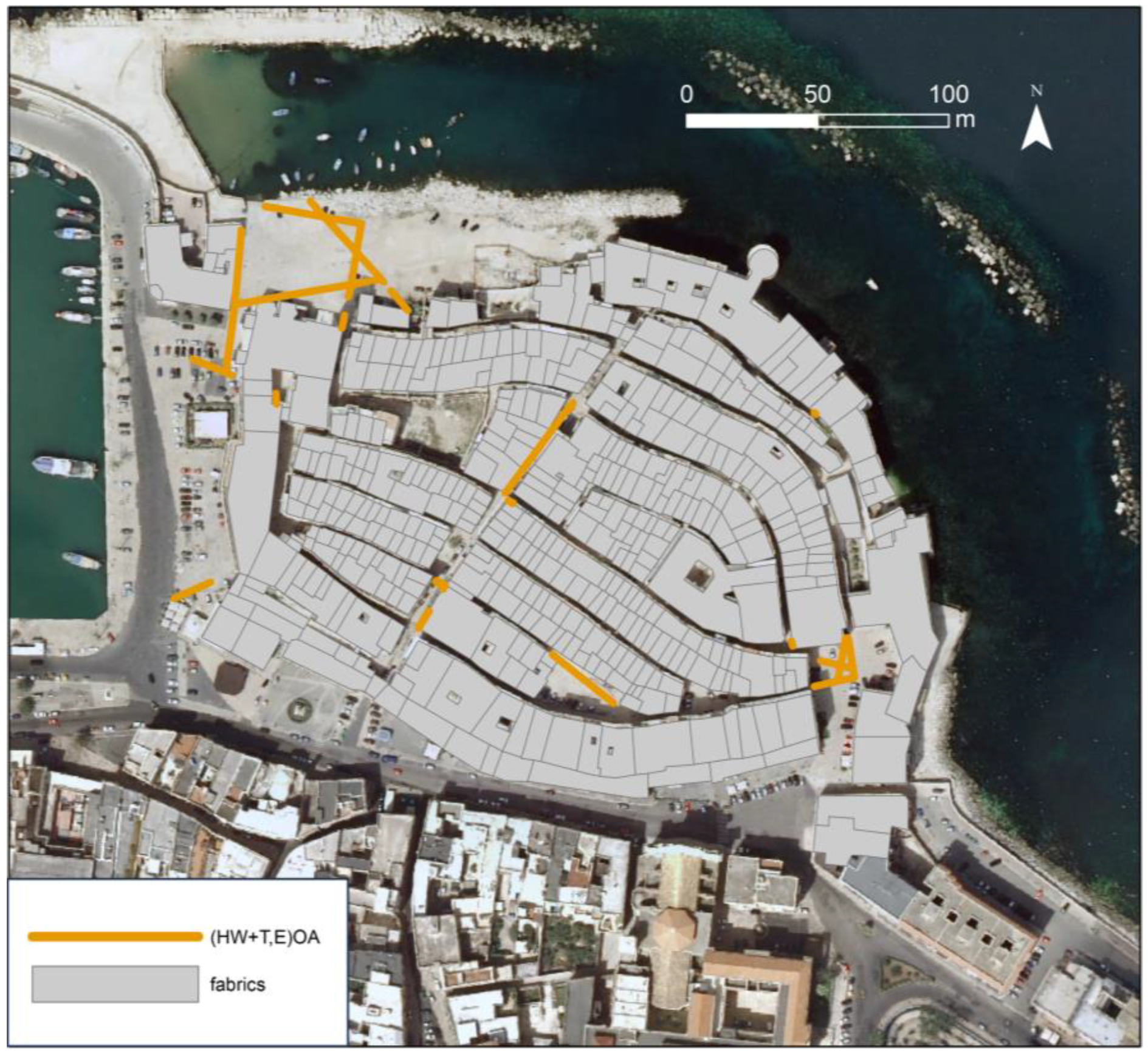
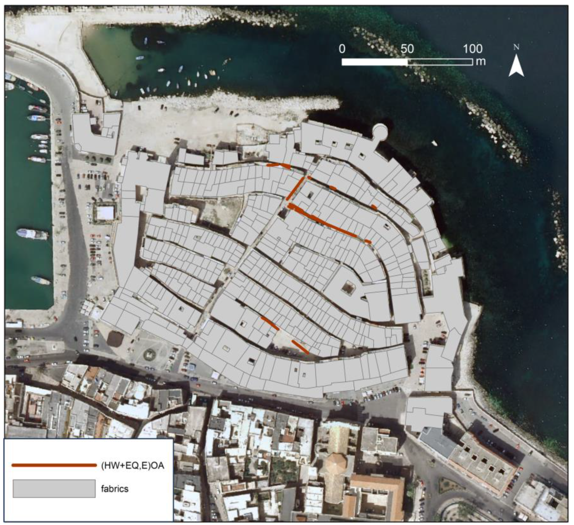
- Finally, the identification of areas with high levels of physical multi-vulnerability in MAH scenarios. Here, external analysis (heatwave and SS) and single-risk maps (hydrological, seismic, and terrorism) are combined in the GIS model and properly detailed in the OA scale, in order to identify areas with high levels of physical multi-vulnerability MAH scenarios. The resulting maps help determine spatial priority classes for vulnerable sub-district areas during potential ROD or SOD events, facilitating the assessment of mitigation solutions that are required to be checked in terms of compatibility with the places. Specifically, a first level of MAH scenarios is discussed in terms of two timely different hazardous events—(HW+T,E)OA; (HW+EQ,E)OA; HW+HG,E)OA—into the emergency phase; the second one overlaps two different sudden events, generated by the different nature of external strengths (natural and man-made), (HW+T,E+EQ,E)OA and (HW+T,E+HG,E)OA.
4. First Results in the Pilot Case of Molfetta
Application to the Case Study
- All the buildings are featured by resistant masonry made of squared blocks and erected according to the compound technique [66] with a few variations of thickness (from 60 to 80 cm). Referring to floors, barrel vaults on the ground floors and wooden planar ceilings represent the common horizontal sub-components of buildings.
- Tower and palace houses are the predominant morpho-typologies of civil construction in the district. These buildings typically have three to four floors, maintaining a relatively constant total height of the block facade. Moreover, the ratios between openings and massive walls along the frontier have similar ranges, varying from 8 to 12%.
- All the buildings are included in systems of long blocks and each buildings contributes to the overall structural resistance of the block; moreover, it is not in contrast with the homogeneity of construction technique [65].
- Referring to the state of conservation, buildings are featured by three main different levels of technological vulnerability strictly related to their use and maintenance conditions. These levels correspond to the previous process of recovery in the district where (i) a good state of conservation is associated with the wider condition of civil structures, (ii) a medium-low one for buildings was already recovered but remained unused, and (iii) a low level for those affected by a critical level of masonry conservation, and lack of roofs and windows, remaining unused. Moreover, for the latter, the compound walls have a serious level of criticality in the inner layer, made of non-coherent materials. On the other hand, special buildings, such as churches, recently underwent interventions for static recovery and are featured by a high level of conservation.
- -
- The projection of the façade when the geometric ratio h/W < 1 (h is the height of buildings and w width of the street); this is the case of Amente Square, which is spatially affected by the global rotation of building facades in its northern part.
- -
- When h/W > 1, a specific area is identified, characterized by the same length as the vulnerable building and a width equivalent to the height of the street. This is the case of all the narrow streets within the analyzed C-BE delimited (by one or two sides) by buildings affected by a critical level of conservation.
- The “Duomo” of San Corrado was built during the XII and XIII centuries along the ancient city walls, with its current appearance being the result of an extension process in 1400–1460. This construction represents the Apulian Romanesque style and is a major religious attraction for tourists and inhabitants.
- The “Dogana Vecchia” palace was built along the city walls in the western part of the ancient city. Its final morphological extension is the result of major intervention during the XVI century when it became the Seminary of Molfetta and adjacent cities, and later, the Customs (XIX century). The actual relevance of the building is reflected by the creation of a luxury resort that attracts wealthy visitors.
- Palace “Giovene” is located at the eastern square of the ancient district. It is an XV century fabric, made with calcareous blocks for two floors, and it is very representative due to its architectural decorations on the main façade. Its categorization for terroristic events depends on the presence of the Town Hall.
- Several other palaces enrich the cultural relevance of the district, including “Tattoli”, “Giovanni De Agno”, “Riganti”, and “Ribera”. However, they are less relevant architectures for the attacks, also due to their private ownership.
- The “San Pietro” church, located in the eastern part of the district, is a baroque construction inserted in the compact ancient core. Its relevance is relatively low due to its position in the district and its minor attractiveness to tourists.
5. Conclusions
Author Contributions
Funding
Institutional Review Board Statement
Informed Consent Statement
Data Availability Statement
Conflicts of Interest
Abbreviations
| ROD | Rapid-Onset Disaster |
| SOD | Slow Onset Disaster |
| MAH | Multi-Asynchronous Hazard |
| C-BE | Cultural Built Environment |
| OA | Outdoor Area |
References
- Koren, D.; Rus, K. The potential of open space for enhancing urban seismic resilience: A literature review. Sustainability 2019, 11, 5942. [Google Scholar] [CrossRef]
- Holling, C.S. Resilience and Stability of Ecological Systems. Annu. Rev. Ecol. Syst. 1973, 4, 1–23. [Google Scholar] [CrossRef]
- UNDRR. Global Assessment Report on Disaster Risk Reduction (GAR); United Nations International Strategy for Disaster Reduction: Geneva, Switzerland, 2019; ISBN 9789210041805. [Google Scholar]
- Vatavali, F. Earthquakes in Europe—National, international and european policy for the prevention and mitigation of seismic disaster. In European Commission Directorate General Environment Unit D3: Civil Protection. 2003. Available online: https://www.academia.edu/31574351/Earthquakes_in_Europe_National_international_and_European_policy_for_the_prevention_and_mitigation_of_seismic_disaster_2003_ (accessed on 3 August 2023).
- Bonnard, C.; Forlati, F.; Scavia, C. Identification and Mitigation of Large Landslide Risks in Europe: Advances in Risk Assessment; CRC Press: London, UK, 2004; ISBN 9780429082085. [Google Scholar] [CrossRef]
- Sonnessa, A.; di Lernia, A.; Nitti, D.O.; Nutricato, R.; Tarantino, E.; Cotecchia, F. Integration of multi-sensor MTInSAR and ground-based geomatic data for the analysis of non-linear displacements affecting the urban area of Chieuti, Italy. Int. J. Appl. Earth Obs. Geoinf. 2023, 117, 103194. [Google Scholar] [CrossRef]
- Revi, A.; Satterthwaite, D.; Aragón-Durand, F.; Corfee-Morlot, J.; Kiunsi, R.; Pelling, M.; Roberts, D.; Solecki, W. Urban Areas in Climate Change 2014: Impacts, Adaptation, and Vulnerability. Part A: Global and Sectoral Aspects. Contribution of Working Group II to the Fifth Assessment Report of the Intergovernmental Panel on Climate Change; Cambridge University Press: Cambridge, UK, 2014; pp. 535–612. [Google Scholar]
- Hochrainer-Stigler, S.; Trogrlić Šakić, R.; Reiter, K.; Ward, P.J.; de Ruiter, M.C.; Duncan, M.J.; Torresan, S.; Ciurean, R.; Mysiak, J.; Stuparu, D.; et al. Toward a framework for systemic multi-hazard and multi-risk assessment and management. iScience 2023, 26, 106736. [Google Scholar] [CrossRef] [PubMed]
- Xiang, Y.; Li, W. Historic district based on AHP method to evaluate the effect of landscape transformation. Appl. Mech. Mater. 2013, 409, 715–718. [Google Scholar] [CrossRef]
- Gargiulo, C.; Sgambati, S.; Zucaro, F. The Analysis of the Urban Open Spaces System for Resilient and Pleasant Historical Districts. In Proceedings of the International Conference on Computational Science and Its Applications, Athens, Greece, 3–6 July 2023; Springer: Cham, Switzerland, 2023; pp. 564–577. [Google Scholar] [CrossRef]
- UNESCO (United Nations Educational, Scientific and Cultural Organization). Recommendation on the Historic Urban Landscape; United Nations Educational, Scientific and Cultural Organization: Paris, France, 2011. [Google Scholar]
- Briz, E.; Garmendia, L.; Quesada-Ganuza, L.; Villaverde, A.; Alvarez, I.; Egusquiza, A. Prioritization Methodology for Resilience Enhancement of Historic Areas Facing Climate Change-Related Hazards. Adv. Struct. Mater. 2022, 179, 3–14. [Google Scholar]
- García-Hernández, M.; la Calle-Vaquero, D.; Yubero, C. Cultural heritage and urban tourism: Historic city centres under pressure. Sustainability 2017, 9, 1346. [Google Scholar] [CrossRef]
- Rey-Pérez, J.; Avellán, D.V. Towards the Implementation of the Historic Urban Landscape Approach in the Guayaquil Waterfront (Ecuador): A Scoping Case Study. Hist. Environ. Policy Pract. 2018, 9, 349–375. [Google Scholar] [CrossRef]
- Colavitti, A.M.; Usai, A. Applying the HUL approach to walled towns of Mediterranean seaport cities: Lessons and guidelines through the experience of four UNESCO walled towns. J. Place Manag. Dev. 2019, 12, 338–364. [Google Scholar] [CrossRef]
- El-bastawissi, I.Y.; Raslan, R.; Mohsen, H.; Zeayter, H. Conservation of Beirut’s Urban Heritage Values Through the Historic Urban Landscape Approach. Urban Plan. 2022, 7, 101–115. [Google Scholar] [CrossRef]
- Sonnessa, A.; Cantatore, E.; Esposito, D.; Fiorito, F. A Multidisciplinary Approach for Multi-risk Analysis and Monitoring of Influence of SODs and RODs on Historic Centres: The ResCUDE Project. In Lecture Notes in Computer Science, Proceedings of the Computational Science and Its Applications–ICCSA 2020: 20th International Conference, Cagliari, Italy, 1–4 July 2020; Springer International Publishing: Cham, Switzerland, 2020; Volume 12252 LNCS. [Google Scholar]
- Cardona, O.D.; Van Aalst, M.K.; Birkmann, J.; Fordham, M.; Mc Gregor, G.; Rosa, P.; Pulwarty, R.S.; Schipper, E.L.F.; Sinh, B.T.; Décamps, H. Determinants of risk: Exposure and vulnerability. In Managing the Risks of Extreme Events and Disasters to Advance Climate Change Adaptation: Special Report of the Intergovernmental Panel on Climate Change; Cambridge University Press: Cambridge, UK, 2012; pp. 65–108. [Google Scholar]
- EM-DAT Disaster Classification. Available online: www.emdat.be/classification (accessed on 3 August 2023).
- Protezione Civile Classificazione Sismica del Territorio Italiano-Aggiornato al 1 Dicembre 2020. Available online: http://www.protezionecivile.gov.it/documents/20182/0/classificazione+sismica+1+dicembre+2020/ba1c5d77-77de-4fcf-9f4cAdd895587f4ed5 (accessed on 3 August 2023).
- Autorità di Bacino della Puglia. Carta Idrogeomorfologica Della Regione Puglia. Available online: https://webapps.sit.puglia.it/freewebapps/Idrogeomorfologia/index.html (accessed on 3 August 2023).
- Loiodice, I. Development of tourism in Apulia region and training of tour operators. In Cultural Tourism in a Digital Era; Springer: Berlin/Heidelberg, Germany, 2015; pp. 385–396. [Google Scholar]
- Field, C.B. Managing the Risks of Extreme Events and Disasters to Advance Climate Change Adaptation: Special Report of the Intergovernmental Panel on Climate Change; Cambridge University Press: Cambridge, UK, 2012; ISBN 1107025060. [Google Scholar]
- Coppola, E.; Giorgi, F. An assessment of temperature and precipitation change projections over Italy from recent global and regional climate model simulations. Int. J. Climatol. A J. R. Meteorol. Soc. 2010, 32, 11–32. [Google Scholar] [CrossRef]
- Moscatelli, M.; Albarello, D.; Scarascia Mugnozza, G.; Dolce, M. The Italian approach to seismic microzonation. Bull. Earthq. Eng. 2020, 18, 5425–5440. [Google Scholar] [CrossRef]
- Woo, G. Understanding the Principles of Terrorism Risk Modeling from Charlie Hebdo Attack in Paris. Def. Against Terror. Rev. 2015, 7, 33–46. [Google Scholar]
- Koppen, W. Das Geographische System der Klimat; Handbuch der Klimatologie; Gebrueder Borntraeger: Berlin, Germany, 1936; p. 46. [Google Scholar]
- Zuccaro, G.; Dolce, M.; De Gregorio, D.; Speranza, E.; Moroni, C. La Scheda Cartis Per La Caratterizzazione Tipologico- Strutturale Dei Comparti Urbani Costituiti Da Edifici Ordinari. Valutazione dell’esposizione in analisi di rischio sismico. Proc. GNGTS 2015, 2016, 281–287. [Google Scholar]
- Lagomarsino, S.; Giovinazzi, S. Macroseismic and mechanical models for the vulnerability assessment of current buildings. Bull. Earthq. Eng. 2006, 4, 415–443. [Google Scholar] [CrossRef]
- Aguado, J.L.P.; Ferreira, T.M.; Lourenço, P.B. The Use of a Large-Scale Seismic Vulnerability Assessment Approach for Masonry Façade Walls as an Effective Tool for Evaluating, Managing and Mitigating Seismic Risk in Historical Centers. Int. J. Archit. Herit. 2018, 12, 1259–1275. [Google Scholar] [CrossRef]
- Formisano, A.; Florio, G.; Landolfo, R.; Mazzolani, F.M. Numerical calibration of an easy method for seismic behaviour assessment on large scale of masonry building aggregates. Adv. Eng. Softw. 2015, 80, 116–138. [Google Scholar] [CrossRef]
- Bernabei, L.; Mochi, G.; Bernardini, G.; Quagliarini, E. Seismic risk of Open Spaces in Historic Built Environments: A matrix-based approach for emergency management and disaster response. Int. J. Disaster Risk Reduct. 2021, 65, 102552. [Google Scholar] [CrossRef]
- Godfrey, A.; Ciurean, R.L.; Van Westen, C.J.; Kingma, N.C.; Glade, T. Assessing vulnerability of buildings to hydro-meteorological hazards using an expert based approach–An application in Nehoiu Valley, Romania. Int. J. Disaster Risk Reduct. 2015, 13, 229–241. [Google Scholar] [CrossRef]
- Stephenson, V.; D’ayala, D. A new approach to flood vulnerability assessment for historic buildings in England. Nat. Hazards Earth Syst. Sci. 2014, 14, 1035–1048. [Google Scholar] [CrossRef]
- Custer, R.; Nishijima, K. Flood vulnerability assessment of residential buildings by explicit damage process modelling. Nat. Hazards 2015, 78, 461–496. [Google Scholar] [CrossRef]
- Singh, A.; Kanungo, D.P.; Pal, S. Physical vulnerability assessment of buildings exposed to landslides in India. Nat. Hazards 2019, 96, 753–790. [Google Scholar] [CrossRef]
- Quagliarini, E.; Fatiguso, F.; Lucesoli, M.; Bernardini, G.; Cantatore, E. Risk reduction strategies against terrorist acts in urban built environments: Towards sustainable and human-centred challenges. Sustainability 2021, 13, 901. [Google Scholar] [CrossRef]
- Cantatore, E.; Quagliarini, E.; Fatiguso, F. European Cities Prone to Terrorist Threats: Phenomenological Analysis of Historical Events towards Risk Matrices and an Early Parameterization of Urban Built Environment Outdoor Areas. Sustainability 2022, 14, 12301. [Google Scholar] [CrossRef]
- Li Piani, T. Progettazione strutturale e funzione sociale dello spazio (quale) vulnerabilità e soluzione al terrorismo urbano. Secur. Terror. Soc. (Sicur. Terror. Soc.) 2018, 8, 7–15. [Google Scholar]
- Babu, N.R.; Subramanian, C.V. Perception of Fire safety evacuation design towards Fire Disaster in core towns of southern region of India. Disaster Adv. 2023, 16, 16–27. [Google Scholar]
- Silva, D.; Rodrigues, H.; Ferreira, T.M. Assessment and Mitigation of the Fire Vulnerability and Risk in the Historic City Centre of Aveiro, Portugal. Fire 2022, 5, 173. [Google Scholar] [CrossRef]
- Cantatore, E.; Fatiguso, F. An energy-resilient retrofit methodology to climate change for historic districts. Application in the mediterranean area. Sustainability 2021, 13, 1422. [Google Scholar] [CrossRef]
- Oke, T.R. Canyon geometry and the nocturnal urban heat island: Comparison of scale model and field observations. Int. J. Climatol. 1981, 1, 237–254. [Google Scholar] [CrossRef]
- Hegazi, Y.S.; Tahoon, D.; Abdel-Fattah, N.A.; El-Alfi, M.F. Socio-spatial vulnerability assessment of heritage buildings through using space syntax. Heliyon 2022, 8, e09133. [Google Scholar] [CrossRef]
- Kuligowski, E.D.; Gwynne, S.M.V. The need for behavioral theory in evacuation modeling. In Pedestrian and Evacuation Dynamics 2008; Springer: Berlin/Heidelberg, Germany, 2010; pp. 721–732. [Google Scholar]
- Hofinger, G.; Zinke, R.; Künzer, L. Human factors in evacuation simulation, planning, and guidance. Transp. Res. Procedia 2014, 2, 603–611. [Google Scholar] [CrossRef]
- Kinateder, M.T.; Kuligowski, E.D.; Reneke, P.A.; Peacock, R.D. Risk perception in fire evacuation behavior revisited: Definitions, related concepts, and empirical evidence. Fire Sci. Rev. 2015, 4, 1. [Google Scholar] [CrossRef] [PubMed]
- Adam, C.; Gaudou, B. Modelling human behaviours in disasters from interviews: Application to Melbourne bushfires. J. Artif. Soc. Soc. Simul. 2017, 20, 12. [Google Scholar] [CrossRef]
- Wang, Y.; Kyriakidis, M.; Dang, V.N. Incorporating human factors in emergency evacuation–an overview of behavioral factors and models. Int. J. Disaster Risk Reduct. 2021, 60, 102254. [Google Scholar] [CrossRef]
- Alonso, L.; Renard, F. A comparative study of the physiological and socio-economic vulnerabilities to heat waves of the population of the Metropolis of Lyon (France) in a climate change context. Int. J. Environ. Res. Public Health 2020, 17, 1004. [Google Scholar] [CrossRef] [PubMed]
- Loughnan, M.E.; Tapper, N.J.; Lynch, K.; McInnes, J.; Phan, T. A Spatial Vulnerability Analysis of Urban Populations during Extreme Heat Events in Australian Capital Cities; National Climate Change Adaptation Research Facility: Southport, Australia, 2012; ISBN 1921609737. [Google Scholar]
- Cutter, S.L.; Boruff, B.J.; Shirley, W.L. Social vulnerability to environmental hazards. In Hazards Vulnerability and Environmental Justice; Routledge: London, UK, 2012; pp. 143–160. ISBN 1849771545. [Google Scholar]
- Pescaroli, G.; Alexander, D. A definition of cascading disasters and cascading effects: Going beyond the “toppling dominos” metaphor. Planet@ Risk 2015, 3, 58–67. [Google Scholar]
- Johnston, D.; Becker, J.; McClure, J.; Paton, D.; McBride, S.; Wright, K.; Leonard, G.; Hughes, M. Community understanding of, and preparedness for, earthquake and tsunami risk in Wellington, New Zealand. In Cities at Risk: Living with Perils in the 21st Century; Springer: Berlin/Heidelberg, Germany, 2013; pp. 131–148. [Google Scholar]
- Chan, J.C. The role of social media in crisis preparedness, response and recovery. Public Relat. Res. 2014, 8, 279–295. [Google Scholar]
- Paton, D.; Johnston, D. Disasters and communities: Vulnerability, resilience and preparedness. Disaster Prev. Manag. An Int. J. 2001, 10, 270–277. [Google Scholar] [CrossRef]
- Cutter, S.L.; Boruff, B.J.; Shirley, W.L. Social vulnerability to environmental hazards. Social. Sci. Q. 2003, 84, 242–261. [Google Scholar] [CrossRef]
- Aldrich, D.P.; Meyer, M.A. Social Capital and Community Resilience. Am. Behav. Sci. 2015, 59, 254–269. [Google Scholar] [CrossRef]
- Lovreglio, R.; Fonzone, A.; Dell’Olio, L.; Borri, D. A study of herding behaviour in exit choice during emergencies based on random utility theory. Saf. Sci. 2016, 82, 421–431. [Google Scholar] [CrossRef]
- Esposito, D.; Cantatore, E.; Sonnessa, A. A Multi Risk Analysis for the Planning, Management and Retrofit of Cultural Heritage in Historic Urban Districts. In Proceedings of the International Conference on Innovation in Urban and Regional Planning, Catania, Italy, 8–10 September 2021; Springer International Publishing: Cham, Switzerland, 2021; p. 571. [Google Scholar]
- Puglia, S.I.T. Cartografia Tematica. Available online: http://www.sit.puglia.it/portal/portale_cartografie_tecniche_tematiche/ViewMenuPortletWindow?action=2&idsezione=322&nomesezione=Cartografie%20Tecniche%20e%20Tematiche&paginacms=/contents/schede-html/carte.html (accessed on 3 August 2023).
- Cutini, V.; De Falco, A.; Giuliani, F. Urban Grid and Seismic Prevention-A Configurational Approach to The Emergency Management of Italian Historic Centres. In Proceedings of the 12SSS 12th International Space Syntax Symposium, Beijing, China, 8–13 July 2019. [Google Scholar]
- Esposito, D.; Santoro, S.; Camarda, D. Agent-Based Analysis of Urban Spaces Using Space Syntax and Spatial Cognition Approaches: A Case Study in Bari, Italy. Sustainability 2020, 12, 4625. [Google Scholar] [CrossRef]
- Yamu, C.; Van Nes, A.; Garau, C. Bill Hillier’s legacy: Space syntax—A synopsis of basic concepts, measures, and empirical application. Sustainability 2021, 13, 3394. [Google Scholar] [CrossRef]
- Quagliarini, E.; Lucesoli, M.; Bernardini, G. Rapid tools for assessing building heritage’s seismic vulnerability: A preliminary reliability analysis. J. Cult. Herit. 2019, 39, 130–139. [Google Scholar] [CrossRef]
- De Tommasi, G.; Fatiguso, F.; De Fino, M. Riqualificazione Energetica del Patrimonio Edilizio Storico. Studi per il Geocluster dei Borghi Antichi in Area Mediterranea; EdicomEdizioni: Monfalcone, Italy, 2019; ISBN 9788896386811. [Google Scholar]
- Regione Puglia CartApulia. Available online: http://cartapulia.it/ (accessed on 3 August 2023).
- Cutini, V.; Di Pinto, V. Configurational disaster risk reduction. La struttura relazionale dello spazio urbano può salvare la città del futuro? In Proceedings of the Conferenza Nazionale della SIU-Società Italiana degli Urbanisti, Turin, Italy, 15–16 June 2021; Planum Publisher: Prague, Czech Republic, 2021; Volume 2, pp. 626–632. [Google Scholar]
- De Fino, M.; Bruno, S.; Fatiguso, F. Dissemination, assessment and management of historic buildings by thematic virtual tours and 3D models. Virtual Archaeol. Rev. 2022, 13, 88–102. [Google Scholar] [CrossRef]
- D’Amico, A.; Bernardini, G.; Lovreglio, R.; Quagliarini, E. A non-immersive virtual reality serious game application for flood safety training. Int. J. Disaster Risk Reduct. 2023, 96, 103940. [Google Scholar] [CrossRef]
- Chiabrando, F.; Colucci, E.; Lingua, A.; Matrone, F.; Noardo, F.; Spanò, A. A European interoperable database (EID) to increase resilience of cultural heritage. Int. Arch. Photogramm. Remote Sens. Spat. Inf. Sci. 2018, 42, 151–158. [Google Scholar] [CrossRef]
- Kalbani, K.A.; Rahman, A.A. 3D city model for monitoring flash flood risks in Salalah, Oman. Int. J. Eng. Geosci. 2022, 7, 17–23. [Google Scholar] [CrossRef]
- Gandini, A.; Quesada, L.; Prieto, I.; Garmendia, L. Climate change risk assessment: A holistic multi-stakeholder methodology for the sustainable development of cities. Sustain. Cities Soc. 2021, 65, 102641. [Google Scholar] [CrossRef]
- Mol, J.M.; Wouter Botzen, W.J.; Blasch, J.E. After the virtual flood: Risk perceptions and flood preparedness after virtual reality risk communication. Judgm. Decis. Mak. 2022, 17, 189–214. [Google Scholar] [CrossRef]
- Ouyang, H.; Tang, X.; Zhang, R.; Baklanov, A.; Brasseur, G.; Kumar, R.; Han, Q.; Luo, Y. Resilience Building and Collaborative Governance for Climate Change Adaptation in Response to a New State of More Frequent and Intense Extreme Weather Events. Int. J. Disaster Risk Sci. 2023, 14, 162–169. [Google Scholar] [CrossRef]


| SOD | H | V | E | ROD | H | V | E |
|---|---|---|---|---|---|---|---|
| Natural Environment Parameters | Natural Environment Parameters | ||||||
| [S.E.1] Climate | x | [R.E.1] Geo-morphological features (intrinsic or amplifying) of the terrain | x | ||||
| [S.E.2] Environmental boundary conditions | x | ||||||
| Built Environment Parameters | Built environment Parameters | ||||||
| [S.B.1] Morpho-typological features of district or blocks | p | [R.B.1] Morphological asset of the district | p | ||||
| [S.B.2] Material, constructive and technological features of buildings | p | [R.B.2] Material, constructive and technological features of buildings | p | ||||
| [S.B.3] Geometric and constructive features of outdoor areas | p | [R.B.3] Geometric and constructive features of outdoor areas (boundaries) | p | ||||
| [S.B.4] Geometric data of buildings | p | [R.B.4] Geometric data of buildings and components | p | ||||
| [R.B.5] Type of accesses for geometric and protective features | x | ||||||
| [R.B.6] State of conservation of buildings | p | ||||||
| [R.B.7] Presence of special buildings | p | ||||||
| [R.B.8] Presence of obstacles and urban furniture | x | ||||||
| [S.B.5] n. of buildings and places exposed to overheating | x | [R.B.9] n. of unusable buildings after critical event | x | ||||
| Socio-spatial Parameters | Socio-spatial Parameters | ||||||
| [S.H.1] Timely availability and accessibility of risk-related and lifesaving information | s | [R.H.1] Timely availability and accessibility of risk-related and lifesaving information | s | ||||
| [S.H.2] Socio-demographic and socio-economic profile of the affected population | s | [R.H.2] Socio-demographic and socio-economic profile of the affected population | s | ||||
| [S.H.3] Purpose and actual use of land, buildings, and open spaces | s | [R.H.3] Purpose and actual use of land, buildings, and open spaces | s | ||||
| s | [R.H.4] Social relationships between agents and attachment to places | p/s | |||||
| s | [R.H.5] Dynamic spatial interactions between agents and the built environment | p/s | |||||
| s | [R.H.6] Roles and responsibilities for each agent | s | |||||
| [S.H.4] Agents’ direct or indirect knowledge of specific risk dynamics | s | [R.H.7] Agents’ direct or indirect knowledge of specific risk dynamics | s | ||||
| [S.H.5] Permanent or temporary impairments, abilities/disabilities, and health conditions | s | [R.H.8] Permanent or temporary impairments, abilities/disabilities, and health conditions | s | ||||
| [S.H.6] Risk perception and reaction to danger and disruption | s | [R.H.9] Risk perception and reaction to danger and disruption | p/s | ||||
| [S.H.7] Number of people exposed to SOD | s | x | [R.H.10] Number of people exposed to ROD | s | x |
| SOD | ROD |
|---|---|
| Built Environment Parameters | Built Environment Parameters |
| [S.B.1a_Molf] | [S.B.1a_Molf] |
| Continuous and homogeneous district asset with long blocks, with narrows, parallel and flat streets | Continuous and homogeneous district asset with long blocks, with narrows, parallel and flat streets |
| [S.B_Molf] | [S.B.1b_Molf] |
| Residential buildings featured by vertical development (3–4 floors), organized in double rows (NNW—SSE axis) | Residential buildings featured by vertical development (3–4 floors), organized in double rows (NNW—SSE axis) |
| [S.B.2a_Molf] | [S.B.2a_Molf] |
| Massive masonries in squared and calcareous block, flat roofs (wooden mostly) with any thermal layer, one window for each floor | Massive masonries in squared and calcareous block, flat roofs (wooden mostly), constructive technologies homogeneous and continuous in the block, one window for floor |
| [S.B.2b_Molf] | [S.B.2b_Molf] |
| Clear calcarenitic for wall surfaces, bituminous/cotto tiles or calcareous paving for roofs, wooden windows | Clear calcarenitic for wall surfaces, bituminous/cotto tiles or calcareous paving for roofs, wooden windows |
| [S.B.3_Molf] | [S.B.3_Molf] |
| Clear, smooth and semi-shiny calcarenitic paving (“chiancarelle”), few green areas and two paved squares | Clear, smooth and semi-shiny calcarenitic “chiancarelle” for street, few garden areas and two open paved squares |
| [R.B.4_Molf] | |
| Limited number of accesses to the districts, referred to the ancient City Gates with limitation of vehicular transit | |
| [R.B.5_Molf] | |
| Presence of buildings with medium-low State of conservation (static problems related) | |
| [R.B.6_Molf] | |
| Presence of special buildings (Cathedral, churches, coffee bar, Master Harbour Office di Porto) | |
| Socio-spatial Parameters | Socio-spatial Parameters |
| [R.H.4_Molf] Social relationships between agents and attachment to places | |
| [R.H.5_Molf] Dynamic spatial interactions between agents and the built environment | |
| [R.H.9_Molf] Risk perception and reaction to danger and disruption |
| Use | Internal Area [m2] | n Floors | Crowding Rate (pers/m2) | Max Outer Density [pers/m2] | ASoI [m2] | |
|---|---|---|---|---|---|---|
| Cultural buildings | ||||||
| Capitaneria | Public use/military use | 1480 | 1 | 0.4 | 1.2 | 493.35 |
| Dogana | Touristic/residential | 751 | 4 | 0.4 | 1.2 | 1001.35 |
| Giovene | Public offices | 452 | 2 | 0.4 | 1.2 | 301.35 |
| Pappagallo | Private residential | excluded | ||||
| Ribera | Private residential | excluded | ||||
| Riganti-De Agno | Private residential | excluded | ||||
| San Corrado | Church | 813.59 | 1 | 1.2 | 1.2 | 813.59 |
| San Pietro | Church | 358 | 1 | 1.2 | 1.2 | 358.00 |
| Tattoli | Private residential | excluded | ||||
| Torrione Passari | Exposition, public use | 94.67 | 2 | 1.2 | 1.2 | 189.33 |
| Attractive Use | ||||||
| Bar Municipio Square | Commercial | 67 | ||||
| Bar 1 Duomo | Commercial | 124 | ||||
| Bar 2 Duomo | Commercial | 228 | ||||
| Bar Dock 1 | Commercial | 25 | ||||
| Open Spaces | ||||||
| Amente Square | Public use | 458 | ||||
| Municipio Square | Public use | 1135 | ||||
| Dock 1 (west) | Public use | 3441 | ||||
| Dock 2 (north) | Public use | 4421 | ||||
Disclaimer/Publisher’s Note: The statements, opinions and data contained in all publications are solely those of the individual author(s) and contributor(s) and not of MDPI and/or the editor(s). MDPI and/or the editor(s) disclaim responsibility for any injury to people or property resulting from any ideas, methods, instructions or products referred to in the content. |
© 2023 by the authors. Licensee MDPI, Basel, Switzerland. This article is an open access article distributed under the terms and conditions of the Creative Commons Attribution (CC BY) license (https://creativecommons.org/licenses/by/4.0/).
Share and Cite
Cantatore, E.; Esposito, D.; Sonnessa, A. Mapping the Multi-Vulnerabilities of Outdoor Places to Enhance the Resilience of Historic Urban Districts: The Case of the Apulian Region Exposed to Slow and Rapid-Onset Disasters. Sustainability 2023, 15, 14248. https://doi.org/10.3390/su151914248
Cantatore E, Esposito D, Sonnessa A. Mapping the Multi-Vulnerabilities of Outdoor Places to Enhance the Resilience of Historic Urban Districts: The Case of the Apulian Region Exposed to Slow and Rapid-Onset Disasters. Sustainability. 2023; 15(19):14248. https://doi.org/10.3390/su151914248
Chicago/Turabian StyleCantatore, Elena, Dario Esposito, and Alberico Sonnessa. 2023. "Mapping the Multi-Vulnerabilities of Outdoor Places to Enhance the Resilience of Historic Urban Districts: The Case of the Apulian Region Exposed to Slow and Rapid-Onset Disasters" Sustainability 15, no. 19: 14248. https://doi.org/10.3390/su151914248
APA StyleCantatore, E., Esposito, D., & Sonnessa, A. (2023). Mapping the Multi-Vulnerabilities of Outdoor Places to Enhance the Resilience of Historic Urban Districts: The Case of the Apulian Region Exposed to Slow and Rapid-Onset Disasters. Sustainability, 15(19), 14248. https://doi.org/10.3390/su151914248