Abstract
Evapotranspiration (ET) is a key indicator of arid and semi-arid ecosystem processes and hydrological cycles. The study of basin-scale ET characteristics and drivers can provide a better understanding of regional water balance and energy cycles. This study used the Pixel Information Expert Engine platform based on MODIS (MOD16A2) data to extract the separate spatial and temporal characteristics of interannual and seasonal ET in the Urumqi River Basin in Xinjiang, China, over a 20-year period, from 2000 to 2020, and to analyze the influence of land-use data and altitude on ET in the basin. The average interannual ET in the watershed has had an increasing trend over the past two decades, varying from 126.57 mm to 247.66 mm, with the maximum ET in July and the minimum in December. On the seasonal scale, the ET trend is greatest in summer, followed by spring, and it is the least in winter. Spatially, the surface ET in the Urumqi River Basin is generally high in the upstream area and low in the downstream area, with the average multi-year ET throughout the basin falling within the range of 22.74–479.33 mm. The average ET for each type of land use showed that forest land had the highest ET and unused land the lowest. Analysis found that the effect of altitude on ET was more pronounced, with a significant increase in ET as altitude increases. Analysis of the drivers of ET change from 2000 to 2020 using the Optimal Parameters-based Geographical Detector model (OPGD) showed that the natural factors that had the greatest influence were, in descending order, temperature > vegetation cover > precipitation. Among the interacting factors, vegetation index with temperature, elevation, and precipitation and land use with elevation had a relatively greater influence on ET in the basin, and the effects of interacting factors were all greater than those of single factors.
1. Introduction
Evapotranspiration (ET), as an important component of energy transfer [1], links the hydrosphere, atmosphere, and biosphere. It is a key component of water transfer and transformation in the soil–plant–atmosphere continuum [2,3]. Approximately 60% of precipitation on the surface of the planet is returned to the atmosphere through ET, while in arid regions this value can reach 90% [4]. In the context of global warming, the degree of drought in arid zones continues to increase, and ecosystems are in danger of severe degradation [5]. Estimating ET values in arid zones and fully analyzing the spatiotemporal distribution and driver factors of ET changes in river basins are therefore important for understanding the water cycle of the region, improving resource utilization, and ensuring the ecological health of the basin [6,7,8].
Traditional methods such as pan evaporation, lysimeters, and flux points can obtain single-point high-precision ET information [9,10], but they are also limited by the heterogeneity of the number of observatories and their spatial distribution [11]. As remote sensing continues to evolve, estimates of ET at different regional scales and over long periods have provided a robust database for research [12,13]. Among these data sources, MOD16 products have been proven to have an accuracy of 80–90% in ET estimation and are widely used in ET studies at different scales [14,15,16]. The MOD16 algorithm is based on the Penman–Monteith equation, which classifies the soil surface into the saturated moist surface and wet surface, and it converts stomatal conductance into canopy conductance through the leaf area index to calculate the vegetation ET. At the same time, it parameterizes the impedance for different surface cover types, which improves the accuracy of remote sensing inversion for ET of the specific sub-surface, and it can better solve the problem of ET monitoring over longer time scales.
In arid zones, the excessive increase in ET has led to ecological problems such as drought, land degradation, desertification, and dust storms [17,18,19]. It has been shown that the spatial and temporal distribution characteristics of ET vary significantly, owing to regional and ecological differences, and that different regions show different ET trends [20,21,22]. To explore the reasons for these changes, scientists have studied the factors driving ET in different regions, revealing that it can generally be attributed to the effects of land use, altitude, moisture, temperature, and vegetation growth conditions [23,24,25]. Gu et al. [26] found that land use plays a leading role in the change in ET in the Yellow River Basin. Ma et al. [27] studied the Shule River Basin by using the daily data of 10 meteorological stations over the past 40 years (1984–2019) and concluded that warming is the main reason behind the constant increase in ET. Ribolzi et al. [28] argued that the effect of vegetation change on ET in the Hai He River Basin is significantly greater than the direct effect of climate change. However, climate factors have a strong impact on ET indirectly through vegetation. In summary, because of regional and ecological differences, different regions have different characteristics of ET changes and significant differences in their main control factors [29,30,31]. The watershed itself is topographically complex, and in areas with more complex topography, the ET variation characteristics of different factors are worthy of deeper exploration [32]. Therefore, for arid zone watersheds that are affected by both climate change and strong human activities, it is necessary to quantitatively analyze the mechanisms driving the effects of natural and anthropogenic factors on the evolution of spatial and temporal changes in ET [33]. This knowledge can provide a basis for the sustainable development of hydrological ecosystems and the scientific management of water resources in arid and semi-arid watersheds.
In the Urumqi River Basin, which is located in Urumqi City, Xinjiang Uygur Autonomous Region, China, in the middle of the northern slopes of the Tianshan Mountains, at the southern edge of the Junggar Basin, ET has considerable influence on water resource utilization and the ecological security of not only Urumqi but also other surrounding counties and cities. The current characteristics and factors influencing ET, from the upper mountainous regions where human activity is relatively low, to the middle reaches where urban expansion is concentrated, and then to the lower reaches where agricultural activity is concentrated, are unclear [34,35]. Hence, the objectives of this research were to determine (1) the spatial, temporal, and seasonal variations of vegetation ET in the Urumqi River Basin between 2000 and 2020, (2) the impact of land use and topography on ET, and (3) the extent to which natural and anthropogenic factors such as meteorology, topography, and human activities affect ET. This allowed a quantitative analysis of the evolution mechanism of spatial and temporal variation of ET and its driving factors. This work aims to provide a basis for the sustainable development of the hydrological ecosystem and scientific management of water resources in the Urumqi River Basin.
2. Materials and Methods
2.1. Study Area
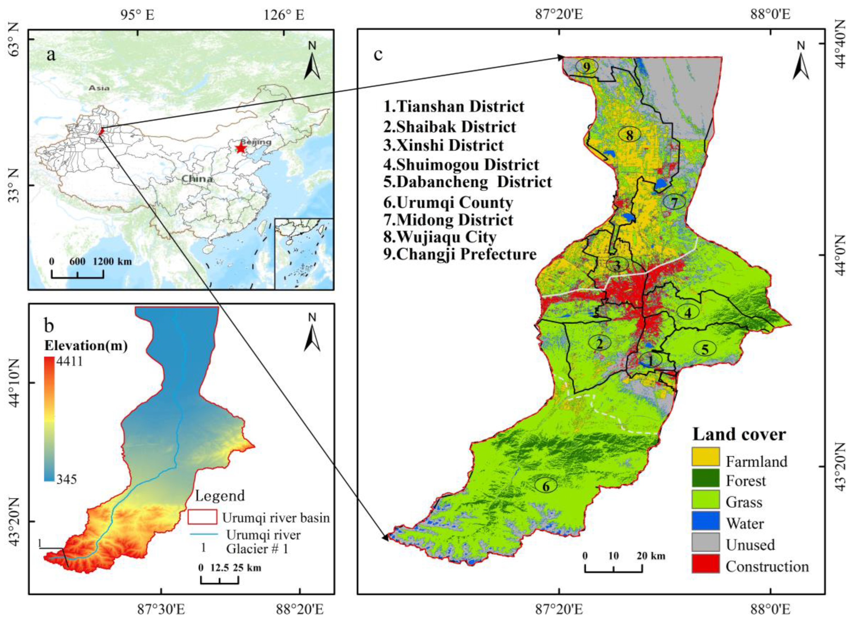
Urumqi River Basin is located in the hinterland of Asia and Europe, in the middle of the northern slopes of the Tianshan Mountains and at the southern edge of the Jung gar Basin, between 86°45′ E and 87°56′ E longitude and 43°00′ N and 44°07′ N latitude (Figure 1). The research site covered an area of 6645 km2, with complex landforms. The highest elevation in the south is 4411 m and the lowest in the north is 345 m, and the terrain is a succession of mountains, oases, and desert. It is a typical microcosm of an arid region, with a ‘mountain–oasis–desert’ composite ecosystem. The Urumqi River is an inland river that originates from Glacier 1 and crosses Tianshan District, Shaibak District, and New Urban District of Urumqi, before entering Wujiaqu City and ultimately flowing into Lake Dongdaohaizi. The river’s total length is 214 km, and it is recharged by a mixture of meltwater from ice, rainfall, and groundwater. The interannual changes in the runoff of Urumqi River are relatively gentle, with runoff across the year being mainly concentrated from June to August. The runoff from June to September has been measured as 190 million cubic meters, with an annual runoff of 237 million cubic meters. The basin is characterized by large temperature differences, low precipitation, long winters, and large annual differences in temperature. The average annual temperature is 5.7 °C; the average annual precipitation ranges from 70 to 500 mm and is 100 mm in the northern desert area [36]. Land use in the study area consists of six types: cultivated land (farmland), forest, grassland, water body, construction land, and unused land.
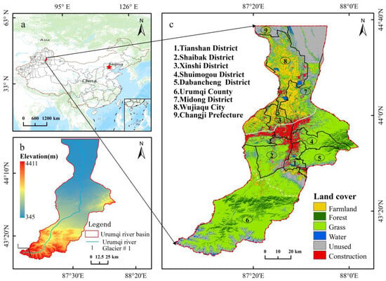
Figure 1.
(a) The Urumqi River Basin in China. (b) Study area elevation. (c) Land-use types in the study area.
2.2. Data Sources
MOD16A2 data from 2000 to 2020 were selected as the main data source to analyze the spatial and temporal variation of ET in the study area for the past 20 years. Land use, elevation, slope, slope direction, vegetation index, temperature, and precipitation were selected as factors affecting ET based on the characteristics of this study area and previous research on factors affecting ET [37,38]. The data for each factor of influence were uniformly resampled to 500 m according to the spatial resolution of the ET data.
2.2.1. ET Data
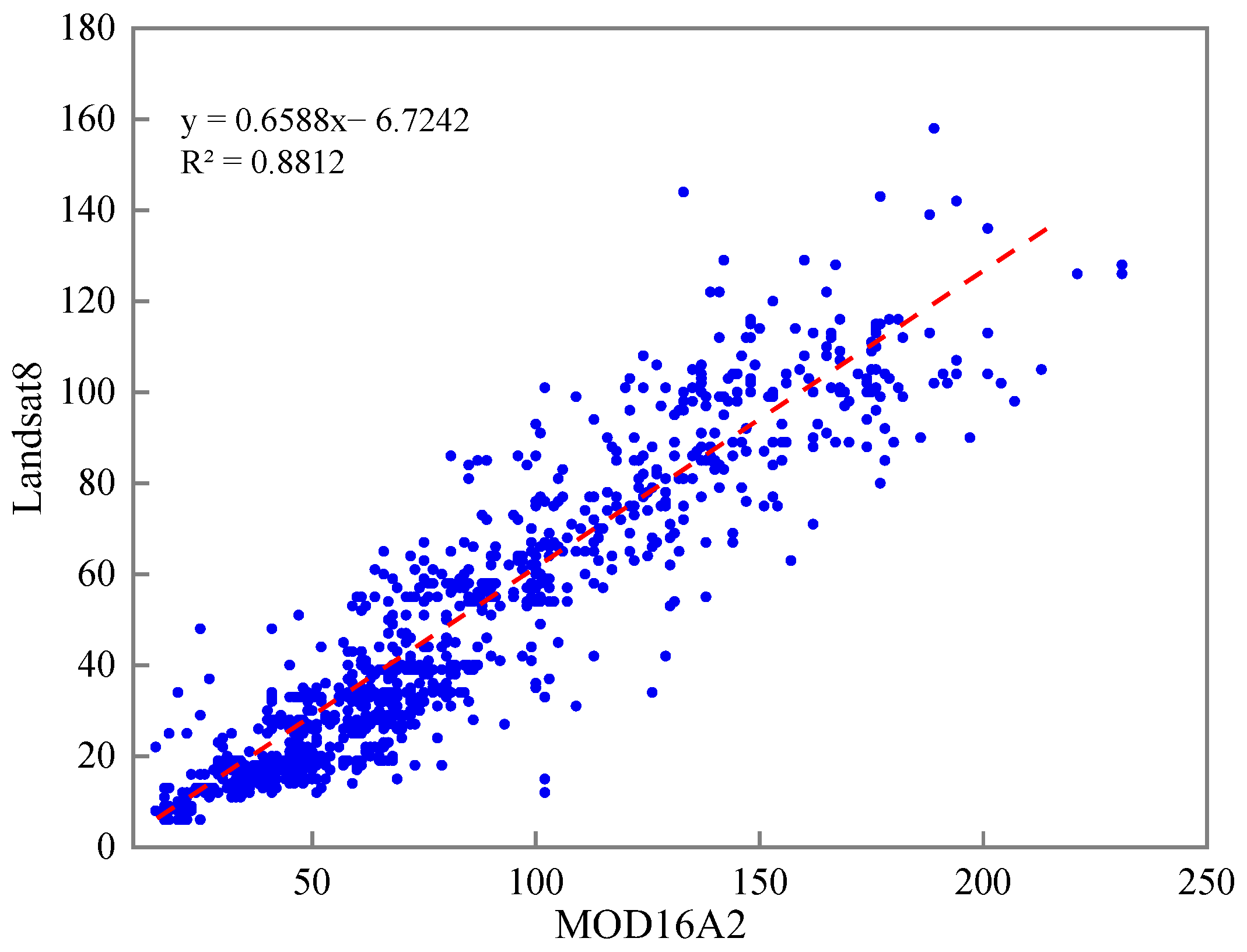
The Evapotranspiration 8-Day composite product (MOD16A2) dataset is a MODIS L4 product obtained from NASA’s website and produced at a spatial resolution of 500 m (https://appeears.earthdatacloud.nasa.gov/, accessed on 18 May 2023) [39]. Provided every eight days, it includes layers such as vegetation attribute evolution, albedo, and land cover. Twenty consecutive years of MOD16A2 images from 2000 to 2020 were selected for this research, and seasonal and interannual time series data were extracted and synthesized. Due to the lack of measured data in the watershed, this work used the comparative analysis of the estimated ET by Landsat8 on top of the SEBAL [40] model to indicate accuracy. Landsat8 data as of 22 August 2020 were obtained from the Geospatial Data Cloud. The results of the accuracy study showed that the R2 of ET estimated by Landsat8 with MOD16A2 data was 0.88, which meets the accuracy requirement (http://www.gscloud.cn/, accessed on 18 May 2023) (Figure 2).
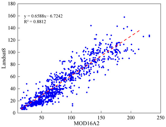
Figure 2.
Data accuracy evaluation.
2.2.2. Land-Cover Data
China’s 30 m annual land-cover product is based on 300,000 Landsat images, combined with existing product automatic stabilization samples and visual interpretation samples. The dataset is based on 5463 independent reference samples, with an overall product accuracy of 79.31% [41]. This dataset reflects the rapid urbanization in China as well as a range of ecological projects, revealing the impact of human activities on the regional land cover under climate change with a spatial separation rate of 30 m. The time series of data selected for this paper were 2000, 2005, 2010, 2015, and 2020, including nine types of land-use data. This research reclassifies these nine types of land-use data into six types: cultivated land, forest land, grassland, water body, construction land, and unused land (http://irsip.whu.edu.cn/resources/CLCD.php, accessed on 18 May 2023).
2.2.3. Terrain Data
The Shuttle Radar Topography Mission (SRTM) data were jointly measured by NASA and the National Imagery and Mapping Agency (NIMA) of the Department of Defense, and the acquired radar image data were processed for more than two years to produce the Digital Terrain Elevation Model (DEM), with a spatial separation rate of 30 m. To study the influence of topographic factors on ET, the data [42,43] on elevation, slope, and slope direction of the Urumqi River Basin were reclassified, according to the topographic features of the watershed (https://srtm.csi.cgiar.org, accessed on 18 May 2023). The elevation levels are described in detail in Table 1.

Table 1.
Terrain data level classification.
2.2.4. Other Data
The vegetation index data were obtained from NASA. The algorithm follows the criteria of low clouds, the low angle of view, and the highest NDVI/EVI values and selects the best value from the 16 days of acquired data as the pixel value of the image, with a resolution of 250 m (https://appeears.earthdatacloud.nasa.gov, accessed on 18 May 2023) [44,45,46].
Meteorological data, including precipitation and temperature data, were obtained from the National Qinghai–Tibet Plateau Scientific Data Center [47,48,49]. China’s 1 km resolution monthly average temperature dataset (1901–2020) was based on the global 0.5° climate dataset released by CRU and the global high-resolution climate dataset released by World Clim (https://data.tpdc.ac.cn/home, accessed on 18 May 2023).
2.3. Methods
2.3.1. Trend Analysis Method
The Theil–Sen median trend analysis and the Mann–Kendall test method can be combined well, and this has thus become an essential method for judging long-term sequence data trends. The formula is as follows [50]:
Here, SET > 0 indicates that the area’s ET has improved over time, while SET < 0 means it has degraded.
The Mann–Kendal calculation formula is as follows:
When using 0.95 as the confidence level, the value of Z is 1.96, meaning Z ≥ 1.96 is a significant increase, 0 < Z < 1.96 is a general increase, Z = 0 is insignificant, 1.96 < Z < 0 is a general decrease, and Z ≤ −1.96 is a significant decrease. Combining the trend analysis method based on the pixel scale, the slope of the spatial trend of change in ET could be simulated, and then the trend of change was divided into five trends as follows: decrease (Z < −1.96); slight decrease (Z ≥ 1.96); stable (Z = −1.96 to 1.96); slight increase (Z = −1.96 to 1.96); and significant increase (Z ≥ 1.96).
2.3.2. ET Dynamic Analysis Method
To study the temporal trend of ET in the study area from 2000 to 2020 in more depth, the spatial distribution map of ET was spatially superimposed on the time series as an axis. The difference method was used to analyze the dynamic change characteristics of ET with the following equation [51]:
where ΔET denotes the ET level, and ET1 and ET2 are the ET levels in different periods. Negative values of ΔET = −2 denote decreased severely (DS); ΔET = −1 denotes decrease slightly (DE); ΔFVC = 0 denotes unchanged (UN); positive values of ΔET = 1 denote a slight increase (SN); and ΔET = 2 denotes a severe increase (SE).
2.3.3. Average ET
The Arcgis Mean Center tool creates a new point element class, where each element in the element class represents a mean center that determines the mean value of the input on an element-by-element basis [52]. The main formula is as follows:
where Xi point is the X axis coordinates, Yi point is the Y axis coordinates, and i = 1, 2… n.
The 20-year average ET and seasonal average ET for the study area were tallied using this method.
2.3.4. Analysis of Land-Use Transfer Matrix
A land-use transfer matrix is used to characterize the transformation relationships between land-use types in different periods in the study area, which can describe the characteristics of changes in land-use structure and the direction of each other’s transfer, and to reflect the trend of transfer of land-use types [53]. This study used overlay analysis and statistical tools to obtain land-use matrices for the years 2000–2005, 2005–2010, 2010–2015, 2015–2020, and 2000–2020. The temporal and spatial changes in land use in the study area over the past 20 years were analyzed. The formula is as follows:
where Sij represents the land-use status, and k and are different land-use types.
2.3.5. Optimal Parameters-Based Geographical Detector Model
The Optimal Parameters-based Geographical Detector model (OPGD) [54] is a tool that can be used to detect and reveal spatial differences between data, in which the difference factor is measured by q. The p-value corresponding to the q-value of each type of quantity X (independent variable) in a geographical detector represents the significance of this factor. The value of q takes the range [0, 1], and the larger the q value, the stronger the explanatory power of the impact factor on the ET, and vice versa, the smaller the value, the weaker it becomes:
where q is the differentiation factor; i is the number of variable categories; j is a specific type; Hj is the number of units; and is variance.
The interaction detection function of OPGD can analyze the interaction between different factors [55]. To ensure the consistency of input data from geographical detectors, the natural breakpoint method in the reclassification tool was used to classify the impact factors into nine categories according to their major criteria. Based on the size of the watershed, a 2 × 2 km grid was created for the reclassified data. Extracting pixel values from centroid points of the grid, and after eliminating invalid values, a total of 6227 grid-point data were obtained. Finally, this dataset was substituted into the geographical detector model for processing.
3. Results
3.1. Characteristics of ET Changes
3.1.1. Interannual and Seasonal Variation of ET
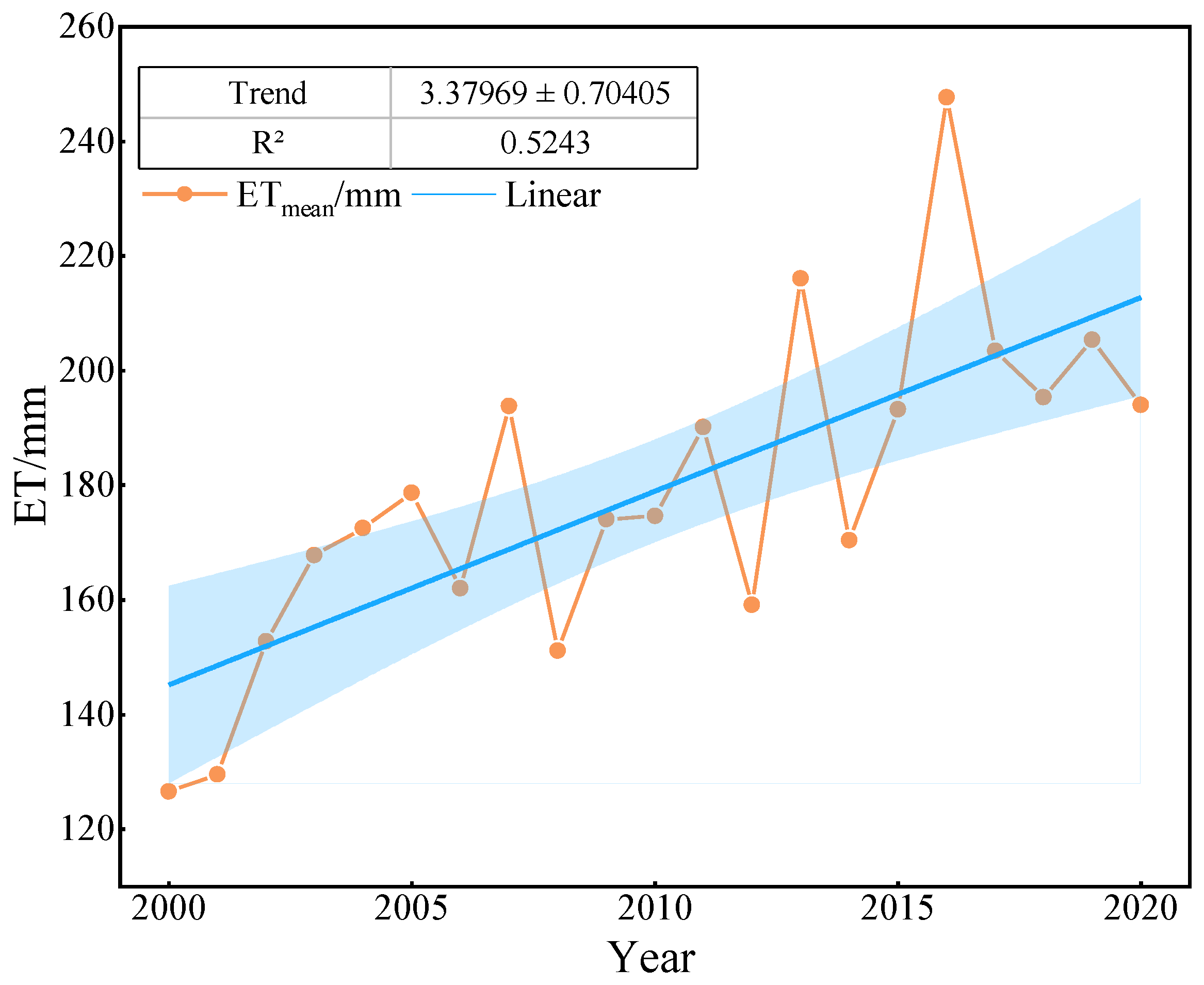
The average ET for the study area from 2000 to 2020 is shown in Figure 3. The overall trend of enhanced evapotranspiration across the basin has fluctuated over the past 20 years. The variation range was between 126.57 mm and 247.66 mm, with the maximum ET reaching 247.66 mm in 2016. In 2000 and 2001, ET was relatively low, at 126.57 mm and 129.55 mm, respectively. Among the variations, the change in ET showed an increasing trend for five consecutive years from 2000 to 2005. After 2005, there began to be significant fluctuations, with higher ET values in 2007, 2013, and 2016 of 193.86 mm, 216.11 mm, and 247.66 mm, respectively. Overall, since 2000, the average ET in the Urumqi River Basin has shown an increasing trend, but it is worth noting that it gradually decreased during 2016–2020.
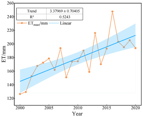
Figure 3.
ET interannual variation.
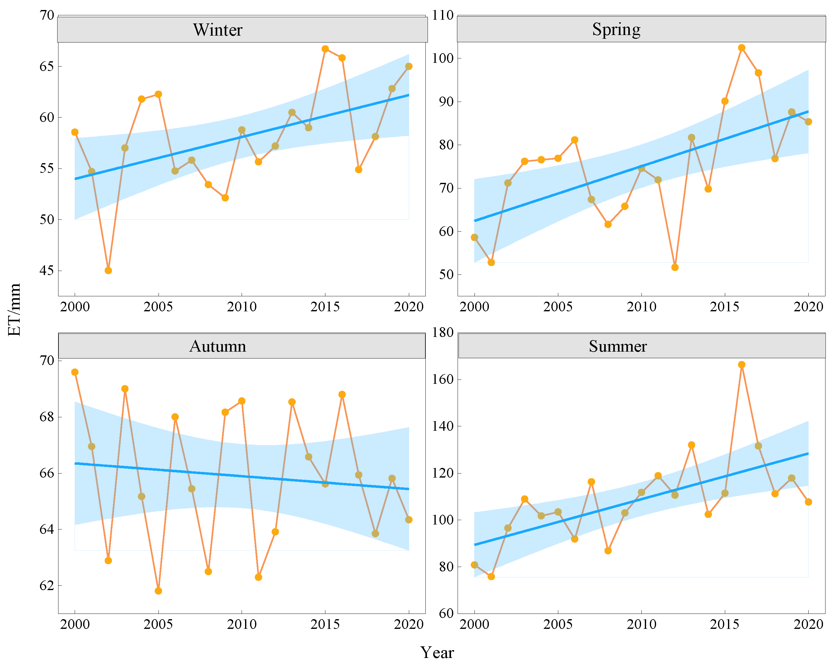
To understand the intra-annual variation characteristics of ET in more detail, the average value method yielded ET values for different seasons, and it was found that there were obvious seasonal differences in ET (Figure 4), with the highest ET in summer (June to August), followed by spring (March to May), autumn (September to November), and winter (December to February), and slightly lower ET in winter than in autumn (Figure 4). In the last 20 years, the highest and most fluctuating ET was observed in summer, with an average value of 95.18 mm; the lowest ET value occurred in 2001 and the highest ET value in 2017. In spring, the average ET value was 45.32 mm, with the lowest occurring in 2012 and the highest occurring in 2016. From 2000 to 2016, ET showed a continuously increasing trend. During this period, extreme weather phenomena frequently occurred in the basin, with high temperatures and less precipitation. ET, therefore, continued to increase, although it has shown a downward trend since 2016. The average values in autumn and winter were 31.96 mm and 11.62 mm, respectively. The lowest value in autumn occurred in 2006, while the highest value occurred in 2016. In the past 20 years, ET in winter and autumn has generally remained stable.
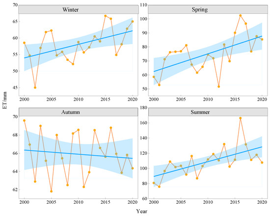
Figure 4.
Seasonal variation in ET in the Urumqi River Basin. Blue zones represent the 95% confidence interval.
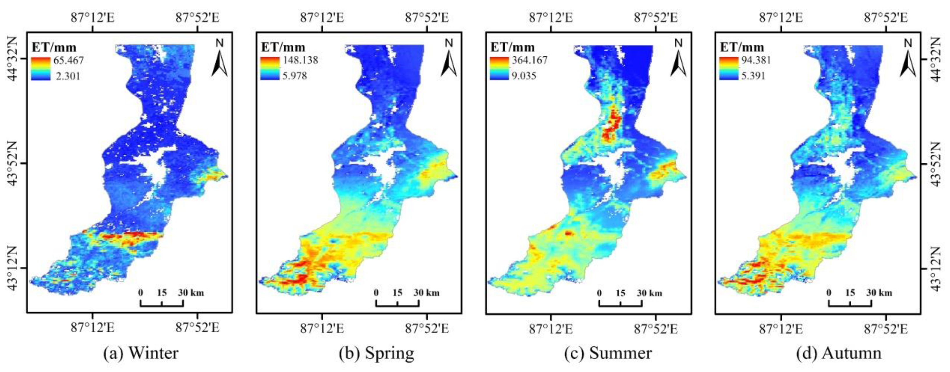
Spatially, ET in the upper reaches of the basin was high throughout the year. Due to the rich vegetation in the upper reaches, vegetation transpiration was significant in the forest area near Urumqi County. In the middle reaches, ET was not high in all seasons but slightly increased in summer, mainly due to the concentrated distribution of cities and more impervious surfaces in this region. ET in the downstream zone was higher in spring and summer and lower in autumn and winter; it was higher in the downstream Midong District and Wujiaqu City section. Since the downstream area is dominated by arable land, artificial irrigation is required during the initial growth stage of crops and other vegetation in spring, and soil evaporation increases ET. In summer, the temperature in the region increases, and vegetation transpiration and soil evaporation are more intense, resulting in increased ET. In autumn, vegetation begins to wither, and precipitation decreases relatively, so downstream ET gradually decreases from this time. The ET value in winter is the lowest, mainly due to the low temperature (Figure 5).
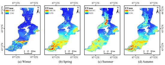
Figure 5.
Seasonal variation of ET in the study area (2000–2020): (a) winter; (b) spring; (c) summer; (d) autumn.
3.1.2. Changes in ET Spatial and Temporal Dynamics
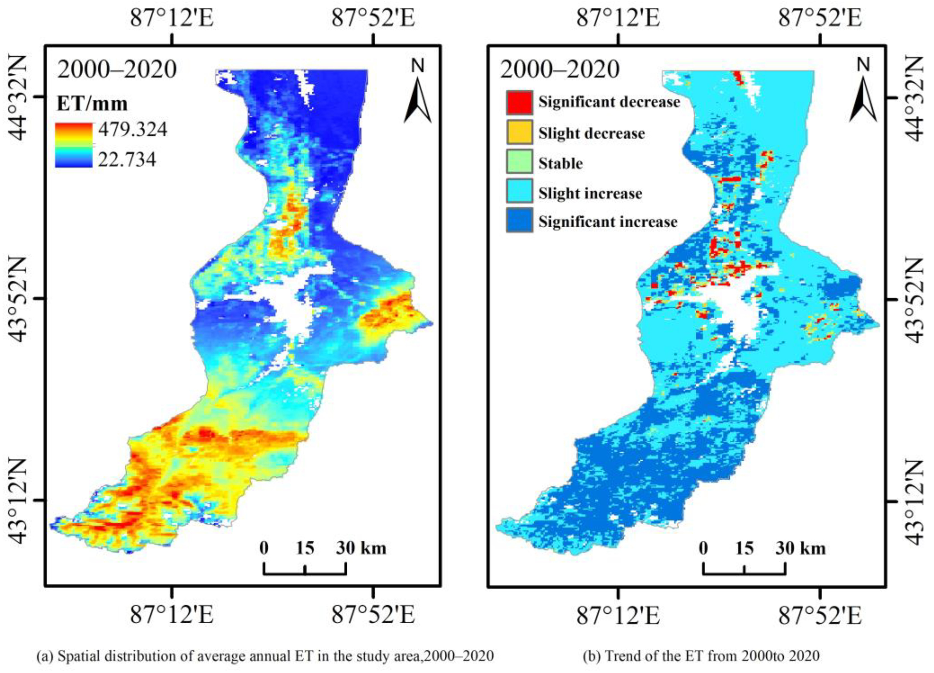
The spatial distribution of the annual average ET for nearly 20 years is shown in Figure 6a. The average value of ET over many years varies from 22.74 mm to 479.33 mm. Figure 6a shows a high upstream (south) value and a low downstream (north) value. The main cause of the difference is that the upstream terrain of the Urumqi River Basin is mountainous, with abundant precipitation and dense vegetation, while the middle reaches of the region are urban, and the lower reaches are dominated by farmland and contain a portion of the Gurbantünggüt Desert. Due to the high solar radiation, long sunshine hours, low precipitation, and insufficient water supply of the underlying desert surface, ET is low in this lower region.
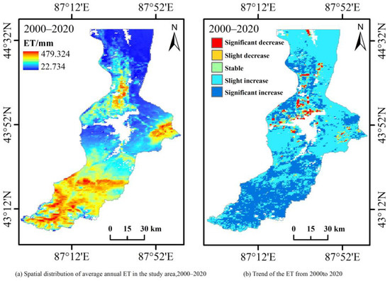
Figure 6.
(a) Spatial distribution of mean multi-year ET. (b) Multi-year average ET trend distribution.
To further examine the spatial trends of ET between 2000 and 2020, the spatial distribution of the interannual linear change trend for the past 20 years was obtained using the linear trend calculation method, by dividing the ET change interval by the natural breakpoint separation method, as shown in Figure 6b. The zones with a decrease or a slight decrease in ET were mainly concentrated in the arable areas around downstream Midong and Wujiaqu, accounting for about 14.62% and 27.27% of the total watershed area, respectively. Regions with basically stable ET were concentrated in Dabancheng, accounting for 8.14%. The slight increase in ET was mainly concentrated in the midstream (Shaibak District and Tianshan District) and downstream (Desert District) areas, accounting for 31.21%, while the significant increase was mainly distributed in the upstream, accounting for 18.76%. Overall, a slight decrease in the lower reaches and a slight increase in the middle reaches dominated the trend results, indicating that the ET pattern within the basin has changed in the last 20 years.
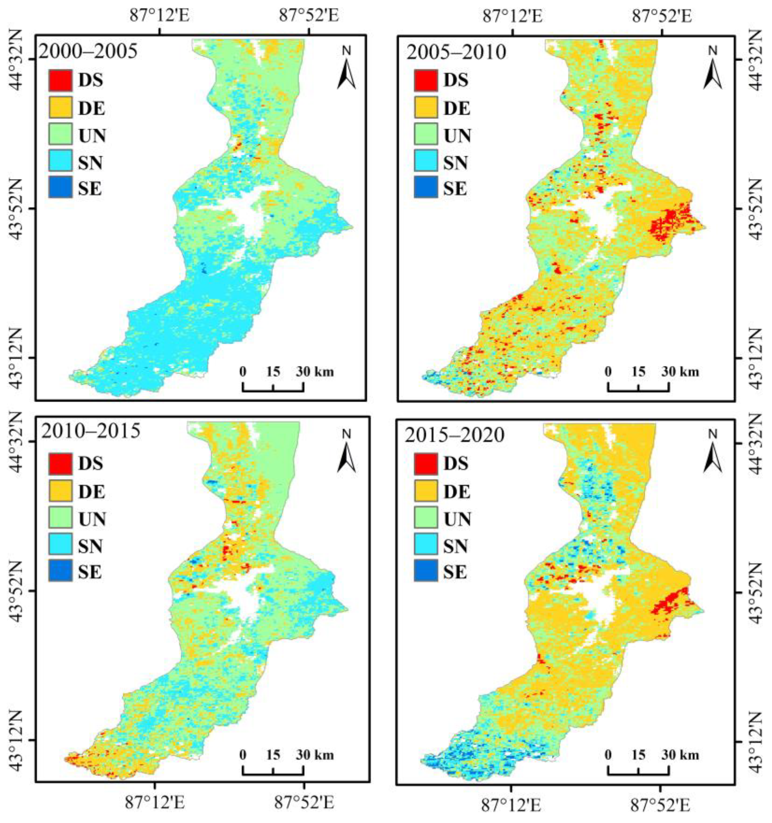
To study the spatial changes in evapotranspiration in the Urumqi River Basin in the last 20 years, the evapotranspiration data in the study area from 2000 to 2020 were superimposed to obtain the spatial distribution pattern of evapotranspiration and its evolutionary characteristics in the Urumqi River Basin, as shown in Figure 7. The spatial variation of evapotranspiration in the basin in the past 20 years is significant. From 2000 to 2005, the evapotranspiration in the Urumqi River Basin tended to increase slightly, and the slight increase (SN) was mainly distributed in the upper reaches, while the evapotranspiration in the middle and lower reaches remained unchanged. ET tended to decrease slightly from 2005 to 2010, and evapotranspiration decreased severely (DS) in the midstream. From 2010 to 2015, ET did not change much in most areas of the study area, with a slight increase in the upstream woodland area, a slight decrease in the downstream farmland area, a small area of apparently decreasing areas, and no change in the other areas. ET tended to decrease slightly (DE) from 2015 to 2020, with the main areas of increase being the urban areas in the midstream and the desert areas in the downstream. Based on the recent ET changes in the study area from 2000 to 2020, it can be assumed that the ET in the upper part of the study area increased overall, decreased severely in a small area in the eastern part of the middle reaches, and decreased slightly or remained unchanged in the lower part of the study area during this period.
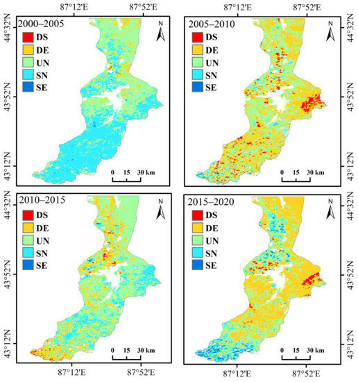
Figure 7.
Dynamic changes in ET.
3.2. Correlation Analysis of ET Influencing Factors
3.2.1. Correlation with Land-Use Factors
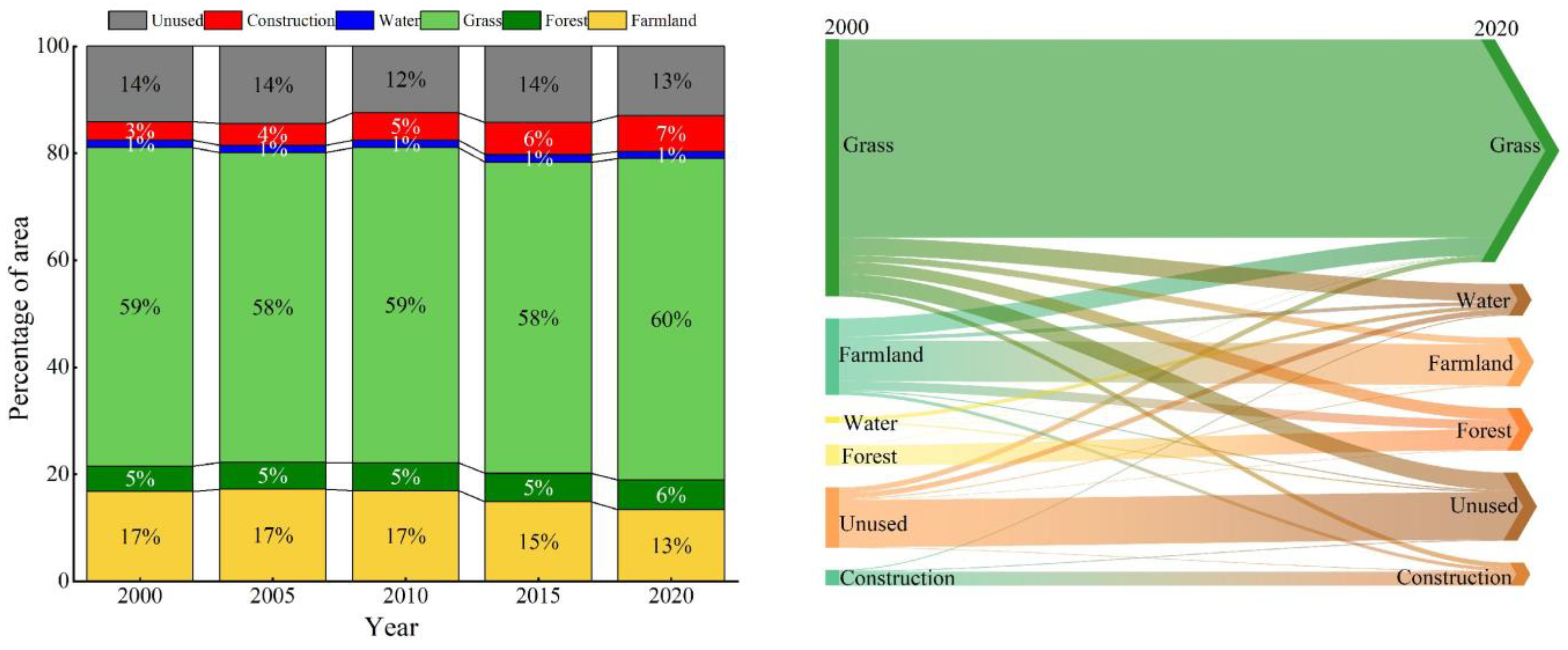
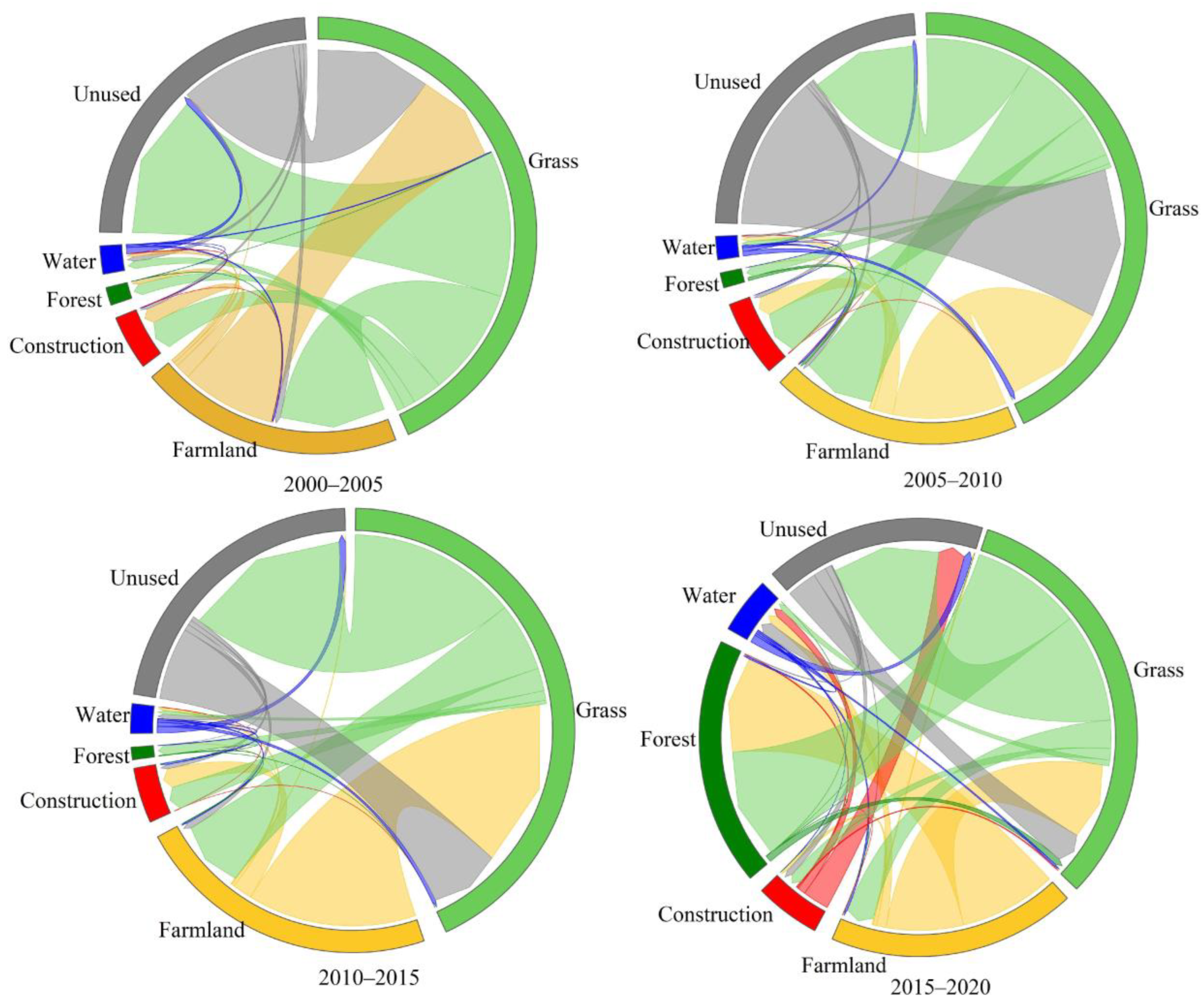
Different types of land use are disturbed by humans to varying degrees, which can have an impact on changes in ET and also be an important reason for ET changes [56,57]. The land-use data for different years in the study area are shown in Figure 8. From 2000 to 2020, the Urumqi River Basin was dominated by grassland, accounting for nearly 60% of the total area, which is a typical arid area watershed feature. In 2000, the various land-use types in the basin were ranked by area as follows: grassland > farmland > unused land > forest land > construction land > water body. In 2020, after 20 years of development, construction land had increased significantly, with the total area exceeding that of forest land. The order of land type area ratio thus changed to grassland > farmland > unused land > construction land > forest land > water body. From the perspective of land-use transfer in the past 20 years, grassland and farmland were the types that had been transferred out the most. Grassland was the most frequently transferred out, to all types of use, while farmland was mainly transferred to grassland and unused land, due on the one hand to the government’s policy of returning farmland to forest and grass but on the other hand due to the drought conditions of a fragile ecological environment leading to some of the arable land being converted to abandoned land. Construction land, forest land, and unused land were mainly transferred in, and the increase in construction land was largely due to urban expansion. The increase in forest land was due to the increase in some grassland thickets and artificial forest land. The increase in unused land may have been due to the centralized utilization of water resources within the watershed and the decrease in water content, which may in turn have led to the conversion of some desert grasslands into unused land. The water body area remained relatively small and relatively balanced, with a slight increase, but was still less than 1% of the watershed area.
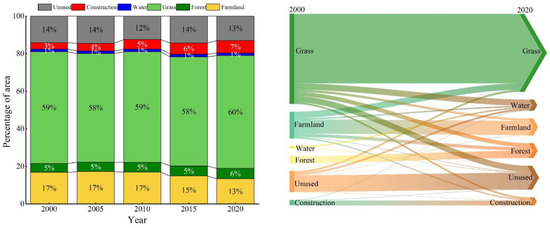
Figure 8.
Land-use area change and transfer matrix.
The changes in land-use types in the Urumqi River Basin from 2000 to 2020 are shown in Figure 9. Figure 9 shows that the area of unused land converted from grassland between 2000 and 2005 was 237.19 km2, while the area of unused land transferred to grassland was 190.08 km2. The main converted land-use types in the Urumqi River Basin between 2005 and 2010 were grassland, farmland, and unused land, with the maximum area of unused land converted to grassland being 311.65 km2. Between 2010 and 2015, a large amount of farmland was converted into grassland, with a transformation area of 375.24 km2. From 2015 to 2020, the area of grassland transformed into forest land was the largest, at 305.57 km2. In 2020, the Urumqi River Basin continued to have grassland as the mainland type. The proportion of water bodies and unused land was relatively stable and slightly decreased, while, among the other land types, forest land and construction land continued to increase, with the largest increase in construction land and the largest decrease in farmland during the study period.
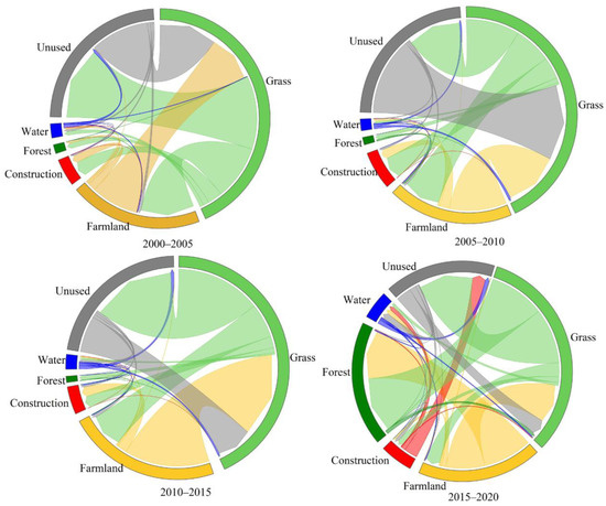
Figure 9.
Land-use transfer chord map for the Urumqi River Basin, 2000–2020.
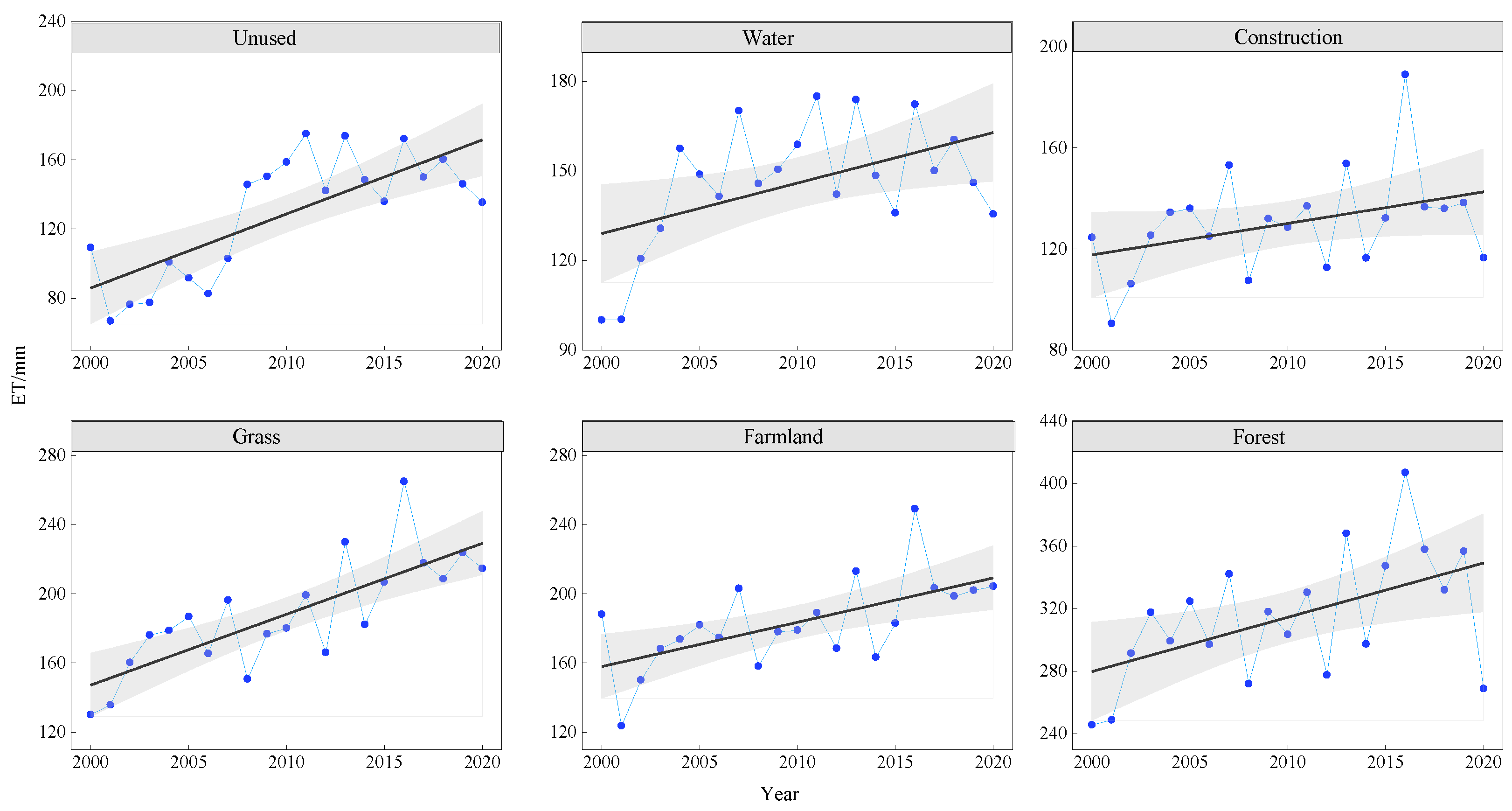
To study the variation in the ET characteristics of different land-cover types, the interannual trends of ET were statistically analyzed for six land-cover types from 2000 to 2020 (Figure 10). The ET of forest land was the highest, followed by grassland and cropland, and the ET of unused land was the lowest. Overall, the average ET was ordered as follows: forest land > grassland > cropland > water body > construction land > unused land. Among these results, the average ET of forest land was the highest, and the overall trend was fluctuating and increasing. The average ET was the highest in 2015, reaching 347.21 mm, while in 2000 the average value was smaller, at 245.66 mm. ET in farmland, grassland, and water bodies also showed a fluctuating trend of increase, but it was relatively slow compared to forest land. The ET of construction land was relatively low and changed steadily and largely came from the urban greening zones. The ET of unused land was the lowest among the six types of land use, mainly due to the low water content, high temperature, and low precipitation of unused land, including bare rocks and deserts. In summary, looking at the past 20 years, ET was relatively small in 2000 and relatively large in 2020.
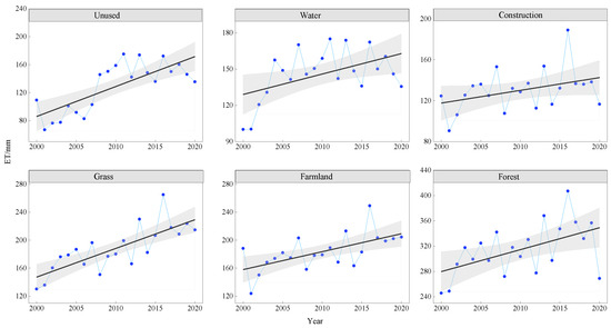
Figure 10.
Interannual variation in ET for different land covers from 2000 to 2020.
3.2.2. Correlation with Topography Factors
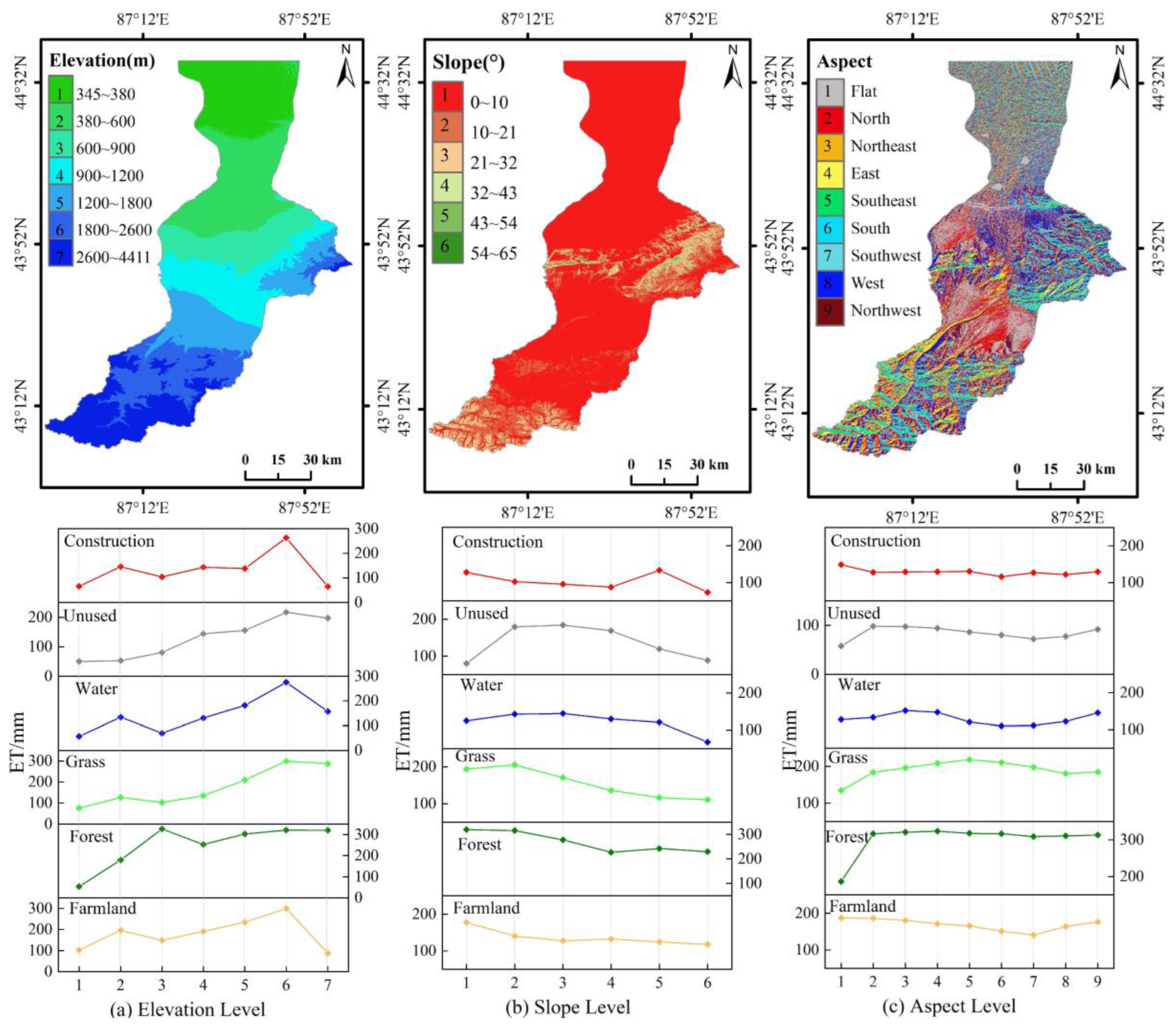
Elevation is a basic terrain feature whose changes alter soil moisture and surface runoff, thereby affecting ET [58,59]. Spatial overlay analysis was conducted on land-cover types and elevation data in the watershed to calculate the average ET for each land-cover type at different elevation levels (Figure 11a). As can be seen from the figure, the impact of elevation on ET in the Urumqi River Basin is relatively consistent, with ET increasing with altitude. Except for unused land and grassland, ET continues to increase with elevation; the other land-use types have significant volatility, but the overall trend is increasing. The peaks of land-use types in the seven elevation categories, except for forest land, occur at 1800–2600 m, while the peaks of forest land occur at 550–900 m.
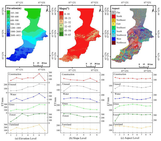
Figure 11.
(a) Effect of elevation on ET. (b) Effect of slope on ET. (c) Effect of aspect on ET.
The average ET was calculated statistically for different slopes of each land-cover type (Figure 11b). The analysis shows that the impact of slope on ET is nonlinear. The ET with a slope of 10–21° has a maximum average of 181.25 mm, followed by 0–10° with an average of 170.34 mm. The ET with a minimum slope of 54–65° has an average ET value of 114 mm. The ET of grassland, forest land, water bodies, and farmland showed a decreasing trend, while the ET of unused land and construction land had fluctuations and integrity. When the slope was greater than 21°, ET decreased significantly with the increase in the slope and tended to stabilize with the increase in the slope. Areas with gentler slopes are convenient for human activities, higher temperatures, less soil moisture, and more land-use types, while higher slopes have progressively fewer topographical constraints on human activities, higher elevations, more direct sunlight, and more precipitation. Thus different land-use types on different slopes show different trends in ET.
From Figure 11c, it can be seen that the northeast aspect and east aspect had the largest ET, and this slope direction was a grassland-concentrated distribution area with an average ET of 179.29 mm, followed by the north slope; the plane had the smallest ET. The ET of different land-use types in different aspect directions also differed. The ET of the northwest aspect of cultivated land gradually decreased, with the average ranging from 150 mm to 200 mm, while the ET of forest land gradually increased from the plane to the north aspect, mainly due to the north aspect of the Urumqi River Basin being a concentrated forest area. The ET of other aspect directions showed little change, all being close to 300 mm. Grassland had a fluctuating nature, and ET from water bodies, unused land, and construction land did not vary much with slope direction.
3.2.3. Relative Contribution of Influences to ET
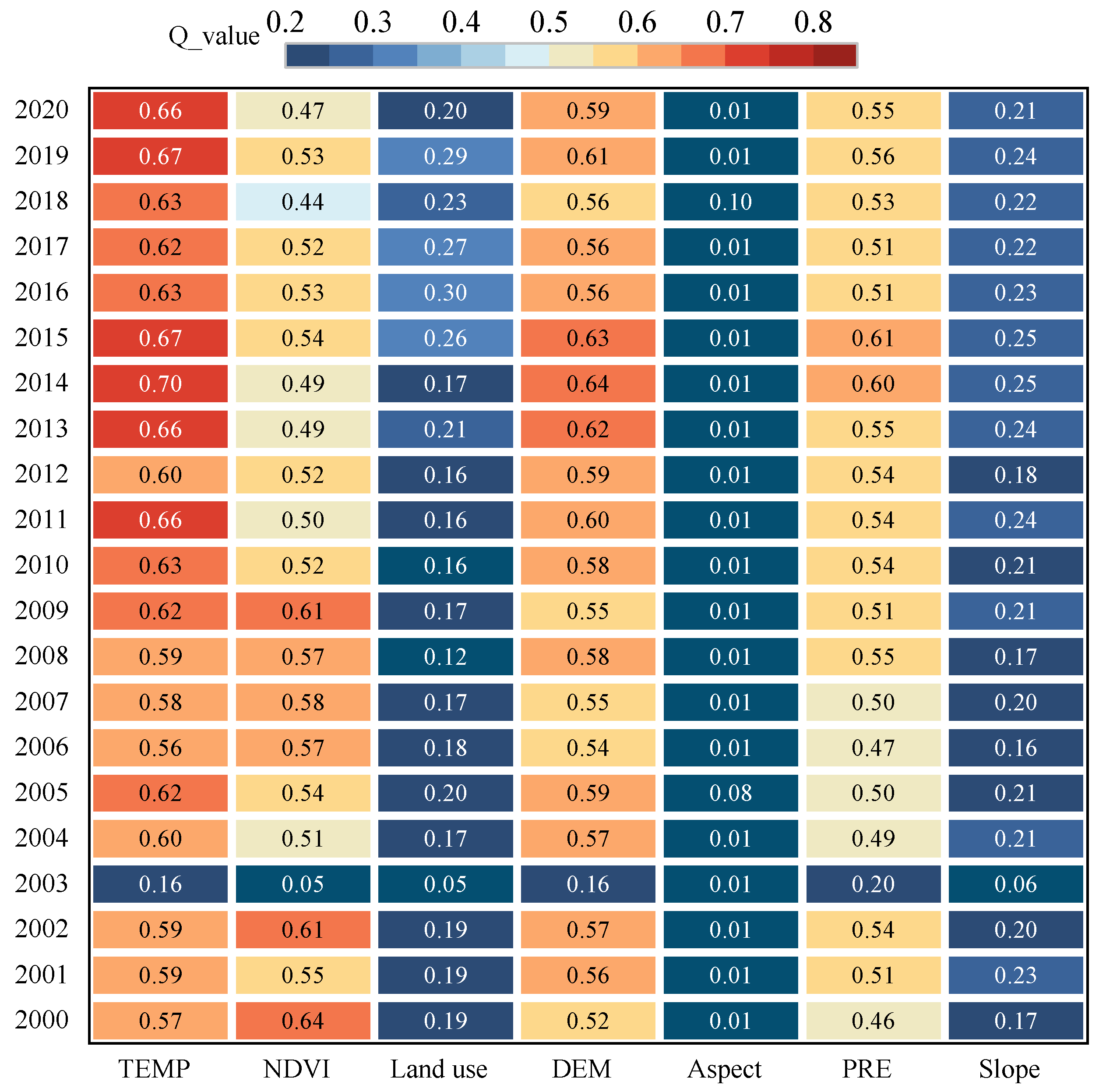
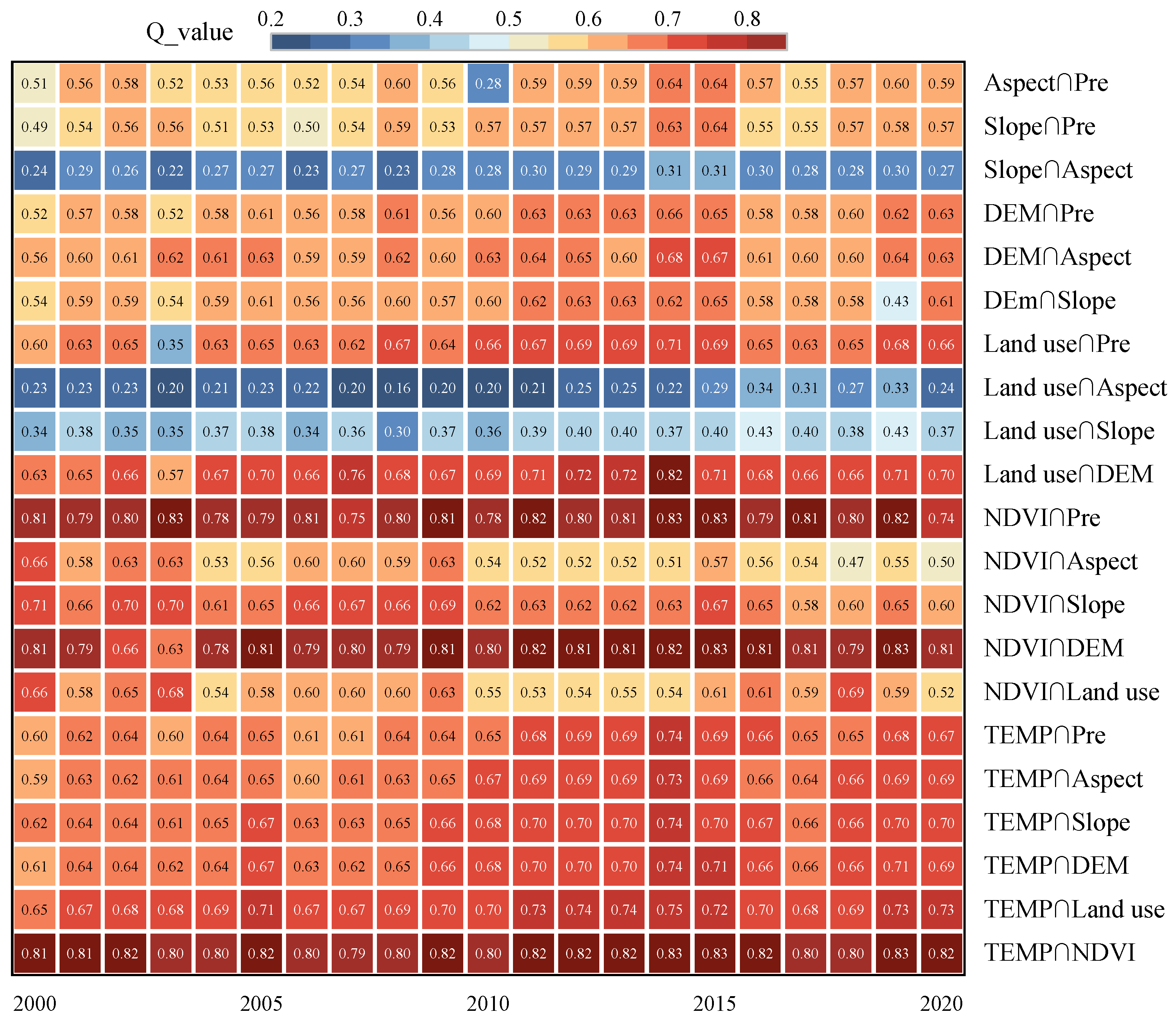
To understand the contribution of different influencing factors to evapotranspiration in more detail, this paper uses OPGD to analyze factor detection and interaction detection separately, as shown in Figure 12 and Figure 13. The Q values of the impact factors are in descending order: temperature (0.599), DEM (0.558), NDVI (0.514), precipitation (0.512), slope (0.205), land use (0.193), and aspect (0.018). Analysis of the impact of the factor detector on ET shows that temperature, DEM, NDVI, and precipitation were the leading factors of ET in the Urumqi River Basin; it is worth noting that the factor detector Q values of land use were all less than 0.5, which has low explanatory power for ET, but reached a double effect under the interaction, so land use is also a factor that cannot be ignored. From the Q values of various factors in different years, it can be seen that, in 2014, the explanatory power of temperature was the strongest, and in 2000, the explanatory power of NDVI was the strongest, with the Q value of these years approaching 0.7.
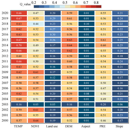
Figure 12.
Effect of factor detector on ET.
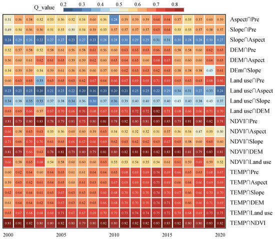
Figure 13.
Factor interaction detection results.
The results show that the influence of interacting factors on ET in this region is greater than that of individual factors. The interaction of factors presented nonlinear or synergistic enhancement without independent relationships, and the interaction results of any two factors showed a nonlinear enhancement characteristic, indicating that the change in ET was affected by multiple factors in coordination. The interacting factor impact values of each representative year were ranked according to their Q values, and those that played a dominant role in the last 20 years were found to be as follows: temperature ∩ NDVI, NDVI ∩ DEM, NDVI ∩ precipitation, and land use ∩ DEM. These results indicate that the interactions of vegetation index with temperature, elevation, precipitation, and elevation with land use had the greatest influence on ET in the study period.
The Urumqi River Basin is a typical mountain–basin structure in the arid zone, with upstream mountainous areas, midstream urban plains, and downstream cultivated and desert areas suitable for population livability and agricultural development. The upstream region is a forest area, and the downstream region is dominated by corn crops, with high vegetation moisture content. The combination of these factors had a significant impact on ET.
4. Discussion
4.1. Analysis of the Causes of Spatiotemporal Variation in ET Characteristics
The results presented in this paper show that in the interannual variation of the Urumqi River Basin during the period 2000–2020, the average evapotranspiration for many years was 180 mm, with a range of 126.57–247.66 mm, with an overall slow increasing trend, and the average annual evapotranspiration in the basin was less than 250 mm. Yang et al. [60], in their study of ET in the global arid zone, found that the annual average ET in arid and semi-arid regions of the globe was less than 300 m, and the multi-year ET showed an increasing trend, compared to which the multi-year average evapotranspiration trend in the Urumqi River Basin was consistent. However, the interannual evapotranspiration in the Urumqi River Basin is less than the global average for arid and semi-arid regions, and our study area evapotranspiration grows more rapidly. Compared with the results of Liu et al.’s [61] study on ET in the arid region of northwest China, the ET in the arid region of northwest China is generally smaller, with the ET being less than 200 mm, and the multi-year average ET in the Urumqi River Basin is larger than that in the arid region of northwest China. Moreover, our study shows that there have been several special years of ET in the basin in the past 20 years. The lower ET in 2000, 2001, and 2008 was mainly due to the lower precipitation in the study area in those years (average annual precipitation of 130 mm). From 2015 to 2016, ET fluctuated significantly, mainly due to the historically rare occurrence of large-scale, long-term, and high-strength, high-temperature weather in Xinjiang starting from July 2015 [62], with the warmest year and increased temperatures coupled with the frequent occurrence of extreme weather and climate events, such as snowstorms in Xinjiang from 2015 to 2016 [63,64]. In the spatial distribution, the mean ET values in the Urumqi River Basin showed a high–high–low distribution in spatial order from south to north, a feature that is consistent with the findings of Li et al. [65] on the spatial distribution of ET in the arid zone of northwest China. However, our results differed from those of Deng et al. [66] in that they showed lower ET in the middle of the study area, compared to our results showing higher ET in the middle of the watershed. This is mainly since the middle of the watershed is a built-up area with high temperatures, and the intensification of the urban greening policy has a positive effect on the ability to promote the transpiration of vegetation, thus resulting in higher ET in the upper and middle reaches of the watershed.
4.2. Analysis of Impact Factors
Geoprobes can test both the spatial dissimilarity of a single variable and the coupling of the spatial distribution of two variables to detect the possible causal relationship between the two variables, and the use of such probes to explore these driving factors has an obvious advantage in terms of spatially, numerically, and quantitatively investigating the impacts of each factor on the evolution of ET in the study area. The strength of the explanatory power of different influencing factors on ET varied, and the order of the magnitude of the factors’ Q values was temperature (0.599) > DEM (0.588) > NDVI (0.514) > precipitation (0.512) > slope (0.205) > land use (0.193) > aspect (0.018). However, the spatial heterogeneity of ET in the Urumqi River Basin was found to not be controlled by a single factor. Rather, the influence of most factors was enhanced under interaction with other factors, that is, the impact of the interaction of two factors on ET was far greater than the impact of any single factor. According to the magnitude of the Q value, the interacting factors with dominant effects in the past 20 years were temperature ∩ NDVI, NDVI ∩ DEM, NDVI ∩ precipitation, and land use ∩ DEM, indicating that the interaction of the vegetation index with temperature, elevation, precipitation, and land use with elevation had high explanatory power over ET. The Q value of land use was less than 0.5, indicating low explanatory power, but this doubled when its interaction with other factors was considered, i.e., its influence on ET was greatly enhanced. Many studies [67,68] have shown that temperature and NDVI are the main factors affecting ET, but our study shows that, in addition to temperature and NDVI, DEM and land use also have a strong influence on ET. This influence can be attributed to the typical mountain–basin structure of the arid zone in our study area, with its upstream mountainous area, midstream oasis plain area, and downstream desert area from south to north, which is a typical ‘mountain–oasis–desert’ topography. Due to the special geographical location of the Urumqi River Basin, a detailed analysis of ET at different altitudes was conducted, revealing results that were different to those reported by Lin et al. [25] in their study on the Liao He Plain. The impact of altitude on ET over the Liao He Plain is that, as altitude increases, ET decreases significantly. However, our results are opposite to this, with ET significantly increasing as altitude increases.
4.3. Shortcomings and Research Significance
Water resources are the bottleneck of sustainable development in arid zone watersheds, and the study of ET changes in arid zones is of great significance to the management of water resources and their consumption, as well as the protection of the ecological environmental in such regions. However, there were some limitations to our study; for example, in this study, natural and anthropogenic factors were combined to analyze the characteristics and factors influencing ET changes in the Urumqi River Basin over 20 years and to evaluate the spatial distribution pattern and trends of change in ET. In this study, MOD16A2, a remote sensing product with high temporal resolution, was used to quantitatively analyze the spatial distribution of ET in the Urumqi River Basin. Whilst relatively less costly, its data accuracy is not as good as that of traditional ET measurements (i.e., ET meters); plus, such data cannot show the subtle changes in ET in more detail than the image metric scale. In addition, although this study attempted to select influencing factors in terms of natural (temperature, precipitation, topography, vegetation cover) and anthropogenic (land-use type) considerations, there are more factors than that influencing ET that need to be considered in future work to better inform improvements in the scientific management of water resources for agriculture and ecosystem use in the Urumqi River Basin.
Despite these limitations, we effectively quantified the spatiotemporal variation of evapotranspiration and its driving factors in the Urumqi River Basin. The results of this study will be helpful in understanding the climate and ecosystems of arid areas and how to adapt to and mitigate the effects of drought and can also help us predict the occurrence and extent of drought and develop responses. This work aims to provide a basis for the sustainable development of the hydrological ecosystem and scientific management of water resources in the Urumqi River Basin.
5. Conclusions
Based on MODIS data from 2000 to 2020, this paper used long-time series evapotranspiration data from the Urumqi River Basin to calculate and analyze the spatiotemporal distribution characteristics, changing trends, and differences in ET among different land-use types and discussed the impact of ET’s driving factors in the basin. The main conclusions reached at the end are as follows:
- (1)
- The average basin evapotranspiration has been increasing for 20 years, and the annual basin evapotranspiration variation ranges from 126.57 to 247.66 mm. The seasonal scale of ET is mainly summer > spring > autumn > winter. At the spatial scale, the surface ET in the Urumqi River Basin is generally high upstream (south) and low downstream (north). The multi-year ET average in the basin is 22.74–479.33 mm, with significant spatial distribution differences. The severe and slight decrease in average ET is mainly concentrated in the downstream Midong area and the cultivated land area around Wujiaqu. The ET in the upstream presents a significant increasing trend, while other areas remain unchanged or record a slight increase.
- (2)
- From the analysis of land-use changes, it can be seen that grassland and cultivated land account for a relatively large proportion of the area of the Urumqi River Basin. Taking 2020 as an example, the average proportions of various types of land use are 58.25% and 15.67%, respectively. Among the six land-cover types, the type with the highest ET mean value was forest land, followed by grassland, cropland, and water bodies. The effect of elevation on ET was more consistent, with a significant increase in ET with increasing altitude.
- (3)
- Analysis of the factors influencing the spatial and temporal variation of ET revealed that these varied from year to year. Temperature, DEM, NDVI, and precipitation have been having a crucial influence on ET in the Urumqi River Basin. However, the influence of two-factor combinations on the spatial distribution of ET was found to be stronger than any individual factors, especially the interactions among vegetation, temperature, precipitation, and land use.
Author Contributions
Conceptualization, H.Y.; methodology, K.A.; software, K.A.; validation, K.A.; formal analysis, K.A.; investigation, H.Y.; resources, H.Y.; data curation, K.A.; writing—original draft preparation, K.A.; writing—review and editing, H.Y., K.A.; visualization, A.M.; supervision, H.Y. All authors have read and agreed to the published version of the manuscript.
Funding
This research was funded by the National Natural Science Foundation of China (42061007, 42261058).
Data Availability Statement
Not applicable.
Acknowledgments
The authors would like to thank Han Yang and others for their help in this study.
Conflicts of Interest
The authors declare no conflict of interest.
References
- Zhan, M.; Wang, G.; Hagan, D.F.T.; Waheed, U.; Giri, K.; Lu, J.; Li, S. Impacts of Vegetation Changes on Land Evapotranspiration in China During 1982–2015. Front. Environ. Sci. 2022, 10, 17. [Google Scholar] [CrossRef]
- Deng, O.; Li, Y.Q.; Li, R.S.; Yang, G.B. Estimation of Forest Ecosystem Climate Regulation Service Based on Actual Evapotranspiration of New Urban Areas in Guanshanhu District, Guiyang, Guizhou Province, China. Sustainability 2022, 14, 10022. [Google Scholar] [CrossRef]
- Hao, X.M.; Fan, X.; Zhao, Z.Y.; Zhang, J.J. Spatiotemporal Patterns of Evapotranspiration in Central Asia from 2000 to 2020. Remote Sens. 2023, 15, 1150. [Google Scholar] [CrossRef]
- Zhu, X.Q.; Jin, X.M.; Zhang, X.C.; Zhang, J. Regional analysis of evapotranspiration changes in an arid river basin using satellite observations. Arid. Land Res. Manag. 2021, 35, 251–275. [Google Scholar] [CrossRef]
- Yassen, A.N.; Nam, W.H.; Hong, E.M. Impact of climate change on reference evapotranspiration in Egypt. Catena 2020, 194, 11. [Google Scholar] [CrossRef]
- Pourmansouri, F.; Rahimzadegan, M. Evaluation of vegetation and evapotranspiration changes in Iran using satellite data and ground measurements. J. Appl. Remote Sens. 2020, 14, 21. [Google Scholar] [CrossRef]
- Hou, P.S.; Fadzil, L.M.; Manickam, S.; Al-Shareeda, M.A. Vector Autoregression Model-Based Forecasting of Reference Evapotranspiration in Malaysia. Sustainability 2023, 15, 3675. [Google Scholar] [CrossRef]
- Liu, Z.H.; Jing, D.; Han, Y.; Yu, J.X.; Lu, T.G.; Zhangzhong, L. Spatiotemporal Distribution Characteristics and Influencing Factors Analysis of Reference Evapotranspiration in Beijing-Tianjin-Hebei Region from 1990 to 2019 under Climate Change. Sustainability 2022, 14, 6277. [Google Scholar] [CrossRef]
- Hu, X.H.; Chen, M.T.; Liu, D.; Li, D.; Jin, L.; Liu, S.H.; Cui, Y.L.; Dong, B.; Khan, S.; Luo, Y.F. Reference evapotranspiration change in Heilongjiang Province, China from 1951 to 2018: The role of climate change and rice area expansion. Agric. Water Manag. 2021, 253, 14. [Google Scholar] [CrossRef]
- Zhao, F.B.; Ma, S.; Wu, Y.P.; Qiu, L.J.; Wang, W.K.; Lian, Y.Q.; Chen, J.; Sivakumar, B. The role of climate change and vegetation greening on evapotranspiration variation in the Yellow River Basin, China. Agric. For. Meteorol. 2022, 316, 14. [Google Scholar] [CrossRef]
- Keszeliova, A.; Vyleta, R.; Danacova, M.; Hlavcova, K.; Sleziak, P.; Gribovszki, Z.; Szolgay, J. Detection of Changes in Evapotranspiration on a Catchment Scale Under Changing Climate Conditions in Selected River Basins of Slovakia. Slovak J. Civ. Eng. 2022, 30, 55–63. [Google Scholar] [CrossRef]
- Bai, P.; Liu, X.M.; Zhang, Y.Q.; Liu, C.M. Assessing the Impacts of Vegetation Greenness Change on Evapotranspiration and Water Yield in China. Water Resour. Res. 2020, 56, 20. [Google Scholar] [CrossRef]
- Chang, Y.P.; Ding, Y.J.; Zhao, Q.D.; Qin, J.; Zhang, S.Q. Elevation-dependent changes in the trend of reference evapotranspiration in the Tibetan Plateau during 1960–2017. Int. J. Climatol. 2023, 43, 2077–2095. [Google Scholar] [CrossRef]
- Gan, G.J.; Wu, J.L.; Hori, M.; Fan, X.W.; Liu, Y.W. Attribution of decadal runoff changes by considering remotely sensed snow/ice melt and actual evapotranspiration in two contrasting watersheds in the Tienshan Mountains. J. Hydrol. 2022, 610, 12. [Google Scholar] [CrossRef]
- Jin, X.M.; Guo, R.H.; Xia, W. Distribution of Actual Evapotranspiration over Qaidam Basin, an Arid Area in China. Remote Sens. 2013, 5, 6976–6996. [Google Scholar] [CrossRef]
- Moiwo, J.P.; Tao, F.L. Contributions of precipitation, irrigation and soil water to evapotranspiration in (semi)-arid regions. Int. J. Climatol. 2015, 35, 1079–1089. [Google Scholar] [CrossRef]
- Wang, Y.; Liu, Y.B.; Jin, J.X.; Fan, X.W. Intra-Annual Variability of Evapotranspiration in Response to Climate and Vegetation Change across the Poyang Lake Basin, China. Remote Sens. 2022, 14, 885. [Google Scholar] [CrossRef]
- Yang, L.S.; Feng, Q.; Zhu, M.; Wang, L.M.; Alizadeh, M.R.; Adamowski, J.F.; Wen, X.H.; Yin, Z.L. Variation in actual evapotranspiration and its ties to climate change and vegetation dynamics in northwest China. J. Hydrol. 2022, 607, 13. [Google Scholar] [CrossRef]
- Zheng, Q.Z.; Hao, L.; Huang, X.L.; Sun, L.; Sun, G. Effects of Urbanization on Watershed Evapotranspiration and Its Components in Southern China. Water 2020, 12, 645. [Google Scholar] [CrossRef]
- Wang, Q.L.; Cheng, L.; Zhang, L.; Liu, P.; Qin, S.J.; Liu, L.; Jing, Z.X. Quantifying the impacts of land-cover changes on global evapotranspiration based on the continuous remote sensing observations during 1982-2016. J. Hydrol. 2021, 598, 14. [Google Scholar] [CrossRef]
- Wu, G.A.; Lu, X.C.; Zhao, W.; Cao, R.C.; Xie, W.Q.; Wang, L.Y.; Wang, Q.H.; Song, J.X.; Gao, S.B.; Li, S.G.; et al. The increasing contribution of greening to the terrestrial evapotranspiration in China. Ecol. Model. 2023, 477, 9. [Google Scholar] [CrossRef]
- Guo, Q.; Liang, J.N.; Cao, X.J.; Zhang, Z.D.; Zhang, L. Spatiotemporal Evolution of Evapotranspiration in China after 1998. Water 2020, 12, 3250. [Google Scholar] [CrossRef]
- Chen, D.T.; Liu, W.J.; Huang, F.R.; Li, Q.; Uchenna-Ochege, F.; Li, L.H. Spatial-temporal characteristics and influencing factors of relative humidity in arid region of Northwest China during 1966–2017. J. Arid. Land 2020, 12, 397–412. [Google Scholar] [CrossRef]
- Du, Y.; Zhao, J.; Huang, Q. Quantitative driving analysis of climate on potential evapotranspiration in Loess Plateau incorporating synergistic effects. Ecol. Indic. 2022, 141, 13. [Google Scholar] [CrossRef]
- Lin, N.; Jiang, R.Z.; Liu, Q.; Yang, H.; Liu, H.L.; Yang, Q. Quantifying the Spatiotemporal Variation of Evapotranspiration of Different Land Cover Types and the Contribution of Its Associated Factors in the Xiliao River Plain. Remote Sens. 2022, 14, 252. [Google Scholar] [CrossRef]
- Gu, J.H.; Xue, H.Z.; Dong, G.T.; Zhou, L.J.; Li, J.R.; Dang, S.Z.; Li, S.Z. Effects of NDVI/land-use on spatiotemporal changes of evapotranspiration in the Yellow River Basin. Arid. Land Geogr. 2021, 44, 158–167. [Google Scholar] [CrossRef]
- Ma, Y.L.; Niu, Z.R.; Zhang, R.; Sun, D.Y.; Chen, J.N.; Bai, Z.H. Temporal and Spatial Evolution and Driving Factors of Potential Evaportranspiration in Shule River Basin. Res. Soiland Water Conserv. 2022, 5, 350–357. [Google Scholar] [CrossRef]
- Ribolzi, O.; Lacombe, G.; Pierret, A.; Robain, H.; Sounyafong, P.; de Rouw, A.; Soulileuth, B.; Mouche, E.; Huon, S.; Silvera, N.; et al. Interacting land use and soil surface dynamics control groundwater outflow in a montane catchment of the lower Mekong basin. Agric. Ecosyst. Environ. 2018, 268, 90–102. [Google Scholar] [CrossRef]
- Bai, H.B.; Ming, Z.T.; Zhong, Y.L.; Zhong, M.; Kong, D.D.; Ji, B. Evaluation of evapotranspiration for exorheic basins in China using an improved estimate of terrestrial water storage change. J. Hydrol. 2022, 610, 16. [Google Scholar] [CrossRef]
- Huo, W.; Zhi, X.F.; Hu, S.Q.; Cai, W.Y.; Yang, F.; Zhou, C.L.; MamtiMin, A.; He, Q.; Pan, H.L.; Song, M.Q.; et al. Refined assessment of potential evapotranspiration in the tarim basin. Front. Earth Sci. 2022, 10, 13. [Google Scholar] [CrossRef]
- Wang, Y.X.; Ao, Y.H.; Li, Z.G. Evapotranspiration Characteristics of Different Oases and Effects of Human Activities on Evapotranspiration in Heihe River Basin. Remote Sens. 2022, 14, 6283. [Google Scholar] [CrossRef]
- Wang, K.X.; Zhang, Y.S.; Ma, N.; Guo, Y.H.; Qiang, Y.H. Cryosphere evapotranspiration in the Tibetan Plateau: A review. Sci. Cold Arid Reg. 2020, 12, 355–370. [Google Scholar] [CrossRef]
- Zhang, H.; Wang, L. Analysis of the variation in potential evapotranspiration and surface wet conditions in the Hancang River Basin, China. Sci. Rep. 2021, 11, 10. [Google Scholar] [CrossRef] [PubMed]
- Huai, B.J.; Wang, Y.T.; Li, Z.Q.; Sun, W.J.; Wang, X.Y. Glacier changes and its effect on water resources in Urumqi River Basin, Tianshan Mountains, China, from 1964 to 2014. Arab. J. Geosci. 2018, 11, 9. [Google Scholar] [CrossRef]
- Gao, C.H. Sedimentary facies changes and climatic-tectonic controls in a foreland basin, the Urumqi River, Tian Shan, Northwest China. Sediment. Geol. 2004, 169, 29–46. [Google Scholar] [CrossRef]
- Mamattursun, A.; Yang, H.; Ablikim, K.; Obulhasan, N. Spatiotemporal Evolution and Driving Forces of Vegetation Cover in the Urumqi River Basin. Int. J. Environ. Res. Public Health 2022, 19, 15323. [Google Scholar] [CrossRef]
- Shan, N.; Shi, Z.; Yang, X.; Gao, J.; Cai, D. Spatiotemporal trends of reference evapotranspiration and its driving factors in the Beijing-Tianjin Sand Source Control Project Region, China. Agric. For. Meteorol. 2015, 200, 322–333. [Google Scholar] [CrossRef]
- Yang, Q.; Wang, J.; Yang, D.; Yan, D.; Dong, Y.; Yang, Z.; Yang, M.; Zhang, P.; Hu, P. Spatial-temporal variations of reference evapotranspiration and its driving factors in cold regions, northeast China. Environ. Sci. Pollut. Res. 2022, 29, 36951–36966. [Google Scholar] [CrossRef]
- Che, X.H.; Zhang, H.K.; Sun, Q.; Ouyang, Z.T.; Liu, J.P. MODIS Evapotranspiration Downscaling Using a Deep Neural Network Trained Using Landsat 8 Reflectance and Temperature Data. Remote Sens. 2022, 14, 5876. [Google Scholar] [CrossRef]
- Chang, Y.P.; Ding, Y.J.; Zhao, Q.D.; Zhang, S.Q. Remote estimation of terrestrial evapotranspiration by Landsat 5 TM and the SEBAL model in cold and high-altitude regions: A case study of the upper reach of the Shule River Basin, China. Hydrol. Process. 2017, 31, 514–524. [Google Scholar] [CrossRef]
- Yang, J.; Huang, X. The 30 m annual land cover dataset and its dynamics in China from 1990 to 2019. Earth Syst. Sci. Data 2021, 13, 3907–3925. [Google Scholar] [CrossRef]
- Shen, Y.; Shaffer, S.J.; Jordan, R.L. Shuttle Radar Topography Mission (SRTM) flight system design and operations overview. In Proceedings of the Conference on Microwave Remote Sensing of the Atmosphere and Environment II, Sendai, Japan, 9–12 October 2000; pp. 167–178. [Google Scholar]
- van Zyl, J.J. The Shuttle Radar Topography Mission (SRTM): A breakthrough in remote sensing of topography. Acta Astronaut. 2001, 48, 559–565. [Google Scholar] [CrossRef]
- Amiri, M.; Jafari, R.; Tarkesh, M.; Modarres, R. Spatiotemporal variability of soil moisture in arid vegetation communities using MODIS vegetation and dryness indices. Arid Land Res. Manag. 2020, 34, 1–25. [Google Scholar] [CrossRef]
- Fan, D.; Chen, X.T.; Li, Y.L.; Du, K.; Liu, S.F.; Dang, S.Z.; Guo, P.; Dong, G.T. Spatio-temporal analysis of vegetation variation in the Jinghe River Basin. In Proceedings of the 4th International Conference on Sustainable Energy and Environmental Engineering (ICSEEE), Shenzhen, China, 20–21 December 2015; pp. 1058–1061. [Google Scholar]
- Lamchin, M.; Park, T.; Lee, J.Y.; Lee, W.K. Monitoring of Vegetation Dynamics in the Mongolia Using MODIS NDVIs and their Relationship to Rainfall by Natural Zone. J. Indian Soc. Remote Sens. 2015, 43, 325–337. [Google Scholar] [CrossRef]
- Peng, S.Z.; Ding, Y.X.; Liu, W.Z.; Li, Z. 1 km monthly temperature and precipitation dataset for China from 1901 to 2017. Earth Syst. Sci. Data 2019, 11, 1931–1946. [Google Scholar] [CrossRef]
- Peng, S.Z.; Ding, Y.X.; Wen, Z.M.; Chen, Y.M.; Cao, Y.; Ren, J.Y. Spatiotemporal change and trend analysis of potential evapotranspiration over the Loess Plateau of China during 2011-2100. Agric. For. Meteorol. 2017, 233, 183–194. [Google Scholar] [CrossRef]
- Peng, S.Z.; Gang, C.C.; Cao, Y.; Chen, Y.M. Assessment of climate change trends over the Loess Plateau in China from 1901 to 2100. Int. J. Climatol. 2018, 38, 2250–2264. [Google Scholar] [CrossRef]
- Zhao, X.W.; Gao, Q.; Yue, Y.J.; Duan, L.; Pan, S. A System Analysis on Steppe Sustainability and Its Driving Forces-A Case Study in China. Sustainability 2018, 10, 233. [Google Scholar] [CrossRef]
- Chen, Y.Z.; Lu, H.W.; Li, J.; Xia, J. Effects of land use cover change on carbon emissions and ecosystem services in Chengyu urban agglomeration, China. Stoch. Environ. Res. Risk Assess. 2020, 34, 1197–1215. [Google Scholar] [CrossRef]
- Wang, H.; Zhang, M.; Cui, L.; Yu, X. Spatial Heterogeneity in Sensitivity of Evapotranspiration to Climate Change. Pol. J. Environ. Stud. 2017, 26, 2287–2293. [Google Scholar] [CrossRef]
- Wang, J.; Chen, Y.Q.; Shao, X.M.; Zhang, Y.Y.; Cao, Y.G. Land-use changes and policy dimension driving forces in China: Present, trend and future. Land Use Policy 2012, 29, 737–749. [Google Scholar] [CrossRef]
- Wang, J.F.; Li, X.H.; Christakos, G.; Liao, Y.L.; Zhang, T.; Gu, X.; Zheng, X.Y. Geographical Detectors-Based Health Risk Assessment and its Application in the Neural Tube Defects Study of the Heshun Region, China. Int. J. Geogr. Inf. Sci. 2010, 24, 107–127. [Google Scholar] [CrossRef]
- Su, Y.; Li, T.X.; Cheng, S.K.; Wang, X. Spatial distribution exploration and driving factor identification for soil salinisation based on geodetector models in coastal area. Ecol. Eng. 2020, 156, 18. [Google Scholar] [CrossRef]
- de Oliveira, R.G.; Valle, L.C.G.; da Silva, J.B.; Espindola, D.; Lopes, R.D.; Nogueira, J.S.; Curado, L.F.A.; Rodrigues, T.R. Temporal trend changes in reference evapotranspiration contrasting different land uses in southern Amazon basin. Agric. Water Manag. 2021, 250, 14. [Google Scholar] [CrossRef]
- Li, X.Y.; Zou, L.; Xia, J.; Dou, M.; Li, H.W.; Song, Z.H. Untangling the effects of climate change and land use/cover change on spatiotemporal variation of evapotranspiration over China. J. Hydrol. 2022, 612, 13. [Google Scholar] [CrossRef]
- Eltarabily, M.G.; Abd-Elaty, I.; Elbeltagi, A.; Zelenakova, M.; Fathy, I. Investigating Climate Change Effects on Evapotranspiration and Groundwater Recharge of the Nile Delta Aquifer, Egypt. Water 2023, 15, 572. [Google Scholar] [CrossRef]
- Liu, W.; Yang, L.S.; Zhu, M.; Adamowski, J.F.; Barzegar, R.; Wen, X.H.; Yin, Z.L. Effect of Elevation on Variation in Reference Evapotranspiration under Climate Change in Northwest China. Sustainability 2021, 13, 10151. [Google Scholar] [CrossRef]
- Yang, Q.; Ma, Z.G.; Zheng, Z.Y.; Duan, Y.W. Sensitivity of Potential Evapotranspiration Estimation to the Thornthwaite and Penman-Monteith Methods in the Study of Global Drylands. Adv. Atmos. Sci. 2017, 34, 1381–1394. [Google Scholar] [CrossRef]
- Liu, Y.; Yu, E.T.; Yang, J.J.; Huang, W.J. Characteristics of Spatial and Temporal Variation of Actual Evapotranspiration in the arid Region of Northwest China from 1960-2019. Res. Soil Water Conserv. 2021, 28, 75–89. [Google Scholar] [CrossRef]
- Yuan, X.; Bai, J. Future Projected Changes in Local Evapotranspiration Coupled with Temperature and Precipitation Variation. Sustainability 2018, 10, 3281. [Google Scholar] [CrossRef]
- Zhu, L.; Wang, Q.P.; Wang, Y.; Zhao, K.M. Comparative analysis of two extreme blizzard processes in Urumqi. Torrential Rain Disasters 2020, 39, 225–233. [Google Scholar] [CrossRef]
- Yang, Y.G.; Zhao, C.Y.; Han, M.; Li, Y.K.; Yang, R.H. Temporal Patterns of Shrub Vegetation and Variation with Precipitation in Gurbantunggut Desert, Central Asia. Adv. Meteorol. 2015, 2015, 11. [Google Scholar] [CrossRef]
- Li, Q.; Chen, X.; Liu, Y.; Bao, A.M.; Veroustraete, F. Regional evapotranspiration retrieval in arid areas. J. Arid. Land Resour. Environ. 2012, 26, 108–112. [Google Scholar] [CrossRef]
- Deng, X.Y.; Liu, Y.; Liu, Z.H.; Yao, J.Q. Temporal-spatial dynamic change characteristics of evapotranspiration in arid region of Northwest China. Acta Ecol. Sin. 2017, 37, 2994–3008. [Google Scholar] [CrossRef][Green Version]
- Bian, Y.L.; Cao, H.T.; Zhang, H.M.; Huang, F.G. Analysis on Infiltration Capacity and Infiltration Reduction Effect of Muddy Water with Different Sediment Gradation under the Conditions of Irrigation. Yellow River 2015, 37, 145–148. [Google Scholar]
- Li, H.Y.; Chen, R.S.; Han, C.T.; Yang, Y. Evaluation of the Spatial and Temporal Variations of Condensation and Desublimation over the Qinghai-Tibet Plateau Based on Penman Model Using Hourly ERA5-Land and ERA5 Reanalysis Datasets. Remote Sens. 2022, 14, 5815. [Google Scholar] [CrossRef]
Disclaimer/Publisher’s Note: The statements, opinions and data contained in all publications are solely those of the individual author(s) and contributor(s) and not of MDPI and/or the editor(s). MDPI and/or the editor(s) disclaim responsibility for any injury to people or property resulting from any ideas, methods, instructions or products referred to in the content. |
© 2023 by the authors. Licensee MDPI, Basel, Switzerland. This article is an open access article distributed under the terms and conditions of the Creative Commons Attribution (CC BY) license (https://creativecommons.org/licenses/by/4.0/).

