Article

Silting Process and Loss of Posidonia oceanica Meadows in the Tyrrhenian Waters of Calabria (Southern Italy)

1
Department of Biology, Ecology and Earth Sciences (DiBEST), Calabria University of Study, Via P. Bucci, cubo 15/B, 87036 Rende, Italy
2
Rende, Research Unit, Institute for Agricultural and Forest Systems in the Mediterranean, National Research Council of Italy, 87036 Rende, Italy
*
Author to whom correspondence should be addressed.
Sustainability 2023, 15(17), 13102; https://doi.org/10.3390/su151713102
Submission received: 22 May 2023 / Revised: 1 August 2023 / Accepted: 8 August 2023 / Published: 31 August 2023

Abstract

:
In the Mediterranean Sea, two critical issues affect marine benthic biocenosis: sedimentation and the increasing trend in marine biodiversity loss. These processes are very marked along the western side of the Calabrian coastline, where siltation is one of the main reasons for the regression of Posidonia beds in the regional coastal waters. This study investigates the relationships between the geomorphological features of the debris source areas, represented by fluvial basins, and the distribution of Posidonia meadows. So, a concise geomorphological study of the Tyrrhenian fluvial basins with an area greater than 200 km2 was carried out, and we correlated the results with the mapping of the meadows in Calabria’s Tyrrhenian waters. Furthermore, to assess the increased level of burial in a Posidonia oceanica meadow and its health state over time, a program of Posidonia monitoring was undertaken between 2000 and 2010 in a test area located in the Marine Regional Park of Isca (Calabria, Southern Italy). The results of this survey highlighted that, at the beginning of the study period, the silting rate of 4–5 cm/year saw the meadow suffer a reduction in its photosynthetic ratio with a mortality rate of 50%. The siltation rate reached 12 cm/year in 2010, and the meadow began to disappear. Therefore, marine pollution via sedimentation represents a serious factor in the regression of Posidonia oceanica meadows and enhances the risk of a gradual loss of marine biodiversity.

1. Introduction

Around 60% of the world’s population lives in coastal regions despite these areas only representing 10% of the Earth’s surface [1]. This high demographic pressure could increase in the following decades as urbanisation drives a growing movement of people towards the coast. A wide range of services are provided by coastal systems: fishing, harbouring, commercial trade and coastal tourism. The littoral zone, where sea and land interact, is a sensitive area that plays a vital role, integrating coastal water and its watershed into a whole system. However, the increasing urbanisation of seaboard and river basin areas, the proliferation of harbours, and the realisation of artificial barriers to protect sandy beaches from erosion contribute to the progressive deterioration of the coastal sedimentary balance. This trend could modify, in time, the structure of marine benthic ecosystems, causing a potential loss in marine biodiversity [2]. The process of sedimentation and the increasing trend of biodiversity loss are amongst the main environmental problems in the Mediterranean Sea. The latter issue has also been identified in other semi-enclosed basins such as the Baltic and the Black seas [3,4].
Seagrasses are one of the marine ecosystems most vulnerable in the Mediterranean [5,6]. They are often considered to be biological sentinels because any change in their distribution or health state implies an environmental shift [7] due to natural or artificial causes. Posidonia oceanica is the most common seagrass species in the Mediterranean Sea. Nowadays, it is undergoing a substantial decline in density and extension [6,8]. Among the positive effects of Posidonia meadows, they play the role of an effective trap for sediments, balancing the sensitive sedimentary budget of vegetated areas, but also have their role in contrasting erosion processes [9,10]. Furthermore, during its biological evolution, Posidonia oceanica performs a pivotal role in the developmental processes of some endemic new species living on its leaves, especially amongst Bryozoan and Hydrozoan sessile species [11,12,13].
The Posidonia oceanica meadow is protected by EU legislation (Habitat Directive 92/43) and is on the Red List of the International Union for Conservation of Nature [8,14,15,16].
Several authors [6,8,17,18,19,20,21,22] discussed the Posidonia decline topic, showing that the most significant suffering was observed close to the urbanised coastal areas and was primarily associated with various human activities such as pollution, mining, engineering works, tourism and others. However, the same authors affirmed that the effective influence of these potential causes on the overall decline of meadows remains unknown. Amongst the main causes of the issue, coastal sedimentation may lead to the complete burial of the meadows and, subsequently, their disappearance. Hence, it is considered among the leading causes of Posidonia decline [23]. The sediment rate in the Italian Tyrrhenian shelf area is mainly linked to the local fluvial systems that carry the debris to coastal region, where it is successively reworked by wave action. Only a minor percentage of this sediment has intra-basin origin from relict sediments [24]. It is well known that in conditions of coastal pollution caused by a silting process, the rate of sedimentation at the base of meadows can reach an annual value of 15.0 cm/year, while the vertical growth of the orthotropic rhizomes of plants is about 1.5–2.0 cm/year [25,26]. This significant difference in the kinetics of the two processes can produce, in time, the reduction of or, in extreme cases, the complete burial and death of the meadows [27]. Therefore, the study of the silting process, the sedimentation rate and the geomorphological features of the sedimentary source areas, such as river basins, becomes of great interest to the international scientific community. These processes may lead, in time, to a potential deterioration of environmental conditions for marine ecosystems.
In Italian coastal waters, marine pollution via siltation is one of the main reasons for the regression of Posidonia prairies [10,28]. Italian coastal areas are considered among the most densely urbanised and populated among the Mediterranean countries [29,30]. Moreover, many littoral stretches are exposed to increasing environmental pollution caused by engineering works, industrial plants and factories that discharge waste into coastal waters. In Italy, the Calabria coastal region (southern Italy), with more than 800 km of coasts, has also been strongly altered by unorganised urban development that, in the last century, produced a chaotic overbuilding of the coastal landscape and the destruction of several natural environments [31,32]. This chaotic urbanisation, affecting both littoral areas and river basins, also influences the shallow–marine sedimentary processes [32]. Furthermore, the geomorphological features of fluvial catchments place the region in a high state of landslide risk [33,34]. Indeed, on Calabria’s Tyrrhenian flank, the instability phenomena is abundant. This is mainly the case in basins characterised by weak metamorphic rocks, where the landslide areal incidence can reach values over 40 per cent [33]. This geomorphological setting produces great storage of debris in shelf areas, severely affecting the survival of seagrass meadows from burial processes. For these reasons, Calabria’s Tyrrhenian coasts represent a favourable setting in which to study the resilience of Posidonia oceanica meadows to silting processes. These conditions allow us to estimate the effects of urbanization, a process which causes a huge fluvial sediment load that is in turn affecting the health of Posidonia meadows.
This paper aims to evaluate the interaction between the state of health of a Posidonia oceanica meadow and the sedimentary pattern in a test area located in the Marine Regional Park of Isca on the western coast of Calabria (southern Italy). In this regard, a monitoring program was planned in 2000–2010 to assess the increasing burial level in a Posidonia oceanica meadow in the Marine Regional Park of Isca. This sampling site was chosen because it is part of a protected marine area but also because, at the start of the monitoring program in 2000, it had a large Posidonia oceanica meadow in a good state of preservation. With this scope, the research was based on the study of the features of sampled sediments, such as grain size, composition and provenance, as well as on the assessment of silting rate. Our aim in undertaking this research was to control the state of health of a Posidonia oceanica meadow.

2. Materials and Methods
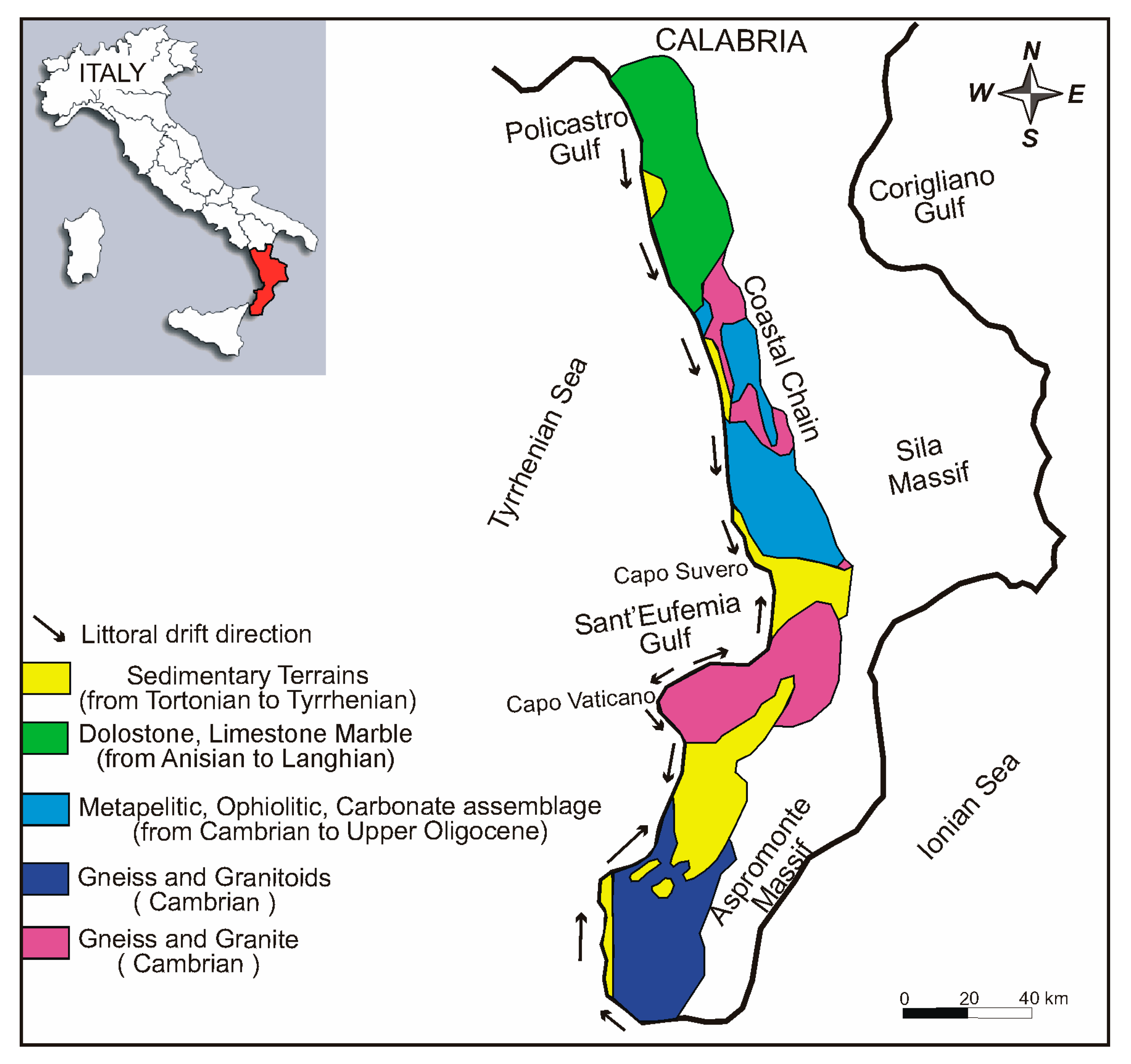
This study’s target is focused on the sediment burial process of Posidonia oceanica and its health state. In this way, we present a possible application of citizen science [35] involving tourist, fishermen and divers in the collection of data for the purpose of monitoring the state of health of Posidonia oceanica meadows in the seawaters of Calabria’s Tyrrhenian coast. Indeed, to recognize the silting process, it was necessary to identify the spatial distribution of hydrographic basins, constituting the sediment source areas, and to know their geological contexts.

2.1. Study Area

Calabria’s Tyrrhenian coast is characterised by a littoral area that mainly extends at the footslopes of an uplifted mountain belt, having elevations higher than 1500 m. In Calabria, the high rates of the uplift process [36,37,38] have been responsible for reliefs with high erosional energy and for the continuous rejuvenation of the hydrographic network, causing a high erosion rate and widespread instability processes [39]. The main geological features of Calabria’s Tyrrhenian area (Figure 1) are represented by rocky masses made up of dolostone, limestone and marble, ranging from Anisian to Langhian in age [40], which outcrop on the northern side of the region.
Cambrian to Upper Oligocene terranes, constituted by metapelitic–ophiolitic–carbonate assemblages, ranging from high- to middle- to low-grade metamorphic [41,42,43] occur on the central part of the Calabria coastal mountains. Cambrian gneiss and granite, which underwent intense weathering processes [44], outcrop in the same area. Finally, on the southern side, gneisses overlain by Cambrian granitoids constitute the Aspromonte massif [45,46], which represents the southernmost area of Calabria. Sedimentary terrains of Tortonian to Tyrrhenian ages, constituted by unconsolidated deposits or by marine arenitic sediments involved in weathering processes [47,48], discontinuously dominate the littoral areas on the southern side. Calabria’s Tyrrhenian coast is characterised by very narrow sandy beaches, interrupted by limited rocky spurs in the northern and central parts of the region. In contrast, rocky cliffs with pocket beaches predominate on the southernmost side. Several researchers demonstrated that the beaches on Calabria’s Tyrrhenian coast suffered a strong erosional process in the last century, showing an average erosion rate equal to 1 m/year, mainly close to river mouths [30,49,50]. The same authors asserted that the human factor, such as the rough urbanisation of littoral areas, is the leading cause of the severe erosion affecting sandy beaches.
The exposition of the coast to wind and sea wave action is from northwest, west and southwest directions. In particular, the mean wave approaching the beach from the northwest direction has a significant offshore height of 2–3 m. Besides, the height waves, with a significant offshore height greater than 5 m, propagate from the west-southwest, where the major geographic fetch occurs. On the northern side of the Calabrian coast, the directions of the littoral currents along Calabria’s Tyrrhenian coast are mainly oriented southward. At the same time, they show frequent direction changes in the central portion. Finally, littoral currents with a northward direction characterise the southern portion of the Tyrrhenian coast (Figure 1) [51].
The geographic position and the mountain range characteristics cause the region to be affected by a variable climate known as Mediterranean climate, which has dry subtropical summers and wet winters. Indeed, during the winter and autumn seasons, the coastal mountains trap the wet air currents moving inland from the Tyrrhenian Sea to produce high-intensity rainfalls. Precipitation values that range from 600–1000 mm/year to more than 1800 mm/year occur in lower and higher elevations of the coastal mountain, respectively [52,53]. Intense downpours, overcoming the historical average rainfall values, are frequent, triggering landslides and flooding in littoral areas [34,54].

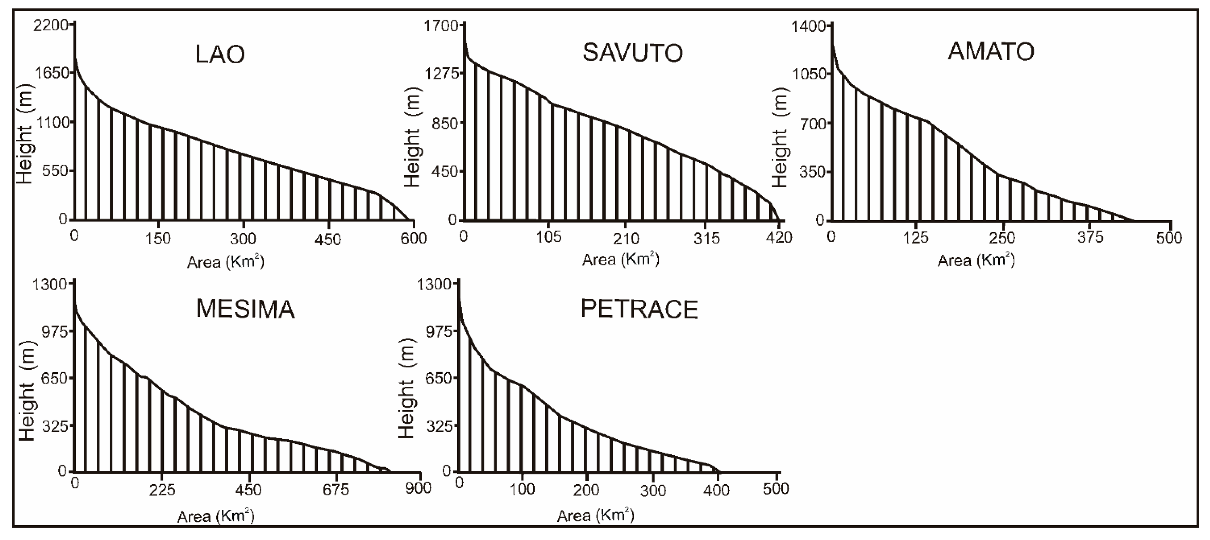
2.2. Geomorphology of the Tyrrhenian Hydrographic Network

On Calabria’s Tyrrhenian side, five river basins have a catchment area larger than 200 km2 (Figure 2 and Table 1). In particular, the surface of these basins ranges from 400 km2 to 800 km2 and is dominated by a great variety of rocky masses that are often strongly weathered [44] and, therefore, easily erodible by the runoff water. A morphometric analysis performed using GIS techniques was used to calculate features, such as hierarchy degree and hypsometric curve. In particular, the drainage network of the five basins was automatically extracted from the DEMs with the support of the Hydrology tool of ArcGIS. This procedure was conducted according to the methodology described by [55]. Subsequently, the drainage lines were hierarchically ordered according to the [56] hierarchical scheme. Hence, the geometrical analysis showed a high degree of hierarchy, with values ranging between 6 and 7 (Table 1), denoting a well-organized fluvial network [57,58]. Equally, the hypsometric curve and hypsometric integral value were also computed using DEM and GIS software, following the methodology described by [59]. These features show the watershed conditions [60,61], demonstrating the stages of landscape evolution and providing an indication of the erosion status of the fluvial basin [57,62]. In the study area, the hypsometric analysis for the five basins showed the presence of two groups that were characterised by the different evolutionary tendencies of the landforms. The first group includes Lao, Savuto and Amato basins, showing a straight shape of hypsometric curve that corresponds to a hypsometric integral value close to 0.5 (Figure 3). This value indicates a mature stage or an equilibrium phase for the drainage network. This entails a vertical erosion of the riverbed, which is balanced by the sediments produced by slope instability [58,60,63].
The Mesima and Petrace rivers belong to the second group, having a hypsometric curve with upward concavity and a hypsometric integral value of less than 0.4 (Figure 3). This value indicates an old stage (known as ‘Monadnock stage’ in [60]) for the drainage networks where slope instability is the dominant state in the basin area.
Basins with a small area are also widespread on Calabria’s Tyrrhenian side. Usually, these small basins have a fluvial axis with a hierarchy degree (Horton’s parameters in [64]) of less than three and a riverbed gradient of over 20%, and these values only decrease notably towards the mouths. These features highlight a high predisposition of these basins to undergo significant landform modifications, giving rise to occasional flash flood events characterised by the fast and abundant flow of water and debris material to the coastal areas [54]. The huge fluvial sediment load is distributed by littoral currents (Figure 1), nourishing the subaerial and nearshore beach systems and contributing to the burial process of Posidonia oceanica.

2.3. Case Study: Marine Regional Park “Scogli di Isca”

In order to assess how the sediment burial level impacts Posidonia oceanica’s health, we conducted a monitoring program in an area of the continental Calabrian Tyrrhenian shelf. The site, chosen as a representative of the entire coast, falls in the Marine Regional Park “Scogli di Isca” (Figure 2). This is part of a Zone of Special Conservation (ZSC-IT9310039) within the Natura 2000 Network, where a large submerged meadow of Posidonia oceanica (Linnaeus) Delile is present. The test area, known as “Fondali Scogli di Isca”, is placed between the coast town of Amantea and the outlet of Verri stream (Figure 2).
This marine hotspot is a Zone of Special Conservation (ZSC) on account of the presence Posidonia beds in the shallow water of (Habitat 1120*, Priority Habitat). The marine site was chosen because it represents a typical example of a clear overlapping between a Marine Regional Park declared by the Calabria Region and a Zone of Special Conservation established by the European Union. Moreover, just in front of the marine protected area there are the outlets of two waterways, the Verri and Catocastro streams, which carry a lot of sediments into the sea that partially covers the meadow of Posidonia oceanica in the shallow seawaters of the park. So, the study area is a good scientific trial zone where it is possible to study the sedimentation process affecting Posidonia beds in depth. The seabed gradient is about equal to 10% and is mainly constituted by sandy deposits with rocky spurs. This stretch of coast is characterised by a narrow sandy beach, where the infrastructure and buildings are close to the coastal fringe or within the backshore area. Heavy erosional processes caused by sea waves affect the coastal area, which was classified as a high-risk zone in a previous study [65].
The quality state of the Posidonia oceanica was evaluated according to the formula of [66], which estimates the state of seagrass leaf mortality as follows:
M (%) = (df − di)/di × 100
where M = mortality rate of Posidonia oceanica leaves, di = starting density of the meadow, and df = final density of the meadow subjected to burial process.
In particular, the state of the Posidonia oceanica meadow was studied in an offshore area at a −12 m depth. The whole monitoring program was conducted as citizen science, in the period 2000–2010 during the spring seasons, in three separate stages. Firstly, the detrital materials and the related burial levels were measured yearly at the base of the seagrass bed using PVC cylinders 35 cm in diameter and height. Thirty box corers were planted into the sea bottom 800 m from the shoreline, close to the upslope limit of the meadow. The box corers were placed at the same depth 20 cm above the seabed and at a distance apart that strictly approached at least 1 m, being spaced one after the other at a linear distance of about 1 m. Secondly, the ecological conditions of the meadow were analysed yearly through diving activities. In this way, a synthetic descriptor based on the seagrass density was used, and the number of leaf shoots per square meter was measured. In order to provide this biological description, diving operators counted the number of leaf shoots in grids of 40 cm per side. The count was repeated 20 times on different experimental plots in the examined station. Then, the results were extrapolated to an area of one square meter. Based on the results achieved by the survey program, the health state of the meadow was ascribed. Thirdly, the grain size distribution of the detrital material was analysed. In this regard, we chose to use the box corer located in the most central position of the studied area to analyze the sediment samples via grain size distribution analysis. The aim of the research was to study the possible evolution of sediment texture in order to analyse its influence on the variations displayed by Posidonia meadows. Therefore, the values of the average sediment size of submerged beach were collected and compared for the 2000–2010 period. This approach was used to analyse whether the proportions of clay, silt, and sand could vary from one year to another and if these changes could affect the health of Posidonia bed. The analysed samples were preliminarily washed using H2O2 to remove clays and organic matter. They were then air-dried and sieved. The 0.25–0.50 mm size fraction was selected in order to prepare thin sections that could be analysed to obtain the petrographic composition of the medium sand in order to study the provenance of the sediments. Each thin section was etched and stained using HF and sodium cobaltinitrite for feldspar grain identification.

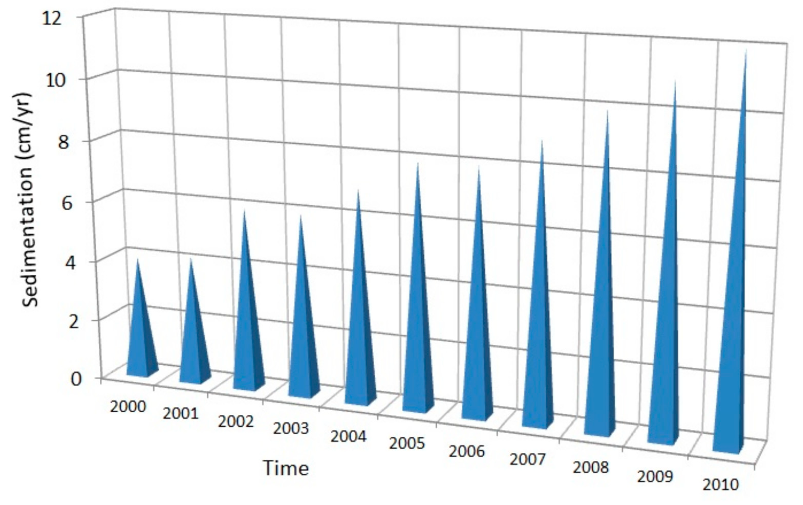
3. Results and Discussion

The analysis of detritus collected in the offshore area and the study of the geomorphic equilibrium state of the fluvial basins are important aspects in assessing the health state of the Posidonia oceanica bed and its sensibility to silting processes. Indeed, the geomorphological condition of the catchment gives valuable information on its landform evolution in terms of erosion processes and the potential abundance of detritus material carried in shelf areas. The subsequent study of grain size and the petrographic composition of detritus supplied helpful information on the material involved in the silting processes of Posidonia oceanica in the Tyrrhenian bays. Working within this scope, the geomorphological analysis of the main fluvial basins on Calabria’s Tyrrhenian flank denotes the strong predisposition of the slopes to erosion processes. Indeed, steep slopes affected by widespread instability phenomena [34,48,67,68,69] characterise the mountainous landscape in the Tyrrhenian area. These conditions produce a potentially high tendency of the Tyrrhenian basins to supply abundant debris material in the shelf areas, causing a high potential risk for the Posidonia meadow’s survival. Indeed, Posidonia oceanica suffers a great deal from the silting process, which causes a high mortality rate [66,70]. The direct consequence is that the Posidonia meadows on the Tyrrhenian Calabria coast are missing in the shelf areas close to the mouths of all great basins (Figure 2), where a significant amount of sediment is carried. Anyway, other abiotic factors, such as sunlight, salinity and temperature, can influence the state of health of Posidonia oceanica meadows. It is well known that the species requires high sunlight levels for its photosynthetic activity and that it is very sensitive to any variations in water clarity [25], which are mainly caused by high sedimentation rates. Additionally, this marine seagrass is very responsive to the changes in seawater salinity caused by the fluvial discharge also responsible for the increase in nutrient and sediment runoff, a factor which could affect the meadows’ survival. However, the hypothesis cannot be excluded that pollution, human activities and strong erosion processes also affect the coast and can contribute to the loss of Posidonia meadows, as discussed by several authors [6,8,28,71,72,73].

The Meadows of Posidonia oceanica on Calabria’s Tyrrhenian Coast

The survey program was carried out between 2000 and 2010 through report cards designed by the regional division of the World Wildlife Fund of Italy. These forms were distributed to local fishermen, scuba diving centers and tourist organizations in order to provide an easy and handy tool for assessing the distribution of Posidonia oceanica meadows in the Tyrrhenian waters of Calabria. Then, the diving logs, once uploaded, were verified and examined to check the coordinates, extension and upper/lower limits of the meadow. Finally, all the information was registered in a data base from a local dive center located in the regional division of the World Wildlife Fund of Italy. The regional survey of Posidonia oceanica meadows highlights the presence of 13 meadows (Table 2 and Figure 2). These are concentrated in the northern and southern waters of Calabria’s Tyrrhenian seaside, except for the only one localated in its central coastal area, which is placed on the seabed of the Marine Regional Park “Scogli di Isca” [30]. Most of these meadows are located (Figure 2) in shallow waters ranging from 2 to 20 m in depth. In contrast, the only three meadows in deep waters below 20 m in depth are located in the coastal areas of Briatico, Santa Domenica and Capo Vaticano (Vibo Valentia province, southern Italy). All these seagrasses reach a global area of 544.97 hectares; amongst them, eight are based on mobile substrates, and five are on hard bottoms, corresponding to 61.54% and 38.46% of the whole, respectively.
The distribution of the Posidonia meadows highlights that they are located in the coastal stretches dominated by small fluvial basins. These have areas of less than 200 km2 but are able to carry high solid loads in shelf areas during heavy downpours [34,54]. In the pristine waters of the Marine Regional Park “Scogli di Isca” (Figure 2), it was decided, in 2000, to evaluate the effects of silting processes on a Posidonia oceanica meadow. This was first performed in good ecological conditions (Figure 4a). The monitoring program in the “Scogli di Isca” site highlighted that at the beginning of the sampling in 2000–2002, an average silting rate of 4.5 cm/year was observed. At this silting rate, half of the meadow died in this period. However, the plants were partially able to reply against silting processes thanks to the physiological response of the roots, which were able to counteract the high rates of sedimentation with a marked lengthening of their orthotropic rhizomes at a growth rate of about 1.5 cm/year, thus protecting the shoot apical meristems (SAM) of their leaves. In the following period, the silting trend increased year by year, reaching, in 2010, an impressive rate of 12 cm/year (Figure 4b). This sedimentary overloading at the base of the meadow caused a marked reduction in the ability of the plants to respond against the burial process through the vertical growth of their rhizomes. It is well known in the scientific literature [74] that the species is characterised by the low elongation rate of their orthotropic rhizomes, ranging from 0.5 to 1.5 cm/year. So, the health state of Posidonia oceanica beds appears to be strictly connected to burial dynamics because the species is very susceptible to silting processes [75,76].
The high sedimentary loading recorded in 2010 was probably caused by heavy rainfall values achieved in the period 2009–2010 in the Calabria region. Many historical average precipitation rates were overcome during this period, and widespread landslides and flooding occurred [39,54,77], causing a high rate of sediment transport in coastal areas. The high sediment load caused an excessive silting rate in shelf areas, decreasing the plants’ photosynthetic ratio. Therefore, the Posidonia oceanica meadow has suffered from a high sedimentary rate, reducing its leaf density. Indeed, at the end of the survey period, in 2009/2010, a burial level of 12 cm/year caused an impressive necrosis of the leaves’ meristems, leading to a sharp increase in shoot mortality (Figure 5).
In this critical condition, the vertical growth of rhizomes stopped, and the plants, with rates of mortality fluctuating from 90% to 100%, began to decay, causing mortality and the complete disappearance of the meadow. So, it is possible to assume that for every increase in centimeter/year in sedimentation rate, the seagrass mortality rate increases by ~8.4% (Figure 6). This condition highlights the close connection between sedimentation processes and mortality rates, which represent the key factors affecting the meadows’ survival.
The grain size analysis, performed on the collected sediment samples, allowed us to define the granular distribution. The analysis showed a unimodal grain size distribution dominated by the sand fraction. In particular, the shoreface samples collected at a depth of −12 m exhibit different grain size fractions, which mainly span between coarse and fine classes. A majority abundance was observed in the medium sand fraction (size 0.5 mm–0.25 mm) class, where values between 50% and 60% in weight were achieved (Figure 7). A minor percentage of weight (20–30%) is constituted by a coarse sandy fraction due to the high hydrodynamic energy of the sea waves [78], enabling transport processes of the high fraction at elevated depths. The grain size features are very important to assessing the environmental conditions of Posidonia oceanica species, which are highly vulnerable to sediment-level changes [79,80].
In particular, the granular analysis of sediments supplies valuable information on the type of sediment fraction that could bury the meadows and thus cause their mortality. Usually, in the Mediterranean area, the seabed zones exposed to Posidonia oceanica colonisation are dominated by coarse and/or medium-grained sediments [81,82,83], testifying that the grain size values collected in the study area are coherent with ones shown in previous studies. Finally, the monitoring of the sedimentary textures from 2000 to 2010 showed that no significant changes were observed in the average grain size sampled.
The petrographic composition, observed through thin sections of the sand samples, showed that the detritus was derived mostly from metamorphic-source rock lithotypes (schists + phyllites). In particular, different abundances of metamorphiclastic sandy grains were found. We arranged the grains from the most to least abundant: schistose lithic fragments, phyllitic lithic fragments, gneissose rock fragments and serpentinite. The petrographic assemblage allowed us to identify the signature of distinct structural domains outcropping in the coastal range and carried in a shelf area by the outflow of the drainage network. The recognised sand composition shows a mineral assemblage comparable to the one identified by several authors in the same area [68,84,85].
The negative conditions of the Posidonia beds in the tested area were also found in many other meadows scattered all along Italian coasts [10,70,86,87,88,89] and in other coastal waters of Mediterranean Sea, showing the degree of weakness of Posidonia oceanica meadows towards sedimentary dynamics [8,66,90,91,92]. Similar conditions linked to the increased loading of sediments were also observed in some littoral regions of Southern Australia [7] and in different seagrass beds in North American waters [7]. Since the progressive destruction of Posidonia oceanica meadows could bring about the disappearance of some endemic species that live in the same coastal ecosystem, it is necessary to include such meadows in monitoring programs and restoration projects worldwide and increase public awareness.
The paper highlights the great importance of studying the relationships between two different environments in coastal areas, such as fluvial basins with their geomorphological features, and the potential negative impacts they generate on the biological ecosystems in the shelf area from a multidisciplinary perspective. This connection highlights the growing need for joint coastal area and river basin management as these areas still receive negative attention from society and local authorities [65]. Therefore, the integration of coastal areas and river basins into the same environment becomes an urgent need for sound regional planning, as established in the “Integrated Coastal Area and River Basin Management” pattern (ICARM process, in ref. [93]). The close relationship argued in this paper proves that the principle of a “river continuum concept” [94], able to regard catchments and coasts as a single system, should be reinforced [95,96,97] to preserve the coastal ecosystems. In other words, it is a crucial necessity to consider coastal, marine and riverine systems in the same landscape unit so that we can envisage a new kind of coastal management based on the linkages between shelf and catchment areas [30,65].

4. Conclusions

Marine pollution via the silting process is one of the main factors causing the regression of Posidonia oceanica meadows along Calabria’s Tyrrhenian coasts. If it is to be performed appropriately, the study of the silting process must include the analysis of the composition and provenance of the detritus material. Thus, this research was first based on an overall geomorphological study of the main fluvial basins of Calabria’s Tyrrhenian coast, which represents the sediment source areas. Based on the hypsometric analysis, the geomorphological study displayed a good predisposition of the fluvial basin areas to undergo erosion processes and to furnish abundant debris materials in shelf areas, which can threaten the state of health of Posidonia bed. For these reasons, a monitoring program was planned in 2000–2010 to assess the increasing burial level at the base of a Posidonia oceanica meadow. Several detritus samples were analysed in order to study their composition and provenance. The Marine Regional Park of Isca (Calabria, southern Italy) test area showed that the Posidonia oceanica species began to suffer from silting processes at about 4–5 cm/year sedimentation rates. In these critical conditions, the mortality rate of the leaves approached a level of about 50% of the whole. Under an increasing burial trend, the vegetative growth was partially limited by the shot apical meristem of the leaves, leading to a gradual decrease in the density of the meadow. In 2010, the silting process increased its heavy impact, reaching a sedimentation rate of 12 cm/year and affecting the survival of the meadow. SAM were entirely inhibited, causing the leaves’ death and the seagrass’ progressive decay. The decay of this endemic species could affect the sensitive balance of some coastal ecosystems, causing a severe loss in marine biodiversity over time. The abundant sediment causing the silting process is mainly constituted by a medium sand fraction and originates from the Calabrian coastal chain by way of the numerous small river basins.
The paper highlights the crucial importance of combining complementary scientific disciplines to study shelf and river basins, which should be enclosed in the same landscape unit for better coastal management. This strategy is essential to efforts to find adequate plans to limit the growing trend of silting processes affecting Posidonia oceanica meadows and, at last, prevent their possible disappearance.

Author Contributions

Conceptualization, F.I. and N.C.; methodology: G.P. and N.C.; software: G.P.; Validation: F.I. and N.C.; formal analysis: G.P.; Investigation: N.C.; data curation: F.I., G.P. and N.C.; writing-original draft preparation: F.I. and N.C.; writing-review and editing: F.I. and N.C.; visualization: F.I. and N.C.; supervision: F.I. and N.C.; project administration: F.I. and N.C.; funding acquisition: F.I. All authors have read and agreed to the published version of the manuscript.

Funding

This study was funded by MIUR (Ministero dell’Istruzione, dell’Università e della Ricerca), MIUR ex 60% fund (2019 year) to Ietto Fabio.

Institutional Review Board Statement

No animal testing was performed during this study.

Informed Consent Statement

Permits for sampling and observational field studies are not applicable.

Data Availability Statement

All data generated or analysed during this study are included in this published article.

Acknowledgments

The authors are indebted to four reviewers for their very constructive comments aimed to improve the manuscript.

Conflicts of Interest

The authors declare no conflict of interest.

References

  1. Parthasarathy, A.; Natesan, U. Coastal vulnerability assessment: A case study on erosion and coastal change along Tuticorin, Gulf of Mannar. Nat. Hazards 2015, 75, 1713–1729. [Google Scholar] [CrossRef]
  2. Pimm, S.L.; Raven, P. Extinction by numbers. Nature 2000, 403, 843–845. [Google Scholar] [CrossRef] [PubMed]
  3. Zaitsev, Y.P. Littoral concentration of life in the Black Sea and coastal management requirements. J. Black Sea/Mediterr. Environ. 2006, 12, 113–128. [Google Scholar]
  4. Shadrin, N.V.; Mironov, S.S.; Ferat, T.A. Interrelations between the losses of sandy beaches and biodiversity in seas: Case of the Bakalskaya Spit (Crimea, Ukraine, Black Sea). Turk. J. Fish. Aquat. Sci. 2012, 12, 411–415. [Google Scholar] [CrossRef]
  5. Jordà, G.; Marbà, N.; Duarte, C. Mediterranean seagrass vulnerable to regional climate warming. Nat. Clim. Change 2012, 2, 821–824. [Google Scholar] [CrossRef]
  6. Marbà, N.; Díaz-Almela, E.; Duarte, C.M. Mediterranean seagrass (Posidonia oceanica) loss between 1842 and 2009. Biol. Conserv. 2014, 176, 183–190. [Google Scholar] [CrossRef]
  7. Orth, R.J.; Carruthers, T.J.; Dennison, W.C.; Duarte, C.M.; Fourqurean, J.W.; Heck, K.L.; Hughes, A.R.; Kendrick, G.A.; Kenworthy, W.J.; Olyarnik, S.; et al. A global crisis for seagrass ecosystems. Bioscience 2006, 56, 987–996. [Google Scholar] [CrossRef]
  8. Boudouresque, C.F.; Bohomme, P.; Charbonnel, E.; Diviacco, G.; Meinesz, A.; Pergent, G.; Pergent-Martini, C.; Ruitton, S.; Tunesi, L. Protection and Conservation of Posidonia Oceanica Meadows; RAMOGE and RAC/SPA Publishers: Tunis, Tunisia, 2012; p. 202. [Google Scholar]
  9. Fonseca, M.S. The role of seagrasses in nearshore sedimentary processes: A review. In Estuarine Shores: Hydrological, Geomorphological and Ecological Interactions; Blackwell: Boston, MA, USA, 1996; pp. 261–286. [Google Scholar]
  10. De Falco, G.; Ferrari, S.; Cancemi, G.; Baroli, M. Relationship between sediment distribution and Posidonia oceanica seagrass. Geo-Mar. Lett. 2000, 20, 50–57. [Google Scholar] [CrossRef]
  11. Boero, F.; Chessa, L.; Chimenz, C.; Fresi, E. The zonation of Epiphytic Hidroids on the Leaves of Some Posidonia oceanica (L.) Delile Beds in the Central Mediterranean. Mar. Ecol. 1985, 6, 27–33. [Google Scholar] [CrossRef]
  12. Kocak, F.; Aydin-Onen, S. Epiphytic bryozoan community of Posidonia oceanica (L.) Delile leaves in two different meadows at disturbed and control locations. Mediterr. Mar. Sci. 2014, 15, 390–397. [Google Scholar] [CrossRef]
  13. Lepoint, G.; Mouchette, O.; Pelaprat, C.; Gobert, S. An ecological study of Electra posidoniae Gautier, 1954 (Cheilostomata, Anesca), a bryozoan epiphyte found solely on the seagrass Posidonia oceanica (L.) Delile, 1813. Belg. J. Zool. 2014, 144, 51–63. [Google Scholar]
  14. Borum, J.; Duarte, C.M.; Krause-Jensen, D.; Greve, T.M. European Seagrasses: An Introduction to Monitoring and Management; The M & MS Project: Copenhagen, Denmark, 2004; p. 95. [Google Scholar]
  15. Pergent, G.; Semroud, R.; Djellouli, A.; Langar, H.; Duarte, C. The IUCN Red List of Threatened Species, Version 2020-2. 2010. Available online: www.iucnredlist.org (accessed on 26 November 2020).
  16. Holon, F.; Boissery, P.; Guilbert, A.; Freschet, E.; Deter, J. The impact of 85 years of coastal development on shallow seagrass beds (Posidonia oceanica L. (Delile)) in South Eastern France: A slow but steady loss without recovery. Estuar. Coast. Shelf Sci. 2015, 165, 204–212. [Google Scholar] [CrossRef]
  17. Roca, G.; Romero, J.; Columbu, S.; Farina, S.; Pagès, J.F.; Gera, A.; Inglis, G.; Alcoverro, T. Detecting the impacts of harbour construction on a seagrass habitat and its subsequent recovery. Ecol. Indic. 2014, 45, 9–17. [Google Scholar] [CrossRef]
  18. Telesca, L.; Belluscio, A.; Criscoli, A.; Ardizzone, G.; Apostolaki, E.T.; Fraschetti, S.; Gristina, M.; Knittweis, L.; Martin, C.S.; Pergent, G.; et al. Seagrass meadow (Posidonia oceanica) distribution and trajectories of change. Sci. Rep. 2015, 5, 12505. [Google Scholar] [CrossRef]
  19. De Los Santos, C.B.; Krause-Jensen, D.; Alcoverro, T.; Marbà, N.; Duarte, C.M.; van Karwijk, M.M.; Pèrez, M.; Romero, J.; Sanchez-Lizaso Jl Roca, G.; Jankowska, E.; et al. Recent trend reversal for declining European seagrass meadows. Nat. Commun. 2019, 10, 3356. [Google Scholar] [CrossRef] [PubMed]
  20. Pergent-Martini, C.; Monnier, B.; Lehmann, L.; Barralon, E.; Pergent, G. Major regression of Posidonia oceanica meadows in relation with recreational boat anchoring: A case study from Sant’Amanza bay. J. Sea Res. 2022, 188, 102258. [Google Scholar] [CrossRef]
  21. Blanco-Murillo, F.; Fernández-Torquemada, Y.; Garrote-Moreno, A.; Sáez, C.A.; Sánchez-Lizaso, J.L. Posidonia oceanica L. (Delile) meadows regression: Long-term affection may be induced by multiple impacts. Mar. Environ. Res. 2022, 174, 105557. [Google Scholar] [CrossRef]
  22. Litsi-Mizan, V.; Ejthymadis, P.T.; Gerakaris, V.; Serrano, O.; Tsapakis, M.; Apostolaki, E.T. Decline of seagrass (Posidonia oceanica) production over two decades in the face of warming of the Eastern Mediterranean Sea. New Phythol. 2023, 1–12. [Google Scholar] [CrossRef]
  23. Marbà, N.; Duarte, C.M. Rhizome elongation and seagrass clonal growth. Mar. Ecol. Prog. Ser. 1998, 174, 269–280. [Google Scholar] [CrossRef]
  24. Gaglianone, G.; Brandano, M.; Mateu-Vicens, G. The sedimentary facies of Posidonia oceanica seagrass meadows from the central Mediterranean Sea. Facies 2017, 63, 28. [Google Scholar] [CrossRef]
  25. Boudouresque, C.F.; Meinesz, A. Decouvert de l’herbier de posidonie. Cah. Parc Natl. Port Cross Fr. 1982, 4, 1–81. [Google Scholar]
  26. Gacia, E.; Duarte, C.M.; Marbà, N.; Terrados, J.; Kennedy, H.; Fortes, M.D.; Tri, N.H. Sediment deposition and production in SE-Asia seagrass meadows. Estuar. Coast. Shelf Sci. 2003, 56, 909–919. [Google Scholar] [CrossRef]
  27. Gacia, E.; Duarte, C.M. Sediment retention by a Mediterranean Posidonia oceanica meadow: The balance between deposition and resuspension. Estuar. Coast. Shelf Sci. 2001, 52, 505–514. [Google Scholar] [CrossRef]
  28. Boudouresque, C.F.; Bernard, G.; Pergent, G.; Shili, A.; Verlaque, M. Decline of Mediterranean seagrasses caused by natural processes and anthropogenic disturbances and stress: A critical review. Bot. Mar. 2009, 52, 395–418. [Google Scholar] [CrossRef]
  29. W.W.F. Living Planet Report 2014, Summary; W.W.F.: Gland, Switzerland, 2014; pp. 1–35. [Google Scholar]
  30. Cantasano, N. Sedimentazione nelle praterie di Posidonia oceanica (L.) Delile lungo le coste tirreniche calabresi. Biol. Ital. 2017, 47, 51–58. (In Italian) [Google Scholar]
  31. D’Alessandro, L.; Davoli, E.; Lupia Palmieri, E.; Raffi, R. Natural and anthropogenic factors of the recent evolution of the Calabria beaches. In Applied Geomorphology: Theory and Practice; Allison, R.J., Ed.; Wiley: New York, NY, USA, 2002; Volume 22, pp. 397–427. [Google Scholar]
  32. Ietto, F.; Cantasano, N.; Pellicone, G. A New Coastal Erosion Risk Assessment Indicator: Application to the Calabria Tyrrhenian Littoral (Southern Italy). Environ. Process. 2018, 5, 201–223. [Google Scholar] [CrossRef]
  33. Sorriso-Valvo, M.; Sylvester, A.G. The relationship between geology and landforms along a coastal mountain front, northern Calabria, Italy. Earth Surf. Process. Landf. 1993, 18, 257–273. [Google Scholar] [CrossRef]
  34. Antronico, L.; Borrelli, L.; Coscarelli, R. Recent damaging events on alluvial fans along a stretch of the Tyrrhenian coast of Calabria (southern Italy). Bull. Eng. Geol. Environ. 2017, 76, 1399–1416. [Google Scholar] [CrossRef]
  35. Bonney, R.; Shirk Jl Phillips, T.B.; Wiggins, A.; Ballard, H.L.; Miller-Rushing, A.J.; Parrish, J.K. Citizen science. Next steps for citizen science. Science 2014, 343, 1436–1437. [Google Scholar] [CrossRef]
  36. Ghisetti, F. Upper Pliocene–Pleistocene Uplift Rates as Indicators of Neotectonic Pattern: An Example from Southern Calabria (Italy). Z. Geomorphol. 1981, 40, 93–118. [Google Scholar]
  37. Ietto, F.; Bernasconi, M.P. The Cliff Bordering the Northwestern Margin of the Mesima Basin (Southern Calabria) is of Pleistocene Age. Geogr. Fis. Dinam. Quart. 2005, 28, 205–210. [Google Scholar]
  38. Antonioli, F.; Ferranti, L.; Fontana, A.; Amorosi, A.; Bondesan, A.; Braitenberg, C.; Dutton, A.; Fontolan, G.; Furlani, S.; Lambeck, K.; et al. Holocene Relative Sea-Level Changes and Vertical Movements along the Italian and Istrian Coastlines. Quat. Int. 2009, 206, 102–133. [Google Scholar] [CrossRef]
  39. Antronico, L.; Coscarelli, R.; De Pascale, F.; Muto, F. Geo-hydrological risk perception: A case study in Calabria (Southern Italy). Int. J. Disaster Risk Reduct. 2017, 25, 301–311. [Google Scholar] [CrossRef]
  40. Scandone, P. Structure and evolution of the Calabrian Arc. Earth Evol. Sci. 1982, 3, 172–180. [Google Scholar]
  41. Amodio-Morelli, L.; Bonardi, G.; Colonna, V.; Dietrich, D.; Giunta, G.; Ippolito, F.; Liguori, V.; Lorenzoni, S.; Paglionico, A.; Perrone, V.; et al. L’Arco Calabro-Peloritano nell’orogene appenninico-maghrebide. Soc. Geol. Ital. Mem. 1976, 17, 1–60. (In Italian) [Google Scholar]
  42. Carrara, A.; Zuffa, G.G. Alpine structures in northwestern Calabria, Italy. Geol. Soc. Am. Bull. 1976, 87, 1229–1246. [Google Scholar] [CrossRef]
  43. Lorenzoni, S.; Orsi, G.; Zanettin Lorenzoni, E. Metallogenesis in the tectonic units and lithogenetic environments of Calabria (southern Italy). Mem. Soc. Geol. Italy 1983, 35, 411–428. [Google Scholar]
  44. Borrelli, L.; Perri, F.; Critelli, S.; Gullà, G. Characterization of granitoid and gneissic weathering profiles of the Mucone River basin (Calabria, southern Italy). Catena 2016, 113, 325–340. [Google Scholar] [CrossRef]
  45. Bonardi, G.; Compagnoni, R.; Messina, A.; Perrone, V.; Russo, S.; De Francesco, A.M.; Del Moro, A.; Platt, J. Sovrimpronta metamorfica alpina nell’unità dell’Aspromonte (settore meridionale dell’Arco Calabro–Peloritano). Bolletino Soc. Geol. Ital. 1992, 111, 81–108. (In Italian) [Google Scholar]
  46. Graeßner, T.; Schenk, V. Low-pressure metamorphism of Palaeozoic pelites in the Aspromonte, southern Calabria: Constraints for the thermal evolution in the Calabrian crustal cross-section during the Hercynian orogeny. J. Metamorph. Geol. 1999, 17, 157–172. [Google Scholar] [CrossRef]
  47. Ietto, F.; Le Pera, E.; Perri, F. Weathering of the ‘Rupe di Tropea’ (southern Calabria): Consolidation criteria and erosion-rate estimate. Rend. Online Soc. Geol. Italy 2013, 24, 178–180. [Google Scholar]
  48. Ietto, F.; Perri, F.; Miriello, D.; Ruffolo, S.A.; Laganà, A.; Le Pera, E. Epoxy resin for the slope consolidation intervention on the Tropea sandstone cliff (southern Calabria, Italy). Geoheritage 2018, 10, 287–300. [Google Scholar] [CrossRef]
  49. D’Alessandro, F.; Tomasicchio, G.R.; Frega, F.; Carbone, M. Design and management aspects of a coastal protection system. A case history in the South of Italy. J. Coast. Res. Suppl Spec. Issue SI 2011, 64, 492–495. [Google Scholar]
  50. Ietto, F.; Le Pera, E.; Caracciolo, L. Geomorphology and sand provenance of the Tyrrhenian coast between capo Suvero and Gizzeria (Calabria, southern Italy). Rend. Online Soc. Geol. Italy 2012, 21, 487–488. [Google Scholar]
  51. Lupia Palmieri, E.; Raffi, R. Atlante delle spiagge italiane: Dinamismo—Tendenza evolutiva—Opere umane. In Sheets, Scales 1: 100,000; Fierro, G., Ed.; S.EL.CA.: Firenze, Italy, 1983; p. 108. (In Italian) [Google Scholar]
  52. Caloiero, D. Le Precipitazioni in Calabria Nel Cinquantennio 1921-70 e Carta Delle Isoiete Alla Scala 1: 500.000; CNR-IRPI Istituto di Ricerca per la Protezione Idrogeologica: Cosenza, Italy, 1975. (In Italian) [Google Scholar]
  53. Petrucci, O.; Chiodo, G.; Caloiero, D. Eventi Alluvionali in Calabria nel Decennio 1971–1980; GNDCI, Rubbettino Arti Grafiche, Soveria Mannelli: Catanzaro, Italy, 1996; p. 142. (In Italian) [Google Scholar]
  54. Ietto, F.; Perri, F. Flash flood event (october 2010) in the Zinzolo catchment (Calabria, southern Italy). Rend. Online Soc. Geol. Italy 2015, 35, 170–173. [Google Scholar] [CrossRef]
  55. Peckham, R.J.; Jordan, G. Digital Terrain Modeling. Development and Applications in a Policy Support Environment. In Series: Lecture Notes in Geoinformation and Cartography; Springer: Berlin, Germany, 2007. [Google Scholar]
  56. Strahler, A.N. Quantitative Geomorphology of Drainage Basins and Channel Networks. In Handbook of Applied Hydrology; Chow, V., Ed.; McGraw Hill: New York, NY, USA, 1964; pp. 439–476. [Google Scholar]
  57. Centamore, E.; Ciccacci, S.; Del Monte, M.; Fredi, P.; Lupia Palmieri, E. Morphological and structural arrangement of North-eastern Abruzzo (Central Italy). Geomorphology 1996, 16, 127–137. [Google Scholar] [CrossRef]
  58. Ciccacci, S.; D’Alessandro, L.; Fredi, P.; Lupia Palmieri, E. Relation between morphometric characteristics and denudation processes in some drainage basins of Italy. Z. Fuer Geomorphol. 1992, 36, 53–67. [Google Scholar] [CrossRef]
  59. Pike, R.J.; Wilson, S.E. Elevation-Relief Ratio, Hypsometric Integral and Geomorphic Area-Altitude Analysis. Geol. Soc. Am. Bull. 1971, 82, 1079–1084. [Google Scholar] [CrossRef]
  60. Strahler, A.N. Hypsometric (Area-Altitude) analysis of erosional topography. Geol. Soc. Am. Bull. 1952, 63, 117–142. [Google Scholar] [CrossRef]
  61. Ritter, D.F.; Kochel, R.C.; Miller, J.R. Process Geomorphology; McGraw Hill: Boston, MA, USA, 2002. [Google Scholar]
  62. Weissel, J.K.; Pratson, L.F.; Malinverno, A. The length scaling properties of topography. J. Geophys. Res. 1994, 99, 13997–14012. [Google Scholar] [CrossRef]
  63. Willgoose, G.; Hancock, G. Revisiting the hypsometric curve as an indicator of form and process in transport-limited catchment. Earth Surf. Process. Landf. 1998, 23, 611–623. [Google Scholar] [CrossRef]
  64. Horton, R.E. Erosional development of streams and their drainage basin; hydrophysical approach to quantitative morphology. Geol. Soc. Am. Bull. 1945, 56, 275–370. [Google Scholar] [CrossRef]
  65. Cantasano, N.; Pellicone, G.; Ietto, F. The Coastal Sustainability Standard method: A case study in Calabria (Southern Italy). Ocean. Coast. Manag. 2020, 183, 104962. [Google Scholar] [CrossRef]
  66. Cabaço, S.; Santos, R.; Duarte, C.M. The impact of sediment burial and erosion on seagrasses: A review. Estuar. Coast. Shelf Sci. 2008, 79, 354–356. [Google Scholar] [CrossRef]
  67. Sorriso-Valvo, M.; Antronico, L.; Le Pera, E. Controls on modern fan morphology in Calabria, Southern Italy. Geomorphology 1998, 24, 169–187. [Google Scholar] [CrossRef]
  68. Le Pera, E.; Sorriso-Valvo, M. Weathering, erosion and sediment composition in a high-gradient river, Calabria, Italy. Earth Surf. Process. Landf. 2000, 25, 277–292. [Google Scholar] [CrossRef]
  69. Conforti, M.; Ietto, F. Modeling shallow landslide susceptibility and assessment of the relative importance of predisposing factors, through a gis-based statistical analysis. Geosciences 2021, 11, 333. [Google Scholar] [CrossRef]
  70. Badalamenti, F.; Carlo, D.G.; D’Anna, G.; Gristina, M.; Toccaceli, M. Effects of dredging activities on population dynamics of Posidonia oceanica (L.) Delile in the Mediterranean Sea: The case study of Capo Feto. Hydrobiologia 2006, 555, 253–261. [Google Scholar] [CrossRef]
  71. Thomas, F.; Turon, X.; Romero, J. Seasonal and small-scale spatial variability of herbivory pressure on the temperate seagrass Posidonia oceanica. Mar. Ecol. Prog. Ser. 2005, 301, 95–107. [Google Scholar] [CrossRef]
  72. Pergent, G.; Bazairi, H.; Bianchi, C.N.; Boudouresque, C.F.; Buia, M.C.; Calvo, S.; Clabaut, P.; Harmelin-Vivien, M.; Mateo, M.A.; Montefalcone, M.; et al. Climate change and Mediterranean seagrass meadows: A synopsis for environmental managers. Mediterr. Mar. Sci. 2014, 15, 462–473. [Google Scholar] [CrossRef]
  73. Tuya, F.; Ribeiro-Leite, L.; Arto-Cuesta, N.; Coca, J.; Haroun, R.; Espino, F. Decadal changes in the structure of Cymodocea nodosa seagrass meadows: Natural vs. human influences. Estuar. Coast. Shelf Sci. 2014, 137, 41–49. [Google Scholar] [CrossRef]
  74. de Grissac, A.J.; Boudouresque, C.F. Ròles des herbiers de phanérogames marines dan le mouvements des sediments cȏtiers: Les herbiers a Posidonia oceanica. Colloq. Fr.-Jpn. D’oceanogr. 1985, 1, 143–151. [Google Scholar]
  75. Boudouresque, C.F.; de Grissac, A.J.; Meinesz, A. Relations entre la sedimentation et l’allongement des rhizomes orthotropes de Posidonia oceanica dans la baie d’Elbu (Corse). In International Workshop on Posidonia Occeanica Beds; Boudouresque, C.F., de Grissac, A.J., Olivier, J., Eds.; GIS Posidonie Publishers: Marseille, France, 1984; pp. 185–191. [Google Scholar]
  76. Vermaat, J.E.; Agawin, N.S.R.; Duarte, C.M.; Enriquez, S.; Fortes, M.D.; Uri, J.S.; van Vierssen, W. The capacity of seagrasses to survive increased turbidity and siltation: The significance of growth forms and light use. Ambio 1997, 26, 499–504. [Google Scholar]
  77. Petrucci, O.; Pasqua, A.A.; Gullà, G. Landslide damage assessment using the Support Analysis Framework (SAF): The 2009 landsliding event in Calabria (Italy). Adv. Geosci. 2010, 26, 13–17. [Google Scholar] [CrossRef]
  78. Morrone, C.; Ietto, F. Shoreline evolution and modern beach sand composition along a coastal stretch of the Tyrrhenian Sea (southern Italy). J. Palaeogeogr. 2021, 10, 7. [Google Scholar] [CrossRef]
  79. Montefalcone, M.; Parravicini, V.; Vacchi, M.; Albertelli, G.; Ferrari, M.; Morri, C.; Bianchi, C.N. Human influence on seagrass habitat fragmentation in NW Mediterranean Sea. Estuar. Coast. Shelf Sci. 2010, 86, 292–298. [Google Scholar] [CrossRef]
  80. Abadie, A.; Gobert, S.; Bonacorsi, M.; Lejeune, P.; Pergent, G.; Pergent-Martini, C. Marine space ecology and seagrasses. Does patch type matter in Posidonia oceanica seascapes? Ecol. Indic. 2015, 57, 435–446. [Google Scholar] [CrossRef]
  81. Papadimitriou, S.; Kennedy, H.; Kennedy, D.P.; Duarte, C.M.; Marbà, N. Sources of organic matter in seagrass-colonized sediments: A stable isotope study of the silt and clay fraction from Posidonia oceanica meadows in the western Mediterranean. Org. Geochem. 2005, 36, 949–961. [Google Scholar] [CrossRef]
  82. Gobert, S.; Lepoint, G.; Pelaprat, C.; Remy, F.; Lejeune, P.; Richir, J.; Abadie, A. Temporal evolution of sand corridors in a Posidonia oceanica seascape: A 15-years study. Mediterr. Mar. Sci. 2016, 17, 777–784. [Google Scholar] [CrossRef]
  83. Bonamano, S.; Piazzolla, D.; Scanu, S.; Mancini, E.; Madonia, A.; Piermattei, V.; Marcelli, M. Modelling approach for the evaluation of burial and erosion processes on Posidonia oceanica meadows. Estuar. Coast. Shelf Sci. 2021, 254, 107321. [Google Scholar] [CrossRef]
  84. Le Pera, E.; Critelli, S. Sourceland controls on the composition of beach and fluvial sand of the Tyrrhenian coast of Calabria, Italy: Implications for actualistic petrofacies. Sediment. Geol. 1997, 110, 81–97. [Google Scholar] [CrossRef]
  85. Le Pera, E.; Mongelli, G.; Morelli, F.; Critelli, S. Compositional and geochemical signature of provenance in modern sediments from the Tyrrhenian continental shelf, Calabria, Italy. G. Di Geol. 2000, 62, 37–55. [Google Scholar]
  86. Guidetti, P. Detecting environmental impacts on the Mediterranean seagrass Posidonia oceanica (L.) Delile: The use of reconstructive methods in combination with “beyond BACI” designs. J. Exp. Mar. Biol. Ecol. 2001, 260, 27–39. [Google Scholar] [CrossRef] [PubMed]
  87. Peirano, A.; Damasso, V.; Montefalcone, M.; Morri, C.; Bianchi, C.N. Effects of climate, invasive species and anthropogenic impacts on the growth of the seagrass Posidonia oceanica (L.) Delile in Liguria (NW Mediterranean Sea). Mar. Pollut. Bull. 2005, 50, 817–822. [Google Scholar] [CrossRef]
  88. De Falco, G.; Baroli, M.; Murru, E.; Piergallini, G.; Cangemi, G. Sediment analysis evidences two different depositional phenomena influencing seagrass distribution in the Gulf of Oristano (Sardinia, Western Mediterranean). J. Coast. Res. 2006, 225, 1043–1050. [Google Scholar] [CrossRef]
  89. Montefalcone, M.; Albertelli, G.; Morri, C.; Bianchi, C.N. Urban seagrasses status of Posidonia oceanica facing the Genoa city waterfront (Italy) and implication for management. Mar. Pollut. Bull. 2007, 54, 206–213. [Google Scholar] [CrossRef]
  90. Marbà, N.; Duarte, C.M. Scaling of ramet size and spacing in seagrasses: Implications for stand development. Aquat. Bot. 2003, 77, 87–98. [Google Scholar] [CrossRef]
  91. Ruiz, J.M.; Romero, J. Effects of disturbances caused by coastal constructions on spatial structure, growth dynamics and photosynthesis of the seagrass Posidonia oceanica. Mar. Pollut. Bull. 2003, 46, 1523–1533. [Google Scholar] [CrossRef]
  92. Manzanera, M.; Alcoverro, T.; Tomas, F.; Romero, J. Response of Posidonia oceanica to burial dynamics. Mar. Ecol. Prog. Ser. 2011, 423, 47–56. [Google Scholar] [CrossRef]
  93. U.N.C.H.S. (United Nations Centre for Human Settlements Habitat). Issues in the Integrated Planning and Management of River/Lake Basins and Coastal Areas; A Human Perspective: Nairobi, Kenya, 1996; pp. 1–57. [Google Scholar]
  94. Vannote, R.L.; Minshall, G.W.; Cummins, K.W.; Sedell, J.R.; Cushing, C.E. The river continuum concept. Can. J. Fish. Aquat. Sci. 1980, 37, 130–137. [Google Scholar] [CrossRef]
  95. Meybeck, M. The IGP Water Group: A response to a growing global concern. IGBP Stockh. Glob. Change Newsl. 1998, 368, 8–12. [Google Scholar]
  96. Meybeck, M. Global Analysis of River Systems: From Earth System Controls to Anthropocene Syndromes. Phil. Trans. R. Soc. Lond. 2003, 358, 1935–1955. [Google Scholar] [CrossRef]
  97. Seastedt, T.R.; Bowman, W.D.; Caine, N.; McKnight, D.; Townsend, A.; Williams, M.W. The landscape continuum: A model for high—Elevation ecosystems. Bioscience 2004, 54, 111–121. [Google Scholar] [CrossRef]
Figure 1. Geological map showing the main lithologies in the study area.
Sustainability 15 13102 g001
Figure 2. Location of the main river basins (yellow areas) and the Posidonia oceanica meadows (green circles, numbers cited in Table 2) on Calabria’s Tyrrhenian coast. The red rectangle shows the tested area (Scogli di Isca).
Sustainability 15 13102 g002
Figure 3. Hypsometric curves of the five main river basins in the study area. The y axis shows the height in m, while the x axis highlights the area in km2.
Sustainability 15 13102 g003
Figure 4. The meadow of Posidonia oceanica in the Marine Regional Park “Scogli di Isca” (see Figure 2 for the location): (a) in a good state of health at the beginning of the survey period, recorded in the year 2000; (b) high rate of sedimentation on Posidonia oceanica, recorded in the year 2010.
Sustainability 15 13102 g004
Figure 5. The mortality rate of Posidonia oceanica leaves related to their level of sedimentation (r2 = 0.97) in meadows subjected to silting processes, pointed out in the period 2000–2010.
Sustainability 15 13102 g005
Figure 6. The silting rates of Posidonia oceanica leaves observed in the period 2000–2010 in the “Scogli di Isca” site.
Sustainability 15 13102 g006
Figure 7. Results of grain size analysis of the 11 samples. The gran-size sand fractions are shown on the x-axis, while the y-axis shows the class weight in percentage. Each peak shows the weight in the percentage of the particles retained on each sieve corresponding to a sand fraction class collected during the laboratory test.
Sustainability 15 13102 g007
Table 1. Main river basins (area > 400 km2) of Calabria’s Tyrrhenian side; for the location see Figure 2.
N.River BasinsAreas (Km2)Lenghts (Km)Horton Parameters
1Lao394.4663.156
2Savuto411.5455.146
3Amato441.0961.177
4Mesima813.3654.497
5Petrace406.6237.467
Table 2. The meadows of Posidonia oceanica along Calabria’s Tyrrhenian side, for the location see Figure 2.
NumbersStationsLatitudesLongitudes
1Isola di Dino 39°52′14.00″ N15°46′59.62″ E
2San Nicola Arcella39°50′57.53″ N15°46′51.22″ E
3Capo Scalea39°49′52.80″ N15°46′27.62″ E
4Isola di Cirella 39°41′55.15″ N15°48′14.70″ E
5Punta Santa Litterata39°39′28.54″ N15°49′45.31″ E
6Petrosa marina39°38′40.87″ N15°50′04.96″ E
7Capo Tirone 39°37′17.49″ N15°50′35.86″ E
8Scogli di Isca39°08′47.36″ N16°03′27.96″ E
9Torre di Briatico38°44′03.21″ N16°02′49.68″ E
10Santa Domenica38°39′52.03″ N15°51′12.43″ E
11Capo Vaticano38°37′09.48″ N15°49′13.50″ E
12Palmi marina38°21′15.70″ N15°49′58.66″ E
13Scilla38°15′19.09″ N15°43′09.97″ E
Disclaimer/Publisher’s Note: The statements, opinions and data contained in all publications are solely those of the individual author(s) and contributor(s) and not of MDPI and/or the editor(s). MDPI and/or the editor(s) disclaim responsibility for any injury to people or property resulting from any ideas, methods, instructions or products referred to in the content.

