Article

Mechanisms of Rural Sustainable Development Driven by Land Use Restructuring: A Perspective of “Scale-Space” Interactions

1
School of Geographic Sciences, Xinyang Normal University, Xinyang 464000, China
2
The Center of Targeted Poverty Alleviation and Rural Revitalization, Xinyang Normal University, Xinyang 464000, China
3
School of Resource and Environmental Sciences, Wuhan University, Wuhan 430079, China
4
School of Tourism, Xinyang Normal University, Xinyang 464000, China
*
Author to whom correspondence should be addressed.
Sustainability 2023, 15(16), 12600; https://doi.org/10.3390/su151612600
Submission received: 10 May 2023 / Revised: 26 June 2023 / Accepted: 16 August 2023 / Published: 20 August 2023

Abstract

:
Regional development issues can be reflected in land use and addressed through land use restructuring. It is commonly recognized that strengthening the role of small towns in the coordinated and sustainable development of counties, towns, and villages is effective in solving land use problems. However, relevant studies do not focus on the county space and lack scale extensions to reflect the role and status of small towns. In this paper, an analytical framework is developed and some research hypotheses are proposed from the perspective of “Scale-Space” interaction. Then, a county in central China is used as a case study to reveal the mechanism of rural land use restructuring by comparing the changes in land use structure in different locations in recent years. The study finds that under the constraint of the basic principle of “Requisition-Compensation Balance”, the county has reorganized the spatial and landscape pattern of the countryside through extensive “demolition of the old” and “construction of the new”. Among them, towns that are distant from the county center, while improving their cohesion, give full play to their role as regional sub-centers, and are expected to become an important force driving urbanization in the future.

1. Introduction

Land use is a reflection of society. Various problems exposed in the process of regional development can be reflected in land use and mediated through land use restructuring (LUR) [1]. Therefore, studying the trends and mechanisms of rural LUR is conducive to grasping the spatial and temporal characteristics and evolutionary laws of rural land use changes, discovering land use problems promptly, and providing a basis and reference for the rational development and precise regulation of rural land resources.
In the face of increasingly complex human–land relationships and constantly diversified land use demands, research based on the “multi-functionality” perspective has become the main paradigm guiding rural development [2], and gradually becoming one of the core contents of Chinese rural land use research [3]. The problems faced by rural land use in China mainly stem from the imbalance between the supply of land use functions and the functional demand for rural development [4]. From the perspective of the “Production-Living-Ecology” spaces (PLES), which is proposed from the perspective of land use function [5], the above-mentioned imbalance is mainly manifested in several aspects. First, it is an imbalance between sufficient agricultural land supply, even abandonment, and slow development of industry and commerce [6]. Second, it is an imbalance between the upgrading of public service demands of rural residents, and the unsustainability and decreased availability of rural public services in the context of continuous outward migration of rural populations [7]. Third, it is an imbalance between strict farmland and ecological protection system constraints, and the demand for urban expansion [8]. Under the influence of these multiple factors, a series of problems, such as rural hollowing [9,10] and environmental pollution [11,12], have become increasingly prominent, significantly affecting the sustainable development of rural areas.
As the root of the problem lies mainly in the level of construction (residential) land, especially in urban areas with high population concentration, strengthening the status and role of small towns in rural areas has become the key to alleviating rural land use problems [13,14,15,16]. In the process of increasingly frequent urban–rural factor flows, the vast rural areas are indispensable nodes in the regional development network [17]. China’s rural revitalization policy also explicitly states that small towns should play a role in connecting cities and serving rural areas, making towns the regional centers that serve farmers and achieving complementary functions between counties and towns [18]. Research has shown that although county centers have gained more resources, their efficiency is not significantly better than that of other types of towns, and small towns still have great potential in promoting urban–rural integration [19]. Especially in underdeveloped areas of central and western China, small towns remain very important in providing daily necessities, agricultural trade, and medical services [20]. Currently, small towns in China’s developed coastal regions have achieved significant development performance improvement through spatial pattern optimization, transitioning from dispersion to concentration [21]. However, it should also be recognized that small towns in China are experiencing universal shrinkage under the background of rapid urbanization [22]. Small towns with small scales and single functions are more susceptible to the siphoning effect of county centers or surrounding cities [23].
Therefore, research on rural land use should not only consider the development needs of small towns, but also analyze them comprehensively based on the overall development ideas of their counties. However, current research is relatively lacking in this regard. On the one hand, the research scope has not focused on counties and is still mainly based on comparing spatial differences between provinces and cities [20,24]. However, counties are the key to comprehensively promoting rural revitalization. On the other hand, even if the research scope focuses on counties, the research scale has not been extended [19,21,23,25], which cannot reflect the role of small towns in coordinating the development of counties, towns, and villages.
When we emphasize the imbalance between supply and demand of rural land use functions, we tend to focus more on the imbalance between counties and neglect the imbalance within them, thereby overestimating the autonomous development ability of small towns to some extent. The shrinkage of small towns is not only due to endogenous factors such as population outflow, but also exogenous factors such as county center expansion. The shortage of public services in small towns forces farmers to seek better public services in county centers [26,27]. As a result, county centers continue to expand while unceasingly undertaking service demands from lower-level towns and villages. Under the constraints of farmland and ecological protection, a large amount of land use adjustment space taken by county centers can only be filled by lower-level towns and villages [28,29]. Although promoting intensive land use in county centers has achieved agglomeration economies, it has also squeezed out ecological space [30] and increased living costs [31]. At this time, lower-level towns and villages lack sufficient labor force and adequate space for land use regulation, leading to more serious problems, such as “hollow villages” and abandoned land. Overall, the development of counties, towns, and villages is facing various degrees of difficulty.
In summary, the key to rural sustainable development is to coordinate the development of counties, towns, and villages. The coordinated development of counties, towns, and villages relies on towns to play an important pivotal role. Whether the towns can continue to play the pivotal role needs to be supported by LUR. Therefore, to further clarify the pivotal role of towns in the sustainable development of rural areas, research should focus on the county level and involve changes in the scale of counties based on the perspective of multi-functionality of land use. Therefore, based on China’s governance system and scale changes from “County-Town-Village”, this paper attempts to analyze the process of LUR in a typical county in central China from the perspective of “Scale-Space” interaction. By comparing the differences in land use adjustment strategies in different scales and locations, this paper aims to reveal the mechanism of rural LUR.

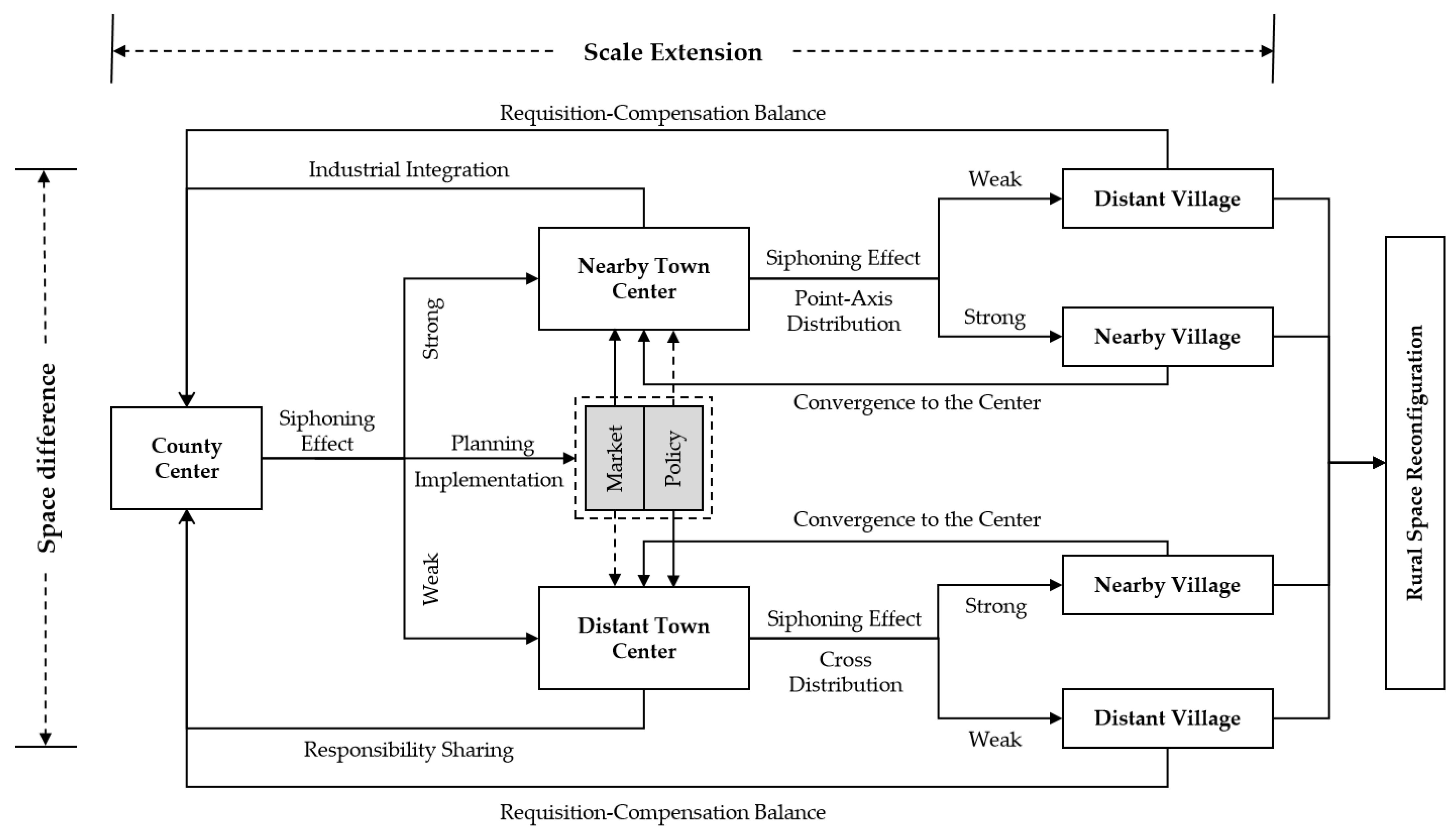
2. Analytical Frameworks and Assumptions

The objective differences in location conditions in different regions determine the pace of urban expansion and further guide strategies for LUR [32,33]. When we analyze the changes in rural land use at the county level as a geographical unit, it is necessary to examine the spatial pattern and location characteristics of rural settlements. In contrast to the trend of urban flattening development, the spatial pattern of the county is a multi-level layered structure centered around various types of towns (including the county center and lower-level town centers) and surrounded by dispersed rural settlements, and the size of settlements shows significant distance attenuation trend [34]. Therefore, the “Core-Periphery” structure can be used to analyze the relationship between various levels of centers in the county.
In the “County-Town-Village” governance system, there are two pairs of “Core-Periphery” relationships due to the scale change within the county area. The first is the relationship between the county center and the surrounding towns, and the second is the relationship between the town center and the surrounding villages. Therefore, the coordinating role of the town can be reflected through the dual identity of the core and periphery. Meanwhile, there is also a distance attenuation trend in the radiating or suction effect of the core area [23], which shows different impact strengths on the LUR of the periphery. Based on this idea, this paper first analyzes the connotation of functional positioning, development planning, and spatial reconstruction of counties, towns, and villages as follows.
(1)
Definition of scale and space. The scale change referred to in this paper is at the county, town, and village levels. The spatial range change refers to the administrative boundaries of counties, towns, and villages (which have almost not changed), as well as the scope of the county center and town center (which changes dynamically). To simplify the research content, the concept of distance is only divided into the relationship between nearby and distant. The nearby towns are divided based on whether the administrative boundaries of towns are adjacent (close) to the county center, while the nearby villages are divided based on whether the administrative boundaries of villages are adjacent to the village at the center of the town (where the town center is located).
(2)
Considering the functional positioning and development planning with the “Core-Periphery” relationship. China’s population mobility trend shows that nearly 30% of the population currently resides in county towns, which have gradually become an important strategic pivot for China’s new urbanization [35]. However, there are still clear shortcomings in infrastructure construction, public service supply, and non-agricultural industry development [36], which inevitably require significant LUR. At this time, under the dual role of administrative contact and transportation association, the impact of county center expansion on nearby and distant towns is different [37,38]. Some lands in nearby towns are integrated with the county center due to its expansion; therefore, their development strategy is mainly focused on undertaking the transfer of county-center industries and strengthening transportation connections with the county center. In contrast, distant towns with relatively small urban land scales undertake more “Requisition-Compensation Balance” tasks [39]; therefore, their residential space remains relatively dispersed. Meanwhile, the town center will construct a more complex transportation network to strengthen its connection with the surrounding villages.
(3)
Spatial reconstruction involving “Macro-Meso-Micro” changes. The process of LUR triggered by the above development strategy will be reflected in the PLES, spatial pattern, and landscape pattern, which correspond to the spatial reconstruction at the “Macro-Meso-Micro” scale of the rural areas. Under the multiple drivers of the economy and policy, the PLES shows a trend of increasing production space and decreasing living and ecological space [40,41]. Focusing on the theme of increasing production space, how to optimize rural living space is the key to integrating rural resources. Therefore, constructing a more complete transportation network system between counties, towns, and villages becomes an intuitive manifestation of spatial pattern evolution [42]. Consequently, at the landscape pattern level, the construction of (residential) land blocks will gradually move closer to traffic routes, leading to reduced fragmentation and increased connectivity, while the importance of ecological lands, such as water and forest lands, will be enhanced [43,44].
Based on the above analysis, this paper makes the following assumptions about rural development trends and their performance in terms of land use:
(1)
H1—The county center will expand significantly within the limits to strengthen its core position; the nearby towns will mainly take over the industrial transfer from the county center and promote industrial integration through LUR; the distant towns will mainly improve public services and enhance their core position through LUR.
(2)
H2—Although the cultivated land gap left by the expansion of the county center needs to be filled by the lower-level towns and villages, the town centers still have some room for development, and the distant towns have more room for future development than the nearby towns.
(3)
H3—There is a general increase in production space. Living and production spaces complement each other, and the changing trend in different areas is related to the optimization of rural residential space.
(4)
H4—Nearby towns strengthen transportation links with the county center, showing a spatial pattern of “Point-Axis” distribution, while the spatial pattern of “cross” distribution is shown in the distant towns. The residential space and ecological barrier will be optimized with the construction of the traffic network.
(5)
H5—The LUR is mainly to reduce fragmentation and promote the concentration of land patches, thus supporting the optimization of rural residential space and industrial development.
Summarizing the above in more concise language in Table 1, the analytical framework and assumptions of this paper are formed. Then, this article attempts to analyze the process of LUR and explore the relationship between core and periphery development from the perspectives of the sources and destinations of land use change, to obtain an initial assessment of rural land use change. Second, the evolution process of the PLES is analyzed from the aspects of production, living, and ecological space, to understand the mechanism of LUR at the macro level. Third, focusing on the three key features that affect spatial patterns, namely, transportation networks, residential patterns, and ecological corridors, the mechanism of rural LUR is understood at the meso level. Finally, a systematic comparison of landscape features, such as land patch area and shape, is conducted at the micro level to understand the mechanism of rural LUR.

3. Materials and Methods
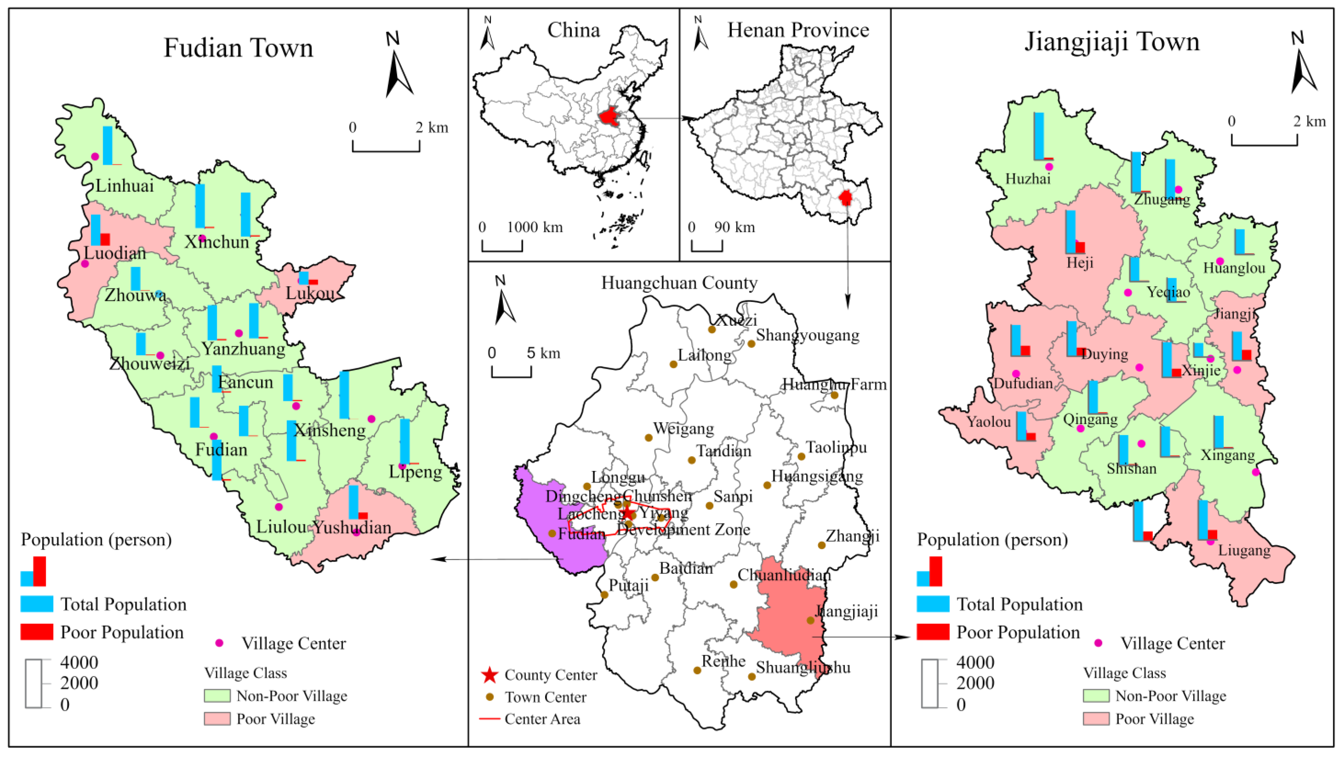
3.1. Study Area

Huangchuan County is located in the southeast of Henan Province and the central part of Xinyang City (Figure 1), with the Dabie Mountains to the south and the Huaihe River to the north. The county has 4 streets, 17 towns, 1 state-owned farm, and 1 industrial agglomeration area, with a total population of 882,400 and a total area of 1666.1 km2. According to the comparative analysis of social and economic development indicators of eight counties in Xinyang City at the end of 2020 (Table 2), Huangchuan County has the highest urbanization rate, the highest proportion of permanent residents to registered residents, and the highest per capita disposable income of urban and rural residents. The total social consumer goods sales are second only to Gushi County, indicating that the outflow of the population in this county is lighter, and the potential and momentum for urban expansion are higher. Moreover, the Beijing-Kowloon Railway runs through Huangchuan County, and its foreign trade is more frequent. Therefore, relative to other areas in Xinyang City, Huangchuan County has more vitality in social development and more flexible and varied land use structure adjustment, making it a representative and typical research area.
To meet the research needs of this article, the county center, Fudian Town, and Jiangjiaji Town were selected as specific areas for empirical research. Among them, Fudian Town is located to the west of the county center, being the closest town to the county center and the only town with an intersection with the planning scope of the county center. Therefore, it can serve as a representative of nearby towns. Jiangjiaji Town is located in the southeast of the county and is the farthest town from the county center. Moreover, its town center is located on the edge of the town, with frequent trade exchanges with the surrounding Gushi County and Shangcheng County. It is a major border trade town in the county and can serve as a representative of distant towns.

3.2. Data Source and Processing

The land use data in this article were obtained by revising the land use plan published by Huangchuan County based on field research. To facilitate the research, some land use types were merged, and 11 different land use types were finally determined (Table 3). If not specified separately, all land area units mentioned in the text are in hectares. It should be emphasized that for areas where old demolition and new construction occurred, to facilitate comparison between different periods, the direction of adjustment for land use types was unified: the land after demolition was converted to cultivated land, and the newly built land was classified as construction land. In addition, this article supplemented some case studies and socio-economic data, mainly sourced from statistical yearbooks and interviews with county and town leaders.

3.3. Methods

3.3.1. Classification and Analysis of “Production-Living-Ecological” Spaces

According to the theoretical viewpoint of “Element-Structure-Function” in system theory, the system structure is the basis for the realization of system functions. Therefore, viewing land use as a system, land use structure is the basis for the realization of land use functions [45]. Thus, the division of PLE spaces is based on the structure of land use types, establishing the connection between land use structure and function, and examining the mechanism of LUR from a macro perspective. According to existing research and the characteristics of the research data [5], this article divides PLES attribution of the 11 land use types (Table 3). As there are situations of functional overlay, the sum of PLE spaces in the subsequent calculation results is not the total area of the region.

3.3.2. Landscape Metrics

The landscape metric is a quantitative indicator that reflects the structural composition and spatial configuration of landscape patterns in a highly condensed form, and establishes a connection between landscape structure and processes or phenomena, to better explain and understand landscape functions [46,47]. Therefore, based on the land use structure and using different land patches as the basic unit, the landscape metrics can be used to characterize the landscape pattern of land use.
According to the research needs of this article and the characteristics of the landscape metrics, six indicators were selected from two levels: landscape level and class level (Table 4). In comparison, these indicators have a simple calculation process, easier data availability, and greater interpretability.
Among them, SDI belongs to the landscape level, and the decrease (increase) in this indicator reflects the decrease (increase) in land use diversity, which indicates that regional development tends to specialize and homogenize. The rest of the indicators are class level. AWMSI and ED describe the shape characteristics, and the reduction in these two indicators reflects that the shape of land patches is more regular, and the reduction in irregular patches is conducive to improving land use efficiency. MPS refers to the average area of land patches and NumP refers to the number of land patches, and the combination of the two can reflect land fragmentation. When the number of land patches decreases and the average area increases, it indicates that the finely fragmented patches have been consolidated and the larger patches can accommodate more development scenarios. PSSD refers to the area difference of land patches, and the larger the difference, the more prominent the characteristics of local agglomeration development. Combining the above indicators, we can judge the effect of rural land improvement and industrial development trends.

4. Results

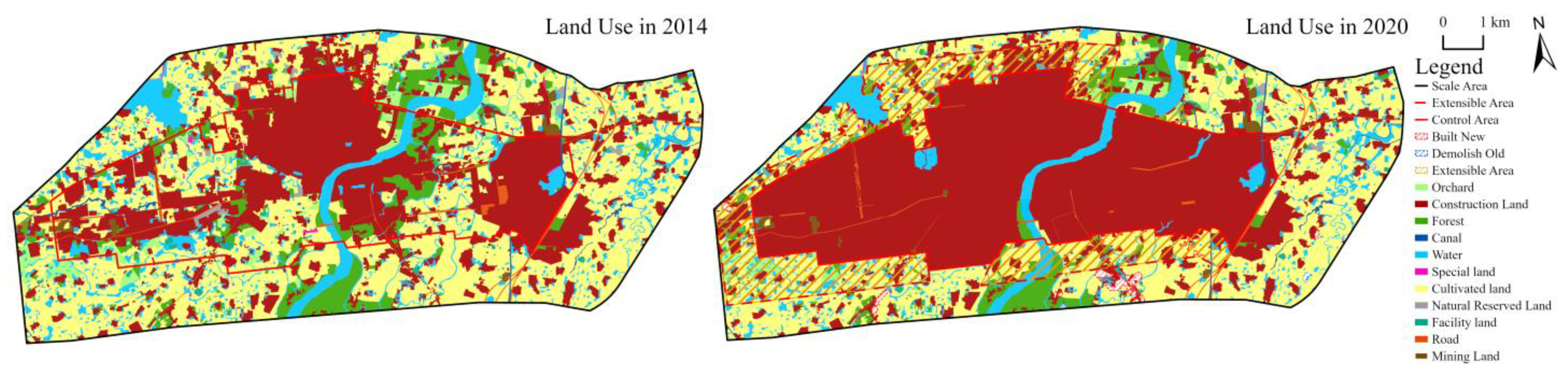
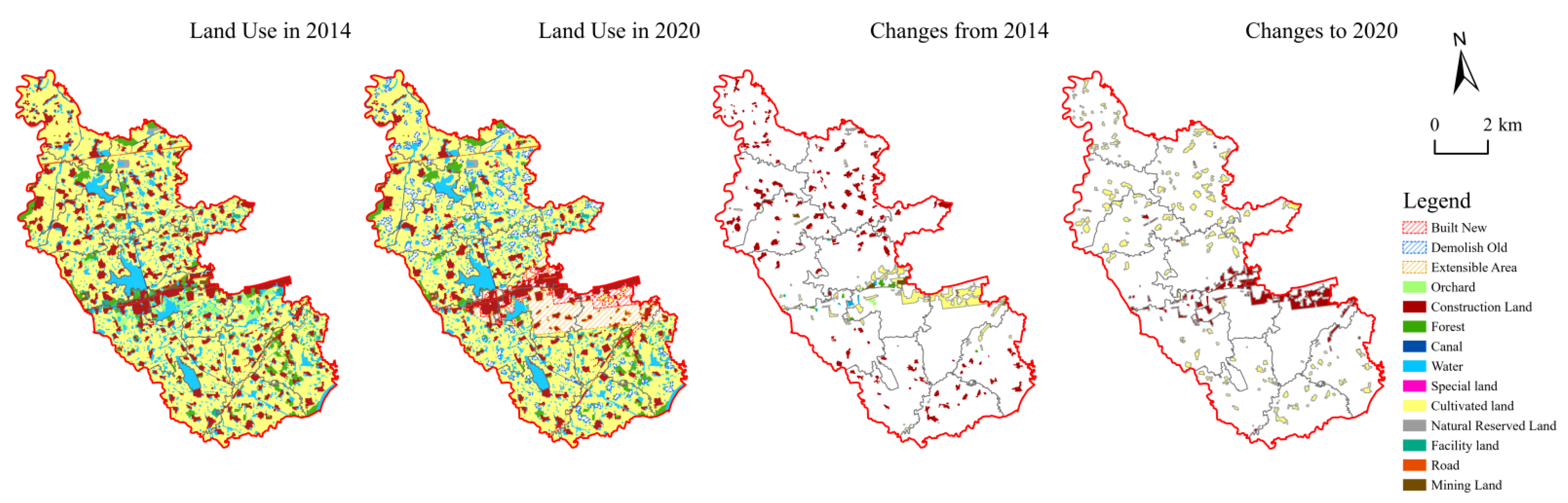
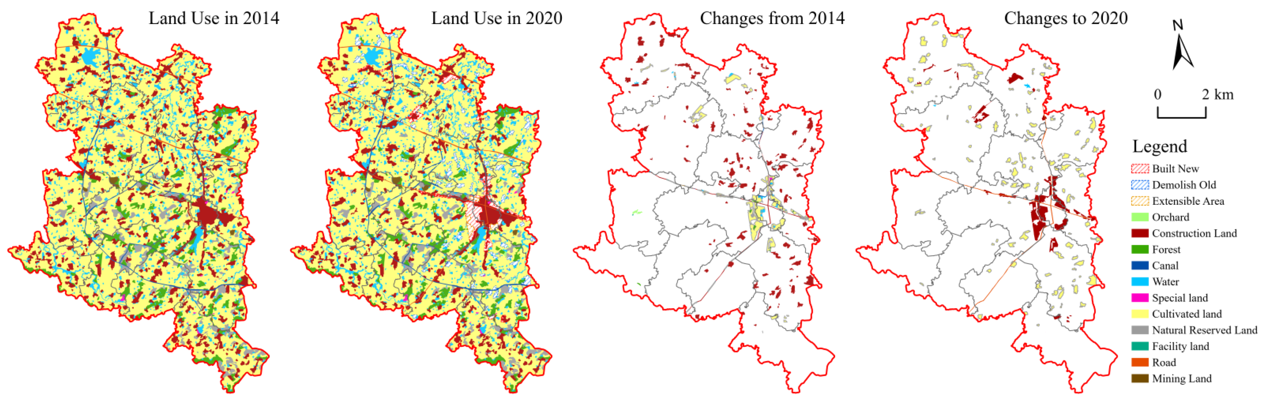
4.1. Process of Rural LUR

4.1.1. Extensive Sources and Intensive Destinations

The types of land use involved in LUR vary across different locations (Table 5). Mining land in the county center remained unchanged, while other types of land were used to supplement construction land, resulting in a 48.1% expansion of construction land. The road and Canal in Fudian Town remained unchanged, indicating relatively sound infrastructure construction, with other types of land use adjustment mainly supplementing cultivated land, especially with a 68.8% decrease in mining land. The LUR in Jiangjiaji Town involved all types of land use, with the largest increase in road area reaching 79.3%.
By examining the land use transfer matrix (Table A1, Table A2 and Table A3), it was found that the LUR mainly focused on the conversion between roads, cultivated land, and construction land. First, the construction of traffic networks reaches every corner of the region, making it the most widely involved area. Second, the increase in the cultivated land area mainly stems from the demolition of construction land, as well as the reclamation of some forest land, facility agriculture, and orchards. Finally, construction land not only occupies cultivated land, but also occupies land other than roads, mining, and facility agriculture for the sake of shape regularity and spatial connectivity. Other types of land use, which are relatively stable in function, show little overall change compared to the above three types.
The above trend of LUR is essentially consistent with the hypothesis of this paper on the functional positioning and development planning for counties, towns, and villages (H1). In the county center, which is in a stage of expansion and urban renewal, all types of land use serve as new construction land. The significant reduction in mining land in nearby towns indicates a shift in their industrial transformation direction, while also reflecting the impact of the expansion of the county center on the surrounding environment. The distant town prepares for the improvement of the town center’s agglomeration through the construction of a traffic network.

4.1.2. Core Area Development Relies on Peripheral Area Support

The large amount and extensive “demolition of old” and “construction of new” (Figure 2, Figure 3 and Figure 4) show that the “Requisition-Compensation Balance” involves the whole county, rather than local adjustment. The expansion of the county center took up 981.76 hectares of cultivated land, which was supplemented by 129.02 hectares in Fudian Town and 85.83 hectares in Jiangjiaji Town, and other towns had to fill the occupied cultivated land.
However, even in this case, there is still space reserved for the lower-level towns to develop. The data show that when extensible space is not considered, the scale of land expansion in the centers of Fudian and Jiangjiaji is only 0.6% and 1.6%, respectively; when extensible space is taken into account, it is 45.0% and 53.8%, respectively (H2). The expansion of Fudian Town is limited, due to invasion stemming from county center expansion. Jiangjiaji Town, which is far from the county center, is granted more space for development.

4.2. Changes in PLE Spaces

4.2.1. Comprehensive Expansion of Production Space

The ranking of the PLE spaces should be production space, ecological space, and living space (Table 6). Since the county center does not undertake agricultural production tasks, its production space is larger than its ecological space, while the production space and ecological space of other towns are not significantly different. As the production space involves more types of land use, the production space in each scale region has increased slightly with a slight reduction in water and natural reserve land, but the growth rate is not significant (H3). The growth rate of production space in different scales decreases with the distance from the core area: the growth rate is higher for nearby towns than for distant towns, and higher for nearby villages than for distant ones.

4.2.2. Complement between Living Space and Ecological Space

The living space and ecological space are complementary; therefore, changes in the two show a reciprocal trend. However, the changing trend varies under different scales and location conditions, and the results of the empirical analysis are essentially consistent with the research hypothesis (H3). The county center sacrifices part of the ecological space and promotes an increase in living space. In contrast, the other towns have decreased overall in the process of gathering living space in the town center and converting it to ecological space. Specifically at the village scale, the nearby villages represent the town centers to a certain extent, similar to the county centers. The clear shrinkage of living space in remote villages may be related to population outflow and the relatively homogeneous production mode (mainly agriculture).

4.3. Changes in Spatial Pattern

4.3.1. Traffic Network Formation

According to the research scale needs of this paper, it does not portray the information on roads below the town level and mainly examines the influence of county and town roads on the regional spatial structure. The evolutionary trend of the town traffic network is essentially consistent with the research hypothesis of this paper. There are roads connecting the north, middle, and south of Fudian Town with the county center, but there is no road running north and south of the town, thus reflecting that Fudian Town is trying to realize the integrated development with the county center through transportation links. Jiangjiaji Town, on the other hand, has built a “cross” traffic network around the town center, especially through the completion of County Road X013. This road greatly reduces the distance between Jiangjiaji Town and the county center and strengthens internal and external connections (H4).

4.3.2. Residential Space Migration

Focusing on the patches where land use types have changed (including demolition of old and construction of new) and showing their spatial distribution before the change (land use types in 2014) and after the change (land use types in 2020) with maps (Figure 3 and Figure 4), the process of rural residential space evolution can be observed more clearly.
The trend of changing residential space in the county center is relatively simple, and the main purpose is to connect the east, middle, and west by filling the space. The central area of Fudian Town is a typical “one-line” layout, while the rest of the residential space is scattered. Since its central area is more closely connected to the county center and has convenient transportation, the subsequent demolition plan is mainly in the more remote northern and southern areas (Figure 3), which increases the width of the “one-line” layout. In contrast, Jiangjiaji Town is a typical “cross” layout, in which the “cross” continues to “fatten up” in a “circle”. In the process of the “cross” to “circle” continuous “fattening”, the main absorption is the area around the town center (Figure 4), i.e., the main demolition area, while the demolition of remote areas is relatively small.
In summary, the traffic network is still a key factor affecting the spatial pattern (H4). Although remote towns rely on the “cross” traffic network to enhance local agglomeration, their connectivity with the county center still indicates the importance of county-town linkages for town development.

4.3.3. Ecological Corridor Construction

While the LUR has contributed to the expansion of the town center area, it has also brought many beneficial “side effects”, such as promoting the formation of ecological corridors. This is most evident in Jiangjiaji Town.
The county center has sacrificed some ecological space to achieve internal connectivity and coverage, and no ecological corridor of a certain scale has emerged. Although the total area of Fudian Town is smaller than that of Jiangjiaji Town, its water area is larger. Several larger reservoirs are arranged along the north-south direction, which does not coincide with the town’s development along the east-west axis (Figure 3). As a result, there are clear ecological corridors only on both sides of the central axis. The construction land vacated in Jiangjiaji Town is mostly distributed around waters and woodlands (Figure 4), promoting a contiguous distribution of ecological space (H4). As can be seen from the 2020 land use map, Jiangjiaji Town has formed a multi-level circle structure of “town center-ecological corridor-village settlement-artificial water channel-village settlement”, with ecological space as a buffer between village settlements. This arrangement not only gives full play to the environmental protection of the ecological corridor, but also creates conditions for expanding rural recreational areas and further developing the rural tourism industry.

4.4. Changes in Landscape Pattern

4.4.1. Larger and Simpler Patches

Overall, SDI, AWMSI, ED, and NumP showed a decreasing trend, while MPS showed an increasing trend and PSSD showed significant differences (Table 7). This indicates that the land use structure in the study area has become less diverse, with more regular-shaped land patches; the degree of boundary segmentation has decreased, fragmentation has decreased, and connectivity has improved; the average area of a single patch has increased, but the total number of patches has decreased, indicating a significant land integration effect (H5).
The main reason why PSSDs show significant differences is that different regions engage in different efforts to demolish the old and build the new. The county center is the most intense, basically adjusting all the land within the planning area to be used for construction. Jiangjiaji Town demolished 111 plots and built 36 new plots, while Fudian Town demolished 135 plots and built 69 new plots, resulting in a significant reduction in the number of land plots in Fudian Town and an increase in the difference in the relative size of different plots. This shows that, on the one hand, residential space tends to be concentrated, and on the other hand, agricultural production is transforming to scale and intensification.

4.4.2. Patch Changes Conformed to Industrial Development Trends

Different development strategies for different regions are reflected in the changes in land use types (Table A4, Table A5 and Table A6). In the county center, the number of cultivated land patches has sharply decreased, while mining and road patches have increased. On the one hand, this increases employment opportunities, and on the other hand, it prepares for the expansion of construction land. Especially in facility agriculture, not only has the number of patches increased significantly, but the average patch size has also increased, in response to the food consumption demand brought about by population growth. In Fudian Town, the number of patches for all land use types has decreased, and the average patch size has mostly decreased. On the one hand, this reflects the influence of the expansion of the county center on the entire region and the greater intensity of land consolidation; on the other hand, it reflects the gradual shrinkage of agricultural production in the region.
In Jiangjiaji Town, the cultivation and canal shaping intensity is the highest, while the complexity of roads has increased due to the construction of a cross-traffic network. The natural resource conditions of Jiangjiaji Town have significantly promoted its advantages in fishing, forestry, and animal husbandry, and the average patch size of water and forest areas has increased; the development of the fruit industry is significantly insufficient, with only one typical area left; the mining industry has remained the same in quantity, but the average area has decreased due to environmental protection and energy conservation along with emission reduction restrictions.
Combining the changes in the two levels of landscape patterns, we can see that in the process of LUR, the degree of fragmentation has been reduced through land consolidation and landscape connectivity has been improved. LUR has also further supported regional industrial development and met basic social needs, reflecting its importance in solving social development problems (H5).

5. Discussion

5.1. Market Regulation or Policy Regulation

From the processes of LUR in Fudian Town and Jiangjiaji Town, we can find that they are not only the representatives of nearby and distant towns, but also rural land use market regulation and policy regulation.
The government can guide the LUR by establishing a more flexible land transfer market, and the key is whether the local government can create conditions for land marketization [48]. The process of LUR in Huangchuan County found that first, in planning, the Fudian Town next to the county center was invaded by expanding the central area of the county. Then, in practice, the largest poultry group in the county, and the first listed company in China’s duck industry, Huaying Corporation, built its core factory in Fudian Town through industrial transfer. At this point, the potential for higher land prices and increased convenience of life motivated the town to restructure its land use. This suggests that market-based rural construction land transfer is an important complement to administrative land allocation [49], contributing to the development of industrial clusters and significantly increasing the value of industrial land.
The government can also guide the LUR by formulating overall land use planning, land use policies, land subsidy policies, and other means. Only 35.73% of the patches where land use changed in Jiangjiaji Town are located in poor villages. The reason why the land use in the above-mentioned areas has not changed significantly is mainly due to the fact that they have just received policy assistance. In contrast to Fudian Town, Jiangjiaji Town has more poor population and a wider distribution (Figure 1). From 2014 to 2020, it coincided with the entire period of China’s poverty alleviation campaign. On the one hand, the transmission mechanism of poverty alleviation policies is aimed at poor households, namely, poverty alleviation policies should reflect the poverty reduction results of farmers. Therefore, the implementation of poverty alleviation policies, such as industry, employment, education, finance, and housing reconstruction, cannot be reflected at the scale of land patches. On the other hand, the targeted poverty alleviation strategy provides comprehensive support to poor villages, even leading to the phenomenon that the infrastructure construction level of some poor villages exceeds that of non-poor villages [50,51,52]. This is why the LUR did not significantly deploy to the newly reformed poor (distant) villages but focused on the town center. This indicates that for distant towns, especially areas where poor populations are concentrated, due to their relatively backward development level, enhancing the agglomeration of the town center is the current top priority, and at this time, policy regulation is significantly stronger than market regulation.
To sum up, we return to the “Scale-Space” interaction perspective emphasized in this paper to reveal the mechanism of LUR for rural sustainable development (Figure 5). Rural areas should adhere to the principle of integrated development, take the development of centers at all levels (county centers and town centers) as the driving force, and reasonably arrange the roles and responsibilities of towns and villages in different locations. Through the LUR, on the basis of satisfying the requisition-compensation balance, the towns are used as the hub to promote industrial integration and duty reshaping upward and spatial reconfiguration and pattern optimization downward. Ultimately, the spatial reconfiguration leads to the flow of factors within the county, thus strengthening the interactive relationship between the county, town, and village and promoting rural sustainable development.

5.2. The Importance of Small Towns to Daily Lives

Nearby and distant towns, divided according to distance, determine different development directions due to the difference in kinship with the county center. Moreover, since the LUR occurs mainly in construction land (the majority of which is residential space), rural LUR has a profound impact on the daily lives of residents.
The status and role of small towns in sustainable rural development have been reiterated in previous papers; therefore, this paper is more concerned with the development of towns that are far away from the county center, such as Jiangjiaji Town. Field research found that since Jiangjiaji Town is very far away from the county center, local residents mostly do not rely on the county center for their daily lives. At present, the town has a relatively good infrastructure, with three supermarkets and a rural assembly every 2 days. Catering, clothing, and other retail businesses are well-developed and fully meet daily consumption needs. All village offices have completed standardized construction, and recreational facilities and fitness equipment are available. The only thing lacking is an independent and spacious recreational square or park. In terms of rural governance, the town government has eight offices and three centers, and the departments that face the most people are the Administrative Approval Center (for pension insurance business), the Public Service Center (for low-income insurance), the Peace Building Office (for the letter and visit business), and the Village Construction Office (for agricultural development), and all kinds of demands of rural people can be effectively solved through the town departments.
In summary, the geographic isolation and low population density in rural environments make it very difficult for rural residents to provide quality and accessible local services. This general problem, however, does not negate the fact that small towns still play an important role in local areas. This is mainly due to two things. First, the ease of transportation. The town center is supported by more efficient intra-town transportation and improved mobility equity issues than the county center [53]. Second, the supply of services is adequate. Both in terms of commercial layout and social security, small towns can give adequate public service supply to local residents [13,20]. Although there are currently shortcomings in some higher quality services (e.g., larger independent parks), enough space has been reserved for town center expansion, which can be continuously made up in the future through LUR. Therefore, the role of small towns should be positioned not only by examining their conditions, but also by understanding their locational characteristics in the county in order that their sub-center role can be fully exploited.

6. Conclusions

This article focuses on the issue of rural LUR and builds a systematic analysis framework based on the perspective of “Scale-Space” interaction. From the three aspects of functional positioning, planning guidance, and spatial reconstruction, it deeply analyzes the mechanisms of LUR in different locations and their interactions. The main conclusions are as follows.
(1)
The evolutionary characteristics of land use structure, consistent with the assumptions established in the analytical framework, reflect the strong explanatory power of the analytical framework and emphasize that locational conditions are the key factors influencing rural LUR.
(2)
Rural LUR is a comprehensive planning mode under the multiple effects of market and policy, and its processes and mechanisms can be fully revealed only through cross-scale analysis. This also requires us to study rural land use from the perspective of “Scale-Space” interaction.
(3)
The county, town, and village will eventually achieve comprehensive and sustainable rural development through multiple rounds of balance. Among them, small towns, especially those far from the county center, can enhance their cohesion, support the development of the surrounding villages, and coordinate the relationship between the county, town, and village by constantly switching between the dual identity of core and periphery. This reinforces the understanding that rural land use problems can be effectively solved through small-town development.
According to the current work progress, this article has only conducted a systematic analysis of the county center and two typical villages in Huangchuan County. However, the results have already verified the research hypothesis proposed in this article. If a cross-scale study of the entire county can be conducted, it is expected to refine the analysis framework and research hypotheses. It will also be able to further summarize more precise mechanisms of LUR from the quantitative analysis level, providing more powerful theoretical support for rural sustainable development. In addition, it is possible to further explore the scale extension and delve deeper into the farm household level to build a complete “County-Town-Village-Household” system. Reflecting the impact of rural spatial reconfiguration on rural transformation development from the perspective of farmers is conducive to deepening our understanding of rural social relations, social networks, and social governance.

Author Contributions

C.Y., J.G. and Q.Z. conceptualized the study. C.Y., Z.H., X.Z. and H.G. finished the data analysis. C.Y. prepared the first draft of the manuscript and played a major role in structuring arguments and smoothing out the text. All authors have read and agreed to the published version of the manuscript.

Funding

This research was funded by the National Natural Science Foundation of China (U1904125); the Foundation of Humanity and Social Sciences of the Ministry of Education in China (18YJA840003, 20YJCZH244); Scientific and Technological Innovation Talents in Colleges and Universities of Henan Province in China (2021-CX-027); Student Research Foundation of Xinyang Normal University (2022-DXS-118).

Institutional Review Board Statement

Not applicable.

Informed Consent Statement

Not applicable.

Data Availability Statement

The data of rural land use in Huangchuan County were processed according to the published land use plan (public notice by the county government website) and field survey. To facilitate the research, the land use types have been modified, merged, and other operations, but are consistent with the actual situation. Other statistics are from China Statistical Yearbook (open access) or provided by local governments (interview access).

Acknowledgments

The authors gratefully acknowledge all funding and Nanhu Scholars Program for Young Scholars of XYNU for support of this research. We would like to express our thanks to the editor and all anonymous reviewers for their insightful comments and suggestions.

Conflicts of Interest

The authors declare no potential conflicts of interest with respect to the research, authorship, and/or publication of this article.

Appendix A

Table A1. Land use transfer matrix in county center.
ClassMiningRoadCultivatedConstructionForestFacilityCanalWaterSpecialOrchardNatural ReservedTotal (2014)
mining62.98 62.98
road 111.17 20.90 132.07
cultivated 0.393142.86964.9611.77 17.50 4137.49
construction 0.667.513360.20 3368.38
forest 0.154.33239.65432.71 0.16 677.00
facility 0.9922.09 32.39 0.31 55.77
canal 14.56 38.82 53.37
water 0.03234.930.87 951.30 1187.13
special 8.73 11.45 20.18
orchard 103.700.66 5.90 163.33 273.59
natural reserved 18.21 27.1945.40
total (2020)62.98112.383155.734987.93446.0032.3938.82975.1611.45163.3327.1910,013.36
Table A2. Land use transfer matrix in Fudian Town.
ClassMiningRoadCultivatedConstructionForestFacilityCanalWaterSpecialOrchardNatural ReservedTotal (2014)
mining8.58 18.91 27.49
road 46.28 46.28
cultivated 5056.03220.04 5276.07
construction 335.88807.48 1143.36
forest 0.8211.82276.66 289.30
facility 1.44 13.88 15.32
canal 51.34 51.34
water 8.97 987.73 996.71
special
orchard 4.290.72 9.42 14.43
natural reserved 8.08 12.0320.11
total (2020)8.5846.285405.091069.39276.6613.8851.34987.73 9.4212.037880.40
Table A3. Land use transfer matrix in Jiangjiaji Town.
ClassMiningRoadCultivatedConstructionForestFacilityCanalWaterSpecialOrchardNatural ReservedTotal (2014)
mining22.710.43 23.14
road 51.68 51.68
cultivated 9.975972.26172.70 2.85 6157.78
construction 26.80266.96947.77 1241.53
forest 0.230.813.31482.87 487.22
facility 0.050.22 2.69 2.96
canal 2.75 1.26 98.78 102.79
water 11.27 855.44 866.71
special 0.14 1.13 11.57 12.85
orchard 0.103.360.36 1.92 5.74
natural reserved 0.50 5.09 373.37378.97
total (2020)22.7192.656243.611142.90482.872.6998.78858.2911.571.92373.379331.37

Appendix B

Table A4. Changes in landscape metrics with the class level in the county center.
ClassAWMSIEDMPSNumPPSSD
2014202020142020201420202014202020142020
Mining1.455.521.5759.743.1514.61202162.9948.15
Road11.712.7211.7943.966.6010.102049411.84123.49
Cultivated6.081.6075.900.9415.270.322713656.830.33
Construction3.3511.2150.7713.216.393.635273149.857.95
Forest1.981.8417.4411.723.182.972131507.926.94
Facility1.272.472.5038.980.711.35797250.956.64
Canal3.981.265.131.671.140.5747571.920.64
Water2.823.7050.693.991.370.95857416.611.52
Special1.531.551.460.910.361.8156150.481.82
Orchard2.102.127.584.664.643.8059435.325.47
Natural Reserved1.761.411.371.712.842.4216262.882.62
Table A5. Changes in landscape metrics with the class level in Fudian Town.
ClassAWMSIEDMPSNumPPSSD
2014202020142020201420202014202020142020
Mining1.651.830.940.303.254.29822.612.53
Road9.159.155.195.199.269.26557.327.32
Cultivated13.0911.4292.9883.5974.70105.986651283.81354.78
Construction1.772.2239.5628.103.245.243542044.6215.55
Forest1.911.8213.7711.162.232.161501283.833.82
Facility1.341.532.340.731.461.1638121.801.18
Canal5.725.895.304.914.675.1312104.004.10
Water1.941.8963.2954.111.071.0710549223.974.17
Special----------
Orchard2.981.854.620.409.983.141439.632.30
Natural Reserved1.921.740.740.383.563.01644.164.40
Table A6. Changes in landscape metrics with the class level in Jiangjiaji Town.
ClassAWMSIEDMPSNumPPSSD
2014202020142020201420202014202020142020
Mining1.481.410.510.545.794.54453.162.77
Road7.2814.723.076.8817.2330.88339.6628.61
Cultivated13.637.4396.1889.54116.1894.605366377.89183.14
Construction1.932.0837.1530.723.204.103882797.119.93
Forest2.192.1914.8614.584.274.471141085.705.80
Facility1.291.310.280.260.230.2213120.160.17
Canal10.826.987.216.886.855.81151716.618.41
Water2.242.2547.4746.920.790.79109610822.282.32
Special1.351.350.680.620.710.6818170.850.87
Orchard1.921.410.260.071.911.92311.180.00
Natural Reserved2.012.0212.0811.873.994.0195933.963.99

References

  1. Long, H. Land Consolidation: An Indispensable Way of Spatial Restructuring in Rural China. J. Geogr. Sci. 2014, 24, 211–225. [Google Scholar] [CrossRef]
  2. Van Huylenbroeck, G.; Durand, G. Multifunctional Agriculture: A New Paradigm for European Agriculture and Rural Development; Ashgate Publishing: Farnham, UK, 2003; ISBN 978-0-7546-3576-5. [Google Scholar]
  3. Qu, Y.; Jiang, G.; Zhao, Q.; Ma, W.; Zhang, R.; Yang, Y. Geographic Identification, Spatial Differentiation, and Formation Mechanism of Multifunction of Rural Settlements: A Case Study of 804 Typical Villages in Shandong Province, China. J. Clean. Prod. 2017, 166, 1202–1215. [Google Scholar] [CrossRef]
  4. Ma, W.; Jiang, G.; Li, W.; Zhou, T.; Zhang, R. Multifunctionality Assessment of the Land Use System in Rural Residential Areas: Confronting Land Use Supply with Rural Sustainability Demand. J. Environ. Manag. 2019, 231, 73–85. [Google Scholar] [CrossRef] [PubMed]
  5. Liu, J.; Liu, Y.; Li, Y. Classification Evaluation and Spatial-Temporal Analysis of “Production-Living-Ecological” Spaces in China. Acta Geogr. Sin. 2017, 72, 1290–1304. (In Chinese) [Google Scholar]
  6. Gao, J.; Song, G.; Sun, X. Does Labor Migration Affect Rural Land Transfer? Evidence from China. Land Use Policy 2020, 99, 105096. [Google Scholar] [CrossRef]
  7. Powe, N.A.; Hart, T.; Bek, D. Market Town Centres in England: Meeting the Challenge of Maintaining Their Contemporary Relevance. Plan. Pract. Res. 2009, 24, 301–319. [Google Scholar] [CrossRef]
  8. Zhou, Y.; Li, X.; Liu, Y. Cultivated Land Protection and Rational Use in China. Land Use Policy 2021, 106, 105454. [Google Scholar] [CrossRef]
  9. Qu, Y.; Zhao, W.; Zhao, L.; Zheng, Y.; Xu, Z.; Jiang, H. Research on Hollow Village Governance Based on Action Network: Mode, Mechanism and Countermeasures-Comparison of Different Patterns in Plain Agricultural Areas of China. Land 2022, 11, 792. [Google Scholar] [CrossRef]
  10. Guo, S.; Chen, Q.; He, Y.; Xu, D. Spatial-Temporal Features and Correlation Studies of County Rural Hollowing in Sichuan. Int. J. Environ. Res. Public Health 2022, 19, 9075. [Google Scholar] [CrossRef]
  11. Xu, B.; Niu, Y.; Zhang, Y.; Chen, Z.; Zhang, L. China’s Agricultural Non-Point Source Pollution and Green Growth: Interaction and Spatial Spillover. Environ. Sci. Pollut. Res. 2022, 29, 60278–60288. [Google Scholar] [CrossRef]
  12. Xu, L.; Jiang, J.; Lu, M.; Du, J. Spatial-Temporal Evolution Characteristics of Agricultural Intensive Management and Its Influence on Agricultural Non-Point Source Pollution in China. Sustainability 2023, 15, 371. [Google Scholar] [CrossRef]
  13. Zhu, J. The Role and Function of Towns in the Urban-rural Integrated Development: Case Studies. Urban Plan. Forum 2015, 32–38. [Google Scholar] [CrossRef]
  14. Wirth, P.; Elis, V.; Müller, B.; Yamamoto, K. Peripheralisation of Small Towns in Germany and Japan—Dealing with Economic Decline and Population Loss. J. Rural Stud. 2016, 47, 62–75. [Google Scholar] [CrossRef]
  15. Van Leeuwen, E.S.; Rietveld, P. Spatial Consumer Behaviour in Small and Medium-Sized Towns. Reg. Stud. 2011, 45, 1107–1119. [Google Scholar] [CrossRef]
  16. Powe, N.A. Non-Amenity Business Growth and Small Town Revival. J. Rural Stud. 2018, 62, 125–133. [Google Scholar] [CrossRef]
  17. He, S.; Zhang, Y. Reconceptualising the Rural through Planetary Thinking: A Field Experiment of Sustainable Approaches to Rural Revitalisation in China. J. Rural Stud. 2022, 96, 42–52. [Google Scholar] [CrossRef]
  18. Comprehensively Promoting Rural Revitalization and Accelerating Agricultural and Rural Modernization; Central Committee of the Communist Party of China: Beijing, China, 2021.
  19. Yin, X.; Wang, J.; Li, Y.; Feng, Z.; Wang, Q. Are Small Towns Really Inefficient? A Data Envelopment Analysis of Sampled Towns in Jiangsu Province, China. Land Use Policy 2021, 109, 105590. [Google Scholar] [CrossRef]
  20. Yu, Z.; Yuan, D.; Zhao, P.; Lyu, D.; Zhao, Z. The Role of Small Towns in Rural Villagers’ Use of Public Services in China: Evidence from a National-Level Survey. J. Rural Stud. 2023, 100, 103011. [Google Scholar] [CrossRef]
  21. Gong, X.; Zhang, X.; Tao, J.; Li, H.; Zhang, Y. An Evaluation of the Development Performance of Small County Towns and Its Influencing Factors: A Case Study of Small Towns in Jiangyin City in the Yangtze River Delta, China. Land 2022, 11, 1059. [Google Scholar] [CrossRef]
  22. Long, Y.; Wu, K. Shrinking Cities in a Rapidly Urbanizing China. Environ. Plan. A 2016, 48, 220–222. [Google Scholar] [CrossRef]
  23. Tong, Y.; Liu, W.; Li, C.; Zhang, J.; Ma, Z. Small Towns Shrinkage in the Jilin Province: A Comparison between China and Developed Countries. PLoS ONE 2020, 15, e0231159. [Google Scholar] [CrossRef] [PubMed]
  24. Zhao, P.; Lyu, D. Characteristics of land use structure in small towns of China: Empirical evidences from 121 townships. Acta Geogr. Sin. 2019, 74, 1011–1024. (In Chinese) [Google Scholar]
  25. Yin, X.; Li, Y.; Yuan, T.; Wang, Q. Quantitative measurement of economic development and land use intensity and their correlation characteristics in 109 sampled towns of Jiangsu province. J. Nat. Resour. 2020, 35, 614–625. (In Chinese) [Google Scholar]
  26. Cui, X.; Ma, L.; Tao, T.; Zhang, W. Do the Supply of and Demand for Rural Public Service Facilities Match? Assessment Based on the Perspective of Rural Residents. Sustain. Cities Soc. 2022, 82, 103905. [Google Scholar] [CrossRef]
  27. Pan, M.; Huang, Y.; Qin, Y.; Li, X.; Lang, W. Problems and Strategies of Allocating Public Service Resources in Rural Areas in the Context of County Urbanization. Int. J. Environ. Res. Public Health 2022, 19, 14596. [Google Scholar] [CrossRef] [PubMed]
  28. Ye, S.; Ren, S.; Song, C.; Cheng, C.; Shen, S.; Yang, J.; Zhu, D. Spatial Patterns of County-Level Arable Land Productive-Capacity and Its Coordination with Land-Use Intensity in Mainland China. Agric. Ecosyst. Environ. 2022, 326, 107757. [Google Scholar] [CrossRef]
  29. Tong, Y.; Liu, W.; Li, C.; Zhang, J.; Ma, Z. Understanding Patterns and Multilevel Influencing Factors of Small Town Shrinkage in Northeast China. Sustain. Cities Soc. 2021, 68, 102811. [Google Scholar] [CrossRef]
  30. Du, W.; Wang, Y.; Qian, D.; Lyu, X. Process and Eco-Environment Impact of Land Use Function Transition under the Perspective of “Production-Living-Ecological” Spaces-Case of Haikou City, China. Int. J. Environ. Res. Public Health 2022, 19, 16902. [Google Scholar] [CrossRef]
  31. Li, X.; Chen, H.; Zhu, Z. Exploring the Relationship between Life Quality and the Perceptions of Living-Environment Crises. BMC Public Health 2021, 21, 774. [Google Scholar] [CrossRef]
  32. Wu, R.; Wang, J.; Zhang, D.; Wang, S. Identifying Different Types of Urban Land Use Dynamics Using Point-of-Interest (POI) and Random Forest Algorithm: The Case of Huizhou, China. Cities 2021, 114, 103202. [Google Scholar] [CrossRef]
  33. Wang, X.; Yao, X.; Shao, H.; Bai, T.; Xu, Y.; Tian, G.; Fekete, A.; Kollányi, L. Land Use Quality Assessment and Exploration of the Driving Forces Based on Location: A Case Study in Luohe City, China. Land 2023, 12, 257. [Google Scholar] [CrossRef]
  34. Zhang, R.; Zhang, X. Distribution Characteristics and Influencing Factors of Rural Settlements in Metropolitan Fringe Area: A Case Study of Nanjing, China. Land 2022, 11, 1989. [Google Scholar] [CrossRef]
  35. Zhu, H.; Wang, W. County-based Urbanization from the Economic Perspective: Internal Logic, Difficulties and Feasible Routes. J. Xinjiang Norm. Univ. Philos. Soc. Sci. 2022, 43, 57–66+2. (In Chinese) [Google Scholar] [CrossRef]
  36. Yu, J.; Zhao, W. County urbanization: Carrier functions, gradient patterns and construction paths. Urban Probl. 2022, 11, 14–23. (In Chinese) [Google Scholar] [CrossRef]
  37. Wei, W.; Zhang, X.; Liu, C.; Zhou, J.; Xie, B.; Li, C. Spatial Interaction of Urban-Rural System and Influence Pattern in the Arid Inland River Basin—A Case Study in Shiyang River Basin in Northwest China. Pol. J. Environ. Stud. 2021, 30, 3307–3316. [Google Scholar] [CrossRef]
  38. Mozaffaree Pour, N.; Oja, T. Prediction Power of Logistic Regression (LR) and Multi-Layer Perceptron (MLP) Models in Exploring Driving Forces of Urban Expansion to Be Sustainable in Estonia. Sustainability 2022, 14, 160. [Google Scholar] [CrossRef]
  39. Li, C.; Jin, X.; Zhi, J.; Luo, Y.; Li, M.; Liu, W. Evaluating Whether Farmland Consolidation Is a Feasible Way to Achieve a Balance of Potential Crop Production in Southeastern Coastal China. Land 2022, 11, 1918. [Google Scholar] [CrossRef]
  40. Yu, H.; Du, S.; Zhang, J.; Chen, J. Spatial Evolution and Multi-Scenario Simulation of Rural “Production–Ecological–Living” Space: A Case Study for Beijing, China. Sustainability 2023, 15, 1844. [Google Scholar] [CrossRef]
  41. Duan, Y.; Wang, H.; Huang, A.; Xu, Y.; Lu, L.; Ji, Z. Identification and Spatial-Temporal Evolution of Rural “Production-Living-Ecological” Space from the Perspective of Villagers’ Behavior—A Case Study of Ertai Town, Zhangjiakou City. Land Use Policy 2021, 106, 105457. [Google Scholar] [CrossRef]
  42. Chen, Z.; Liu, Y.; Feng, W.; Li, Y.; Li, L. Study on Spatial Tropism Distribution of Rural Settlements in the Loess Hilly and Gully Region Based on Natural Factors and Traffic Accessibility. J. Rural Stud. 2022, 93, 441–448. [Google Scholar] [CrossRef]
  43. Li, M.; Xie, Y.; Li, Y. Transition of Rural Landscape Patterns in Southwest China’s Mountainous Area: A Case Study Based on the Three Gorges Reservoir Area. Env. Earth Sci. 2021, 80, 742. [Google Scholar] [CrossRef]
  44. Gong, Y.; You, G.; Chen, T.; Wang, L.; Hu, Y. Rural Landscape Change: The Driving Forces of Land Use Transformation from 1980 to 2020 in Southern Henan, China. Sustainability 2023, 15, 2565. [Google Scholar] [CrossRef]
  45. Lin, G.; Jiang, D.; Fu, J.; Zhao, Y. A Review on the Overall Optimization of Production–Living–Ecological Space: Theoretical Basis and Conceptual Framework. Land 2022, 11, 345. [Google Scholar] [CrossRef]
  46. Mcgarigal, K.; Marks, B.J. FRAGSTATS—Spatial Pattern Analysis Program for Quantifying Landscape Structure; U.S. Department of Agriculture, Forest Service, Pacific Northwest Research Station: Portland, OR, USA, 1995; Volume 351, 122p.
  47. Shao, S.; Yu, M.; Huang, Y.; Wang, Y.; Tian, J.; Ren, C. Towards a Core Set of Landscape Metrics of Urban Land Use in Wuhan, China. ISPRS Int. J. Geo-Inf. 2022, 11, 281. [Google Scholar] [CrossRef]
  48. Kan, K. Creating Land Markets for Rural Revitalization: Land Transfer, Property Rights and Gentrification in China. J. Rural Stud. 2021, 81, 68–77. [Google Scholar] [CrossRef]
  49. Jiao, M.; Xu, H. Does Rural Construction Land Marketization Inhibit State-Owned Industrial Land Transactions? Evidence from Huzhou City, China. Land 2022, 11, 1587. [Google Scholar] [CrossRef]
  50. Yu, C.; Gao, J.; Han, Y.; Wang, Y.; Sun, J. Eliminating Deprivation and Breaking through Dependence: A Mechanism to Help Poor Households Achieve Sustainable Livelihoods by Targeted Poverty Alleviation Strategy. Growth Chang. 2022, 53, 1436–1456. [Google Scholar] [CrossRef]
  51. Yu, C.; Gao, J.; Zhang, X.; Sun, J. Policy Connection Path of Pairing Assistance in the County During the Post-poverty Era: A Case Study of Huangchuan County of Henan Province. Econ. Geogr. 2022, 42, 19–26. (In Chinese) [Google Scholar] [CrossRef]
  52. Yu, C.; Sun, J.; Gao, J. Organic Connection between Poverty Alleviation and Rural Revitalization from the Perspective of Government Public Information—A Big Data Analysis based on 53 Poor Counties in Henan Province. J. Xinjiang Norm. Univ. Philos. Soc. Sci. 2021, 41, 38–44. (In Chinese) [Google Scholar]
  53. Zhao, P.; Yu, Z. Investigating Mobility in Rural Areas of China: Features, Equity, and Factors. Transp. Policy 2020, 94, 66–77. [Google Scholar] [CrossRef]
Figure 1. Location and administrative division of study area.
Sustainability 15 12600 g001
Figure 2. Changes in land use of the county center from 2014 to 2020.
Sustainability 15 12600 g002
Figure 3. Changes in land use of nearby town (Fudian Town) from 2014 to 2020.
Sustainability 15 12600 g003
Figure 4. Changes in land use of distant town (Jiangjiaji Town) from 2014 to 2020.
Sustainability 15 12600 g004
Figure 5. Mechanism of LUR for rural sustainable development.
Sustainability 15 12600 g005
Table 1. Analytical framework and assumptions.
ScaleFunctionPlanSpace
Core-PeripheryGuideSchemePLESSpatial PatternLandscape Pattern
CountyStrong Core in A1 and R1Strengthen Core PositionExpand the Scope and Clarify the BoundariesP > E >> L
P↑ L↑ E↓
Contiguous Distribution
  • Decreased Diversity
  • More Patches with Larger Areas, More Regular Shape
  • Larger Difference in Patch Area
TownNearbyWeak Core in A1, A2, and R2
Periphery in R1
Undertake Function TransferOutward Roads Construction for Industrial IntegrationP ≈ E >> L
P↑ L↓ E↑
Point-Axis Distribution
  • Decreased Diversity
  • Fewer Patches with Larger Areas, More Regular Shape
  • Larger Difference in Patch Area
DistantPeriphery in A1 and R1
Strong Core in A2 and R2
Complete Core FunctionsInternal Roads Construction for Population AggregationP ≈ E >> L
P↑ L↓ E↑
Cross Distribution
  • Decreased Diversity
  • Fewer Patches with Larger Areas, More Regular Shape
  • Smaller Difference in Patch Area
VillageNearbyWeak Core in A2
Periphery in R2
Support Core AdjustmentLand Conservation and Intensive UseP ≈ E >> L
P↑ L↑ E↓
Dispersed Distribution
  • Decreased Diversity (in Nearby Towns)
  • Increased Diversity (in Distant Towns)
  • Fewer Patches with Larger Areas, More Regular Shape
  • Larger Difference in Patch Area (in Nearby Towns)
  • Smaller Difference in Patch Area (in Distant Towns)
DistantPeriphery in A2
Periphery in R2
Support Agricultural DevelopmentCultivated Land ProtectionP ≈ E >> L
P↑ L↓ E↑
Dispersed Distribution
  • Decreased Diversity
  • Fewer Patches with Larger Areas, More Regular Shape
  • Larger Difference in Patch Area (in Nearby Towns)
  • Smaller Difference in Patch Area (in Distant Towns)
Note: (1) A1 = County Area, A2 = Town Area; R1 = Relationship between County and Town, R2 = Relationship between Town and Village. (2) Comparative mathematical notation refers mainly to area comparison, and “>>” indicates an area much larger than another. (3) ↑ = Space expansion, ↓ = Space contraction.
Table 2. Comparison of some statistical indicators of eight counties in Xinyang at the end of 2020.
IndicatorsLuoshanGuangshanXinShangchengGushiHuangchuanHuaibinXi
Resident Population (10,000 persons)49.3459.3727.8745.97103.8663.6954.9866.64
Urbanization Rate (%)44.5342.0751.7540.244.7456.7442.6737.52
Resident Population to Registered Residence Population Ratio (%)62.8863.3673.0257.358.0271.2666.5359.16
Per Capita Residents’ Disposable Income (CNY)20,66520,48921,63120,11421,33722,95819,31119,400
Per Capita (Urban) Resident’s Disposable Income (CNY)30,03929,78729,80829,79929,94830,40329,17129,667
Per Capita (Rural) Resident’s Disposable Income (CNY)14,82615,14415,09714,58915,98116,37213,77013,821
Total Retail Sales of Consumer Goods (CNY 100 million)81.5199.5757.1674.6202.82114.1477.9198.75
Table 3. Classification standard of PLE spaces.
TypeProductionLivingEcological
Construction Land
Water
Cultivated Land
Mining Land
Natural Reserved Land
Forest
Road
Facility Land
Orchard
Special Land
Canal
Table 4. Landscape metrics.
IndexFormulaExplanation
Shannon’s Diversity Index S D I = P i l n P i l n N The measure of relative patch diversity.
Area Weighted Mean Shape Index A W M S I = W i P i It is equal to 1 when all patches are circular or square and it increases with increasing patch shape irregularity.
Edge Density E D = E L Amount of edge relative to the landscape area.
Mean Patch Size M P S = A i N i N i Average patch size.
Number of Patches N u m P = N i The total number of patches.
Patch Size Standard Deviation P S S D = A i 2 A i 2 N 1 A i 2 N Standard deviation of patch areas.
Note: Pi = the proportion of area occupied by landscape type i; N = the number of landscape types; Wi = the weight of landscape type i; E = the length of the edge of a landscape type; L = the area of the landscape type; Ai = the area of landscape type i; Ni = the number of patches of landscape type i.
Table 5. Comparison of land use structure in different years and areas.
ClassCounty CenterFudian TownJiangjiaji Town
20142020Change20142020Change20142020Change
Mining62.9862.980.00%27.498.58−68.8%23.1422.71−1.9%
Road132.07112.38−14.9%46.2846.280.0%51.6892.6579.3%
Cultivated4137.493155.73−23.7%5276.075405.092.5%6157.786243.611.4%
Construction3368.384987.9348.1%1143.361069.39−6.5%1241.531142.90−7.9%
Forest677.00446.00−34.1%289.30276.66−4.4%487.22482.87−0.9%
Facility55.7732.39−41.9%15.3213.88−9.4%2.962.69−9.1%
Canal53.3738.82−27.3%51.3451.340.0%102.7998.78−3.9%
Water1187.13975.16−17.9%996.71987.73−0.9%866.71858.29−1.0%
Special20.1811.45−43.3%---12.8511.57−10.0%
Orchard273.59163.33−40.3%14.439.42−34.7%5.741.92−66.6%
Natural Reserved45.4027.19−40.1%20.1112.03−40.2%378.97373.37−1.5%
Total10,013.3610,013.36 7880.407880.40 9331.369331.36
Table 6. Changes in PLES.
RegionTotal AreaProduction SpaceLiving SpaceEcological Space
20142020Change20142020Change20142020Change
County Center10,013.368780.839011.012.6%3388.564999.3847.5%6376.374799.80−24.7%
Fudian Town7880.406863.586880.640.3%1143.361069.39−6.5%6611.936704.811.4%
Nearby Village2972.082486.242553.752.7%499.88568.1013.7%2410.492358.50−2.2%
Distant Village4908.314242.304319.691.8%661.26505.53−23.6%4178.084339.683.9%
Jiangjiaji Town9331.378072.838088.130.2%1254.381154.47−8.0%7899.387962.750.8%
Nearby Village2810.792411.052424.060.5%431.86439.591.8%2324.112296.01−1.2%
Distant Village6520.585677.705679.020.0%825.24718.69−12.9%5569.835660.911.6%
Table 7. Changes in landscape metrics.
RegionSDIAWMSIEDMPSNumPPSSD
201420202014202020142020201420202014202020142020
County Center1.451.324.373.61226.20181.484.625.462165183432.4966.55
Fudian Town1.191.018.978.54228.74188.864.625.881707134157.7172.36
Nearby Village1.291.056.956.80245.09196.903.975.3674955535.8546.54
Distant Village1.120.968.157.71227.96193.114.885.95100582552.1063.61
Jiangjiaji Town1.161.159.825.86219.75208.895.185.541802168367.7940.84
Nearby Village1.251.2710.464.95233.70214.914.675.1860254361.8731.98
Distant Village1.111.097.845.50223.72216.275.095.321280122551.2936.50
Disclaimer/Publisher’s Note: The statements, opinions and data contained in all publications are solely those of the individual author(s) and contributor(s) and not of MDPI and/or the editor(s). MDPI and/or the editor(s) disclaim responsibility for any injury to people or property resulting from any ideas, methods, instructions or products referred to in the content.

