Article

Landslide Susceptibility Evaluation Based on a Coupled Informative–Logistic Regression Model—Shuangbai County as an Example

1
Institute of International Rivers and Eco-Security, Yunnan University, Kunming 650500, China
2
Yunnan International Joint Laboratory of Critical Mineral Resource, Kunming 650500, China
3
School of Earth Science, Yunnan University, Kunming 650500, China
*
Author to whom correspondence should be addressed.
Sustainability 2023, 15(16), 12449; https://doi.org/10.3390/su151612449
Submission received: 24 July 2023 / Revised: 9 August 2023 / Accepted: 15 August 2023 / Published: 16 August 2023

Abstract

:
Shuangbai County, located in Yunnan Province, Southwest China, possesses a complex and diverse geological environment and experiences frequent landslide disasters. As a significant area for disaster prevention and control, it is crucial to assess the susceptibility of landslides for effective geological disaster prevention, urban planning, and development. This research focuses on eleven influencing factors, including elevation, slope, slope direction, rainfall, NDVI, and distance from faults, selected as evaluation indexes. The assessment model is constructed using the information quantity method and the information quantity logistic regression coupling method to analyze the landslide susceptibility in Shuangbai County. The entire region’s landslide susceptibility is classified into four categories: not likely to occur, low susceptibility, medium susceptibility, and high susceptibility. The accuracy and reasonableness of the models are tested and compared. The results indicate that the coupled information–logistic regression model (80.0% accuracy) outperforms the single information model (74.2% accuracy). Moreover, the density of disaster points in the high-susceptibility area of the coupled model is higher, making it more reasonable. Thus, this model can serve as a valuable tool for evaluating regional landslide susceptibility in Shuangbai County and as a basis for disaster mitigation planning by relevant authorities.

1. Introduction

A landslide, which is a geological hazard, refers to the downward movement of rock and soil on a slope due to gravity and external forces. Studies have shown that developing nations are more vulnerable to such hazards compared to developed ones [1]. China, being the most populous developing nation, faces considerable landslide risks due to its mountainous topography, complex geological conditions, and frequent seismic activity [2]. Landslides in China account for a significant proportion of all geological hazards, characterized by their widespread occurrence, large scale, uneven distribution, and severe impact [3].
To optimally utilize land resources and strategically manage geological disasters, it is crucial to investigate, analyze, evaluate, and predict landslides in specific regions. Creating landslide susceptibility maps, used for early urban infrastructure planning, is an essential proactive strategy for mitigating geological disasters [4,5]. A comprehensive evaluation of landslides includes assessing susceptibility, hazard, vulnerability, and sensitivity, where susceptibility indicates the likelihood of landslides occurring. Various assessment models employ both qualitative and quantitative analyses. Local and international researchers have utilized qualitative analyses, such as hierarchical analysis, heavily relying on expert opinion and subjectivity [6,7,8,9,10]. Quantitative analyses, on the other hand, focus on numerical data interpretation, using statistical models like the information quantity method, frequency ratio, logistic regression, random forest, and artificial neural network to quantify landslide zoning [11,12,13,14,15,16]. Previous single-model evaluations have some limitations. The informativeness method can reflect the degree of influence of factor grading on landslides but cannot judge the relative magnitude of each influencing factor’s impact on landslide occurrence [17]. The logistic regression model can reflect the contribution of each factor to landslides well but cannot account for the influence of different factor gradings. Combining the informativeness model with the logistic regression model can address their respective shortcomings, reflecting both the contribution of influencing factors to landslides and the magnitude of the influence of different factor conditions on landslides. Consequently, this paper selects the coupled model of informativeness and logistic regression to assess landslide susceptibility in Shuangbai County. This approach is novel, reduces human subjectivity, improves modeling effectiveness and credibility, and allows for understanding of the influence of each factor on landslides, both globally and locally. The model significantly enhances the logistic regression model by calculating the value of each factor’s informativeness as a selection of logistic regression features, providing more interpretable results compared to methods like random forest and neural networks. The findings have important theoretical and practical implications for guiding landslide disaster prevention and control efforts.

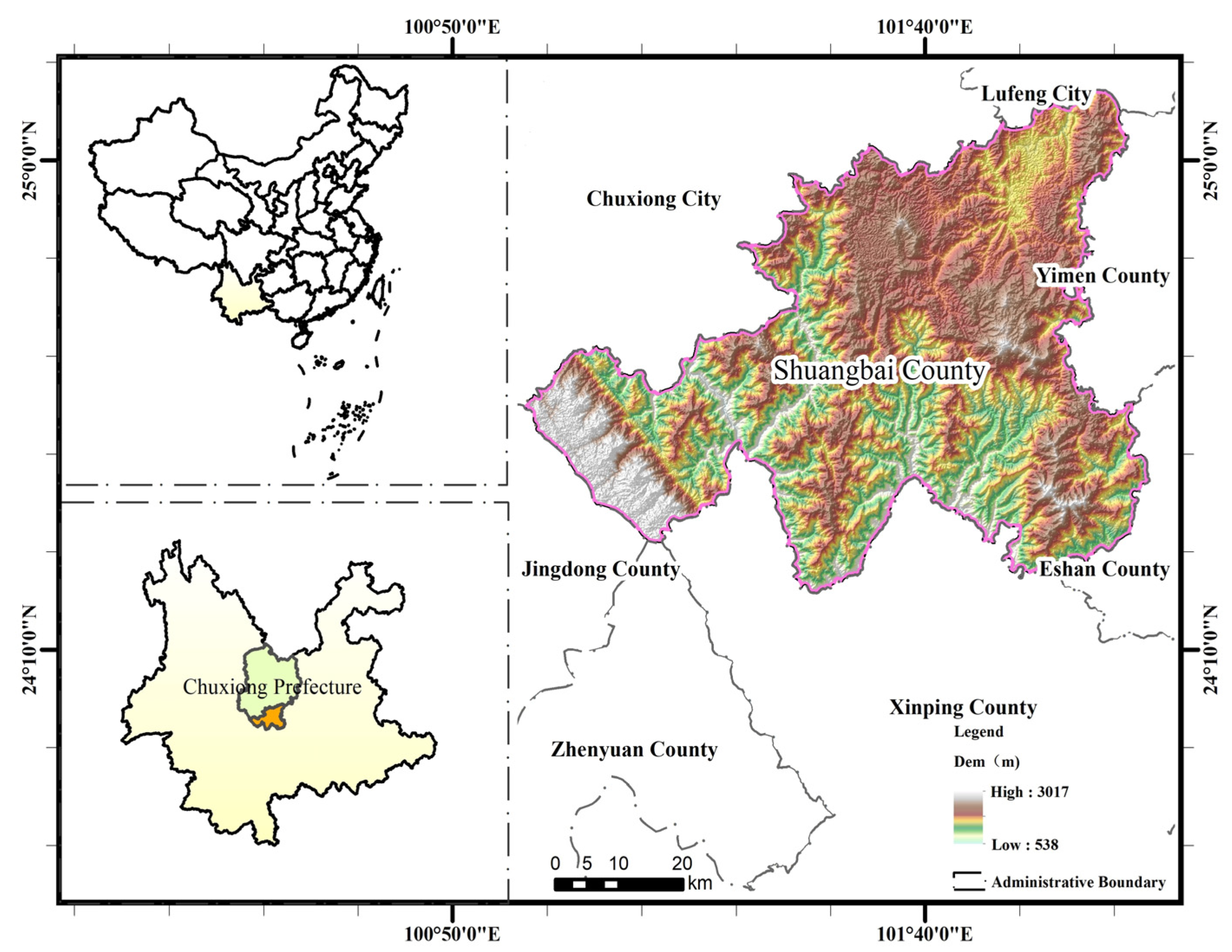
2. Overview of the Study Area

Shuangbai County, nestled within the core of Central Yunnan Province, borders the Miaolun Mountains to the east and the watershed of the Jinsha River and Red River system to the south. It falls under the jurisdiction of the Chuxiong Autonomous Prefecture of Yunnan Province and serves as a confluence for the cities of Chuxiong, Yuxi, and Pu’er. The geographical coordinates for the county extend from 101°03′ E to 102°02′ E, and 24°13′ N to 24°55′ N (Figure 1). The area is characterized by a northern subtropical-highland monsoon climate, marked by its hot and rainy periods and a clear distinction between wet and dry seasons. All river systems within Shuangbai County are part of the Lishe River region in the upper portion of the Red River Basin. This network includes 35 large and small streams and rivers, with the more significant tributaries being the Malong, Lushui, and Shadian Rivers. Positioned on the western edge of Yunnan’s “mountain” front arc and the central segment of the Qinghai, Tibet, Yunnan, and Myanmar “outlaw” tectonic structures, the county covers part of the Nanhua–Chuxiong–Qujiang Fault. These challenging geological conditions contribute to a vulnerable geological environment prone to a myriad of geological disasters. The study and understanding of these dynamics hold considerable theoretical value and practical relevance for local disaster prevention and mitigation efforts.

3. Research Methods and Data Sources

3.1. Research Methodology

3.1.1. Information Volume Model

The information quantity encapsulates both the quality and quantity of data acquired about landslides. The information quantity model (IM) employs the total count of values at the time of a geological hazard’s manifestation to depict its susceptibility. The occurrence of landslides is subject to numerous factors and these factors’ magnitude and roles can vary across different geological environments; hence, there is an optimal combination of factors [18]. Utilizing probability theory, information theory, and engineering geological analogy, the information quantity serves to express the relative probability of landslide occurrence under the compounded effects of various elements. That is to say, a higher information quantity corresponds to an increased likelihood of a landslide occurrence [19,20]. The equation to compute the amount of information is as follows [21,22,23]:
I = ln N i / N S i / S
where N i represents the number of landslides occurring in each classification of the impact factor; N denotes the total number of landslides in the study area; S i represents the number of graded rasters for each influence factor; and S denotes the total number of rasters in the study area. When I > 0, conditions are favorable for landslide occurrence; when I < 0, conditions are unfavorable for landslide occurrence.

3.1.2. Logistic Regression Model

Logistic regression (LR) can be conceptualized as a linear regression model encapsulated within a sigmoid function. In this analysis model, the chosen factor operates as the independent variable, while the existence of a sigmoid (designated as 1 for sigmoid presence and 0 for absence) acts as the dependent variable. Often employed in regression analysis for binary dependent variables, logistic regression represents a non-linear categorical statistical methodology. This model can be articulated using the subsequent expressions [24,25,26]:
Y = β 0 + β 1 x 1 + β 2 x 2 + β n x n
p = e Y 1 + e Y
where β 0 is the constant of logistic regression, while β 1 and β 2 β n represent the logistic regression coefficients corresponding to each factor. p symbolizes the probability of landslide occurrence, and x n represents the nth factor.

3.1.3. Informativeness–Logistic Regression Model

The information quantity model effectively reflects the influence of each factor’s grading on landslides, but it does not easily reveal the contribution rate of each influencing factor. On the other hand, the logistic regression model reflects the influence of each factor’s grading on landslides and provides an overall understanding of their impact. The IM–LR coupled model combines the strengths of both models, considering the influence and grading of factors on landslides. To create non-landslide points for comparison, the same number of points is randomly generated using ArcGIS 10.8. The data of landslide points and non-landslide points are imported into SPSS software, with the information amount as an independent variable and the presence of a landslide point as a dependent variable (1 for yes, 0 for no). The constant term and regression coefficients of the factors are calculated and then substituted into Equations (2) and (3) to obtain the value of p.

3.2. Data Sources

The disaster points, totaling 148 landslides, were obtained from the “Geo-Remote Sensing Ecological Network Scientific Data Registration and Publication System” (www.gisrs.cn, accessed on 1 April 2023). The distribution of these landslides is illustrated in Figure 2. In this region, the landslides are predominantly situated near faults with fractured rock bodies and are also found along water systems and roads. As for the non-hazardous points, they were randomly generated at 1 km intervals using ArcGIS.
In this study, 11 influential factors have been chosen as evaluation metrics for assessing landslide susceptibility in Shuangbai County. The data sources for each respective factor are outlined below (Table 1):

4. Evaluation Unit and Impact Factor Analysis

4.1. Evaluation Module

An evaluation unit, which can be either regular or irregular, represents the smallest spatial element used for assessing susceptibility to geological hazards. Typical types of cells utilized in landslide hazard susceptibility zoning include raster cells, sub-basin cells, and slope cells [27]. In this study, in alignment with previous landslide hazard research and the unique conditions of the area, we opted for raster cells as the evaluation units. To maintain consistency in the number and size of the raster cells across all influencing factors, the raster size is computed according to the following empirical formula [28,29]:
G S = 7.49 + 0.0006 S 2.0 × 10 9 S 2 + 2.9 × 10 15 S 3
where G S represents the empirical raster size, while S signifies the denominator of the scale in the topographic map used to generate the DEM. Following this calculation, an evaluation unit size of 30 m × 30 m was selected. Furthermore, the coordinate system for all layers was standardized to WGS_1984_UTM_Zone_47N, in accordance with the longitude range of the study area.

4.2. Analysis of Impact Factors

Following the determination of the 11 impact factors, we introduced the concept of landslide-relative point density (LRPD). This measure can ascertain the spatial relationship between different gradations of evaluation factors and the geological hazards. The magnitude of the relative point density serves as a reflection of the importance of evaluation factors at all levels in relation to landslide hazard occurrences; a larger value indicates a higher susceptibility of the graded range to landslide occurrences. The calculation formula is as follows:
L R P D = m i / M n i / N
where m i represents the number of landslides within a specific grading, while M signifies the total number of landslides in the study area. Similarly, n i indicates the area of a particular classification, and N denotes the total area of the study area.
(1)
Topography
Elevation: Landslides generally demonstrate a notable pattern in their distribution with elevation [30]. Factors such as vegetation type, sunlight exposure, vegetation cover, degree of weathering, human engineering activities, and rainfall all have certain correlations with elevation. In this study, the natural breakpoint method is employed to divide elevation into six levels, as illustrated in Table 2 and Figure 3a. Elevation within the range of 1659–1914 m registers the highest LRPD, indicating a higher susceptibility for landslide occurrences, whereas the range of 2284–3017 m, with the smallest LRPD, shows lesser susceptibility.
Slope: The slope of the surface unit plays a significant role in landslide formation, with a certain degree of slope being a crucial factor [31]. In this research, ArcGIS is used to perform slope analysis, and the slopes are classified into six classes using ten-degree intervals, as shown in Table 2 and Figure 3b. Landslide occurrences require a specific slope, not excessively steep; a moderate slope ranging from 10° to 20° is more conducive to landslide formation.
Slope Aspect: The slope aspect can impact solar radiation, precipitation, and vegetation cover [32]. Given that the study area is located in the northern hemisphere, the south-facing slopes are sunlit, while the north-facing ones are shaded. In this study, the slope direction is analyzed by ArcGIS. The slope aspect is divided into intervals of 45°: north (337.5°–360.0° and 0°–22.5°), northeast (22.5°–67.5°), east (67.5°–112.5°), southeast (112.5°–157.5°), south (157.5°–202.5°), southwest (202.5°–247.5°), west (247.5°–292.5°), and northwest (292.5°–337.5°). As depicted in Table 2 and Figure 3c, the LRPD values are 1.192151, 1.08671, and 1.368685 for east, northeast, north, and northwest slope aspects, respectively, suggesting that shaded slopes with lesser light, hence poorer vegetation, contribute to weaker slope stabilization; thus, increasing the susceptibility to landslide hazards in this area.
Variations in plane curvature and profile curvature can also significantly impact landslides. In this study, curvature analysis is conducted using ArcGIS. Both plane curvature and profile curvature are divided into six categories, as presented in Table 2, and illustrated in Figure 3j,k. The profile curvature demonstrates the largest LRPD is in the range of 38.0–51.9, with a value of 1.271001, indicating a substantial influence on landslide occurrences. Similarly, the plane curvature showcases its largest LRPD within the range of 0–4.6, with a value of 1.314082, reflecting its considerable impact on landslides.
(2)
Hydrological environment
Proximity to Water Systems: Rivers can influence the stress conditions and physical-mechanical properties of slopes. The rivers in Shuangbai County exhibit significant variations in water level, swift currents, and substantial volume changes. These are predominantly mountainous rivers, which persistently erode slopes, thereby accelerating landslide incidents. This study creates a multi-ring buffer zone through ArcGIS analysis, divided into six tiers, as illustrated in Table 2 and Figure 3i. The LRPD in the 0–300 m range is 1.296010, with the LRPD decreasing as the distance increases. Consequently, the closer the proximity to the water system, the greater the likelihood of a landslide occurrence.
Average Annual Rainfall: Surface-accumulated atmospheric precipitation either infiltrates the ground or enters the slope via surface runoff fissures, thereby facilitating lubrication, erosion, and dissolution [33]. Using the natural breakpoint method through ArcGIS analysis, this study divides the annual rainfall into five levels, as shown in Table 2 and Figure 3g. Landslides tend to occur within the range of 628–721 mm of average annual rainfall, constituting 67.57% of incidents.
(3)
Geological structure and ground cover
Fault Proximity: The distance from a fault line is a significant contributing factor, with greater fragmentation of the geotechnical body closer to the fault. As presented in Table 2 and Figure 3h, this paper classifies the distance from the fault into six categories at 1 km intervals through ArcGIS for multi-ring buffer analysis. Landslides are most prone to occur within the 0–1 km range, exhibiting an LRPD of 1.25916 and constituting 31.76% of landslides.
Normalized Difference Vegetation Index (NDVI): Vegetation exerts a bidirectional effect on slope stability, and landslides can take place across various levels of vegetation cover. The formula is as follows:
N D V I = N I R R N I R + R
The NDVI was calculated using ENVI, where NIR represents the near-infrared band, and R denotes the infrared band. In this paper, the natural breakpoint method was employed to classify NDVI into five categories, as shown in Table 2 and Figure 3f. The maximum LRPD value occurs when the vegetation cover is within the 0.58–0.65 range, a condition conducive to landslide occurrence.
(4)
Stratigraphic lithology
Stratigraphic Lithology: The physical and chemical properties of stratigraphic rocks vary, influencing their resistance to weathering and thus impacting landslide formation [34,35]. In general, hard and harder rocks are less likely to experience landslides than soft rocks, loose rocks, and harder rocks interspersed with soft rocks. As depicted in Table 2 and Figure 3d, in this paper, the geological map is vectorized using ArcGIS, and the stratigraphic lithology is classified into four categories: weak sandwich, softer rock, harder rock, and loose rock. The softer rock demonstrates the highest LRPD value of 1.773527, suggesting that this lithology is conducive to the occurrence of landslides.
(5)
Human engineering activities
Proximity to Roads: Human engineering activities substantially impact landslide susceptibility by disrupting the existing balance [36,37]. The proximity to roads can, to a certain extent, reflect the intensity of human activities. In this paper, a multi-ring buffer is created in ArcGIS and divided into seven levels at 500 m intervals, as shown in Table 2 and Figure 3e. It is observed that the largest LRPD is associated with areas within 500 m of a road. This proximity is conducive to landslide development, primarily because engineering activities, such as slope cutting and improper loading, disrupt the slope’s balance. Generally, areas farther from roads are associated with fewer human activities, thereby leading to fewer landslides.

4.3. Correlation Analysis of Impact Factors

The selection of influencing factors holds paramount importance when assessing landslide hazard susceptibility. When executing the susceptibility analysis through each model, the factors are typically assumed to be mutually independent and non-correlated. This assumption necessitates performing a correlation analysis on these factors to prevent model overfitting. The Pearson correlation coefficient provides a measure of the correlation between two continuous numerical variables [38]. In the context of evaluating landslide susceptibility, it is generally understood that a correlation coefficient within the range of 0 ≤ |PCC| ≤ 0.3 signifies no correlation between factors. As indicated in Table 3, no linear correlation exists among the evaluated factors. Suppose the dataset of the sample ( A i . B j ) = comprises pairs such as (a1, b1), (a2, b2), …, (an, bn). In such a case, the PCC is calculated using the following equation [39,40]:
P C C = i = 1 n a i a ¯ i = 1 n b j b ¯ i = 1 n a i a ¯ 2 i = 1 n b j b ¯ 2
where a i and b j correspond to the values of the variables A i and B j , respectively. a ¯ and b ¯ are the average values of A i and B j , respectively.

5. Analysis of the Landslide Susceptibility Model Evaluation

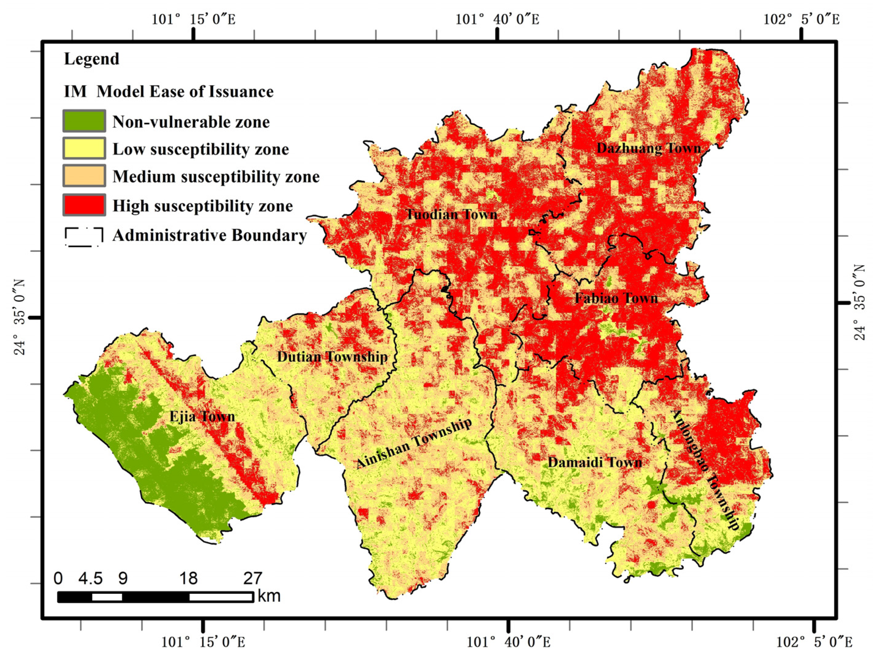
5.1. Information Volume Model Evaluation

Following the correlation analysis among the variables, 11 index factors were determined for the construction of the landslide susceptibility assessment index system. The corresponding information value for each factor state was subsequently calculated in line with Equation (1). Utilizing the raster calculator, the information values of each factor were superimposed, assigning the total information to each raster. A higher information value signifies a higher likelihood of a landslide occurrence, hence providing a measure of landslide susceptibility. By deploying the natural breakpoint method in ArcGIS, landslide-prone areas were categorized into four groups: less-prone, low-prone, medium-prone, and high-prone, as depicted in Figure 4. This resulted in an information-model-based landslide susceptibility zoning map. The proportion of the total area occupied by each category was found to be: less prone (9.01%), low susceptibility (22.46%), medium susceptibility (37.38%), and high susceptibility (31.15%). High-susceptibility areas were predominantly located in Tuodian Township, Anlongbao Township, the central region of Ejia Township, Faju Township, and Dazhuang Township. Conversely, areas of low susceptibility were primarily situated in the western parts of Ejia Township, and the southern regions of Damaidi Township and Aniyama Township.

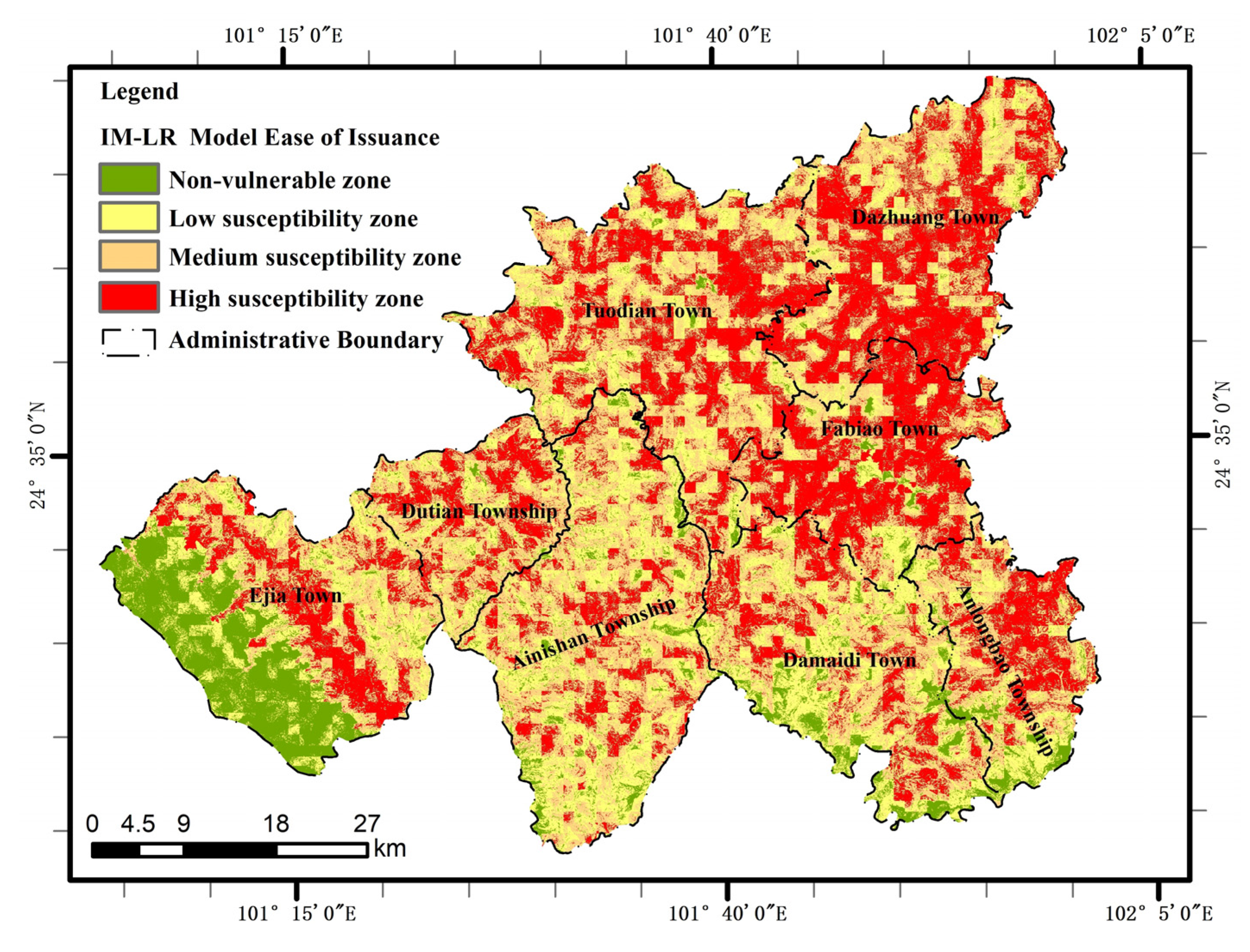
5.2. Informative–Logistic Regression Model Evaluation

Prior to the execution of logistic regression analysis, multicollinearity analysis is conducted for each factor. The analysis shows that all tolerance values exceed 0.1 and all variance inflation factors remain below 10. Consequently, it is determined that all 11 factors can be incorporated into the predictive model. The hybrid informativeness–logistic regression model utilizes the computed informativeness value as the indicator value and undertakes binomial logistic regression analysis employing SPSS software. In this analysis, the informativeness value of each evaluation factor is considered an independent variable, while the potential occurrence of a landslide is treated as the dependent variable. The results of this regression analysis are presented in Table 4. Each factor displays a significance level below 0.05, thereby satisfying the required conditions. The coefficients derived from the analysis are then incorporated into Equations (2) and (3), culminating in the derivation of Equation (8):
P = e Y 1 + e Y Y = 0.053 + 0.791 x 1 + 1.170 x 2 + 1.183 x 3 + 0.730 x 4 + 0.456 x 5 + 0.217 x 6 + 0.836 x 7 + 0.999 x 8 + 1.254 x 9 + 0.909 0.122 x 11
The variables x 1 x 11 represent the information values associated with slope direction, NDVI, distance from the water system, plane curvature, profile curvature, stratigraphic lithology, distance from the road, slope, distance from the fault, elevation, and average annual rainfall, respectively. Using the natural intermittent point method in ArcGIS, these variables are categorized into four grades: less-prone area, low-prone area, medium-prone area, and high-prone area, as depicted in Figure 5. This classification enables the creation of a landslide susceptibility zoning map based on the IM–LR model. The distribution of these areas is as follows: not-likely-to-occur area (9.44%), low-susceptible area (22.00%), medium-susceptible area (36.52%), and high-susceptible area (32.03%). The high-susceptible area is primarily concentrated in the central part of Ejia Township, the eastern part of Anlongbao Township, Fabiao Township, the southern part of Dazhuang Township, and Toudian Township. Conversely, the not-likely-to-occur area and low-susceptible area are concentrated in the western part of Ejia Township, the southern part of Anlongbao Township, Dutian Township, and the southern part of Damaidi Township. Moreover, the town is situated to the west of Ejia Township, the south of Anlongbao Township, the south of Dutian Township, and the south of Damadian Township. From the regression coefficients, it can be observed that the importance of each influencing factor on landslides in the study area is in descending order: distance to fault, distance from water system, NDVI, slope, elevation, distance from road, slope direction, plane curvature, profile curvature, stratigraphic lithology, average annual rainfall.

5.3. Comparative Analysis of Evaluation Model Accuracy Assessments

The accuracy of a model is reflected by the proximity of the ROC curve to the upper left corner [41]. The model’s predictive accuracy is characterized by the size of the AUC value, which represents the area under the ROC curve and the area enclosed by the x-axis. A higher AUC value, closer to 1, indicates a greater prediction accuracy for the tested model. Figure 6 illustrates that the IM model has an AUC value of 0.742, while the IM–LR coupled model has an AUC value of 0.800. Both models exhibit high diagnostic values, but the IM–LR model demonstrates significant improvement compared to the IM model. These findings suggest that the IM–LR model is more suitable for evaluating landslide susceptibility in the study area.
The confusion matrix assesses the model accuracy by quantifying the discrepancies between the actual and model-predicted results. The IM model’s confusion matrix is displayed in Table 5, while the IM–LR model’s confusion matrix is shown in Table 6. The confusion matrix comprises precision and accuracy, which serve as criteria to evaluate the accuracy of the model. Higher precision and accuracy values indicate more accurate model evaluation results. The formulas are as follows:
A c c u r a c y = S U M ( C o r r e c t l y   p r e d i c t e d   s a m p l e   s i z e ) S U M ( T o t a l   S a m p l e   N u m b e r   o f   s a m p l e s )
P r e c i s i o n = S U M ( A c c u r a t e l y   p r e d i c t   t h e   n u m b e r   o f   p o s i t i v e   s a m p l e s ) S U M ( P r e d i c t e d   p o s i t i v e   s a m p l e   s i z e )
The accuracy (68.2%) and precision (70.3%) of the IM model, calculated from Table 5 and Table 6, are lower than the accuracy (72.3%) and precision (73.6%) of the IM–LR model. Therefore, the IM–LR model is more accurate.
The density of landslide occurrences provides a valuable measure of the landslide-to-susceptibility area ratio, serving as a crucial indicator of model performance [42]. Table 7 presents the landslide point densities for various susceptibility classes in the IM model, including less-prone (0.006), low-prone (0.010), medium-prone (0.037), and high-prone (0.068) areas. The results of the information quantity model align with reasonable expectations, as the densities of landslide points increase across susceptibility classes. Similarly, the IM–LR coupled model exhibits increasing landslide point densities for the less-prone (0.005), low-prone (0.012), medium-prone (0.030), and high-prone (0.075) areas. The prediction outcomes of the information quantity model remain reasonable. Notably, the density of landslide points is higher in the information quantity–logistic regression coupled model compared to the IM model. This suggests that the IM–LR model’s predictions are denser in areas with higher susceptibility, closely approximating the actual distribution of landslide points. Consequently, the landslide prediction accuracy is enhanced, which holds significant implications for guiding landslide disaster prevention and control efforts in Shuangbai County.

6. Discussion

Analyzing the susceptibility of the study area, four types of zones have been classified as not susceptible, low susceptible, medium susceptible, and high susceptible, where appropriate land use planning is essential to prevent and mitigate the consequences of disaster occurrence in areas of high susceptibility to landslides. This study provides spatial data related to the distribution of areas prone to landslides, and the zoning maps produced can be used by the authorities to guide the adoption of policies and strategies aimed at mitigating the disaster, and detailed work on the vulnerability of exposed bearers in the central part of Ejia Township, eastern part of Anlongbao Township, Fabiao Township, the southern part of Dazhuang Township, and Toudian Township areas will help in proposing appropriate protective measures. The state of landslide disaster prevention and control in these regions is grim and there is a need to focus on strengthening monitoring and prevention. Prevention and control work should be based on “group monitoring and prevention + relocation and avoidance”, and monitoring needs to be a combination of dynamic monitoring and key monitoring.

7. Conclusions

This paper presents a case study conducted in Shuangbai County, Yunnan Province, focusing on landslide susceptibility evaluation using the information quantity model (IM) and the information quantity–logistic regression model (IM–LR). The accuracy and applicability of both models were examined, leading to the following conclusions:
(1)
An index system comprising slope direction, NDVI, distance from water systems, plane curvature, profile curvature, stratigraphic lithology, distance from roads, slope, distance from faults, elevation, and average annual rainfall was established to construct the landslide susceptibility evaluation models. The IM model and the IM–LR coupled model were utilized to assess susceptibility and derive susceptibility zones. The density of landslide points within each zone was calculated, revealing that the point density increases in the less-susceptible, low-susceptible, medium-susceptible, and high-susceptible areas for both models, aligning with the reasonableness of the models. Notably, the IM–LR coupled model exhibits higher point density in the medium- and high-susceptibility zones compared to the IM model, indicating that the susceptibility zoning of the IM–LR coupled model better approximates reality.
(2)
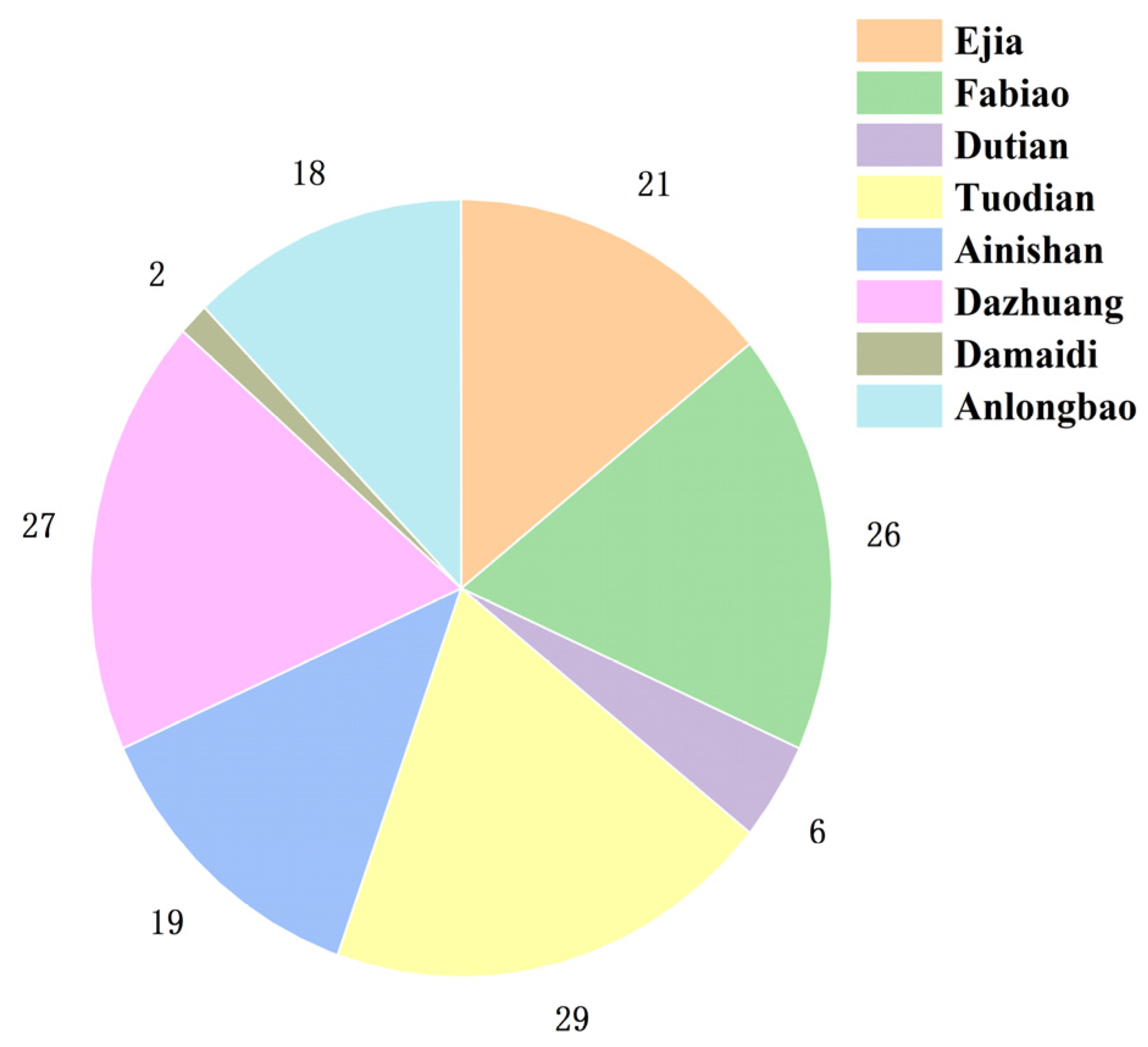
Analysis of the susceptibility zoning map indicates that the high-susceptibility zone is predominantly distributed in the central areas of Ejia Township, the eastern part of Anlongbao Township, Fabiao Township, the southern part of Dazhuang Township, and regions near rivers and roads in Toudian Township. These areas feature lower elevation, less vegetation cover, and increased human engineering activities, contributing to unstable slopes. In contrast, the less-susceptibility and low-susceptibility zones are primarily located in the western part of Ejia Township, the southern part of Anlongbao Township, Duda Township, and the southern part of Damaidi Township. These areas have higher elevation, limited human engineering activities, and more stable slopes.
(3)
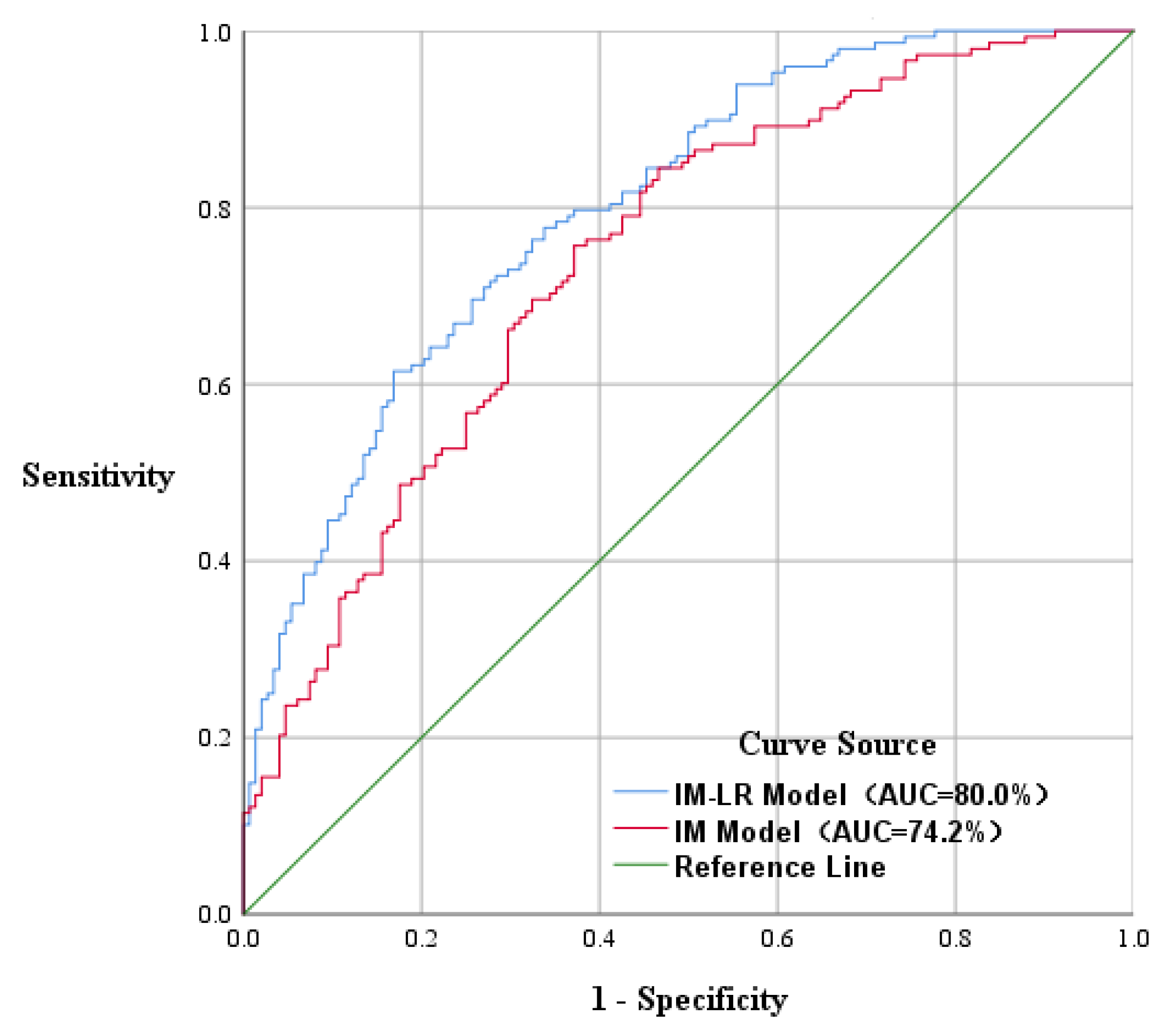
The AUC values of the two models were obtained from the ROC curves. The AUC value of the IM–LR coupled model, 0.800, was larger than that of the IM model, 0.74. Additionally, the accuracy and precision of the IM model were lower than those of the IM–LR model, as obtained from the confusion matrix. These results indicate that the IM–LR coupling model performs better in evaluating the susceptibility of the study area and can provide a more accurate landslide susceptibility zoning for Shuangbai County. This model can serve as a scientific basis for the planning of related departments and a reference for researchers evaluating susceptibility in similar areas.
(4)
Five factors, namely distance to fault, distance from water system, NDVI, slope, and elevation, have significant contributions to the landslide hazard vulnerability in Shuangbai County. Landslides in this region are mainly distributed near roads, water systems, and faults. The probability of landslides decreases with increasing distance from these areas due to relatively broken rocks and poor slope stability. Most landslides occur in the areas of soft rock, loose rock, and softer rock. Additionally, landslides are more likely to occur on shady slopes with medium vegetation cover and significant changes in surface undulation within the elevation range of 1659 m to 1914 m, where the slope is approximately 20°. These findings serve as a valuable reference for geotechnical workers and practitioners in understanding the development characteristics of landslides in the study area.

Author Contributions

All authors contributed to the study conception and design. Material preparation, data collection, and analysis were performed by S.T., H.W., J.Z. and J.X. The first draft of the manuscript was written by H.W., and all authors commented on previous versions of the manuscript. All authors have read and agreed to the published version of the manuscript.

Funding

This work was supported by the Science and Technology Innovation Team Program of Yunnan Province Education Department (Grant NO. CY22624109); the Graduate Tutor Team Program of Yunnan Province Education Department (Grant NO. CY22622205); and Supported by Xing Dian Talent Teacher’s Program of Yunnan Province Education Department (Grant NO. XDTT202206).

Institutional Review Board Statement

Not applicable.

Informed Consent Statement

Not applicable.

Data Availability Statement

The DEM and NDVI data are openly available in [the geospatial data cloud platform] at [https://www.gscloud.cn/], accessed on 11 April 2023. Geological hazard point data and 1:200,000 geological maps are openly available from [the Geographic Remote Sensing Ecology Network platform] at [http://www.gisrs.cn/], accessed on 11 April 2023. Water system and road data can be obtained from [the National Catalogue Service for Geographic Information] at [https://www.webmap.cn/], accessed on 11 April 2023.

Acknowledgments

Thank you for the hard work of laboratory colleagues and the careful guidance of mentors, thank you for funding provided.

Conflicts of Interest

The authors declare no conflict of interest.

References

  1. Alcántara-Ayala, I. Geomorphology, natural hazards, vulnerability and prevention of natural disasters in developing countries. Geomorphology 2002, 47, 107–124. [Google Scholar] [CrossRef]
  2. Ministry of Land and Resources. The Ministry of Land and Resources issued the “Thirteenth Five-Year Plan” for national geological disaster prevention and control. China Emerg. Manag. 2016, 12, 39–44. [Google Scholar]
  3. Shi, Z.; Zhu, H.; Wang, J.; Xin, C. Exploration of soil landslide susceptibility in Xiangxi State from the perspective of coupled model. Res. Soil Water Conserv. 2021, 3, 377–383. [Google Scholar]
  4. Wang, J.; Guo, J.; Wang, W.D.; Fang, L.G. Application and comparison of weight linear combination and logistic regression models in landslide susceptibility zoning. J. Central South Univ. Sci. Technol. 2012, 43, 1932–1939. [Google Scholar]
  5. ur Rehman, Z.; Khalid, U.; Ijaz, N.; Mujtaba, H.; Haider, A.; Farooq, K.; Ijaz, Z. Machine learning-based intelligent modeling of hydraulic conductivity of sandy soils considering a wide range of grain sizes. Eng. Geol. 2022, 311, 106899. [Google Scholar] [CrossRef]
  6. Zhao, J.; Yuan, K. Evaluation of rainfall landslide susceptibility in Ningguo city based on hierarchical analysis model. Shanxi Arch. 2022, 48, 94–96. [Google Scholar]
  7. Ibrahim, M.; Mustaffa, Z.; Balogun, A.; Indra, S.; Ain, A.N. Landslide’s analysis and Hazard mapping based on ANALYTIC HIERARCHY PROCESS (AHP) using GIS, in Lawas, Sabah-Sarawak. IOP Conf. Ser. Earth Environ. Sci. 2022, 1064, 012031. [Google Scholar] [CrossRef]
  8. Zhou, J.; Tan, S.; Li, J.; Xu, J.; Wang, C.; Ye, H. Landslide Susceptibility Assessment Using the Analytic Hierarchy Process (AHP): A Case Study of a Construction Site for Photovoltaic Power Generation in Yunxian County, Southwest China. Sustainability 2023, 15, 5281. [Google Scholar] [CrossRef]
  9. Li, Z.A.; Qin, E.G. Landslide hazard evaluation based on AHP and GIS in Kaiyang County, Guizhou Province. J. Hebei GEO Univ. 2020, 43, 6. [Google Scholar] [CrossRef]
  10. Zangmene, F.L.; Ngapna, M.N.; Ateba, M.C.B.; Mboudou, G.M.M.; Defo, P.L.W.; Kouo, R.T.; Dongmo, A.K.; Owona, S. Landslide susceptibility zonation using the analytical hierarchy process (AHP) in the Bafoussam-Dschang region (West Cameroon). Adv. Space Res. 2023, 71, 5282–5301. [Google Scholar] [CrossRef]
  11. Chen, L.H.; Ye, J.; Wei, C.; Xu, Y.Z. Landslide susceptibility evaluation based on ArcGIS and information quantity method. J. Guangxi Univ. Nat. Sci. Ed. 2016, 41, 141–148. [Google Scholar] [CrossRef]
  12. Deng, N.D.; Cui, Y.Y.; Guo, Y.J. Landslide susceptibility evaluation based on frequency ratio-random forest model. Sci. Technol. Eng. 2020, 20, 7. [Google Scholar] [CrossRef]
  13. Fan, X.; Liu, B.; Luo, J.; Pan, K.; Han, S.; Zhou, Z. Comparison of earthquake-induced shallow landslide susceptibility assessment based on two-category LR and KDE-MLR. Sci. Rep. 2023, 13, 833. [Google Scholar] [CrossRef]
  14. Huang, C.; Li, F.; Wei, L.; Hu, X.; Yang, Y. Landslide susceptibility modeling using a deep random neural network. Appl. Sci. 2022, 12, 12887. [Google Scholar] [CrossRef]
  15. Xu, J.; Zhang, H.; Wen, H.; Sun, D. Study of landslide susceptibility zoning in Wushan County based on logistic regression. J. Chongqing Normal Univ. Nat. Sci. 2021, 38, 48–56. [Google Scholar]
  16. Umar, Z.; Pradhan, B.; Ahmad, A.; Jebur, M.N.; Tehrany, M.S. Earthquake induced landslide susceptibility mapping using an integrated ensemble frequency ratio and logistic regression models in West Sumatera Province, Indonesia. Catena 2014, 118, 124–135. [Google Scholar] [CrossRef]
  17. Tian, Q.; Zhang, B.; Guo, J.F.; Liu, H.Z.; Chang, Z.L.; Li, Y.J.; Huang, F.M. Landslide susceptibility evaluation based on coupled model of information quantity and logistic regression. Sci. Technol. Eng. 2020, 20, 8460–8468. [Google Scholar] [CrossRef]
  18. Wang, J.J.; Yin, K.L.; Xiao, L.L. Evaluation of landslide hazard susceptibility based on GIS and information volume—Taking Wanzhou district in Three Gorges reservoir area as an example. Chin. J. Rock Mech. Eng. 2014, 33, 797–808. [Google Scholar]
  19. Zhang, X.Y. Landslide susceptibility assessment of new Jing-Zhang high-speed railway based on GIS and information value model. J. Geomech. 2018, 24, 96–105. [Google Scholar]
  20. Yang, G.Y.; Zhou, W.; Fang, K.Y. Landslide susceptibility evaluation based on information volume model and data standardization. J. Geo-Inform. Sci. 2018, 20, 674–683. [Google Scholar] [CrossRef]
  21. Xie, W.; Gu, S.; Xiang, X. Zonal evaluation of landslide susceptibility in clastic rock areas based on in-formativeness and multi-model coupling. J. Nat. Haz. 2023, 32, 236–244. [Google Scholar]
  22. Liu, Y.; Meng, Z.; Zhu, L.; Hu, D.; He, H. Optimizing the sample selection of machine learning models for landslide susceptibility prediction using information value models in the Dabie mountain area of Anhui, China. Sustainability 2023, 15, 1971. [Google Scholar] [CrossRef]
  23. Wang, L.; Chang, M.; Xing, Y. Risk assessment of landslide geohazards based on informative method modeling and GIS. J. Geol. Hazards Environ. Preserv. 2021, 14–20. [Google Scholar] [CrossRef]
  24. Li, D.; Huang, F.; Yan, L.; Cao, Z.; Chen, J.; Ye, Z. Landslide susceptibility prediction using particle-swarm-optimized multilayer perceptron: Comparisons with multilayer-perceptron-only, bp neural network, and information value models. Appl. Sci. 2019, 9, 3664. [Google Scholar] [CrossRef]
  25. Tian, C.S.; Liu, X.L.; Wang, J. Evaluation of geological hazard susceptibility in Guangdong Province based on CF and logistic regression model. Hydrogeol. Eng. Geol. 2016, 43, 154–161. [Google Scholar] [CrossRef]
  26. Ou, P. Evaluation of Landslide Disaster Vulnerability in Jiangxi Province Based on Informative Method and Logistic Regression; Donghua University of Science and Technology: Shanghai, China, 2021. [Google Scholar]
  27. Huang, F. Application of Logistic Regression Model in Landslide Disaster Susceptibility Evaluation; Donghua University of Science and Technology: Shanghai, China, 2021. [Google Scholar]
  28. Cong, W.Q.; Pan, M.; Li, T.F.; Wu, Z.; Lv, G.X. Research on key issues of GIS-based landslide and debris flow hazard zoning. Earth Sci. Front. 2006, 13, 185–190. [Google Scholar] [CrossRef]
  29. Li, J.; Zhou, C. Analysis of grid size selection in raster-based GIS landslide risk evaluation method. Nat. Remote Sens. Bull. 2003, 7, 86–92. [Google Scholar]
  30. Skilodimou, H.D.; Bathrellos, G.D.; Koskeridou, E.; Soukis, K.; Rozos, D. Physical and anthropogenic factors related to landslide activity in the Northern Peloponnese, Greece. Land 2018, 7, 85. [Google Scholar] [CrossRef]
  31. Pradhan, B.; Lee, S. Landslide susceptibility assessment and factor effect analysis: Backpropagation artificial neural networks and their comparison with frequency ratio and bivariate logistic regression modelling. Environ. Model. Softw. 2010, 25, 747–759. [Google Scholar] [CrossRef]
  32. Wu, C.R.; Zhao, D.M.; Liu, C.J.; Jiao, Y.M.; Feng, Z.J.; Liu, J. GIS-based analysis of landslide disaster impact factors and evaluation of susceptibility in Huaning County. Res. Soil Water Conserv. 2019, 26, 212–218. [Google Scholar] [CrossRef]
  33. Cai, S.L. Characterization of geologic conditions of landslides and mudslides in Huaining County, Anhui Province, China. Geol. Anhui 2022, 31, 265–269. [Google Scholar]
  34. Ijaz, Z.; Zhao, C.; Ijaz, N.; Rehman, Z.u.; Ijaz, A. Novel application of Google earth engine interpolation algorithm for the development of geotechnical soil maps: A case study of mega-district. Geocarto Int. 2022, 37, 18196–18216. [Google Scholar] [CrossRef]
  35. Ijaz, Z.; Zhao, C.; Ijaz, N.; Rehman, Z.u.; Ijaz, A. Statistical evaluation of multiple interpolation techniques for spatial mapping of highly variable geotechnical facets of soil in natural deposition. Earth Sci. Inform. 2023, 16, 105–129. [Google Scholar] [CrossRef]
  36. Li, Y.; Wang, X.; Mao, H. Influence of human activity on landslide susceptibility development in the Three Gorges area. Nat. Haz. 2020, 104, 2115–2151. [Google Scholar] [CrossRef]
  37. Tian, G.; Guo, Z.; Li, S. Optimization of tawa landslide treatment scheme based on the AHP-fuzzy comprehensive evaluation method. IOP Conf. Ser. Earth Environ. Sci. 2020, 598, 012032. [Google Scholar] [CrossRef]
  38. Fu, T.; Tang, X.; Cai, Z.; Zuo, Y.; Tang, Y.; Zhao, X. Correlation research of phase angle variation and coating performance by means of Pearson’s correlation coefficient. Prog. Org. Coat. 2020, 139, 105459. [Google Scholar] [CrossRef]
  39. Hu, T.Y.; Yang, G.; Chen, B.; Yu, Y.; Tao, Y. ARIMA slope displacement monitoring model based on Pearson’s correlation test. Water Resour. Hydropower Eng. 2016, 47, 71–75. [Google Scholar] [CrossRef]
  40. Nie, S.Y. Ideological evolution of the concept of “correlation” in the history of statistics. China Stat. 2018, 4, 36–38. [Google Scholar]
  41. Zhang, J.; Yin, K.L.; Wang, J.J.; Liu, L.; Huang, F.M. Study on the evaluation of landslide disaster susceptibility in Wanzhou District, Three Gorges Reservoir Area. Chin. J. Rock Mech. Eng. 2016, 35, 284–296. [Google Scholar] [CrossRef]
  42. Cao, J.; Zhang, Z.; Wang, C.; Liu, J.; Zhang, L. Susceptibility assessment of landslides triggered by earthquakes in the Western Sichuan Plateau. Catena 2019, 175, 63–76. [Google Scholar] [CrossRef]
Figure 1. Study area map.
Sustainability 15 12449 g001
Figure 2. Landslide distribution map.
Sustainability 15 12449 g002
Figure 3. Evaluation factor grading chart.
Sustainability 15 12449 g003
Figure 4. Partitions of information volume model susceptibility.
Sustainability 15 12449 g004
Figure 5. IM–LR model susceptibility partitioning.
Sustainability 15 12449 g005
Figure 6. ROC graph.
Sustainability 15 12449 g006
Table 1. Data sources of evaluation indicators.
Data NameData Source
Elevation/(m)
slope/(°)
slope direction/(°)
Geospatial Data Cloud Download DEM (30 m × 30 m)
curvatureGeospatial Data Cloud Download DEM (30 m × 30 m)
Road networkNational Geographic Information Resource Catalog System Download Vector Data (1:200,000)
River DistributionNational Geographic Information Resource Catalog System Download Vector Data (1:200,000)
NDVIGeospatial Data Cloud Download Landsat8 Remote Sensing Imagery (30 m)
Stratigraphic lithology1:1 million geological map
Tectonic distribution1:200,000 geological map
Rainfall/(mm)National Qinghai–Tibet Plateau Science Data Center (1 km)
Table 2. Table of relative point density and information of each classification.
Evaluation FactorsGradingNumber of Graded Grids/(pcs)Number of Landslides/(Places)LRPDI
Elevation/m537–1082421,57770.485030−0.723544
1082–1391730,377261.0398580.039084
1391–16591,017,808381.0906000.086728
1659–19141,106,020501.3205500.278048
1914–2284753,349261.0081500.008117
2284–3017294,11110.099320−2.309409
Slope/(°)<10445,873150.982717−0.017434
10–201,282,431631.4350090.361171
20–301,552,550470.884301−0.122958
30–40839,113220.765862−0.266754
40–50184,11710.158655−1.841020
>5019,16100.0000000.000000
Slope direction/(°)−1.0182500.0000000.000000
0–22.5504,695160.926060−0.076816
22.5–67.5537,602201.0867190.083163
67.5–112.5539,063221.1921510.175759
112.5–157.5577,093170.860501−0.150241
157.5–202.5531,144150.824949−0.192434
202.5–247.5544,319170.912312−0.091773
247.5–292.5532,600150.822694−0.195171
292.5–337.5554,904261.3686850.313851
Distance from road/(km)<0.52,529,3681041.2010720.183215
0.5–1.01,176,748310.769531−0.261974
1.0–1.5437,602100.667527−0.404176
1.5–2.0121,09720.482441−0.728896
2.0–2.533,07510.883177−0.124229
2.5–3.012,79600.0000000.000000
>3.012,55600.0000000.000000
Distance from water system/(m)<3001,803,140801.2960100.259291
300–6001,344,636420.912415−0.091660
600–900773,050210.793523−0.231272
900–1200308,22940.379083−0.969999
1200–150079,09610.369313−0.996110
>150015,09300.0000000.000000
Average annual rainfall/(mm)628–686977,111391.1659190.153510
686–7211,271,026611.4019200.337843
721–7561,037,774240.675548−0.392231
756–801861,463170.576448−0.550870
801–899175,86771.1626820.150730
NDVI0.33–0.48199,04120.293519−1.225814
0.49–0.58572,765201.0200030.019806
0.58–0.651,021,344591.6874380.523212
0.65–0.711,420,985491.0072900.007263
0.71–0.831,109,108180.474074−0.746391
Distance from fault/(km)0–1.01,090,368471.2591360.230426
1.0–2.0928,410310.975371−0.024937
2.0–3.0737,673220.871178−0.137909
3.0–4.0535,742231.2540660.226391
4.0–5.0314,366100.929208−0.073423
>5.0716,685150.611380−0.492037
Stratigraphic lithologyweak sandwich1,232,6441131.0016890.001688
softer rock360,82681.7735270.572970
harder rock1,729,17480.951505−0.049710
soft rock69,89671.7524800.561032
hard rock73,33990.588649−0.529926
loose rock116,06531.0038750.003868
Plane curvature0–14.5834,217270.945437−0.056109
14.5–25.81,014,325371.0655460.063488
25.8–38.0868,071331.1104690.104782
38.0–51.9597,551261.2710010.239805
51.9–67.7461,39380.506485−0.680261
67.7–82.2547,683170.906708−0.097935
Profile curvature0–4.6911,400411.3140820.273138
4.6–8.21,233,856441.0416840.040838
8.2–11.8994,346300.881316−0.126340
11.8–15.9676,942210.906182−0.098515
15.9–21.4377,14190.697086−0.360847
21.4–45.7129,55530.676416−0.390947
Table 3. Table of correlation coefficients between factors.
ABCDEFGHIJK
A1
B0.0511
C−0.0090.0511
D0.009−0.0360.1631
E−0.0590.125−0.001−0.1811
F−0.0080.167−0.016−0.042−0.0261
G0.0230.071−0.032−0.0420.283−0.0341
H0.0070.092−0.013−0.0210.1670.152−0.0011
I0.2170.2990.0250.212−0.2980.0410.0290.1151
J−0.052−0.048−0.112−0.073−0.033−0.001−0.002−0.099−0.0711
K−0.0760.1580.114−0.2990.2590.142−0.0220.072−0.221−0.0731
Note: A–K indicate distance from fault, NDVI, profile curvature, plane curvature, average annual rainfall, distance from road, stratigraphic lithology, distance from water system, elevation, slope direction, and slope, respectively.
Table 4. Coupling model coefficients.
FactorRegression CoefficientSignificance
Slope direction0.7910
NDVI1.1700.017
Distance from water system1.1830.007
Plane curvature0.7300.028
Profile curvature0.4650
Stratigraphic lithology0.2170.011
Distance from road0.8360
Slope0.9990.003
Distance to fault1.2540.003
Elevation0.9090.002
Average annual rainfall−0.1220
Constants0.0530
Table 5. IM Confusion Matrix.
Projected Value
01
real value09850
144104
Table 6. IM–LR Confusion Matrix.
Projected Value
01
real value010543
139109
Table 7. Landslide susceptibility zoning statistics.
Evaluation ModelVulnerability ZonesNo. of Landslides (Places)Landslide Site Density (Places/ k m 2 )
IMNon-prone areas20.006
Low-susceptibility area90.010
Medium-prone areas540.037
Highly susceptible areas830.068
IM–LRNon-prone areas20.005
Low-susceptibility area100.012
Medium-prone areas430.030
Highly susceptible areas930.075
Disclaimer/Publisher’s Note: The statements, opinions and data contained in all publications are solely those of the individual author(s) and contributor(s) and not of MDPI and/or the editor(s). MDPI and/or the editor(s) disclaim responsibility for any injury to people or property resulting from any ideas, methods, instructions or products referred to in the content.

