Article

Evaluation of Urban Resource Environmental Carrying Capacity and Land Spatial Development Suitability in a Semiarid Area of the Yellow River Basin

1
Inner Mongolia Key Laboratory of Aeolian Physics and Desertification Engineering, Desert Science and Engineering College, Inner Mongolia Agricultural University, Hohhot 010018, China
2
Key Laboratory of State Forest Administration for Desert Ecosystem Protection and Restoration, Desert Science and Engineering College, Inner Mongolia Agricultural University, Hohhot 010018, China
*
Author to whom correspondence should be addressed.
Sustainability 2023, 15(16), 12411; https://doi.org/10.3390/su151612411
Submission received: 24 March 2023 / Revised: 8 June 2023 / Accepted: 12 June 2023 / Published: 15 August 2023
(This article belongs to the Section Hazards and Sustainability)

Abstract

:
At present, the carrying capacity of resources and the environment in some areas has reached an upper limit, and the problems of ecological destruction and environmental pollution have become increasingly prominent. The overexploitation and disorderly development of land space, resulting in the spatial imbalance between the population economy and the resource environment, is one of the root causes of excessive resource consumption, ecological degradation, and environmental pollution. Resource and environmental carrying capacity and suitability evaluation of land space development is the basis of land space planning. It provides conditions for the modernization of land space governance. The framework provided by the “ Double Evaluation Guide (Trial) “ is universal. It is necessary to adapt it to local conditions and to achieve the ” Double Evalution” results, according to the characteristics of regional development. Taking Hohhot as the research area, which is based on the “Guide”, involves selecting convincing and credible evaluation factors and using the single factor integration method and the discriminant matrix method. The “double evaluation” of Hohhot was also analyzed. This provides basic data for regional high-quality development and land space planning. The results show the following: (1) The ecological function of Hohhot is good. The areas with low importance for ecological protection accounted for about 18%, the areas with medium ecological protection accounted for about 62%, and the areas with high ecological protection accounted for about 21%. (2) The carrying capacity of agricultural function in Hohhot is medium. The carrying capacity of the low polar region accounted for about 23%, the medium polar region’s carrying capacity accounted for about 71%, and the high polar region’s carrying capacity accounted for about 6%. (3) The urban function carrying capacity of Hohhot is medium. The carrying capacity of the low-grade area accounted for about 25%, the medium-grade area’s carrying capacity accounted for about 55%, and the high-grade area’s carrying capacity accounted for about 21%. (4) The overall agricultural production suitability grade of Hohhot is not suitable. (5) The suitability of urban construction in Hohhot is general. The unsuitable area accounts for about 40%, the more suitable area accounts for about 45%, and the most suitable area accounts for about 15%.

1. Introduction

1.1. Research Purpose

At this stage, China’s economy is developing rapidly, and the urbanization process is accelerating and has entered a new stage of development. China is actively promoting the construction of ecological civilization [1]. However, at the same time, it also ignores the rational use and protection of land space, and it faces many new problems and challenges, resulting in waste of resources, environmental pollution, deterioration of ecological environment, and the intensification of various conflicts [2,3]. Rational development and utilization of cities are important guarantees to revitalize the economy of semi-arid regions, and they are also key factors to promote the healthy development of ecosystems [4]. “Double evaluation” is the cornerstone of territorial space planning and a prerequisite for green development and ecological priority in the new era [5]. Therefore, the study of “double evaluation” plays a decisive role in the green and efficient development of the region.
The research idea of “double evaluation” originates from the “Technical Guide for Evaluating the Carrying Capacity of Resources and Environment and the Suitability of Land and Space Development”, which is universal in the country. However, the development of various regions in the country is different. It is necessary to adjust measures in relation to local conditions and to formulate a planning system with local characteristics. “Double evaluation” of the region can identify the status and characteristics of regional development and provide the basis for the formulation of regional development strategies [6]. This paper takes Hohhot as the research object, constructs an index system with Hohhot’s characteristics, based on local development characteristics and the current situation, and evaluates the suitability of land development and the carrying capacity of resources and the environment so as to provide a basis for regional spatial development and protection patterns and to promote the high-quality development of space [7].

1.2. Research Status at Home and Abroad

In 2009, Tian Hongling and other GIS tools were used to rasterize the study area, which measured 3 km × 3 km, and it overlaid various factor layers. It was concluded that the bearing capacity distribution of the Chengdu disaster area is obviously different, the bearing capacity of the eastern plain is strong, and the bearing capacity of the western mountainous area is poor [8]. In 2010, Wu Bin used the principal component analysis method to comprehensively evaluate the resource and environmental carrying capacity of Shenzhen, and Bin found that the resource and environmental carrying capacity of Shenzhen showed a downward trend, in general, from 2000 to 2007. Especially after 2003, the situation was more severe due to the influence of resource development and utilization efficiency, ecological environment quality, and economic development level [9]. In 2011, Gao et al. used the similarity evaluation model to comprehensively evaluate and analyze the water resource carrying capacity of Ordos City, and they found that the development and utilization of water resources in Ordos City had a considerable scale, and regional water transfer projects could be implemented to solve the problem of water [10]. In 2013, Wang et al. selected topography, land use, and other indicators to establish the index system of resource and environmental carrying capacity in Ganzhou City. GIS technology and the analytic hierarchy process were applied to determine the weight in combination with the actual situation. The results showed that the resource and environmental carrying capacities in Ganzhou City were close to saturation, and the city should adhere to the parallel development and utilization of resources [11]. In 2019, Shao Yanpo and others took Rongcheng City as their research object, established an evaluation index system of resources and environmental carrying capacity, and realized the spatialization of attribute data, which was based on GIS technology. The results showed that the basic evaluation of resources and environment in Rongcheng City was loadable, and the comprehensive carrying state, based on ecological conditions and environmental quality system, was loadable [12]. In 2021, Wang Mingtao selected Etuoke Banner as the study area to construct the evaluation index system of regional resources and environmental carrying capacity, and Mingtao proposed 20 evaluation indexes of environmental, social, and economic subsystems. Using the TOPSIS comprehensive evaluation method, it was concluded that the level of regional carrying capacity has fluctuated from 2011 to 2018, but the overall trend is on the rise.
Beginning in the early 1990s, domestic scholars began to pay attention to the relationship between land spatial suitability evaluation and spatial allocation of land resources. In 2007, Liang et al. used the spatial data analysis and visualization function of GIS to propose a practical method for generating the spatial distribution of ecological suitability of comprehensive urban land by weighted superposition of single factors, and they accurately characterized the ecological suitability intensity of different types of land from space [13]. In 2012, Tang Changchun and others used the Yangtze River Basin as a research area and used Delphi and AHP methods to construct a suitability index system of land space development. Combined with the GIS spatial clustering method, single factor classification evaluation was carried out. The dynamic weighted summation method was used to establish the evaluation, and the coupling difference coefficient was constructed to carry out the evaluation [14]. In 2016, taking the city of Ji’an as the research area, Deng Yan calculated the development potential score according to the comprehensive index method model and analyzed the characteristics of development intensity based on GIS platform and statistical methods. In 2018, Wang Lili constructed a county-level land development suitability evaluation technology system based on a GIS grid based on land use status data, meteorological data, and disaster data. In 2021, Huang Shujuan and others took Shishou City as the research object and carried out weighted superposition analysis on the elements of urban ecology, economy, and social benefits through GIS. In addition, the factors affecting urban ecological security were analyzed [15].
Kyushik et al. evaluated the land carrying capacity of Seoul through the UCCAS evaluation system. Dongwoo Lee used GIS grid technology to evaluate the environmental carrying capacity of the regional development density allocation model [16].
From the end of the 19th century to the beginning of the 20th century, land spatial suitability evaluation based on GIS gradually replaced the manual drawing and superposition of images. According to the method and model of the ecological zone plan of the United Nations Food Security Organization, Davidson selected indicators such as climate type and crop growth demand to evaluate the suitability of land for different crops [17]. Henrik et al. used the fuzzy comprehensive evaluation method to select indicators such as land use status, environmental status, resource availability and biodiversity to construct the evaluation index system of the development suitability of the coastal zone in the Hadapur region. Sudabe Jafari et al. constructed an evaluation index system composed of climate, soil, topography, and distance from rivers and settlements, and used the spatial overlay analysis method to evaluate the suitability of pastures in the Tarigan Basin, Iran. The evaluation results were divided into three grades: unsuitable, moderately suitable, and highly suitable [18].

1.3. Highlights of Paper

At present, most of the research on double evaluation focuses on the provincial scale and large spatial scale, lacking comprehensiveness and universality, and there are few studies on the scale of smaller cities. This paper takes Hohhot as the research area and carries out detailed evaluation and analysis of each single factor evaluation in the evaluation of resource and environmental carrying capacity and land space development suitability. Each small evaluation can provide the basis for the double evaluation of Hohhot, making the analysis results more suitable for local conditions and in line with local development characteristics. The evaluation results are more detailed and specific, and the preparation of land and space planning has more regional development characteristics.

2. Materials and Methods

2.1. Natural Overview of the Study Area

Hohhot is located in north China, in the central Inner Mongolia Autonomous Region. The city’s total area is 17,200 square kilometers, including a built-up area of 260 square kilometers. The territory is mainly divided into two major geomorphic units. The northern Daqing Mountain and the southeastern Manhan Mountain are mountainous terrain, and the southern and southwestern parts are Tumochuan plain terrain. The terrain inclines gradually from northeast to southwest [19]. Hohhot is subject to a temperate continental monsoon climate; the four seasons of climate change significantly. The differences between seasons are great and characterized by the following: long cold winter; short-lived, hot summer; spring and autumn climate change [20]. The annual average temperature increases from north to south. The annual average temperature difference is 34.4–35.7 °C and the daily average temperature difference is l3.5–13.7 °C. Precipitation: the average annual precipitation is 335.2–534.6 mm. The annual precipitation in the southwest region is the least (only 350 mm). At present, the main water used in the construction area comes from the Yellow River water, which undoubtedly limits the exploitation and utilization of groundwater Yellow River water has a high sediment content and forms deposits easily, which increases the possibility of floods and causes natural disasters. Therefore, these problems should be paid attention to in future development and water utilization. The characteristics of vegetation distribution are as follows: from south to north, forest vegetation gradually transition to shrub grassland, dry grassland, and meadow grassland, and from east to west, rocky vegetation transitions to marsh vegetation and sand vegetation. According to the second soil survey, the soil types in Hohhot are complex, with a total of 12 soil types. The nutrient content of cultivated soil is generally low (Figure 1).

2.2. Data Sources

The data used in this paper are land use data, DEM elevation, meteorological data, light and heat data, terrain data, etc., including geospatial data and survey data. Geospatial data mainly include vector and raster data such as basic geography, land resources, water resources, environment, ecology, and climate. Land use data, DEM elevation, and photothermal data were derived from the Resource and Environmental Science Data Center of the Chinese Academy of Sciences. Terrain data were sourced from the geological cloud, based on DEM data using ArcGIS slope calculation tool to obtain Hohhot’s slope. Various types of survey statistics were primarily obtained from weather stations’ data (for many years), climate statistics, meteorological data, and environmental data mainly from the national meteorological and climate departments. Climatic data included temperature, precipitation, and other data. The observation data of national climate departments and meteorological stations were extracted using spatial interpolation in ArcGIS 10.2 software.
Land resource data mainly include land use type, soil texture, terrain slope, and undulation data. The data of land use types were obtained through the website of the Resource and Environmental Science Data Center of the Chinese Academy of Sciences and extracted by ArcGIS software for further data analysis. The soil texture data were obtained from the website of the Resource and Environmental Science Data Center of the Chinese Academy of Sciences, and the soil texture of the study area was obtained by using the inverse distance weight interpolation method of ArcGIS software. The terrain slope uses the slope calculation tool of ArcGIS software to analyze and calculate the DEM data of the study area. The topographic relief degree uses the focus statistical tool of ArcGIS software to analyze and calculate the DEM data of the study area.

2.3. Double Evaluation Index System

2.3.1. Spatial Characteristics of Hohhot

The climate change in Hohhot is obvious in four seasons, and the difference is large, especially in spring and autumn. Climate change is severe, and the meteorological indicators need to be considered. The average annual precipitation is 335.2–534.6 mm, with the southwest region receiving the least precipitation (only 350 mm). The selection of waterlogging agricultural disaster indicators can be simplified, and the selection of indicators such as soil erosion and arid agriculture should be considered. There are more mountains and peaks in the territory, terrain, and slope, and other indicators need to be included in the selection [21].

2.3.2. Construction of Index System

Taking the “Guide” as the reference standard, the evaluation method used in the “Guide” is used to select the index, and the calculation method is provided. Combined with the spatial characteristics of Hohhot, considering the restrictive factors of evaluation data acquisition, the single factor evaluation index of resource environment carrying capacity (Table 1) and land space development suitability (Table 2) is selected according to local conditions [22]. The relevant information of the variable is provided in the subsequent result analysis.

2.4. Research Method

The carrying capacity of resources and environment refers to the ability of the environmental system to withstand human economic and social activities while resources can ensure sustainable development and steady operation in a region. In this paper, Hohhot is taken as the research area, and the index factors with regional development characteristics, such as light and heat conditions, biodiversity, land resources and terrain conditions, are selected to evaluate and classify the carrying capacity of space resources and environment [29].
Suitability evaluation of land space development refers to the analysis and evaluation of the suitability of land space development, with the 500 m × 500 m network of the land space of the administrative region above the county level as the basic unit, by combining quantitative and qualitative analysis [30]. Taking Hohhot as the research area, this paper chooses land resources, water supply conditions, and other index factors to classify and evaluate the suitability of land space development.

2.5. Technology Roadmap

The technology roadmap is constructed from three aspects of ecology, agriculture and urban (Figure 2).

3. Results

3.1. Evaluation of the Carrying Capacity of Resources and Environment

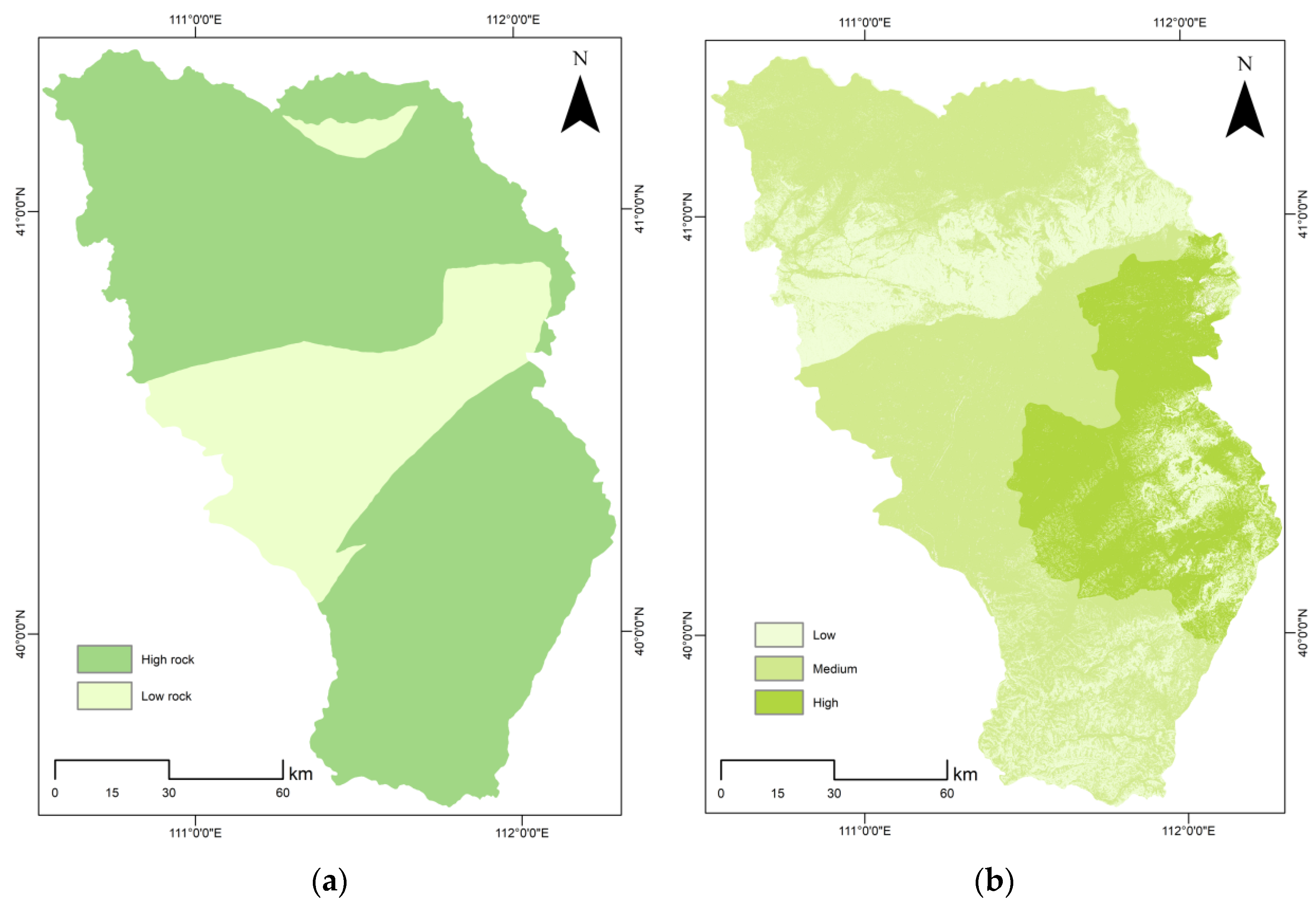
3.1.1. Evaluation of the Importance of Ecological Protection Function

Environmental Assessment of Single Element

Importance of evaluation of water conservation function:
w a t e r   c o n s e r v a t i o n   ( T Q ) = Σ i j ( P i R i E T i ) × A i × 10 3
where P i is rain fall (mm), R i is surface runoff (mm), E T i is evapotranspiration (mm), A i is the area of ecosystem i (km2), i is Type I ecosystem in the study area, and j is the number of ecosystem types in the study area.
In the evaluation of the importance of water conservation function, the comprehensive index method is generally used to establish a regional evaluation model. It divides the importance of water conservation function into several indicators, determines the factors affecting each index, selects them as evaluation factors, and obtains the index in the index. Then, according to the weight, the total index is superimposed to obtain the importance index of the water conservation function.
The analysis of the water conservation function is mainly obtained by precipitation, ecosystem type, surface coverage, and basic geographic information [31]. The importance evaluation map of the water conservation function in Hohhot was calculated and graded by GIS according to mask extraction, fusion, precision adjustment, and other tools.
In our conception of the importance evaluation of the water conservation function based on GIS in Henan Province, we observed that the important areas of water conservation in the Yellow River Basin of Henan Province are relatively concentrated, the most important general areas account for the largest proportion, and the relationship between water conservation and land use types is inseparable [32]. The water conservation capacity of Hohhot is general (Figure 3), showing a large spatial distribution of differentiation. Important areas and extremely important areas are rarely distributed, and the city is dominated by general areas. Important areas are only distributed in the north, the largest area of general conservation capacity.
Evaluation of the importance of soil and water conservation function:
s o i l   a n d   w a t e r   c o n s e r v a t i o n ( A ) = R × K × L × S × ( 1 C )
where R indicates the rainfall erosivity factor (MJ·mm/hm2·h·a), K is the soil erodibility factor (t·hm2·h/hm2·MJ·mm), L is the slope length factor, S is the slope factor, and C is the vegetation factor.
The importance evaluation of the soil and water conservation function generally involves three index factors: ecosystem type factor, vegetation coverage factor, and terrain slope factor. At present, vegetation coverage data are mainly extracted from remote sensing images, with 30 m resolution images as the main data source. The terrain selected in this paper are the data with DEM resolution of 30 m. The terrain slope factor can be obtained by using DEM data through the slope analysis tool in ArcGIS software [33].
The function of soil and water conservation is mainly related to climate, soil, topography, and vegetation. The difference between potential soil erosion and actual soil erosion is taken as the evaluation index. According to the actual situation of Hohhot, the three factors of ecosystem type, vegetation coverage, and topographic slope are selected, and the data are calculated by using GIS grid mosaic and NDVI data according to mask extraction [34]. Finally, the attributes are graded and adjusted. In the importance evaluation of soil and water conservation function in Fujian Province based on GIS, it is found that the proportion of generally important areas is the largest [35]. The overall soil and water conservation capacity of Hohhot is general (Figure 3). The general area of soil and water conservation is large, the central and western regions are important areas of soil and water conservation, and the extremely important area is the smallest, mainly in the general area.
Evaluation of the importance of biodiversity maintenance function:
B i o d i v e r s i t y   m a i n t e n a n c e   s e r v i c e   c a p a b i l i t y   i n d e x   ( S b i o ) = N P P m e a n × F p r e × F t e m × ( 1 F a l t )
where N P P m e a n is the average annual net primary productivity of vegetation, F p r e is the mean annual precipitation, F t e m is the perennial mean temperature, and F a l t is the elevation factor.
For the assessment of the importance of biodiversity conservation functions, the NPP method was used to calculate the importance of biodiversity conservation functions based on the collection of available data [36].
The importance of biodiversity conservation function is evaluated at three levels: ecosystem type, species, and genetic resources. Taking Hohhot as the research unit, according to the NPP dataset, meteorological data, elevation dataset, and other data, using GIS grid interpolation command, and referring to the “Ecological Protection Red Line Delineation Guidelines”, the data of each factor are normalized, and finally the corresponding grid value is expressed hierarchically [37].
In the study of double evaluation of land spatial planning based on county scale, it is found that the extremely important areas of biodiversity maintenance function are distributed in the south, the important areas are distributed in the middle, and the general important areas are distributed in the north. The ecosystem types in Hohhot are mainly farmland, forest, wetland, shrub, grassland, and urban settlements. Farmland and grassland cover the largest area, and forests and urban settlements are scattered (Figure 4). Because of the correlation between biodiversity and ecosystem types, the biodiversity in Hohhot is generally good. The extremely important areas and important areas are concentrated in the south, and the general areas are mainly distributed in the north (Figure 4).
Ecological vulnerability assessment:
[ V u l n e r a b i l i t y   o f   s o i l   e r o s i o n ] = R × K × L S × C 4
where R indicates the vulnerability classification value of rainfall erosivity factor, K is the vulnerability grading value of soil erodibility factor, L S is the vulnerability classification value of topographic relief factor, C is the vulnerability classification of vegetation cover factor.
According to the “Guide”, the assignment method of each factor is shown in the table (Table 3).
Referring to the construction of ecological vulnerability model adopted by Zhong Zhaoquan [38], the weights of slope, soil K factor, average annual precipitation, NDVI, and population density are obtained by using principal component analysis method based on IBM SPSS Statistics through the evaluation index values of randomly generated points, indicating the factors that mainly affected the ecological vulnerability of the study area.
Combined with the actual situation in Hohhot, there are too few vulnerability problems, such as rocky desertification and desertification, in ecological vulnerability. Therefore, the ecological vulnerability assessment only studies the vulnerability assessment of soil erosion.
Similar to the above soil and water conservation functions, data such as vegetation coverage data, terrain data, soil texture data, and rainfall erosivity factor were selected, and GIS was used to assign and interpolate the Hohhot area to form raster data, which was then reclassified for hierarchical expression.
In the study of ecological vulnerability assessment in Naiman Banner, Inner Mongolia, it was found that the degree of vulnerability was mainly mild and that the ecological environment was moderately fragile. The vulnerability and resource distribution areas are quite different, and the minimum proportion of extremely fragile area is also the smallest. It can be seen from the figure that the overall ecological vulnerability of Hohhot is low mainly distributed in low-vulnerability areas, with fewer medium-vulnerability areas, distributed only in the north, and no high-vulnerability areas (Figure 5).

Integrative Assessment

According to the above single factor evaluation results, the highest level of ecosystem service function importance and ecological vulnerability evaluation results is taken, and the mosaic function is used for overlay analysis in GIS to obtain the initial judgment result of ecological protection importance. Then, the initial judgment result is corrected, and the adjacent patches of the corresponding level are aggregated. According to the scale of the aggregated plots, the patch concentration level is determined. According to the evaluation level, the importance level of ecological protection is determined and evaluated.
In the evaluation of the importance of ecological protection in Kunming for land and space planning, it was found that the proportion of high and higher importance of ecological protection in Kunming was 30.1%. From the perspective of evaluation factors, the importance of biodiversity maintenance function is the most important factor contributing to the ecological importance of Kunming [39]. The ecological function of Hohhot is good (Figure 5). The importance levels of ecological protection are low, medium, and high, accounting for about 18%, 62% and 21%, respectively. The overall ecological protection is good. The lower areas are scattered in the central and northern parts, and the higher areas are concentrated in the south. A small number are in the north, and the medium area accounts for the largest area. The region belongs to the area of frequent human activities, which shows that the ecological environment will be affected by human activities. Hohhot is located in the piedmont plain. It possesses a good groundwater storage structure and is protected by water resources. Moreover, the ecosystem types are mainly farmland and grassland, with good biodiversity and low vulnerability to soil erosion, which makes the ecological protection function higher. In the future, more attention should be paid to territorial space protection.

3.1.2. Evaluation of Agricultural Function Carrying Capacity

Environmental Assessment of Single Element

Evaluation of photothermal conditions:
[ light   and   heat   conditions ] = f ( Accumulated   temperature   interpolation )
Through the statistics of Hohhot meteorological station, using 10 years of daily average temperature ≥ 0 °C active accumulated temperature and GIS for accumulated temperature interpolation, combined with altitude correction and topographic data, the active accumulated temperature layer was obtained. Finally, the active accumulated temperature classification map was generated according to each grade.
In the study of double evaluation of land and space planning based on county scale, it was found that the overall light and temperature production potential was general, the spatial distribution of grades was stepped, and the potential gradually increased from west to east. The light and temperature conditions in the western region had little effect on crop growth. It can be seen from the diagram that the overall light and heat production potential of Hohhot is poor (Figure 6). From crops up to one year old, distributed in the south and central, and crops less than one year old concentrated in the north, it can be seen that light and heat conditions for crop growth support are very low; light and heat conditions are poor.
Evaluation of agricultural water supply conditions
[   r i c h n e s s   o f   w a t e r   r e s o u r c e ] = f ( [ p r e c i p i t a t i o n ] ,   [ w a t e r   a v a i l a b i l i t y ] )
The evaluation index of agricultural water supply condition is obtained from 10-year average precipitation data and meteorological station data, which is reflected by the spatial distribution of water resources. The precipitation data were processed in the evaluation of the importance of biodiversity maintenance function, and then were interpolated with meteorological data to extract the range of Hohhot. The multiyear average precipitation distribution layer was obtained by spatial interpolation, and the water supply condition map of Hohhot City was obtained according to the distribution of each grade [40].
In the study of double evaluation of land spatial planning based on county scale, it is found that the spatial distribution characteristics of multiyear average precipitation are generally more in the south and less in the north and show a decreasing trend from south to north. The multiyear average precipitation level in Xiangzhou District is better, which corresponds to the humid conditions, and the water resources evaluation results are better. The grade of agricultural water supply conditions in Hohhot is generally poor (Figure 6). Semi-arid and semi-humid regions dominate, semi-arid regions are concentrated in the north while semi-humid areas are distributed in the south and central regions.
Land resource evaluation:
[ A g r i c u l t u r a l   f a r m i n g   c o n d i t i o n s ] = f ( [ g r a d i e n t ] ,     [ e l e v a t i o n ] )
The evaluation of land resources in the face of agriculture refers to the degree to which land resources are suitable for agricultural production. The slope, elevation, and soil texture are selected as the index factors to construct the analytic hierarchy discriminant matrix, and the AHP analytic hierarchy process is used to calculate the weight of each factor evaluation result for land resources [41].
According to the geographical location of Hohhot, the projection coordinate system was set up by using GIS, the terrain slope was calculated according to DEM, and the slope grading map was generated after grading according to the slope. Based on the grading results, combined with the soil texture, the attribute selection and assignment of the two were carried out by using the identification tool, the grade of agricultural cultivation conditions was divided, and the land resource evaluation map was generated [42].
In the “double evaluation” method of provincial land resources evaluation, it was found that land resources evaluated at low, medium, and high levels accounted for the largest proportion [43]. The overall land resource environment in Hohhot is poor (Figure 7). Inappropriate and more appropriate resource environments are accorded priority. The most appropriate resource environment proportion is the smallest proportion, inappropriate and more appropriate resource environment is found throughout the entire study area, the most suitable environments are found in the west and central regions, and spatial distribution is scattered.
Drought agriculture disaster evaluation:
[ Drought   agricultural   disasters ] = f ( Grid   interpolation )
Taking precipitation data and meteorological data as indicators, the precipitation data were processed by grid interpolation analysis, and the scope of Hohhot was extracted according to the mask. According to the drought grade table of precipitation anomaly percentage, the drought grade was determined, and the drought frequency was calculated.
Hohhot, as a whole, does not show a tendency for droughts. Overall, the drought-related situation is good (Figure 7).

Integrative Assessment

According to the above single factor evaluation results, the highest level of agricultural water supply conditions and land resources evaluation is obtained, and the mosaic function is used in GIS to perform overlay analysis to obtain the basis of water and soil resources. Using the highest level of the evaluation results of the three indicators of light and heat conditions and soil environmental capacity, and using the mosaic tool, the evaluation results of agricultural functional carrying capacity in Hohhot are obtained.
In the study of double evaluation of land and space planning based on county scale, through the exploration of the four aspects of land resources, water resources, climate, and environmental evaluation, the maximum area of agricultural production is 2399.42 square kilometers. The carrying scale of agricultural production in Xiangzhou District was analyzed and evaluated. Taking vegetation coverage as the index factor of agricultural function carrying capacity, the vegetation coverage level in Hohhot is low (Figure 8). Low-, medium-, and high-level areas accounted for about 48%, 45%, and 6% of the total, respectively, reflecting an uneven distribution. The level of agricultural functional carrying capacity in Hohhot is medium (Figure 8). The low-, medium-, and high-grade areas accounted for about 23%, 71%, and 6% respectively. The areas with better carrying capacity are concentrated in the south and middle, and the spatial distribution in the north is uneven. The soil environment in the region is excellent. The water and soil resources and the light and heat conditions in Hohhot are poor, and they are distributed in the urban expansion area. Soil pollution limits the quality of agricultural products and limits the overall carrying capacity of the entire region.

3.1.3. Evaluation of Urban Functional Carrying Capacity

Environmental Assessment of Single Element

Evaluation of urban water supply conditions:
[ richness   of   water   resource ] = f ( [ precipitation ] , [ water   availability ] )
The water supply condition is mainly reflected by the water production modulus. Taking Hohhot as the research unit, hydrological analysis was carried out according to the topographic data processed in the evaluation of the importance of the soil and water conservation function, the catchment basin was extracted, and the water resources were divided according to the total amount of water resources, resulting in grades of water resources and evaluation maps.
In the double evaluation study of land and space planning based on county scale, it is found that the total water yield modulus of water resources in Xiangzhou District is 157,000 m3/km2, and the water resources evaluation grade is general, which is divided into five grades: good, better, general, worse, and poor. The overall water supply conditions in Hohhot are poor (Figure 9). The study area is mainly distributed in the two grades of worse and poor, and the spatial distribution is clearly differentiated. The poor grades are concentrated in the east.
Topographic condition evaluation:
[ topographic   condition ] = ( Multi factor   comprehensive   weighting )
Referring to the multifactor comprehensive weighted evaluation model and terrain factor model adopted by Wu Songze [44], slope, aspect, topographic relief, and surface roughness were selected as the evaluation factors, and the area of each factor was calculated according to the grading standard to evaluate the terrain conditions of the study area.
The main evaluation index of terrain conditions is DEM terrain data. The terrain slope is calculated by using the DEM of Hohhot, and the slope grading map is generated according to each grade. Based on the grading results, combined with elevation and terrain relief, the identification is carried out, the attributes are selected and assigned, and the grading result map is obtained.
In the study of double evaluation of land space at the city and county level supported by multisource data, it is found that the overall elevation of the terrain is not high, the terrain fluctuation is large, it is mountainous terrain, the elevation is generally high in the south and low in the north, and the terrain flatness is poor. The overall terrain conditions in Hohhot are suitable (Figure 9). Unfavorable areas are scattered in the north and south, with mountains. The more suitable and most suitable areas are concentrated in the north and middle where there are human gathering places. The terrain of the whole area is undulating and the spatial distribution is scattered.
Geological hazard risk assessment:
[ geological   hazard   risk ] = f ( geo reference )
The main evaluation indexes of geological disaster risk assessment in Hohhot are collapse and debris flow. ArcGIS 10.2 software was used to vectorize the map of geological disaster susceptibility downloaded from the geological cloud website into a vector file according to the geographic registration tool. Then, according to the grade distribution in the map, the editor tool was used to draw each grade surface and assign values. According to the existing data, the grade of geological disaster prone area was divided, and the geological disaster risk assessment was carried out [45].
In the risk assessment of geological disasters in Gande County of Qinghai Province based on GIS and analytic hierarchy process, the risk assessment grade of geological disasters is divided into high-risk area, medium-risk area, and low-risk area, among which low-risk areas accounts for 49.2% of the total, followed by high-risk areas (26.1%). The geological disaster risk in Hohhot is high (Figure 10). The whole study area is divided into high-geological hazard-prone areas and low-geological hazard-prone areas. High-prone areas are concentrated in the south and north, low-prone areas are mainly distributed in the middle and scattered in the north.

Integrative Assessment

Based on the above single factor evaluation results, the GIS identification tool was used to identify the urban water supply conditions and topographic conditions as the basis of water and soil resources. Combined with the risk assessment of geological disasters, the mosaic tool was used to measure the risk assessment of geological disasters and the basis of water and soil resources to the maximum value to obtain the evaluation results of urban functional carrying capacity.
In the double evaluation study of land space at city and county level supported by multisource data, the carrying capacity of urban construction was good, and the low-lying areas were mainly affected by the risk of geological disasters and the topographic relief of mountainous areas; however, the regional concentration was high. The urban functional carrying capacity of Hohhot is medium (Figure 10). The low-, medium-, and high-grade areas account for about 25%, 55%, and 21% of the total, respectively. The areas with good carrying capacity are concentrated in the eastern and central regions, which is conducive to the construction and layout of towns of different scales. The region has a low carrying capacity characterized by an uneven distribution in the north, south and east. Hohhot is affected by a high incidence of geological disasters. Due to the limitation of topographic and geological conditions, the bearing capacity level is low.

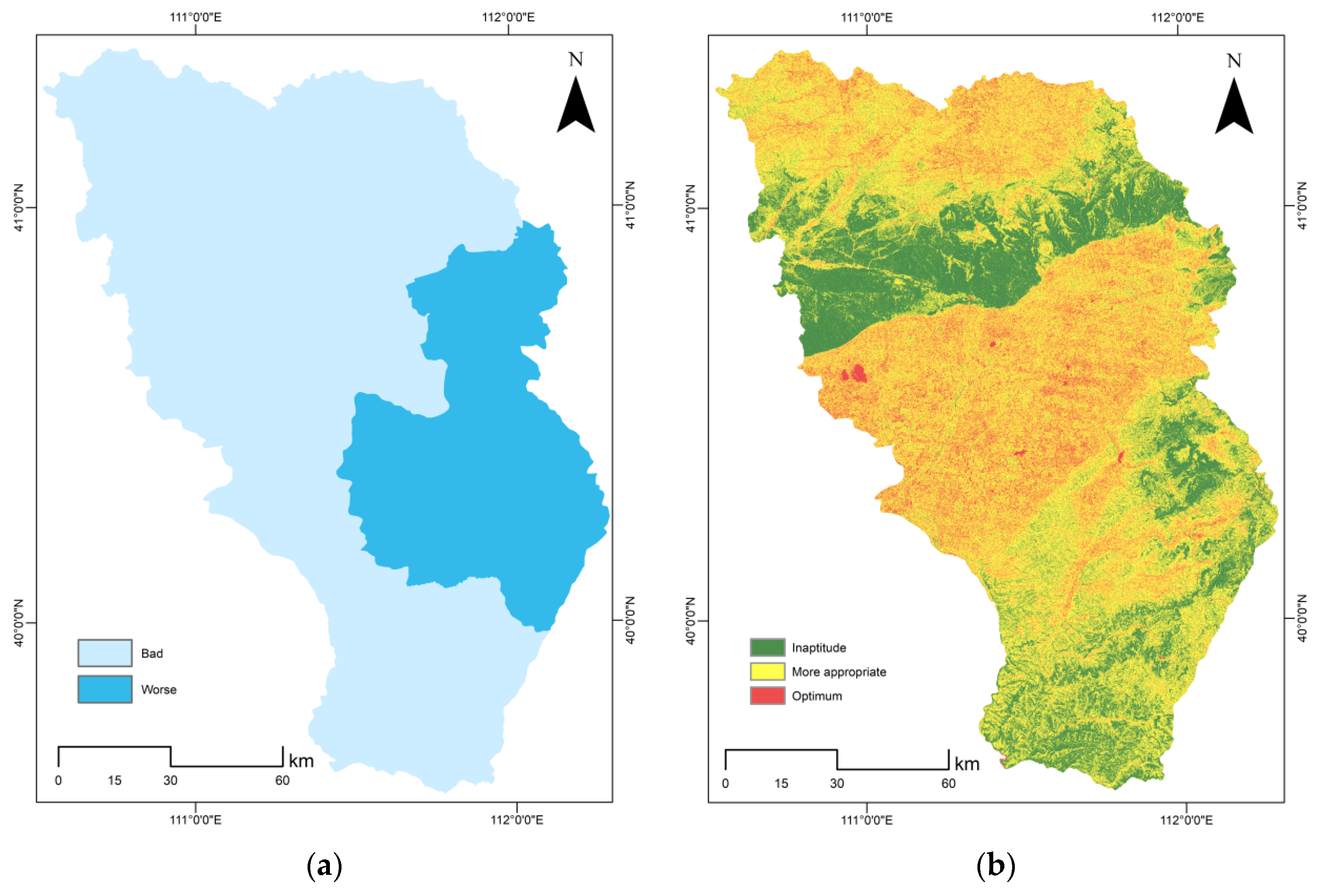
3.2. Space Development Suitability Evaluation

3.2.1. Suitability Evaluation of Agricultural Production

Integrative Assessment

Based on the single factor evaluation indexes of land resources, agricultural water supply conditions, light and heat conditions, and drought agricultural disasters that have been evaluated in the above-mentioned resource and environmental carrying capacity, the water and soil resource base under agricultural production conditions is determined according to the evaluation results of land resources and agricultural water supply conditions. Combined with the evaluation of light and heat conditions and drought agricultural disasters, the highest value of each item is used and the preliminary results of agricultural production suitability grade are obtained by using GIS mosaic tools. Then, the initial evaluation results are corrected, according to the actual situation in Hohhot. The initial evaluation results were of an appropriate level; thus, they were not amended.
In the agricultural production suitability evaluation based on the “double evaluation” strategy, the overall level is high, and the suitable area and the relatively suitable area account for more than half of the total area, which has good conditions for the development of agricultural production. The overall agricultural production suitability grade of Hohhot is not suitable (Figure 11). The climate environment is poor, the crop is mainly one crop per year, the water supply condition is general, the whole region is mainly semi-arid and semi-humid, the land resource environment is poor, and the land resource environment is mainly suitable. The terrain fluctuation and slope are large, and the shortage of water resources restricts agricultural development and is not suitable for agricultural production. In the future development, we should pay attention to the rational use of water resources and improve agricultural production.

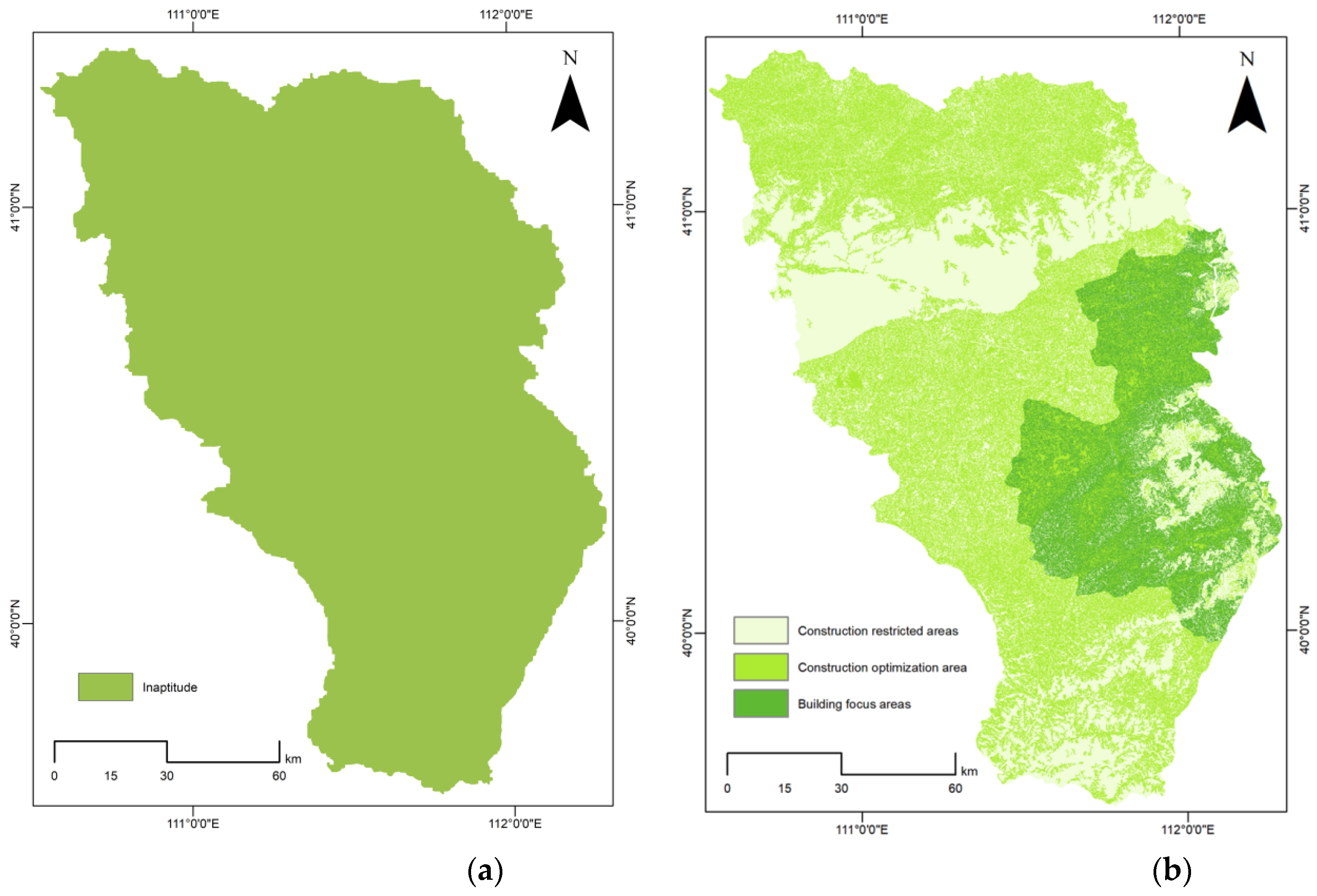
3.2.2. Suitability Evaluation of Urban Construction

Integrative Assessment

Based on the evaluation of land resources, urban water supply conditions, light and heat conditions, topographic conditions, and geological disaster risk factors that have been evaluated in the above-mentioned resource and environmental carrying capacity, the suitability of urban construction in Hohhot was evaluated and analyzed. Because the location conditions are dynamically changing, this integration did not consider the evaluation factors of location advantage. According to the land resources and urban water supply conditions, the basis of water and soil resources was determined. On the basis of the classification results, the first step was to modify the classification by intersecting it with the disaster risk, and the unsuitable plots were extracted separately. Using the aggregation surface command, the suitable plots and the more suitable plots of the modified results were aggregated, and the concentration degree was classified by using the area of each block. Using the intersection command, the aggregated plots and the basis of water and soil resources were intersected to obtain the first step of integrated evaluation and classification. According to the evaluation results of suitability, initial judgment grade, and plot concentration degree, the suitability grade of urban construction is determined according to the discriminant matrix and, finally, the combined command is used. The evaluation results are combined with unsuitable plots to obtain the suitability evaluation map of urban construction [46].
In the study of urban construction suitability evaluation under the background of land and space planning, the suitability level of urban construction is divided into construction optimization area, construction key area, and construction restriction area by the ArcGIS natural fracture method. It can be seen from the figure that the suitability of urban construction in Hohhot is general (Figure 11). The areas of unsuitable, more suitable, and most suitable grades accounted for about 40%, 45%, and 15%, respectively, and the proportion of unsuitable and more suitable grade was the highest. The two were concentrated in the north, west, and south, which were closely related to the land resources and terrain conditions in the region. The terrain undulation was large, the land resources were poor, and the climate change was large, which would affect the suitability of urban construction. The most suitable proportion is the smallest mainly distributed in the east. The region has good land resource conditions, flat terrain, and high comfort. The construction restriction area is mainly distributed in the urban space expansion area, the cultivated land surrounds the city (cultivated land by agriculture), the city is located in a Piedmont plain, the Piedmont plain is a good structure for groundwater storage (water resources protection), the urban development expansion area is located in the river flood discharge area (topographic and geological conditions), and the urban construction suitability of Hohhot is poor.

4. Discussion

China’s new land space planning system was only recently established. Under the social background of high-quality development and ecological civilization construction, it is necessary to evaluate the total factors of land space resources and environment before planning and determine the land space distribution characteristics, scope, and scale suitable for ecology, agriculture, and urban functions, so as to provide the basis for subsequent land space control and planning. The primary task of high-quality development in the new era is to practice the concept of green development and promote the reform of ecological civilization. The “Overall Plan for the Reform of Ecological Civilization System” proposes to promote green development and establish a land space development and protection system based on spatial planning with use control as the main means. Moreover, high-quality development is inseparable from regional synergy. Regional synergy emphasizes regional functional coordination and overall efficiency improvement. Regional functions should not pay too much attention to urban production and living functions, but pay more attention to the ecological functions of the natural environment. The development directions of the new era are high-quality development, green development, and coordinated development, requiring long-term vision and scientific and implementation requirements for the planning discipline. Operational engineering needs to be combined with qualitative and quantitative engineering. Since the optimization of land spatial pattern was first proposed in 2012, the road to establish a spatial planning system has become increasingly clear: national development must be gradually established a national development as the guide, based on spatial planning, and supported by special planning composed of national, provincial, municipal, and county planning. In January 2019, the Ministry of Natural Resources issued the “Guiding Opinions on Doing a Good Job in Realizing the Public Compilation of Territorial Space Master Plan”, which clarified the status of dual evaluation of territorial space planning. Territorial space planning should be based on “dual evaluation”. After determining the zoning and access rules of territorial space planning in the whole region, the “three lines” are delineated. Dual evaluation is the basic preparation before the compilation of territorial space planning.
At present, the research on double evaluation is mostly carried out on a large (province) scale; research on the country scale is less frequently executed. In a study of the double evaluation of land space at the city and county level supported by multisource data, Xiongyuan selected data, such as ecosystem, spatial distribution, DEM data, average annual precipitation, light and temperature production, etc., with biological richness, water conservation function, light and temperature production potential, surface slope, elevation, etc., as evaluation indicators, and carried out ecological protection evaluation, agricultural function carrying capacity evaluation, and urban function carrying capacity evaluation. The single factor integration method and discriminant matrix method were used to evaluate the carrying capacity of resources and environment and the suitability of land and space development. The proportion was calculated and the double evaluation of Huayuan County was analyzed. Zhang Zhirong takes the county as an example in the study of “double evaluation” of county-level land and space planning. Based on the guidelines, the evaluation scope was determined, the index system was constructed, and the development suitability was evaluated by using the limit condition method and the comprehensive index method. The carrying capacity of resources and environment evaluates the maximum scale of single-factor carrying agricultural production and urban construction and uses the minimum value as the upper limit. In a study of the support mode of “double evaluation” in territorial spatial planning, Xie Linglin took Fenghuang County as an example. Based on the guidelines, basic data, planning results data, laws, and regulations, policy data were selected to evaluate the current situation of ecological resources, land resources, and water resources in Fenghuang County, so as to provide support for territorial spatial planning. This paper mainly uses the GIS spatial analysis function to select evaluation factors such as water resources, land resources, climate, meteorology, environment, ecological conditions, topography and location in Hohhot, and evaluates them from three perspectives: ecological protection, agriculture, and town [47], calculates the proportion of each evaluation in Hohhot, and analyzes the evaluation results of Hohhot. The indicators selected in this paper are more comprehensive, so they can be more convincing. A comprehensive analysis of the current situation of resource and environmental utilization and the suitability of land space development in Hohhot shows that the ecological protection function, agricultural function carrying capacity, and urban function carrying capacity of Hohhot are better, agricultural production is not suitable, and urban construction suitability is general. Zhang Zhirong found in a “double evaluation” analysis of Chengcheng County that the importance of ecological protection in Chengcheng County was general, the ecological background was generally good, and the vulnerability of local areas was high. The suitability of agricultural production was generally high, and the unsuitable area only accounted for 7.1%. A low suitability of urban construction was found. Through the analysis of the carrying capacity of resources and environment, it was found that the main resource and environment constraints are water and land resources. In an analysis of the carrying capacity of resources and environment in Ganzhou City, with the support of GIS, Wang Xuejun selected 12 index factors, such as land use, resource environment ecological environment, topography, social economy, etc., for statistical analysis. It was found that the carrying capacity of resources and environment in Ganzhou City is not optimized, and the economic development space is small. We expound on the problems existing in the carrying capacity of resources and environment and the suitability of land space development in Hohhot, analyze the reasons, summarize the conclusions, and analyze the land space of Hohhot and prospects. In terms of research accuracy, the accuracy of geographic data in this study is not high and the data were not easy to obtain, resulting in insufficient accuracy of some layers and indicators. In a follow-up study, more accurate data should be obtained for more accurate and rigorous analysis. In the selection of evaluation indicators, this paper, due to limited access, was not adequately comprehensive, resulting in the lack of specific evaluation. In a follow-up study, more representative evaluation indicators should be selected for more comprehensive analysis. In future research, we should improve efficiency, clarify research objectives, coordinate conflicts on the basis of adhering to the ecological red line, and establish a more perfect land and spatial planning system to provide promises and guarantees for ecological restoration and land consolidation [48].
Therefore, in future research and study, on the basis of adhering to the red line of ecological protection, we will continue to strengthen ecological protection and construction; improve water conservation and soil and water conservation capacity; maintain or reconstruct forests, grasslands, and other ecosystems; strengthen small watershed management and afforestation; limit steep slope reclamation and overgrazing; and increase mine environmental remediation and restoration efforts [49]. The goal is to expand the area in the city, improve the ability to maintain biodiversity, strengthen the construction of nature reserves, prevent the destruction of important species’ habitats and their natural ecosystems, enhance the carrying capacity of agricultural and urban functions, cherish water resources, protect groundwater, ensure that suitable crops are planted according to the terrain and geological conditions, and ensure that urban expansion areas are developed according to local conditions. Land that is not suitable for development should be renovated to reduce harm, and ecological space or suitable development spaces should be repaired, increasing the overall available space and reducing the risk to the surrounding area [50].

5. Conclusions

Taking Hohhot as the research object, this paper evaluated the carrying capacity of resources and environment and the suitability of land and space development from three aspects: ecological protection, agriculture, and urban. The conclusions are as follows:
The ecological protection function is high. Low-level areas are mainly scattered in the north and central regions, accounting for about 18% of the total; intermediate areas are mainly in the north and south, accounting for about 62%; advanced areas are mainly sporadically distributed in the south; and there are a small number of areas in the central region, accounting for about 21%.
The bearing capacity of agricultural function is high. Low-grade areas are scattered in the north and south, and a small number of these are found in the central part, accounting for about 23% of the total; the intermediate-grade areas account for the greatest amount, about 71%; and the advanced-level areas are mainly concentrated in the middle, accounting for about 6%.
Urban functional carrying capacity is moderate. Low-level areas are mainly distributed in the north, south, and, sporadically, in the east accounting for about 25% of the total; the intermediate-level areas are mainly distributed in the north and middle, accounting for about 55%; and the advanced-level areas are mainly distributed in the east, accounting for about 21%.
The evaluation grade of agricultural production suitability is classified as unsuitable. The climate of the whole study area is semi-arid and semi-humid, with general water supply conditions and large topographic relief, which is not suitable for agricultural production.
The suitability of urban construction is moderate. Unsuitable areas are mainly distributed in the north, south, and, sporadically, in the east, accounting for about 40% of the total; more suitable areas are distributed throughout the study area, accounting for about 45%; and the most suitable areas are mainly distributed in the east, accounting for about 15%.
Therefore, we found that the carrying capacity of resources and environment in Hohhot is moderate, and the main proportion factor is agriculture; the suitability of land space development is general, and the main environmental constraint is water and soil resources, which limits the development of towns.

6. Prospects

As the bases of territorial space planning, important roles are played by the carrying capacity of resources and environment and the suitability of territorial space development. Through the study of Hohhot, we determined that there are still some deficiencies in the research on these subjects [51]. Further research on decision-making systems and implementation is needed in the future. The evaluation in the “Guide” is applicable on the national level and is not universal [52]. In the future, the content of the guide should be improved and enriched, so as to help control the scale of urban development within a reasonable range. Secondly, a feedback mechanism should be constructed. The focus of the work of the higher level cities should be coordinated with the lower level towns to better understand the significance of “double evaluation” [53]. Finally, governments at all levels should raise awareness of protection, understand the importance of ecological construction and sustainable development, clarify that “double evaluation” is the basis of territorial spatial planning, reduce the harm of urban development to the environment, and renovate and repair unsuitable land. Therefore, in the long run, coordinating the development and utilization of resources by the development of human society is not only the key point to promote sustainable development but also an important strategy to promote the sustainable, stable, and healthy construction of ecological civilization [54].

Author Contributions

G.C. proposed the topic of the paper, provided research methods and data sources, guided the research of the paper, put forward suggestions and modifications in the process of analysis and interpretation, and edited the paper. S.W. analyzed the data drafted the paper, and processed and analyzed the evaluation charts. All authors have read and agreed to the published version of the manuscript.

Funding

This research received no external funding.

Institutional Review Board Statement

This study was approved by the regional Ethics Committee of our hospital, and all researchers signed informed consent.

Informed Consent Statement

All authors are informed.

Data Availability Statement

The authors confirm that the data supporting the findings of this study are available within the article.

Conflicts of Interest

The authors declare no conflict of interest.

References

  1. Tang, C.H.; Fan, J.; Sun, W. Distribution characteristics and policy implications of territorial development suitability of the Yangtze River Basin. J. Geogr. Soc. China 2015, 25, 16. [Google Scholar] [CrossRef]
  2. Zhao, G.; Liang, R.; Li, K. Study on the coupling model of urbanization and water environment with basin as a unit: A study on the Hanjiang Basin in China. Ecol. Indic. 2021, 131, 108130. [Google Scholar] [CrossRef]
  3. Guo, K.; Zhang, X.; Liu, J. Establishment of an integrated decision-making method for planning the ecological restoration of terrestrial ecosystems. Sci. Total Environ. 2020, 741, 139852. [Google Scholar] [CrossRef] [PubMed]
  4. Jafari, S.; Zaredar, N. Development, Land Suitability Analysis using Multi Attribute Decision Making Approach. Int. J. Environ. Sci. Dev. 2010, 1, 441–445. [Google Scholar] [CrossRef]
  5. He, Y.D.; Wang, L.F.; Zhai, Y.B. Analysis on Environmental Carrying Capacity of Chang-Zhu-Tan City Group. Environ. Sci. Technol. 2010, 33, 401–404. [Google Scholar]
  6. Wang, Y.; Su, X.; Qi, L.; Liu, M. Evaluation of the Comprehensive Carrying Capacity of Interprovincial Water Resources in China and the Spatial Effect. J. Hydrol. 2019, 575. [Google Scholar] [CrossRef]
  7. Davidson, D.A.; Theocharopoulos, S.P. A land evaluation project in Greece using GIS and based on Boolean and fuzzy set methodologies. Int. J. Geogr. Inf. Syst. 1994, 8, 369–384. [Google Scholar] [CrossRef]
  8. Tian, H.L.; Qiao, J.P.; Zhu, B. Rapid evaluation of resources and environment carrying capacity in Chengdu disaster area based on GIS technology. Sichuan Univ. Nat. Sci. Ed. 2009, 41, 45–48. [Google Scholar]
  9. Wu, B. Evaluation of carrying capacity of resources and environment in Shenzhen based on principal component analysis. In Proceedings of the 2010 China Sustainable Development Forum, Jinan, China, 22 October 2010. [Google Scholar]
  10. Gao, R.Z.; Li, H.P.; Tong, C.F. Comprehensive evaluation and analysis of water resources carrying capacity in Ordos City. Soil Water Conserv. 2011, 18, 5. [Google Scholar]
  11. Wang, X.J.; Fu, X.; Sun, Y.J. Evaluation of carrying capacity of resources and environment in Ganzhou City based on GIS. J. Jiangxi Agric. Univ. 2013, 35, 8. [Google Scholar]
  12. Shao, Y.P.; Guo, Z.Y.; Bai, S.J. Resources, Evaluation of Resources and Environment Carrying Capacity and Optimization of Spatial Layout Based on GIS—Setting Rongcheng City as an Example. Shandong Land Resour. 2019, 35, 57–61. [Google Scholar]
  13. Liang, T.; Cai, C.X.; Liu, M. Study on methodology of ecological suitability assessment of urban landuse: An example of Pingxiang. Geogr. Study 2007, 26, 782–788. [Google Scholar]
  14. Tang, C.C.; Sun, W. Comprehensive evaluation of land spatial development suitability of the Yangtze River Basin. J. Geogr. Soc. China 2012, 67, 1587–1598. [Google Scholar]
  15. Huang, S.J.; Meng, X.B. Ecological suitability evaluation of Shishou City in Hubei Province based on GIS technology. Intell. Build. City Inf. 2021, 7, 34–35. [Google Scholar]
  16. Lee, D.; Oh, K. A Development Density Allocation Model based on Environmental Carrying Capacity. Int. J. Environ. Sci. Dev. 2012, 3, 486–490. [Google Scholar] [CrossRef]
  17. Xu, H.; Li, X.; Li, L. Evaluation of urban subsurface space development suitability in the city of Qingdao. In Proceedings of the 2010 The 2nd Conference on Environmental Science and Information Application Technology, Wuhan, China, 17–18 July 2010. [Google Scholar]
  18. Zheng, Y.; Li, R.R. Evaluation of Resource and Environment Carrying Capacity—Taking Si County of Anhui Province as an Example. Hit J. 2019, 28, 56–60. [Google Scholar]
  19. Zhang, B.W. Environmental landform and urban construction in Hohhot. J. Arid. Land Resour. Environ. 1993, 1, 9. [Google Scholar]
  20. Qin, Z. Analysis of climate change characteristics in Hohhot from 1988 to 2017. Mod. Agric. Sci. Technol. 2019, 2, 1. [Google Scholar]
  21. Qu, Y.; Zhang, F.; Jiang, G.; Guan, X.; Guo, L. Suitability evaluation and subarea control and regulation of rural residential land based on niche. Trans. Chin. Soc. Agric. Eng. 2010, 26, 290–296. [Google Scholar]
  22. Feng, Z.M.; Yang, Y.Z.; Yan, H.M.; Tao, P.; Peng, L. Research on the carrying capacity of resources and environment in the past century:from theory to practice. Resour. Sci. 2017, 39, 379–395. [Google Scholar]
  23. Li, M.; Liang, D.; Xia, J.; Song, J.; Cheng, D.; Wu, J.; Cao, Y.; Sun, H.; Li, Q. Evaluation of water conservation function of Danjiang River Basin in Qinling Mountains, China based on InVEST model. J. Environ. Manag. 2021, 286, 112212. [Google Scholar] [CrossRef] [PubMed]
  24. Akalu, T.; Jan, D.G.; Leo, S. Evaluation of soil and water conservation practices in the north-western Ethiopian highlands using multi-criteria analysis. Front. Environ. Sci. 2014, 2, 60. [Google Scholar]
  25. Manguin, S.; Boëte, C. The Importance of Biological Interactions in the Study of Biodiversity; BoD–Books on Demand: Norderstedt, Germany, 2011. [Google Scholar]
  26. Pandey, S.; Kumar, P.; Zlatic, M.; Nautiyal, R.; Panwar, V.P. Recent advances in assessment of soil erosion vulnerability in a watershed. Int. Soil Water Conserv. Res. 2021, 9, 305–318. [Google Scholar] [CrossRef]
  27. Marin, C.M.; Smith, M.G. Water-resources assessment—A spatial equilibrium approach. Water Resoures 1988, 24, 793–801. [Google Scholar] [CrossRef]
  28. Bhermana, A.; Sunarminto, B.H.; Utami, S.; Gunawan, T. The combination of land resource evaluation approach and gis application to determine prime commodities for agricultural land use planning at developed area (a case study of Central Kalimantan province, Indonesia). J. Agric. Biol. Sci. 2013, 8, 771–784. [Google Scholar]
  29. Oh, K.; Jeong, Y.; Lee, D.; Lee, W.; Choi, J. Determining development density using the Urban Carrying Capacity Assessment System. Landsc. Urban Plan. 2005, 73, 1–15. [Google Scholar] [CrossRef]
  30. Wang, D.H.; Li, X.D. Analysis of Resources and Environmental Carrying Capacity and Regional Coordinated Development in Mountainous Watershed: A Case Study of Wujiang River Basin in Guizhou. Environ. Sci. Technol. 2019, 43, 222–229. [Google Scholar]
  31. Liu, T.K.; Yuan, C.F. Thoughts on the importance evaluation of water conservation function based on GIS-Taking the Yellow River Basin in Henan Province as an example. Reg. Gov. 2020, 4, 3. [Google Scholar]
  32. Jiao, X.L. Study on the importance of soil and water conservation function based on ‘double evaluation’ of land and space planning-Taking Lingchuan County as an example. Nat. Resour. North China 2022, 1, 154–156. [Google Scholar]
  33. Xu, K.; Kong, C.; Li, J.; Zhang, L.; Wu, C. Suitability evaluation of urban construction land based on geo-environmental factors of Hangzhou, China. Comput. Geosci. 2011, 37, 992–1002. [Google Scholar] [CrossRef]
  34. Lei, Y. Evaluation of the importance of soil and water conservation function in Fujian Province based on GIS. Bull. Soil Water Conserv. 2020, 40, 7. [Google Scholar]
  35. Liu, T.K.; Xiao, J.C. Importance evaluation of biodiversity conservation function in the Yellow River Basin of Henan Province based on net primary productivity. Henan Sci. Technol. 2020, 16, 3. [Google Scholar]
  36. Du, H.E.; Li, Z.; Zheng, Y. Research progress on resource and environment carrying capacity evaluation and land space development suitability evaluation. Chin. Min. 2019, 28, 7. [Google Scholar]
  37. Zhong, Z.Q. Forestland Ecological Vulnerability Evaluation in Shunchang County, Fujian Province. J. Beihua Univ. 2017, 18, 395–400. [Google Scholar]
  38. Fang, Y.S.; Zu, J.; Ai, D.; Jie, C.; Qiuyue, L. Evaluation of the importance of ecological protection in Kunming for territorial spatial planning. J. China Agric. Univ. 2021, 26, 152–163. [Google Scholar]
  39. Wang, T.Y. Suitability evaluation of land space development and construction-Taking Fuxian County of Yan’an City as an example. Agric. Technol. 2021, 41, 8. [Google Scholar]
  40. Xu, Y.Y.; Yu, Y.; Li, C.; Juan, F. Agricultural production suitability evaluation based on ‘double evaluation’ strategy. J. Tonghua Teach. Coll. 2021, 42, 25–31. [Google Scholar]
  41. Li, Y.; Wang, Y.L.; Peng, J.; Chang, Q.; Zong, Z.; Liu, X. Assessment of urban land suitability for construction in view of landscape ecology: A case study of Dandong City. Acta Ecol. Sin. 2010, 30, 2141–2150. [Google Scholar]
  42. Yin, X.G.; Mi, H.Y.; Wang, B. Evaluation of provincial land resources under the ‘double evaluation’ method-Taking Yunnan Province as an example. Software 2020, 41, 6. [Google Scholar]
  43. Wu, S.Z.; Yan, Z.R.; Ma, J.; Xu, M.; Fan, Y.; Wang, J. Assessment on Terrain Conditions of Cultivated Land Based on DEM in Xingcheng City, Liaoning Province. Bull. Soil Water Conserv. 2018, 38, 195–199+205. [Google Scholar]
  44. Wang, S.; Mao, H.; Zhao, M. Thinking on the index system design to the land comprehensive carrying capacity—A case study: Coastal region of China. J. Nat. Resour. 2001, 3, 248–254. [Google Scholar]
  45. Duan, S.R.; Li, Y.F.; Li, C.Y. Risk assessment of geological disasters in Gande County of Qinghai Province based on GIS and analytic hierarchy process. Miner. Explor. 2021, 2, 012. [Google Scholar]
  46. Yue, W.Z.; Wang, T.Y. Logical issues of resource and environmental carrying capacity evaluation and land spatial planning. Land Sci. China 2019, 33, 8. [Google Scholar]
  47. Martire, S.; Castellani, V.; Sala, S. Methodology for Sustainability Assessment and Resource Efficiency in Forest Sector. In Proceedings of the SDEWES Conference, Ohrid, North Macedonia, 1–7 July 2012. [Google Scholar]
  48. Lu, H.J. Exploration and Research on Territorial Space Planning from the Perspective of Ecological Civilization—Taking Yong’an Town, Chengdu as an Example. J. Nat. Resour. 2021, 8, 1–8. [Google Scholar] [CrossRef]
  49. Reid, W.V.; Chen, D.; Goldfarb, L.; Hackmann, H.; Lee, Y.T.; Mokhele, K.; Ostrom, E.; Raivio, K.; Rockström, J.; Schellnhuber, H.J.; et al. Earth System Science for Global Sustainability: Grand Challenges. Science 2010, 330, 916–917. [Google Scholar] [CrossRef] [Green Version]
  50. Rees, W.E. Urbanization, Ecological Footprints and Appropriated Carrying Capacity: What Urban Economics Leaves Out. Environ. Urban. 1992, 4, 121–130. [Google Scholar] [CrossRef]
  51. Higgins, G.M.; Kassam, A.H.; Naiken, L.; FAO; International Institute for Applied Systems Analysis. Potential Population Supporting Capacities of Lands in the Developing World. In Readings in Population Research Methodology; UN: Rome, Italy, 1993. [Google Scholar]
  52. He, B.; Chen, A.; Jiang, W.; Chen, Z. The response of vegetation growth to shifts in trend of temperature in China. J. Geogr. Sci. 2017, 27, 16. [Google Scholar] [CrossRef] [Green Version]
  53. Graymore, M.L.M.; Sipe, N.G.; Rickson, R.E. Sustaining Human Carrying Capacity: A tool for regional sustainability assessment. Ecol. Econ. 2010, 69, 459–468. [Google Scholar] [CrossRef]
  54. Ding, Y.C. Research on ‘Double Evaluation’ Method in County-Level Territorial Spatial Planning; North West China University: Xi’an, China, 2021. [Google Scholar]
Figure 1. Geographic map of the study area.
Sustainability 15 12411 g001
Figure 2. Technology roadmap.
Sustainability 15 12411 g002
Figure 3. Importance evaluation map of water conservation function (a) and soil and water conservation function in the city of Hohhot (b).
Sustainability 15 12411 g003
Figure 4. Importance evaluation map of ecosystem type (a) and biodiversity maintenance function in Hohhot (b).
Sustainability 15 12411 g004
Figure 5. Evaluation diagram of ecological vulnerability (a) and ecological system integration in Hohhot (b).
Sustainability 15 12411 g005
Figure 6. Evaluation of photothermal conditions (a) and agricultural water supply conditions in Hohhot (b).
Sustainability 15 12411 g006
Figure 7. Evaluation of land resources (a) and drought agricultural disasters in Hohhot (b).
Sustainability 15 12411 g007
Figure 8. Evaluation map of vegetation cover (a) and agricultural function carrying capacity in Hohhot (b).
Sustainability 15 12411 g008
Figure 9. Evaluation map of urban water supply (a) and terrain conditions in Hohhot (b).
Sustainability 15 12411 g009
Figure 10. Evaluation map of geological disasters (a) and urban functional carrying capacity in Hohhot (b).
Sustainability 15 12411 g010
Figure 11. Evaluation map of suitability of agricultural production (a) and urban construction in Hohhot (b).
Sustainability 15 12411 g011
Table 1. Table of evaluation indexes for carrying capacity of resources and environment in Hohhot.
Evaluation DimensionEvaluation ContentEvaluating IndicatorMethod of Calculation
Ecological protection evaluationEcosystem servicesWater conservation function w a t e r   c o n s e r v a t i o n   ( T Q ) = Σ i j ( P i R i E T i ) × A i × 10 3 [23]
Soil and water conservation function s o i l   a n d   w a t e r   c o n s e r v a t i o n ( A ) = R × K × L × S × ( 1 C ) [24]
Biodiversity Biodiversity   maintenance   service   capability   index ( S bio ) = NPP mean × F pre × F tem × ( 1 F alt ) [25]
Ecological sensitivitySoil erosion sensitivity [ V u l n e r a b i l i t y   o f   s o i l   e r o s i o n ] = R × K × L S × C 4 [26]
Evaluation of agricultural function carrying capacityLight and heat conditionsLight and heat conditions [ l i g h t   a n d   h e a t   c o n d i t i o n s ] = f ( A c c u m u l a t e d   t e m p e r a t u r e   i n t e r p o l a t i o n )
Foundation of water and land resourcesAgricultural water supply conditions [   r i c h n e s s   o f   w a t e r   r e s o u r c e ] = f ( [ p r e c i p i t a t i o n ] ,   [ w a t e r   a v a i l a b i l i t y ] ) [27]
Land resources [ A g r i c u l t u r a l   f a r m i n g   c o n d i t i o n s ] = f ( [ g r a d i e n t ] ,   [ e l e v a t i o n ] ) [28]
Environmental capacity of soilDrought agricultural disasters [ D r o u g h t   a g r i c u l t u r a l   d i s a s t e r s ] = f ( G r i d   i n t e r p o l a t i o n )
Evaluation of urban functional carrying capacityFoundation of water and land resourcesUrban water supply conditions [ r i c h n e s s   o f   w a t e r   r e s o u r c e ] = f ( [ p r e c i p i t a t i o n ] ,   [ w a t e r   a v a i l a b i l i t y ] )
Topographic condition [ t o p o g r a p h i c   c o n d i t i o n ] = ( M u l t i f a c t o r   c o m p r e h e n s i v e   w e i g h t i n g )
Disaster potentialGeological hazard risk [ g e o l o g i c a l   h a z a r d   r i s k ] = f ( g e o r e f e r e n c e )
Table 2. Evaluation table of suitability index for land space development in Hohhot.
Evaluation DimensionEvaluation ContentEvaluating IndicatorMethod of Calculation
Agricultural production suitabilitySingle factor of agricultural production suitabilityLand resources [ A g r i c u l t u r a l   f a r m i n g   c o n d i t i o n s ] = f ( [ g r a d i e n t ] ,   [ e l e v a t i o n ] )
Agricultural water supply conditions [ r i c h n e s s   o f   w a t e r   r e s o u r c e ] = f ( [ p r e c i p i t a t i o n ] ,   [ a v a i l a b l e   w a t e r   r e s o u r c e s ] )
Light and heat conditions [ l i g h t   a n d   h e a t   c o n d i t i o n s ] = f ( A c c u m u l a t e d   t e m p e r a t u r e   i n t e r p o l a t i o n )
Drought agricultural disasters [ D r o u g h t   a g r i c u l t u r a l   d i s a s t e r s ] = f ( G r i d   i n t e r p o l a t i o n )
Integrated evaluation
Suitability of urban constructionSingle factor of urban construction suitabilityTopographic condition [ t o p o g r a p h i c   c o n d i t i o n ] = ( M u l t i f a c t o r   c o m p r e h e n s i v e   w e i g h t i n g )
Water supply condition [ r i c h n e s s   o f   w a t e r   r e s o u r c e ] = f ( [ p r e c i p i t a t i o n ] ,   [ a v a i l a b l e   w a t e r   r e s o u r c e s ] )
Geological hazard risk [ g e o l o g i c a l   h a z a r d   r i s k ] = f ( g e o r e f e r e n c e )
Table 3. Soil erosion sensitivity evaluation factor grading assignment table.
Evaluation FactorsHypersensitivityHigher SensitivityMid-SensitiveLow SensitivityLower Sensitivity
Rainfall erosivity>600400–600100–40025–100<25
Soil erodibilitySandy silt/silty soilSandy loam/silty clay/loamy claySurface sand/loam soilCoarse sand/fine sandy soil/clayGravel/sand
Topographic relief>300100–30050–10020–500–20
Vegetation cover≤0.20.2–0.40.4–0.60.6–0.8≥0.8
Classification97531
Disclaimer/Publisher’s Note: The statements, opinions and data contained in all publications are solely those of the individual author(s) and contributor(s) and not of MDPI and/or the editor(s). MDPI and/or the editor(s) disclaim responsibility for any injury to people or property resulting from any ideas, methods, instructions or products referred to in the content.

