Article

Study on the Spatial and Temporal Distribution of the High–Quality Development of Urbanization and Water Resource Coupling in the Yellow River Basin

1
College of Agricultural Science and Engineering, Hohai University, Nanjing 211100, China
2
College of Water Conservancy, North China University of Water Resources and Electric Power, Zhengzhou 450046, China
3
College of Liberal Arts & Sciences, University of Illinois Urbana–Champaign, Urbana, IL 60629, USA
*
Author to whom correspondence should be addressed.
Sustainability 2023, 15(16), 12270; https://doi.org/10.3390/su151612270
Submission received: 12 June 2023 / Revised: 22 July 2023 / Accepted: 3 August 2023 / Published: 11 August 2023

Abstract

:
China is facing a critical period of high–speed development and a transition to high–quality development. The purpose of this study is to investigate the spatial and temporal distribution of the coupling and coordination of high–quality development of urbanization and water resources in the Yellow River Basin (YRB). Firstly, we propose the concept of “High–Quality Development of Urbanization–Water Resources Coupling” and construct a high–quality development of urbanization (HQDU) system consisting of five sub–systems: innovation, coordination, greenness, openness and sharing, and a water resources system (WRS) consisting of four sub–systems: water resources background conditions, utilization capacity, management level, and pollution control. The improved coupling coordination degree model combined with the barrier degree model and clustering model is used to study the spatial and temporal distribution of the two systems in the YRB. The results show that the coupling coordination state of HQDU and WRS in the YRB improves to some extent, from “mild imbalance” to “barely coordination” in general; Henan and Ningxia are characterized by “low and fluctuating (levels) in early years and fast development in recent years”; Shanxi and Inner Mongolia develop steadily during the study period; Sichuan, Shandong, Shaanxi, and Qinghai are characterized by “low (levels) which lasted for a long time in the early stage and accelerated development in the later stage”; and Gansu Province is characterized by “high level in the early stage but insufficient momentum in later stage”. The Coordination Index of Urbanization Economic Growth Speed and the Total Wastewater Discharge are the most important obstacle factors in HQDU and WRS. This study explores the level of coordination development of HQDU and WRS as well as finds the obstacle factors in the development process of the two systems, which is an important reference value for the high–quality development of urbanization under the constraint of water resources.

1. Introduction

Water is a natural resource that ensures the survival of mankind and is an important basis for sustaining human social development. Ensuring that water resources are in good condition is of vital importance for the socio–economic development of mankind, as it can provide a good service to mankind. This is why water resources and related issues have become a major concern for scholars worldwide.
Urbanization is a natural historical process that comes along with industrialization, in which non–agricultural industries agglomerate and the rural population congregates in cities and towns. Since the implementation of China’s reform and opening–up policy in the 1970s, China’s urbanization level has developed rapidly. China’s urbanization rate has steadily increased, and as of 2019, it exceeded 60%. According to the international standard regarding the population urbanization rate of no less than 60%, China has realized urbanization and has initially completed the transition from a rural society to an urban society, entering the era of urban society [1]. At present, in order to meet the growing needs of the Chinese people for a better life, it is an inevitable trend for the development of China’s urbanization to transform into high–quality development. In 2018, the strategy of high–quality development of new urbanization was proposed, marked by the fact that China would start to solve environmental problems, resource allocation imbalance, and low–quality development problems in the early urbanization process. How to strengthen the high–quality development of urbanization has become a hot issue of national concern.
The high–quality development of urbanization (HQDU) in China is the inevitable result of following history and policies. HQDU and water resources systems (WRSs) are interdependent and mutually supportive, and WRS is a prerequisite for HQDU. However, China has a history of water scarcity and uneven distribution, and water problems are a serious constraint on economic development, people’s lives, and HQDU. At the end of 2020, China’s per capita water resources were only 2239.8 m3, only about 1/4 of the world average, which is at a backward level in the world. The Yellow River Basin (YRB) has an important strategic position in China, and it is also an important economic center, ecological barrier, and an important area for the implementation of the rural revitalization strategy in China. However, the level of development and development heritage within the YRB are relatively low, and the total water resources, economic development level, and development speed are in a relatively backward position in China. Therefore, the YRB will be a key region for China’s future high–quality development. The current vigorous development of urbanization in China has brought increasing pressure on regional water resources. In 2019, China proposed water resources as the biggest constraint for urban, land, population, and industrial development.
Water shortage is an important constraint in the development of the Yellow River Basin. Human activities and climate change have led to a steady decline in water resources, further exacerbating the problem of water scarcity. The transition from urbanization to a high–quality development stage is also restricted by the shortage of water resources. Therefore, given the contradiction between the transition from urbanization to high–quality development in the YRB and the current water shortage, how to manage the coordinated development of the two will become the focus of attention in the future.
The coupling coordination degree (CCD) model is a method to analyze the interaction and influence among multiple systems, which is widely used to study the coordination among different systems. The CCD model can measure the comprehensive values that show the incompatibility or contradiction with water resources in the process of HQDU. This paper proposes the theory of “High–Quality Development of Urbanization–Water Resources Coupling”, constructs two index systems of HQDU and WRS from a theoretical perspective, evaluates the comprehensive development index, and measures the CCD. Finally, the obstacle model is applied to identify the obstacle factors.
The research objective of this paper is to explore the coordination relationship between HQDU and WRS in the Yellow River Basin by coupling the coordination degree model, obstacle degree model, and clustering model. This analyzes the spatial and temporal distribution status and obstacle factors of HQDU and WRS in the Yellow River Basin, and provides certain references for the benign and coordinated development of HQDU and WRS, as well as for the formulation of regional macro policies.

2. Literature Review

2.1. Urbanization and High–Quality Development of Urbanization

Urbanization is the inevitable choice of historical development and a symbol of social development. With the comprehensive construction of urbanization, its development level to a certain extent reflects the comprehensive national power [2]. Since urbanization was first proposed, many scholars have conducted corresponding studies in this field. In terms of the significance of urbanization, Bloom, Canning, and Fink [2] believe that urbanization plays an important role in supporting economic growth. Michaels et al. [3] argue that with the development of urbanization, various factors of production in society will shift toward the service industry and the focus of social development will be tilted toward the service industry; Kolko [4] argues that the focus of urbanization is to expand the size of cities. After satisfying the needs of the speed and scale of urbanization development, many problems brought by rapid urban development began to receive people’s attention, and then, the issue of the quality of urbanization development began to be paid attention to. Turok and McGranahan [5] argue that after the massive expansion of urban areas, the focus should be on improving the quality of life and production of urban residents, increasing investments in social services and infrastructure. In exploring the intrinsic correlates of urbanization, Mcgranahan et al. [6] found that economic and environmental factors can seriously affect the level and quality of urbanization development. Since then, people have been exploring the development level and quality of urbanization from several perspectives. Gu et al. [7] reviewed the process of China’s urbanization between 1949 and 2015, and they argue that contemporary China’s urbanization has experienced four stages: (1) economic re–construction and industrialization–led urbanization (1949–1977); (2) economic reform and market–led urbanization (1978–1995); (3) economic globalization and global–local urbanization (1996–2010); and (4) land–economy–led urbanization (2010–2015); Chen et al. [8] argued that China’s urbanization has gone through three stages: the rapid decline stage (1960–1978), the stable stage of ascension (1979–1995), and the rapid promotion stage (1996–2010). Chu et al. [9] constructed a system of indicators of the level of urbanization development from four aspects: population, economy, society, and ecology, and measured the level of urbanization coordination in Russia by using the coupling coordination degree model and ArcGIS software; Zhou et al. [10] proposed a four–quadrant urbanization bubble assessment system consisting of the urbanization rate deviation from the proportion of the urban population with registration (TRP), urban construction land area (TBA), level of industrial development (LID), and level of public facilities (LPFs).

2.2. The Relationship between Urbanization and Water Resources

Urbanization is an inevitable trend that human beings need to go through to pursue a high quality of life. Every aspect of urbanization development cannot be separated from water resources, which are needed for living, production, and ecological protection. There is a profound relationship between urbanization and water resources, which has been discussed by scholars in the field in recent years. In terms of water resource constraints on urbanization, Wang and Gao [11] explored the intensity of water resource constraints (WRCI) to urbanization for each year in Wuwei and Jinchang counties through an integrated econometric model. Another group of scholars tried to investigate the impact of urbanization on water resources from the exact opposite direction. Avazdahandeh and Khalilian [12] investigated the impact of urbanization on agricultural water use in Qazvin Province using mathematical planning methods. Mu et al. [13] explored the spatial impact of urbanization on water use and its driving mechanisms using a spatial panel econometric model based on data from 2005 to 2017 from a water ecological footprint perspective. In addition, a number of scholars have also made efforts to explore the relationship between water security [14], urban water use [15], and water ecology [16] and urbanization.

2.3. Summary

To summarize, in recent years, international scholars have been fruitful in addressing urbanization, the high–quality development of urbanization, and the relationship between the two and water resources. Urbanization and HQDU have remarkable results from the meaning of urbanization to the direction and trend of urban development and to the measurement of development level and evaluation of development quality. In the field of water resources, scholars’ main research areas focus on water constraints on urban development and the impact of urbanization on water resources. In addition, water ecology, water security, and water resource utilization are also important research directions. Under the trend of urbanization transforming from high–speed development to high–quality development, the consumption of water resources is bound to accelerate, bringing unprecedented pressure to the WRS. Water resources in a region are limited and cannot be consumed indefinitely. WRS and HQDU need to be maintained in coordination in order to maximize the achievement of sustainable development. Based on this factor, this paper tries to explore the coordination relationship between HQDU and WRS.

3. Data Sources and Research Methods

3.1. Study Area and Data Sources

The Yellow River Basin (YRB) is the cradle of the culture of the Chinese nation, with a drainage area of 752,000 square kilometers, passing through nine provincial administrations: Qinghai, Sichuan, Gansu, Ningxia, Inner Mongolia, Shanxi, Shaanxi, Henan, and Shandong (as shown in Figure 1). In 2018, the total population of the nine provinces in the Yellow River Basin was 420 million, and the GDP was 23.9 trillion CNY; this marks that YRB generated 26.5% of the country’s total GDP with 30.3% of the country’s population. The Yellow River is the main water supply source for northern China, but its water resources are not abundant, only about 1/4 of the national average. In addition, the exploitation rate of water resources in YRB is much higher than the ecological alert line, and the problem of contradiction between water supply and demand is serious [17].
In this paper, 2010–2021 is selected as the evaluation time. The data mainly come from the China Statistical Yearbook [18], the China Urban Statistical Yearbook [19], the Water Resources Bulletin of various provinces, the National Economic and Resources Development Bulletin, and relevant data websites of the National Bureau of Statistics, and the missing data are replaced by the average of data from adjoining years.

3.2. Research Process

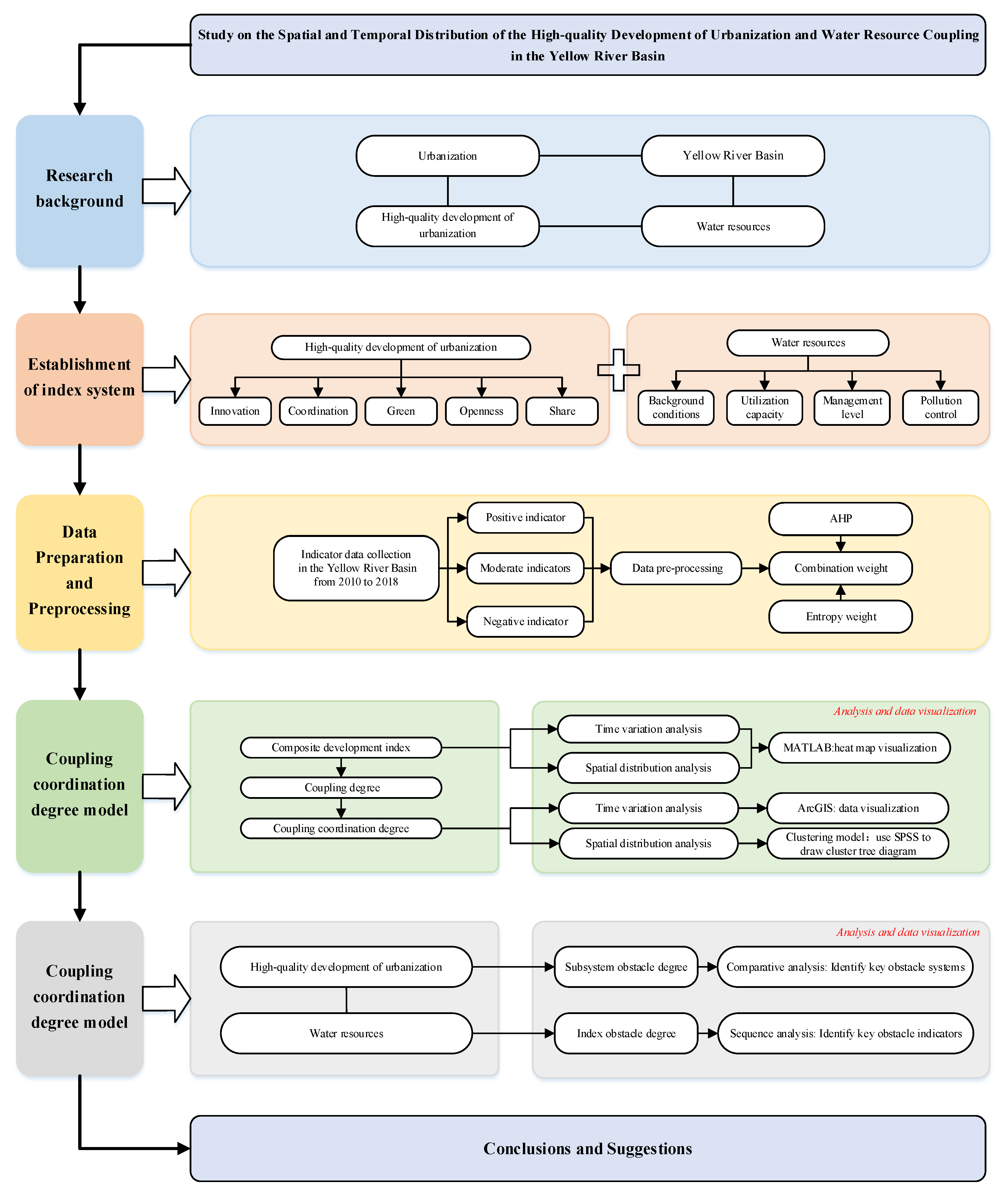
This paper uses a systematic process to explore the coordinated development relationship between the HQDU and the WRS (Figure 2). To this end, the research process is divided into four steps: (1) establish two indicator systems for the HQDU and the WRS; (2) pre–process the forward, reverse, and moderate indicator data into dimensionless values, and determine the weights of the indicators; (3) establish the CCD model and the obstacle degree model, and calculate the results; (4) analyze the coupling coordination status of the HQDU and the WRS.

3.3. The Concept of “High–Quality Urbanization Development—Water Resources Coupling” and the Construction of Index System

3.3.1. The Concept of “High–Quality Urbanization Development—Water Resources Coupling”

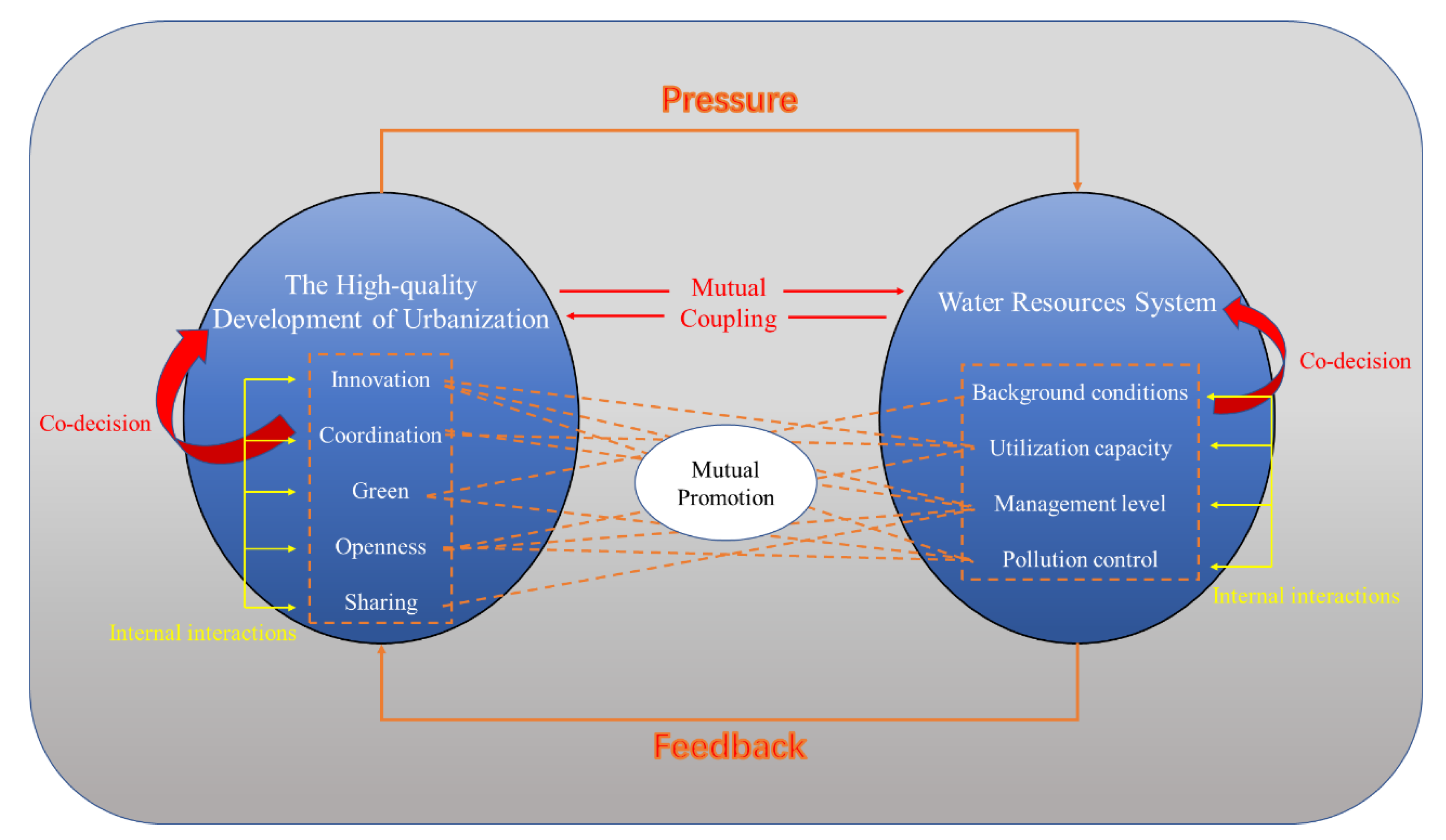
The term “coupling” originates from the physical concept of two (or more) systems influencing each other through interactions between themselves and the outside world [20], and at this stage, the concept of coupling has been widely applied to the study of the interrelationships between multiple subjects. The term “urban–water coupling” describes the phenomenon of interaction between cities and water resources through the relationship of interaction. Considering that the development direction of urbanization has changed to the stage of high–quality development, the process of high–quality development will accelerate the consumption of water resources. In order to ensure the relative coordination between the level of HQDU and WRS, this paper proposes the concept of “HQDU–WRS coupling” (as shown in Figure 3). The purpose of this study is to promote the coupling and coordination between the two and to investigate the spatial and temporal distribution between the HQDU and WRS. The essence of the concept of “HQDU–WRS coupling” is an ecological value that promotes the harmonious coexistence of human needs, social development, and water resources.
The concept of “HQDU–WRS coupling” is essentially a process of mutual adaptation, coordination, and development between two complex systems: HQDU and WRS, which are themselves complex issues. As shown in Figure 3, the HQDU puts a lot of pressure on the WRS, while the WRS will feedback to the HQDU, and the two are coupled and interact with each other. In addition, both HQDU and WRS are complex systems. In terms of HQDU, the new development concept and the idea of HQDU are compatible with each other. The new development concept includes five subsystems: innovation, coordination, green, openness, and sharing. The innovation subsystem focuses on solving the problem of development dynamics, the coordination subsystem focuses on solving the problem of unbalanced development, the green subsystem focuses on solving the problem of harmony between human beings and nature, the subsystem of openness focuses on solving the problem of internal and external linkage of development, and the subsystem of sharing focuses on solving the problem of social equity and justice. In terms of the WRS, it consists of water resource background conditions, utilization capacity, management level, and pollution control, and the enhancement or deterioration of these aspects will determine the development level of the WRS. In addition, there is a mutual influence and promotion relationship between the various subsystems of different systems.

3.3.2. The Construction of the Index System

To accurately evaluate the interrelationship between the HQDU and the WRS, based on the concept of “ HQDU–WRS coupling”, we established two index systems to evaluate WRS and HQDU based on relevant research results. The subsystems reflecting the WRS are the water resource background conditions, water resource utilization capacity, water resource management level, and water pollution control. And, 12 indicators are selected, such as total water resources, water resources per capita, total urban water supply, etc. The subsystems reflecting the level of the HQDU are innovation, coordination, green, openness, and sharing. And, 29 indicators are selected, such as R&D investment intensity, investment per capita in science and technology, education investment per capita, etc. (Table 1 and Table 2).

3.4. Research Method

3.4.1. Determination of the Weights of Indicators

The combined weight method is used to determine the weight of each indicator. This calculation method can effectively reduce the influence of subjective consciousness on the weights, and can also lessen the problem that the objective weights do not match the actual situation.

The Entropy Weight Method

The entropy weight method can eliminate the influence of people’s subjective impression of the weights. Entropy values can reflect the disorder degrees of information, measure the amount of information, and express the effectiveness of information:
(1)
Construct a judgment matrix composed of m evaluation objects and n evaluation indicators, and normalize it to obtain a standardized matrix R = ( r i j ) m × n :
R = ( r i j ) m × n = r 11 r 1 n r m 1 r m n
in which, for the indicators that belong to the “the larger the better (positive)” type:
r ij = x ij min { x 1 j , x 2 j , x m j } max { x 1 j , x 2 j , x m j } min { x 1 j , x 2 j , x m j }
for the indicators that belong to the “the smaller the better (negative)” type:
r i j = max { x 1 j , x 2 j , x m j } x ij max { x 1 j , x 2 j , x m j } min { x 1 j , x 2 j , x m j }
and for the moderate indicators:
r i j = max { x 1 j , x 2 j , x m j } | x ij t | max { x 1 j , x 2 j , x m j } min { x 1 j , x 2 j , x m j }
In this equation, t is a moderate value, the moderate value of the IU ratio is 0.5, and the moderate value of the NU ratio is 1.2 [24].
(2)
Define the entropy of the j–th indicator:
H j = i = 1 m F i j ln F i j ln m   i = 1 , 2 , m ;   j = 1 , 2 , n
in which
F i j = r i j i = 1 m r i j
(3)
Calculate the weight of the j–th indicator:
λ j = 1 H j j = 1 n ( 1 H j )

Analytic Hierarchy Process (AHP)

We construct the hierarchical model, as shown in Table 1 and Table 2. And, we construct the judgment matrix by using the scale method of 1~9 and their reciprocals. We use MATLAB for the calculation to obtain the maximum eigenvalue, λ max , of each judgment matrix and its corresponding weight vector, θ j , and substitute it in:
C I = λ max n n 1
We calculate the consistency index, which can be found in Table 3 [43], the random consistency index, RI, and according to the following equation:
C R = C I R I
We calculate the consistency ratio of the matrix. If C R < 0.1 , this indicates that the inconsistency degree of the matrix is within the allowable range, and the corresponding weight vector, θ j = ( θ 1 , θ 2 , θ j ) , obtained at this time is the required weight vector.

Combination Weight

After the subjective and objective weights are determined, we determine the comprehensive weight of each indicator by using the combination weight Equation (10). Because there are great differences among the indicators of the research object in this paper, neither the entropy weight method alone nor the AHP method can have the feature of being consistent with the actual situation while guaranteeing the objectivity of the weights. Therefore, the two methods are combined to avoid this situation and truly reflect the weights of the evaluation indicators.
ω j = λ j θ j j = 1 j λ j θ j

3.4.2. Coupling Coordination Degree Model

Comprehensive Development Index

The comprehensive development index in the i –th year is:
S i = j = 1 m ω j r i j
In the above equation, m is the number of indicators included in the indicator system.

Coupling Coordination Degree (CCD)

The concept of coupling degree is a concept in physics. It is a concept that is used in expressing the degree of interaction and mutual influence of two subsystems. The coupling of the HQDU and WRS refers to the gradual integration of the coupling elements of the two subsystems into an affinitive functional combination that has new functions. The coupling degree, C ( t ) , between the system of HQDU, S ( 1 , t ) , and the WRS, S ( 2 , t ) , of the YRB in year t is defined as the following equation:
C ( t ) = S ( 1 , t ) S ( 2 , t ) [ S ( 1 , t )   +   S ( 2 , t ) 2 ] 2
Among them, 0 C ( t ) 1 , and in the equation, S ( 1 , t ) = j = 1 m ω 1 j r 1 i j and S ( 2 , t ) = j = 1 m ω 2 j r 2 i j , where ω 1 j and ω 2 j represent the weight of each indicator of the HQDU and the WRS, respectively. r 1 i j and r 2 i j represent the data of the standardized indicators of the two systems, i.e., the HQDU and the WRS, respectively. The classification of the coupling degrees is shown in Table 4 [44].
The coupling degree, C ( t ) , can only describe the size relationship of coupling strength between the systems but cannot reflect the overall synergy effect of the composite system well. That is, there may be a phenomenon that all the comprehensive evaluation values of two subsystems are low but their coupling degree is very high. So, the coupling coordination function, D ( t ) , of System S ( 1 , t ) and System S ( 2 , t ) in year t is defined as:
D ( t ) = T C ( t )
In this equation, T is the comprehensive evaluation value of the two subsystems, i.e., the HQDU and the WRS, T = α S ( 1 , t ) + β S ( 2 , t ) , where α and β are undetermined coefficients, set as 0.5 and 0.5, respectively. The specific CCD classification is shown in Table 5 [1,14,45].

3.4.3. Cluster Analysis Model with Ward’s Method

Cluster analysis is a statistical analysis method to study the classification of samples or indicators, the purpose of which is to classify data based on similarity. Cluster analysis is to gradually aggregate the samples according to the similarity of the quality characteristics, the ones with the greatest similarity are first aggregated, and finally, multiple varieties are aggregated according to the comprehensive nature of the class, thereby completing the process of cluster analysis [46].
The Ward method is a kind of systematic clustering method, and its idea comes from ANOVA; if the classification is correct, the sum of squares of deviations in similar samples should be smaller, and the sum of squares of deviations between classes should be larger [47]. The method of the sum of squares of deviations is to use the squared Euclidean distance as the distance between two classes and to form each sample in the set into a class by itself. When performing category merging, the variance between the centers of gravity of the classes is calculated, and the two classes with the smallest increase in the sum of squares of deviations are merged first, and then, all classes are merged, in turn, step by step [48]. The specific algorithm is as follows:
We divide n regional samples into k classes: G 1 , G 2 , , G k . We use X i ( t ) to represent the i –th sample in G t (here, X i ( t ) is a p –dimensional vector, which means there are p systematic clustering indicators), n t represents the number of samples in G t , and X ¯ ( t ) is G t ‘s center of gravity (the mean value of this class of samples), so the sum of squared deviations of the sample in G t is as follows:
S t = i = 1 n t ( X t ( t ) X ¯ ( t ) ) ( X i ( t ) X ¯ ( t ) )
and then, the sum of squared deviations within the k classes is as follows:
S = t = 1 k S t = t = 1 k i = 1 n t ( X i ( t ) X ¯ ( t ) ) ( X i ( t ) X ¯ ( t ) )

3.4.4. Obstacle Degree Model

To analyze the CCD between the HQDU and the WRS in the YRB, we introduced the obstacle degree model to identify and diagnose the key factors that hinder the CCD enhancement of the two. The obstacle degree equation is as follows:
Q j = ω j ( 1 r i j ) j = 1 m ω j ( 1 r i j )

4. Results and Discussion

4.1. Comprehensive Development Index

4.1.1. Comprehensive Development Index in the Yellow River Basin

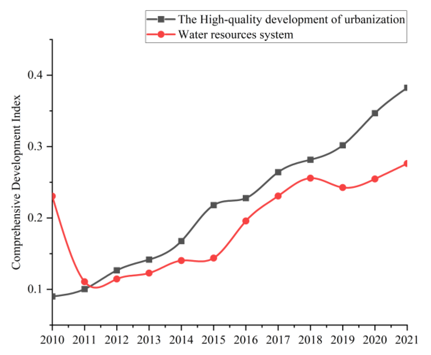
Figure 4 shows the temporal trend of comprehensive development indices of the HQDU and the WRS in the YRB. From 2010 to 2021, the comprehensive development index of the HQDU in the study area showed a trend of “continuous and steady rise”, and in 2015, the phenomenon of “slightly accelerated development speed” appeared, with the level rising from 0.0901 in 2010 to 0.3824 in 2021. The comprehensive development index of the WRS showed a trend of “a sharp decline first, and then a steady increase”. The comprehensive development index of the WRS dropped sharply in 2011, and rose steadily from 2012 to 2018. Only in 2015 and 2019, there was a trend of “development speed slowing down slightly”. The comprehensive development index of the WRS dropped from 0.2306 in 2010 to 0.1106 in 2011 and then rose steadily to 0.2763 in 2021.

4.1.2. Comprehensive Development Index of Nine Provinces

Figure 5a shows the temporal trend of the comprehensive development index of the HQDU in the YRB by province. Between 2010 and 2021, the comprehensive development index of the HQDU in the YRB showed a trend of “general increase with occasional fluctuations”. The comprehensive development index of the HQDU in Inner Mongolia, Sichuan, Gansu, and Ningxia in 2011; Shandong in 2012; Shanxi in 2015; Inner Mongolia and Ningxia in 2016; Inner Mongolia and Ningxia in 2018; and Shanxi in 2019 had a small decrease compared with the previous year. For the rest of the time period, the comprehensive development indices of the HQDU in all provinces increased steadily.
The comprehensive development index of the WRS in the provinces of the YRB is shown in Figure 5b, which showed a “first decreasing, then increasing, with occasional fluctuations” trend from 2010 to 2018. The comprehensive development index of the WRS in the nine provinces of the YRB decreased from 2010 to 2011 and was generally on the rise from 2011 to 2018. Among them, the decrease in the index in 2011 was caused by the sudden increase in the total wastewater discharge and chemical oxygen demand in the provinces. Shanxi and Shaanxi in 2012; Sichuan and Shaanxi in 2013; Inner Mongolia and Sichuan in 2015; Gansu in 2016; Shanxi in 2017; Inner Mongolia, Shandong, and Shaanxi in 2020; and Gansu and Qinghai all had different degrees of decline in the comprehensive development index compared with the previous year. It is noteworthy that the decline in the comprehensive development index of WRS in Gansu in 2016 was quite large, which was mainly due to the decline in the total urban water supply and urban daily sewage treatment capacity.

4.1.3. Comprehensive Development Index of Subsystems

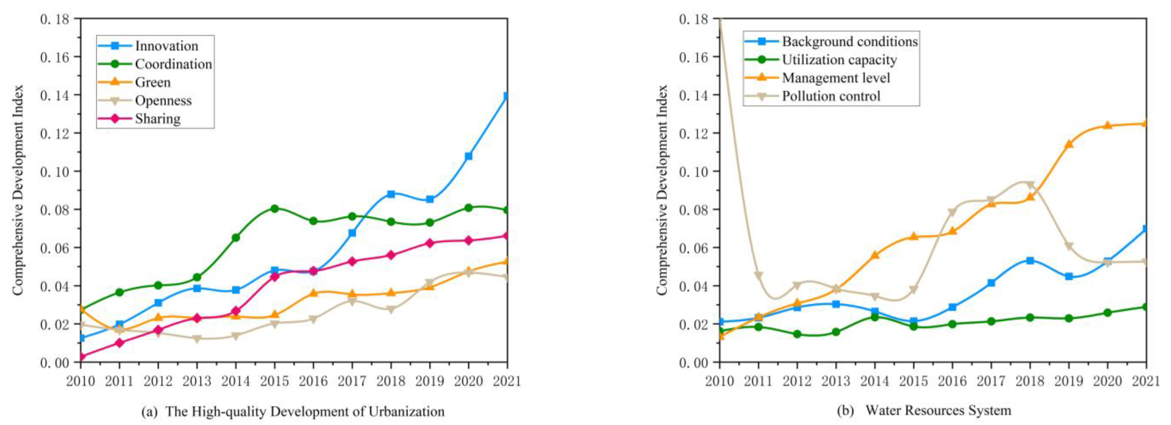
The changes in the comprehensive development index of each subsystem in the HQDU and the WRS are shown in Figure 6a,b. As shown in Figure 6a, in terms of the HQDU, all five subsystems, in general, have increased to varying degrees between 2010 and 2021. Two of these subsystems, i.e., innovation and sharing, showed varying degrees of increase each year during the study period; the coordination system showed a small decrease in 2016; the green system showed a small decrease in 2011; and the openness system showed a continuous downward trend from 2011 to 2013 and began to show an upward trend after 2014. As shown in Figure 6b, for the WRS, only the level of water resource management improved “steadily and evidently” between 2010 and 2021, from 0.0132 in 2010 to 0.1249 in 2021; however, the water resource utilization capacity subsystem was not evidently improved and fluctuated to different degrees during the study period, and in general, these subsystems showed a status of “small improvement and recurrent fluctuations”. The water background conditions subsystem showed a “fluctuating increase” during the study period, with a significant decrease in 2015 and 2019. It is worth noting that the water resource pollution control subsystem fluctuated to a large extent during the study period. In 2011, there was a significant drop in the comprehensive development index of water resource pollution control, which was mainly due to the sudden increase in the two indicators, i.e., the total wastewater discharge and the chemical oxygen demand emissions. The water resource pollution control subsystem kept decreasing slightly and steadily between 2012 and 2015 but then showed a sudden increase in 2016, which was mainly caused by a sudden drop in chemical oxygen demand emissions without a significant change in total wastewater discharge. Between 2017 and 2018, water pollution control showed a steady upward trend, but in 2019, there was another significant drop, mainly due to a sudden increase in COD emissions.

4.2. Coupling Coordination Status

4.2.1. Temporal Variation in the Coupling Coordination Degree

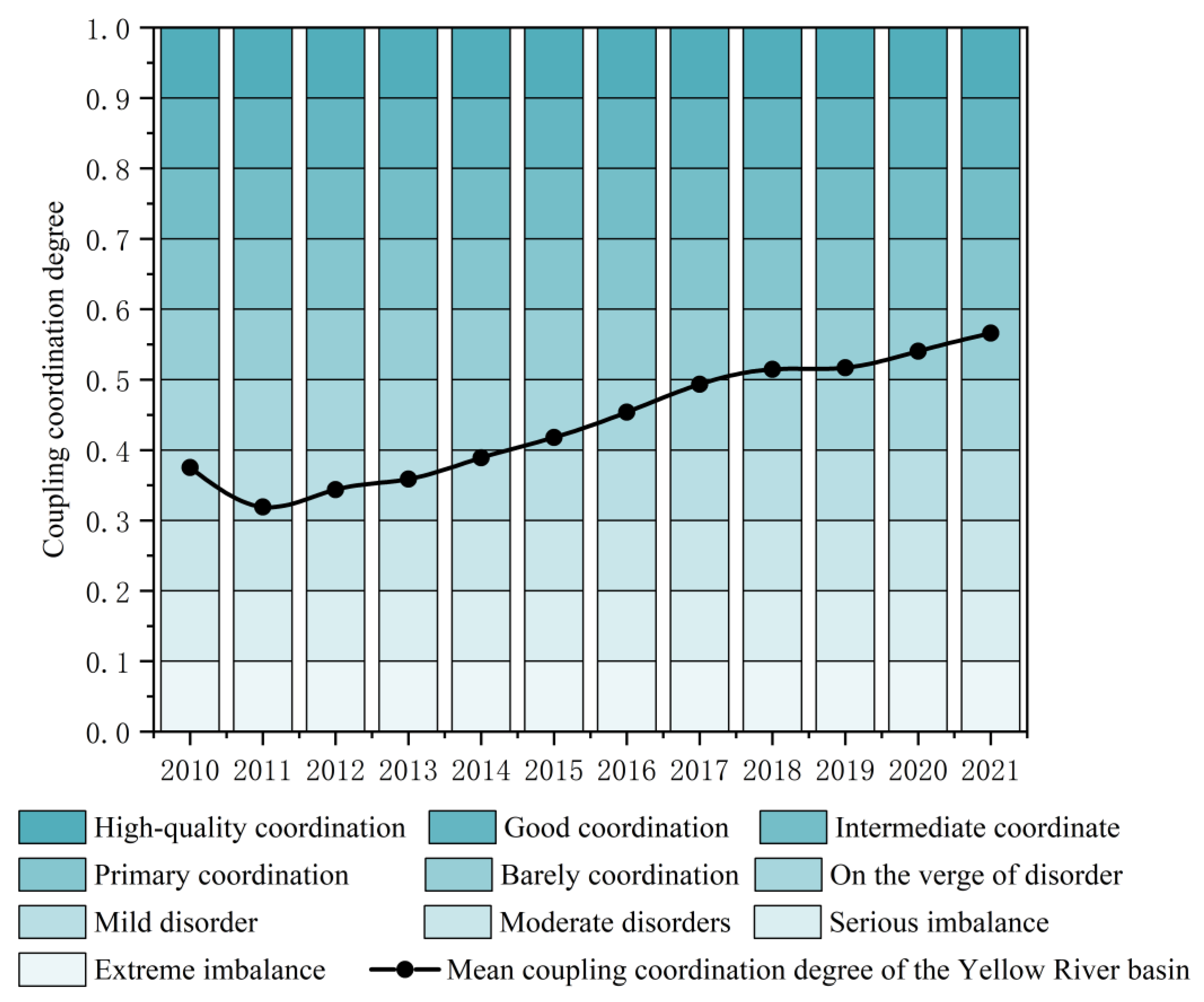
Figure 7 reveals the CCD and the classes to which they belong in the YRB from 2010 to 2021. As shown in the figure, the CCD between the HQDU and the WRS generally showed an increased state during the study period, from 0.3751 in 2010 to 0.5661 in 2021. The results indicate that the CCD between the HQDU and the WRS improved to some extent and maintained a state of continuous improvement. From 2010 to 2021, there was a dynamic evolution in the CCD between the two systems, shifting from a “mild disorder” to a state of “barely coordination”. Specifically, between 2010 and 2014, the two systems in the YRB were in a state of “mild disorder”, while between 2015 and 2017, they shifted to a state of “on the verge of disorder”, then to a state of “barely coordination” between 2018 and 2021.
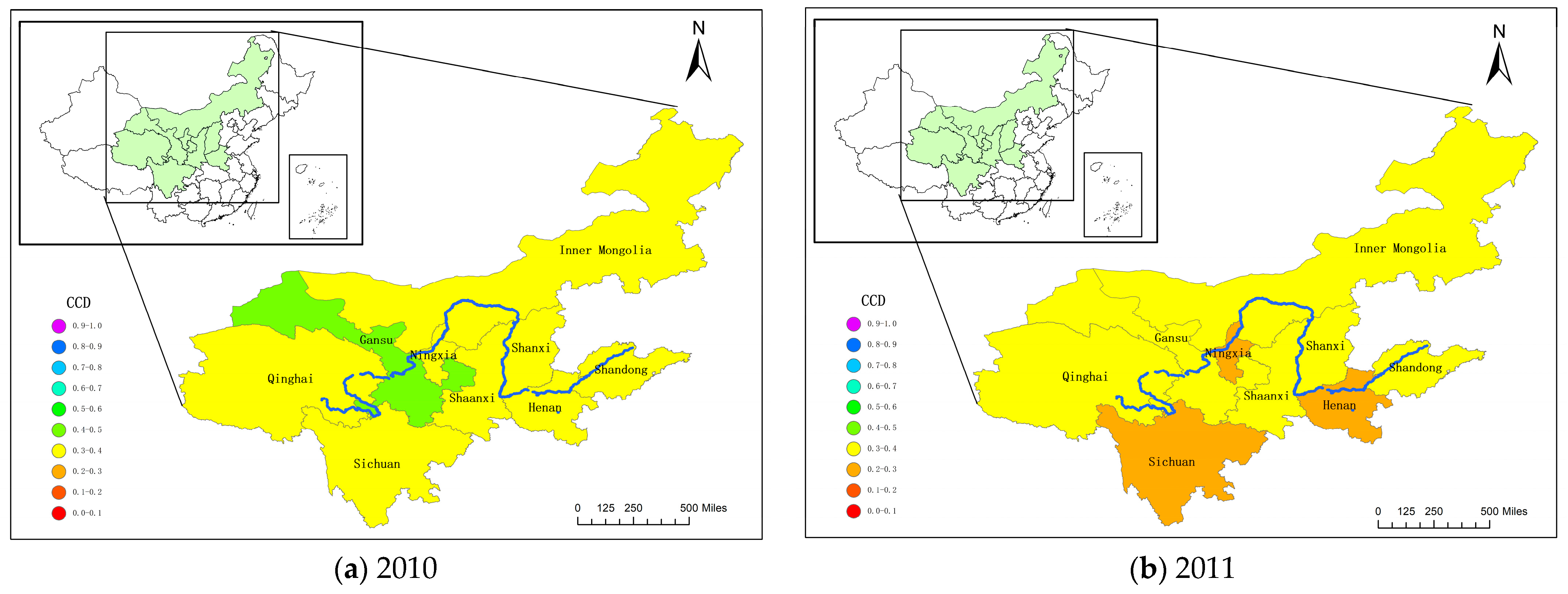
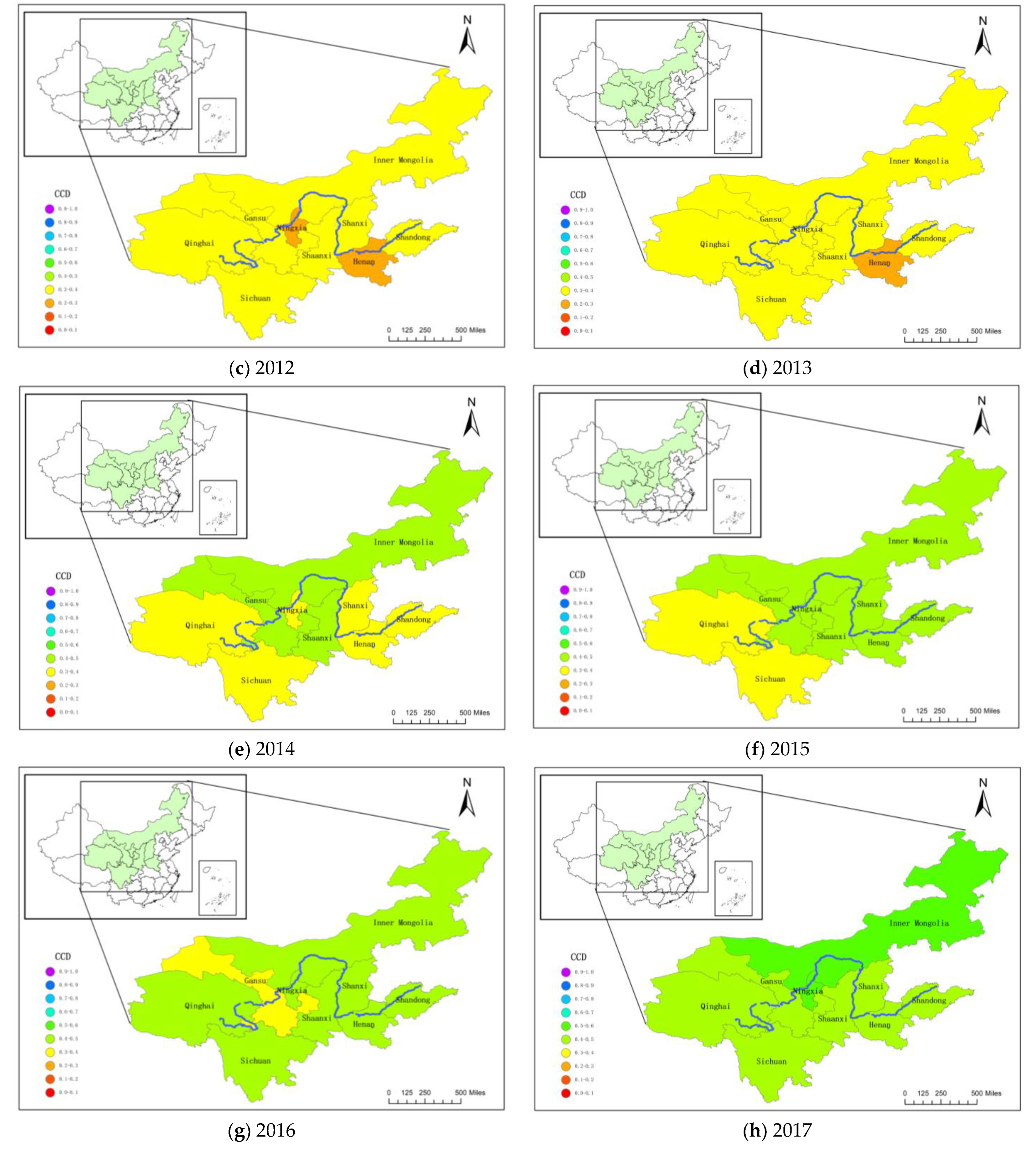
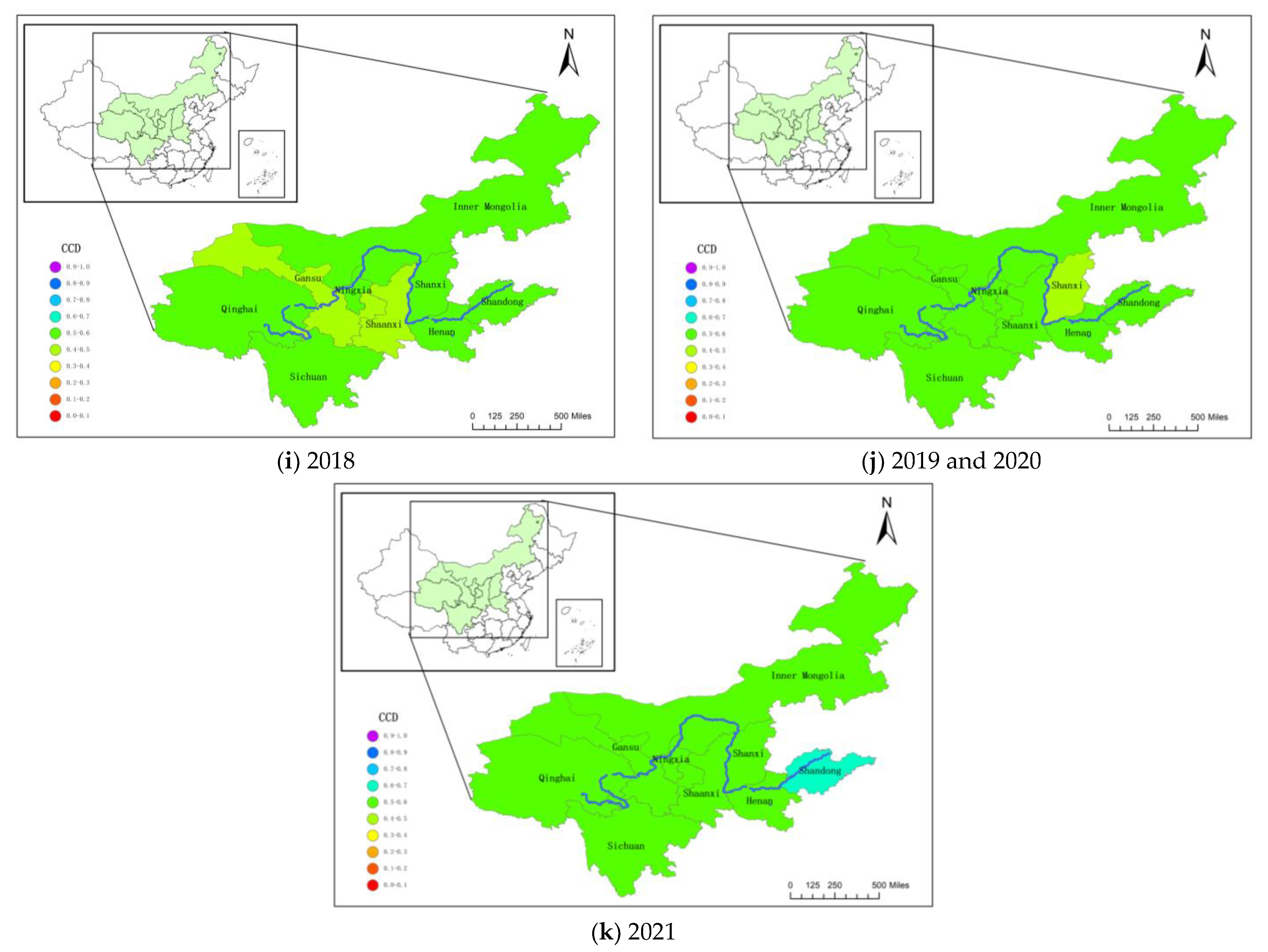
To better explore the temporal and spatial variations in the CCD in the YRB provinces, we used ArcGIS to plot the images of CCD for each year, as shown in Figure 8. During the study period, the coupling coordination levels between the HQDU and the WRS in all provinces of the YRB increased to different extents. The CCD between the two systems in Shanxi province was at a “mild disorder” stage from 2010 to 2013, turned into the “on the verge of disorder” stage from 2014 to 2017, briefly improved to the “barely coordination” stage in 2018, fell back to the “on the verge of disorder” stage in 2019 and 2020, and improved again to the “barely coordination” stage in 2021. The CCD between the two systems in Shandong province was at a “mild disorder” stage from 2010 to 2014, turned into the “on the verge of disorder” stage from 2015 to 2017; they were in the state of “barely coordination” during 2018 to 2020 and transformed into “primary coordination” in 2021. The CCD of the two systems of Inner Mongolia was at a “mild disorder” stage from 2010 to 2013, turned to an “on the verge of disorder” stage from 2014 to 2016, and was in a state of “barely coordination” from 2017 to 2021. The CCD of the two systems in Henan Province was at the “mild disorder” stage in 2010; after being downgraded to “moderate disorder” from 2011 to 2013, it returned to the “mild disorder” stage in 2014, transformed to the “on the verge of disorder” stage in 2015 and 2017, and then shifted to the “barely coordination” stage after 2018. The CCD of the two systems in Sichuan Province was at a “mild disorder” stage in 2010, and after a brief downgrade to the “moderate disorder” stage in 2011, shifted to the “on the verge of disorder” stage between 2012 and 2015, continued to turn better between 2016 and 2017 and changed into the “on the verge of disorder” stage, and finally shifted to a “barely coordination” level after 2018. The CCD of the two systems of Shaanxi province was in a “mild disorder” state between 2010 and 2014, developed rapidly after 2015 and was at an “on the verge of disorder” stage between 2015 and 2018, and was at a “barely coordination” level from 2019 to 2021. Gansu Province was in the state of “on the verge of disorder” in 2010, downgraded to “mild disorder” in 2011 and 2012, then upgraded to “on the verge of disorder” from 2013 to 2018, and shifted to “barely coordination” stage in 2019 and 2021. Qinghai Province was in a “mild disorder” state between 2010 and 2016, then at the “on the verge of disorder” stage in 2017, and shifted to the “barely coordination” stage after 2018. The CCD of the two systems of Ningxia was at the level of “mild disorder” in 2010 and 2011, and after a brief downgrade to “moderate disorder” in 2012 and 2013, it was quickly adjusted, shifting to the “on the verge of disorder” stage in 2015 and 2016, skipping the “barely coordination” stage after 2017.
There is no doubt that during the past nine years, the process of HQDU has imposed enormous pressure on local water resources for each province. Between 2010 and 2021, the level of the HQDU continued to rise, while the WRS showed a sudden drop in 2011 and a quite stable upward trend afterward, and a small inverse growth again in 2018. Moreover, the improvement in the level of the WRS was mainly due to the substantial increase in the level of water resource management, while the increases in the background conditions of water resources and the water resource utilization capacity were not obvious, and there were substantial fluctuations in the water resource pollution control, and the development level was unstable, with a sudden drop in 2011 and a sudden increase in 2018. It can be foreseen that under the existing water resource conditions, in the near future, the level of water resource management will encounter a bottleneck, and it is not realistic for the improvement in the overall level of water resource systems to rely on the change in the background conditions of water resources. Therefore, the future development opportunities of the WRS for the YRB lie in the improvement in water resource utilization capacity and the continuous and stable improvement in pollution control levels. In response to the shortage of water resources and the development needs in the YRB, the state put forward the strategy of “Ecological Conservation and High–quality Development of the YRB”, in which the development principle of “continuing setting cities by water, setting lands by water, setting people by water and setting productions by water, and taking water resource as the biggest rigid constraint” [49]. Therefore, due to the current situation of water resources, the process of urbanization and high–quality development should not be too fast but should be consistent with the level of water resources, so as not to cause the situation of “emphasizing development and neglecting ecology”.

4.2.2. Spatial Variation of Coupling Coordination Degrees

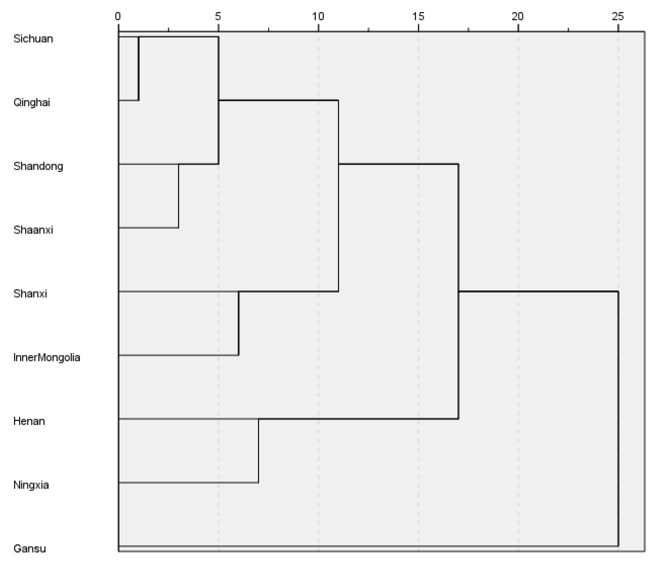
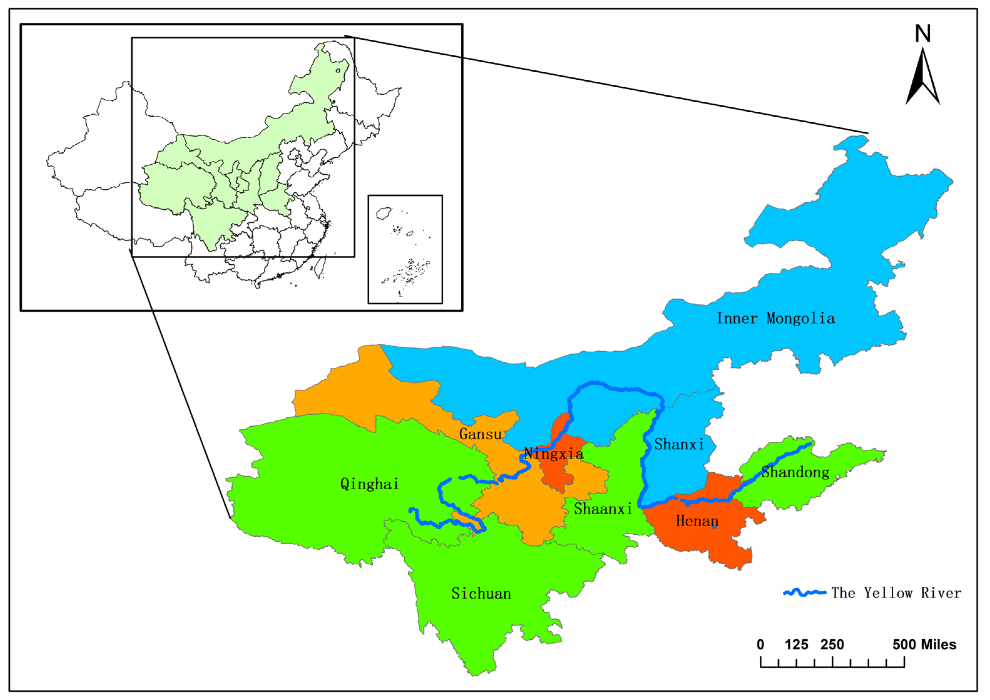
In order to better analyze and compare the differences in the CCD of the HQDU and the WRS in the provinces of the YRB, we take the CCD of the two systems in the nine provinces of the YRB as the basis, use the SPSS 26 statistical analysis tool, and choose Ward’s method for systematic cluster analysis, and the results are shown in Figure 9. Considering that the number of iterations between groups should not be too large or too small, we use the “Euclidean distance = 10” as a criterion to divide the CCD of the nine provinces in the YRB into four classes, which are shown in Figure 9 and Figure 10.
As shown in Figure 9 and Figure 10, Shanxi and Inner Mongolia are put into one class; Sichuan, Qinghai, Shandong, and Shaanxi are put into one class; Henan and Ningxia are put into one class; and Gansu alone is put into one class. The levels of the CCD of the two systems among the four class groups showed different development trends. Among them, the development of Henan and Ningxia group was characterized by a quite low level of CCD of the two systems at the beginning of the study period and a brief decline in a certain stage (2011 to 2013), but the group developed rapidly in the later part of the study period and even had the tendency to catch up with and surpass other provinces. Shanxi and Inner Mongolia group belonged to the class with balanced development, and the level of CCD of the two systems grew steadily during the study period without obvious fluctuations, which showed a benign and stable development trend. The level of CCD of the two systems in Sichuan, Shandong, Shaanxi, and Qinghai group was basically in a “mildly disorder” state in the first half of the study period with a long duration and low level, but in the second half of the study period, the development speed increased and basically caught up with the CCD levels of the other groups. Gansu group was at a quite high level in the early part of the study period, and before 2014, all the CCDs of the two systems in Gansu Province were at the highest levels among the nine provinces in the YRB, but after that, the coupling coordination level of the two systems in Gansu Province did not improve significantly and developed slowly. As of 2021, Gansu Province had been overtaken by other provinces, and the CCD was the lowest in the YRB.

4.3. Diagnosis of Obstacle Factors

In order to identify the obstacle factors for the CCD of the HQDU and the WRS in the YRB, in this paper, we use the obstacle degree model to diagnose its obstacle factors and analyze them, and the results are shown in Table 6. In the system of HQDU, the greatest obstacles are the innovation subsystem from 2010 to 2019 and the coordination subsystem in 2020 and 2021. Comparatively, the obstacle levels of the green subsystem were the lowest in 2010 to 2014, and 2016; the obstacle levels of the green subsystem were the lowest obstacles in 2015 and 2017 to 2021. In the WRS, the subsystems with the highest obstacle levels were the water resources management level in 2010, and the water resources pollution control subsystem from 2011 to 2021, while the subsystem with the lowest obstacle levels was always the water resource utilization capacity.
By indicator, the top five obstacles that hinder the CCD of the HQDU and the WRS are shown in Table 7. The ranking of each factor changed to various extents in different years. In the system of the HQDU, the ones that appeared most frequently on the list were A4—Technology Market Turnover as a Percentage of GDP, A7—Number of patent applications granted per 10,000 people, A10—Coordination Index of Urbanization Economic Growth Speed, A5—Innovative Product Profitability, and A21—Foreign Investment Openness, which had been on the list twelve, eleven, eleven, ten, and ten times, respectively. The obstacle factors that appeared on the top three list most frequently in various years were the A4—Technology Market Turnover as a Percentage of GDP, A10—Coordination Index of Urbanization Economic Growth Speed, and A21—Foreign Investment Openness, which had been on the list ten, nine, and eight times, respectively. And, in the WRS, the ones that had been on the top five list most frequently were B3—Total urban water supply, B7—Comprehensive Production Capacity of Water Supply, B10—Total Wastewater Discharge, B11—Codm and B2—Water resources per capita, and they had been on the list twelve times, twelve times, eleven times, eight times, and six times, respectively. And, the obstacle factors that appeared on the top three list most frequently in various years were B7—Comprehensive Production Capacity of Water Supply, B10—Total Wastewater Discharge, and B11—Cod, and the number of times they appeared on the list of the top three was eleven, eleven, and eight times, respectively.

4.4. Comparative Analysis

In a related study, An, Li, Wang, Dong, Dai, and Liang [1] explored the spatial and temporal distribution characteristics of the high–quality development of urbanization in the Yellow River Basin, the nine provinces of which showed an upward trend in the level of urbanization, and the results of their study are similar to those of this paper. Qiao, Li, and Han [45] explored the coordination between urbanization and water resource carrying capacity in the YRB, and concluded that the coordination between the two improved between 2008 and 2017; in addition, in terms of the level of urbanization, in the study area, except for Gansu Province, where it declined slightly, all the others increased to varying degrees, which is consistent with the findings of this paper. And, the findings can provide an effective reference basis for the formulation of the framework for the HQDU and the WRS in the region.

5. Conclusions and Suggestions

In the past nine years, the YRB has experienced a shift from high–speed development to high–quality development in its urbanization process. Under the premise that water resources are the biggest rigid constraint, the process of HQDU is bound to bring unprecedented pressure on regional water resources. This study proposes the concept of “HQDU—WRS coupling” and applies it to the construction of the index system. We adopted the CCD model and the obstacle degree model to analyze and explore the coupling coordination relationship between the HQDU and the WRS in the YRB and used ArcGIS10.6 and Spss26 software for data visualization, aiming to explore the coupling and coordination relationship between the high–quality development of urbanization and water resources in the Yellow River Basin, and providing a reference for the high–quality development of urbanization and water resources in the Yellow River Basin. In this study, the following conclusions are reached: At the temporal level, the comprehensive development indices of both the HQDU and the WRS showed an upward trend. The comprehensive development index of the HQDU increased from 0.0901 to 0.3824, and the comprehensive development index of the WRS increased from 0.2306 to 0.2763. The state of CCD between the HQDU and WRS in the YRB has improved to some extent. In general, it has improved from “mild disorder” to “barely coordination”. At the spatial level, the CCD of the HQDU and the WRS in the YRB is generally divided into four classes: Henan and Ningxia showed the characteristics of a low level of CCD in the early stage of the study period and a further decreasing trend, and fast development speeds in recent years; Shanxi and Inner Mongolia showed a stable development speed in the study period; Sichuan, Shandong, Shaanxi, and Qinghai showed the characteristics of low levels of CCD in the early stage of the study, which lasted for quite a long period of time, and increases in development speed in the later part of the study period; Gansu Province had a relatively high level of CCD in the early part of the study period, but the development speed was slow, and the momentum was insufficient. In the system of HQDU, the three indicators which are the Coordination Index of Urbanization Economic Growth Speed, Innovative Product Profitability, and Technology Market Turnover as a Percentage of GDP are the main obstacle factors, and in the WRS, the three indicators which are the Comprehensive Production Capacity of Water Supply, Total Wastewater Discharge, and Cod are the most important obstacle factors.
For the nine provinces in the YRB, HQDU should focus on the development of two systems: innovation and coordination. The regions need to take advantage of their regional advantages, promote the transformation of industrial structure, and strengthen the introduction of talents while increasing the development of innovation and technologies to provide the basis for scientific and technological innovation and development. The regions should vigorously support the development of innovative enterprises, provide employment opportunities in cities and towns, and promote the gradual transformation of industrial structure from primary and secondary industries to tertiary industries. In response to the strategic goal of “emission peak and carbon neutral”, the regions should strengthen environmental management, actively promote the development of green industries, and formulate corresponding policies to encourage enterprises to develop energy–saving and emission reduction projects on their own to move closer to the goal of zero industrial emissions. At the same time, the regions also need to actively promote the construction of service infrastructure and actively introduce foreign investment to facilitate the high–quality development of the regions. In terms of WRS, they should focus on improving the management level and pollution control level. The regions need to further plan the laying of urban water supply and drainage pipelines; improve the level of water intake, purification, delivery, and factory water transmission trunk of water supply facilities; and further improve the comprehensive production capacity of water supply. At the same time, the regions need to strictly control wastewater discharge standards and strengthen the supervision of wastewater discharge. They need to establish new–type sewage treatment plants to improve urban sewage treatment capacity and sewage treatment efficiency. As the YRB is a water shortage area, the background conditions of water resources in most regions are not optimistic. The recycling and reuse of reclaimed water have become an important way to alleviate regional water shortages. They need to improve people’s acceptance of recycled water and actively promote water recycling and reuse of reclaimed water to solve the contradiction between the HQDU and regional water shortage.
Although some achievements have been made in recent years in the CCD of the HQDU and the WRS in the YRB, the pressure on regional water resources caused by the high–quality development process is further expanding. On the one hand, good water resource conditions have contributed to the advancement of the process of the HQDU; on the other hand, the high–quality process has also brought great pressure on water resources, and it is crucial to ensure a coherent relationship between water resources and the high–quality development of urbanization. In the strategic context of ecological conservation and the high–quality development of the YRB, the guideline of continuing to set cities by water, setting lands by water, setting people by water and setting productions by water, and taking water resource as the biggest rigid constraint has become an important reference basis for the decision makers of regional development.

Author Contributions

All authors contributed to the study’s conception and design. L.W. defined the framework and ideas of this study and proposed revisions to the first draft; data collection and analysis were performed by X.H., Y.W. and P.Z.; J.S. participated in the construction of the research model, suggested revisions to the first draft and provided financial support; and F.S. suggested revisions to the article. The first draft of the manuscript was written by X.H., and all authors commented on previous versions of the manuscript. All authors have read and agreed to the published version of the manuscript.

Funding

This work was supported by Hohai University, Key Technologies for Evaluation and Improvement of Water Resources Asset Management in the Yangtze River Mainstem Based on the Conservation Needs of the Yangtze River (B200204019).

Institutional Review Board Statement

Ethical approval is not applicable for this article.

Informed Consent Statement

Informed consent was obtained from all individual participants included in the study.

Data Availability Statement

The datasets used or analyzed during the current study are available from the corresponding author upon reasonable request.

Conflicts of Interest

The authors declare no conflict of interest.

References

  1. An, X.W.; Li, Y.; Wang, L.Y.; Dong, G.H.; Dai, B.X.; Liang, M.X. The Spatial and Temporal Distribution of High–Quality Urbanization Development in Yellow River Basin Provinces. Sustainability 2022, 14, 10355. [Google Scholar] [CrossRef]
  2. Bloom, D.E.; Canning, D.; Fink, G. Urbanization and the wealth of nations. Science 2008, 319, 772–775. [Google Scholar] [CrossRef] [Green Version]
  3. Michaels, G.; Rauch, F.; Redding, S.J. Urbanization and Structural Transformation. Q. J. Econ. 2012, 127, 535–586. [Google Scholar] [CrossRef]
  4. Kolko, J. Urbanization Agglomeration and Coagglomeration of Service Industries; University of Chicago Press: Chicago, IL, USA, 2010; Volume 89. [Google Scholar]
  5. Turok, I.; McGranahan, G. Urbanization and economic growth: The arguments and evidence for Africa and Asia. Environ. Urban. 2013, 25, 465–482. [Google Scholar] [CrossRef]
  6. Mcgranahan, G.; Songsore, J.; Kjellen, M. Sustainability Poverty and Urbanenvironmental transitions. Sustain. Environ. Urban. 1996, 132–140. [Google Scholar]
  7. Gu, C.L.; Hu, L.Q.; Cook, I.G. China’s urbanization in 1949–2015: Processes and driving forces. Chin. Geogr. Sci. 2017, 27, 847–859. [Google Scholar] [CrossRef]
  8. Chen, M.X.; Liu, W.D.; Tao, X.L. Evolution and assessment on China’s urbanization 1960–2010: Under–urbanization or over–urbanization? Habitat Int. 2013, 38, 25–33. [Google Scholar] [CrossRef]
  9. Chu, N.; Zhang, P.; Wu, X. Spatiotemporal evolution characteristics of urbanization and its coupling coordination degree in Russia—Perspectives from the population, economy, society, and eco–environment. Environ. Sci. Pollut. Res. 2022, 29, 61334–61351. [Google Scholar] [CrossRef]
  10. Zhou, J.Y.; Zhang, X.L.; Shen, L.Y. Urbanization bubble: Four quadrants measurement model. Cities 2015, 46, 8–15. [Google Scholar] [CrossRef]
  11. Wang, B.; Gao, X. Temporal and spatial variations of water resources constraint intensity on urbanization in the Shiyang River Basin, China. Environ. Dev. Sustain. 2020, 23, 10038–10055. [Google Scholar] [CrossRef]
  12. Avazdahandeh, S.; Khalilian, S. The effect of urbanization on agricultural water consumption and production: The extended positive mathematical programming approach. Environ. Geochem. Health 2020, 43, 247–258. [Google Scholar] [CrossRef]
  13. Mu, L.; Fang, L.; Dou, W.; Wang, C.; Qu, X.; Yu, Y. Urbanization–induced spatio–temporal variation of water resources utilization in northwestern China: A spatial panel model based approach. Ecol. Indic. 2021, 125, 107457. [Google Scholar] [CrossRef]
  14. Zhang, K.Z.; Shen, J.Q.; He, R.; Fan, B.H.; Han, H. Dynamic Analysis of the Coupling Coordination Relationship between Urbanization and Water Resource Security and Its Obstacle Factor. Int. J. Environ. Res. Public Health 2019, 16, 4765. [Google Scholar] [CrossRef] [PubMed] [Green Version]
  15. Wang, Y.; Xiao, W.H.; Wang, Y.C.; Zhao, Y.; Wang, J.H.; Hou, B.D.; Song, X.Y.; Zhang, X.L. Impact of China’s Urbanization on Water Use and Energy Consumption: An Econometric Method and Spatiotemporal Analysis. Water 2018, 10, 1323. [Google Scholar] [CrossRef] [Green Version]
  16. Han, H.; Li, H.M.; Zhang, K.Z. Spatial–Temporal Coupling Analysis of the Coordination between Urbanization and Water Ecosystem in the Yangtze River Economic Belt. Int. J. Environ. Res. Public Health 2019, 16, 3757. [Google Scholar] [CrossRef] [PubMed] [Green Version]
  17. Zhang, Q.; Peng, J.T.; Singh, V.P.; Li, J.F.; Chen, Y.Q.D. Spatio–temporal variations of precipitation in arid and semiarid regions of China: The Yellow River basin as a case study. Glob. Planet. Chang. 2014, 114, 38–49. [Google Scholar] [CrossRef]
  18. National Bureau of Statistics of China. China Statistical Yearbook; China Statistics Press: Beijing, China, 2011–2022.
  19. China Bureau of Statistics. China Urban Statistical Yearbook; China Statistics Press: Beijing, China, 2011–2022.
  20. Wang, M.; Zhao, X.L.; Gong, Q.X.; Ji, Z.G. Measurement of Regional Green Economy Sustainable Development Ability Based on Entropy Weight–Topsis–Coupling Coordination Degree–A Case Study in Shandong Province, China. Sustainability 2019, 11, 280. [Google Scholar] [CrossRef] [Green Version]
  21. Xu, H.; Shi, N.; Wu, L.; Zhang, D. High–quality development level and its spatiotemporal changes in the Yellow River Basin. Resour. Sci. 2020, 42, 115–126. [Google Scholar] [CrossRef]
  22. He, W. Comprehensive Evaluation of Chinas Regional Economic Development Quality Based on RAGA–PPC. J. Zhongnan Univ. Econ. Law 2013, 4, 49–56. [Google Scholar]
  23. Shi, Y.; Zhu, Q.; Xu, L.; Lu, Z.; Wu, Y.; Wang, X.; Fei, Y.; Deng, J. Independent or Influential? Spatial–Temporal Features of Coordination Level between Urbanization Quality and Urbanization Scale in China and Its Driving Mechanism. Int. J. Enviorn. Res. Public Health 2020, 17, 1587. [Google Scholar] [CrossRef] [Green Version]
  24. Lan, Q.; Liu, Z.; Peng, Y. The Construction of Evaluation Index System for Quality of New—pattern Urbanization and its Evaluation Method: Based on Study of Spatial Differences among China’s 31 provinces (cities) during the year of 2003 to 2014. South China J. Econ. 2017, 1, 111–126. [Google Scholar]
  25. Zhang, T.; Li, L. Research on temporal and spatial variations in the degree of coupling coordination of tourism–urbanization–ecological environment: A case study of Heilongjiang, China. Environ. Dev. Sustain. 2021, 23, 8474–8491. [Google Scholar] [CrossRef]
  26. Fang, G.; Wang, Q.; Tian, L. Green development of Yangtze River Delta in China under Population–Resources–Environment–Development–Satisfaction perspective. Sci. Total Environ. 2020, 727, 138710. [Google Scholar] [CrossRef] [PubMed]
  27. Ma, R. Study of Evaluating High–quality Economic Development in Chinese Regions. China Soft Sci. 2019, 7, 60–67. [Google Scholar]
  28. Xu, L.; Yao, S.; Chen, S.; Xu, Y. Evaluation of Eco–city Under the Concept of High–quality Development Evaluation of Eco–city Under the Concept of High–quality Development: A Case Study of the Yangtze River Delta Urban Agglomeration. Sci. Geogr. Sin. 2019, 39, 1228–1237. [Google Scholar]
  29. Cheng, X.; Long, R.Y.; Chen, H.; Li, Q.W. Coupling coordination degree and spatial dynamic evolution of a regional green competitiveness system—A case study from China. Ecol. Indic. 2019, 104, 489–500. [Google Scholar] [CrossRef]
  30. Li, W.; Han, J. Quality Development Measurement of the Yellow River Basin in the Context of “Five Development Concepts”. J. Luoyang Norm. Univ. 2020, 39, 1–10. [Google Scholar]
  31. Yuan, X.; Li, C.; Fang, K. Retrospect and Prospect of Research on Air Pollution in the Context of China’s Ubanization. Econ. Perspect. 2019, 5, 88–103. [Google Scholar]
  32. Li, M.; Ren, B. Comprehensive Evaluation and Path Choice of China’s High–Quality Development in the New Era. Financeeconomics 2019, 5, 26–40. [Google Scholar]
  33. Zhang, Z.; Li, Y. Coupling coordination and spatiotemporal dynamic evolution between urbanization and geological hazards–A case study from China. Sci Total Enviorn. 2020, 728, 138825. [Google Scholar] [CrossRef]
  34. Li, Y.F.; Li, Y.; Zhou, Y.; Shi, Y.L.; Zhu, X.D. Investigation of a coupling model of coordination between urbanization and the environment. J. Environ. Manag. 2012, 98, 127–133. [Google Scholar] [CrossRef]
  35. Zhang, Z.; Liu, M. Construction and Measurement of High–quality Development Evaluation System of China’s 15 Sub–provincial Cities in the New Era. Inq. Econ. Issues 2019, 6, 20–31+70. [Google Scholar]
  36. Li, W.; Yi, P.; Zhang, D.; Zhou, Y. Assessment of coordinated development between social economy and ecological environment: Case study of resource–based cities in Northeastern China. Sustain. Cities Soc. 2020, 59, 102208. [Google Scholar] [CrossRef]
  37. Wang, G.; Xiao, C.L.; Qi, Z.W.; Meng, F.A.; Liang, X.J. Development tendency analysis for the water resource carrying capacity based on system dynamics model and the improved fuzzy comprehensive evaluation method in the Changchun city, China. Ecol. Indic. 2021, 122, 107232. [Google Scholar] [CrossRef]
  38. Li, S.; Ma, H.; Hou, Y. Dynamic coupling analysis of urbanization and water resources system in Beijing. Yangtze River 2018, 49, 60–64+74. [Google Scholar]
  39. Wang, T.X.; Xu, S.G. Dynamic successive assessment method of water environment carrying capacity and its application. Ecol. Indic. 2015, 52, 134–146. [Google Scholar] [CrossRef]
  40. Nie, D. Study on coupling relationship between urbanization level and water resources environment in yingkou city. Heilongjiang Hydraul. Sci. Technol. 2020, 48, 113–117. [Google Scholar]
  41. Ma, H.; Li, S. Study on the Development and Coordination of Urbanization and Water Resources System in Beijing–Tianjin–Hebei Region. Contemp. Econ. Manag. 2017, 39, 61–67. [Google Scholar]
  42. Yang, Y. Study on the coordination mechanism between urbanization development and water resources environment in Liaohe River Basin based on coupling model. Water Conserv. Plan. Des. 2020, 3, 49–53+86. [Google Scholar]
  43. Wang, L.; Huang, X.; Li, H. Evaluation of water resource carrying capacity in nine provinces in the Yellow River Basin based on CW–FSPA. China Rural. Water Hydropower 2021, 9, 67–75. [Google Scholar]
  44. Wang, C.; Tang, N. Spatio–temporal characteristics and evolution of rural production–living–ecological space function coupling coordination in Chongqing Municipality. Geogr. Res. 2018, 37, 1100–1114. [Google Scholar]
  45. Qiao, R.; Li, H.M.; Han, H. Spatio–Temporal Coupling Coordination Analysis between Urbanization and Water Resource Carrying Capacity of the Provinces in the Yellow River Basin, China. Water 2021, 13, 376. [Google Scholar] [CrossRef]
  46. Gong, L.; Meng, X.; Liu, N.; Bi, J. Evaluation of apple quality based on principal component and hierarchical cluster analysis. Trans. Chin. Soc. Agric. Eng. 2014, 30, 276–285. [Google Scholar]
  47. Zhao, H.; Zhu, L.; Liu, D. Application of Ward System Clustering Method in Multivariate Stratified Sampling Technique. Stat. Decis. 2006, 12, 67–68. [Google Scholar]
  48. Yang, Z. Regional spatial cluster analysis based on Ward method. China Popul. Resour. Environ. 2010, 20, 382–386. [Google Scholar]
  49. Xi, J. Speech at the symposium on ecological protection and high–quality development of the Yellow River Basin. Water Resour. Dev. Manag. 2019, 20, 1–4. [Google Scholar]
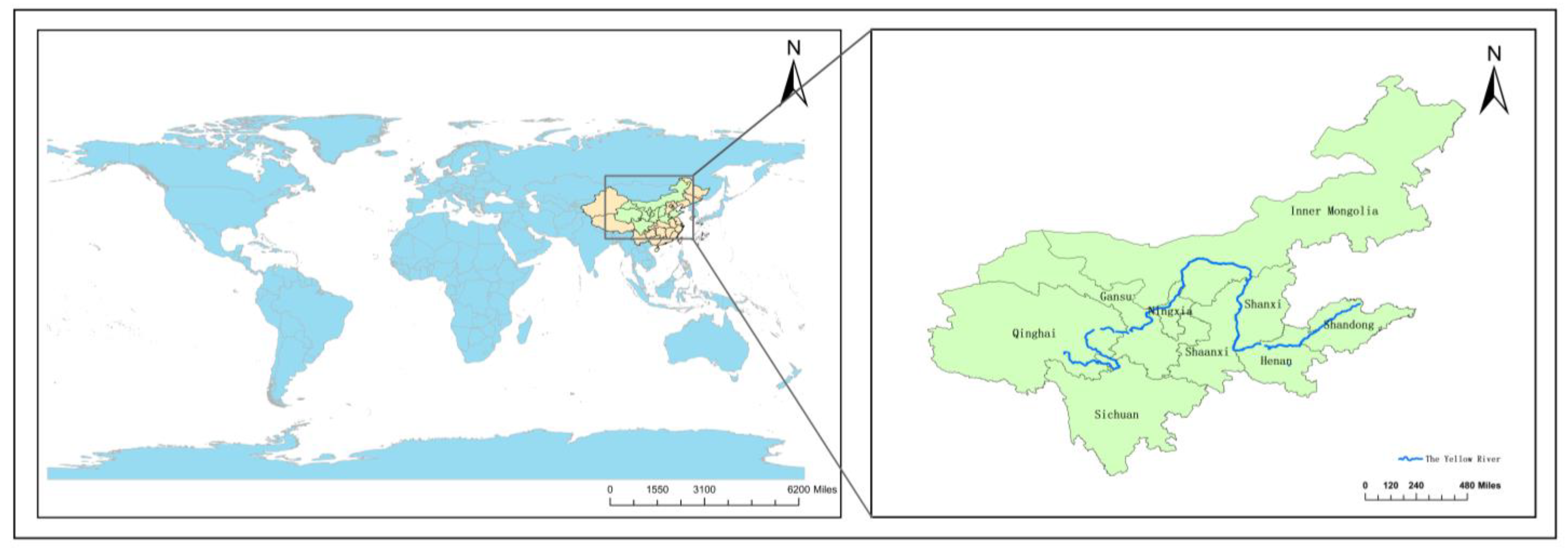
Figure 1. Schematic diagram of the location of administrative regions in the YRB.
Sustainability 15 12270 g001
Figure 2. Research Framework.
Sustainability 15 12270 g002
Figure 3. Conceptual diagram of the interaction between the HQDU and the WRS.
Sustainability 15 12270 g003
Figure 4. The Changing Trend of the Comprehensive Development Indices of the HQDU and the WRS in the YRB.
Sustainability 15 12270 g004
Figure 5. Heat Map of the Comprehensive Development Indices of HQDU and WRS in the YRB in Each Province.
Sustainability 15 12270 g005
Figure 6. The Comprehensive Development Index of the Subsystems of HQDU and Water Resources.
Sustainability 15 12270 g006
Figure 7. Coupling Coordination Degrees of the YRB from 2010 to 2021.
Sustainability 15 12270 g007
Figure 8. Coupling Coordination Levels in the Provinces of YRB.
Sustainability 15 12270 g008aSustainability 15 12270 g008bSustainability 15 12270 g008c
Figure 9. Clustering Map of CCD Among Provinces in the YRB.
Sustainability 15 12270 g009
Figure 10. Clustering Diagram of CCD in the YRB.
Sustainability 15 12270 g010
Table 1. Indicator System of the HQDU in the YRB.
SubsystemIndicatorSymbolsUnitsAttributesMeaningOrigin
InnovationR&D investment intensity A 1 %PositiveR&D expenditure/total GDP[21]
Per capita investment in science and technology A 2 YuanPositiveThe average expenditure of each person in the regional general public budget expenditure in science and technology[22]
Per capita education investment A 3 YuanPositiveThe average expenditure of each person in the regional general public budget expenditure on education [22]
Technology market turnover as a percentage of GDP A 4 %PositiveTechnology market turnover/total GDP[23]
Innovative product profitability A 5 %PositiveInnovative product sales revenue/industrial enterprise main business revenue[1]
Number of students in higher education per 100,000 people A 6 PersonPositiveNumber of students in higher education × 100,000/total population[1]
Number of patent applications granted per 10,000 people A 7 PiecePositiveNumber of patents granted × 10,000/total population[21]
CoordinationIU ratio A 8 NoneModerateLabor industrialization rate/urbanization Rate[1]
NU ratio A 9 NoneModerateLabor non–agriculturalization rate/urbanization rate[1]
Coordination Index of Urbanization Economic Growth Speed A 10 NonePositiveThe average annual growth rate of urbanization rate/Average annual growth rate of per capita GDP[24]
The proportion of tertiary industry in the GDP A 11 %PositiveTertiary industry output value/total GDP[25]
Total dependency ratio A 12 %NegativeNon–working–age population/working–age population in the total population[26]
Urban–rural income level ratio A 13 %NegativeDisposable income per capita in urban areas/disposable income per capita in rural areas[23]
Urban–rural consumption level ratio A 14 %NegativeUrban per capita consumption expenditure/rural per capita consumption expenditure[23]
Urbanization rate A 15 %PositiveUrban population/total population[27]
GreenPer capita emissions of main pollutants in the exhaust gas (sulfur dioxide + nitrogen oxides + smoke (dust)) A 16 t/personNegativeMain pollutants (sulfur dioxide, nitrogen oxides, and smoke (dust) emissions) in exhaust gas/total population[21]
Harmless treatment rate of domestic garbage A 17 %PositiveThe amount of domestic garbage treated in a harmless manner/the amount of domestic garbage generated[28]
Urban domestic sewage treatment rate A 18 %PositiveUrban domestic sewage treatment volume/Urban domestic sewage generation volume[29]
The comp utilization rate of general industrial solid waste A 19 %PositiveThe amount of solid waste extracted from general industrial solid waste or converted into usable resources, energy apprehensive other raw materials/amount of general industrial solid waste generated[20]
Green coverage rate in the built–up area A 20 %PositiveThe coverage area of urban built–up area/area of urban built–up area[29]
OpennessForeign investment openness A 21 %PositiveTotal foreign investment/total GDP[30]
Foreign trade dependence A 22 %PositiveTotal import and export/total GDP[31]
Actual utilization of foreign capital as a proportion of GDP A 23 %PositiveTotal actual utilization of foreign capital/total GDP[32]
SharingNumber of health technicians per thousand people A 24 PersonPositiveNumber of health technicians × 1000/total population[33]
Number of public transport vehicles per 10,000 people A 25 VehiclesPositiveNumber of public transportation vehicles × 10,000/total population[34]
Per capita possession of public library collections A 26 Book/personPositivePublic library collections/total population[9]
Urban basic pension insurance participation rate A 27 %PositiveNumber of people participating in urban basic endowment insurance/total population[35]
Urban registered unemployment rate A 28 %NegativeUrban registered unemployed persons/(Urban employed persons + urban registered unemployed persons)[36]
GDP per capita A 29 Yuan/personPositiveTotal GDP/total population[34]
Table 2. Indicator System of WRS in the YRB.
SubsystemIndicatorSymbolsUnitsAttributesMeaning Origin
Background conditions of water resources Total water resources B 1 108 m3PositiveThe amount of surface and underground water produced by precipitation[11]
Water resources per capita B 2 m3/personPositiveIn a region, the average amount of water resources possessed by each person in a certain period[37]
Total urban water supply B 3 108 tPositiveThe total amount of water supplied by the water supply unit[38]
Water resource utilization capacityWater consumption per capita B 4 m3/personNegativeThe average amount of water resources possessed by each person in a region in a certain period[39]
Water consumption per 10,000–yuan GDP B 5 m3/104 yuanNegativeTotal water consumption/GDP[37]
Water consumption per unit of industrial–added value B 6 m3/
104 yuan
PositiveAnnual water consumption/industrial added value[11]
Water resources management levelComprehensive production capacity of water supply B 7 104 m3/dayPositiveComprehensive production capacity is calculated based on the design capacity of water supply facilities such as water intake, purification, water delivery, and the ex–factory water transmission trunk pipes[40]
Urban drainage pipe length B 8 104 kmPositiveRefers to the sum of the lengths of all main drainage pipes, trunk pipes, branch pipes, inspection wells, connecting well inlets and outlets, etc.[41]
City water supply pipeline length B 9 kmPositiveRefers to the length of all pipes from the water pump to the user’s water meter[42]
Water pollution controlTotal wastewater discharge B 10 104 tNegativeWastewater discharge refers to the amount of water discharged by water users such as industry, tertiary industry, urban residents, etc.[14]
Cod B 11 104 tNegativeUnder acidic conditions, the amount of oxygen consumed to oxidize organic matter to CO2 and H2O with a strong oxidant[14]
The daily treatment capacity of urban sewage B 12 104 m3PositiveRefers to the design capacity of the sewage treatment plant to treat sewage per day and night[42]
Table 3. Mean Random Coincidence Index.
n 1234567891011
R I 000.580.901.121.241.321.411.461.491.52
Table 4. Classification Table of Coupling Degrees.
Coupling DegreeCoupling TypeFeature
0–0.29Low coupling stageThe two subsystems start to play a game, and the coupling degree is at a low level.
0.3–0.49Antagonistic stageThe interaction between the two subsystems is strengthened, the dominant subsystem begins to occupy the space of the other subsystems, and the other subsystem continues to decline continually.
0.5–0.79Run–in stageThe two subsystems balance and cooperate with each other, showing benign coupling characteristics.
0.8–1Coordinated coupling stageThe two subsystems become more coupled and gradually develop toward an orderly direction, and are in a period of high–level coupling coordination.
Table 5. Classification Table of CCD.
TypeDGradeThe Relationship between S1 and S2Specific Description
Disorder recession0–0.09Extreme imbalanceS1 > S2Backward WRS type
S1 < S2Backward HQDU type
S1 = S2Synchronization of HQDU and WRS type
0.1–0.19Serious imbalanceS1 > S2Backward WRS type
S1 < S2Backward HQDU type
S1 = S2Synchronization of HQDU and WRS type
0.2–0.29Moderate DisorderS1 > S2Backward WRS type
S1 < S2Backward HQDU type
S1 = S2Synchronization of HQDU and WRS type
Transition class0.3–0.39Mild disorderS1 > S2Backward WRS type
S1 < S2Backward HQDU type
S1 = S2Synchronization of HQDU and WRS type
0.4–0.49On the verge of disorderS1 > S2Backward WRS type
S1 < S2Backward HQDU type
S1 = S2Synchronization of HQDU and WRS type
0.5–0.59Barely coordinationS1 > S2Backward WRS type
S1 < S2Backward HQDU type
S1 = S2Synchronization of HQDU and WRS type
0.6–0.69Primary coordinationS1 > S2Backward WRS type
S1 < S2Backward HQDU type
S1 = S2Synchronization of HQDU and WRS type
Coordinated development category0.7–0.79Intermediate coordinateS1 > S2Backward WRS type
S1 < S2Backward HQDU type
S1 = S2Synchronization of HQDU and WRS type
0.8–0.89Good coordinationS1 > S2Backward WRS type
S1 < S2Backward HQDU type
S1 = S2Synchronization of HQDU and WRS type
0.9–1High–quality coordinationS1 > S2Backward WRS type
S1 < S2Backward HQDU type
S1 = S2Synchronization of HQDU and WRS type
Table 6. Obstacle Degrees of Subsystems in the Two Systems.
SystemHigh–Quality Development of Urbanization SystemWater Resources System
SubsystemInnovationCoordinationGreenOpennessShareBackground
Conditions
Utilization
Capacity
Management
Level
Pollution
Control
201035.56%25.70%9.25%11.20%18.30%28.56%8.86%49.14%13.44%
201134.71%24.02%12.03%12.29%16.95%18.89%5.34%31.81%43.96%
201233.97%24.87%11.28%13.56%16.32%17.70%6.41%30.14%45.75%
201333.34%24.67%11.70%14.94%15.35%17.42%6.16%28.74%47.67%
201436.16%20.28%12.52%15.64%15.40%19.62%4.40%24.79%51.19%
201539.32%18.55%14.40%16.17%11.56%21.24%5.75%22.51%50.49%
201640.79%21.49%10.94%15.66%11.13%22.34%6.52%24.83%46.31%
201738.61%23.94%12.60%14.02%10.83%21.04%6.46%23.22%49.29%
201832.09%27.21%13.40%17.17%10.13%18.49%6.41%24.47%50.62%
201936.69%30.39%13.29%11.90%7.72%20.98%6.41%12.91%59.70%
202032.36%34.30%11.48%12.55%9.31%18.30%5.12%8.81%67.77%
202113.17%47.52%10.90%17.88%10.53%12.53%4.08%8.29%75.10%
Table 7. The Dominant Obstacle Indicators in the Two Systems.
The HQDUThe WRS
Ranking1234512345
2010A4A10A21A5A7B7B3B8B12B9
2011A4A10A21A5A7B10B7B11B3B8
2012A21A10A4A5A7B10B7B11B3B8
2013A21A4A10A5A7B10B7B11B3B4
2014A21A4A5A10A7B10B7B11B3B2
2015A4A21A5A7A16B10B7B11B3B2
2016A5A4A21A10A7B10B7B3B2B1
2017A10A4A7A5A21B10B7B3B2B1
2018A10A21A7A4A5B10B7B3B4B2
2019A10A4A7A19A5B10B11B7B3B2
2020A10A4A19A7A23B10B11B3B7B4
2021A10A19A23A21A4B10B11B7B3B4
Disclaimer/Publisher’s Note: The statements, opinions and data contained in all publications are solely those of the individual author(s) and contributor(s) and not of MDPI and/or the editor(s). MDPI and/or the editor(s) disclaim responsibility for any injury to people or property resulting from any ideas, methods, instructions or products referred to in the content.