Article

Geophysical Prospecting of the Coptic Monastery of Apa Moses Using GPR and Magnetic Techniques: A Case Study, Abydos, Sohag, Egypt

by
Abdelbaset M. Abudeif
1,*,
Gamal Z. Abdel Aal
2,
Hatem S. Ramadan
3,
Nassir Al-Arifi
4,
Stefano Bellucci
5,
Khamis K. Mansour
6,
Hossameldeen A. Gaber
1 and
Mohammed A. Mohammed
1
1
Geology Department, Faculty of Science, Sohag University, Sohag 82511, Egypt
2
Geology Department, Faculty of Science, Assiut University, Assiut 71515, Egypt
3
Faculty of Earth Science, Beni-Suef University, Beni-Suef 62511, Egypt
4
Geology and Geophysics Department, College of Science, King Saud University, Riyadh 11451, Saudi Arabia
5
INFN—Laboratori Nazionali di Frascati, 00044 Frascati, Italy
6
National Research Institute of Astronomy and Geophysics (NRIAG), Helwan 11421, Egypt
*
Author to whom correspondence should be addressed.
Sustainability 2023, 15(14), 11119; https://doi.org/10.3390/su151411119
Submission received: 29 March 2023 / Revised: 31 May 2023 / Accepted: 1 June 2023 / Published: 17 July 2023

Abstract

:
As a result of new discoveries, there is a greater opportunity for development and investment in the Al-Arraba EL-Madfuna region of Abydos, Sohag Governorate, Egypt, which benefits tourism and increases the national economy. The Coptic monastery, which was originally established by Apa Moses, the patriarch of the Coptic Church during the ancient Roman Empire, has vanished inside the current market on this site, along with numerous tombs. As a result, the primary goal of this work is to prospect on this site for these potential archaeological features. Ground magnetic and ground-penetration radar (GPR) surveys were employed for discovering these archaeological issues. This work was done in coordination with the Supreme Council of Antiquities. Ground magnetic and GPR surveys were implemented using the G-857 proton-precession magnetometer and GSSI SIR 4000 with a 200 MHz antenna. The data were processed and interpreted using Geosoft Oasis Montaj and REFLEXW v.5.8 software packages. The magnetic data were filtered to separate the shallower anomalies representing the archaeological remains from those of the deeper ones. Butterworth high pass filter, first vertical derivatives, analytical signal, and tilt derivative were employed to carry out the processing stages. The results were analyzed qualitatively and quantitatively to describe these anomalies and determine their locations, geometrical shapes, and depths. The source parameter imaging technique and 3D Euler deconvolution were used to calculate the depths. The analysis of magnetic maps shows that the study site is characterized by a number of anomalies that occur and have geometric squares and rectangle shapes with depths ranging from 0.7 m to ≈4 m. Some of these anomalies are related to potential archaeological objects. GPR findings reveal considerably scattered hyperbolas along several profiles, which may indicate the presence of potential buried objects. The integration of magnetic and GPR results showed that there is some consistency in the identification of the locations of the likely buried archaeological objects and their depths (0.7 to 3 m) for the majority of the discovered targets. The findings of this study suggest excavating at this location and relocating the market in order to protect the buried antiquities from being lost to be safeguarded as a tourist destination target.

1. Introduction

Over the centuries, Abydos developed as a cultural and, most importantly, religious center: the cult of Osiris played an important role. The archaeological site of Abydos is the most prominent burial ground for kings and top court officials in ancient Egypt, so this site is given strategic importance and tourist attraction. One of the most famous places to be buried in ancient Egypt for monarchs and top court officials was the Abdju site (the original name of the modern Abydos), where the early pharaohs were laid to rest. Additionally, it serves as the location of several ancient temples, including the royal necropolis. Due to its connections to Osiris’ religion and the preferred resting places for the earliest and oldest monarchs, including Seti I and Ramses II, the city of Abydos rose to become Egypt’s most revered region [1]. The difficulty with this study in this location is attributed to its strategic engineering value, as it is an ancient site with both explored and unknown elements where new facilities are likely to be built. The Abydos site is the focus of the majority of archaeologists since it is one of the oldest and most important archaeological sites with enormous social, historical, and cultural value. It is famous in the history of ancient Egypt due to its extensive archaeological contents, such as the royal necropolis, the tomb of Umm El-Qa’ab, the Temple of Seti I, and the Temple of Ramses II. Damarany and Abdallah from Egypt’s Supreme Council of Antiquities (SCA) conducted excavations in the marketplace south of Abydos between April 2009 and April 2013, and found some architectural construction remnants and ceramic material [2]. The phases of discovery and cultural growth are reflected by the finding of Egyptian archaeology at the Abydos site [2]. As a result, numerous Egyptian and foreign archaeological missions investigated some of these places to preserve and date artifacts; some of these investigations are still ongoing [2,3,4]. Excavations are required for ancient archaeological explorations, which require more time, effort, and money, and they have a negative impact on the loss of significant antiquities. As a result, the advancement of modern geophysical methods aids in the accurate and rapid exploration of buried antiquities while protecting them from damage.
From the historical background of this site and the previous works of different authors, the investigation site was carefully chosen because of having numerous unidentified tombs as well as a Coptic monastery dating back to the 5th century CE and later. This monastery was established by Apa Moses, the patriarch of the Coptic Church. Numerous Roman-period artifacts were discovered during excavations at the site, particularly in its eastern portion [5,6]. Therefore, the main objective of this work is to discover this buried Coptic monastery and any other tombs within this site. To achieve this goal, an integration of two geophysical tools (ground magnetic and ground-penetrating radar techniques) was applied to survey the south Abydos marketplace to determine the locations, geometrical shapes, sizes, and depths of buried archaeological objects. The outcomes of this work can be used as guides during the excavation procedure.
The ground magnetic survey depends on the variations in the magnetic properties of an object of interest and its surroundings. Magnetization and magnetic susceptibility are the two essential magnetic parameters for archaeological study. The majority of artifacts contain magnetic elements, which have magnetic characteristics and enable them to produce magnetic anomalies that can be used in a variety of ways. The various compositions of the remains and the surrounding soil may allow the created total magnetic intensity map to follow changes in the strength of the Earth’s magnetic field. Depending on how magnetically sensitive the rock is, magnetic anomalies can either be positive or negative [7,8].
Ground-penetrating radar (GPR) is utilized for imaging the earth’s shallow subsurface, as well as the archaeological objects, roadways, and construction materials. It can give exact depth for a variety of subsurface features [9]. For archaeological studies, GPR is frequently employed. It is quick and enables the archaeologist to thoroughly cover a large area while obtaining high-resolution images of hidden archaeological features. The success of GPR surveys in archaeology depends significantly on the soil, clay content, sediment mineralogy, depth of burial, ground moisture, surface topography, and vegetation [9].
Several authors prospected archaeological features at various ancient locations for historical studies, using either magnetic or GPR methods or both. Land magnetic and GPR techniques in other sites in Abydos city were used to discover buried archaeological features [7,10,11,12,13,14,15,16,17,18,19]. Their results reveal eight distinct anomalies which may indicate the possibility of probable buried archaeological objects ranging from 2 to 4 m depth. The magnetic method was applied in Abydos city near this site [7,10,11,12,13,14,15,16,17,18,19] and recognized high magnetic anomalies which may be interpreted as archaeological features of mud brick, ranging in size and depth from 3 m to 12 m and 1 to 5 m, respectively. These techniques were used by researchers in other countries to find the depths of buried archaeological targets. The combined findings of these techniques reveal that most of the potential buried archaeological targets were mapped in accordance with the depths [7,10,11,12,13,14,15,16,17,18,19]. Additionally, these techniques were utilized in conjunction with other techniques such as electrical resistivity tomography (ERT) and MASW to detect the subsurface archaeological objects [20,21,22]. The external sectors of the Castle of Melfi in Italy were investigated by Leucci et al. using GPR and ERT Surveys. The findings showed the presence of anomalies in the initial subsoil layers, although they generally persist to deeper levels exceeding 1.50 m. The key features for mapping the geometry of the buried mud-brick walls and providing useful information for reconstructing the archaeological context of the site were the sharp and vertical contact of the buried walls and the contrast between the archaeological clay-rich layer and the basal sands [10] where these authors used GPR and ERT surveys as enhanced imaging of archaeological ruins in the Nile Delta, Egypt. To find near-surface caves in the Duqm region of Oman, Mohamed et al. used GPR, ERT, and MASW. The findings reveal two cavern systems with various thicknesses. Although the caves are divided at the top, occasionally—especially when moving north—they merge into a single cavern system. The cavern system is not entirely hollow; in some places, they are filled with materials having characteristics distinct from those of the host rock. The cavern system has varying depths between 0 and 5.2 m. The GPR method has continued to advance, enabling researchers in a variety of fields to obtain high-resolution images of subsurface objectives, including those in geology and civil engineering [23,24,25], management and conservation of the cultural heritage [26], and archaeology [27,28,29], in examining frescoes, decorations, and columns [23,30,31,32], and in describing ground conditions in urban areas [33].

2. Location Map and Description of the Study Area

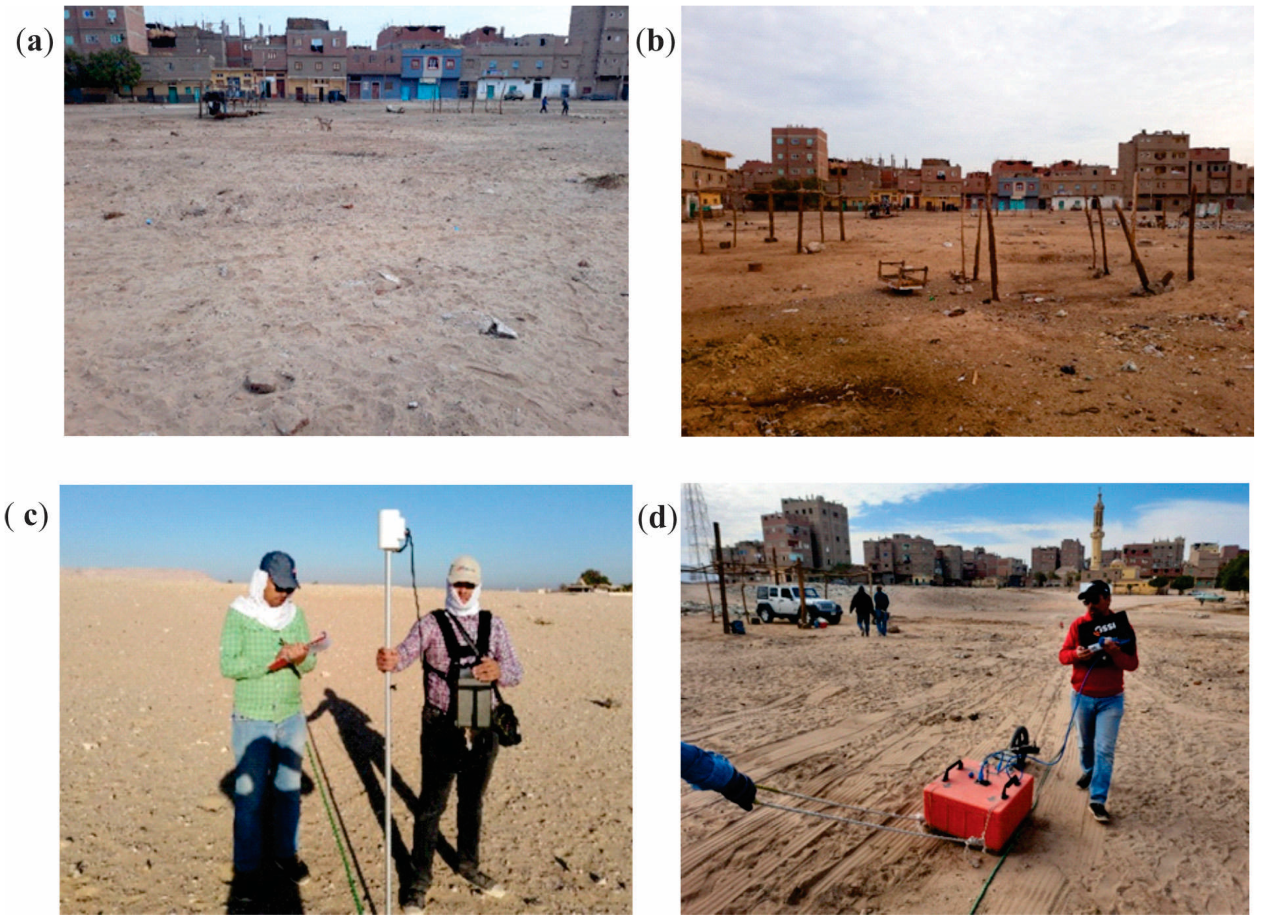
The study site is a part of the Abydos archaeological site, which is 13 km west of El-Balyana city in Sohag, Egypt, and positioned west of the Nile River. The study area is located between latitudes 26°10′49″ N and 26°10′54″ N and longitudes 31°55′15″ E and 31°55′24″ E (Figure 1). The archaeological site is inside the marketplace in the community of Al-Arraba; this is situated on an empty land south of Abydos (Figure 2). This land was leveled by the inhabitants, which is totally covered by sand and clay deposits to hold the market twice a week (on Saturdays and Tuesdays). The land is primarily flat, but the ground level is higher in its western end than in its center and eastern regions, with a little slope running down from west to east. The marketplace location is approximately 500 m south of the Seti I temple and 1500 m east of the Umm Al-Qa’ab ancient royal cemetery.

3. Archaeological Background

The city of Abydos has played an important role in the cultural development of ancient Egypt throughout its history. Royal and nonroyal individuals alike attempted to link their funerary cults with that of the god Osiris, ruler of the underworld, centered at North Abydos during the pharaonic era. Abydos was at the heart of cultural change once more during the latter Coptic period, however, as the new monotheistic religion fought with the nation’s pagan heritage. There is a good chance that the unknown monument founded by Apa Moses, the head of the Coptic church, is the location of the Coptic monastery whose pottery dates from the 5th century CE. However, this structure also had a fascinating window into a convoluted period of previous pharaonic history within its confines [4]. According to Apa Moses’ history, the renowned church figure known as Apa Shenoute predicted on his deathbed that a strong new monastic leader would emerge soon and finish the elimination of pagan institutions from Upper Egypt [34,35]. This monastic ruler was born in 470 CE and named Apa Moses. Documents praise Moses as a capable and inspirational monastic leader, but up to this point, modern archaeological research has been unable to locate the actual remnants of a Late Antique monastery at Abydos associated with Moses’ name where Late Antique Egypt ran from the reign of the Roman emperor Diocletian (284–305 CE) to the Arab conquest of Egypt (641 CE) [34,36]. The majority of researchers have come to the conclusion that the small object known as Apa Moses’ monastery might have originally been located in the contemporary Coptic church at south Abydos, which is dedicated to El-Sitta Damiana and the Forty Virgins [2,4,37].

4. Geological Setting

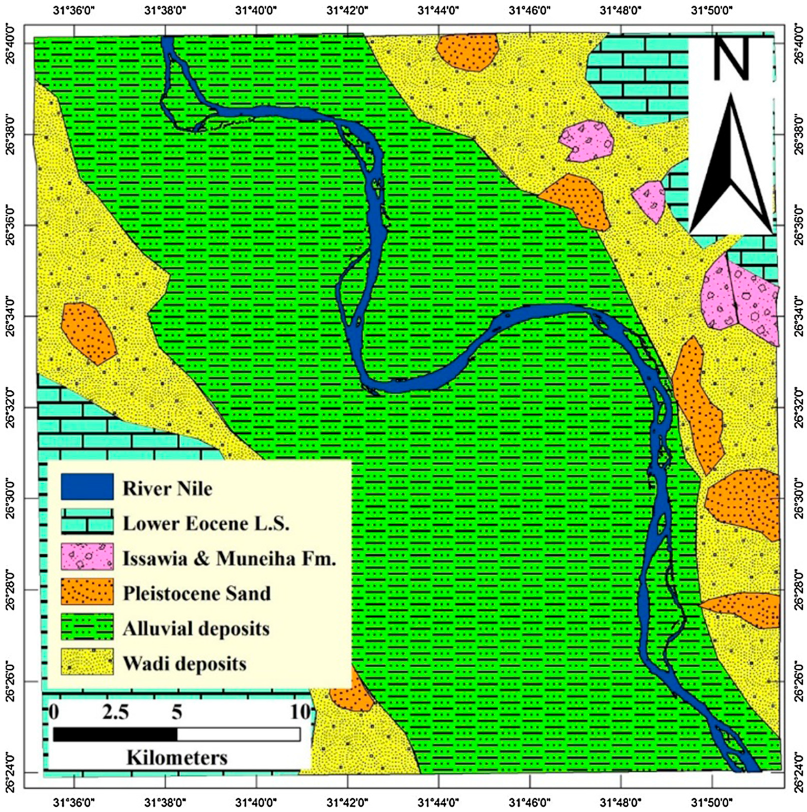
According to lithology, the many rock units found across the Sohag area are all made up of sedimentary sequences (Figure 3) that range in age from Lower Eocene to Recent [18,38]. Table 1 lists the major rock units in the studied site. Ahmed [39] asserts that a number of movements at various periods had an impact on the ground, resulting in the buildings that are present in the area southwest and west of Sohag. The Eocene plateau in the Nile valley is influenced by normal faults, strike-slip, and folds that exhibit tensional forces rather than compressional forces [40,41]. According to Youssef [42], faults typically follow the NE-SE (Gulf of Suez trend), NE-SW (Aqaba trend), and E-W trends (transverse trend).

5. Materials and Methods

Ground magnetic and GPR methods are near-surface geophysical tools that were commonly applied in the investigation of the proposed archaeological site. Furthermore, the provided information from the Egyptian Antiquities Authority was collected from the reports of interior and exterior archaeological missions on the Abydos site. The geological and geophysical data about this site were gathered.

5.1. Magnetic Method

The shallow subsurface archaeological remains such as tombs, buried entrances, bricks, buried walls, and constructions can be mapped using the magnetic method, which is nondestructive, quick, and reliable. This technique concentrates mainly on the identification of magnetic minerals, particularly magnetite, present in archaeological components. It is common knowledge that most artifacts made of clay and mud contain a high concentration of magnetized materials, varying in percentage according to sedimentation circumstances and construction techniques. These materials are crucial for magnetic exploration in archaeology due to the clear distinction between these minerals and their environment [43,44,45,46].
In this survey, two Geometrics 857 proton precession magnetometers were used to conduct a ground magnetic survey, one as a base station instrument and the other as a field station instrument.
They have a precision of 0.5 nT and a high resolution of 0.1 nanotesla [47]. The data were corrected from diurnal variations of the earth’s magnetic field. Three blocks, A, B, and C, that constitute this site were surveyed (Figure 1). The block sizes of A, B, and C are 85 m × 70 m, 100 m × 100 m, and 100 m × 65 m, respectively. The surveyed lines in each block were measured in the NW-SE direction with line spacing and station intervals of 5 m producing 18, 21, and 14 lines for blocks A, B, and C, respectively. The total numbers of the measured stations are 987, and their locations were determined using Garmin 64 GPS. The Oasis Montaj Software package v. 8.4. was utilized for the processing and interpretation of the magnetic data [48]. The final output of the surveyed magnetic data after correction is the total magnetic intensity (TMI) anomaly map. Several processing and analysis techniques were applied to the TMI data. Different filters, including the Butterworth high pass filter, apparent magnetic susceptibility, first vertical derivatives, tilt derivative, and analytical signal, were used to carry out the processing processes for qualitative interpretation. Depth estimation techniques, such as source parameter imaging and 3D Euler deconvolution with structure indices 1 and 2, were applied to identify the depth of the buried archaeological objects.

5.2. Ground-Penetrating Radar (GPR) Method

GPR is a successful geophysical method that can make high-resolution subsurface imaging of buried objects. When using this method, radar waves are transmitted and received from a bistatic or monostatic antenna. These waves will reflect from the underground discontinuities, and the two-way travel times are determined. Using the appropriate velocity of the subsurface materials, the depth of these materials can be determined. Radargram sections can be converted into meaningful two-dimensional or three-dimensional images by utilizing advanced data processing [49,50].
The GPR instrument of GSSI-SIR-4000 was employed in the current survey. To choose the best antenna, according to the exposed archaeological objects in this site and the former background about the target’s depth, a monostatic 200 MHz antenna was employed in this study to provide good vertical resolution and accurate depth estimation of the buried objects. A GSSI surveyed wheel type 620 with a 16-inch diameter was attached to the antenna to measure the moved distance.
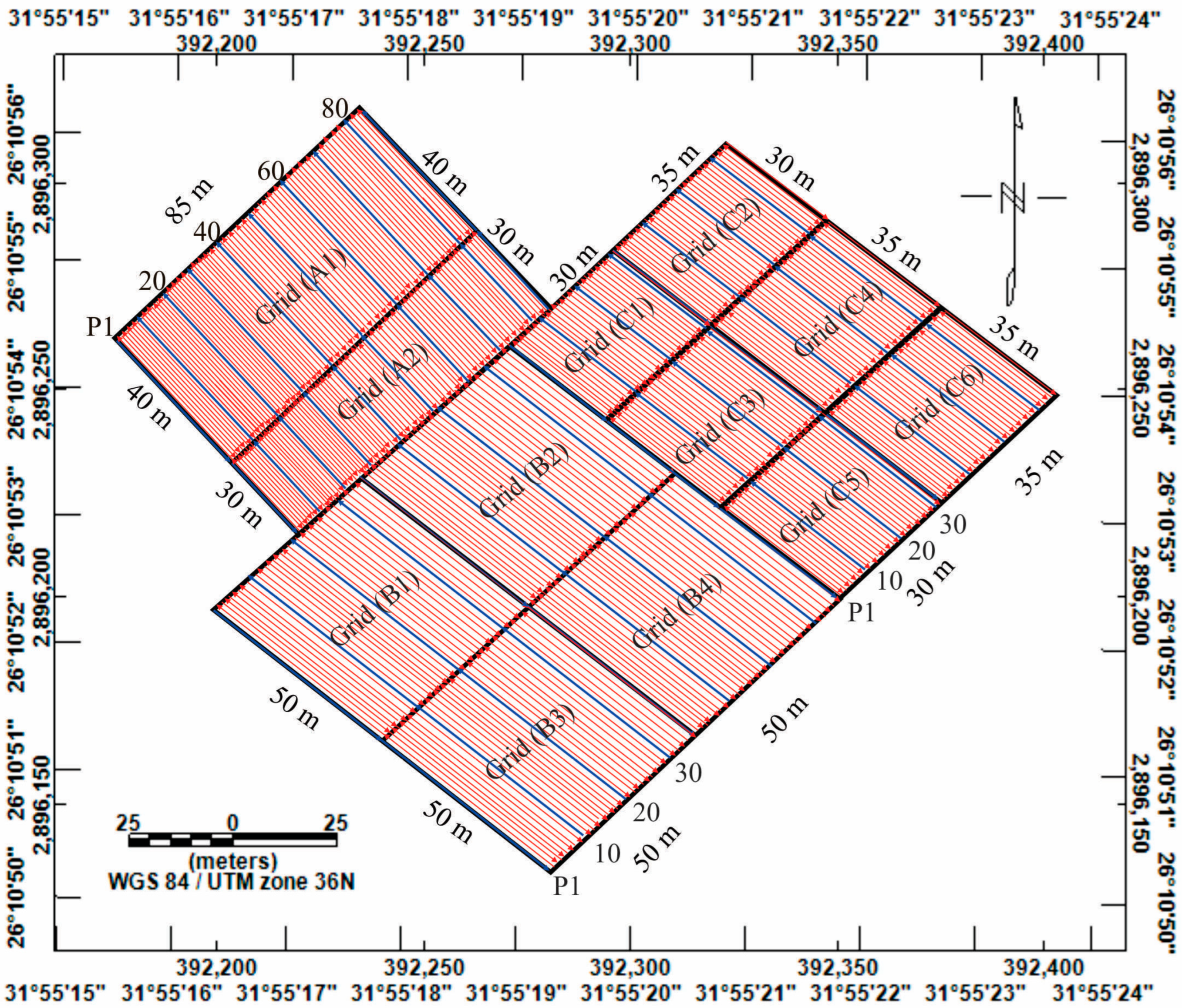
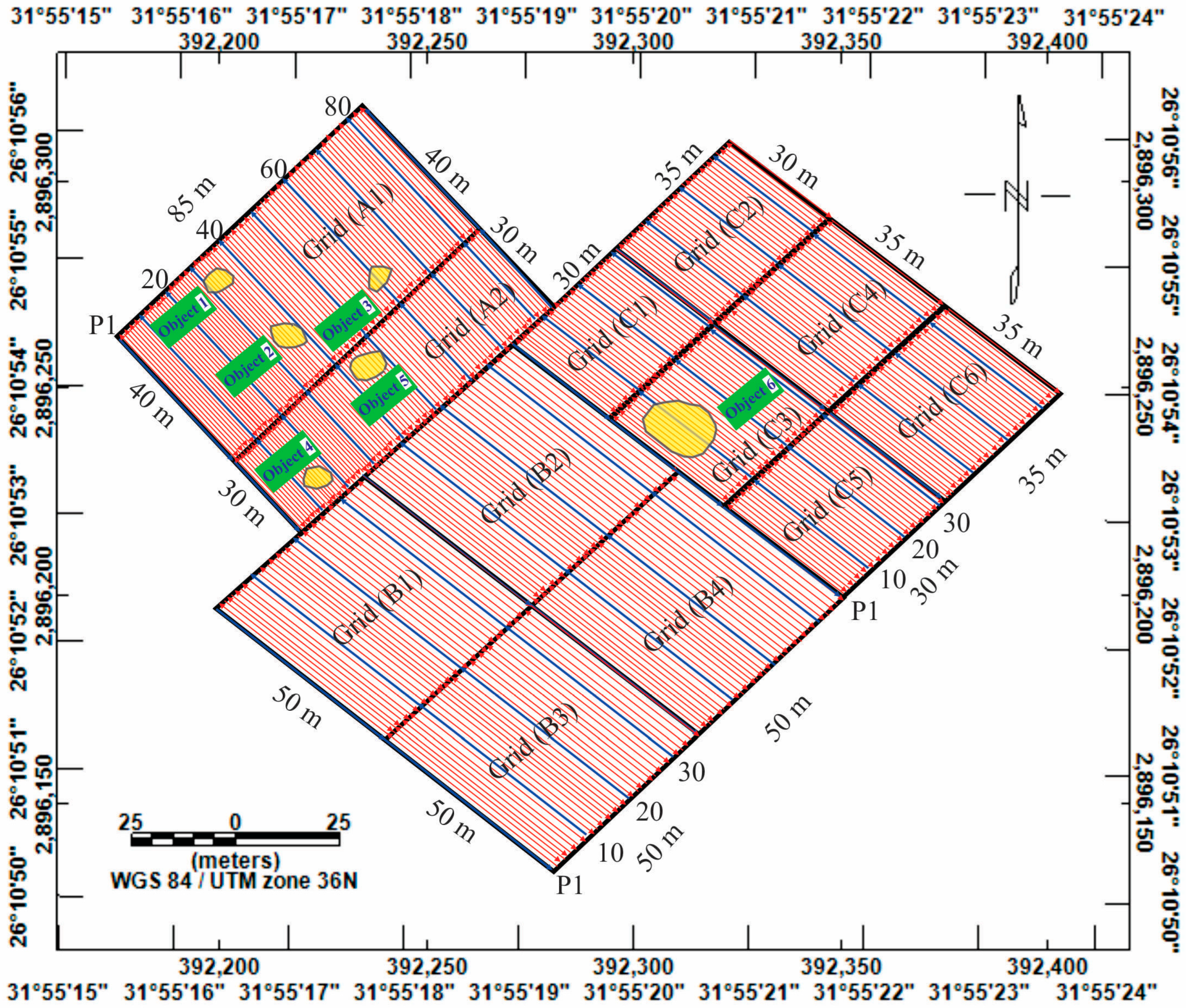
Each block of the previous three magnetic blocks was divided into small blocks according to the accessibility of the location to produce twelve small blocks (Figure 4). Block (A) provided two small blocks (A1 and A2 with dimensions of 40 × 85 m and 30 × 85 m). Block (B) provided four equal blocks (B1 to B4 with a dimension of 50 × 50 m). Block (C) provided six unequal small blocks (C1 with a dimension of 30 × 30 m, C2, C3, and C5 are 35 × 30 m, and C4 and C6 are 35 × 35 m). Comprehensive GPR surveys were implemented on all these blocks using a monostatic 200 MHz central frequency antenna in a zig-zag configuration in the NE-SW direction. A total of 86 profiles were surveyed on block A1 with 40 m profile length, and other 86 profiles were surveyed on block A2 with 30 m profile length; the profile spacing is 1 m, producing 172 profiles. A total of 35 profiles with a profile length of 50 m and a profile spacing of 1.5 m were surveyed on the blocks from B1 to B4 producing 140 profiles. The profile lengths of C1 and C2 blocks are 30 m, while those for C3–C6 blocks are 35 m, and profile spacing in these blocks is 1 m, producing 201 profiles. Thus, the total number of all surveyed profiles in all blocks is 513 profiles.
After data acquisition, processing GPR data is a crucial step. It cleans the raw data of any background noise and undesired reflections that may be created by the antenna, variations in the coupling of energy with the ground, and simultaneous reflections between the antenna and the ground surface [26]. To clarify the high reflections and identify potential artifacts in the study area, GPR data were analyzed using REFLEXW v.5.8 Software utilizing various filters and criteria [51]. The measured data were subjected to several processing phases, including subtract mean, static correction, background removing filter, gain, bandpass frequency, energy decay filter, running average, time cut, subtracting average, trace interpole 3D, X-flip, and time-depth analysis, where the velocity employed to transform the time to depth (V = 0.105 m/ns) gives a good resolution for the desired depth. In this work, both the reflected wave procedure and the hyperbolic shape way were used to determine the radar wave’s velocity.

6. Results and Discussion

6.1. Magnetic Data Interpretation

Identification of the subsurface sources of the potential archaeological targets and estimation of their shapes within the studied site are the fundamental aspects of the interpretation of magnetic maps. The TMI anomaly map and its derivatives were interpreted qualitatively and quantitatively.

6.1.1. Total Magnetic Field Intensity (TMI) Map

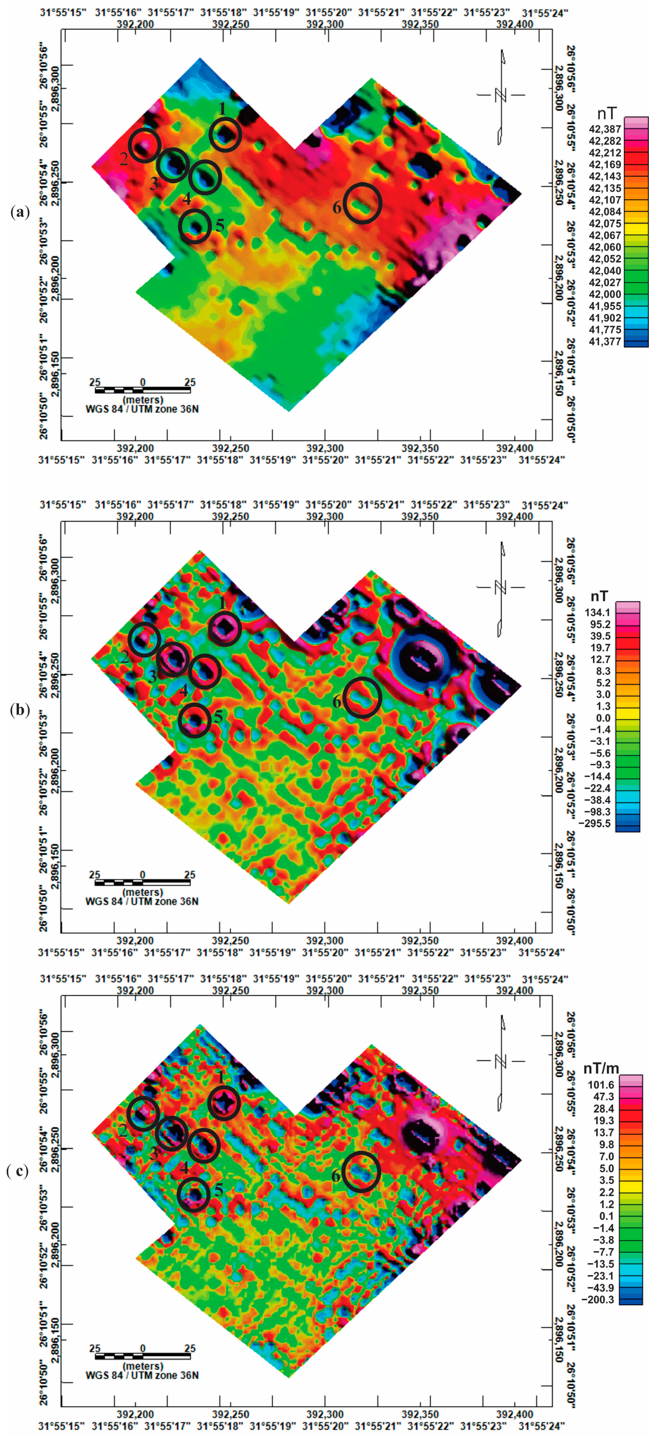
The TMI anomaly map showed different types of anomalies of deeper and shallower objects. To identify the potential location of these objects, the TMI map must be separated into a low-pass map of deeper origin sources and a high-pass map of shallower sources that may represent archaeological remains. The TMI map reveals a group of anomalies with low and high intensities that are dispersed in designated locations and have rectangular and square shapes with diameters ranging from 5 m to approximately 7 m. TMI values vary from 41,377 nT to a maximum value of 42,387 nT (Figure 5a). Comparing blocks (A) and (B), block (C) has considerably greater magnetic values. High concentrations of waste, including iron materials, granitic boulders, and burned materials, are present in Block (C) at this location. It is a location for marketing in El Araba Village. Some locations in this block have magnetic values of greater than 42,280 nT along the east and west boundaries of the mapped area. The eastern and western boundaries of the site are quite close to the wall of El Araba’s school and are above the animal wastes, respectively, explaining why the magnetic values are increasing more rapidly in this location.

6.1.2. Butterworth High Pass (HP) Residual Map

The TMI anomaly map was processed using a Butterworth high pass filter with a degree of filter function of 8 and a cut-off wavelength of 25 m to produce an HP residual map. Careful inspection of the HP map (Figure 5b) showed that the magnetic values vary from −295.5 nT to 134.1 nT. High and low anomalies of shallow sources are visible on this map. At various places, these anomalies are square or rectangular in shape and range in diameter from 5 to 7 m. These anomalies may be attributed to potential archaeological objects.
From the excavation of the adjacent archaeological remains within the investigated site, the buried objects that caused these anomalies are formed from multichambered mud-brick tombs of various sizes and forms of high magnetic susceptibility which were disturbed throughout time and were later replaced with low magnetic materials like sands; this conclusion is in consistent with the opinion of author [52] in another archaeological site. Thus, the magnetic values of the outer margins of the anomalies are higher than the magnetic values of the inner cores of these anomalies. These findings are extremely consistent with the results of the other archaeologists who worked near this site.

6.1.3. First Vertical Derivative (FVD) Map

Locations of the existing anomalies are illustrated in excellent detail in Figure 5c. The contacts between the magnetic anomalies are provided by the zero contour lines in this map, which outline the magnetic sources and highlight the connections between highly polarized and less polarized anomalies. The FVD map showed that the positive values reach up to 101.6 nT/m, while the negative ones are −200.3 nT/m.

6.1.4. Analytical Signal (AS) Map

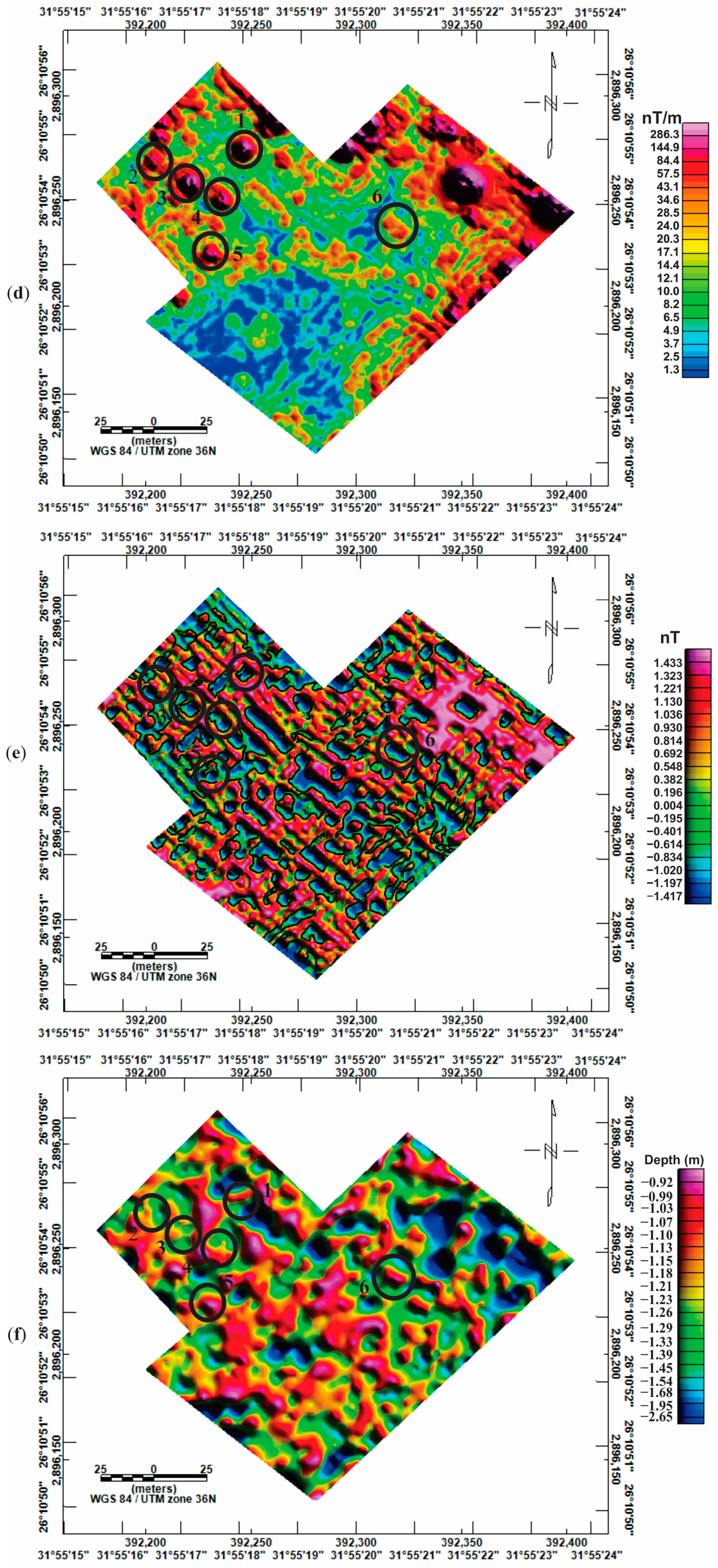
Examination of the analytical signal map (Figure 5d) reveals significant gradient peaks that coincide with those predicted by the Butterworth high pass filter. The analytical signal values are between 1.3 to 286.3 nT/m. With an average radius between 5 and 10 m, most high analytical signal anomalies have rectangular and square geometrical shapes. The shallow sources in this site are reflected in sharp gradient peaks. Several very high anomalies with an average diameter of 5 m are dispersed across the block (A). Most of the anomalies in block (B) exhibit low analytical signal values. There is a significant anomaly in block (C) with a 15 m-diameter and high values near the southeast corner of the mapped area, which is close to El Araba’s school wall.

6.1.5. Tilt Angle Derivative Map (TDR)

After computing the TMI map, the tilt derivative map was created. The fact that the zero-contour line of the TDR is on or near the fault/contact area is its greatest advantage. From −1.417 to 1.433 nT, TDR data are available (Figure 5e).

6.1.6. Source Parameter Imaging (SPI) Technique

SPI is a method for automatically identifying source depth using TMI data. The source parameter imaging depth map (Figure 5f) indicates that the depth ranges of the causative bodies are from 0.7 to 4.8 m.

6.1.7. The 3D Euler Deconvolution Technique

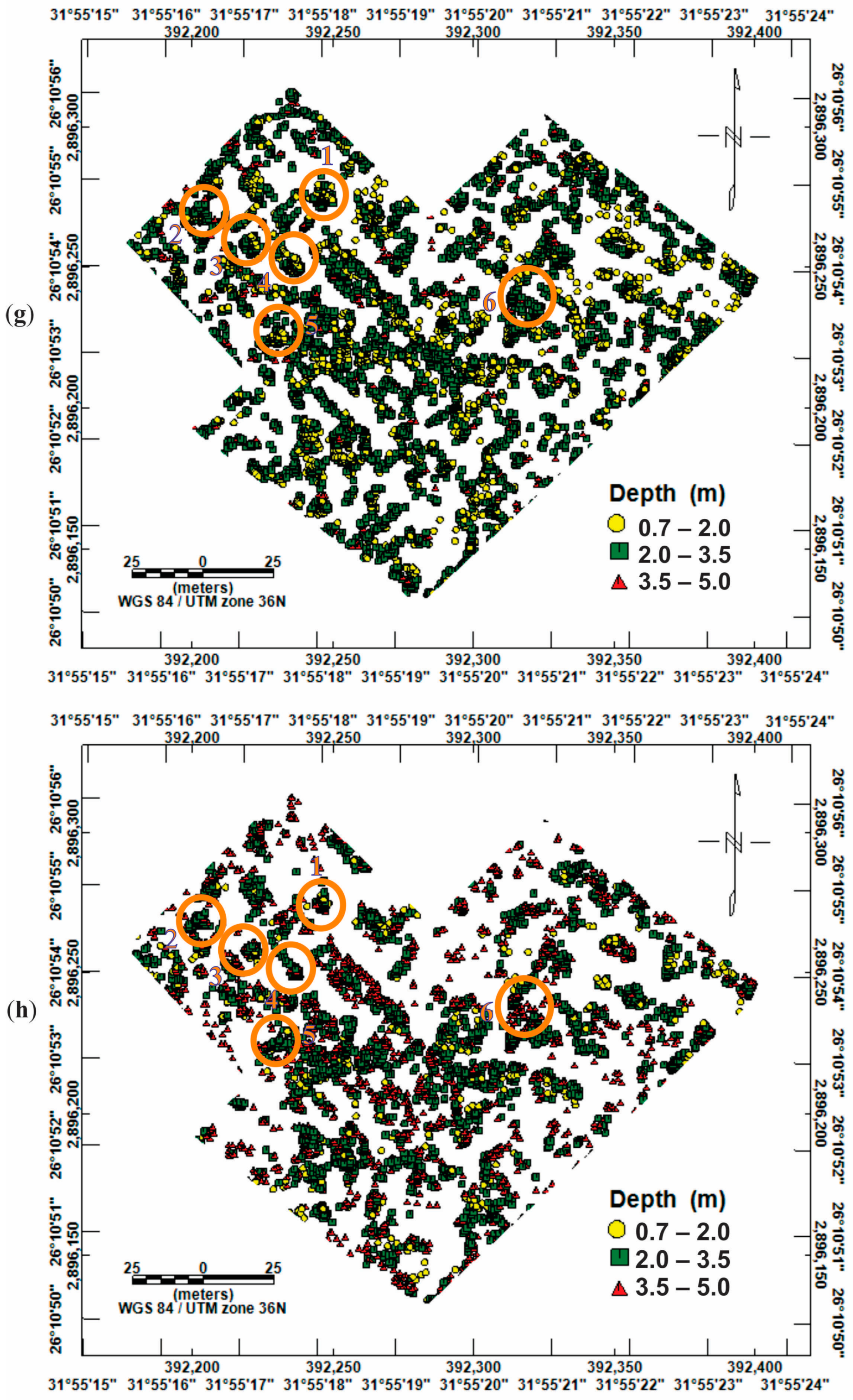
The Euler method was used to create a total magnetic intensity map with the Geosoft Oasis Montaj software v. 8.4. The shape of the assumed geometric bodies that make up the Euler solutions is indicated by the structural index. Sill, dyke, or edge look best when exhibited at an index of 1.0, whereas a distant spherical or compact body could look best when displayed at an index of 3.0 [53]. The analysis of the source depth maps produced by the Euler deconvolution approach reveals that the depths of the source bodies are found between 0.7 and 5 m. These findings are in good agreement with the SPI procedure. Using structural index (SI) equal 1, the depth ranges of most magnetic sources are from 0.7 m to 4.0 m (Figure 5g), while they are from 0.7 m to 4.8 m when SI = 2 (Figure 5h).

6.2. GPR Data Interpretation

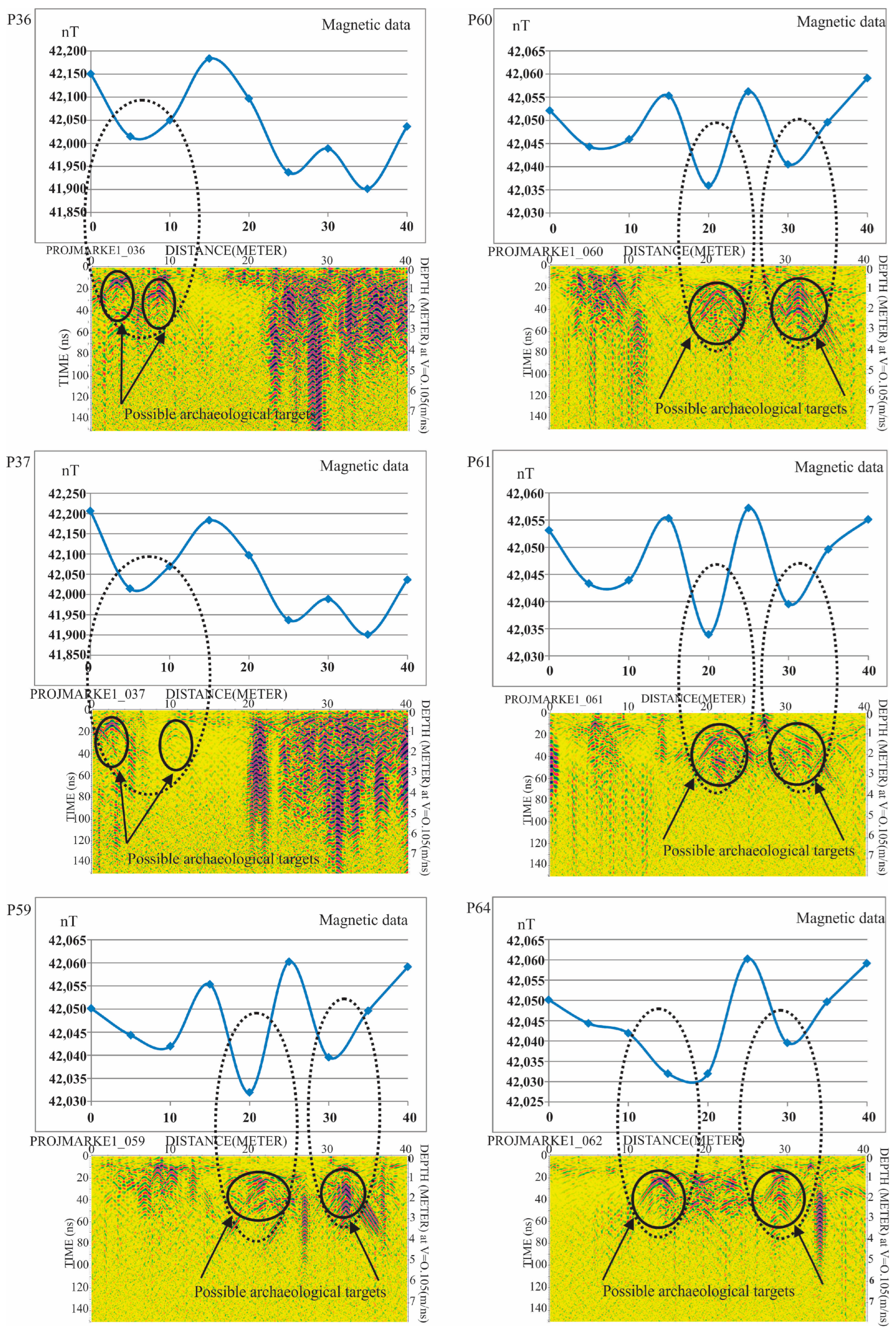
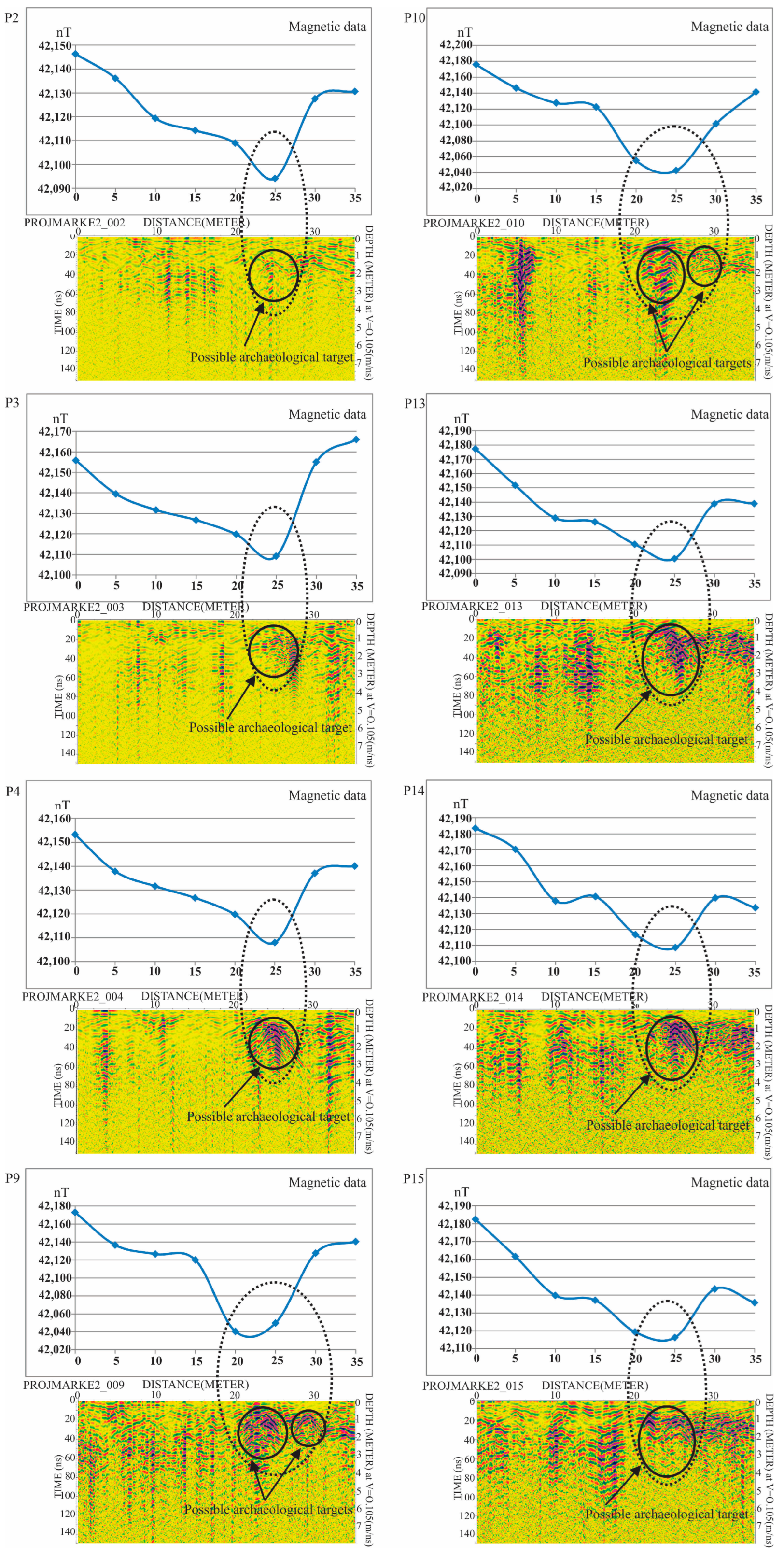
Examination of 513 radargram sections within all 12 blocks reveals that some of these profiles contain considerable hyperbolas of different amplitudes and widths reflecting different types of source bodies. On the other hand, some profiles do not have noticeable hyperbolas. Therefore, to keep the length of this article, only the profiles with distinct hyperbolas are illustrated. A summary of all hyperbolas that are predicted from all blocks with the current site that reflect potential targets is presented in Table 2. For each hyperbola that was marked by a black circle, the surface distance, maximum horizontal dimension, amplitude, two-way time (TWT), and depth to its top and bottom were estimated (Figure 6 and Figure 7).
Important potential successive profiles P36, P37, P59–P61, and P64 at block (A1) with lengths of 40 m are shown in Figure 6. All these mentioned profiles exhibit two prominent hyperbolas that are remarkable anomalies. Important potential consecutive profiles P2–P4, P9, P10, and P13–P15 in block (C3) with lengths of 35 m are shown in Figure 7. One distinct hyperbola is seen in all the profiles, with the exception of P9 and P10 which contain two hyperbolas. These hyperbolas may represent fundamental objects of archaeological nature, such as walls, tombs, or any buried artifacts. Figure 6 and Figure 7 illustrate a comparison of the magnetic anomaly and the hyperbola of the radargram for the same profile using the 2D sections of the magnetic data and the GPR.
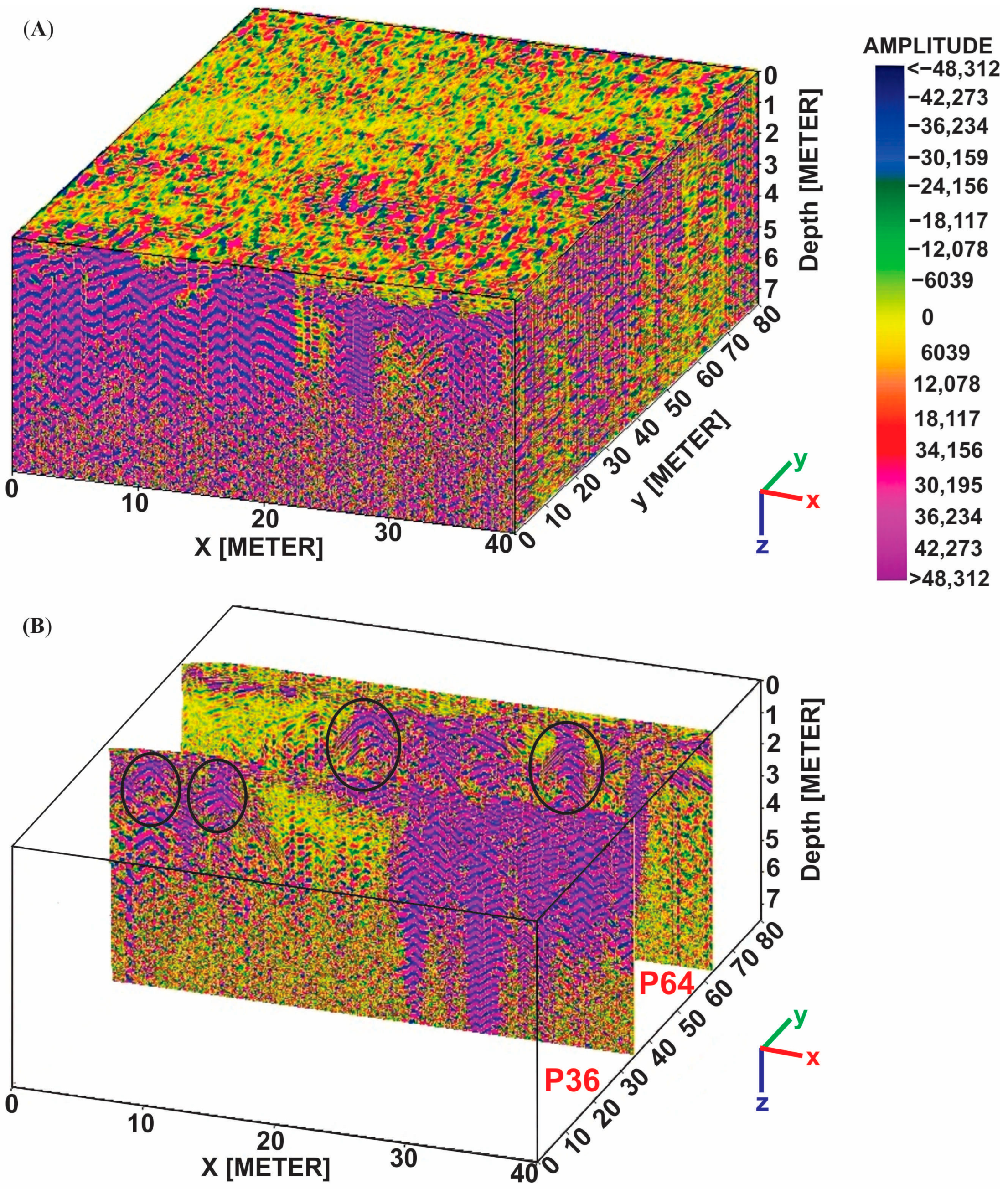
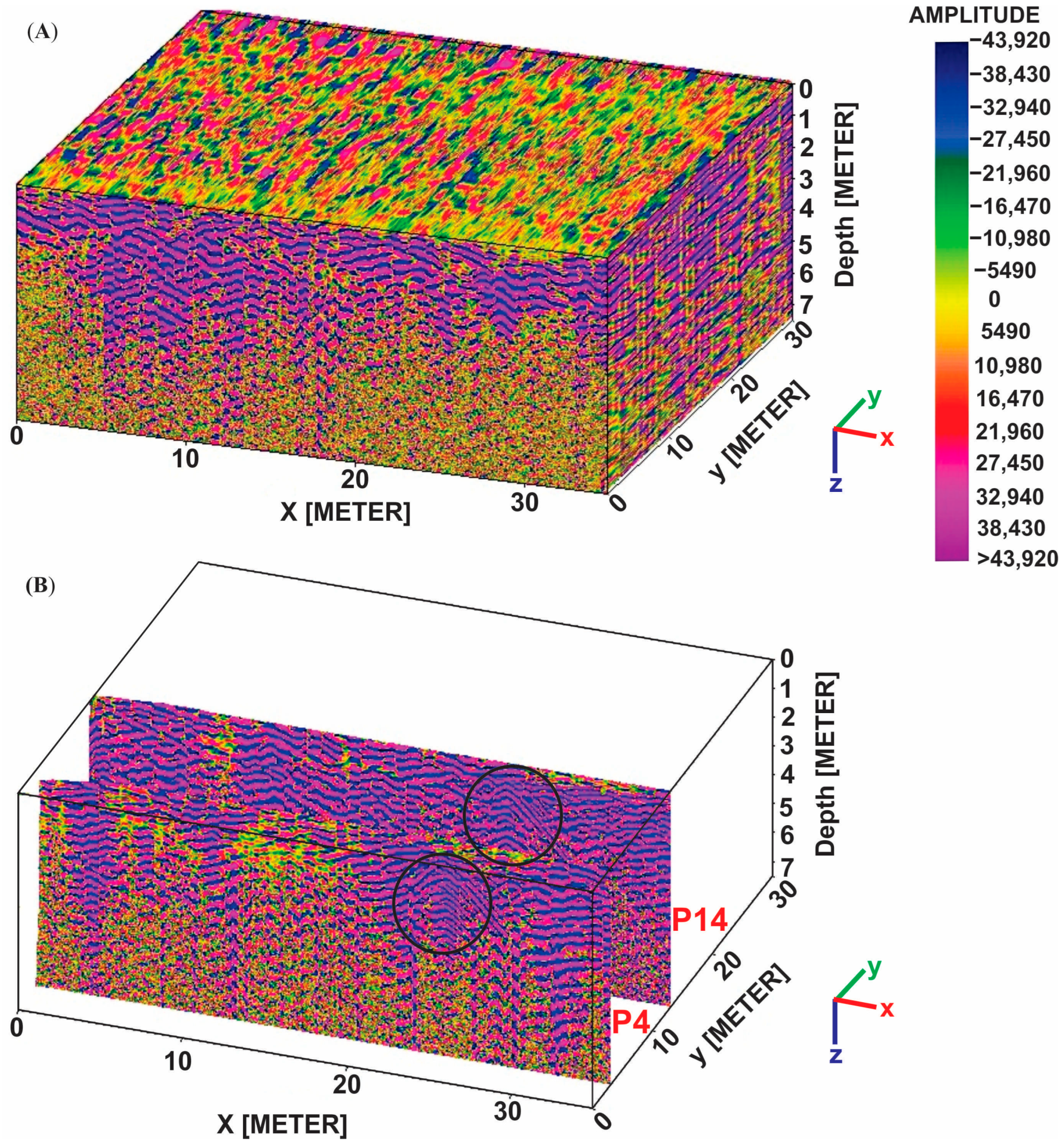
A three-dimensional visualization of the radar data in the current site was made by collecting all measured 2D radargram profiles in the small blocks (A and C) into Reflex Software v.5.8 (Figure 8 and Figure 9). To emphasize the most significant features, this model can be sliced vertically at any place. The black circles indicate the potential targets.

7. Integration of the Geophysical Data

Integration of two geophysical techniques yields reliable and confirmed results during data interpretation. The magnetic and GPR findings used in the current study confirmed each other where the positions and depths of potential anomalies in both tools were the same. Only the anomalies confirmed by the two methods were proposed to be archaeological objects with depths ranging from 0.7 m to 3 m.
Figure 10 shows the precise positions of buried targets with different dimensions, shapes, and depths based on magnetic and GPR results. To confirm these findings, excavation must be implemented, which could not be done by the current authors due to security reasons. Therefore, one of the most important recommendations to the Egyptian Antiquities Authority is to excavate in the places of the inferred targets. A close examination of Figure 10 reveals that most of the anomalies are small (approximately 5 m × 4 m), indicating the presence of tombs, while anomaly No. 6 is the largest, measuring 17 m × 11 m and indicating the location of the buried Coptic Monastery of Apa Moses. Many authors have investigated different sites in Egypt using the GPR technique, and their results are compatible with our findings [54,55].

8. Summary and Conclusions

The Abydos site is one of the most well-known ancient Egyptian sites for popular tourist destinations due to the abundance of many discovered and undiscovered monuments. Therefore, the main objective of this work is to explore the Coptic Monastery of Apa Moses in Abydos marketplace which is found in the ancient heritage books in Abydos site, Sohag, Egypt, and any other artifacts such as ancient walls and tombs. Magnetic and GPR surveys were implemented to achieve this goal. Advanced software packages were used for analyzing and interpreting the data. Analyzing the magnetic maps showed that the site is distinguished by number of anomalies scattered in various locations with different depths, sizes, and shapes, including squares and rectangles. According to the source parameter imaging technique, the detected magnetic anomalies have an average depth of between 0.7 and 4.8 m. However, using 3D Euler deconvolution with structure indices of 1 and 2, the depths ranges are 0.7 to 4.0 m and 0.7 to 4.8 m, respectively. Some of the anomalies correspond to potential archaeological objects and others to non-archaeological aspects. The magnetic results are well confirmed by the excavations data that were conducted in some sites of the Abydos region. GPR findings showed several hyperbolas in different locations of the Abydos site that may be interpreted as archaeological features by comparing them to those inferred from magnetic results. These sites were identified as buried shallow tombs due to their depth, which ranges from 0.6 to 3 m.
Integration of magnetic and GPR techniques reveals that there are six shallow prospective targets in the current site which were attributed to archaeological features; their depths are between 0.7 and 3 m. Anomaly No. 6 is the most likely the location of the buried Coptic Monastery of Apa Moses due to its large size rather than the other targets of small sizes. This study recommends excavating areas that have previously contained archaeological features that may be extended and are very likely to be strategic targets that will increase the number of artifacts found at this site, thus increasing tourism opportunities, and thereby increasing Egypt’s national income.

Author Contributions

Methodology, A.M.A., G.Z.A.A., H.S.R., N.A.-A., S.B., K.K.M., H.A.G. and M.A.M.; Software, A.M.A., G.Z.A.A., H.S.R., N.A.-A., S.B., K.K.M., H.A.G. and M.A.M.; Validation, S.B.; Investigation, G.Z.A.A., K.K.M., H.A.G. and M.A.M.; Resources, M.A.M.; Writing—original draft, H.S.R., N.A.-A., S.B., K.K.M. and H.A.G.; Writing—review & editing, A.M.A., G.Z.A.A. and M.A.M.; Funding acquisition, N.A.-A. All authors have read and agreed to the published version of the manuscript.

Funding

This research was funded by Researchers Supporting Project number (RSPD2023R804), King Saud University, Riyadh, Saudi Arabia.

Data Availability Statement

The data is available upon request from the authors.

Acknowledgments

This research was supported by Researchers Supporting Project number (RSPD2023R804), King Saud University, Riyadh, Saudi Arabia.

Conflicts of Interest

The authors declare no conflict of interest.

References

  1. UNESCO. World Heritage Centre.mht. In Abydos, City of Pilgrimage of the Pharaohs; WHC-03/27.COM/24; UNESCO: Paris, France, 2003. [Google Scholar]
  2. Damarany, A.; Abdallah, H. The South Abydos Marketplace excavations (2009–2010, 2013): The monastery of Apa Moses. In Abydos in the First Millennium AD; O’Connell, E.R., Ed.; Peeters: Leuven, Belgium, 2020. [Google Scholar]
  3. O’Connell, E.R. Abydos in the First Millennium AD; Peeters: Leuven, Belgium, 2020. [Google Scholar]
  4. Damarany, A.; Cahail, K.M. The sarcophagus of the High Priest of Amun, Menkheperre, from the Coptic monastery of Apa Moses at Abydos. Mitt. Des Dtsch. Archäologischen Inst. Abt. Kairo 2016, 72, 11–20. [Google Scholar]
  5. Hossein, Y. A new Archaic period cemetery at Abydos. In Proceedings of the Egypt at Its Origins 3: Proceedings of the Third International Conference, ‘Origin of the State. Predynastic and Early Dynastic Egypt’, London, UK, 27 July–1 August 2008; Friedman, R.F., Fiske, P.N., Eds.; Orientalia Lovaniensia Analecta 205. Peeters: Leuven, Belgium, 2011; pp. 269–280. [Google Scholar]
  6. Gabr, A. The new archaic period cemetery at Abydos: Osteological report. In Proceedings of the Egypt at Its Origins 3: Proceedings of the Third International Conference, ‘Origin of the State. Predynastic and Early Dynastic Egypt’, London, UK, 27 July–1 August 2008; Friedman, R.F., Fiske, P.N., Eds.; Orientalia Lovaniensia Analecta 205. Peeters: Leuven, Belgium, 2011; pp. 281–293. [Google Scholar]
  7. Abudeif, A.M.; Abdel Aal, G.Z.; Masoud, M.M.; Mohammed, M.A. Geoarchaeological Investigation of Abydos Area Using Land Magnetic and GPR Techniques, El-Balyana, Sohag, Egypt. Appl. Sci. 2022, 12, 9640. [Google Scholar] [CrossRef]
  8. Abdelaal, G.Z.; Abbas, S.K.; Abudeif, A.; Mohammed, M. Utilizing Magnetic Gradiometer to Determine the Depth and Geometry of Subsurface Archaeological Features at Abydos Archaeological Site, Sohag, Egypt. Assiut Univ. J. Multidiscip. Sci. Res. 2022, 51, 279–308. [Google Scholar] [CrossRef]
  9. Conyers, L.B. Ground-penetrating radar techniques to discover and map historic graves. Hist. Archaeol. 2006, 40, 64–73. [Google Scholar] [CrossRef]
  10. Gaber, H.; AbdelAal, G.; Abudeif, A.; Mohammed, M. Magnetic survey of Abydos archaeological site, Sohag Governorate, Egypt. In Proceedings of the Eleventh International Conference on the Geology of Africa (ICGA—2022), Assiut, Egypt, 8–9 November 2022. [Google Scholar]
  11. Mohammed, M.; Abudeif, A.; AbdelAal, G.; Gaber, H. Archaeogeophysical study on the Abydos Temple site using Ground Penetrating Radar Technique, Sohag Governorate, Egypt. In Proceedings of the Fifth International Conference on New Horizons in Basic and Applied Sciences, Hurghada, Egypt, 26–29 September 2021. [Google Scholar]
  12. Ristić, A.; Govedarica, M.; Pajewski, L.; Vrtunski, M.; Bugarinović, Ž. Using ground penetrating radar to reveal hidden archaeology: The case study of the Württemberg-Stambol Gate in Belgrade (Serbia). Sensors 2020, 20, 607. [Google Scholar] [CrossRef] [PubMed] [Green Version]
  13. Mohamed, A.-M.S.; Atya, M.; AbouAly, N.; Farragawy, K.E.; Hegazy, E.E.; Saleh, M.; Kabeel, K.; El-Mahdi, A.A. Mapping the archaeological relics of catacombs at Northeast Saqqara using GPR data, Egypt. NRIAG J. Astron. Geophys. 2020, 9, 362–374. [Google Scholar] [CrossRef] [Green Version]
  14. Ibrahim, H.A.; Ebraheem, M.O. Ground-penetrating radar reflections and their archaeological significances at two ancient necropolis tombs in Kharga Oasis, Egypt. Near Surf. Geophys. 2020, 18, 713–728. [Google Scholar] [CrossRef]
  15. Ahmed, S.B.; El Qassas, R.A.; El Salam, H.F.A. Mapping the possible buried archaeological targets using magnetic and ground penetrating radar data, Fayoum, Egypt. Egypt. J. Remote Sens. Space Sci. 2020, 23, 321–332. [Google Scholar] [CrossRef]
  16. Yilmaz, S.; Balkaya, Ç.; Cakmak, O.; Oksum, E. GPR and ERT explorations at the archaeological site of Kılıç village (Isparta, SW Turkey). J. Appl. Geophys. 2019, 170, 103859. [Google Scholar] [CrossRef]
  17. Gaber, A.; El-Qady, G.; Khozym, A.; Abdallatif, T.; Kamal, S.A. Indirect preservation of Egyptian historical sites using 3D GPR survey. Egypt. J. Remote Sens. Space Sci. 2018, 21, S75–S84. [Google Scholar] [CrossRef]
  18. El-Haddad, B. Evolution of the Geological History of the Egyptian Nile at Sohag Area Using Sedimentological Studies and Remote Sensing Techniques. Master’s thesis, Geology Department, Faculty of Science, Sohag University, Sohag, Egypt, 2014. [Google Scholar]
  19. Mekkawi, M.; Arafa-Hamed, T.; Abdellatif, T. Detailed magnetic survey at Dahshour archeological sites Southwest Cairo, Egypt. NRIAG J. Astron. Geophys. 2013, 2, 175–183. [Google Scholar] [CrossRef] [Green Version]
  20. Leucci, G.; Miccoli, I.; Barbolla, D.F.; De Giorgi, L.; Ferrari, I.; Giuri, F.; Scardozzi, G. Integrated GPR and ERT Surveys for the Investigation of the External Sectors of the Castle of Melfi (Potenza, Italy). Remote Sens. 2023, 15, 1019. [Google Scholar] [CrossRef]
  21. Gaber, A.; Gemail, K.S.; Kamel, A.; Atia, H.M.; Ibrahim, A. Integration of 2D/3D ground penetrating radar and electrical resistivity tomography surveys as enhanced imaging of archaeological ruins: A case study in San El-Hager (Tanis) site, northeastern Nile Delta, Egypt. Archaeol. Prospect. 2021, 28, 251–267. [Google Scholar] [CrossRef]
  22. Mohamed, A.; El-Hussain, I.; Deif, A.; Araffa, S.; Mansour, K.; Al-Rawas, G. Integrated ground penetrating radar, electrical resistivity tomography and multichannel analysis of surface waves for detecting near-surface caverns at Duqm area, Sultanate of Oman. Near Surf. Geophys. 2019, 17, 379–401. [Google Scholar]
  23. Leandro, C.G.; Barboza, E.G.; Caron, F.; de Jesus, F.A. GPR trace analysis for coastal depositional environments of southern Brazil. J. Appl. Geophys. 2019, 162, 1–12. [Google Scholar] [CrossRef]
  24. Ebraheem, M.; Ibrahim, H. Detection of karst features using ground-penetrating radar: A case study from the western limestone plateau, Assiut, Egypt. Environ. Earth Sci. 2019, 78, 563. [Google Scholar] [CrossRef]
  25. Elkarmoty, M.; Colla, C.; Gabrielli, E.; Papeschi, P.; Bonduà, S.; Bruno, R. In-situ GPR test for three-dimensional mapping of the dielectric constant in a rock mass. J. Appl. Geophys. 2017, 146, 1–15. [Google Scholar] [CrossRef]
  26. Conyers, L.B. Ground-Penetrating Radar for Geoarchaeology; John Wiley & Sons: Hoboken, NJ, USA, 2016. [Google Scholar]
  27. Orlando, L.; Michetti, L.M.; Belelli Marchesini, B.; Papeschi, P.; Giannino, F. Dense georadar survey for a large-scale reconstruction of the archaeological site of Pyrgi (Santa Severa, Rome). Archaeol. Prospect. 2019, 26, 369–377. [Google Scholar] [CrossRef]
  28. Conyers, L.B. Interpreting Ground-Penetrating Radar for Archaeology; Routledge: London, UK, 2016. [Google Scholar]
  29. Booth, A.D.; Szpakowska, K.; Pischikova, E.; Griffin, K. Structure of an ancient Egyptian tomb inferred from ground-penetrating radar imaging of deflected overburden horizons. Archaeol. Prospect. 2015, 22, 33–44. [Google Scholar] [CrossRef] [Green Version]
  30. Conyers, L.B.; Sutton, M.-J.; St. Pierre, E. Dissecting and interpreting a three-dimensional ground-penetrating radar dataset: An example from Northern Australia. Sensors 2019, 19, 1239. [Google Scholar] [CrossRef] [Green Version]
  31. Bianco, C.; De Giorgi, L.; Giannotta, M.T.; Leucci, G.; Meo, F.; Persico, R. The Messapic Site of Muro Leccese: New Results from Integrated Geophysical and Archaeological Surveys. Remote Sens. 2019, 11, 1478. [Google Scholar] [CrossRef] [Green Version]
  32. Fontul, S.; Solla, M.; Cruz, H.; Machado, J.; Pajewski, L. Ground penetrating radar investigations in the noble Hall of São Carlos theater in Lisbon, Portugal. Surv. Geophys. 2018, 39, 1125–1147. [Google Scholar] [CrossRef]
  33. Hong, W.-T.; Kang, S.; Lee, S.J.; Lee, J.-S. Analyses of GPR signals for characterization of ground conditions in urban areas. J. Appl. Geophys. 2018, 152, 65–76. [Google Scholar] [CrossRef]
  34. Moussa, M. The Coptic Literary Dossier of Abba Moses of Abydos. Copt. Church Rev. 2003, 24, 66–90. [Google Scholar]
  35. Wipszycka, E. Moines et Communautés Monastiques en Égypte:(IVe-VIIIe Siècles); Warsaw University, Faculty of Law and Administration, Chair of Roman and Antique Law: Warsaw, Poland, 2009. [Google Scholar]
  36. Coquin, R.; Martin, M. Abydos: Archaeological and literary evidence. In The Coptic Encyclopedia; Atiya, A.S., Ed.; MacMillan: New York, NY, USA, 1991; Volume 1, pp. 38–41. [Google Scholar]
  37. Gabra, G.; Takla, H.N. Christianity and Monasticism in Upper Egypt; American University in Cairo Press: Cairo, Egypt, 2010; Volume 2. [Google Scholar]
  38. Omer, A. Geological, mineralogical and geochemical studies on the Neogene and Quaternary Nile basin deposits, Qena-Assiut stretch, Egypt. Ph.D. Thesis, South Valley University, Sohag, Egypt, 1996. [Google Scholar]
  39. Ahmed, S. Geology of the area east and southeast of Sohag. Master’s Thesis, Geology Department, Faculty of Science, Assiut University, Assiut, Egypt, 1980. [Google Scholar]
  40. Mahran, T.; El Haddad, A. Facies and depositional environments of Upper Pliocene-Pleistocne Nile sediments around Soihag area, Nile Valley. J. Saharian Stud. 1992, 1, 11–40. [Google Scholar]
  41. Mostafa, H. Geological Studies on the Area Northeast of Sohag; Geology Department, Faculty of Science, Assiut University: Assiut, Egypt, 1979; p. 152. [Google Scholar]
  42. Youssef, M.I. Structural pattern of Egypt and its interpretation. AAPG Bull. 1968, 52, 601–614. [Google Scholar]
  43. Abdallatif, T. Magnetic Prospection for Some Archaeological Sites in Egypt. Ph.D. Dissertation, Ain Shams University, Cairo, Egypt, 1998. [Google Scholar]
  44. Reynolds, J.M. An Introduction to Applied and Environmental Geophysics; John Wiley & Sons: Hoboken, NJ, USA, 2011. [Google Scholar]
  45. Ghazala, H.; El-Mahmoudi, A.; Abdallatif, T. Archaeogeophysical study on the site of Tell Toukh El-Qaramous, Sharkia Governorate, East Nile Delta, Egypt. Archaeol. Prospect. 2003, 10, 43–55. [Google Scholar] [CrossRef]
  46. Gaffney, C.F.; Gater, J.; Ovenden, S. The Use of Geophysical Techniques in Archaeological Evaluations; Institute of Field Archaeologists: Reading, UK, 2002; Volume 6. [Google Scholar]
  47. Geometrics. Portable Proton-Precession Magnetometer (G-857), Operation Manual; Geometrics: San Jose, CA, USA, 2014; p. 68. [Google Scholar]
  48. Montaj, G.O. Data Processing and Analysis Systems for Earth Science Applications (Ver. 8.3.3); Geosoft Inc.: Toronto, ON, Canada, 2015. [Google Scholar]
  49. Benedetto, A.; Pajewski, L. Civil Engineering Applications of Ground Penetrating Radar. In Springer Transactions in Civil and Environmental Engineering; Springer: Berlin/Heidelberg, Germany, 2015; Volume 385. [Google Scholar]
  50. Lazzari, M.; De Giorgi, L.; Ceraudo, G.; Persico, R. Geoprospecting survey in the archaeological site of Aquinum (Lazio, central Italy). Surv. Geophys. 2018, 39, 1167–1180. [Google Scholar] [CrossRef]
  51. Sandmeier, K.J. REFLEX W—The 2D Processing and 2D/3D Interpretation Software of Reflection, Refraction and Transmission Data with a Wide Range of Applications; Sandmeier Scientific Software for Geophysical Investigations: Karlsruhe, Germany, 2009. [Google Scholar]
  52. Abbas, A.M.; Abdallatif, T.F.; Shaaban, F.A.; Salem, A.; Suh, M. Archaeological investigation of the eastern extensions of the Karnak Temple using ground-penetrating radar and magnetic tools. Geoarchaeol. Int. J. 2005, 20, 537–554. [Google Scholar] [CrossRef]
  53. Reid, A.; Allsop, J.; Granser, H.; Millett, A.; Somerton, I.W. Magnetic interpretation in three dimensions using Euler deconvolution. Geophysics 1990, 55, 80–91. [Google Scholar] [CrossRef] [Green Version]
  54. Abbas, A.M.; Ghazala, H.H.; Mesbah, H.S.; Atya, M.A.; Radwan, A.; Hamed, D.E. Implementation of ground penetrating radar and electrical resistivity tomography for inspecting the Greco-Roman Necropolis at Kilo 6 of the Golden Mummies Valley, Bahariya Oasis, Egypt. NRIAG J. Astron. Geophys. 2016, 5, 147–159. [Google Scholar] [CrossRef] [Green Version]
  55. Ismail, A.M.A. Geophysical, Hydrological, and Archaeological Investigation in the East Bank Area of Luxor-Southern Egypt; University of Missouri: Rolla, MO, USA, 2003. [Google Scholar]
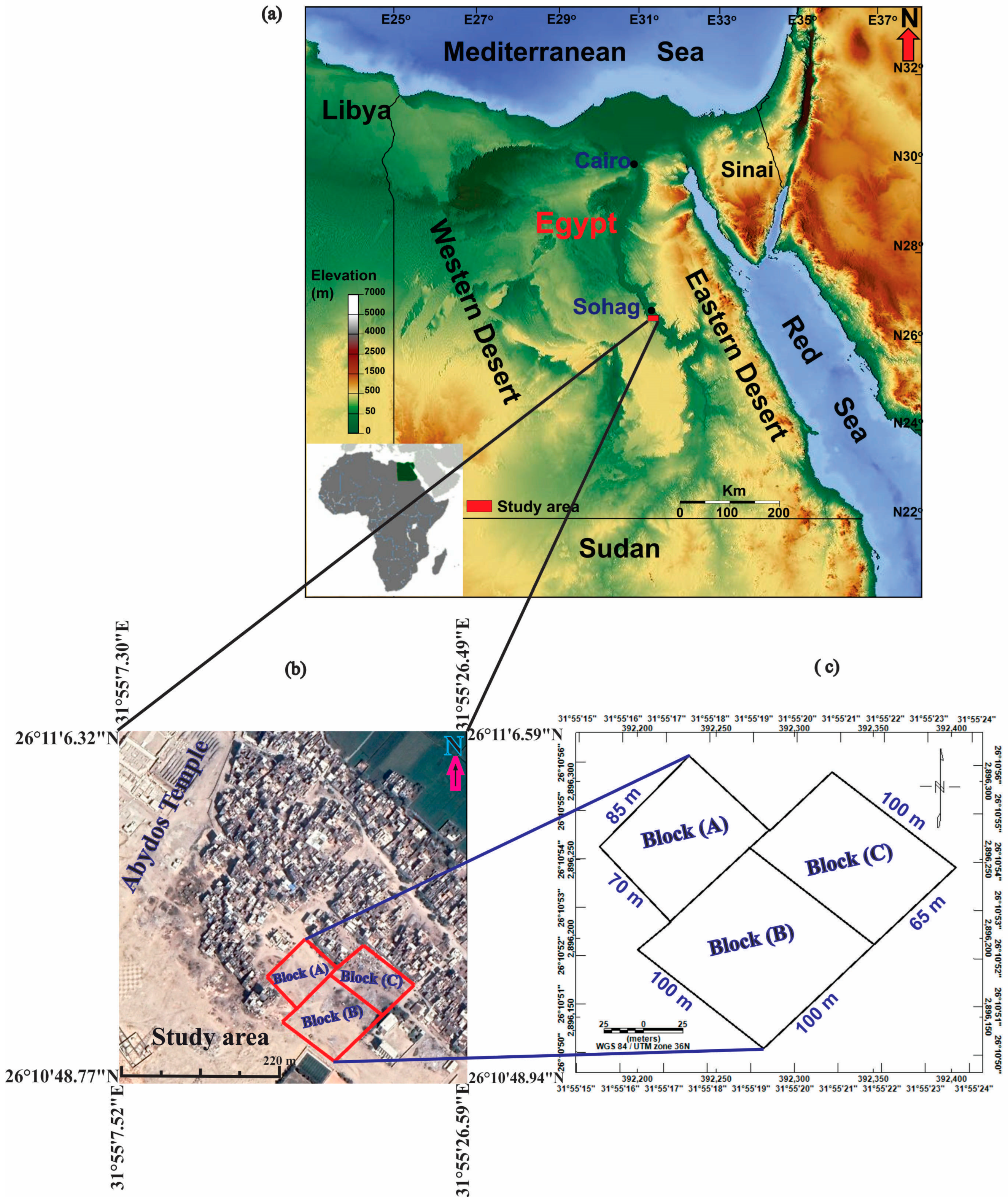
Figure 1. (a) A map of Egypt showing the location of the investigated site in Sohag Governorate; (b) a Google Earth map showing the specifics of the Al-Arraba marketplace south of Abydos site showing surveyed grids; and (c) a layout image of the measured blocks at the study area.
Sustainability 15 11119 g001
Figure 2. (a) The location of the Al-Arraba marketplace, where inhabitants leveled the land and completely covered it in sand and clays; (b) a photograph of the study site which was immediately taken after the market was established; (c) the fieldwork magnetic survey using the G-856 magnetometer; and (d) the field GPR survey using the GSSI-SIR 4000 equipment and a 200 MHZ antenna.
Sustainability 15 11119 g002
Figure 3. The major geologic units illustrated on a lithological map of the study area [38].
Sustainability 15 11119 g003
Figure 4. GPR grid design for the investigation area.
Sustainability 15 11119 g004
Figure 5. Shaded color relief maps of the: (a) total magnetic intensity; (b) high pass filter; (c) first vertical derivative filter; (d) analytical signal filter; (e) tilt derivative; (f) source parameter imaging technique; (g) Euler deconvolution solutions with structural index (SI) = 1.0; and (h) Euler deconvolution solutions with SI = 2. The black circles represent the magnetic anomalies that were confirmed by the GPR approach and may be artifacts.
Sustainability 15 11119 g005aSustainability 15 11119 g005bSustainability 15 11119 g005c
Figure 6. Examples of the correlation between the magnetic and GPR findings along some profiles such as P36, P37, P59–P61, and P64 at block (A1). The black circles display potential anomalous features, which are indicated by the hyperbolic shape that may reflect ancient artifacts.
Sustainability 15 11119 g006
Figure 7. Examples of the correlation between the magnetic and GPR findings along some profiles such as P2–P4, P9, P10, and P13-15 at block (C3). The black circles display potential anomalous features, which are indicated by the hyperbolic shape that may reflect ancient artifacts.
Sustainability 15 11119 g007
Figure 8. (A) A 3D illustration of radargram model of the block A1, and (B) the vertical slices of the radargram sections 36 and 64 as examples. The black circle displays the hyperbolas that suggest potential targets.
Sustainability 15 11119 g008
Figure 9. (A) A 3D illustration of radargram model of the block C3, and (B) the vertical slices of the radargram sections 4 and 14 as examples. The black circle displays the hyperbolas which suggest potential targets.
Sustainability 15 11119 g009
Figure 10. Magnetic and GPR findings suggest a possible location for artifacts. These are the locations of buried targets of various sizes.
Sustainability 15 11119 g010
Table 1. Major geological formations in Sohag governorate include the study site.
FormationAgeDescriptionReferences
Wadi depositsNeogene and Quaternary
Recent (Holocene)
A disintegrated product of the neighboring Eocene carbonate, in addition to the sediments’ previously processed material[43]
Alluvial deposits
(Nile floodplain)
PleistoceneClays and silts with intercalations of sandstone[43]
DandaraFluvial fine sand-silt intercalations and accumulations in low-energy environments[44]
GhawanimSandstone from the Nile showing the heavy mineral’s earliest occurrence[38]
KomOmboSediments made up of sand and gravel with a lot of large igneous and metamorphic fragments in them.[45]
QenaSands and gravels that are quartzose and devoid of igneous and metamorphic pieces[43]
IssawiaLate Pliocene/Early
Pleistocene
Clastic facies along lake borders and carbonate facies in the middle zones[43]
MuneihaEarly PlioceneFluviatile sediments have a predominance of sand, silt, and mud intercalations, as well as bedded grey and brown clays intercalated with thin beds and lenses of silt and fine sand[44]
DrunkaLower EoceneA succession of medium- to thick-bedded limestone that contains siliceous concretions of various sizes and is heavily bioturbated in some horizons[46]
ThebesMassive to layered limestone that contains flint nodules, as well as marls that are abundant in nummulites and planktonic foraminifera[46]
Table 2. Summarize the parameters of the detected anomalies features at the study area.
GridProfile No.Recognized Archaeological AnomalySurface Distance (m)Maximum Horizontal Dimension (m)Two-Way Time (ns)Depth to Its Top and Bottom (m)Amplitude (m)
(A1)P3611 to 54100.7 to 1.71
27 to 114120.8 to 21.2
P3710.4 to 4.44110.6 to 1.61
28.3 to 12.33140.8 to 1.81
P59118.2 to 24.26140.8 to 32.2
229.8 to 34.85120.6 to 2.82.2
P60117.8 to 22.95.1150.8 to 3.12.3
229 to 34.95.9120.6 to 2.82.2
P61118.2 to 24.36.1150.8 to 2.71.9
228.1 to 345.9140.7 to 2.72
P64111 to 16.35.3180.9 to 2.81.9
226.8 to 31.95.1170.8 to 2.92.1
(C3)P2123 to 274180.9 to 2.71.8
P3123 to 274140.8 to 2.71.9
P4122 to 286130.7 to 2.61.9
P9121 to 25.84.8100.6 to 2.62
227.3 to 31.34.3120.8 to 2.51.7
P10120.5 to 25.14.6130.7 to 2.72
227 to 31.54.5150.8 to 2.41.6
P13122 to 275100.6 to 2.31.7
P14123 to 285120.8 to 2.71.9
P15121.8 to 26.64.8170.9 to 2.51.6
Disclaimer/Publisher’s Note: The statements, opinions and data contained in all publications are solely those of the individual author(s) and contributor(s) and not of MDPI and/or the editor(s). MDPI and/or the editor(s) disclaim responsibility for any injury to people or property resulting from any ideas, methods, instructions or products referred to in the content.