


Traditional Water Systems Informing Sustainable Contemporary Drylands Design: Documentation, Extraction, and Deployment


Abstract
1. Introduction
1.1. Bedrock of This Study
1.2. Localized Traditional Infrastructure and Sustainable Built Environment
2. Materials and Methods
2.1. Survey: What Materials Are Available?
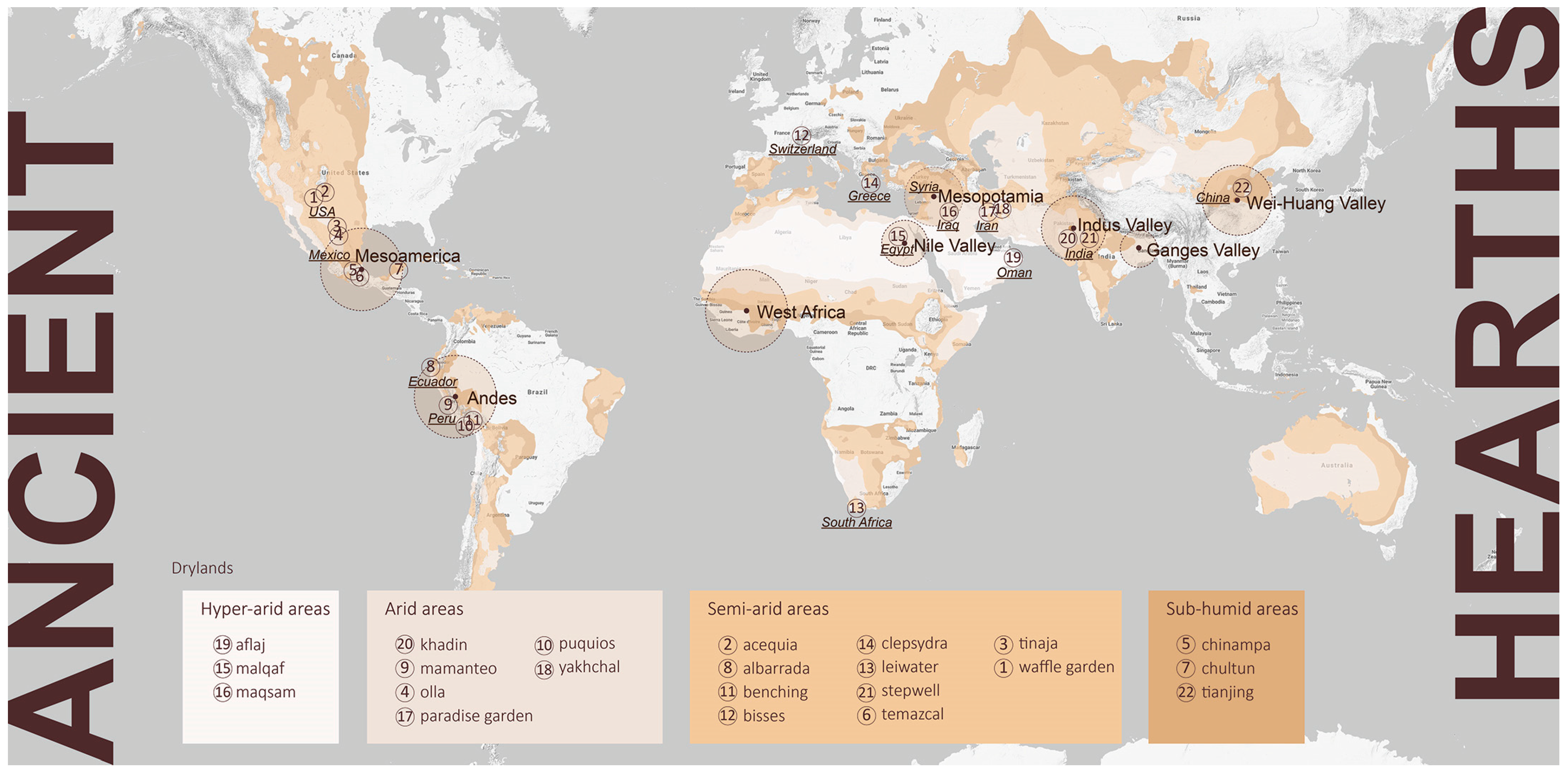
2.2. Digging In: Scope, Sites, and Methods
2.3. Documentation
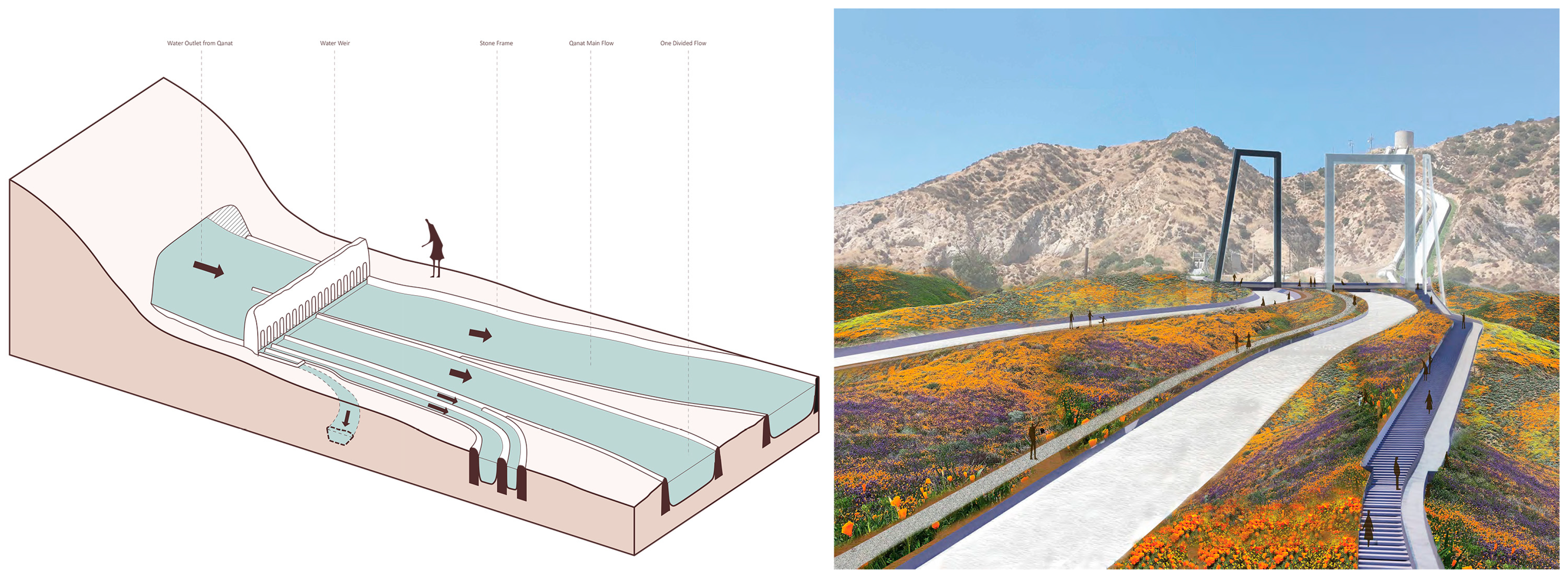
2.4. Extraction
3. Results
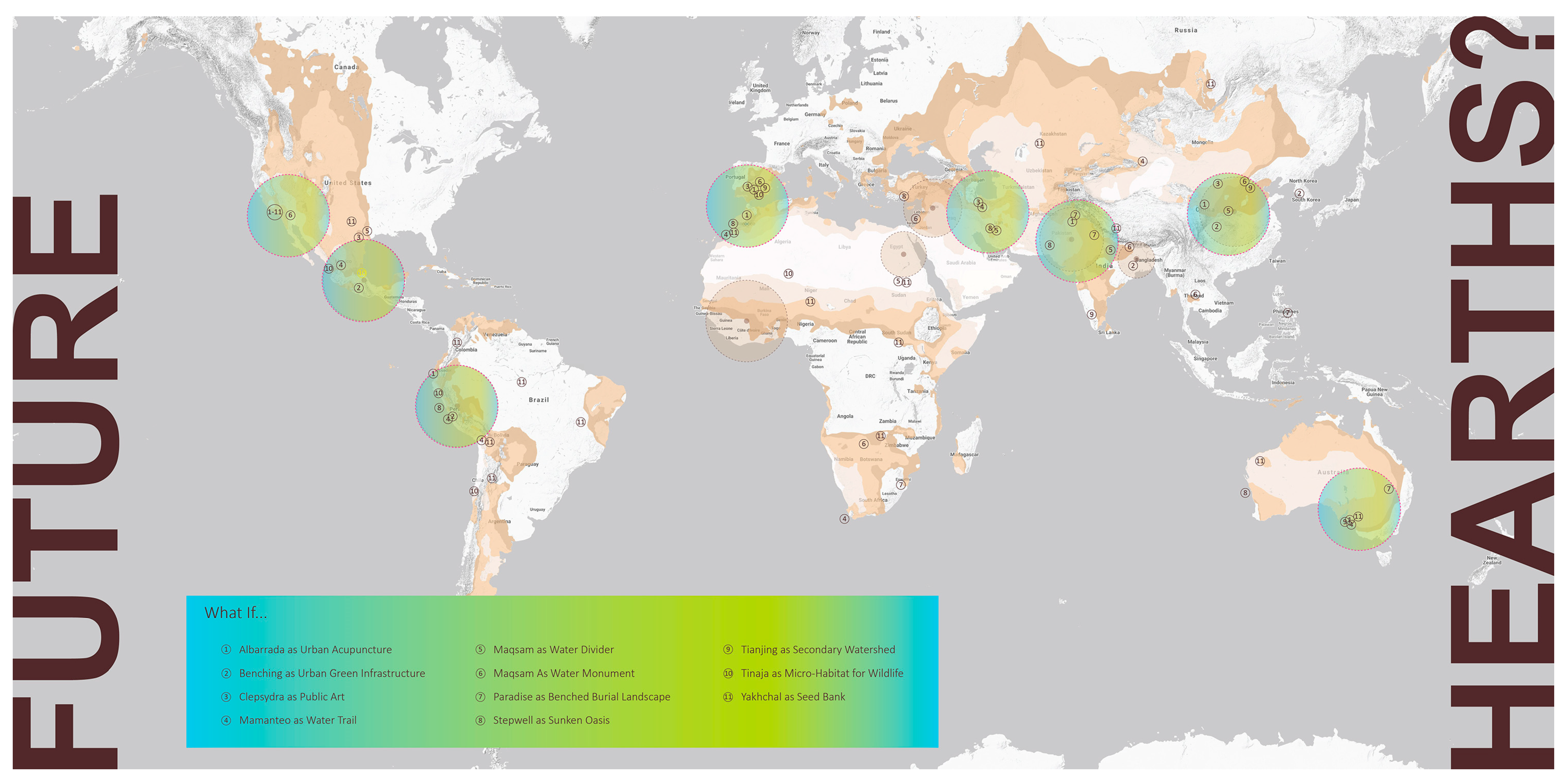
3.1. Deployment
3.2. Expansions
4. Discussion
4.1. Taxonomies of Form, Function, and Social Governance
4.2. Research-by-Design for Various Scenarios
4.3. Limitations and Next Steps
5. Conclusions
Author Contributions
Funding
Institutional Review Board Statement
Informed Consent Statement
Data Availability Statement
Acknowledgments
Conflicts of Interest
References
- Potts, D.T. Mesopotamian Civilization: The Material Foundations; A&C Black: London, UK, 1997. [Google Scholar]
- Mojtahed-Zadeh, P. The Persian Gulf in the Geographical Views of the Ancient World. In Cartographie Historique du Golfe Persique: Actes du Colloque Organisé Les 21 et 22 Avril 2004 à Téhéran par l’EPHE, L’université de Téhéran et le Centre de Documentation et de Recherche d’Iran; Peeters Pub & Booksellers: Louvain, Belgium, 2006; p. 11. [Google Scholar]
- McIntosh, J. The Ancient Indus Valley: New Perspectives; Abc-Clio: Santa Barbara, CA, USA, 2008. [Google Scholar]
- Connah, G. African Civilizations: An Archaeological Perspective; Cambridge University Press: Cambridge, UK, 2015. [Google Scholar]
- Bourget, S.; Jones, K.L. (Eds.) The Art and Archaeology of the Moche: An Ancient Andean Society of the Peruvian North Coast; University of Texas Press: Austin, TX, USA, 2009. [Google Scholar]
- Bishop, C.W. The Geographical Factor in the Development of Chinese Civilization; American Geographical Society: New York, NY, USA, 1922. [Google Scholar]
- Ahmadi, H.; Samani, A.N.; Malekian, A. The qanat: A living history in Iran. In Water and Sustainability in Arid Regions: Bridging the Gap between Physical and Social Sciences; Springer: Dordrecht, The Netherlands, 2010; pp. 125–138. [Google Scholar] [CrossRef]
- UNESCO World Heritage. “The Persian Qanat.” UNESCO World Heritage Centre. Available online: https://whc.unesco.org/en/list/1506/ (accessed on 5 January 2020).
- Fagan, B. The Great Warming: Climate Change and the Rise and Fall of Civilizations; Bloomsbury Publishing USA: New York, NY, USA, 2008. [Google Scholar]
- Pachauri, R.K.; Allen, M.R.; Barros, V.R.; Broome, J.; Cramer, W.; Christ, R.; Church, J.A.; Clarke, L.; Dahe, Q.; Dasgupta, P.; et al. Climate Change 2014: Synthesis Report. Contribution of Working Groups I, II and III to the Fifth Assessment Report of the Intergovernmental Panel on Climate Change; IPCC: Geneva, Switzerland, 2014. [Google Scholar]
- Pörtner, H.-O.; Roberts, D.C.; Poloczanska, E.S.; Mintenbeck, K.; Tignor, M.; Alegría, A.; Craig, M.; Adams, H.; Adelekan, I.; Adler, C.; et al. IPCC, 2022: Summary for Policymakers. Available online: https://www.ipcc.ch/report/ar6/wg2/downloads/report/IPCC_AR6_WGII_SummaryForPolicymakers.pdf (accessed on 2 February 2023).
- Anwar, M.R.; Liu, D.L.; Macadam, I.; Kelly, G. Adapting agriculture to climate change: A review. Theor. Appl. Climatol. 2013, 113, 225–245. [Google Scholar] [CrossRef]
- Arnell, N.W.; Gosling, S.N. The impacts of climate change on river flood risk at the global scale. Clim. Chang. 2016, 134, 387–401. [Google Scholar] [CrossRef]
- Xu, R.; Yu, P.; Abramson, M.J.; Johnston, F.H.; Samet, J.M.; Bell, M.L.; Haines, A.; Ebi, K.L.; Li, S.; Guo, Y. Wildfires, global climate change, and human health. N. Engl. J. Med. 2020, 383, 2173–2181. [Google Scholar] [CrossRef] [PubMed]
- Martinez, G.S.; Imai, C.; Masumo, K. Local heat stroke prevention plans in Japan: Characteristics and elements for public health adaptation to climate change. Int. J. Environ. Res. Public Health 2011, 8, 4563–4581. [Google Scholar] [CrossRef] [PubMed]
- Achakulwisut, P.; Anenberg, S.C.; Neumann, J.E.; Penn, S.L.; Weiss, N.; Crimmins, A.; Fann, N.; Martinich, J.; Roman, H.; Mickley, L.J. Effects of increasing aridity on ambient dust and public health in the US Southwest under climate change. GeoHealth 2019, 3, 127–144. [Google Scholar] [CrossRef] [PubMed]
- Jiang, Y.; Yang, Y. Environmental justice in greater Los Angeles: Impacts of spatial and ethnic factors on residents’ socioeconomic and health status. Int. J. Environ. Res. Public Health 2022, 19, 5311. [Google Scholar] [CrossRef] [PubMed]
- United Nations. State of World Population: Unleashing the Potential of Urban Growth; UN: New York, NY, USA, 2007. [Google Scholar]
- Chou, M. Australian local governments and climate emergency declarations: Reviewing local government practice. Aust. J. Public Adm. 2021, 80, 613–623. [Google Scholar] [CrossRef]
- Keenan, J.M. Promise to Progress in the Ecological Medium. In Projective Ecologies; Reed, C., Ed.; Actar D, Inc.: New York, NY, USA, 2020; pp. 6–11. [Google Scholar]
- Howard, E. Garden Cities of Tomorrow; Faber: London, UK, 1946. [Google Scholar]
- Karamouz, M. Water Systems Analysis, Design, and Planning: Urban Infrastructure; CRC Press: Boca Raton, FL, USA, 2021. [Google Scholar]
- Watson, J.; Davis, W. Lo-Tek: Design by Radical Indigenism; Taschen: Cologne, Germany, 2020. [Google Scholar]
- McHarg, I.L.; American Museum of Natural History. Design with Nature; American Museum of Natural History: New York, NY, USA, 1969. [Google Scholar]
- Rottle, N.; Yocom, K. Basics Landscape Architecture 02: Ecological Design; Bloomsbury Publishing: London, UK, 2017. [Google Scholar]
- Palazzo, E.; Wang, S. Landscape Design for Flood Adaptation from 20 Years of Constructed Ecologies in China. Sustainability 2022, 14, 4511. [Google Scholar] [CrossRef]
- Klemm, W.; Lenzholzer, S.; van den Brink, A. Developing green infrastructure design guidelines for urban climate adaptation. J. Landsc. Archit. 2017, 12, 60–71. [Google Scholar] [CrossRef]
- Steiner, F.; Simmons, M.; Gallagher, M.; Ranganathan, J.; Robertson, C. The ecological imperative for environmental design and planning. Front. Ecol. Environ. 2013, 11, 355–361. [Google Scholar] [CrossRef] [PubMed]
- Hunt, J.D. Historical Ground: The Role of History in Contemporary Landscape Architecture; Routledge: New York, NY, USA, 2014. [Google Scholar]
- Margolis, L.; Chaouni, A.; Dreiseitl, H. Out of Water: Design Solutions for Arid Regions; Birkhäuser: Basel, Switzerland, 2015. [Google Scholar]
- Solano, S. Reimaging the Arid. From the South: Global Perspectives on Landscape and Territory; International Landscape Collaborative: Belmont, MA, USA, 2019; pp. 151–162. [Google Scholar]
- Bryant, M.; Allan, P.; Yarina, L. Applying and communicating indigenous land management knowledge systems and practices to climate change adaptation. Hist. Environ. 2019, 31, 36–48. [Google Scholar]
- Al-Ghafri, A.S.; Inoue, T.; Nagasawa, T. Aflaj irrigation systems of Oman, the way of water distribution. In Proceedings of the XIV Memorial CIGR World Congress, Tsukuba, Japan, 28 November–1 December 2000; Volume 28. [Google Scholar]
- Agnew, C. World Atlas of Desertification: United Nations Environment Programme; Edward Arnold: London, UK, 1992; p. 69. [Google Scholar]
- Greve, P.; Roderick, M.L.; Ukkola, A.M.; Wada, Y. The aridity index under global warming. Environ. Res. Lett. 2019, 14, 124006. [Google Scholar] [CrossRef]
- D’Arrigo, R.; Wilson, R.; Palmer, J.; Krusic, P.; Curtis, A.; Sakulich, J.; Bijaksana, S.; Zulaikah, S.; Ngkoimani, L.O. Monsoon drought over Java, Indonesia, during the past two centuries. Geophys. Res. Lett. 2006, 33, L04709. [Google Scholar] [CrossRef]
- Conway, H.; Roenisch, R. Understanding Architecture: An Introduction to Architecture and Architectural History; Psychology Press: London, UK, 2005. [Google Scholar]
- Advanced Design Research Studio. Stub: Atlas of Dry Lands Design. Master’s Thesis, University of Southern California, Los Angeles, CA, USA, 2020. [Google Scholar]
- Zhang, C. Comparative Study on Form of “Courtyard” Between Traditional Vernacular Dwellings in the Area South Yangtze River and Ancient Roma. Master’s Thesis, Jilin Jianzhu University, Changchun, China, 2018; p. 81. [Google Scholar]
- Livingston, M.; Beach, M. Steps to Water: The Ancient Stepwells of India; Princeton Architectural Press: Princeton, NJ, USA, 2002. [Google Scholar]
- Pingree, D. Legacies in astronomy and celestial omens. In The Legacy of Mesopotamia; Clarendon Press Oxford: Oxford, UK, 1998; pp. 125–137. [Google Scholar]
- Theodossiou, E.; Kalyva, E.M. The Ancient Clepsydra of Athens. Bull. Br. Sundial Soc. 2002, 14, 162–166. [Google Scholar]
- diviningLAB. HazelDRY: Analyzing Cities to Create Urban Water Supply Solutions That Work, Worldwide; diviningLAB, LLC: Los Angeles, CA, USA, 2020. [Google Scholar]
- Padial, J.M.; Miralles, A.; De la Riva, I.; Vences, M. The integrative future of taxonomy. Front. Zool. 2010, 7, 1–14. [Google Scholar] [CrossRef] [PubMed]
- Hight, C. Designing Ecologies. In Projective Ecologies; Reed, C., Ed.; Actar D, Inc.: New York, NY, USA, 2020; pp. 88–109. [Google Scholar]
- Ghosn, R.; Jazairy, E.H. Geostories: Another Architecture for the Environment; ACTAR: New York, NY, USA, 2022. [Google Scholar]
- Nordenson, C.S.; Nordenson, G.; Chapman, J. Structures of Coastal Resilience; Island Press: Washington, DC, USA, 2018. [Google Scholar]
- Arnold, H.; Walli-Richardson, K. Digital Atlas of Dry Lands Design. 2020; unpublished work. [Google Scholar]


| Climate Region | Water Systems | Origin | Period | Typology | Function | ||||
|---|---|---|---|---|---|---|---|---|---|
| Catchment | Conveyance | Infiltration | Ritual | Storage | |||||
| Hyper-arid | Aflaj | Oman | 500 AD-Present | Line | x | x | x | x | |
| Malqaf | Egypt | 3000 BCE-Present | Building | x | x | x | |||
| Maqsam | Iran | 500 CE-Present | Device | x | |||||
| Arid | Khadin | India | 1400 CE-Present | Field | x | x | x | x | |
| Mamanteo | Peru | 600 CE-Present | Field | x | x | x | x | x | |
| Olla | Mexico | 2000 BCE-Present | Vessel | x | x | x | |||
| Paradise Garden | Iran | 529 BCE-Present | Field | x | x | x | |||
| Puquios | Peru | 400 CE-Present | Line | x | x | ||||
| Yakhchal | Iran | 300 BCE-Present | Device | x | x | ||||
| Semi-arid | Acequia | Spain/USA | 2000 BCE-Present | Line | x | x | x | x | |
| Albarrada | Ecuador | 1600 BCE-Present | Field | x | x | x | x | ||
| Benching | Peru | 3000 BCE-Present | Field | x | x | ||||
| Bisse | Switzerland * | 1200 CE-1900 CE | Line | x | x | ||||
| Clepsydra | Greece | 700 BCE-Present | Device | x | |||||
| Leiwater | South Africa | 1850 BCE-Present | Line | x | x | ||||
| Stepwell | India | 250 BCE-1800CE | Building | x | x | x | x | ||
| Temazcal | Mexico | 1500 BCE-Present | Building | x | |||||
| Tinaja | Mexico/USA | 900 CE-Present | Vessel | x | x | ||||
| Waffle Garden | USA | 3500 BCE-Present | Field | X | x | x | |||
| Sub-humid | Chinampa | Mexico | 1150 CE-Present | Field | x | x | |||
| Chultun | Mexico | 900 BCE-900CE | Vessel | x | x | x | |||
| Tianjing | China | 1400 BCE-Present | Building | x | x | x | x | ||
| Water Systems | Explanation in Plain Language |
|---|---|
| Aflaj | An aqueduct that makes groundwater available year-round. |
| Malqaf | A low-cost and efficient natural cooling system for domestic use. |
| Maqsam | A divider for water justice. |
| Khadin | A low-cost multifunctional irrigation system for food production. |
| Mamanteo | Sustainable land art that increases the natural water flow by more than 500% in dry seasons. |
| Olla | An irrigation vessel to grow better plants for both domestic and agricultural use. |
| Paradise Garden | A garden that implies the idea of perfection in this imperfect world. |
| Puquios | A series of monumental desert spirals that reliably deliver groundwater to villages. |
| Yakhchal | A natural cooler that is low-cost and efficient for communities. |
| Acequia | A fair system for eco-sharing in the neighborhood. |
| Albarrada | A landform that embraces hillsides to capture the runoff for people, animals, and food. |
| Benching | A terrain intervention to prevent landslides, grow more food, save water, and create land art. |
| Bisse | An aqueduct to lead people to food and wine. |
| Clepsydra | A device for visualizing time driven by water. |
| Leiwater | A shared water system for backyard farming in dry periods. |
| Stepwell | A monumental sunken plaza providing drinking water for all. |
| Temazcal | A small dome - the whole universe. |
| Tinaja | An unseen landscape water bowl in the wilderness. |
| Waffle Garden | A do-it-yourself modular farming method using local materials. |
| Chinampa | A self-sufficient and productive floating garden. |
| Chultun | Versatile water storage for domestic or community use. |
| Tianjing | A house courtyard that works as a water catchment. |
Disclaimer/Publisher’s Note: The statements, opinions and data contained in all publications are solely those of the individual author(s) and contributor(s) and not of MDPI and/or the editor(s). MDPI and/or the editor(s) disclaim responsibility for any injury to people or property resulting from any ideas, methods, instructions or products referred to in the content. |
© 2023 by the authors. Licensee MDPI, Basel, Switzerland. This article is an open access article distributed under the terms and conditions of the Creative Commons Attribution (CC BY) license (https://creativecommons.org/licenses/by/4.0/).
Share and Cite
Jiang, Y.; Arnold, H. Traditional Water Systems Informing Sustainable Contemporary Drylands Design: Documentation, Extraction, and Deployment. Sustainability 2023, 15, 10966. https://doi.org/10.3390/su151410966
Jiang Y, Arnold H. Traditional Water Systems Informing Sustainable Contemporary Drylands Design: Documentation, Extraction, and Deployment. Sustainability. 2023; 15(14):10966. https://doi.org/10.3390/su151410966
Chicago/Turabian StyleJiang, Yuliang, and Hadley Arnold. 2023. "Traditional Water Systems Informing Sustainable Contemporary Drylands Design: Documentation, Extraction, and Deployment" Sustainability 15, no. 14: 10966. https://doi.org/10.3390/su151410966
APA StyleJiang, Y., & Arnold, H. (2023). Traditional Water Systems Informing Sustainable Contemporary Drylands Design: Documentation, Extraction, and Deployment. Sustainability, 15(14), 10966. https://doi.org/10.3390/su151410966