Article

Potential for Applying Nature-Based Solutions to Urban Waterways: The Case Study of Medveščak and Črnomerec Streams in the City of Zagreb, Croatia

by
Monika Jutrović
1,
Dora Tomić Reljić
2,*,
Monika Zovko
3,
Marina Bubalo Kovačić
3,
Petra Pereković
2 and
Monika Kamenečki
2,*
1
Independent Researcher, 10 000 Zagreb, Croatia
2
Division of Horticulture and Landscape Architecture, Department of Ornamental Plants, Landscape Architecture and Garden Art, University of Zagreb Faculty of Agriculture, 10 000 Zagreb, Croatia
3
Division of Agroecology, Department of Soil Amelioration, University of Zagreb Faculty of Agriculture, 10 000 Zagreb, Croatia
*
Authors to whom correspondence should be addressed.
Sustainability 2023, 15(13), 9959; https://doi.org/10.3390/su15139959
Submission received: 1 June 2023 / Revised: 18 June 2023 / Accepted: 20 June 2023 / Published: 22 June 2023

Abstract

:
This paper explores the application of sustainable nature-based solutions as an alternative to conventional grey infrastructure for managing waterways in the city of Zagreb, Croatia. The city has an extensive network of canalised urban streams, some of which are closed, flowing into the City’s sewage system and into the Sava River. However, some of these open watercourses are not fully utilised due to the inadequate management of blue infrastructure. Climate change adds pressure to conventional approaches, creating an urgent need for flexible solutions. This paper analyses different locations to assess the possibilities for safeguarding, revitalising, and developing blue and green infrastructure. Based on a thorough analysis, the synthesis of previous urban practice examples for the city area, and the research of the experiences and theoretical knowledge on the issue, this paper proposes sustainable solutions for Medveščak and Črnomerec streams in Zagreb, such as water storage and purification. The proposed solutions hold significant potential to address issues related to water supply, protection, and nature preservation in a more flexible and adaptable manner. This paper proposes solutions that provide a practical framework for the future implementation of nature-based solutions and development in other urban regions.

1. Introduction

River regulation has been a common practice in city and state engineering undertakings throughout history [1,2], and the term “flood control” has implied the improvement of conditions along watercourses. Many years of comparative studies have proven that such regulatory measures mostly have a significant negative impact on the naturalness and self-purification ability of watercourses. Such a situation was reflected in the loss of habitats, resulting in permanent detrimental changes in the ecosystem and adverse effects on the physical function, biological integrity, and aesthetic value of urban waterways and the surrounding landscape [3]. In urban areas, the revitalisation of streams and rivers is a complex process due to the lack of open spaces for the restoration of the natural processes of the riverbed and its banks, which are often limited by major changes in the areas along the streams [4]. The anthropogenic influence on the landscape and ecosystems has created a great number of new interconnected complex situations that need comprehensive solutions that are ecologically sound, economically feasible, and socially just [5,6]. Today, cities and their watercourses face interconnected threats: rapid socio-economic development, urbanisation, growing social inequalities, and the expected consequences of climate change [7]. All these factors significantly contribute to increasing the threat, exposure, and vulnerability of urban environments to the occurrence of floods [8] and drought events. Therefore, the planned blue infrastructure in urban areas must be able to withstand climatic extremes such as floods and droughts, without endangering the safety of residents and their property. The conventional system of urban drainage (known as the grey approach), which involves collecting and quickly draining excess surface water outside the city through a closed canal network system, is not designed to handle the increased demands resulting from climate change [9]. To avoid frequent flooding, expensive upgrades, an increase in impervious urban areas, and permanent habitat degradation, there is a need to find alternative and more flexible solutions [8]. Nature-based solutions (NBSs) offer an alternative to conventional grey infrastructure, as they provide adaptable and sustainable approaches to managing waterways in urban areas [10,11]. By connecting blue and green infrastructure and implementing nature-based solutions (NBSs), water can become an asset rather than a threat to the city. NBSs, in combination with a bottom-up approach, have been proven to have high ecological, social, and economic efficiency in the planning process [12,13,14]; in protecting, managing, and restoring natural or modified ecosystems; and in offering alternative and more flexible solutions, together with holistic thinking and biophilic design [15]. The process of the hydromorphological recovery of a stream or river and the re-naturalisation of the stream form is a complex part of river restoration and management. Therefore, it is often encouraged to create a diverse heterogeneous habitat via landform development through the natural progression of sediment dynamics [16].
Regarding world trends and policies, there is a wide range of available related literature about successful worldwide examples. The sponge city principle and its related elements put emphasis on previously acquired practical knowledge to solve the problem of surface water flooding, improve urban water management, and propose flood assessments, which are tools for sustainable development and urban planning [17]. A detailed comparison of current practices within several Chinese cities gives a view of advantages, limitations, and guidelines for the future application of sponge city elements and their role in reducing flood risks [18,19,20]. The interrelation and evaluation of the implementation of a number of different solutions must be carefully considered during planning in order to continue to ensure the possibility of flood protection. A complete and comprehensive approach that combines “Green + Grey” solutions as a more sustainable and resilient solution can be achieved by integrating conventional structures with natural and ecological solutions that are better adapted to climate change and have a higher cost–benefit ratio than exclusively green solutions [21]. Integrated solutions that can improve urban resilience are often faced with problems in their implementation by institutions that manage hydro-climatic risks. The restoration goal of the urban watercourse is to manage vegetation; ideally, the new riparian vegetation can be developed naturally without management, but aesthetic and perceived ecological values have to be balanced [22]. The transition between existing practices and a framework of sustainable solutions is frequently conflicting because of perceptions of flood risk assessment, discourse among institutions, and the limitations of the public participation process [23]. When included early in the planning participation process, the public often recognises the importance of hydro-climatic hazard management and ecological transition processes [23,24]. The expected consequences and challenges of climate change for Slovenia in the 21st century are similar to the projections for the Republic of Croatia [25]. An increase in the number of extreme weather conditions is predicted, including high heat in summer, accompanied by greater temperature and precipitation variability, heavier precipitation (cloud breaks), the intensification of the hydrological cycle, more frequent floods, a significant increase in the frequency of summer droughts, etc. However, there is a lack of related work from the perspective of implementing sustainable solutions in Croatia. Guidelines designed for cities with differing economic, sociological, and climatic conditions cannot be directly applied, highlighting the need for tailored interventions. The implications of restoring natural floodplain processes, where there is a possibility of implementing them, have benefits such as flood attenuation, water quality improvements, rewilding, and an increase in ecological function and natural capital [26]. Water management in the Republic of Croatia currently relies on conventional approaches with mixed urban drainage systems, mainly due to spatial limitations within the urban matrix, high land prices, sectorisation, short-term and expensive solutions, regulatory restrictions, etc. The application of sustainable urban drainage systems in Croatia is possible by adjusting urban water management based on green technical solutions and existing conventional drainage systems, but some specific requirements are needed [8]. The role that urban streams have played in Zagreb’s urban development and urban planning is visible even today. As such, they can still support the multi-functional role of blue and green infrastructure and their services in the enhancement of the quality of life [27]. Exploring some of the benefits has raised questions on the improvement of ecosystem function, its response, and the possible connection between urban stream revitalisation, headwater ecosystem sites, and a higher return on investment [28]. Additionally, the development of green and blue infrastructure connected to grey infrastructure was proposed as a solution along the Medveščak and Črnomerec streams. To protect against 50-year high waters, existing conventional structures (grey infrastructure) were combined with green and blue infrastructure in order to absorb and slow down runoff. The green component of the solution involves preserving, restoring, and creating new elements of natural systems within the urban area. This natural system can be developed in stream restoration if it is the main part of water management. Thus, the necessity in the process of re-naturalisation is the direct influence of herbaceous and woody vegetation in water self-purification [29,30]. These elements provide additional spatial services and benefits for the city of Zagreb while reducing the burden on grey infrastructure and maintenance costs. Overall, there is a need to develop and implement sustainable solutions that are adapted to the local context and address the challenges posed by climate change.

2. Materials and Methods

2.1. Research Area

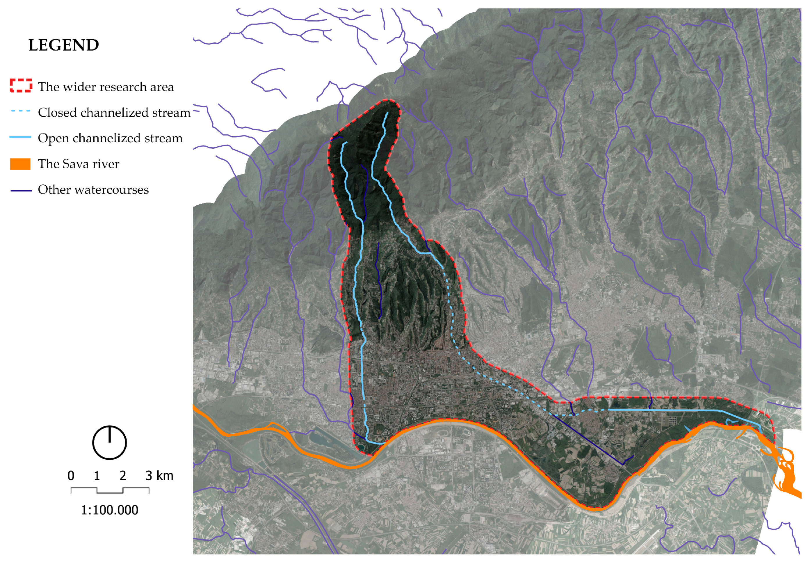
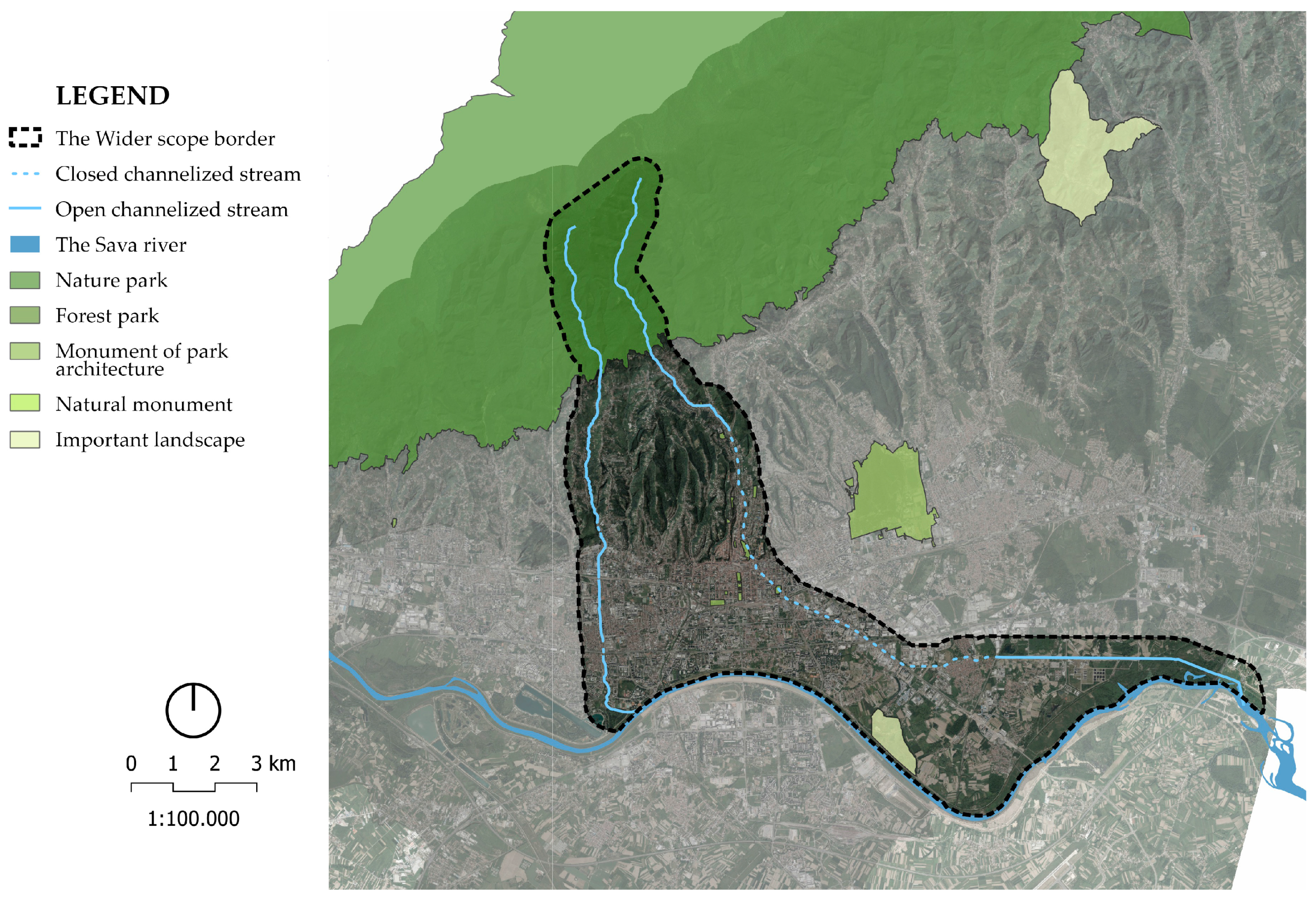
The research area is located in central continental Croatia (Figure 1), in the city of Zagreb, along the Črnomerec and Medveščak streams (Figure 2). They spring up on the southern slopes of the Medvednica mountain, flow through the Zagreb settlements north of the Sava, and into the Sava or the city’s sewage system. While collecting data on water levels, daily measurements from monitoring stations located on the streams were used, as well as measuring stations (Maksimir and Grič) in close proximity to the narrower scopes, to gather data on hydrometeorological conditions. The aim was to investigate the possibilities of using green and grey solutions along these streams. Regarding the characteristics of the riparian area, detailed inventories and structural analyses of natural and anthropogenic factors were conducted in both wider and narrower scopes. This study determined the possible application of sustainable NBSs, including the storage and purification of stream water and the protection and revitalisation of riverbeds. The wider scope included the area between 500 m west and east of the streams of Črnomerec and Medveščak, with the southern border being the Sava River and the northern border being 500 m from the line that connects the sources and 500 m east of the Medveščak stream. The two narrower scopes were defined by (a) an embankment area 200 m east and west of the Črnomerec stream, with the northern border being the edge of Nature Park Medvednica and the southern border being the northern bank of the Sava River, and (b) an area 200 m east and west of the Medveščak stream, with the northern border being the edge of Nature Park Medvednica and the southern border being the northern bank of the Sava River. Based on the boundaries of the Spatial Plan of the City of Zagreb [31] and the Spatial Plan of the Medvednica Nature Park [32], the narrow-scope area did not cover the streams within Nature Park Medvednica in order to reduce the negative impact on the protected landscape. Parts of the streams within the borders of Nature Park Medvednica were only marginally processed, with a focus on the lower parts that pass through the urbanised area of Zagreb. A part of the Medveščak stream was excluded from the narrow scope, while the area that passes south of Grada Vukovara Street and through the Borovje district to the banks of the Sava River was included.

2.2. Data Compilation

The starting points for the research were legal regulations, scientific and professional literature sources, articles, studies, projects, and realised applications that were collected and analysed. The work process included gathering information on the research area, as well as spatial data and cartographic documentation, which were synthesised and used to prepare and create a spatial database and spatial models and perform analyses, primarily using GIS tools [33]. To establish the cartographic and spatial database, a large portion of the spatial data were obtained from open sources (Table 1). All spatial data are recorded in the Croatian official reference coordinate system HTRS96/TM. The following georeference units were used: xMin, yMin 454812.50, 5068930.49, xMax, yMax 472009.65, 5084651.15.

2.3. Methodology

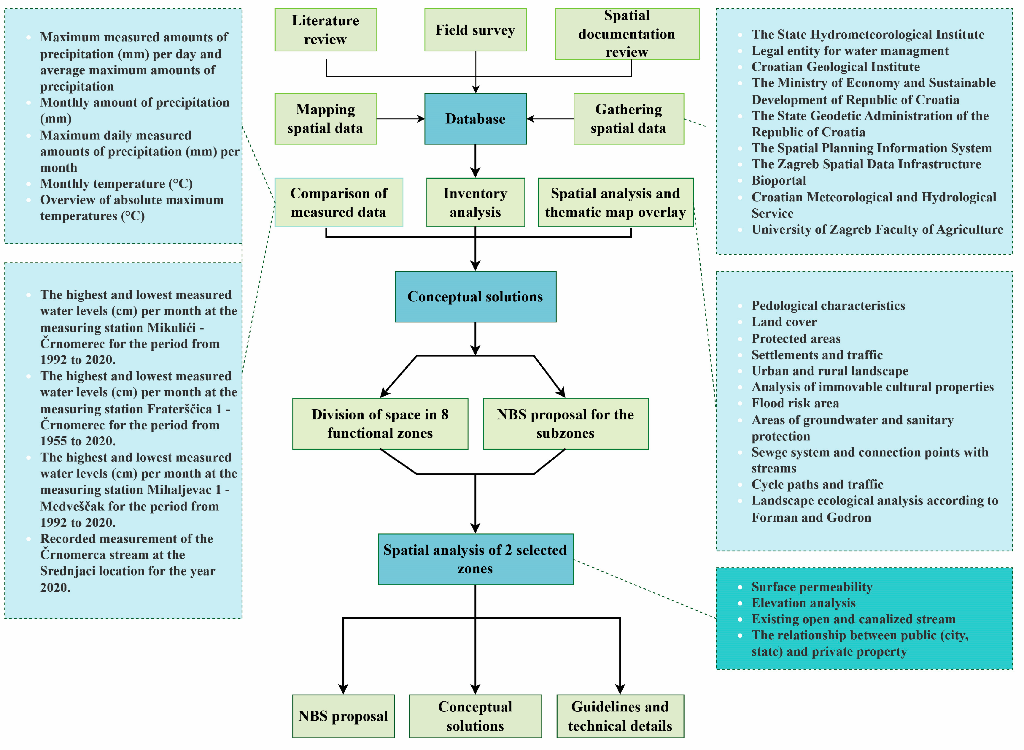
A field survey was conducted in August 2022 to note current spatial problems within the research area and to create spatial surveys for planning spatial guidelines. Data from measuring stations, including the daily water level, flow, temperature, and precipitation, were collected from the University of Zagreb Faculty of Agriculture, the State Hydrometeorological Institute, and the Legal entity for water management. Detailed analyses of graphs, which were created to display the extremes and trends in the last 70 or 30 years (depending on the start of measurements for the location), were conducted. QGIS 3.16., AutoCAD 2017, and Adobe Photoshop were used to perform various spatial analyses, including structural ecological analyses [34], riverbed and embankment analysis, terrain analysis, and communication analysis, of the collected data (Figure 3). The results of these analyses were used to create thematic models, zoning diagrams, concepts, guidelines, and technical details for application. Thematic models were created in GIS software (QGIS 3.16).

2.4. Description of the Physical Environment Based on Natural Factors

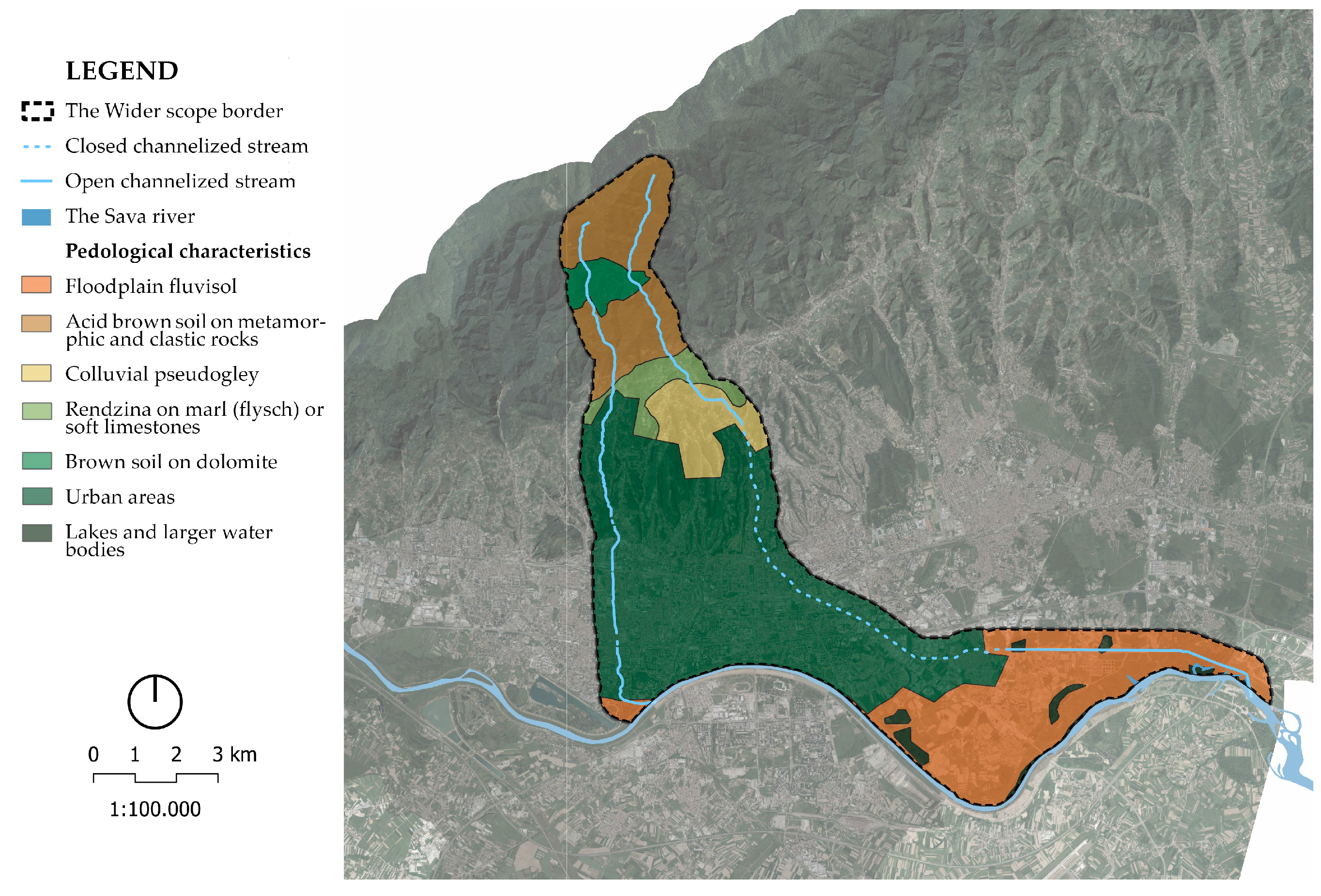
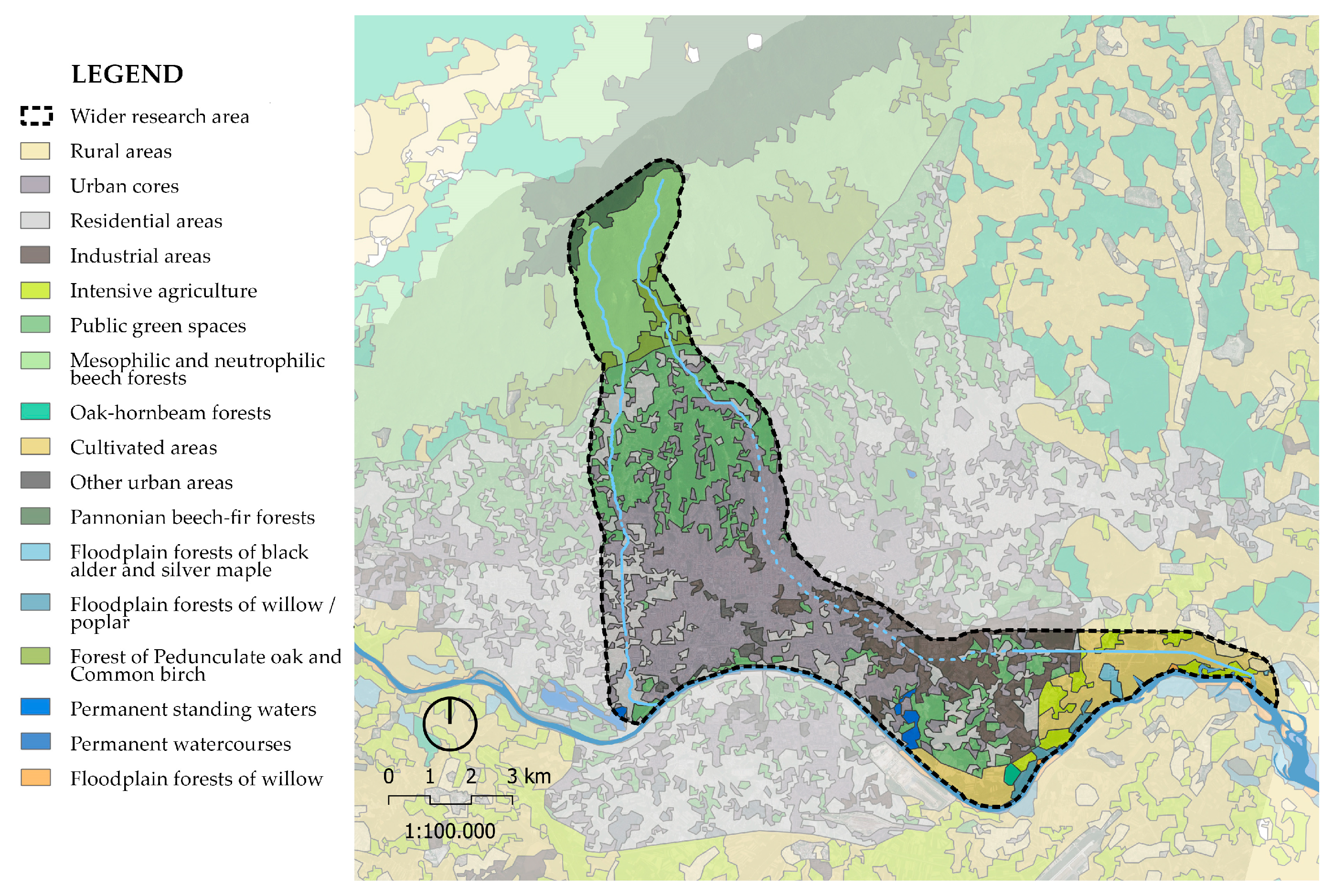
The city of Zagreb is located within the zone of influence of the Pannonian, Dinaric, and Alpine structures [35]. Several morphogenetic categories of relief occur in the area, including fluvial (such as the Sava valley), fluviodenudation (such as Medvednica with its southern foothill step), and karst and fluviokarst (such as Medvednica) [36]. On the southern slopes of Medvednica, a range of geological formations are represented, including metamorphic rocks from the Palaeozoic age, Mesozoic sediments, Neogene sediments, and Quaternary sediments [37,38]. Fourteen types of soil have been identified within the city [38]. These include alluvial (fluvisol) soils that are protected from floods, acid brown soils on metamorphic and clastic rocks, pseudogley soils on hillsides, rendzina soils on marl (flysch) and soft limestone, brown soils on dolomite, and some more (Figure 4). As the largest part of the area is occupied by settlements, it is necessary to carry out a detailed soil analysis. The city’s area is divided into Subpannonian and Pannonian landscape regions, which are further divided into six general landscape types that emphasise the connection between natural and anthropogenic components. These include the mountainous–hilly natural landscape of Medvednica, the hilly mixed landscape of Medvednica, the lowland urban landscape of Zagreb, the lowland riverine mixed landscape of Sava, the lowland rural landscape of Zagreb, and the hilly rural landscape of Zagreb (Figure 5). Due to its specific biogeographical position and diverse geology and geomorphology, anthropogenically influenced habitats predominate in the city’s area [39]. Unfortunately, natural habitats have been degraded due to the city’s expansion and various anthropogenic influences, resulting in a decrease in biological diversity. The Medvednica Nature Park is part of the Natura 2000 ecological network (Figure 6), and its area is defined and managed by the Medvednica Nature Park Management Plan [38].
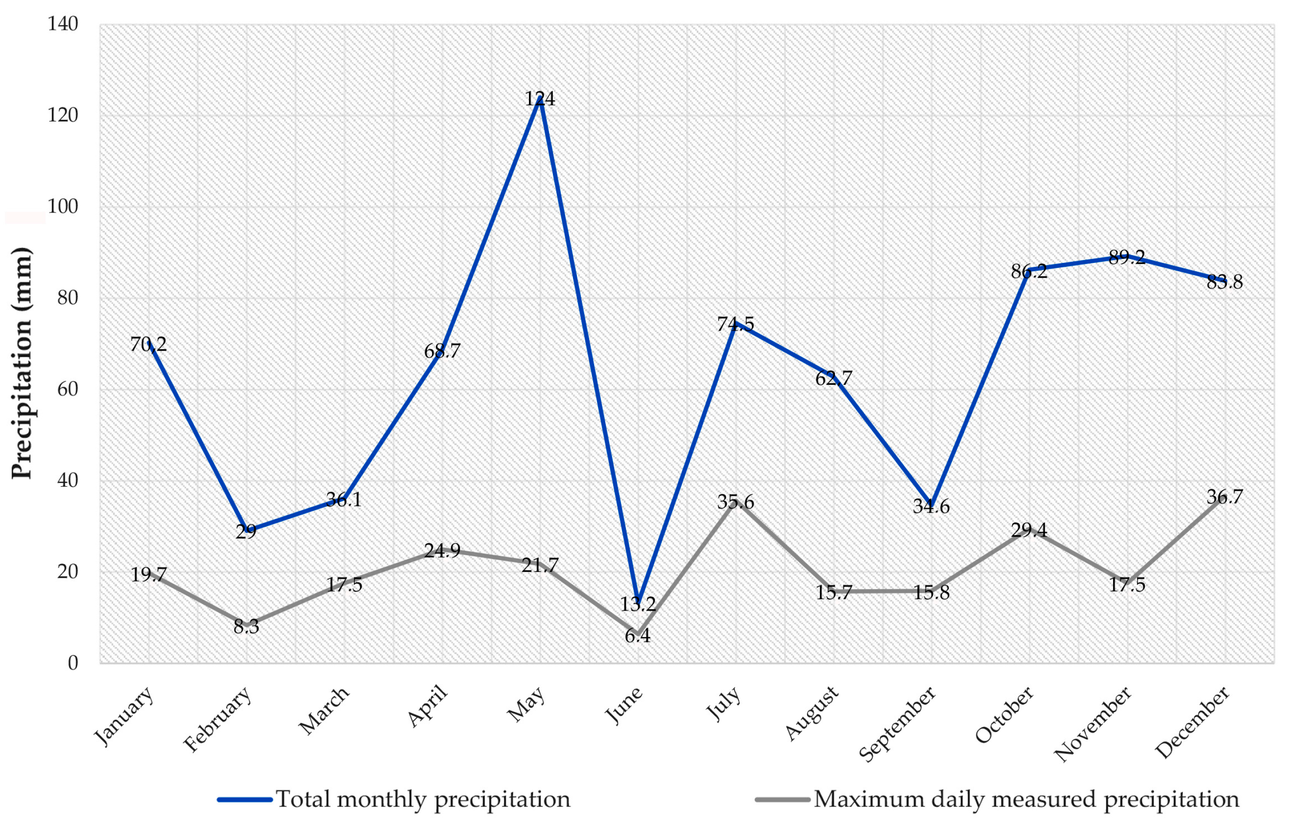
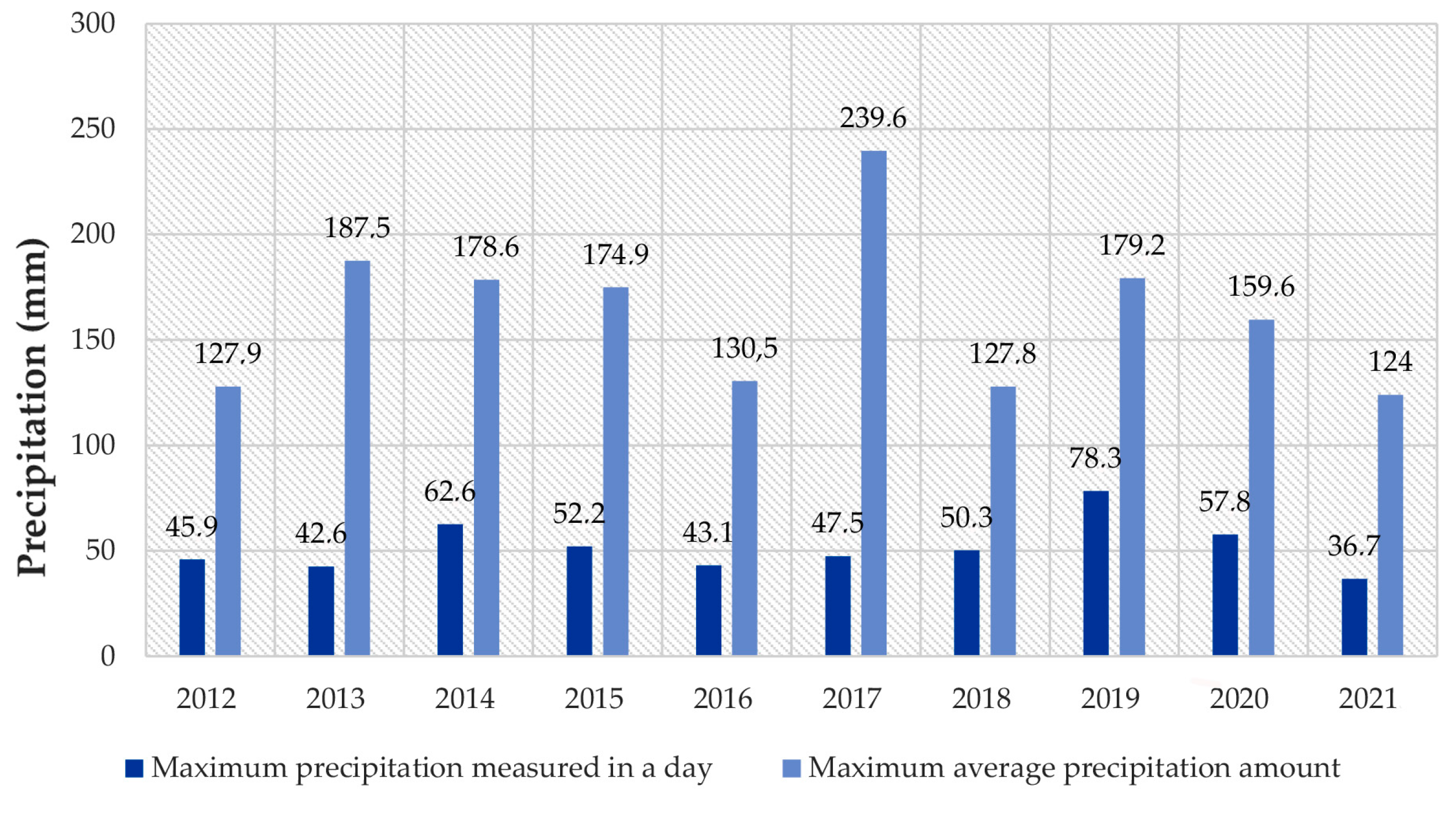
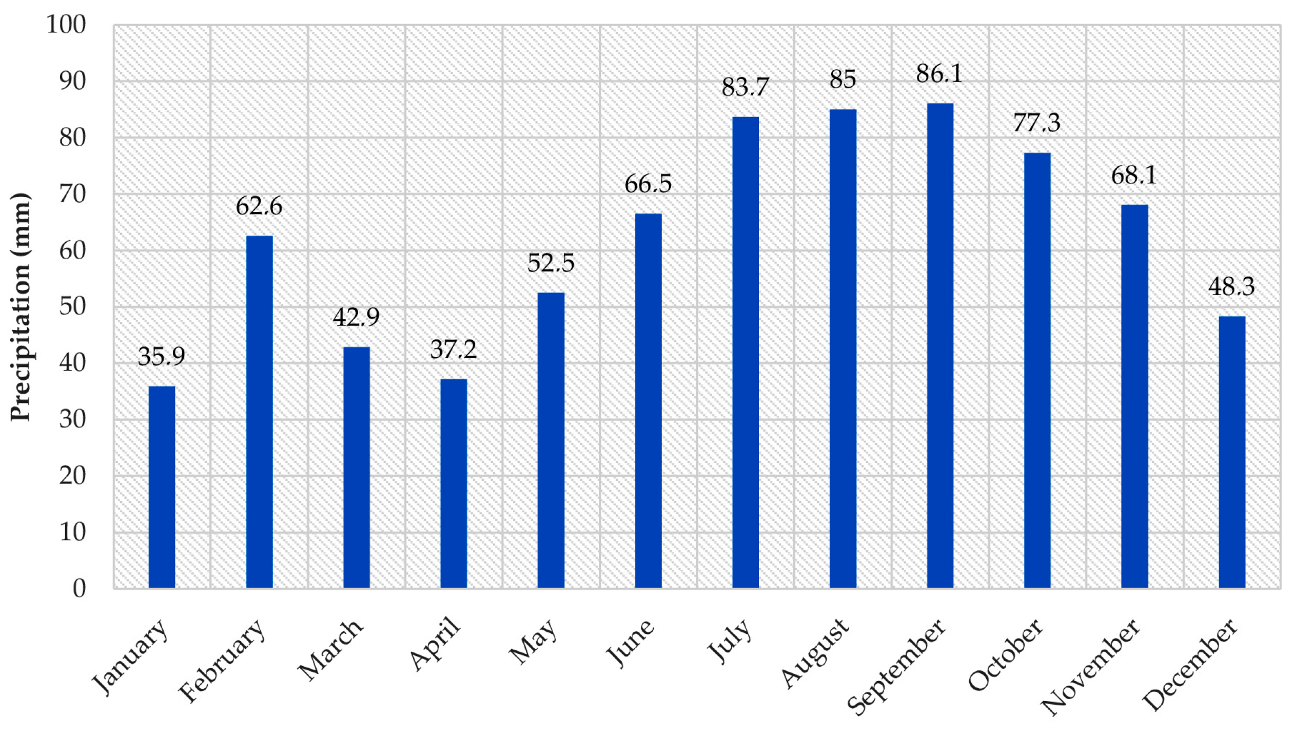
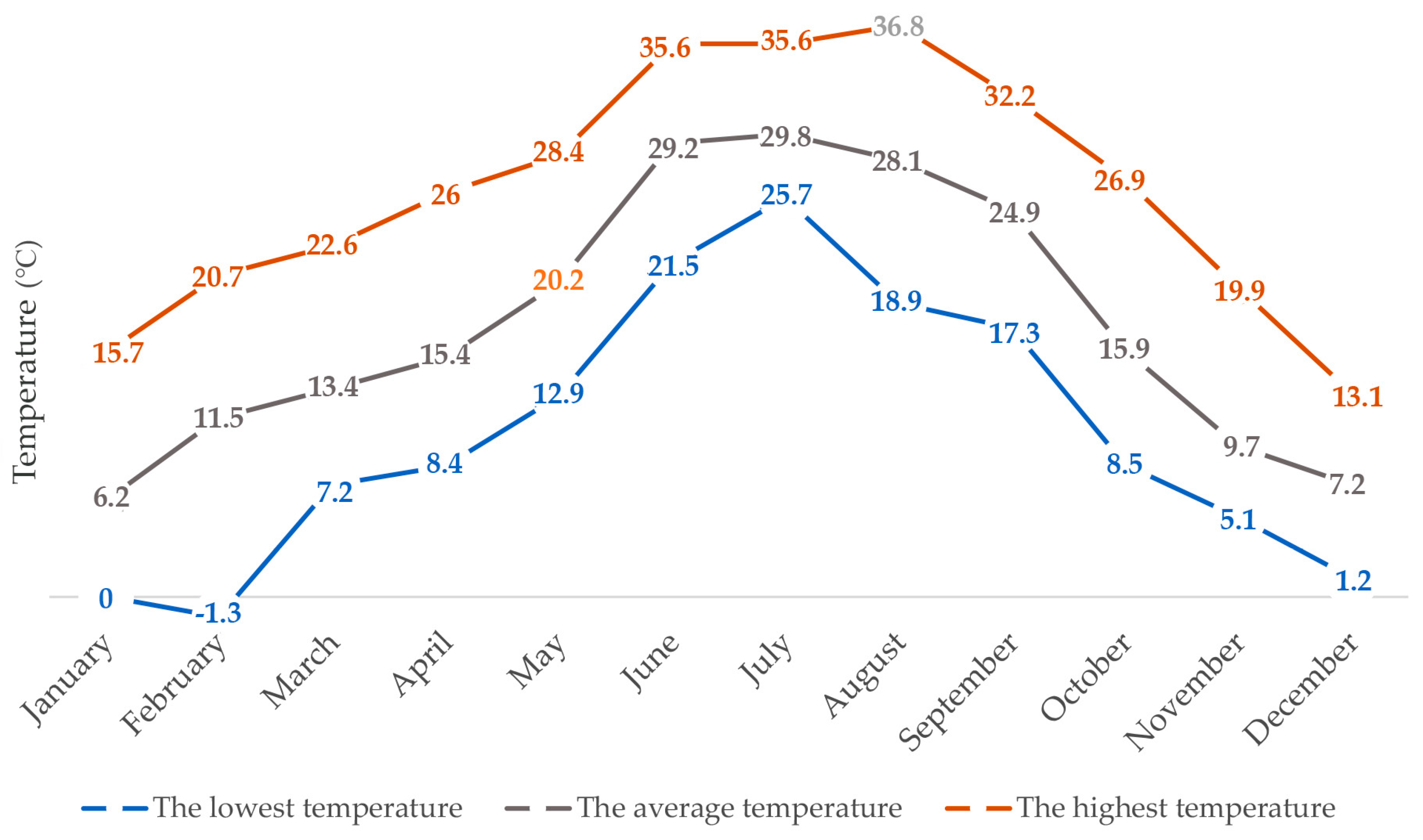
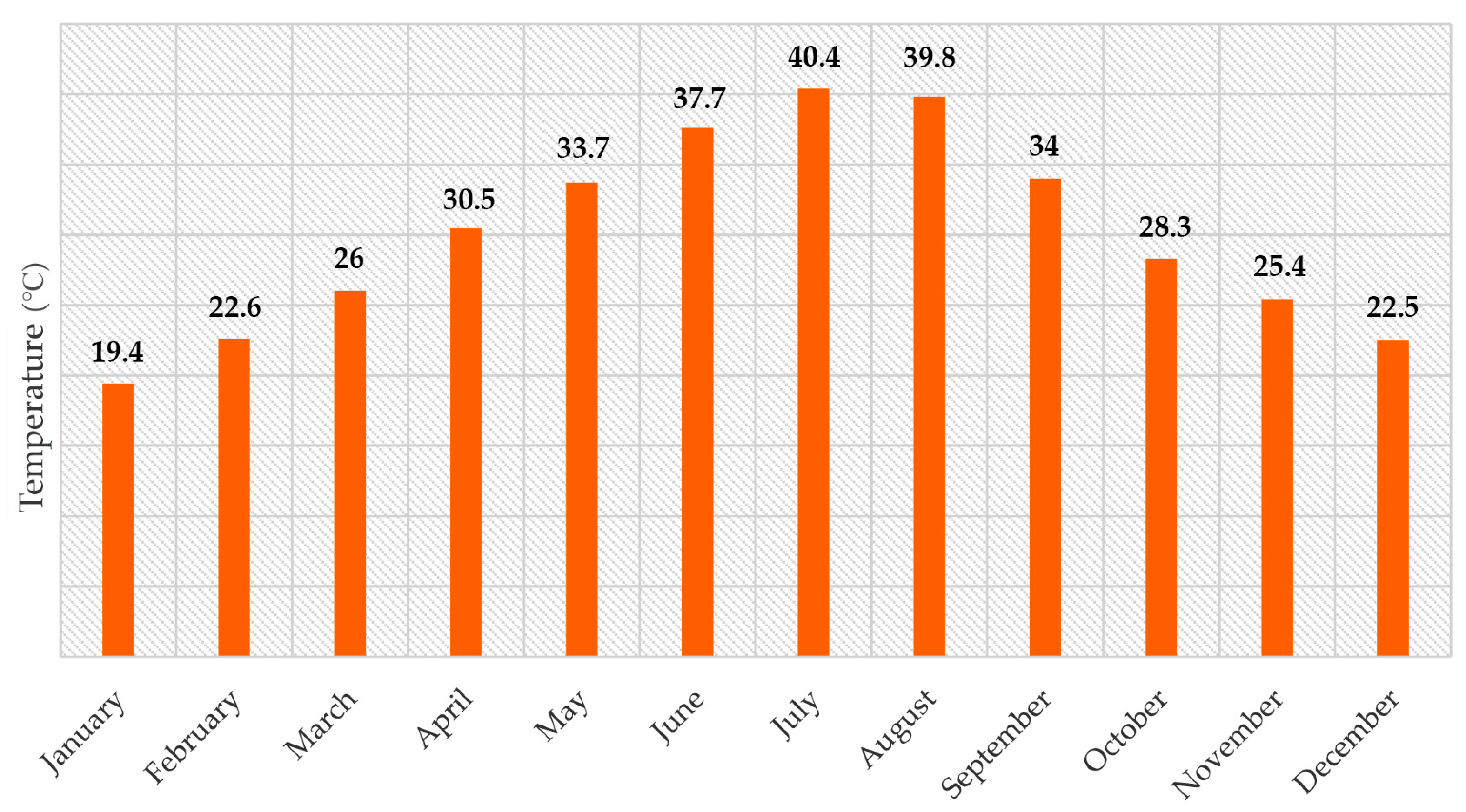
According to the Köppen classification, Zagreb has a moderately warm rainy climate, designated as Cfwbx [40]. Simulations of future climate changes in Croatia, according to the A2 scenario, predict a further increase in the concentration of carbon dioxide (CO2) in the atmosphere, resulting in a reduction of 45–50 mm in precipitation in Croatia from 2041 to 2070 [41,42]. In the period from January to December 2021 (Figure 7), the Maksimir measuring station recorded the highest precipitation in May (124.0 mm), while the highest daily amount of precipitation was measured on 3 December (36.7 mm), and the lowest was in June (13.2 mm). The analysis of extreme values within the last 10 years (Figure 8) of daily and monthly measurements revealed that the highest average amount of precipitation was measured in September 2017 (239.6 mm), while the highest daily amount of precipitation was measured on 24 September 2019 (78.3 mm). The highest amount of precipitation that fell in one day (Figure 9) was measured on 28 September 1987 (86.1 mm). Measurements of the most abundant amount of precipitation were recorded from July to October in the 70-year period. Regarding temperature measurements (°C) in the period from January to December 2021 at the Maksimir measuring station (Figure 10), the highest temperature of 36.8 °C was recorded in August, while the highest average temperature was recorded in July at 29.8 °C; the lowest temperature was in February at −1.3 °C, while the average lowest temperature was 6.2 °C in January of that year. The highest recorded temperature was measured on 5 July 1950 at 40.4 °C. It was established that in the 70-year period (Figure 11), the highest temperatures were recorded from May to September, but extremely high temperatures were also recorded in the colder part of the year, such as 25.4 °C measured on 16 November 1963 and 22.6 °C measured on 28 February 2019.
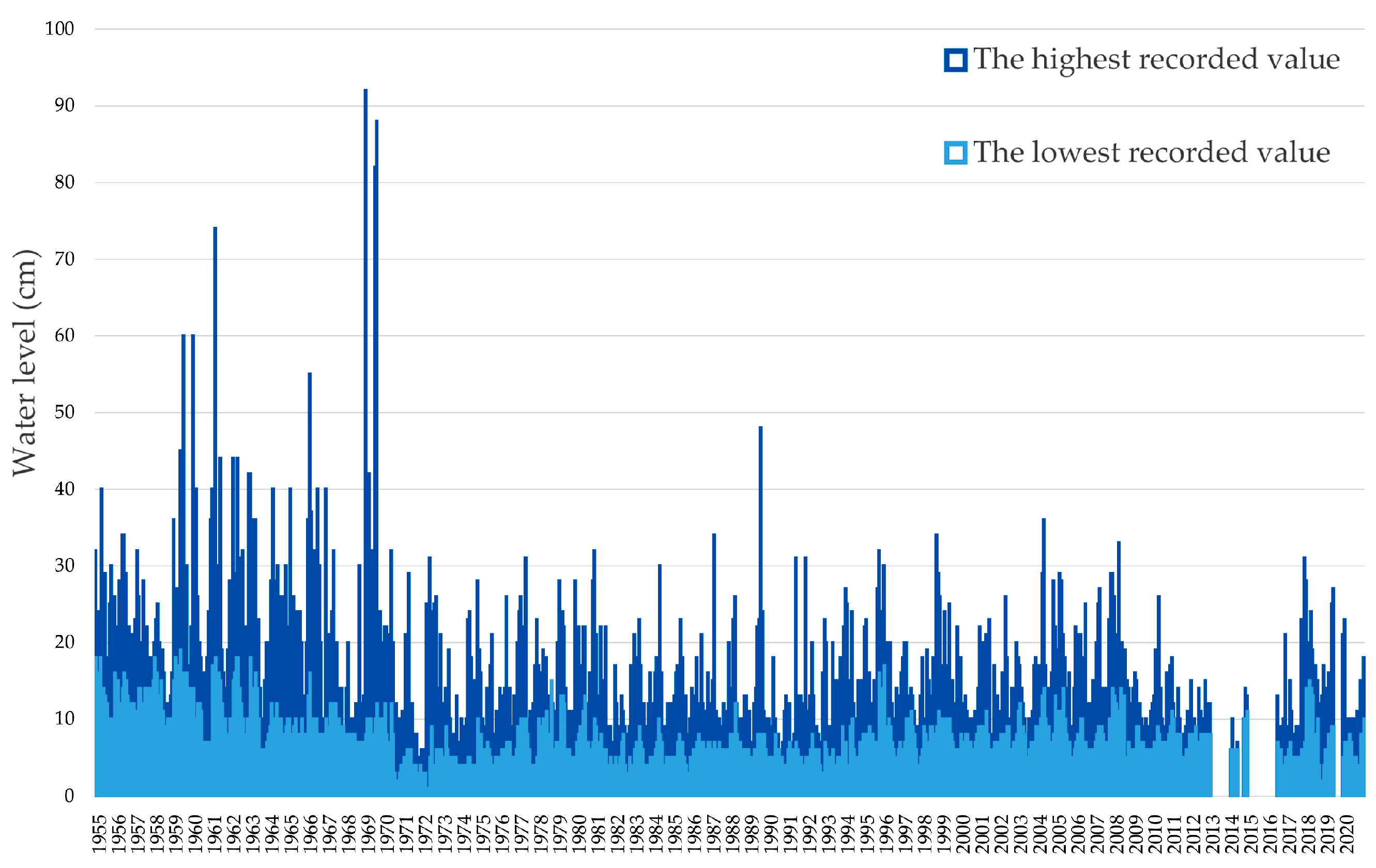
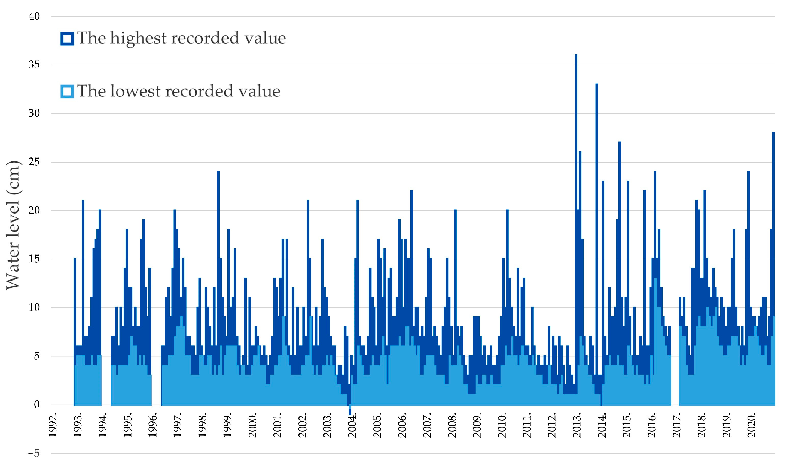
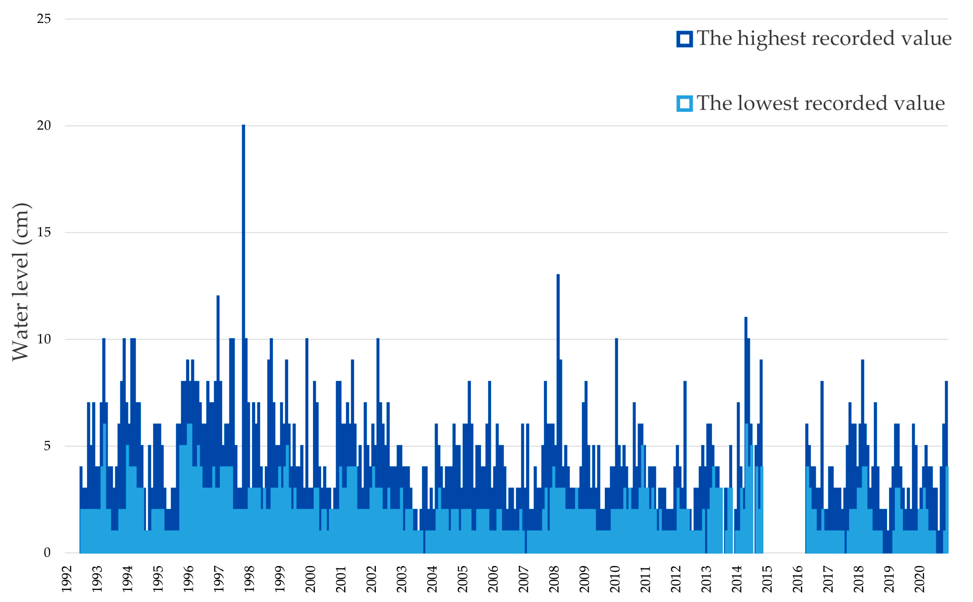
Zagreb’s streams spring from the Medvednica mountain and are part of the Sava River basin. Parts of them flow directly into the Sava (Črnomerec stream), and parts flow through the city’s drainage system (Medveščak stream). The streams can be divided into three basic parts, the upper, middle, and lower reaches, taking into account the hydrological characteristics of the streams themselves and the geomorphological processes along them (denudation and accumulation). However, the lack of measuring stations in the lower reaches of streams makes it difficult to collect data on their water levels and water flow. By comparing the measured water level data (cm) at the measuring station Fraterščica 1–Črnomerec (Figure 12), the differences in the height and position of the elevation were determined. Therefore, in the period 1959–1969, elevation “0” was at 128.600 m.a.s.l.; in 1970–1972, elevation “0” was at 148.181 m.a.s.l.; and in 1973–2020, elevation “0” was at 144.729 m.a.s.l. The highest measured water level, at a height of 92 cm, was recorded on December 18, 1968, and the lowest, at a height of 1 cm, was recorded several times during the measurements. However, data are missing for the whole year of 2013, June–August of 2014, December of 2014–May of 2016, and June–October months of 2019. According to the measured water level data (cm) at the measuring station Mikulići–Črnomerec (Figure 13), elevation “0” = 238.935 m.a.s.l. was recorded in the period 1992–2020, the highest measured water level of 36 cm was recorded on 21 January 2013, and the lowest, −1 cm, was recorded on 16 December 2003. However, data are missing for the periods January–November 1992, January–May 1994, January–April 1996, and October 2016–February 2017. Finally, according to the measured water level data (cm) at the measuring station Mihaljevac 1—Medveščak (Figure 14), elevation “0” = 194.542 m.a.s.l. was recorded in the periods 1992–2014 and 2016–2020, the highest measured water level, 20 cm high, was recorded on 13 November 1997, and the lowest, 1 cm high, was recorded several times. However, data are missing for the periods January–June of 1992, August of 2013 and 2014, December of 2013 and 2014, the entirety of 2015, and January–April of 2016.
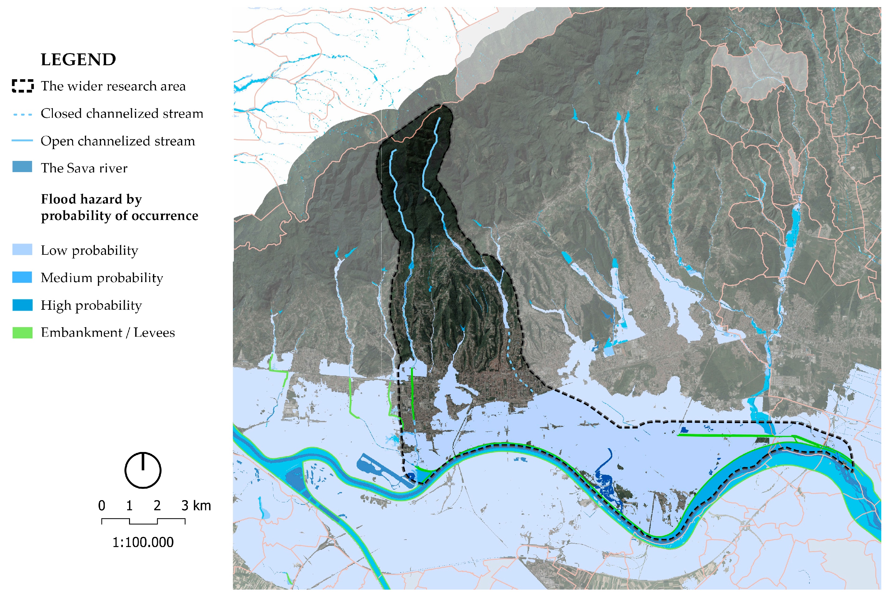
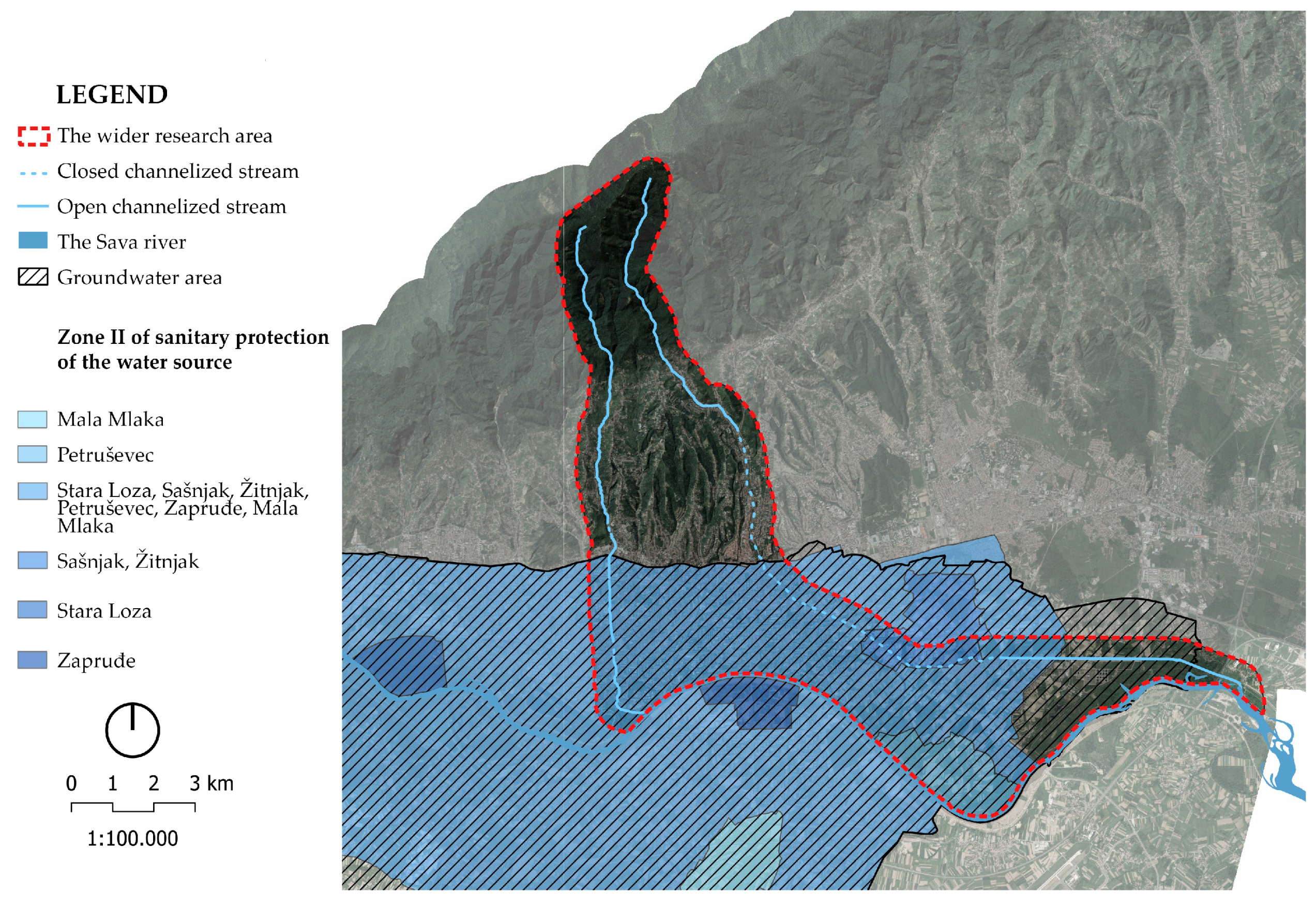
The city of Zagreb is protected from the 1000-year floods of the Sava basin (Figure 15), as well as from floods in streams that occur every 20 to 50 years, through the use of 19 mountain retentions [38]. The detailed measurement and determination of surface water and soil quality must precede the design [43,44]. Surface water quality measurements were conducted on the Črnomerec stream at the Srednjaci location [45]. The location is downstream from the pharmaceutical industry. The limit values of pollutant emissions were taken from the Rulebook on Limit Values of Wastewater Emissions [46]—limit values of wastewater emissions from buildings and plants from the pharmaceutical industry. In the Ordinance [46], there are no limit values for the amounts of calcium (mg/L), potassium (mg/L), magnesium (mg/L), and sodium (mg/L) measured. These values were taken from the Ordinance on compliance parameters, analysis methods, monitoring and safety plans for water for human consumption (Figure 16), and the method of keeping a register of legal entities that perform the activity of public water supply [47,48]. According to measurements, higher values of sodium (mg/L) were observed throughout the entire measurement period (Table 2).

2.5. Description of the Physical Environment Based on Anthropogenic Factors

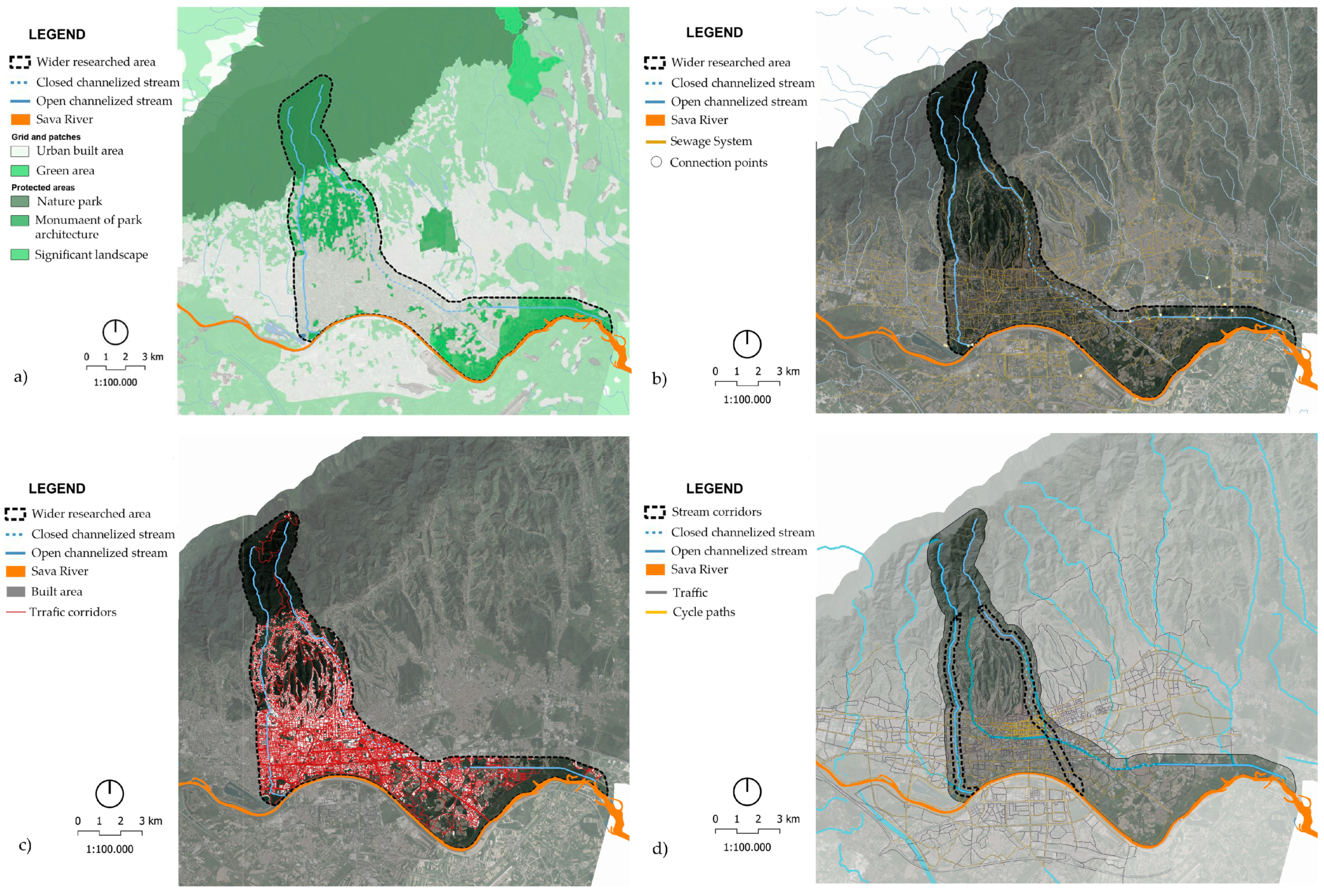
The city of Zagreb was developed in 1850 from two medieval settlements, Gradec and Kaptol, along the Medveščak stream [49]. For a long time, the development of the city remained on the slopes of Medvednica and the higher, unflooded parts of the Sava River valley. In the last hundred years, the increase in the number of inhabitants has led to a large expansion of built-up areas into the rural landscape of the Sava floodplain. After the great flood of 1964, a study on the regulation of the Sava River in Yugoslavia was prepared. It proposed a solution for flood defence and initiated the construction of the Odra relief canal [50]. The construction of the high embankment changed the image of the riparian landscape. Numerous backwaters and meanders disappeared. In the past, the Medveščak stream flowed openly all the way to the confluence with the Sava River in the Žitnjak district. Various trades, factories, and industries were opened along the stream. Due to a catastrophic flood in 1846, the Medveščak stream overflowed its banks and flooded many parts of the city. At the end of the 19th century, the Regulation of the Medveščak Stream was adopted, and the construction of the city sewer system began. Most of the mills and baths stopped working due to the regulation of the Medveščak stream from 1869 to 1898. The new embankment stretched along Medveščak street to Ribnjak until the 1930s when the Zagreb electric tram railroads were built above the closed channelised stream [51]. Today, the Medveščak stream flows in an open bed to Mihaljevac street, where it sinks into the city’s drainage system (Figure 17).

3. Results

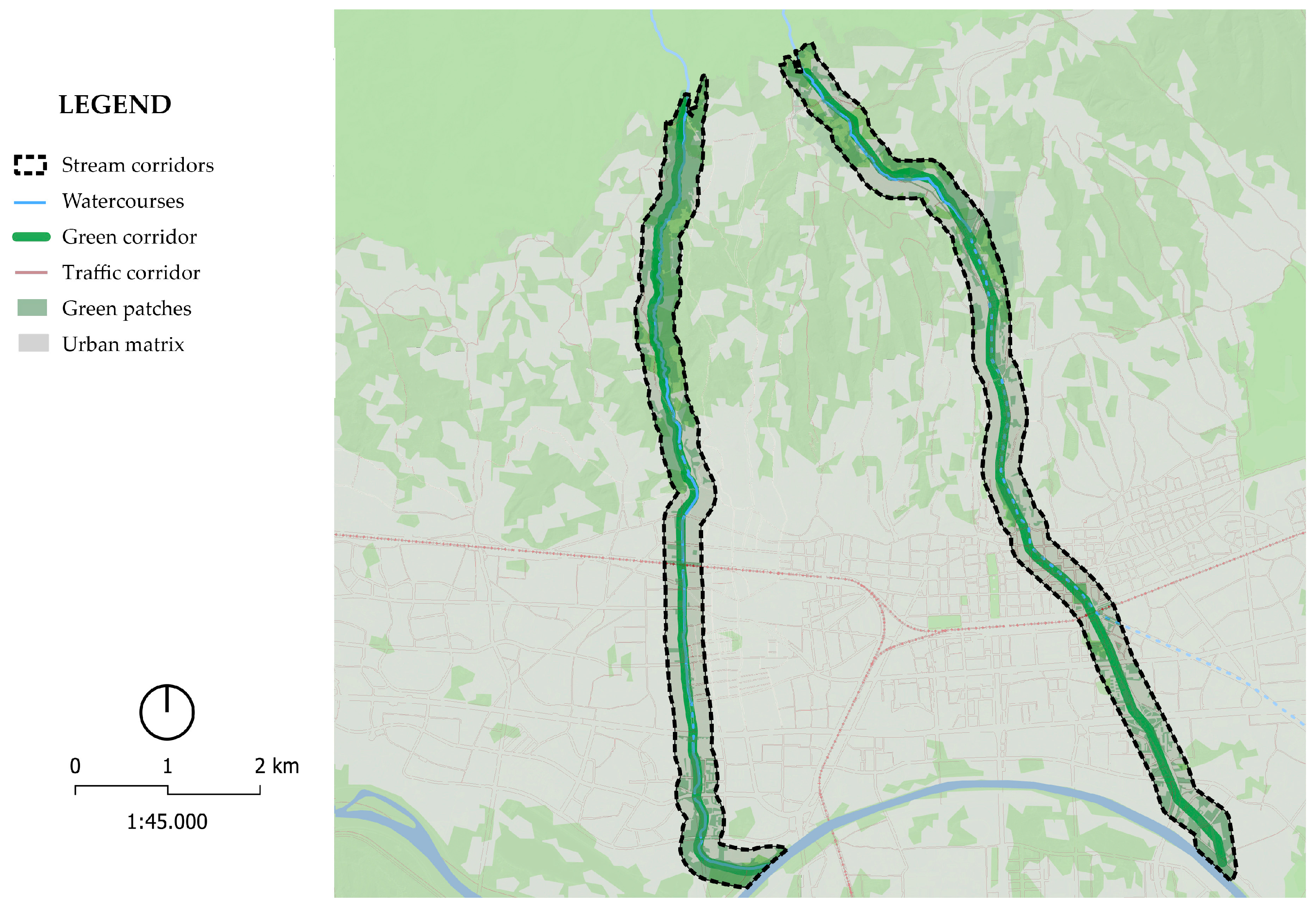
Structural ecological analysis reveals that the dominant urban matrix north of the Sava River, up to NP Medvednica, is divided into two distinct parts. The first part is a dense urban matrix situated in the lowland river area, while the second part consists of a higher-altitude matrix located in the hilly–mountainous area along the southern slopes of Medvednica. This second part is characterised by a complex mosaic of settlements, urban forests, parks, and agricultural plots. It is evident that the relief and morphological differences between the lowland river area and the hilly–mountainous area, as well as the anthropogenic influence, are the main features of the matrix and the landscape itself. The loss of green areas (patches) due to the expansion of urban areas, although defining the identity of the space, reduces its ecological quality. Green patches are of great ecological importance, serving as green stepping stones and corridors from NP Medvednica to the Sava River, which are currently interrupted. The anthropogenic influence in Zagreb has led to the loss of green areas, which, in turn, has reduced the ecological quality of the landscape. The analysis reveals two types of corridors, distinguished by their importance: anthropogenically conditioned corridors and natural corridors with anthropogenic influence. The former is represented by the E-W railroad, which cuts the streams into two parts, while the latter is represented by watercourses extending in the N-S direction and rivers extending E-W. Smaller traffic corridors branch off within the urban matrix, building its dense network and cutting through larger corridors, green patches, and the natural forest matrix of the NP Medvednica area (Figure 18). This hinders the movement of animals and the possible connection of green stepping stones. The edge between the natural forest matrix of the NP Medvednica area and the urban matrix of Zagreb is not clearly defined due to the gradual height difference, numerous smaller patches of forest, and agricultural areas within the settlement on the slopes of Medvednica. Anthropogenic edges of settlements along the edge of the forest predominate in the north of the observed area. Such edges are positive for urban spaces and the development of plant and animal communities within cities from an ecological point of view. They offer the possibility of migration between larger natural zones and the creation of natural microzones that have great benefits for fauna and the microclimate. However, they are also endangered due to the possibility of the uncontrolled expansion of built-up areas. Re-naturalising parts of streams and banks can create new green stepping stones. These would have important ecological features for flora and fauna in the city, as well as a positive impact on the microclimate, and improve the level of pollution in the soil, air, and water [52]. The formation of green corridors, along with blue corridors that penetrate the urban fabric, would allow the easier movement of fauna from the area of the forest matrix in NP Medvednica and smaller dense patches in the city to the north of the Sava and larger natural patches to the south of the Sava. This would improve the connectivity of green areas, making the landscape more hospitable to wildlife [53].
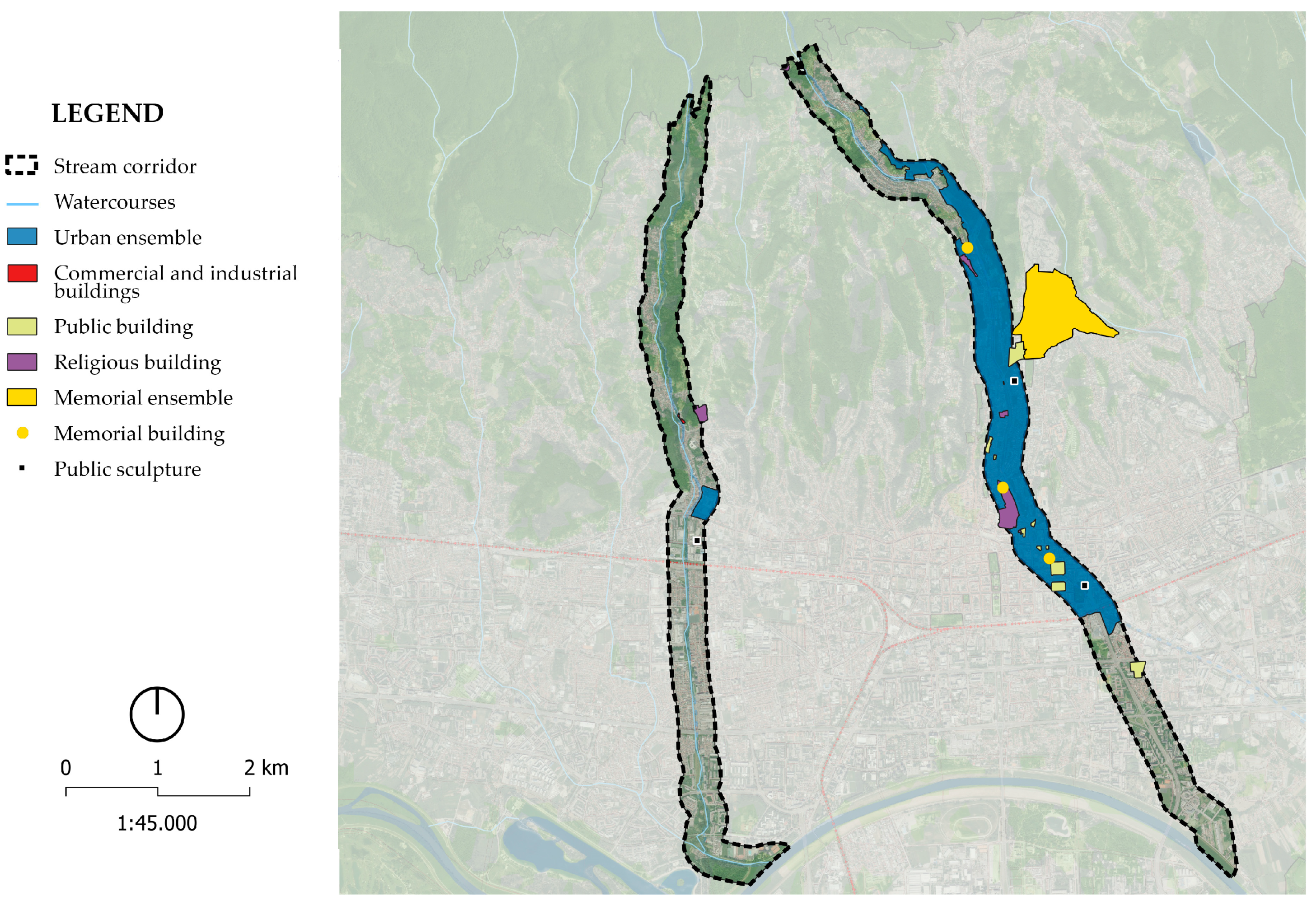
In the narrower scope along the Črnomerec stream, there are fewer protected areas and buildings compared to the area around the Medveščak stream (Figure 19). To the east of the Črnomerec stream, a part of the urban area of the city of Zagreb is protected. The protected urban area of the city of Zagreb covers the area above the Medveščak stream, which includes sacred buildings, such as the Zagreb Cathedral, as well as public buildings, sculptures, and urban equipment. The protected area also encompasses memorial buildings, among which the Mirogoj cemetery stands out as the largest unit. Therefore, especially in the case of the Medveščak stream, it is essential to consider the location and analysis of cultural assets as one of the fundamental bases for any unification or movement of the flow. This will help to avoid damaging any protected buildings or elements [54].
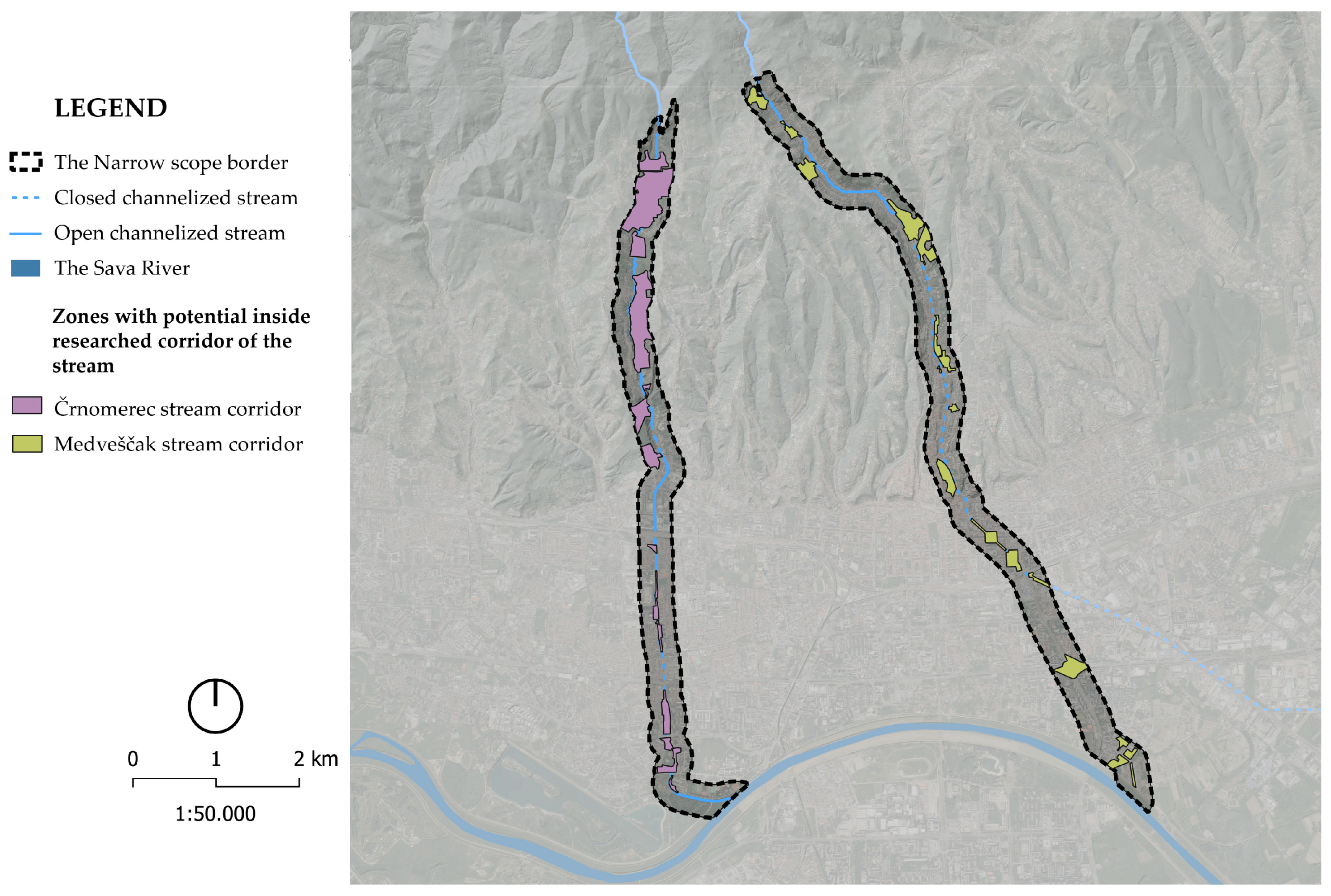
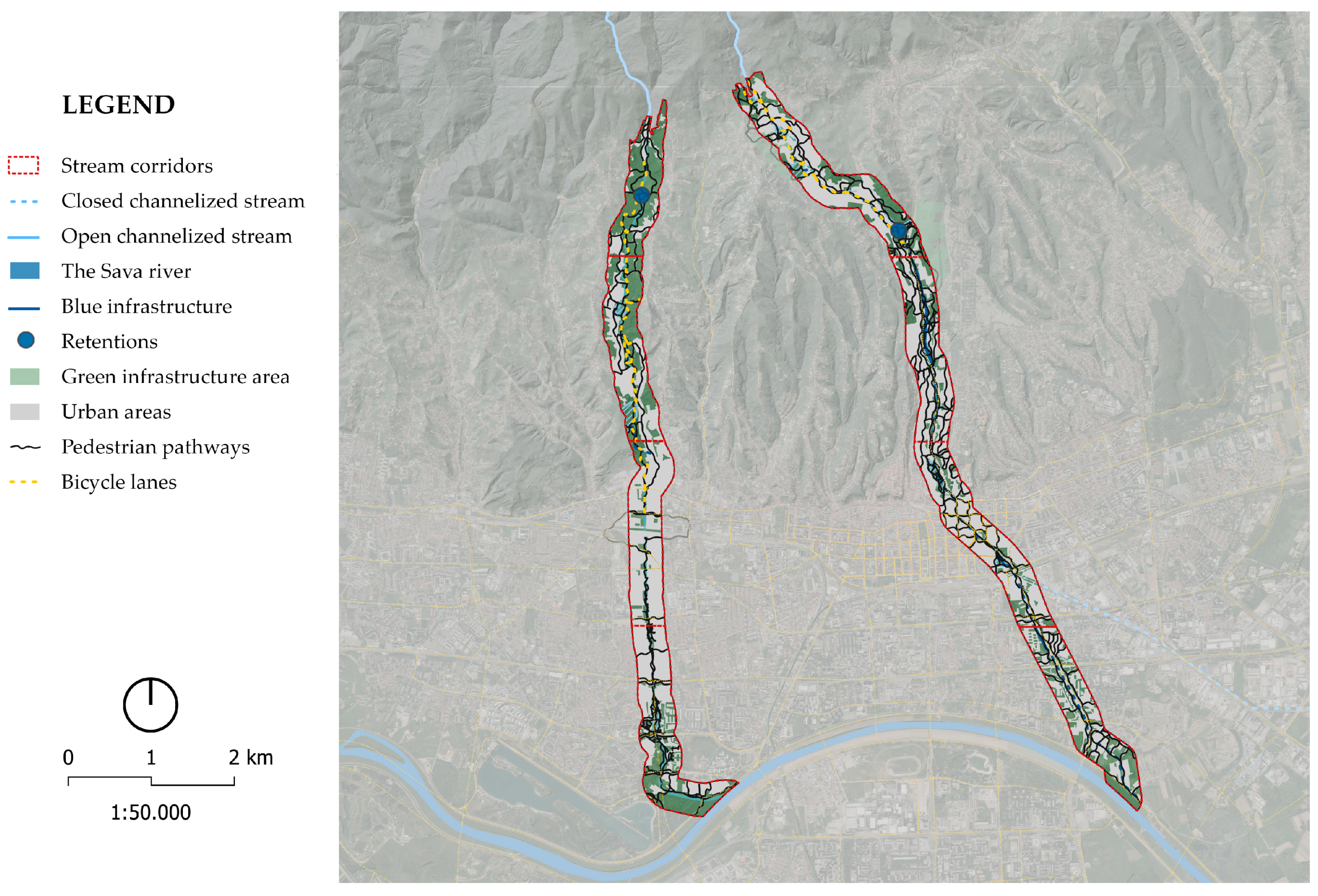
The remediation of stream water offers the possibility of creating a series of new services with the implementation of NBSs, in addition to the drainage of excess stormwater, i.e., torrential water (Figure 20). Additional services include residences, playgrounds, training grounds, and other educational and recreational services that can be accompanied by vegetation or water elements as a new riparian zone [55]. At the same time, restoring aquatic habitats requires mitigating the negative impact of rainwater that flows from polluted surfaces into aquatic habitats by purifying and applying phytoremediation [56,57]. Purified water can also be stored and used for irrigation during drought periods, which creates favourable microclimatic conditions [58]. Slowing down and mitigating the dangerous consequences of torrential water can be achieved by using NBS elements such as bioretention, rain gardens, infiltration ditches and tanks, buffer zones of dense vegetation, green facades and roofs, artificial wetlands, occasionally flooded zones, and wet meadows (Figure 21). This should be implemented alongside the existing blue corridor in the case of the Črnomerec stream and the modified blue corridor in the case of the Medveščak stream. Gradually, these park patches should be connected to the existing bicycle and pedestrian infrastructure. The approaches listed in Table 3 for each individual subzone are based on different NBS elements, selected according to the characteristics of each subzone and the possibility of implementation [59,60,61,62].
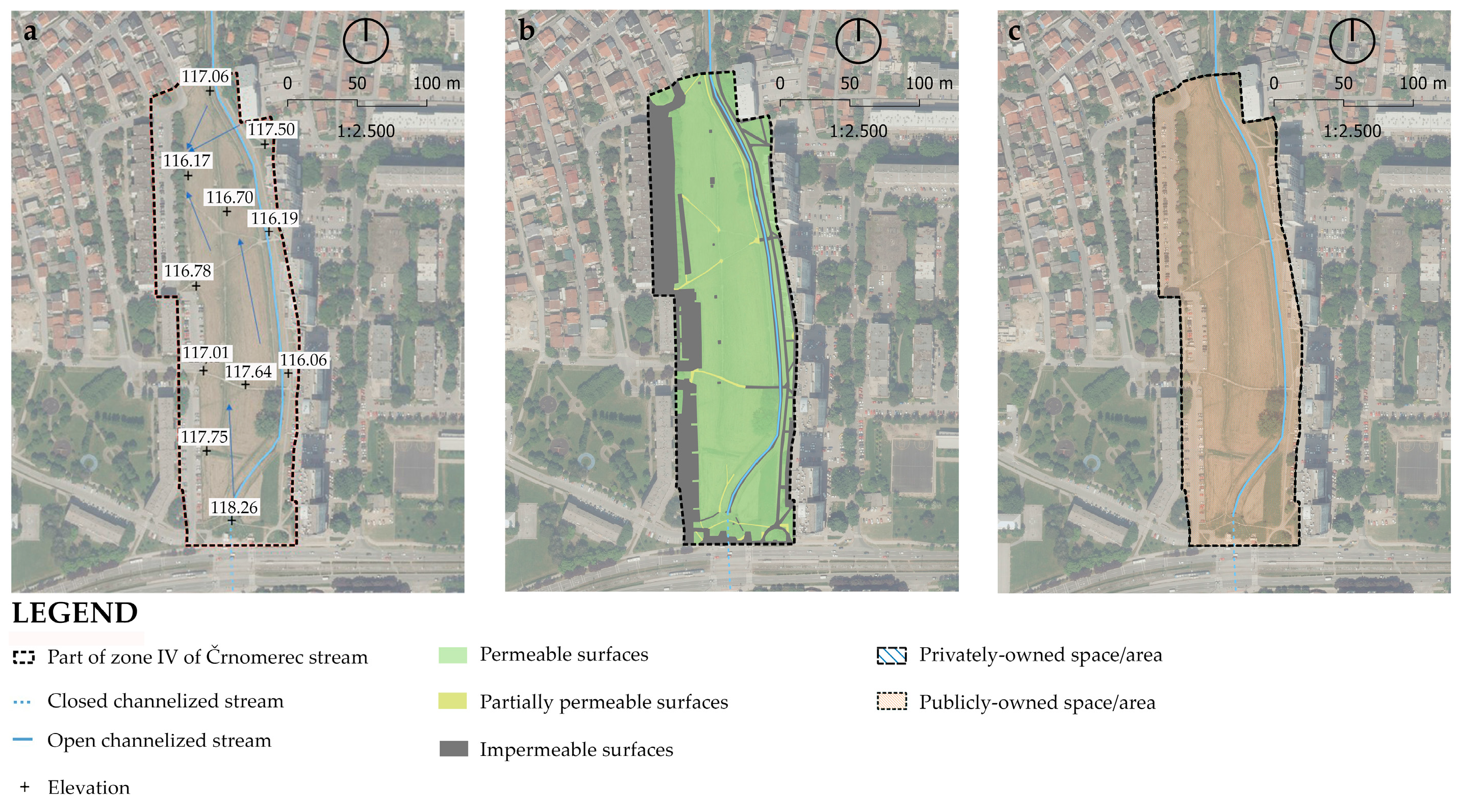
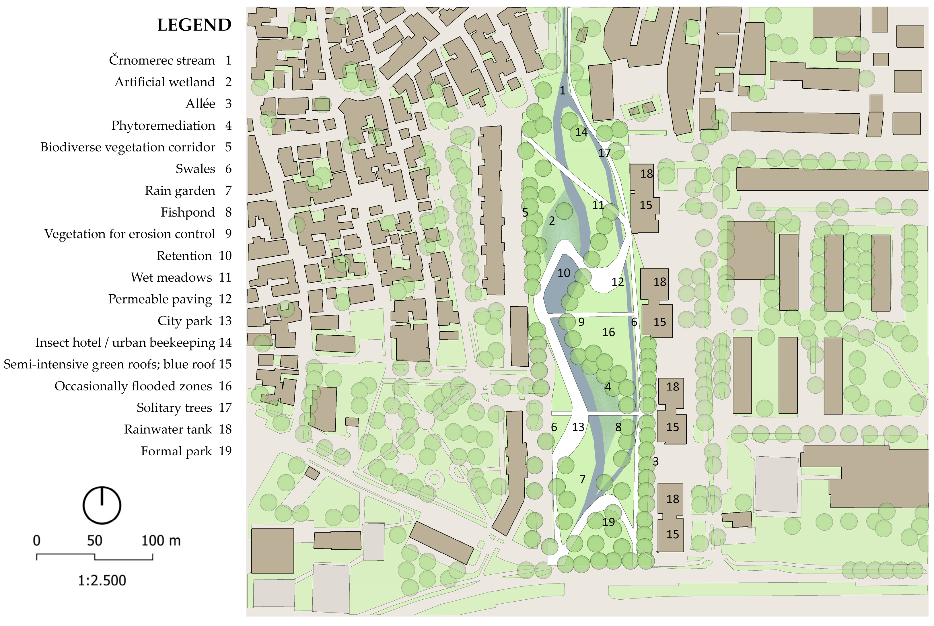
There are numerous adjoining areas with potential for NBS along the Črnomerec stream. In practice, the re-naturalisation of streams can be achieved through projects and concepts such as linear parks (greenways) (Figure 22). The greenway concept emphasises the conservation and improvement of biodiversity, recreation and stormwater management, the improvement of the quality of life and social equity, and the protection of the integrity of the landscape, including its natural and social components [63]. Given the complexity of the system (including sectorisation, unresolved legal and property relations, slow processes, and inconsistencies in spatial planning documents), only one zone was selected to create technical details, while the rest of the zones are covered in the guidelines (Figure 23). Most of the surfaces within the scope belong to the category of water-permeable surfaces. In addition to the marginal parts of the scope, there are formal paths, parking lots, curbs, and roads, which belong to the category of impermeable surfaces. Some of the impermeable surfaces can be replaced by permeable paving types. For new trails in the park, it is necessary to incorporate permeable paving types and underground tanks for collecting rainwater (Table 4).
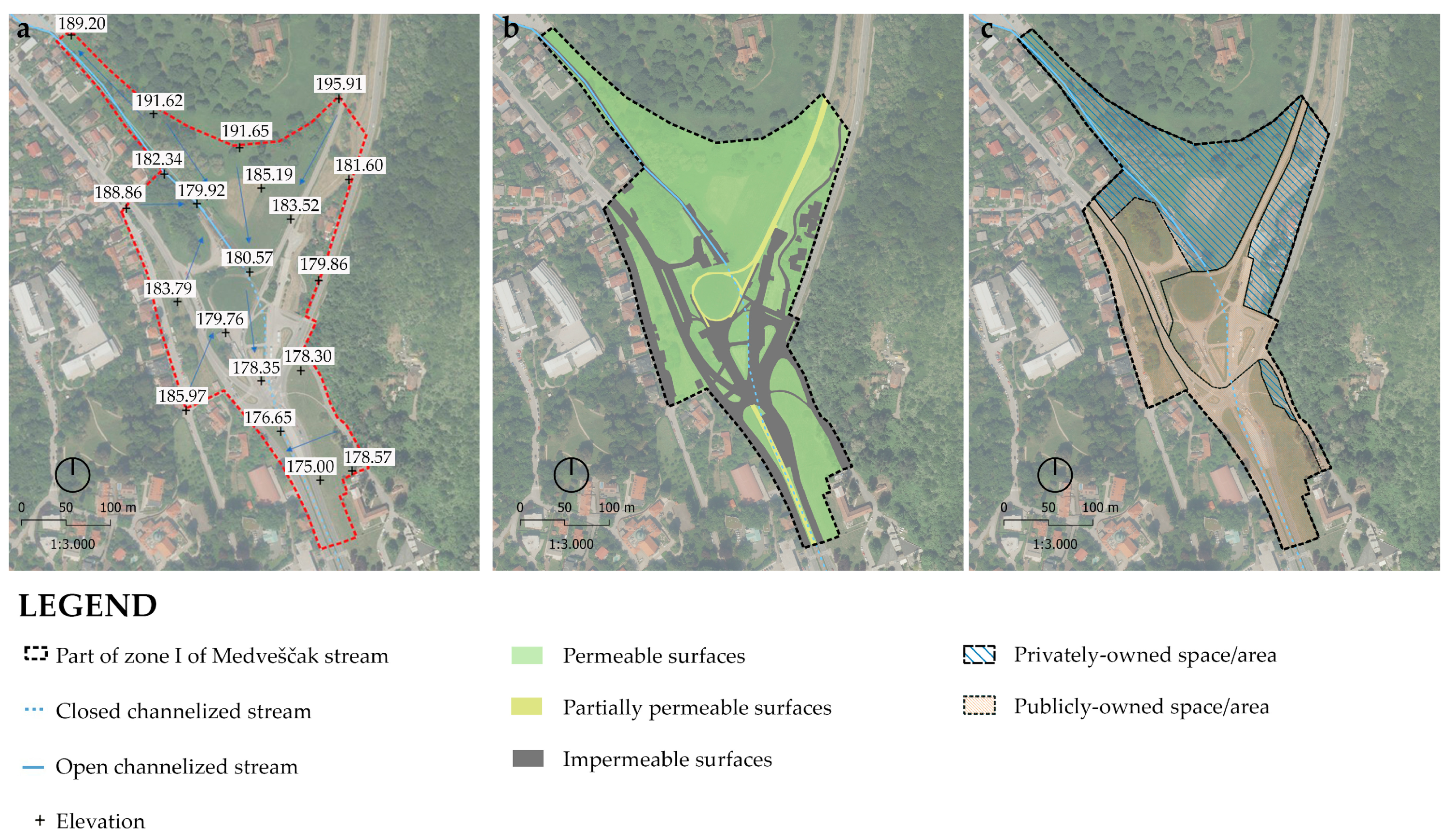
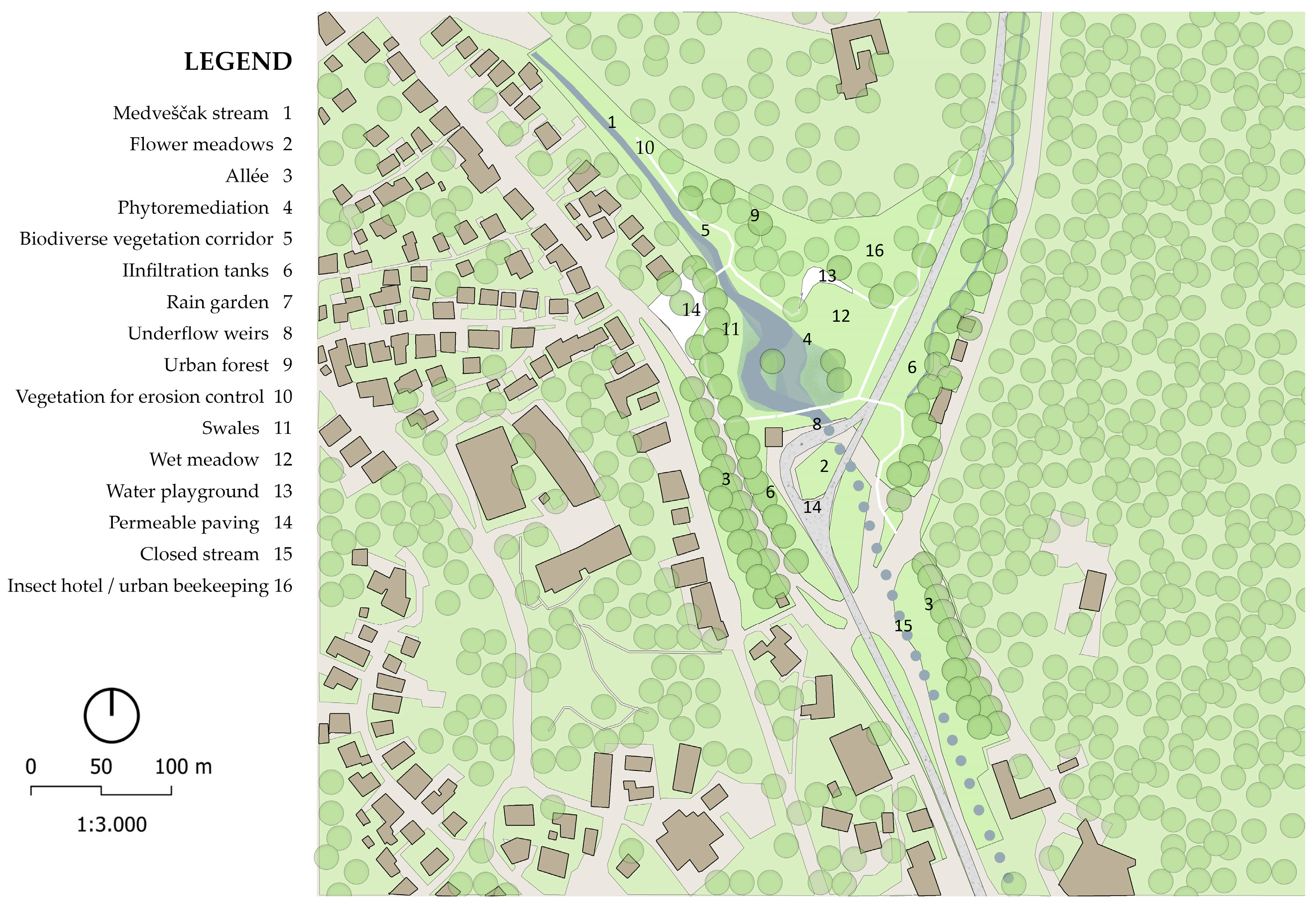
Unlike the Črnomerec stream, the Medveščak stream currently has fewer potential zones due to the narrow built-up edge that prevents expansion and opening (Figure 24). Given that the stream is closed and canalised under one of the city’s most important thoroughfares and has a two-way railway over it, it is necessary to consider the possibility of relocating the current infrastructure before conceptualising the opening of the riverbed. The daylighting of the Medveščak stream raises issues of private and public opinion on land use change. Additionally, the problem of connecting to the city sewerage system does not stop at Mihaljevac, as it also connects to several locations near the Žitnjak district. In the case of separating the stream pipeline from the sewage system [64], the separation should be planned along the entire flow. The specificity of the location is the slope, where excess rainwater flows south on impermeable surfaces and is directed into the city’s sewerage system, while all green and permeable surfaces are at a higher altitude. The tram line mostly comprises partially impermeable surfaces, i.e., surfaces with poor water permeability. A possible location proposed for the intervention is the upper area of the Medveščak stream, before being channelled underground (Figure 25). Some of the impermeable surfaces can be replaced by permeable paving types. For new residences in the park, it is necessary to incorporate permeable paving types and underground tanks for collecting rainwater and the possible implementation of other NBSs (Table 5).

Guidelines and Technical Details

(a)
When selecting vegetation, the analysis of the soil is necessary. Other characteristics, such as solitary, tree-lined, or grouped trees in combination with shrub species, soil-specific conditions, sunlight, drainage, sensitivity to urban conditions, insects and diseases, the value of the species in the habitat/ecological context, and the allergenicity and toxicity/edibility of the species, should be considered. When choosing a species, invasive species should be avoided, and autochthonous and non-native species should be preferred [65,66].
(b)
To ensure the success of phytoremediation at the location, it is necessary to sample and analyse the state of the water to select the most suitable species that will thrive in the location’s conditions according to the results of the analysis.
(c)
Rainwater tanks should be located below ground level, and a system for the purification, storage, and utilisation of rainwater is recommended. The modular elements of the system, which can be replaced in case of failure or cleaned in case of clogging, should be easily accessible. Therefore, it is suggested to use easily removable paving.
(d)
Wherever possible, green roofs and walls should be installed, and other public green areas for which the implementation of an irrigation system can be made and connected to rain tanks or an additional connection can be added to the water supply system in case of longer dry periods. In addition to these, it is necessary to ensure the possibility of implementing blue and brown roofs, which provide an additional view of specific habitats and the storage of a larger amount of rainwater, directly affecting the microclimate.
(e)
It is necessary to foresee occasionally flooded areas, wet meadows, and retentions into which excess water would flow and relieve the drainage system. The safe size of the surface required for overflow must be calculated and incorporated into the further elaboration and design of the space.
(f)
Ponds and artificial wetlands, as part of the blue infrastructure, can be in places where the natural cycles of ichthyofauna and flora will not be disturbed, i.e., where specific water locations already exist under different degrees of succession (proposed for Müller’s hill).
(g)
Parts of the stream bank where the concrete bed is removed must be protected from erosion by applying an erosion vegetation system or other ecological materials [67].
(h)
Water used for water elements in water playgrounds must meet EU standards. Therefore, it is necessary to regularly control the purified water and check the purification system.
(i)
Wherever possible, it is necessary to replace water-tight paving with water-permeable ones (gravel, mulch, porous concrete, etc.) and, by slowing down and holding back the flow of water, influence the creation of new habitats through micro-locations.
(j)
In the park area, it is necessary to provide shelter for insects and/or urban beekeeping in an undisturbed place.

4. Discussion

The growth in the number of inhabitants and built-up areas since the middle of the 20th century has had a negative impact on Zagreb’s waterways. The city that developed on the Medveščak stream lost its identity and a rich part of its history, which can still be read today from the toponyms of the immediate streets. Until recently, the streams in Zagreb have been viewed as a threat or obstacle to development, and they have been modified (such as paving the riverbed with concrete, overhanging, redirecting, connecting to the sewage system, etc.), while member states of the European Union and the rest of the world have long-standing practices of preserving, promoting, and restoring their social and ecological potential. Due to their direct mutual influence, a comprehensive analysis of the potential of the streams is necessary. According to the current General Urban Plan and Detailed Urban Plan, wherever possible, streams in Zagreb should be channelled through an open channel. Along the Črnomerec stream, it is possible to plan elements that will additionally protect and promote its ecological potential. This research showed that the complete restoration of the Medveščak stream is not possible. In addition, it is not possible to combine or relocate the stream, considering the dense urban area with a large number of protected buildings and limited area. So, it is necessary to protect the locations and immediate environments of cultural assets. Urban areas, although defining the identity of a space, diminish its ecological quality because they interrupt smaller forested areas in urban areas (city park forests, larger park areas, etc.) and green areas of significant ecological importance that act as green stepping stones and corridors from Nature Park Medvednica to the Sava River. The complete restoration of the two streams is not possible due to space limitations. Therefore, creating green and blue infrastructure connected to the stream will require a wider scope. Based on an overview of urban practice so far, the project should be developed through a multi-phase connection of smaller, more serviceable park patches with NBS elements within the urban matrix.
Green and grey solutions are a combination of natural and built systems. Natural systems include forests, floodplains, wetlands, and soils, which provide additional benefits for human well-being, such as flood protection and climate regulation. Traditional solutions for flood protection, i.e., grey infrastructure, only include dams, dikes, canals, storm surge dams, and structures that are often built of concrete and therefore accentuate problems such as flash floods. New integral approaches are being developed by introducing elements of green infrastructure within conventional systems. In different parts of the world, regarding problems and challenges in the field of application, approaches have different names. Therefore, the Chinese concept of the sponge city (SPc) is similar to American Low-Impact Development (LID) [68], the British Blue-Green Cities (BGCs) approach, the Australian Weather-Sensitive Urban Design (WSUD) [69], etc. To solve spatial problems in the territory of Croatia, it is necessary to adapt and apply elements that are suitable for the natural and anthropogenic factors of the selected location. Collecting excess rainwater and directing it for plantation irrigation reduces the need for manual watering and additionally benefits microclimatic conditions [70]. Vegetation is an important element of aquatic ecosystems and NBSs. Phytoremediation (Phytostabilization, Phytofiltration/Rhizofiltration, Phytovolatilization, Phytoextraction, Phytotransformation, and Phytostimulation) represents great potential as a non-destructive, economically acceptable, efficient, environmentally friendly, and safe alternative to conventional cleaning techniques for the revitalisation of water and surrounding soils [70,71,72,73]. The basic components of the wastewater treatment system using aquatic plants are substrate, aquatic plants, microorganisms, algae, and wastewater. The effectiveness of phytoremediation depends on the selected plant species and its characteristics (non-invasive, edible, quickly producing biomass, absorbing pollutants, etc.), the characteristics of water or soil pollutants, the root zone, environmental conditions, and the application of additives to improve the bioavailability and uptake of pollutants [74,75,76].
Given that the scope of this paper is located in the area of a densely branched hydrographic network of tributaries of the Sava River, the city of Zagreb is protected from the 1000-year floods of the Sava or from 20–50-year stream floods. Although the retention system on the slopes of Medvednica has not been fully completed, so the city is still at high risk of flooding, there has been a downward trend in the lower level to fall below the lowest annual water levels of the Sava and streams, i.e., lower than the bottom of the bed, and therefore the level of underground water. The water level and flow largely depend on the time of year, precipitation, and snowmelt on Medvednica. This is why the lower stream area often dries up in the warmer parts of the year. Simulations of future climate changes in Croatia, based on global climate models, predict a statistically significant decrease in precipitation until 2070. Therefore, it is necessary to consider alternative solutions in drainage systems for excess stormwater. Surplus water should be purified, stored, and used for irrigation during future periods of drought. Slowing down the water and mitigating the dangerous consequences of torrential water can be achieved by applying various NBS elements. NBSs utilise green elements such as permeable surfaces, absorption wells, canals, grass ditches, accumulation and retention lagoons/lakes, bioretention systems, underground retention plant devices, rain gardens, infiltration ditches, infiltration tanks, denudations, green and blue roofs, green walls, rain tanks, etc. These solutions work in six phases: infiltration of rainwater, retention and detention of rainwater, and purification, utilisation, and controlled release of excess water. For example, replacing impervious surfaces with permeable paving surfaces ensures the percolation of excess water. The detention of rainwater during more abundant periods reduces the risk of floods and torrential water, and retaining the water leads to its accumulation in systems that have the role of purifying and applying collected water during drier periods. Slowing down and retaining the runoff of excess precipitation reduces the risk of soil erosion and the load on grey infrastructure, which has a positive impact on the duration and maintenance costs of grey infrastructure.

5. Conclusions

The problem of stream revitalisation has been re-evaluated due to the lack of open areas for the expansion and restoration of the natural processes of the riverbed and banks. This especially applies to the Medveščak stream because of its limitation by buildings. Several point solutions have been proposed to achieve an uninterrupted blue–green stretch, with the relocation of the Medveščak stream from Mihaljevac to the Sava River being offered as the most successful solution. In contrast to the Medveščak stream, the Črnomerec stream does not represent a difficult spatial planning challenge for the realisation of an ecological corridor. This is because it is still almost entirely open and surrounded by green areas with the potential for repurposing and establishing various NBS facilities. Along with the closure, riverbed paving, and canalisation of the stream, the problem of water and surrounding soil pollution was identified, for which a phytoremediation measure was proposed. Guidelines for the possible revitalisation and transformation of watercourses, including technical details on connecting grey, green, and blue infrastructure, were described for two smaller zones with high potential for development. The re-naturalisation of parts of the stream, the restoration of water habitats, the formation of green corridors alongside blue corridors, and the rehabilitation of stream water through purification and the application of phytoremediation offer the possibility of creating a series of new services in addition to the defence against and drainage of excess storm water. A multi-phase arrangement of smaller multi-service park patches with NBS elements along the existing (Črnomerec) or newly formed (Medveščak) blue corridor is proposed. Additionally, to improve the quality of traffic infrastructure in the city area, it is necessary to enable bicycle and pedestrian communication along with blue and green infrastructure. This would speed up the safe movement of people and animals from NP Medvednica to the Sava River. The corridors along the streams have the potential to serve as ecological corridors through the urban matrix between the Medvednica Nature Park and the Sava. Green roads with developed pedestrian and bicycle communication represent the greatest potential. Based on the results obtained from the review of spatial documentation, a detailed description of the location, and the analyses carried out, together with the geological structure, hydrological, and climatic conditions, it was established that the area includes no significant risks of long-term droughts and extreme floods.
According to EU policies, strategies, laws, and plans, an integrated approach that combines grey and green solutions was chosen to dispose of excess rainwater, manage water bodies, and maintain public green areas. The approach incorporates existing grey infrastructure and traditional flood protection solutions as part of a complex system that offers multiple services in addition to flood protection. The green component of the solution reduces the burden and cost of maintaining conventional infrastructure, mitigates the risk of flash floods and drought, purifies water, slows down water flow, provides a habitat for flora and fauna, improves microclimate conditions, enhances air quality, offers spaces for educational and recreational activities, and adds aesthetic and economic value. By applying NBSs, the Medveščak and Črnomerec streams have the potential to create pleasant microclimates, enhance biodiversity, improve water and air quality, promote resource efficiency, ensure public safety, enhance public health and well-being, support educational and residential zones, facilitate cycling and pedestrian communication, and add aesthetic, visual, and economic value. A system based on nature can be used to solve numerous spatial problems, but the planning of the system should be preceded by the detailed measurement of the number of pollutants and the determination of the quality of the surface water, soil, and air. In addition, the establishment of a systematic inventory and valorisation of flora and fauna is necessary so that a high-quality system of protection and sustainable use of the biological diversity of the city of Zagreb can be applied and established during planning and design. When zoning, selecting content, designing, and implementing individual subzones, it is necessary to include public participation through information provided via a bottom-up approach and participatory tools, such as websites, printed informational material and newspapers, surveys, multi-day educational sessions, workshops, and public debates. This is important for raising the population’s awareness of investing in blue and green infrastructure, gathering specific knowledge about the location from the local population, and making informed decisions for the location, thus creating a sense of belonging, inclusiveness, and social equality.

Author Contributions

Conceptualisation, M.J. and M.K.; methodology, M.J., D.T.R. and M.K.; software, M.J. and M.K.; formal analysis, M.J.; investigation, M.J. and M.Z.; resources, M.B.K.; data curation, M.J., M.Z. and M.B.K.; writing—original draft preparation, M.J., D.T.R. and M.K.; writing—review and editing, M.J., D.T.R., M.K. and P.P.; visualisation, M.J. and M.K.; supervision, D.T.R. and P.P.; project administration, M.K. and D.T.R. All authors have read and agreed to the published version of the manuscript.

Funding

This research received no external funding.

Institutional Review Board Statement

Not applicable.

Informed Consent Statement

Not applicable.

Data Availability Statement

The data that support our research findings are available from the corresponding author on request.

Conflicts of Interest

The authors declare no conflict of interest.

References

  1. Williams, G.P.; Wolman, M.G. Downstream Effects of Dams on Alluvial Rivers. Geological Survey Professional Paper. 1984. Available online: https://pubs.usgs.gov/pp/1286/report.pdf (accessed on 5 July 2022).
  2. Turconi, L.; Tropeano, D.; Savio, G.; Bono, B.; De, S.K.; Frasca, M.; Luino, F. Torrential Hazard Prevention in Alpine Small Basin through Historical, Empirical and Geomorphological Cross Analysis in NW Italy. Land 2022, 11, 699. [Google Scholar] [CrossRef]
  3. Booth, D.B.; Bledsoe, B.P. Streams and Urbanization. In The Water Environment of Cities; Baker, L., Ed.; Springer: Boston, MA, USA, 2009. [Google Scholar] [CrossRef]
  4. Ahern, J. From fail-safe to safe-to-fail: Sustainability and resilience in the new urban world. Landsc. Urban Plan. 2011, 100, 341–343. [Google Scholar] [CrossRef] [Green Version]
  5. Naiman, R.J. Socio-ecological complexity and the restoration of river ecosystems. Inland Waters 2013, 3, 391–410. [Google Scholar] [CrossRef]
  6. Marttila, M.; Kyllönen, K.; Karjalainen, T.P. Social Success of In-Stream Habitat Improvement: From Fisheries Enhancement to the Delivery of Multiple Ecosystem Services. Ecol. Soc. 2016, 21, 4. Available online: http://www.jstor.org/stable/26270319 (accessed on 22 May 2022). [CrossRef] [Green Version]
  7. European Commission: A Blueprint to Safeguard Europe’s Water Resources. Brussels, 2012, COM(2012)673 Final. Available online: https://www.eea.europa.eu/policy-documents/a-blueprint-to-safeguard-europe2019s (accessed on 20 August 2022).
  8. Potočki, K.; Vouk, D.; Kuspilić, N. Smanjenje Rizika od Poplava u Urbanim Sredinama Pomoću Integralnih Zelenih Rješenja (Reduction of Flood Risk in Urban Areas with Integral Green Solutions).VII. Conference of Croatian National Platform for Disaster Risk Reduction. Zagreb, Croatia. 2018; pp. 70–75. Available online: https://civilna-zastita.gov.hr/UserDocsImages/CIVILNA%20ZA%C5%A0TITA/PDF_ZA%20WEB/Zbornik%20sazetaka%20VII_konf.pdf (accessed on 18 June 2022).
  9. Krvavica, N.; Jaredić, K.; Rubinić, J. Methodology for defining the design storm for sizing the infiltration system. Građevinar 2018, 70, 657–669. [Google Scholar] [CrossRef]
  10. European Commission. Directorate-General for Research and Innovation, Evaluating the Impact of Nature-Based Solutions—A Handbook for Practitioners; Publications Office of the European Union: Luxembourg, 2021; Available online: https://op.europa.eu/en/publication-detail/-/publication/d7d496b5-ad4e-11eb-9767-01aa75ed71a1/language-en (accessed on 28 June 2022).
  11. Agaton, C.B.; Guila, P.M.C. Ecosystem Services Valuation of Constructed Wetland as a Nature-Based Solution to Wastewater Treatment. Earth 2023, 4, 78–92. [Google Scholar] [CrossRef]
  12. Sowińska-Świerkosz, B.; García, J. What are Nature-based solutions (NBS)? Setting core ideas for concept clarification. Nat. Based Solut. 2022, 2, 100009. [Google Scholar] [CrossRef]
  13. Vierikko, K.; Niemelä, J. Bottom-up thinking—Identifying socio-cultural values of ecosystem services in local blue–green infrastructure planning in Helsinki, Finland. Land Use Policy 2016, 50, 537–547. [Google Scholar] [CrossRef]
  14. Alikhani, S.; Nummi, P.; Ojala, A. Urban Wetlands: A Review on Ecological and Cultural Values. Water 2021, 13, 3301. [Google Scholar] [CrossRef]
  15. Blau, M.L.; Luz, F.; Panagopoulos, T. Urban River Recovery Inspired by Nature-Based Solutions and Biophilic Design in Albufeira, Portugal. Land 2018, 7, 141. [Google Scholar] [CrossRef] [Green Version]
  16. O’Briain, R.; Shephard, S.; McCollom, A.; O’Leary, C.; Coghlan, B. Plants as agents of hydromorphological recovery in lowland streams. Geomorphology 2021, 400, 108090. [Google Scholar] [CrossRef]
  17. Yin, D.; Chen, Y.; Jia, H.; Wang, Q.; Chen, Z.; Xu, C.; Li, Q.; Wang, W.; Yang, Y.; Fu, G.; et al. Sponge city practice in China: A review of construction, assessment, operational and maintenance. J. Clean. Prod. 2021, 280, 2. [Google Scholar] [CrossRef]
  18. Song, C. Application of nature-based measures in China’s sponge city initiative: Current trends and perspectives. Nat. Based Solut. 2022, 2, 100010. [Google Scholar] [CrossRef]
  19. Zhao, Y.; Xia, J.; Xu, Z.; Qiao, Y.; Shen, J.; Ye, C. Impact of Urbanization on Regional Rainfall-Runoff Processes: Case Study in Jinan City, China. Remote Sens. 2023, 15, 2383. [Google Scholar] [CrossRef]
  20. Budge, T. Sponge Cities and Small Town: A New Economic Partnership. The Changing Nature of Australia’s Country Towns; Victorian Universities Regional Research Network Press: Ballarat, Australia, 2005; pp. 38–52. [Google Scholar]
  21. Qi, Y.; Chan, F.K.S.; Thorne, C.; O’Donnell, E.; Quagliolo, C.; Comino, E.; Pezzoli, A.; Li, L.; Griffiths, J.; Sang, Y.; et al. Addressing Challenges of Urban Water Management in Chinese Sponge Cities via Nature-Based Solutions. Water 2020, 12, 2788. [Google Scholar] [CrossRef]
  22. Hu, S.; Yue, H.; Zhou, Z. Preferences for urban stream landscapes: Opportunities to promote unmanaged riparian vegetation. Urban For. Urban Green. 2018, 38, 114–123. [Google Scholar] [CrossRef]
  23. Lara, Á.; Moral, L.D. Nature-Based Solutions to Hydro-Climatic Risks: Barriers and Triggers for Their Implementation in Seville (Spain). Land 2022, 11, 868. [Google Scholar] [CrossRef]
  24. Zhang, J.; Han, Y.; Qiao, X.-J.; Randrup, T.B. Citizen Willingness to Pay for the Implementation of Urban Green Infrastructure in the Pilot Sponge Cities in China. Forests 2023, 14, 474. [Google Scholar] [CrossRef]
  25. Radinja, M.; Atanasova, N.; Zavodnik Lamovšek, A. The water-management aspect of blue-green infrastructure in cities. Urbani Izziv 2021, 32, 98–110. [Google Scholar] [CrossRef]
  26. Brown, A.G.; Lespez, L.; Sear, D.A.; Macaire, J.; Houben, P.; Klimek, K.; Brazier, R.E.; Van Oost, K.; Pears, B. Natural vs anthropogenic streams in Europe: History, ecology and implications for restoration, river-rewilding and riverine ecosystem services. Earth-Sci. Rev. 2018, 180, 185–205. [Google Scholar] [CrossRef]
  27. Gašparović, S.; Sopina, A.; Zeneral, A. Impacts of Zagreb’s Urban Development on Dynamic Changes in Stream Landscapes from Mid-Twentieth Century. Land 2022, 11, 692. [Google Scholar] [CrossRef]
  28. Levi, P.S.; McIntyre, P.B. Ecosystem Responses to Channel Restoration Decline with Stream Size in Urban River Networks. Ecol. Appl. 2020, 30, 1–17. Available online: https://www.jstor.org/stable/26932472 (accessed on 1 June 2023). [CrossRef] [PubMed]
  29. Barvidienė, O.; Šaulys, V. Naturalization Processes in the Beds of Regulated Rivers. In Proceedings of the 9th International Conference on Environmental Engineering, Vilnius, Lithuania, 22–24 May 2014. [Google Scholar] [CrossRef] [Green Version]
  30. Hu, Y.; Gao, L.; Ma, C.; Wang, H.; Zhou, C. The Comprehensive Reduction Capacity of Five Riparian Vegetation Buffer Strips for Primary Pollutants in Surface Runoff. Appl. Sci. 2023, 13, 3898. [Google Scholar] [CrossRef]
  31. Institute for Spatial Planning of the City of Zagreb, Zagreb, Croatia. Prostorni Plan Grada Zagreba. 2014. Available online: https://www.zzpugz.hr/wp-content/uploads/2015/02/PPGZ_ID_2014_knjiga2.pdf (accessed on 26 April 2023).
  32. Ministry of Physical Planning. Construction and State Assets, Zagreb, Croatia. Prostorni Plan Parka Prirode Medvednica. 2014. Available online: https://mpgi.gov.hr/o-ministarstvu-15/djelokrug/prostorno-uredjenje-3335/prostorni-planovi-8193/prostorni-planovi-drzavne-razine/prostorni-planovi-parkova-prirode/prostorni-plan-pp-medvednica/3393 (accessed on 26 April 2023).
  33. QGIS Development Team. GIS Geographic Information System. Open Source Geospatial Foundation. 2022. Available online: http://qgis.org (accessed on 18 June 2023).
  34. Forman, R.T.T.; Godron, M. Landscape Ecology; John Wiley and Sons Ltd.: New York, NY, USA, 1986. [Google Scholar]
  35. Bralić, I.; Aničić, B.; Koščak, V.; Bužan, M.; Sošić, L.; Jurković, S.; Gašparović, S.; Kušan, V.; Dumbović-Bilušić, B.; Furlan-Zimmermann, N.; et al. Studija Krajolik, Sadržajna i Metodska Podloga Krajobrazne Osnove Hrvatske; University of Zagreb, Faculty of Agriculture, Department of Ornamental Plants and Landscape Architecture: Zagreb, Croatia, 1999. Available online: https://mpgi.gov.hr/UserDocsImages/Zavod/Publikacije/Krajolik-knjiga-web.pdf (accessed on 29 June 2022).
  36. Buzjak, N.; Pahernik, M.; Bočić, N.; Butorac, V.; Martinić, I. Georaznolikost i geobaština Grada Zagreba—Stanje i Potencijali. In Book of Abstracts: Gradski Prozori u Prirodu; Javna Ustanova Maksimir: Zagreb, Croatia, 2021; pp. 31–32. Available online: https://park-maksimir.hr/wp-content/uploads/2021/09/Knjiga-sazetaka.pdf (accessed on 26 April 2023).
  37. Oikon Ltd.—Institute of Applied Ecology. Green Infrastructure Strategy of the City of Zagreb, Zagreb, Croatia. 2019. Available online: https://www.zagreb.hr/strateska-procjena-utjecaja-na-okolis-strategije-z/169791 (accessed on 26 April 2023).
  38. City Office for Strategic Planning and City Development. Razvojna Strategija Grada Zagreba za Razdoblje do 2020. Godine. Zagreb, Croatia. 2017. Available online: https://www.zagreb.hr/UserDocsImages/gu%20za%20strategijsko%20planiranje/Razvojna%20strategija%20Grada%20Zagreba_SGGZ_18-17.pdf (accessed on 26 April 2023).
  39. Bognar, A. Geomorfološka regionalizacija Hrvatske. Acta Geogr. Croat. 1999, 34, 7–26. Available online: https://hrcak.srce.hr/84572 (accessed on 26 April 2023).
  40. Croatian Official Gazette, NN 46/2020. Strategija Prilagodbe Klimatskim Promjenama u Republici Hrvatskoj za Razdoblje do 2040; Godine s Pogledom na 2070. Godinu; Croatian Parliament: Zagreb, Croatia, 2020; Available online: https://narodne-novine.nn.hr/clanci/sluzbeni/2020_04_46_921.html (accessed on 26 April 2023).
  41. Branković, Č.; Patarčić, M.; Güttler, I.; Srnec, L. Near-future climate change over Europe with focus on Croatia in an ensemble of regional climate model simulations. Clim. Res. 2012, 52, 227–251. [Google Scholar] [CrossRef] [Green Version]
  42. Branković, Č.; Güttler, I.; Patarčić, M.; Srnec, L. Climate Change Impacts and Adaptation Measures—Climate Change Scenario. U: Fifth National Communication of the Republic of Croatia under the United Nation Framework Convention on the Climate Change, Ministry of Environmental Protection, Physical Planning and Construction. 2010, pp. 152–166. Available online: https://unfccc.int/resource/docs/natc/hrv_nc5.pdf (accessed on 11 May 2023).
  43. Council Directive 91/676/EEC Concerning the Protection of Waters against Pollution Caused by Nitrates from Agricultural Sources. Available online: https://leap.unep.org/countries/eu/national-legislation/council-directive-91676eec-concerning-protection-waters-against (accessed on 26 April 2023).
  44. Directive 2008/105/EC of the European Parliament and of the Council on Environmental Quality Standards in the Field of Water Policy, Amending and Subsequently Repealing Council Directives 82/176/EEC, 83/513/EEC, 84/156/EEC, 84/491/EEC, 86/280/EEC and Amending Directive 2000/60/EC of the European Parliament and of the Council. Available online: https://eur-lex.europa.eu/eli/dir/2008/105/2013-09-13 (accessed on 20 May 2023).
  45. Zovko, M. Recorded State of the Črnomerec Stream at the Srednjaci Location; University of Zagreb Faculty of Agriculture: Zagreb, Croatia, 2020. [Google Scholar]
  46. Croatian Official Gazette, NN 26/2020. Pravilnik o Graničnim Vrijednostima Emisija Otpadnih Voda; Croatian Parliament: Zagreb, Croatia, 2020; Available online: https://narodne-novine.nn.hr/clanci/sluzbeni/2020_03_26_622.html (accessed on 26 April 2023).
  47. Croatian Official Gazette, NN 125/2017. Pravilnik o Parametrima Sukladnosti, Metodama Analize, Monitoringu i Planovima Sigurnosti vode za Ljudsku Potrošnju te Načinu Vođenja Registra Pravnih Osoba Koje Obavljaju Djelatnost Javne Vodoopskrbe; Croatian Parliament: Zagreb, Croatia, 2017; Available online: https://narodne-novine.nn.hr/clanci/sluzbeni/2017_12_125_2848.html (accessed on 26 April 2023).
  48. Croatian Official Gazette, NN 39/2020. Pravilnik o Izmjenama i Dopunama Pravilnika o Parametrima Sukladnosti, Metodama Analize, Monitoringu i Planovima Sigurnosti Vode za Ljudsku Potrošnju te Načinu Vođenja Registra Pravnih Osoba Koje Obavljaju Djelatnost Javne Vodoopskrbe; Croatian Parliament: Zagreb, Croatia, 2020; Available online: https://narodne-novine.nn.hr/clanci/sluzbeni/2020_04_39_832.html (accessed on 26 April 2023).
  49. Oikon Ltd.—Institute of Applied Ecology. Koščak Miočić-Stošić V., Bilušić Dumbović B., Kušan V. Studija Zaštite Karaktera Krajobraza Grada Zagreba—Opća Tipologija Krajobraza, Zagreb, Croatia. 2015. Available online: https://www.zagreb.hr/userdocsimages/gu%20za%20strategijsko%20planiranje/Studija_karaktera_krajobraza_Zagreb_2015.pdf (accessed on 4 August 2022).
  50. Pavlin, Ž.; Pletikapić, Z. Višenamjensko Rješenje Uređenja i Iskorištavanja Save na Području Zagreba. Građevinar 2005, 2, 57. Available online: http://www.casopis-gradjevinar.hr/assets/Uploads/JCE-57-2005-02-01.pdf (accessed on 4 August 2022).
  51. Kljajić, I.; Mikulec, S. Kartografsko-Povijesne Analize Regulacije Potoka Medveščaka i Quantum GIS. Kartogr. I Geoinformacije 2013, 12, 30–43. Available online: https://hrcak.srce.hr/106487 (accessed on 4 August 2022).
  52. Doick, K.; Hutchings, T. Air Temperature Regulation by Urban Trees and Green Infrastructure; The Forestry Commission: Selkirk, UK, 2013; Available online: https://www.researchgate.net/publication/259889679_Air_temperature_regulation_by_urban_trees_and_green_infrastructure (accessed on 4 August 2022).
  53. European Commission. Review of Progress on Implementation of the EU Green Infrastructure Strategy; European Commission: Brussels, Belgium, 2019; Available online: https://eur-lex.europa.eu/legal-content/EN/TXT/PDF/?uri=CELEX:52019DC0236&qid=1562053537296 (accessed on 20 August 2022).
  54. Ministry of Culture and Media, Zagreb, Croatia. Register of Cultural Property and Geoportal of Cultural Property. Available online: https://min-kulture.gov.hr/highlights/register-of-cultural-property-and-geoportal-of-cultural-property/21126 (accessed on 4 August 2022).
  55. Everard, M.; Moggridge, H.L. Rediscovering the value of urban rivers. Urban Ecosyst. 2012, 15, 293–314. [Google Scholar] [CrossRef]
  56. Directive 2006/11/EC on Pollution Caused by Certain Dangerous Substances Discharged into the Aquatic Environment of the Community. Off. J. Eur. Union 2006, 64, 52–59. Available online: https://eur-lex.europa.eu/LexUriServ/LexUriServ.do?uri=OJ:L:2006:064:0052:0059:EN:PDF (accessed on 20 August 2022).
  57. Directive 2006/44/EC on the Quality of Fresh Waters Needing Protection or Improvement in Order to Support Fish Life. Off. J. Eur. Union 2006, 15, 97–108. Available online: https://eur-lex.europa.eu/legal-content/EN/ALL/?uri=celex%3A32006L0044 (accessed on 20 August 2022).
  58. Directive 2006/118/EC on the Protection of Groundwater against Pollution and Deterioration. Off. J. Eur. Union 2006, 15, 41–53. Available online: https://eur-lex.europa.eu/eli/dir/2006/118/oj (accessed on 20 August 2022).
  59. Directive 2000/60/EC Establishing a Framework for Community Action in the Field of Water Policy. Off. J. Eur. Union 2000, 15, 48–119. Available online: https://www.eea.europa.eu/policy-documents/directive-2000-60-ec-of (accessed on 20 August 2022).
  60. Directive 2006/7/EC Concerning the Management of Bathing Water Quality. Off. J. Eur. Union 2006, 64, 37–51. Available online: https://eur-lex.europa.eu/LexUriServ/LexUriServ.do?uri=OJ:L:2006:064:0037:0051:EN:PDF (accessed on 20 August 2022).
  61. Directive 2007/60/EC on the Assessment and Management of Flood Risks. Off. J. Eur. Union 2007, 15, 186–193. Available online: https://eur-lex.europa.eu/legal-content/EN/ALL/?uri=celex%3A32007L0060 (accessed on 20 August 2022).
  62. European Court of Auditors. Special Report No 25/2018. Floods Directive: Progress in Assessing Risks, While Planning and Implementation Need to Improve. Available online: https://op.europa.eu/webpub/eca/special-reports/floods-directive-25-2018/en/ (accessed on 20 August 2022).
  63. Bouzouidja, R.; Cannavo, P.; Bodénan, P.; Gulyás, A.; Kiss, M.; Kovács, A.; Béchet, B.; Chancibault, K.; Chantoiseau, E.; Bournet, P.-E.; et al. How to evaluate nature-based solutions performance for microclimate, water and soil management issues—Available tools and methods from Nature4Cities European project results. Ecol. Indic. 2021, 125, 107556. [Google Scholar] [CrossRef]
  64. Council Directive 91/271/EEC Concerning Urban Waste Water Treatment. Off. J. Eur. Union 1991, 15, 5–17. Available online: https://eur-lex.europa.eu/legal-content/EN/TXT/?uri=CELEX:31991L0271 (accessed on 10 June 2022).
  65. Croatian Official Gazette, NN 80/13. Zakon o Zaštiti Prirode; Croatian Parliament: Zagreb, Croatia, 2013; Available online: https://narodne-novine.nn.hr/clanci/sluzbeni/2013_06_80_1658.html (accessed on 20 August 2022).
  66. Croatian Official Gazette, NN 15/18. Zakon o Sprječavanju Unošenja i Širenja Stranih te Invazivnih te Invazivnih Stranih Vrsta i Upravljanju Njima; Croatian Parliament: Zagreb, Croatia, 2018; Available online: https://narodne-novine.nn.hr/clanci/sluzbeni/2018_02_15_310.html (accessed on 20 August 2022).
  67. Croatian Official Gazette, NN 66/2019. Zakon o Vodama; Croatian Parliament: Zagreb, Croatia, 2019; Available online: https://narodne-novine.nn.hr/clanci/sluzbeni/2019_07_66_1285.html (accessed on 20 August 2022).
  68. Pyke, C.; Warren, M.P.; Johnson, T.; LaGro, J.; Scharfenberg, J.; Groth, P.; Freed, R.; Schroeer, W.; Main, E. Assessment of low impact development for managing stormwater with changing precipitation due to climate change. Landsc. Urban Plan. 2011, 103, 166–173. [Google Scholar] [CrossRef]
  69. Morison, P.; Brown, R. Understanding the Nature of Public and Local Policy Commitment to Water Sensitive Urban Design. Landsc. Urban Plan. 2011, 99, 83–92. [Google Scholar] [CrossRef]
  70. European Environment Agency. Close Up—Water in the City. 2018. Available online: https://www.eea.europa.eu/signals/signals-2018-content-list/signals-2018-content-list/articles/close-up-2014-water-in (accessed on 10 June 2022).
  71. Diaconu, L.I.; Covaliu-Mierlă, C.I.; Păunescu, O.; Covaliu, L.D.; Iovu, H.; Paraschiv, G. Phytoremediation of Wastewater Containing Lead and Manganese Ions Using Algae. Biology 2023, 12, 773. [Google Scholar] [CrossRef]
  72. Retta, B.; Coppola, E.; Ciniglia, C.; Grilli, E. Constructed Wetlands for the Wastewater Treatment: A Review of Italian Case Studies. Appl. Sci. 2023, 13, 6211. [Google Scholar] [CrossRef]
  73. Milčić, N.; Findrik Blažević, Z.; Vuković Domanovac, M. Fitoremedijacija—Pregled stanja i perspektiva. Kem. U Ind. 2019, 68, 447–456. [Google Scholar] [CrossRef]
  74. Gupta, P.K.; Gandhi, M. Bioremediation of Organic Pollutants in Soil–Water System: A Review. BioTech 2023, 12, 36. [Google Scholar] [CrossRef] [PubMed]
  75. Atuchin, V.V.; Asyakina, L.K.; Serazetdinova, Y.R.; Frolova, A.S.; Velichkovich, N.S.; Prosekov, A.Y. Microorganisms for Bioremediation of Soils Contaminated with Heavy Metals. Microorganisms 2023, 11, 864. [Google Scholar] [CrossRef] [PubMed]
  76. Zubić, A.; Krvavica, N. Procjena količine i kakvoće oborinske vode u okviru održivog sustava odvodnje na području Grada Šibenika. Book Abstr. (Građevinski Fak. Sveučilišta U Rijeci) 2022, 25, 59–74. [Google Scholar] [CrossRef]
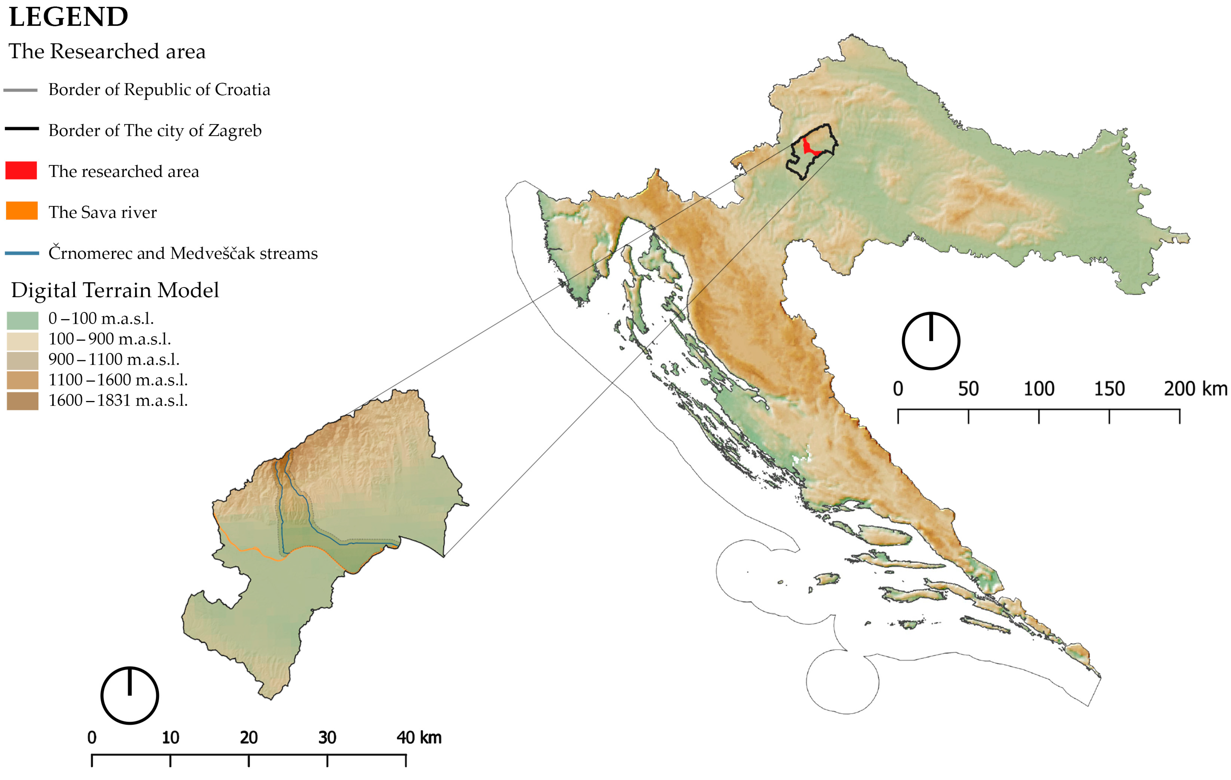
Figure 1. Location of researched area in the regional and national contexts.
Sustainability 15 09959 g001
Figure 2. Location of Črnomerec and Medveščak streams (Source: Geoportal of the State Geodetic Administration of the Republic of Croatia, 2022).
Sustainability 15 09959 g002
Figure 3. Flowchart of the methodology.
Sustainability 15 09959 g003
Figure 4. Pedological characteristics (Source: Geoportal of the State Geodetic Administration of the Republic of Croatia, 2022).
Sustainability 15 09959 g004
Figure 5. Land cover (Source: Geoportal of the State Geodetic Administration of the Republic of Croatia, 2022; spatial data: Bioportal).
Sustainability 15 09959 g005
Figure 6. Protected areas (Source: Geoportal of the State Geodetic Administration of the Republic of Croatia, 2022; spatial data: Bioportal).
Sustainability 15 09959 g006
Figure 7. Monthly amount of precipitation (mm) for the station Zagreb–Maksimir for the year 2021 (Source: Croatian Meteorological and Hydrological Service, 2022).
Sustainability 15 09959 g007
Figure 8. Maximum measured amounts of precipitation (mm) per day and average maximum amounts of precipitation for the station Zagreb–Maksimir/Grič for the period from 2012 to 2021 (Source: Croatian Meteorological and Hydrological Service, 2022).
Sustainability 15 09959 g008
Figure 9. Maximum daily measured amounts of precipitation (mm) per month for the station Zagreb–Maksimir for the period from 1950 to 2020 (Source: Croatian Meteorological and Hydrological Service, 2022).
Sustainability 15 09959 g009
Figure 10. Monthly temperature (°C) for the station Zagreb–Maksimir for the year 2021 (Source: Croatian Meteorological and Hydrological Service, 2022).
Sustainability 15 09959 g010
Figure 11. Overview of absolute maximum temperatures (°C) for the station Zagreb–Maksimir for the period from 1950 to 2021 by month (Source: Croatian Meteorological and Hydrological Service, 2022).
Sustainability 15 09959 g011
Figure 12. The highest and lowest measured water levels (cm) per month at the measuring station Fraterščica 1–Črnomerec for the period from 1955 to 2020 (Source: Legal entity for water management, 2022).
Sustainability 15 09959 g012
Figure 13. The highest and lowest measured water levels (cm) per month at the measuring station Mikulići–Črnomerec for the period from 1992 to 2020 (Source: Legal entity for water management, 2022).
Sustainability 15 09959 g013
Figure 14. The highest and lowest measured water levels (cm) per month at the measuring station Mihaljevac 1–Medveščak for the period from 1992 to 2020 (Source: Legal entity for water management, 2022).
Sustainability 15 09959 g014
Figure 15. Flood risk area (Source: Geoportal of the State Geodetic Administration of the Republic of Croatia, 2022; Legal entity for water management, 2022).
Sustainability 15 09959 g015
Figure 16. Areas of groundwater and sanitary protection (Source: Geoportal of the State Geodetic Administration of the Republic of Croatia, 2022; Legal entity for water management, 2022).
Sustainability 15 09959 g016
Figure 17. Maps of (a) urban and rural landscape; (b) sewage system and connection points with streams; (c) settlements and traffic; (d) cycle paths and traffic (Source: Geoportal of the State Geodetic Administration of the Republic of Croatia, 2022; spatial data: Bioportal; General urbanistic plan of the city of Zagreb).
Sustainability 15 09959 g017
Figure 18. Landscape ecological analysis according to Forman and Godron (Source: Geoportal of the State Geodetic Administration of the Republic of Croatia, 2022).
Sustainability 15 09959 g018
Figure 19. Analysis of immovable cultural properties (Source: Geoportal of the State Geodetic Administration of the Republic of Croatia, 2022; Geoportal of Cultural Property of the Republic of Croatia, 2022).
Sustainability 15 09959 g019
Figure 20. Areas with potential for NBS implementation (Source: Geoportal of the State Geodetic Administration of the Republic of Croatia, 2022).
Sustainability 15 09959 g020
Figure 21. Conceptual solutions (Source: Geoportal of the State Geodetic Administration of the Republic of Croatia, 2022).
Sustainability 15 09959 g021
Figure 22. Lower area (subzone) of zone IV of the Črnomerec stream: (a) elevation analysis; (b) surface permeability; (c) the relationship between public (city, state) and private property (in this case, the subzone is city property) (Source: Geoportal of the State Geodetic Administration of the Republic of Croatia, 2022).
Sustainability 15 09959 g022
Figure 23. Conceptual solutions for the subzone of Črnomerec stream.
Sustainability 15 09959 g023
Figure 24. Upper area (subzone) of zone I of the Medveščak stream: (a) elevation analysis; (b) surface permeability; (c) the relationship between public (city, state) and private property (in this case, the subzone is city property) (Source: Geoportal of the State Geodetic Administration of the Republic of Croatia, 2022).
Sustainability 15 09959 g024
Figure 25. Conceptual solutions for the subzone of Medveščak stream.
Sustainability 15 09959 g025
Table 1. Spatial data and sources used.
Spatial DataSources
Daily amount of precipitation (mm) for the station Zagreb–Maksimir/Grič for the period from 1950 to 2022; daily temperatures (°C) for the station Zagreb–Maksimir for the period from 1950 to 2022State Hydrometeorological Institute
Hazard and flood risk maps; daily measured water levels (cm) at the measuring station Fraterščica 1–Črnomerec for the period from 1955 to 2020; daily measured water levels (cm) at the measuring station Mikulići–Črnomerec for the period from 1992 to 2020; daily measured water levels (cm) at the measuring station Mihaljevac 1–Medveščak for the period from 1992 to 2020; register of protected areas—polygons of special water protectionLegal entity for water management
Hydrogeological map 1: 300,000 (WMS); digital elevation model 20 mCroatian Geological Survey
Mapped locations for endangered flora and faunaThe Ministry of Economy and Sustainable Development of the Republic of Croatia
WFS: Digital orthophoto; Croatian base map; topographic mapsWMS: Transport corridors; cycling infrastructure; squares; categorisation of watercourses; land use polygons; channelised sections of watercourses; points of connection of watercourses to the municipal sewage network; municipal sewage network; water supply polygon; infrastructural spatial boundaries; greenery registryGeoportal of the State Geodetic Administration of the Republic of Croatia
Spatial Plan of the City of ZagrebSpatial Planning Information System
General urban plan of the city of Zagreb; digital cadastral plan; greenery cadastre; topographical basis; digital elevation model; strategic land use planSpatial Data Infrastructure of the City of Zagreb
WFS: Sava River polygon; illegal dumpsites in speleological objects; registry of speleological objects; watercourse lines; Natura 2000 areas; water protection zone; habitat polygonsBioportal
The pedological mapVesna Vukadinović
Recorded measurement of the Črnomerec stream at the Srednjaci location for the year 2020University of Zagreb
Faculty of Agriculture
Table 2. Recorded measurements of the Črnomerec stream at the Srednjaci location for the year 2020 [45].
LocationČrnomerec Stream, SrednjaciLimit Value
Code51168
MediumSurface Water
MicrolocationMiddle of the Water Course
Date27 February 202026 May 202030 July 202029 October 202024 November 202021 December 2020
Electrical conductivity at 25 °C (µS/cm)501484546566567597-
pH value8.58.57.88.38.28.26.5–9.0
Water temperature (°C)11.418.829.615.78.47.330
Ammonium (mgN/L)0.0330.04020.180.0480.0280.115
Nitrates (mgN/L)1.111.130.621.31.31.62
Nitrites (mgN/L)0.01850.04940.0440.0310.0120.0341
Orthophosphates dissolved (mgP/L)0.01610.05720.08470.0430.030.0641
Total nitrogen (mgN/L)1.71.561.651.71.72.115
Total phosphorus (mgP/L)0.02380.110.1330.06860.05170.06641.5
Calcium (mg/L)73.375.386908989-
Potassium (mg/L)2.563.9232.92.32.312
Chlorides (mg/L)34.638.327293335-
Magnesium (mg/L)14.114.716141515-
Sodium (mg/L)20.524.92620202115
Sulphates (mg/L)26.724.817262627250
Table 3. NBS proposal for the subzones of the Medveščak and Črnomerec streams.
NBS ElementsMedveščak Stream ZonesČrnomerec Stream Zones
I.II.III.IV.I.II.III.IV.
Pond X
Plant devices for underground retention X X
Biodetention XX
Biofiltration X X
Bioretention X X
Flower meadowsX X
Enhancing biodiversity XX X
Wooden dams X
Allée XXX XXX
Pocket gardens XX
Extensive green roofs X
Phytoremediation XXX XXX
City parkX X
Shrub colonnade XXX XXX
Insect hotelX X X
SwalesX XX X
Infiltration tanksX X
Intensive green roofs XX XX
Lake X
Rain garden X X
Composting and green manure X X
Greenway X
Mulching X X
Habitat restorationX XX
Forest restorationXX XX
Preservation of trees XX
Habitat conservationXX XX X
Daylighting streams XXX
Green railroadsXXXX
Improving soil quality and structure X X
Semi-intensive green roofs XX
Green–grey infrastructure XXXXX
Occasionally flooded zonesXX X X
Underflow weirs X X
Stream mitigation XXX
Permeable pipe/channelX X
Permeable paving XX XX
Reclaiming the coastline X X
Retention basin X
Fishpond X X XX
Solitary trees X X X
Rainwater tank X X
Infiltration system X X
Grass swales X X
Grass grates XX XX
Lawn X
Artificial wetland X X
Artificial meanderingX X
Soak away pit X X
Urban forestX X
Urban orchardsX X
Urban gardens X X
Vegetation systems for erosion controlXX XX
Vertical greening X X
Wet meadowsX X X
Water playground X X
Stream bed re-naturalisation XXX XX
Green buffer zone XX
Green corridor XX XX
Green squares X
Table 4. NBS proposal for the Črnomerec stream subzone.
Function Protection of the Existing HabitatHabitat RevitalisationHabitat CreationPromoting BiodiversityWater DetentionWater RetentionSlowing Down Water FlowWater PurificationFormation of Educational and Recreational ZonesImproving MicroclimateAesthetic and Economic ValueImproving Air QualityReducing Flood RisksReducing Drought Risks
NBS Elements
Allée X XXX X
Phytoremediation X X X X X X X
City park XX XXXX
Shrub colonnade XX XXX
Insect hotelX X X
SwalesX XX X X XX
Rain garden XX XXX XX XX
Semi-intensive green roofs XX X XXX X
Occasionally flooded zones XX X XX
Fishpond XXX XXX X
Solitary trees X X XXX X
Rainwater tank XX X X
Artificial wetland XXX XXXX X X
Wet meadowsX X XX X XX
Vegetation for erosion controlXX X XXXXXXXX
Water playground X X XX X
Permeable paving X X X
Table 5. NBS proposal for the Medveščak stream subzone.
FunctionProtection of the Existing HabitatHabitat RevitalisationHabitat CreationPromoting BiodiversityWater DetentionWater RetentionSlowing Down Water FlowWater PurificationFormation of Educational and Recreational ZonesImproving MicroclimateAesthetic and Economic ValueImproving Air QualityReducing Flood RisksReducing Drought Risks
NBS Elements
Flower meadows X X X XX
Allée X XXX X
Phytoremediation X X X X X X X
Shrub colonnade XX XXX
SwalesX XX X X XX
Rain garden XX XXX XX XX
Underflow weirsX X X
Urban forest X X XXXXX
Vegetation for erosion controlXX X XXXXXXXX
Wet meadowsX X XX X XX
Water playground X X XX X
Permeable paving X X X
Disclaimer/Publisher’s Note: The statements, opinions and data contained in all publications are solely those of the individual author(s) and contributor(s) and not of MDPI and/or the editor(s). MDPI and/or the editor(s) disclaim responsibility for any injury to people or property resulting from any ideas, methods, instructions or products referred to in the content.