
Biodiversity as an Outstanding Universal Value for Integrated Management of Natural and Cultural Heritage
 ,
,
Abstract
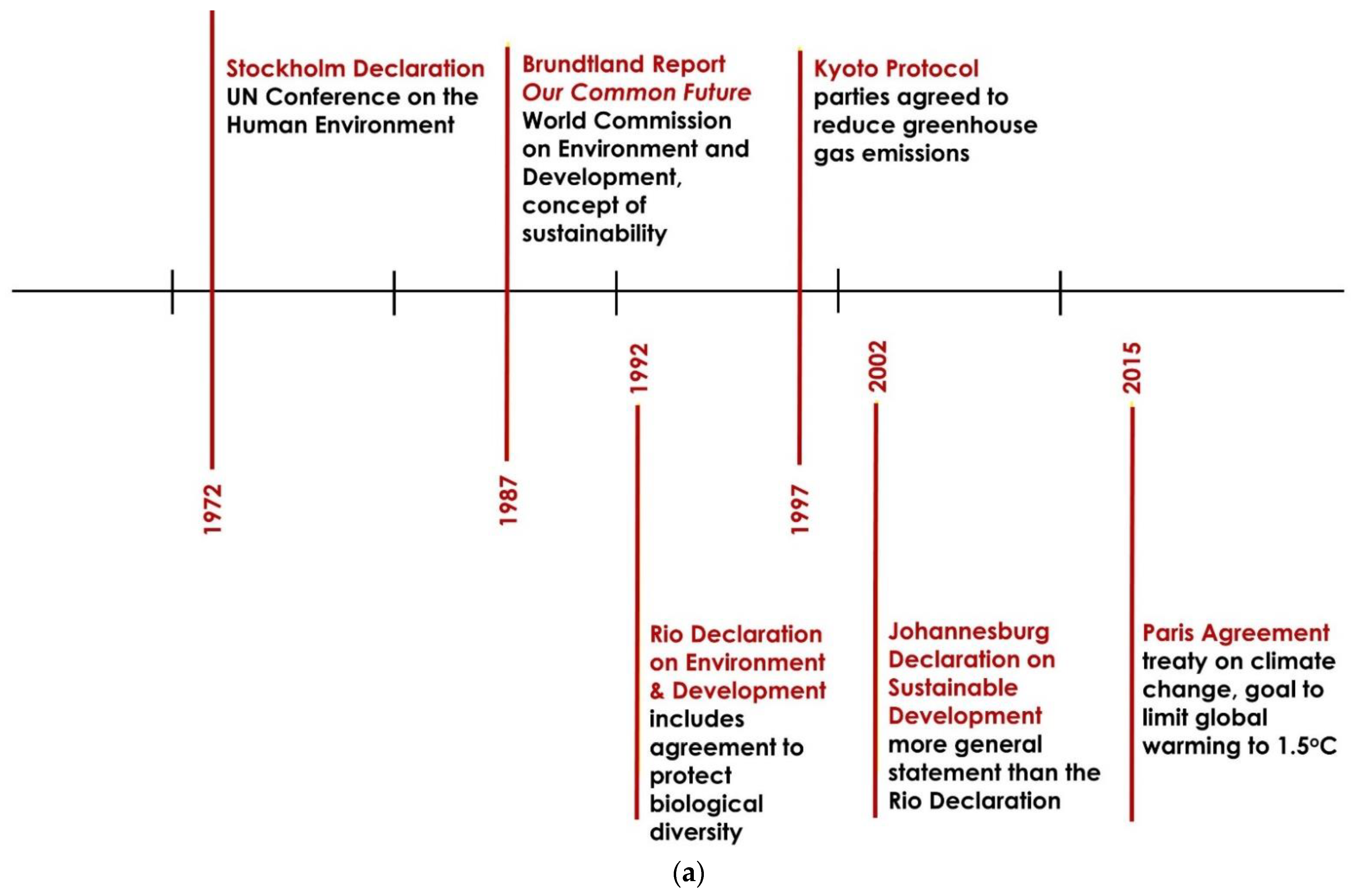
:1. Introduction
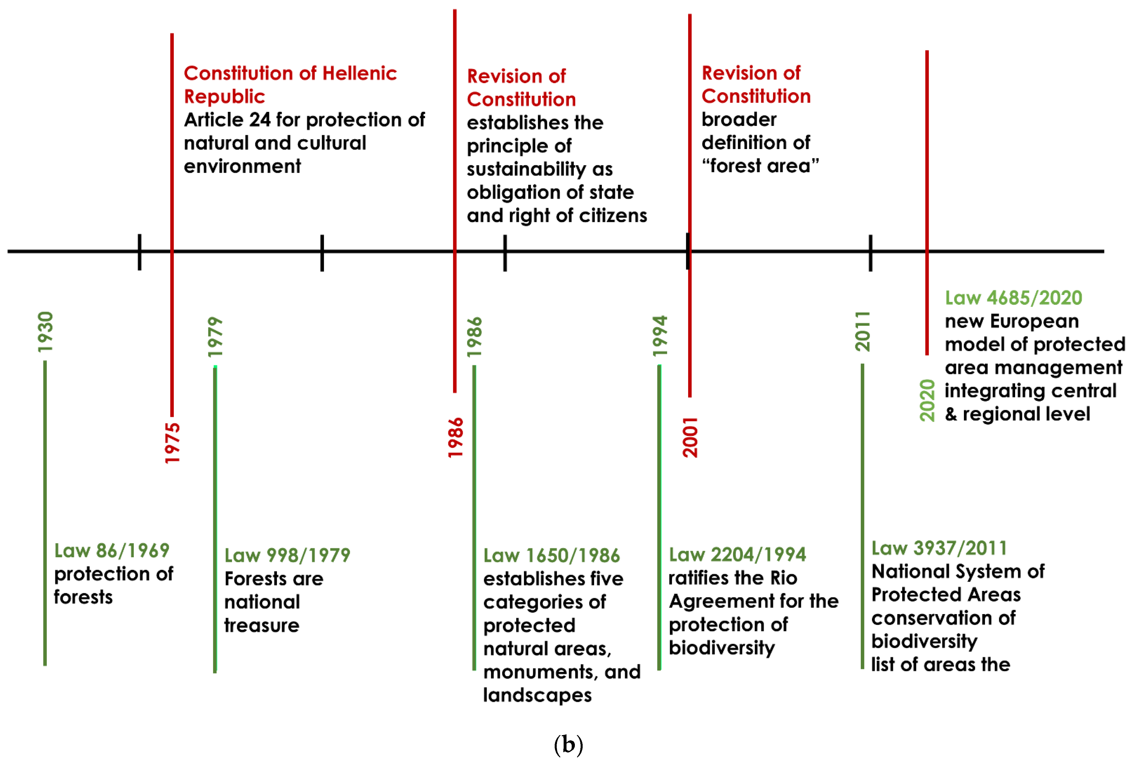
1.1. Legislation for the Protection of Cultural Heritage in Greece
1.2. Environmental Legislation in Greece
- The establishment of a National System of Protected Areas;
- The conservation of Greek biodiversity species through the employment of monitoring and protection tools, special provisions for the protection and conservation of endemic biodiversity, but also special regulations for invasive alien species;
- The conservation of natural ecosystems and the prevention of their degradation;
- The scientific research, social information, and participation;
- (a) It defines also the national list of areas included in the Natura 2000 Network and (b) updates and identifies the framework for the integrated protection of the Greek biological wealth and the fulfilment of its community obligations in relation to the Natura 2000 Network [48].
- As a dynamic law field that has evolved into one of the most voluminous and ever-evolving specialised legal fields.
- All provisions related to the protection of the environment are the political and legal response to scientific remarks and observations. The legal framework has to be (re) adapted to respond more effectively to environmental challenges and scientific solutions to environmental degradation.
- In addition to strict legal commitments, political decisions and resolutions of international organisations set rules that cultivate a sense of responsibility and ultimately an obligation that states respect.
- Many stakeholders in all phases of its constantly evolving cycle, from its creation to implementation and enforcement, compliance, monitoring, and revision, are involved, including states, international organizations, non-governmental organizations (NGOs), businesses, academia and scientists, and internal administration of each state, as well as local government.
- The application of environmental law affects the daily life of the citizen at the local level and requires a change in the lifestyle of every citizen of the planet.
2. Methodology Approach
2.1. Materials and Methods
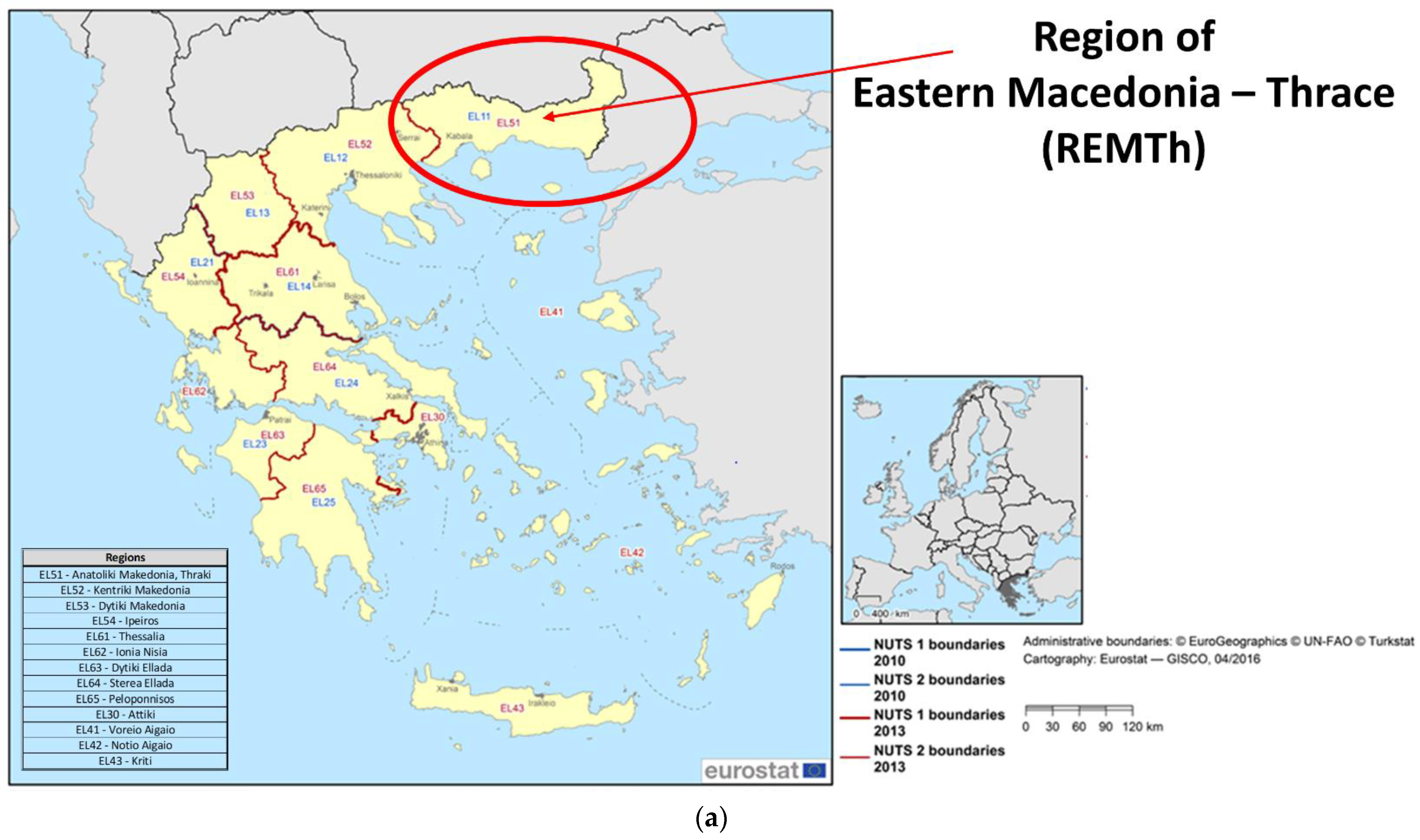
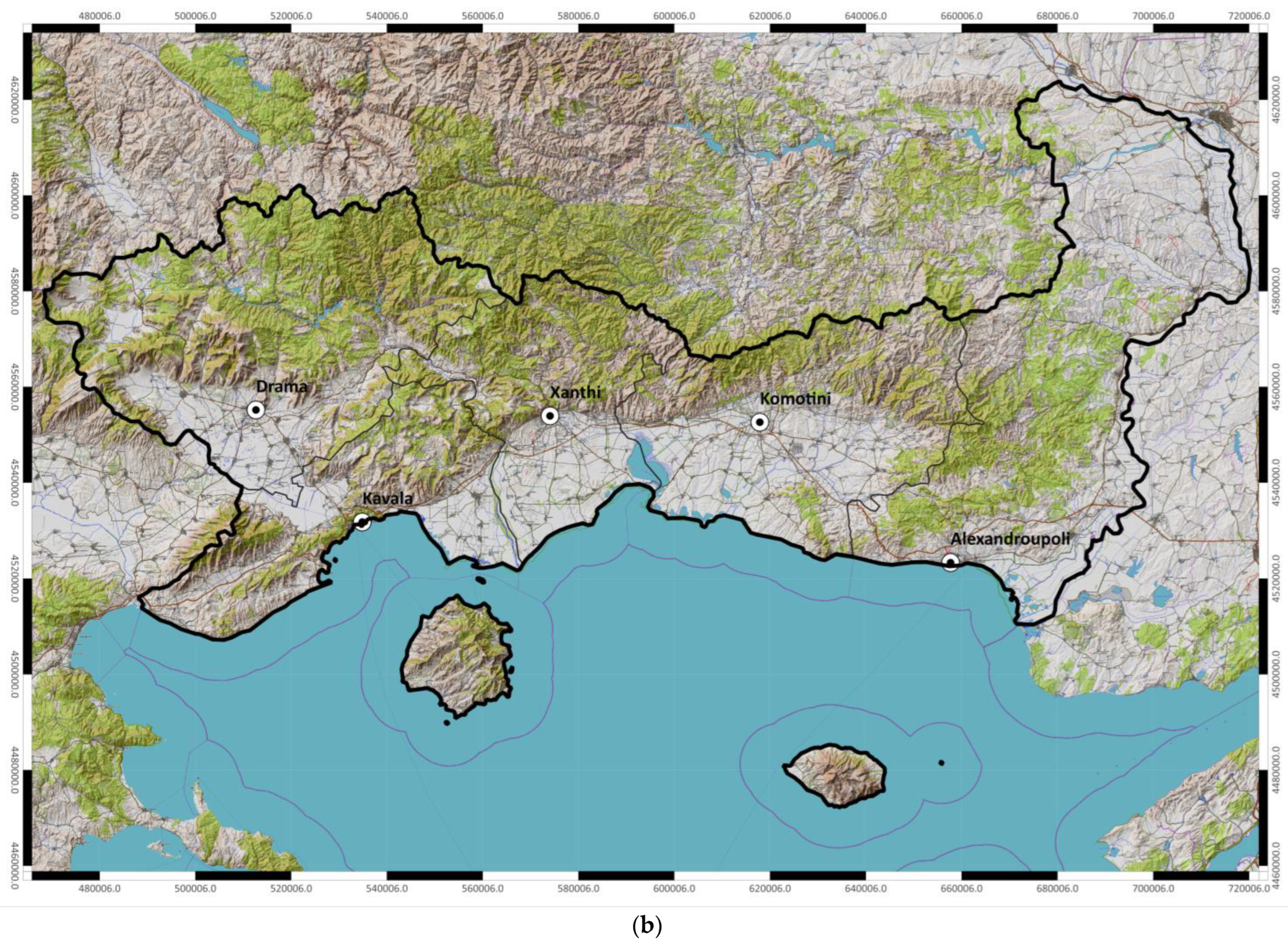
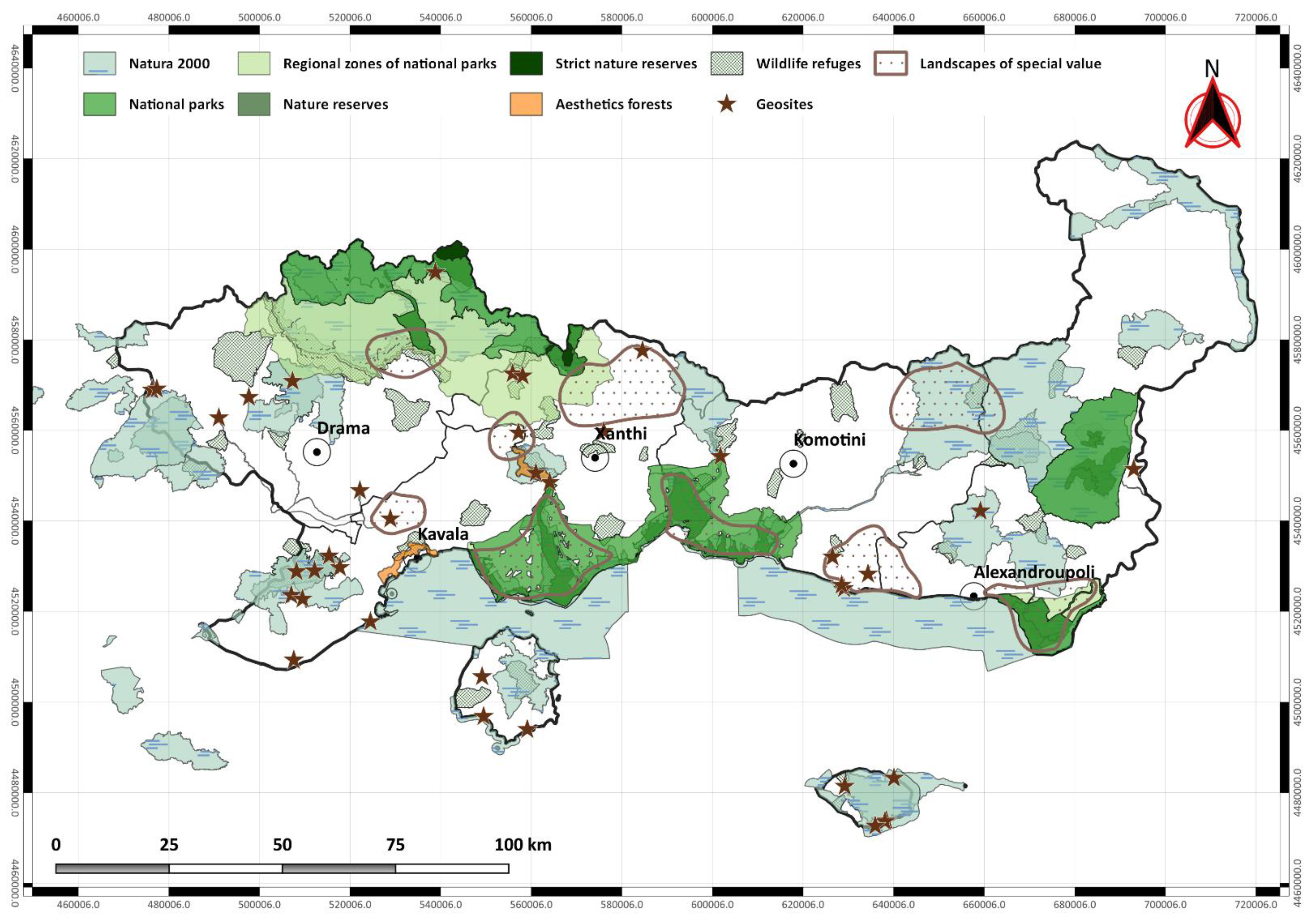
2.2. Study Area
- Mid-Mediterranean formation of Aria (Quercion ilicis) Balkan and Eastern Mediterranean type;
- Sub-Mediterranean formation (Ostryo-Carpinion);
- Variations of thermophilic subcontinental deciduous oaks;
- Mountain-Mediterranean formation of Oak-hybrid Spruce;
- Mountain-Mediterranean pine forest, Erythrelatis;
- Azonian riparian delta formations of estuaries.
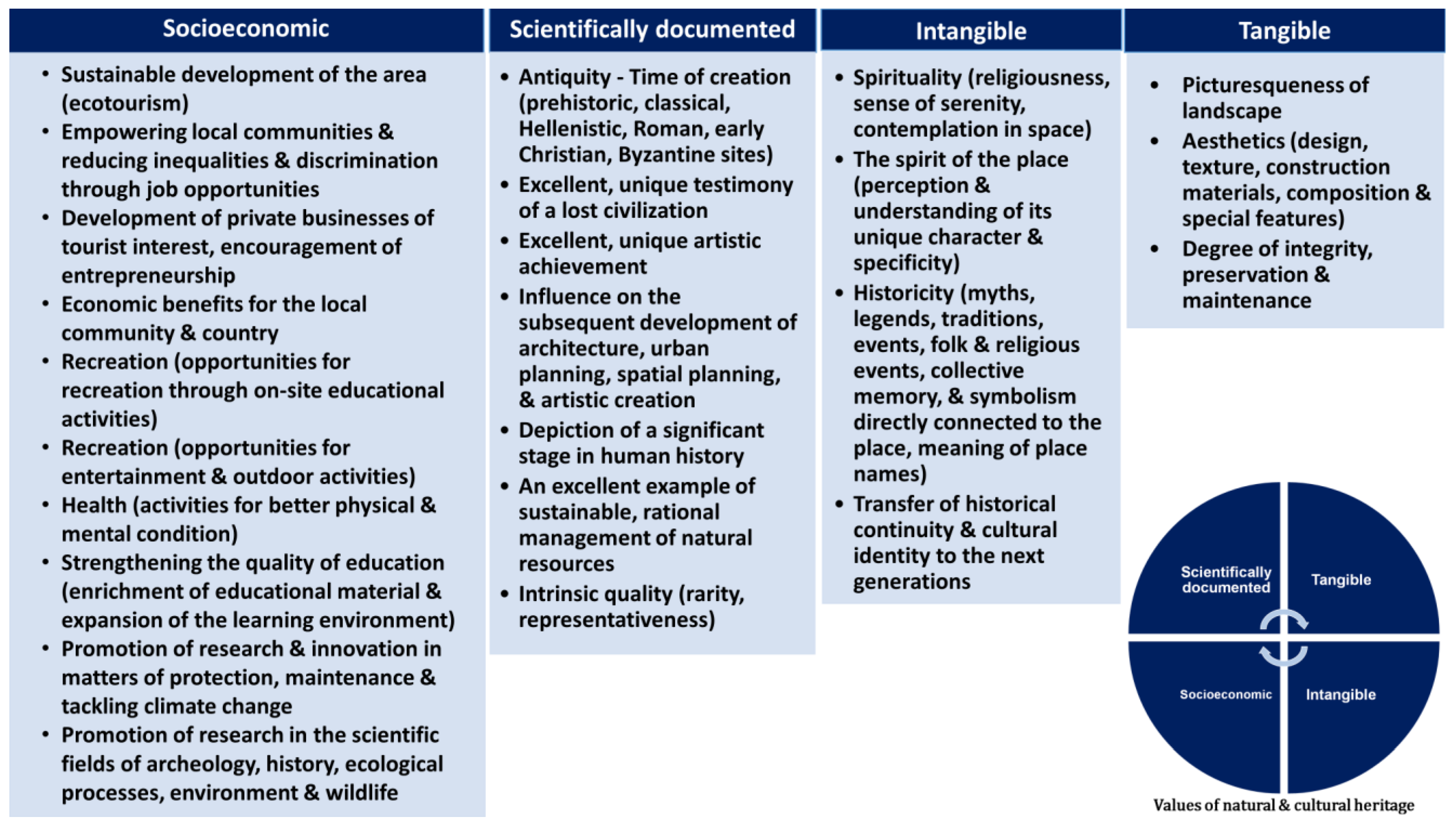
3. Analysis and Results
Findings
- High-visibility, the possibility of visitation: a monument/site that has been fully excavated is regularly cleaned and conserved so that the antiquities remain visible, can be located via signage, information boards, digital tools, etc., is accessible easily and safely via maintained and safe roads, has infrastructure for the public, is open at specific times in case it is enclosed, which on the one hand are respected, and on the other hand are easy to know.
- Partial visibility, potential visitation: a monument/site that, although it has not been excavated and displayed, is preserved to a great extent, resulting in someone with special means and personal responsibility being able to approach it with relative safety and see a part of it.
- Low-visibility, impossible/restricted/conditional access: archaeological sites where research has stopped, or is progressing, and are therefore impossible to be displayed and remain restricted for the safety of the antiquities first and the public second. They can only be visited by experts and by appointment.
- Invisibility, impossible to visit: Archaeological sites that have yielded only mobile findings in surface research or during excavation of any construction, tombs usually, and were removed. These positions are only of topographical interest, mainly for expert groups, scientists, teachers, students, and pupils. To expand their visitation, they should be combined with an exhibition of their antiquities in an archaeological collection and a relevant information sign in the place. Usually, after visiting the local museum and admiring the exhibitions, the visitors are curious and can look for the place. This, of course, is impossible in the case of movable antiquities that remain in place. In addition, the financial and environmental cost of providing accessible facilities, fencing, opening roads, signage, etc., should be balanced and co-assessed with the expected result. Finally, what is the value/importance of the general public’s visit to a location that offers nothing to see?
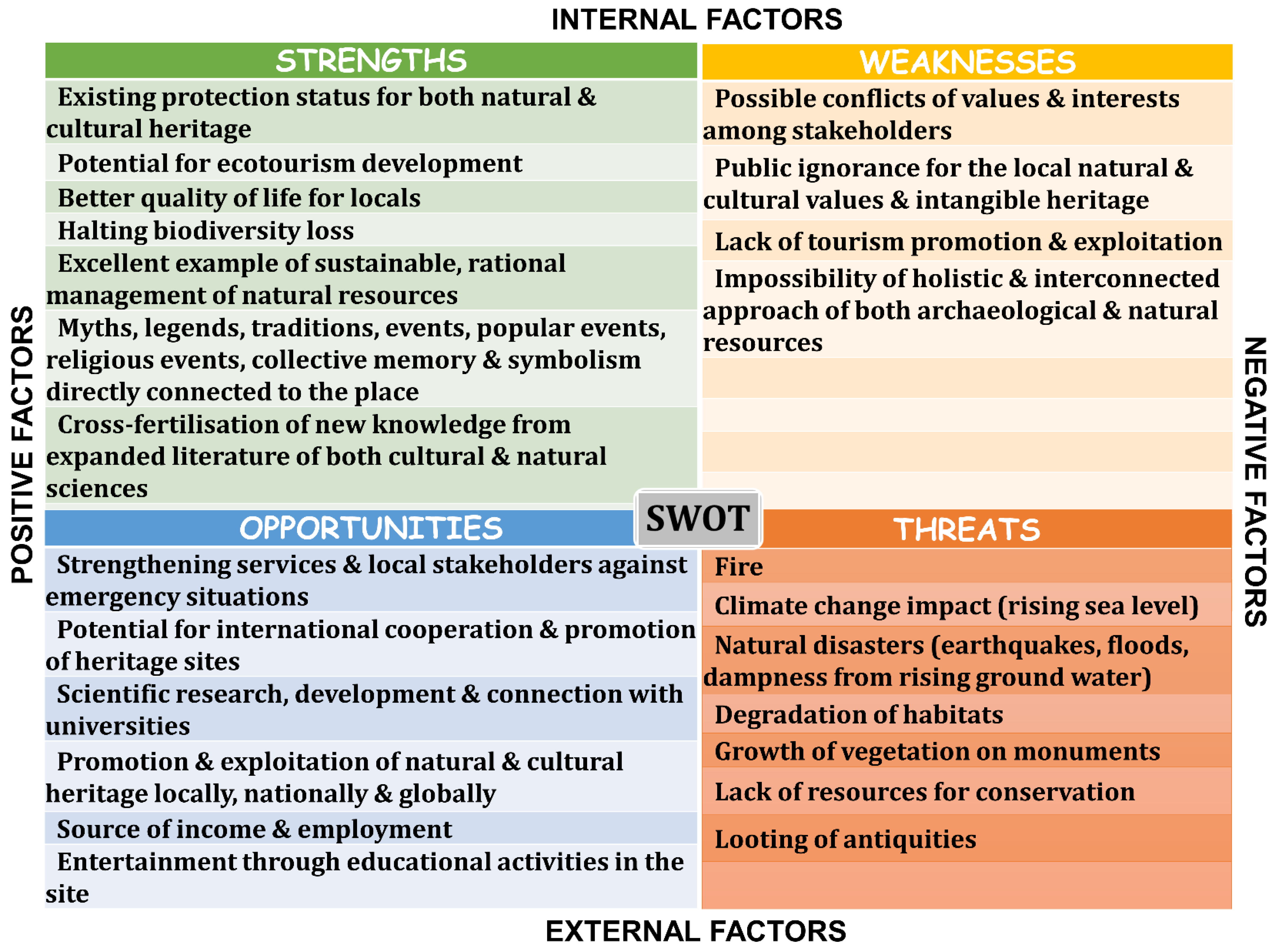
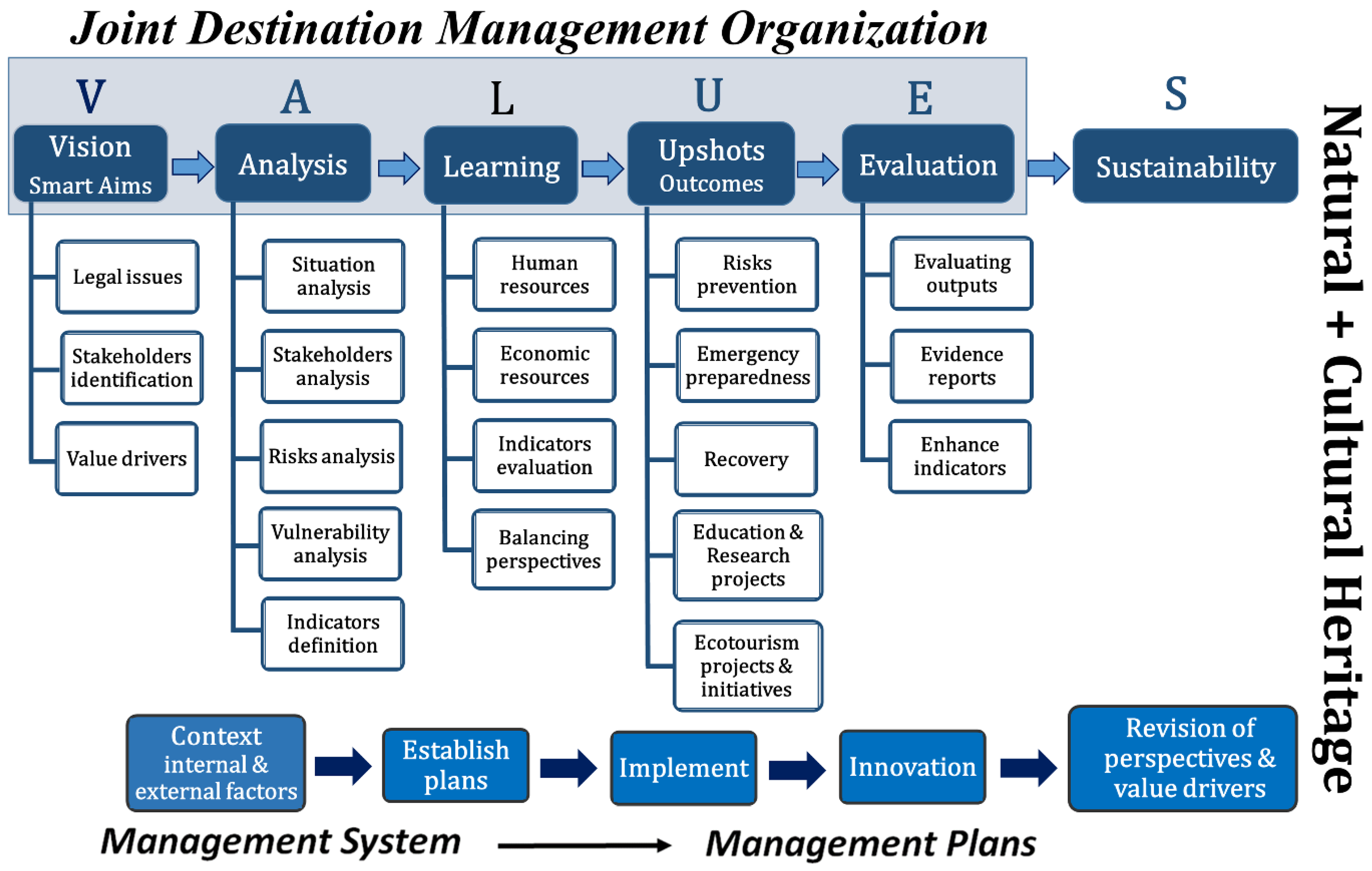
4. Discussion
5. Conclusions
Author Contributions
Funding
Institutional Review Board Statement
Informed Consent Statement
Data Availability Statement
Acknowledgments
Conflicts of Interest
Appendix A
Appendix A.1. The Natural Heritage
Appendix A.2. The Cultural Heritage
References
- The United Nations Educational, Scientific and Cultural Organization. Operational Guidelines for the Implementation of the World Heritage Convention; UNESCO: Paris, France, 2021. [Google Scholar]
- Cleere, H. The concept of ‘Outstanding Universal Value’ in the world heritage convention. Conserv. Manag. Archaeol. Sites 1996, 1, 227–233. [Google Scholar] [CrossRef]
- Blake, J. On defining the cultural heritage. Int. Comp. Law Q. 2008, 49, 61–85. [Google Scholar] [CrossRef]
- The United Nations Educational, Scientific and Cultural Organization. Preparing World Heritage Nominations; UNESCO: Paris, France, 2011. [Google Scholar]
- Vlami, V.; Kokkoris, I.P.; Zogaris, S.; Cartalis, C.; Kehayias, G.; Dimopoulos, P. Cultural landscapes and attributes of “culturalness” in protected areas: An exploratory assessment in Greece. Sci. Total Environ. 2017, 595, 229–243. [Google Scholar] [CrossRef] [PubMed]
- The United Nations Educational, Scientific and Cultural Organization. Convention Concerning the Protection of the World Cultural and Natural Heritage. Available online: https://whc.unesco.org/archive/convention-en.pdf (accessed on 14 April 2023).
- Constitution of Greece (1975)-FEK a 111-09-6-1975. Available online: https://www.e-nomothesia.gr/syntagma/suntagma-ellados-1975.html (accessed on 14 April 2023).
- Koch, E.; Gillespie, J. Separating natural and cultural heritage: An outdated approach? Aust. Geogr. 2022, 53, 167–181. [Google Scholar] [CrossRef]
- International Council on Monuments and Sites. The Venice Charter. Available online: https://www.icomos.org/images/DOCUMENTS/Charters/Venice_Charter_EN_2023.pdf (accessed on 14 April 2023).
- Giannakourou, G. The Environmental Constitution and the Revision Project. Available online: https://nomosphysis.org.gr/18128/to-perivallontiko-syntagma-kai-to-anatheoritiko-egxeirima/ (accessed on 14 April 2023).
- Law 1650/1986-FEK α-160/16-10-1986. Available online: https://www.e-nomothesia.gr/kat-periballon/n-1650-1986.html (accessed on 14 April 2023).
- L/3028. For the protection of antiquities and cultural heritage in general. In Government Gazette; 153/A/28-6-2002; Greek Government: Athens, Greece, 2002.
- Katsos, C. Law + Nature, Cultural Environment, Cultural Heritage and the New Law 3028/2002: First Thoughts and Conceptual Approaches (November 2003). Available online: https://nomosphysis.org.gr/7053/politistiko-periballon-politistiki-klironomia-kai-o-neos-nomos-30282002-protes-skepseis-kai-ennoiologikes-proseggiseis-noembrios-2003/ (accessed on 14 April 2023).
- Directorate-General for Environment (European Commission). Linking Natura 2000 and Cultural Heritage: Case Studies; Publications Office of the European Union: Luxembourg, 2017. [Google Scholar]
- Directorate-General for Environment (European Commission). Europe’s Cultural and Natural Heritage in Natura 2000; Publications Office of the European Union: Luxembourg, 2018. [Google Scholar]
- Directorate-General for Environment (European Commission); Sundseth, K. Natural and Cultural Heritage in Europe: Working together within the Natura 2000 Network; Publications Office of the European Union: Luxembourg, 2019. [Google Scholar]
- Bonazza, A.; Bonora, N.; Duke, B.; Spizzichino, D.; Recchia, A.P.; Taramelli, A. Copernicus in support of monitoring, protection, and management of cultural and natural heritage. Sustainability 2022, 14, 2501. [Google Scholar] [CrossRef]
- Cassar, M.; Pender, R. The impact of climate change on cultural heritage: Evidence and response. In ICOM Committee for Conservation: 14th Triennial Meeting; Hague, P., Ed.; James & James: Springdale, AR, USA, 2005; Volume 2, pp. 610–616. [Google Scholar]
- Lowenthal, D. Natural and cultural heritage. Int. J. Herit. Stud. 2005, 11, 81–92. [Google Scholar] [CrossRef]
- Murzyn-Kupisz, M. Sustainable approaches to natural environment and cultural heritage. Two sides of the same coin? Econ. Environ. Stud. 2010, 10, 379–397. [Google Scholar]
- Boer, B. The environment and cultural heritage. In The Oxford Handbook of International Cultural Heritage Law; Francioni, F., Vrdoljak, A.F., Eds.; Oxford University Press: Oxford, UK, 2020; pp. 318–346. [Google Scholar]
- Powell, R.B.; Ramshaw, G.P.; Ogletree, S.S.; Krafte, K.E. Can heritage resources highlight changes to the natural environment caused by climate change? Evidence from the Antarctic tourism experience. J. Herit. Tour. 2016, 11, 71–87. [Google Scholar] [CrossRef]
- Breen, C.; El Safadi, C.; Huigens, H.; Tews, S.; Westley, K.; Andreou, G.; Vazquez, R.O.; Nikolaus, J.; Blue, L. Integrating cultural and natural heritage approaches to marine protected areas in the Mena region. Mar. Policy 2021, 132, 104676. [Google Scholar] [CrossRef]
- Ghazali, S. Safeguarding natural and cultural heritage: The experiences of Teluk Bahang fishing communities, Penang, Malaysia. Malays. J. Environ. Manag. 2011, 12, 47–58. [Google Scholar]
- Iranzo-García, E.; Kortekaas, K.H.; López, E.R. Inland salinas in Spain: Classification, characterisation, and reflections on unique cultural landscapes and geoheritage. Geoheritage 2021, 13, 24. [Google Scholar] [CrossRef]
- D’Ascanio, R.; Barbieri, L.; De Pasquale, G.; Filpa, A.; Palazzo, A.L. Landscape works. Balancing nature and culture in the Pantelleria national park. Sustainability 2021, 13, 13371. [Google Scholar] [CrossRef]
- Kubalíková, L.; Zapletalová, D. Geo-cultural aspects of building stone extracted within Brno city (Czech Republic): A bridge between natural and cultural heritage. Geoheritage 2021, 13, 78. [Google Scholar] [CrossRef]
- Margottini, C.; Spizzichino, D. Historical accesses to Unesco cultural heritages: Engineering geology for the sustainable conservation of Petra Siq. Innov. Infrastruct. Solut. 2017, 2, 25. [Google Scholar] [CrossRef]
- Brabec, E.; Chilton, E.S. Toward an ecology of cultural heritage. Change Over Time 2015, 5, 266–285. [Google Scholar] [CrossRef]
- Kimeev, V.M. Ecomuseums in Siberia as centers for ethnic and cultural heritage preservation in the natural environment. Archaeol. Ethnol. Anthropol. Eurasia 2008, 35, 119–128. [Google Scholar] [CrossRef]
- Liburd, J.; Blichfeldt, B.; Duedahl, E. Transcending the nature/culture dichotomy: Cultivated and cultured world heritage nature. Marit. Stud. 2021, 20, 279–291. [Google Scholar] [CrossRef]
- Mustafa, B.; Hajdari, A.; Mustafa, V.; Pulaj, B. Natural heritage in the republic of Kosovo: Looking for potential Unesco sites. Landsc. Online 2018, 63, 1–16. [Google Scholar] [CrossRef]
- Dollani, A.; Lerario, A.; Maiellaro, N. Sustaining cultural and natural heritage in Albania. Sustainability 2016, 8, 792. [Google Scholar] [CrossRef]
- Lazarević, S.; Arbutina, D.; Popović, S. The role of the archeological heritage sites in the process of urban regeneration of Unesco’s cities—Boka Bay case study. Sustainability 2022, 14, 1566. [Google Scholar] [CrossRef]
- Zhang, R.; Wang, J.; Brown, S. ‘The charm of a thousand years’: Exploring tourists’ perspectives of the ‘culture-nature value’ of the humble administrator’s garden, Suzhou, China. Landsc. Res. 2021, 46, 1071–1088. [Google Scholar] [CrossRef]
- Marafa, L. Integrating natural and cultural heritage: The advantage of feng shui landscape resources. Int. J. Herit. Stud. 2003, 9, 307–323. [Google Scholar] [CrossRef]
- Khalaf, R.W. Integrity: Enabling a future-oriented approach to cultural heritage. Hist. Environ. Policy Pract. 2022, 13, 5–27. [Google Scholar] [CrossRef]
- Khalaf, R.W. The implementation of the Unesco world heritage convention: Continuity and compatibility as qualifying conditions of integrity. Heritage 2020, 3, 384–401. [Google Scholar] [CrossRef]
- Stovel, H. Effective use of authenticity and integrity as world heritage qualifying conditions. City Time 2007, 2, 21–36. [Google Scholar]
- Hølleland, H.; Skrede, J.; Holmgaard, S.B. Cultural heritage and ecosystem services: A literature review. Conserv. Manag. Archaeol. Sites 2017, 19, 210–237. [Google Scholar] [CrossRef]
- Petrakos, V. Essay on Archaeological Legislation/Δοκίμιο για την αρχαιολογική νομοθεσία; Archaeological Resources and Expropriations Fund: Athens, Greece, 1982. [Google Scholar]
- L/4858. “Sanction of a code of legislation for the protection of antiquities and cultural heritage in general”, which just replaced Law 3028/2002 “for the protection of antiquities and cultural heritage in general” (a’ 153), article 1, 2. In Government Gazette; Greek Government: Athens, Greece, 2021.
- Akrivopoulou, S.; Dalakoura, N. 100 years of archaeology in Thrace 1920–2020/100 χρόνια αρχαιολογίας στη Θράκη, 1920–2020. Thrakika 2020, 21–22, 34–35. [Google Scholar]
- P.D. Presidential Decree 171/2014-FEK 171/α/2014 and P.D. 4/2018-FEK 7/α/2018. 2014/2018. Available online: https://www.kodiko.gr/nomologia/download_fek?f=fek/2018/a/fek_a_7_2018.pdf&t=ff00abe6e4e0db934d8ec98e5e4959f2 (accessed on 22 December 2022).
- Greek Government. 171A. Presidential Decree: Part One-Mission-Structure of Services-Competences Chapter C—Service Units Under the Secretary General of the Ministry of Culture and Sports Article 18—Ephorates of Antiquities Sports; Greek Government: Athens, Greece, 2014. [Google Scholar]
- World Wide Fund for Nature. Legal Guide for the Environment; World Wide Fund for Nature: Athens, Greece, 2009. [Google Scholar]
- Papageorgiou, K.; Kassioumis, K. The national park policy context in Greece: Park users’ perspectives of issues in park administration. J. Nat. Conserv. 2005, 13, 231–246. [Google Scholar] [CrossRef]
- EKBY. Site for Nature and Biodiversity: Law 3937/2011 on “Biodiversity Conservation and Other Regulations”. Available online: Http://www.Biodiversity-info.Gr/index.Php/el/legislation/greek-biodiversity-law. (accessed on 3 June 2022).
- Database: Law 1650/1986. Available online: https://www.Kodiko.Gr/nomothesia/document/269310/nomos-1650-1986. (accessed on 28 May 2022).
- QGIS. Development Team Qgis Geographic Information System, Open-Source Geospatial Foundation Project. Available online: https://qgis.org/en/site/ (accessed on 18 August 2022).
- UNwebTV. Pre-Climate Action Summit Event “Cultural Heritage Partnership to Enable Ambitious Climate Action”, Minister of Culture and Sports Lina Mendoni, Video: 2:55–10:45. New York, 21 September 2019. Available online: https://media.un.org/en/asset/k1n/k1ng14hnjn (accessed on 28 May 2022).
- Filotis. Database for Greek Nature. Available online: https://filotis.Itia.Ntua.Gr/biotopes/?Category=1&geo_code=1%2c1%2c0 (accessed on 28 May 2022).
- Kougioumoutzis, K.; Kokkoris, I.P.; Panitsa, M.; Kallimanis, A.; Strid, A.; Dimopoulos, P. Plant endemism centres and biodiversity hotspots in Greece. Biology 2021, 10, 72. [Google Scholar] [CrossRef]
- Lever. Development Consultants. Regional Development Programme. Region of East Macedonia-Thrace 2021–2025. Strategic Environmental Assessment. Region of East Macedonia-Thrace: General Administration of Environmental and Infrastructure Development Planning, Directorate of Development Planning. 2021. Available online: https://www.pamth.gov.gr/index.php/el/enimerosi/diafaneia/deltia-typou-anakoinoseis/perodopis/item/download/6935_7f397baa85c99d03a091e2b9a5750c79 (accessed on 30 May 2022).
- Legakis, A.; Maragou, P. Red Book of the Threatened Animals of Greece; Hellenic Zoological Society, Mistry of Environment, Energy and Climate Change: Athens, Greece, 2009. [Google Scholar]
- Ornitholoki. Hellenic Ornithological Society, Important Bird Areas of Greece, East Macedonia and Thrace. Available online: https://old.Ornithologiki.Gr/page_cn.Php?Tid=1852&aid=884 (accessed on 30 May 2022).
- Viggopoulou, I.; Pantsoglou, C. Thrace nature and culture. Kathimerini 2000, 2000, 2–31. [Google Scholar]
- HMC. Hellenic Ministry of Culture the Archaeological Cadastre National Archive of Monuments. Available online: https://www.arxaiologikoktimatologio.gov.gr/el (accessed on 15 October 2022).
- Proclamations. Permanent List of Proclaimed Archaeological Sites and Monuments of GREECE. Available online: http://listedmonuments.culture.gr/search_declarations.php (accessed on 15 October 2022).
- HMPE. Hellenic Ministry of Environment and Energy (ΥΠΕΝ) Online Geospatial Information Portal Ministry of Environment and Energy. Available online: https://mapsportal.ypen.gr/ (accessed on 15 October 2022).
- Galanakis, D.; Moraiti, E. Panorama of Geotopes Macedonia—Thrace, Institute of Geological & Mining Research (Igme); IGME: Madrid, Spain, 2016. [Google Scholar]
- Werner, L. Via Egnatia to Rome and Byzantium. Available online: https://archive.aramcoworld.com/issue/201504/via.egnatia.to.rome.and.byzantium.htm (accessed on 16 October 2022).
- Lolidis, V. The Ancient Egnatia Odos Reveals Its History. Available online: https://www.archaiologia.gr/blog/2020/11/12/%CE%B7-%CE%B1%CF%81%CF%87%CE%B1%CE%AF%CE%B1-%CE%B5%CE%B3%CE%BD%CE%B1%CF%84%CE%AF%CE%B1-%CE%BF%CE%B4%CF%8C%CF%82-%CE%B1%CF%80%CE%BF%CE%BA%CE%B1%CE%BB%CF%8D%CF%80%CF%84%CE%B5%CE%B9-%CF%84%CE%B7%CE%BD/ (accessed on 16 October 2022).
- Kastrologos. Castles of Greece: Castle of Gimbrena. Available online: https://www.kastra.eu/castleen.php?kastro=gimbrena (accessed on 16 October 2022).
- Kastrologos. Castles of Greece: Castle of Peritheorio or Anastasioupolis. Available online: https://www.kastra.eu/castleen.php?kastro=peritheor (accessed on 16 October 2022).
- JTI. Eastern Macedonia & Thrace travel guide: Medieval bridge in Polyanthos. Available online: http://www.jti-rhodope.eu/poi.php?poi_id=1_521&lang=el (accessed on 22 December 2022).
- Kastrologos. Castles of Greece: Castle of Polyantho. Available online: https://www.kastra.eu/castleen.php?kastro=polyanth (accessed on 25 December 2022).
- CNNGreece. Ancient Strymi: Looking for the Greek Commercial Colony in Molyvoti. Available online: https://www.cnn.gr/style/politismos/story/304280/arxaia-strymi-anazitontas-sti-molyvoti-tin-elliniki-emporiki-apoikia (accessed on 16 October 2022).
- Tsakridis, A. Dikaia the Unknown Ancient City of Thrace, Buried in Dense Vegetation, the Last Research Had Been Done in the 1960s. Available online: http://www.arxeion-politismou.gr/2021/10/Dikaia.html (accessed on 16 October 2022).
- EMTh. Cave Maroneia. Available online: https://www.emtgreece.com/el/caves/spilaio-marwneias (accessed on 16 October 2022).
- Simeonidou, D. Maroneia Cave: Ten Years After the Last Investigations, a Fund of 500,000 Euros. Available online: https://xronos.gr/reportaz/spilaio-maroneias-deka-hronia-meta-tis-teleytaies-ereynes-kondyli-500000-eyro (accessed on 16 October 2022).
- Romiopoulou, A. Eastern macedonia: Prehistoric settlement of Lafrouda (Xanthi prefecture). (Table 565–567; Fig. 1–4). Archaeol. Bull. 1965, 20, 461–467. [Google Scholar]
- Paratiritis. The Quarries of the Ancient Avdira in the Mandra of Xanthi, Archaeological Resources of Thrace, Ancient Quarries. Available online: https://www.paratiritis-news.gr/news/ta-latomeia-ton-archaion-avdiron-stin-mandra-xanthis/ (accessed on 16 October 2022).
- The Gold of Greece. Ancient Coinage and Gold—Gold of Macedonia. Available online: https://www.xrysoselladas.gr/ellinikos-chrysos-archaia-metalleia-chryseia-makedonias.html (accessed on 16 October 2022).
- Zougl@. Ancient Gold Mines Were Found on Mount Pangeo. Available online: https://www.zougla.gr/greece/article/vre8ikan-arxea-orixia-xrisou-sto-pageo-oros (accessed on 16 October 2022).
- Spanelis, T. Rock Graphics of Pangeo, Symbolos and Philippi: The Secrets of the Rocks and Their Disasters. Available online: https://www.xronometro.com/vrachografies-pangaiou-symvolou-kai-filippon-ta-mystika-ton-vrachon-kai-oi-katastrofes-tous/ (accessed on 16 October 2022).
- Labadi, S. Unesco world heritage convention 1972. In Encyclopedia of Global Archaeology; Springer Science & Business Media: New York, NY, USA, 2014; pp. 7434–7439. [Google Scholar]
- Giliberto, F. Heritage for Global Challenges a Research Report by Praxis: Arts and Humanities for Global Development; ICCROM: Rome, Italy, 2021. [Google Scholar]
- Deacon, H.; Smeets, R. Authenticity, value and community involvement in heritage management under the world heritage and intangible heritage conventions. Herit. Soc. 2013, 6, 129–143. [Google Scholar] [CrossRef]
- Jang, H.; Mennis, J. The role of local communities and well-being in Unesco world heritage site conservation: An analysis of the operational guidelines, 1994–2019. Sustainability 2021, 13, 7144. [Google Scholar] [CrossRef]
- World Wide Fund for Nature. Dadia Forest: The Burning Questions. Available online: https://www.wwf.gr/en/?uNewsID=7211916 (accessed on 29 October 2022).
- Management Body. Dadia-Lefkimi-Soufli Forest National Park. Available online: https://dadia-np.gr/?lang=en (accessed on 29 October 2022).
- Liarikos, C. The Dadia Forest Reserve: Conservation Plan for the After-Life Period; WWF Life: Athens, Greece, 2006. [Google Scholar]
- The United Nations Educational, Scientific and Cultural Organization. National Park of Dadia-Lefkimi-Souflion. Available online: https://whc.unesco.org/en/tentativelists/5856/ (accessed on 30 October 2022).
- The Next Day in Dadia-Lefkimi National Park, after the Devastating Fire. Available online: https://www.evros-news.gr/2022/08/08/%ce%b7-%ce%b5%cf%80%cf%8c%ce%bc%ce%b5%ce%bd%ce%b7-%ce%b7%ce%bc%ce%ad%cf%81%ce%b1-%cf%83%cf%84%ce%bf-%ce%b5%ce%b8%ce%bd%ce%b9%ce%ba%cf%8c-%cf%80%ce%ac%cf%81%ce%ba%ce%bf-%ce%b4%ce%b1%ce%b4%ce%b9%ce%ac/ (accessed on 30 October 2022).
- Cameron, C.; Rössler, M.; Ringbeck, B.; Badia, F.; García, N.R.; Corbett, J.; Doershuk, J.F.; Vileikis, O.; Voyakin, D.; Utegenova, A.; et al. Aspects of Management Planning for Cultural World Heritage Sites Principles, Approaches and Practices; Springer: Bulawayo Zimbabwe, Zimbabwe, 2018. [Google Scholar]
- Carrión-Mero, P.C.; Morante-Carballo, F.E.; Herrera-Franco, G.A.; Maldonado-Zamora, A.; Paz-Salas, N. The context of ecuador’s world heritage, for sustainable development strategies. Int. J. Des. Nat. Ecodynamics 2020, 15, 39–46. [Google Scholar] [CrossRef]
- Jones, R.; Shaw, B. Thinking locally, acting globally? Stakeholder conflicts over Unesco world heritage inscription in western Australia. J. Herit. Tour. 2012, 7, 83–96. [Google Scholar] [CrossRef]
- Brugha, R.; Varvasovszky, Z. Stakeholder analysis: A review. Health Policy Plan. 2000, 15, 239–246. [Google Scholar] [CrossRef]
- Law + Nature. Council of State 366/2016 [Characterization of a Section of Kandanos Chania Provincial Road as a Historical Site]. Available online: https://nomosphysis.org.gr/13433/ste-3662016-xaraktirismos-tmimatos-eparxiakis-odoy-kandanoy-xanion-os-istorikoy-topoy/ (accessed on 24 December 2022).
- Gibbons, L.V.; Cloutier, S.A.; Coseo, P.J.; Barakat, A. Regenerative development as an integrative paradigm and methodology for landscape sustainability. Sustainability 2018, 10, 1910. [Google Scholar] [CrossRef]
- Gibbons, L.V. Regenerative—The new sustainable? Sustainability 2020, 12, 5483. [Google Scholar] [CrossRef]
- Korakis, G.A.G.; Poirazidis, K.; Kati, V. Floristic records from Dadia-Lefkimi-Soufli national park, NE Greece. Flora Mediterr. 2006, 16, 11–32. [Google Scholar]
- Τhe Wild Flowers of Greece. Available online: Https://www.Greekflora.Gr/en/default.Aspx (accessed on 23 October 2022).
- A Guide to the Wildlife of Greece. Available online: Https://www.Naturagraeca.Com/ws/ (accessed on 23 October 2022).
- RMRNP. Rodopi Mountain-Range National Park. Available online: https://www.fdor.gr/ (accessed on 28 October 2022).
- O.FY.PE.K.A. National Park of Eastern Macedonia and Thrace: Natural Environment. Available online: https://en.fd-nestosvistonis.gr/%cf%86%cf%85%cf%83%ce%b9%ce%ba%cf%8c-%cf%80%ce%b5%cf%81%ce%b9%ce%b2%ce%ac%ce%bb%ce%bb%ce%bf%ce%bd (accessed on 28 October 2022).
- Christidis, A. Hellenic Mountaineering Association: The Fauna of Pangeο. Available online: https://www.eoskavalas.gr/%CE%B2%CE%BF%CF%85%CE%BD%CE%AC/%CF%80%CE%B1%CE%B3%CE%B3%CE%B1%CE%AF%CE%BF/%CE%B3%CE%B5%CE%BD%CE%B9%CE%BA%CE%AC/item/19-%CE%B7-%CF%80%CE%B1%CE%BD%CE%AF%CE%B4%CE%B1-%CF%84%CE%BF%CF%85-%CF%80%CE%B1%CE%B3%CE%B3%CE%B1%CE%AF%CE%BF%CF%85 (accessed on 28 October 2022).
- Filotis. Koilada Kompsatos gr1130012. Available online: https://filotis.itia.ntua.gr/biotopes/c/GR1130012/ (accessed on 29 October 2022).
- Natura2000. Potamos Kompsatos Nea Koiti gr1130007. Available online: https://natura2000.eea.europa.eu/Natura2000/SDF.aspx?site=GR1130007#3 (accessed on 29 October 2022).
- Filotis. Maroneia-Spilaion gr1130008. Available online: https://filotis.itia.ntua.gr/biotopes/c/GR1130008/ (accessed on 29 October 2022).
- Natura2000. Maroneia-Spilaion gr1130008. Available online: https://natura2000.eea.europa.eu/Natura2000/SDF.aspx?site=GR1130008 (accessed on 29 October 2022).
- Panti, A. Cave of Cyclops Polyphemus. Available online: http://odysseus.culture.gr/h/2/gh251.jsp?obj_id=9934 (accessed on 25 December 2022).
- Parisaki, M.-G.; Loukopoulou, L. Maroneia. Available online: http://www.xanthi.ilsp.gr/thraki/history/his.asp?perioxhid=R0026 (accessed on 25 December 2022).
- Pandis, A.; Myteletsis, M. Excavation in the cave of “Polyfimos” Maroneia, Rhodope prefecture: Preliminary research. AEMTh Archaeol. Proj. Maced. Thrace 2006, 20, 21–29. [Google Scholar]
- Aslanis, I. The Neolithic Age and the Early Bronze Age in Aegean Thrace/η νεολιθική εποχή και η πρώιμη εποχή του χαλκού στην αιγαιακή θράκη. In Proceedings of the Historical, Archaeological and Folklore Research for Thrace: Symposium, Xanthi-Komotini-Alexandroupoli, Greece, 5–9 December 1985; pp. 139–158. [Google Scholar]
- Aslanis, I.; Arvanitidou, S. Petrolofos. Available online: http://www.xanthi.ilsp.gr/thraki/history/his.asp?perioxhid=H0059 (accessed on 28 December 2022).
- Pantos, P.A.; Πάντος, Π.A. Historical topography of the prefecture of Xanthi/Ιστορική τοπογραφία του νομού Ξάνθης. Thracian Chron./Θρακικά Χρονικά 1976, 32, 16. [Google Scholar]
- Parisaki, M.-G.; Loukopoulou, L.; Παρισάκη, Μ.-Γ.; Λουκοπούλου, Λ. Toxotes. Available online: http://www.xanthi.ilsp.gr/thraki/history/his.asp?perioxhid=R0039 (accessed on 25 December 2022).
- National Archive of Monuments. Archaeological Cadastre: Pangeo. Available online: https://www.arxaiologikoktimatologio.gov.gr/en (accessed on 26 December 2022).
- Vaxevanopoulos, M.; Vavelidis, M.; Malamidou, D.; Melphos, V. The Archaeological Work in Macedonia and Thrace 26, 2012: Excavation Research in Ancient Mining and Metallurgical Sites of Paggaeo Mountain (Asimotrypes, Valtouda); ZITI: Thessaloniki, Greece, 2017. [Google Scholar]
- Parisaki, M.-G.; Loukopoulou, L.; Παρισάκη, Μ.-Γ.; Λουκοπούλου, Λ. Strymi. Available online: http://www.xanthi.ilsp.gr/thraki/history/his.asp?perioxhid=R0032 (accessed on 29 December 2022).
- Archaeology Newsroom. Is it in Molyvoti, the Ancient Strymi? Είναι στη Μολυβωτή, η αρχαία Στρύμη. Available online: https://www.archaiologia.gr/blog/2022/03/11/%CE%B5%CE%AF%CE%BD%CE%B1%CE%B9-%CF%83%CF%84%CE%B7-%CE%BC%CE%BF%CE%BB%CF%85%CE%B2%CF%89%CF%84%CE%AE-%CE%B7-%CE%B1%CF%81%CF%87%CE%B1%CE%AF%CE%B1-%CF%83%CF%84%CF%81%CF%8D%CE%BC%CE%B7/ (accessed on 29 December 2022).
- Arrington, N.T.; Terzopoulou, D.; Tasaklaki, M.; Lawall, M.L.; Brellas, D.J.; White, C.E. Molyvoti, Τhrace, archaeological project: 2013 preliminary report. Hesperia J. Am. Sch. Class. Stud. Athens 2016, 85, 1–64. [Google Scholar]
- May, J.M.F. The coinage of Dikaia-by-Abdera c. 540/35-476/5 b.c. Numis. Chron. J. R. Numis. Soc. 1965, 5, 1–25. [Google Scholar]
- Parisaki, M.-G.; Loukopoulou, L.; Παρισάκη, Μ.-Γ.; Λουκοπούλου, Λ. Dikaia Δίκαια. Available online: http://www.xanthi.ilsp.gr/thraki/history/his.asp?perioxhid=R0036 (accessed on 29 December 2022).
- Androutsos, P. Fanari: The Jewel of the Thracian Sea. 2021. Available online: https://xronos.gr/ (accessed on 22 December 2022).
- Caesareus, P. The Buildings of Procopius, Περὶ Κτισμάτων, De Aedificiis. Available online: https://penelope.uchicago.edu/Thayer/E/Roman/Texts/Procopius/Buildings/4C*.html (accessed on 25 December 2022).
- Dadaki, S. Anastasioupolis-Peritheorion. Available online: http://odysseus.culture.gr/h/3/gh351.jsp?obj_id=2554 (accessed on 25 December 2022).
- Kortzi, M.; Siametis, V. Peritheorion (Byzantine Era). Available online: http://www.xanthi.ilsp.gr/thraki/history/his.asp?perioxhid=B0278 (accessed on 25 December 2022).
- Dadaki, S. Medieval Bridge of Kompsatos River. Available online: http://odysseus.culture.gr/h/2/gh251.jsp?obj_id=5883 (accessed on 25 December 2022).


| Level | Protection Regime | Description | Legislation | Protected Areas |
|---|---|---|---|---|
| National | Nature Reserve Areas | areas with natural habitats and/or habitat species, the presence and representativeness of which is considered high or whose condition requires strict protection, only gentle necessary work, scientific research, and mild activities are allowed | Law 1650/86 (articles 18, 19) Law 3937/2011 (article 5) | Zones A, B, and C of the National Park of Evros Delta Zones A1, and A2 of the National Park of the Forest Dadia-Lefkimi Soufliou Zones A1, A2, A3, A4, and A5 of the National Park of Delta Nestos. Vistonida and Ismarida Lakes and lagoons Zones Β1, Β2, Β3, Β4, Β5, Β6, and Β7 of the National Park of Rhodope mountain range |
| Strict (absolute) Nature Reserve Areas | areas with extremely sensitive natural habitats, and/or with habitats of extremely sensitive species, which requires extremely strict protection, activities are allowed only absolutely necessary and scientific research | Law 1650/86 (articles 18, 19) Law 3937/2011 (article 5) | Zones A1, A2, and A3 of the National Park of Rhodope mountain range | |
| National Natural Parks | terrestrial, aquatic or mixed areas of particular value due to the quality and variety of their natural and cultural characteristics, especially biological, ecological, geological, geomorphological and aesthetic ones, and simultaneously offer significant opportunities for activities harmonised with nature and landscape | Law 1650/86 (articles 18, 19) Law 3937/2011 | the Forests of Dadia-Lefkimi, Evros Delta, East Macedonia-Thrace, and Rhodope mountain range | |
| National Forest Parks | forests with special ecological and scientific interest, and when a National Park occupies forest areas | Law 996/71 Law 3937/2011 | the Forests of Dadia-Lefkimi, Evros Delta, East Macedonia-Thrace, and Rhodope mountain range | |
| Aesthetic Forests | forests with aesthetic and ecological interest | Law 996/71 Law 3937/2011 (article 5) | Amygdaleonas Kavala (FEK 606/D/1979) Strait of Nestos (FEK 283/D/1977) | |
| Natural Monuments and Landmarks | single or groups of trees with special botanical, ecological, aesthetical, or historical and cultural value | Law 996/71 Law 3937/2011 (article 5) | the Virgin Forest of Central Rhodope -the Virgin Forest of Fraktos (FEK 121/D/1980), the Coastal Forest at Tsichla of Chaindou in Xanthi region (FEK 121/D/1980) | |
| Wildlife Refuges | areas with important species and habitats for the conservation of local populations (breeding, transit, wintering areas) | Law 177/75 as amended by Law 2637/98 | 54 areas | |
| Landscapes of Outstanding Natural Beauty | areas of aesthetic value which remains remarkably natural, and often include traditional settlements, archeological or historical sites | Law 1469/1950 and 1650/86 | FEK 248/A.P.P./28-10-2018, Article 8 24 areas of international significance: Philippi. Deltas of Nestos and Evros rivers National significance: the straits of Nestos. Maroneia—Mesimvria Regional significance: Dams of Thisavros and Platanovrisi. Mountain settlements, Porto lagos, Lake Vistonida. Lagoons, and lakeside settlements | |
| Game Breeding Stations | areas for conservation and protection of certain animals and/ or plants, differ from protected areas, which are largely intended for public recreation | Law 177/75, as amended by Law 2637/98 | Kirki (FEK 1325/15-5-96) Chrysoupolis (FEK 419/Β/31-3-76) | |
| Protected Forests | areas of great ecological, geological, aesthetic, or cultural value and particularly suitable for recreation of the public or contribute to the protection of natural resources due to their special natural or man-made characteristics | Law 3937/2011 | Administrative boundaries of the Municipality of Komotini, Area of the Municipality of Sappes, Against the settlement of Maronia, West Rodope area, Area of Imeros—Profitis Ilias—Recess of the Municipality of Maronia (FEK 253/D/03-04-06) Public Aesthetic forest of Kavala (FEK 299/D/13-04-06) Part of the public forest complex of Myki, Public suburban forest of Xanthi and adjacent settlements, Kryoneri area of Paggaio Antiphilippon, Municipality of Eleftheropoulis (FEK 300/D/13-04-06) Public settlement forest Avantas, Alexandroupolis, Public forest in the forest Martini of Therma Loutra, of Samothrace, Tsiggla forest of Didimoteicho (FEK 407/D/12-05-06) Forest of Palagia of Alexandroupolis, Public forest of Agia Paraskevi, of Ferres, Municipal forest of Chora Samothrace (FEK 408/D/12-05-06) | |
| Geosites | geological structures that represent the long evolution of the earth’s geological history or show current natural, geological processes that continue to evolve on the Earth’s surface | Law 3937/2011 (FΕΚ/A 60) | Lefkimi fossilised forest, Thermal springs of Traianoupolis, Eleftheron and Therma, ancient quarries, mines, veins and beds, Museum of Natural History of Paranesti, cave of Agitis springs and Hionotrypa, landforms of Aliki Peninsula, Coastguards of Poseidon and Nestos gorge, lava flow on Tourli Samothrace, active rift of Maronia-Makri (http://www.topoguide.gr/greece/geosites_en.php (accessed on 22 October 2022)) | |
| Marine Protected areas | Evros Delta, East Macedonia-Thrace coastal area | |||
| European | Natura 2000 | Special Protection Areas—SPA for avian fauna and the conservation of “wild birds” and Special Areas of Conservation—SAC resulting from the Sites of Community Importance—SCI | Directives 79/409/EEC 92/43/EEC, based on the Birds Directive (2009/147/ΕC, Article 4) and the Habitats Directive (92/43/ΕEC) and 2006/613/ΕC (L 259) | 37 areas: 12 in Evros, 7 in Rhodope, 3 Xanthi, 6 in Drama, 9 in Kavala prefecture |
| International | World Heritage Sites | sites designated by UNESCO | Ratified in 1981 | Philippi (2016) |
| Biogenetic Reserves | aims to preserve representative species of flora and fauna of European natural areas | Council of Europe (1976) | the virgin forests of central Rhodope and Paranesti the Coastal Forest at Tsichla of Chaindou in Xanthi region | |
| Ramsar Convention | Treaty for the conservation and sustainable use of wetlands (Ramsar, Iran, 1971) | Ratified by Law 191/74 (Official gazette 350/A/1974 and amended by Law 1950/91 (OG 84/A/1991) | Evros Delta, Lakes Vistonida-Porto Lagos, Lake Ismaris, and adjoining lagoons Nestos Delta |
| Spatial Unity | Cultural Resources | Points | Polygons |
|---|---|---|---|
| Prefecture Evros | 185 | 129 | 56 |
| Prefecture Rhodope | 89 | 62 | 27 |
| Prefecture Xanthi | 202 | 176 | 26 |
| Thasos island | 57 | 22 | 35 |
| Prefecture Kavala | 250 | 105 | 145 |
| Prefecture Drama | 135 | 114 | 21 |
| Total | 918 | 608 | 310 |
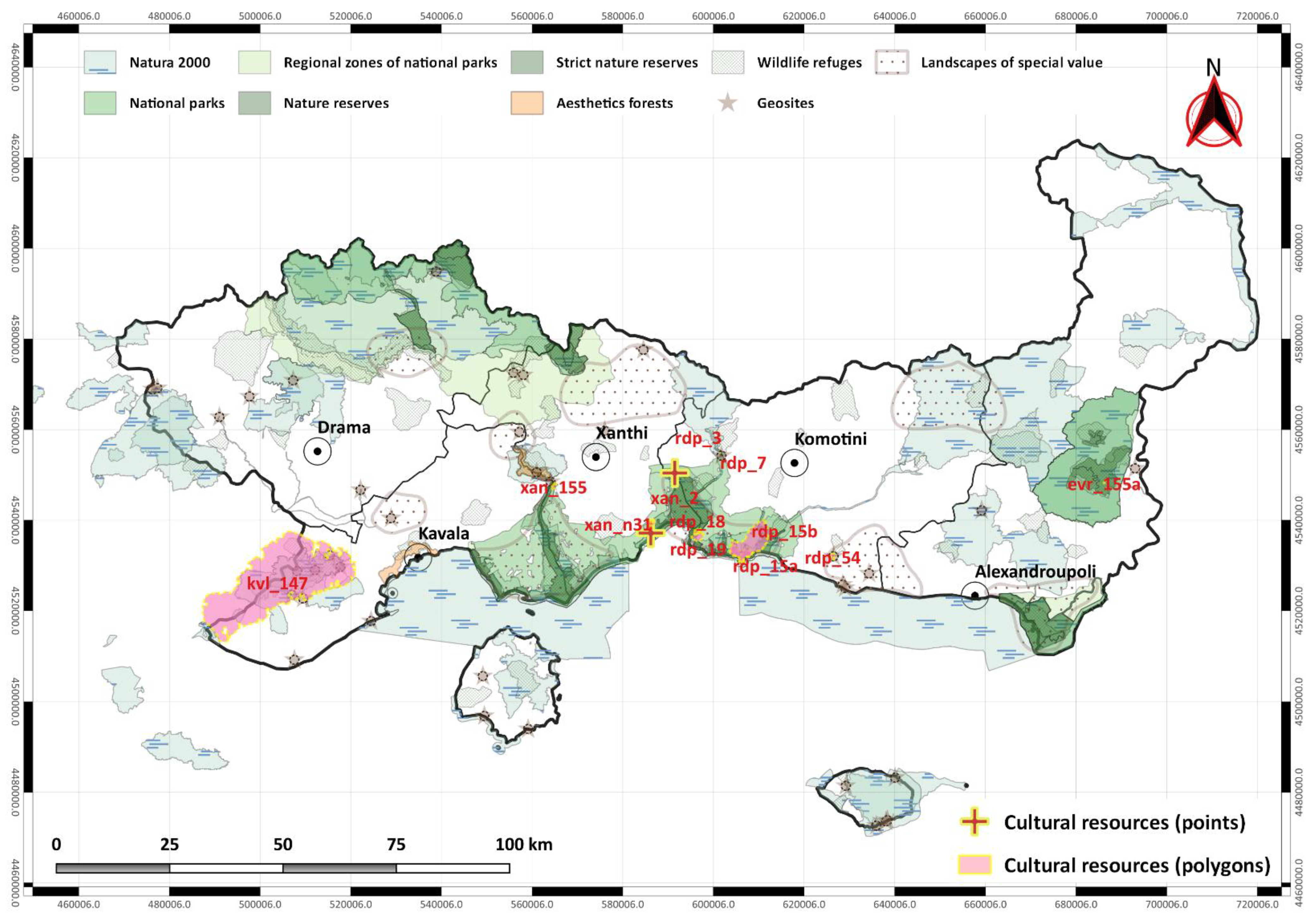
| Map Position | Culture Place | Description | Legislative Protection Regime |
|---|---|---|---|
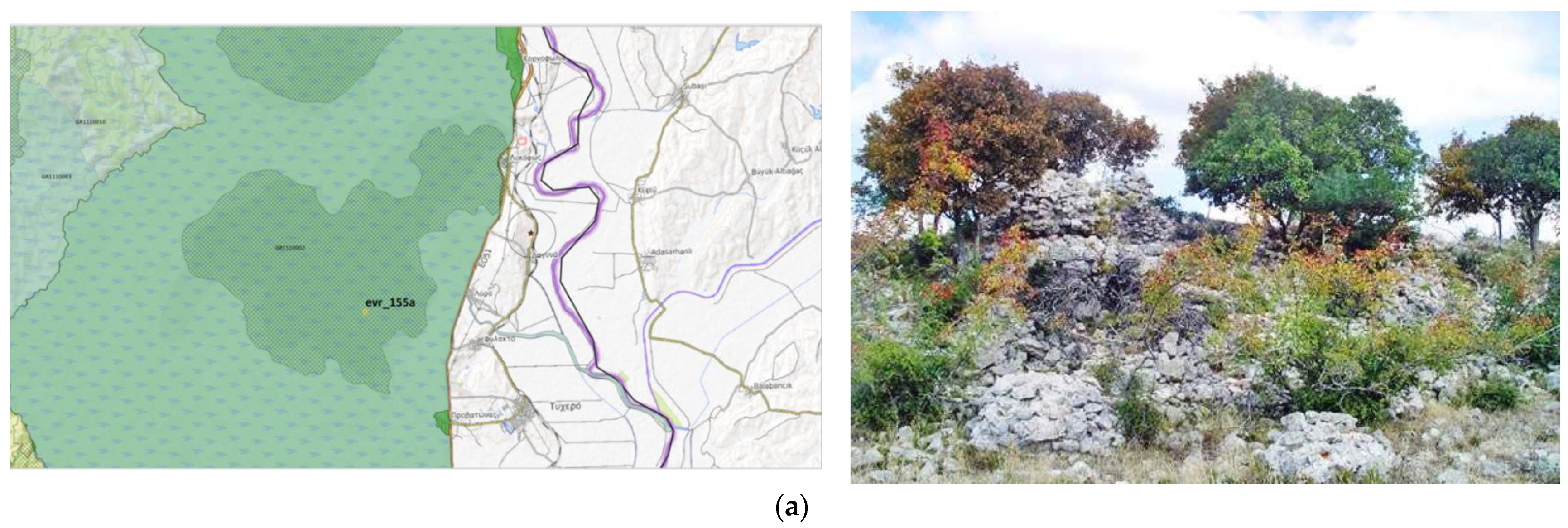
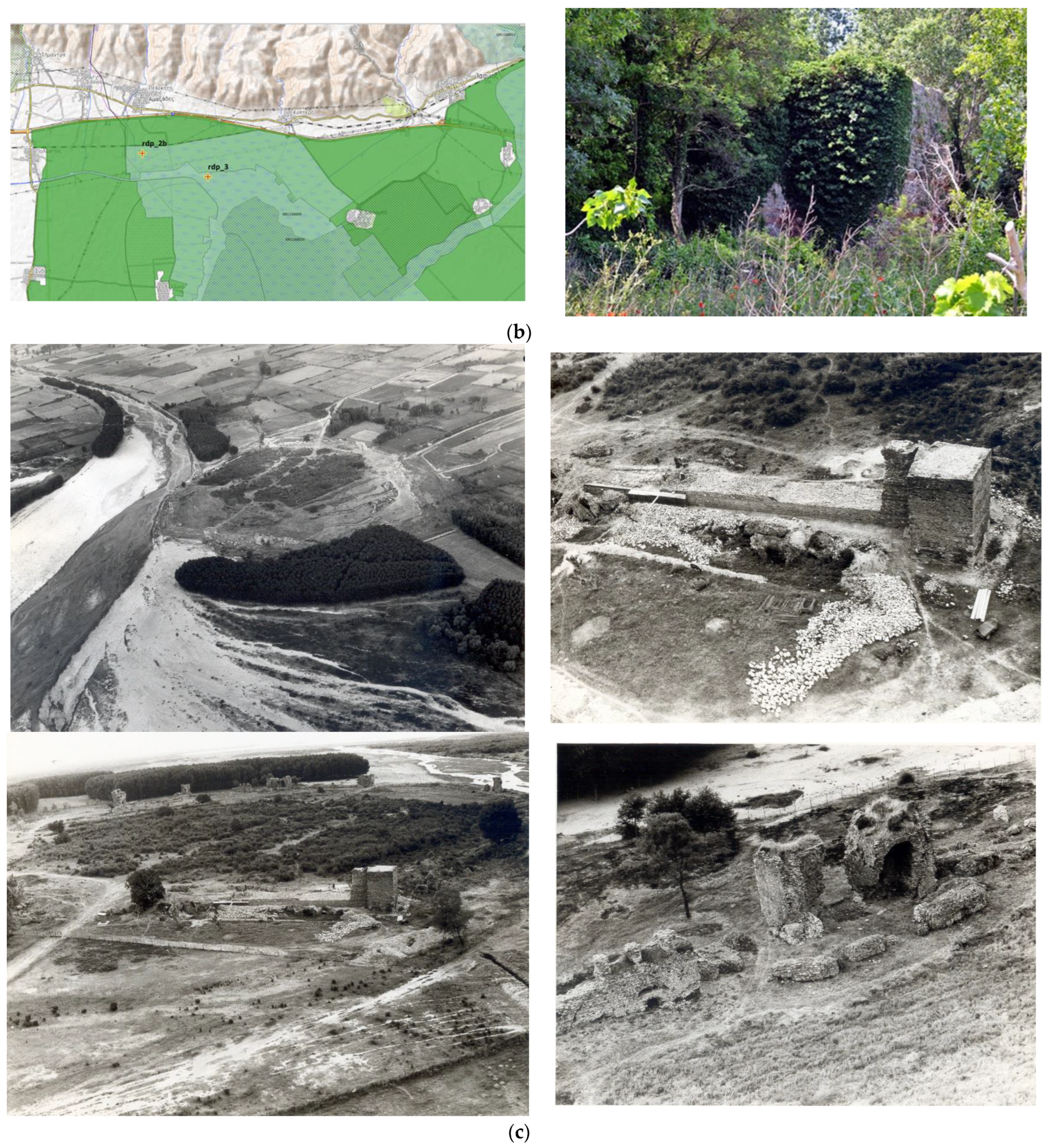
| evr_155a polygon | Fortress, Tsamtsas Kale Lefkimi | preserved ruins of a Byzantine fortress on the rocky hill of Tsamtsas Kale (possibly 6th cent.) | Natura 2000 [GR1110002 (SPA*), GR1110005 (SAC**)], National Park Dadia-Lefkimi forest, strict nature reserve area, wildlife refuge, geosite (97 fossilised trees) |
| rdp_3 polygon | Anastasioupolis/ Peritheorion | Byzantine fortified city, and a port in the lagoon of Vistonida, next to the Via Egnatia | Natura 2000 [GR1130010 (SPA), GR1130009 (SAC)], National Park Rhodope Mountain-Range, nature reserve area |
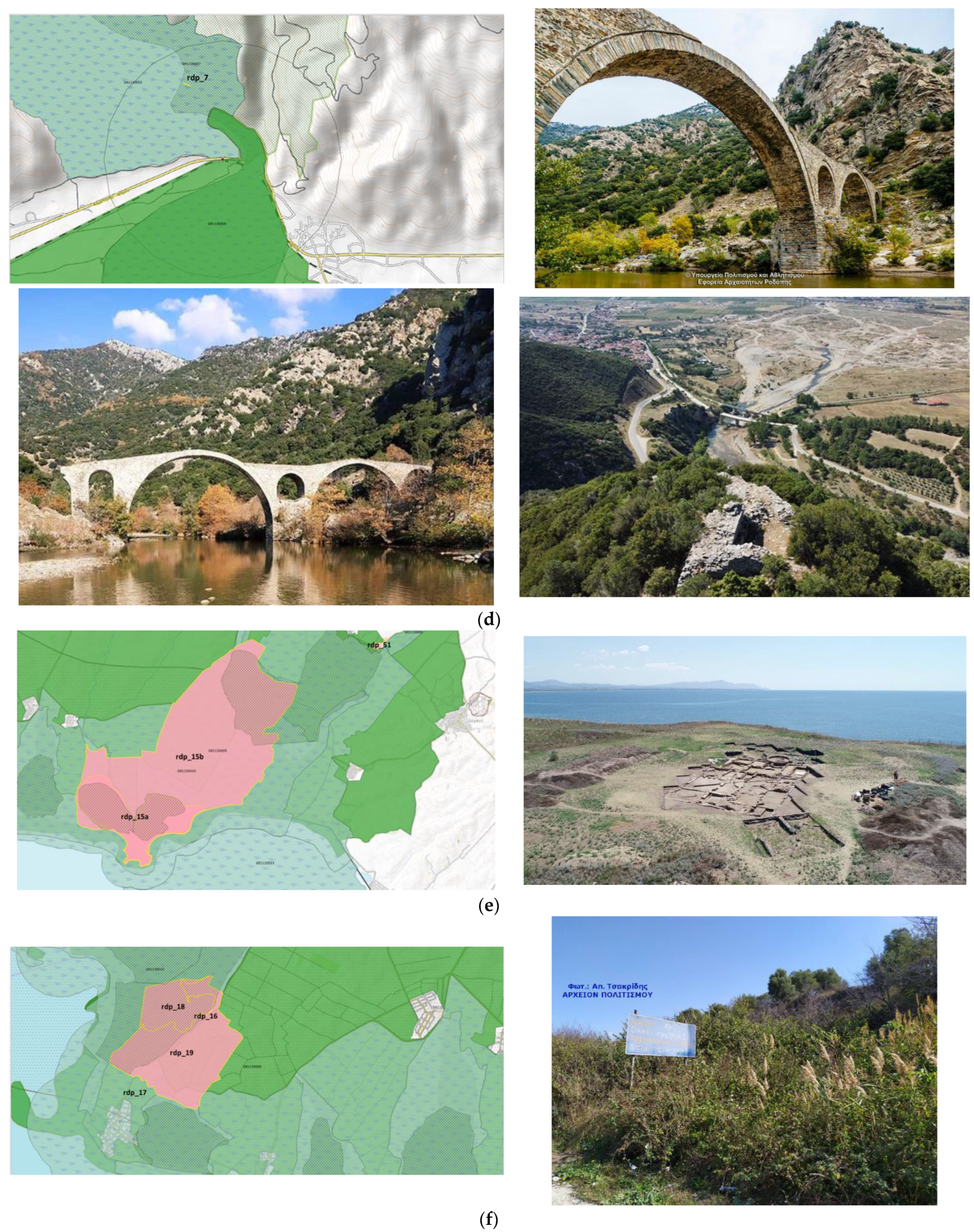
| rdp_7 point | Kompsatos Bridge, Polyanthos | bridge of triple arch built with flat stones over the river Kompsatos, Ottoman era | Natura 2000 [GR1130012 (SPA), GR1130007 (SAC)], Wildlife refuge, geosite (Thracian rift) |
| rdp_15a and rdp_15b polygons | Molyvotis Peninsula and Ancient Stryme | ruins of the Late Classical city of Strymi, which include parts of the fortification, farmhouses and cemetery, 5th–4th cent. BC | Natura 2000 [GR1130010 (SPA), GR1130009 (SAC)], National Park East Macedonia-Thrace, nature reserve area, wildlife refuge, landscapes of special value |
| rdp_18 and rdp_19 polygons | Fountain of Daout and Ancient Dikaia, Laspotopos | extensive diachronic site around the coastal settlement of Fanari, which includes (a) prehistoric settlement (NE of Fanari), (b) part of the archaic and classical city of Dikaia, natural harbour (in Daliani lagoon), archaic cemetery (at the site Fountain of Daout), ruins of fortification and dwellings, 5th century BC | Natura 2000 [GR1130010 (SPA), GR1130009 (SAC)], National Park East Macedonia-Thrace, nature reserve area, wildlife refuge, landscapes of special value |
| rdp_54 polygon | Maroneia Cave | evidence of habitation from the Late Neolithic to the Late Byzantine period | Natura 2000 [GR1130008 (SAC)], Wildlife refuge, geosite, Landscapes of special value |
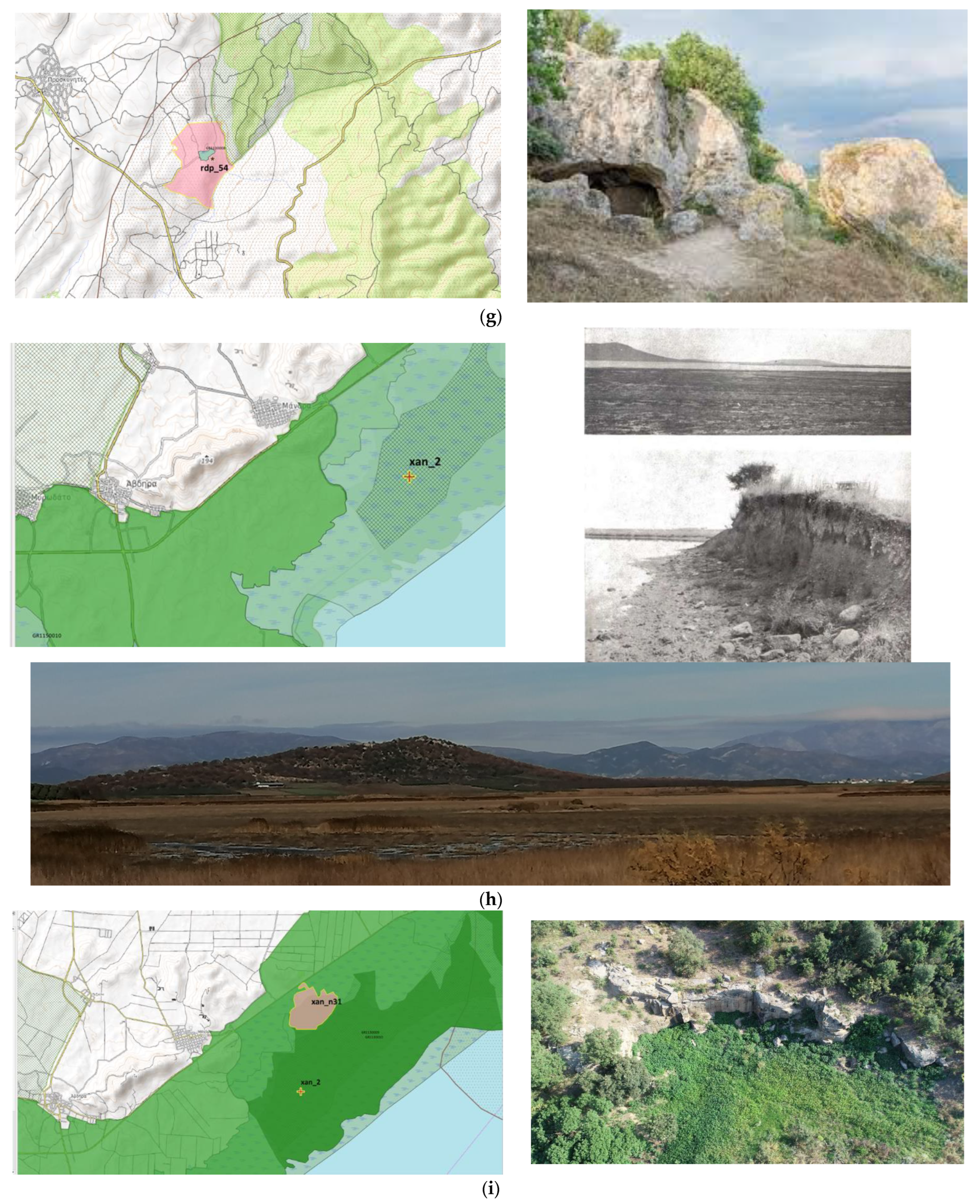
| xan_2 polygon | Settlement, Lake Lafrouda Mandra | settlement of the later Neolithic era, mid 6th millennium BC | Natura 2000 [GR1130010 (SPA), GR1130009 (SAC)], National Park East Macedonia-Thrace, Nature reserve area, Wildlife refuge |
| xan_n31 polygon | Ancient quarries, Petrolofos, Mandra Abdera | (a) scattered evidence of habitation from the Neolithic period to Imperial times (b) ancient quarries in use from the end of the 6th to the end of the 4th cent. BC | Natura 2000 [GR1130010 (SPA), GR1130009 (SAC)], National Park East Macedonia-Thrace, Nature reserve area |
| xan_155 polygon | Mount Mausoleum | Thracian settlement of the early Iron Age, settlement continued to exist from the Archaic to Roman Times | Natura 2000 [GR1150010 (SAC)], National Park Rhodope Mountain-Range, Nature reserve area, Wildlife refuge, geosite (Thracian rift) |
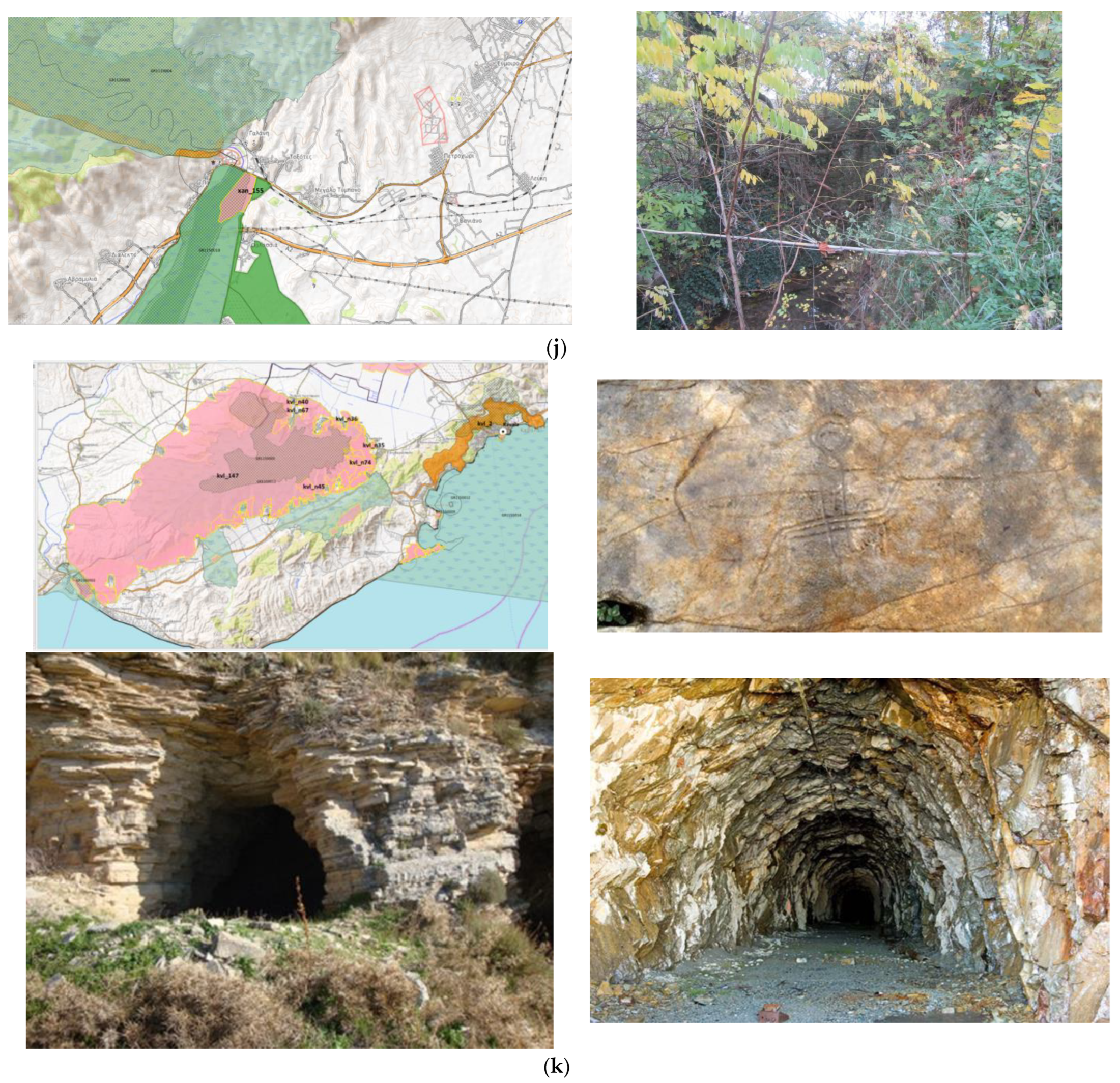
| kvl_147 polygon | Mountain Pangeo | diachronic site with dense findings from various periods, from the prehistoric to the post-Byzantine period: settlements, aqueducts, cemeteries, caves, sanctuaries, mining galleries and rusts, rock paintings and fortresses | Natura 2000 [GR1260002, GR1150011 (SPA), GR1260002, GR1150005 (SAC)], Wildlife refuge, geosite [(1224***—Peaks of Paggaeo, 1225—Silver stones in Kallithea, 1508—Black piles of rust: the remnants of old mining activity, 1227—Silverstone of Forest Village, 1234—Springs in the middle of mountains hole (Mesoropi), 1235—Lodges (Moustheni)] |
| Map Position | Monument/Archaeological Site | Visibility/Accessibility | ||||
|---|---|---|---|---|---|---|
| 1 | 2 | 3 | 4 | Conditions | ||
| evr_155a | Fortress, Tsamtsas Kale Lefkimi | X | difficult to spot, visibility depends on the season and vegetation, rather dangerous access | |||
| rdp_3 | Anastasioupolis/ Peritheorion | X | easy and safe access by provincial road, car park, short hike, marked on satellite portals /no signage, poor fencing difficult tour but possibility of hiring a sufficient image | |||
| rdp_7 | Kompsatos Bridge, Polyanthos | X | easy and safe access by provincial road, car park, short hike, marked on satellite portals /no signage | |||
| rdp_15a and rdp_15b | Molyvotis Peninsula and Ancient Stryme | X | possible to visit for an important reason judged by the protection agency | |||
| rdp_18 and rdp_19 | Fountain of Daout and Ancient Dikaia, Laspotopos | X | impossible to visit | |||
| rdp_54 | Maroneia Cave | X | ||||
| xan_2 | Settlement, Lake Lafrouda Mandra | X | difficult to locate, unsafe access | |||
| xan_n31 | Ancient quarries, Petrolofos, Mandra Abdera | X | ||||
| xan_155 | Mount Mausoleum | X | ||||
| kvl_147 | Mountain Pangeo | X | ||||
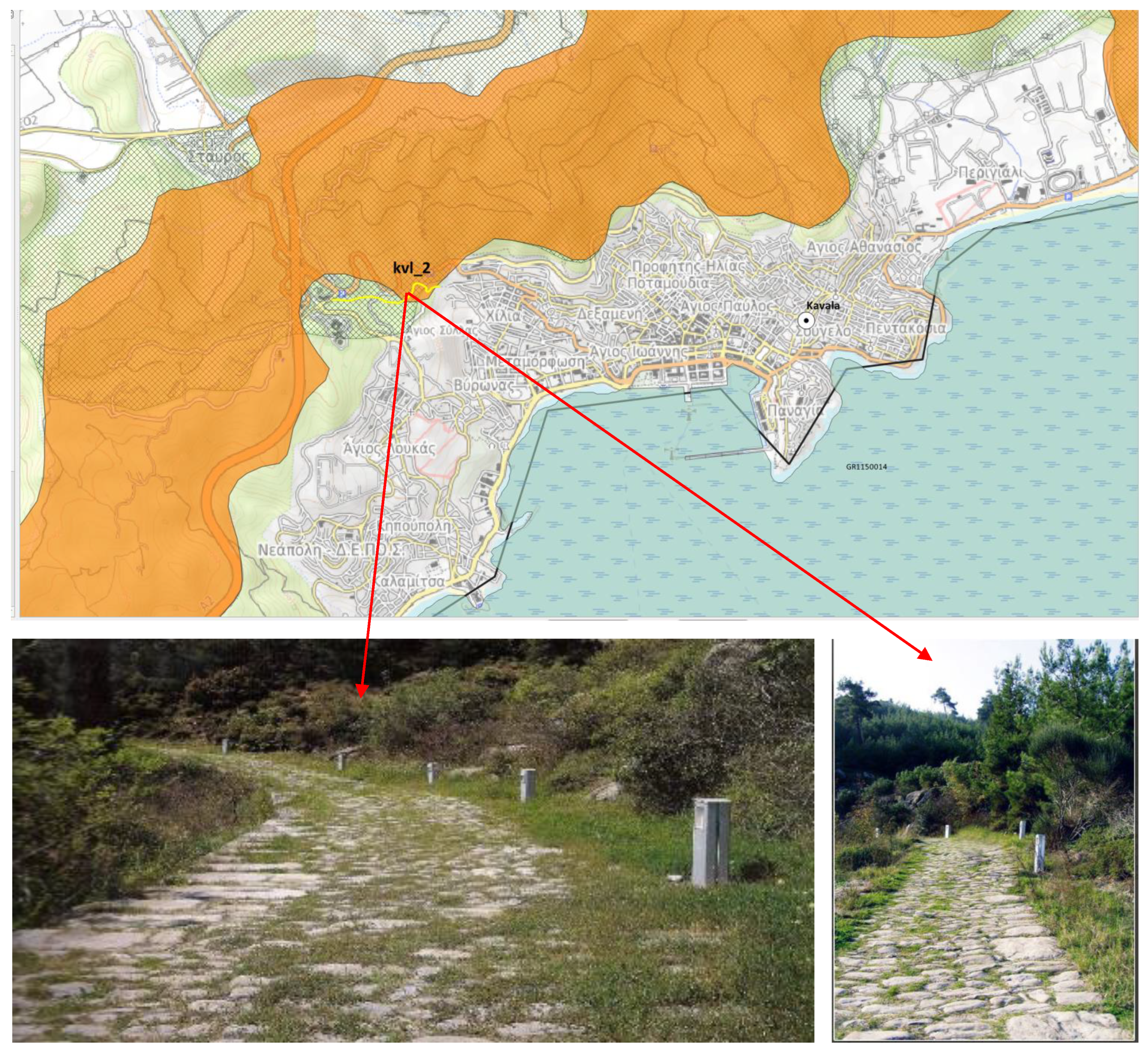
| kvl_2 | Forest Amygdaleonas/Via Egnatia | X | safe access, signage/no information about specific visit times for public | |||
| Institutional Level | Stakeholders | Environmental Perspectives, Interest, and Values | Cultural Perspectives, Interest, and Values |
|---|---|---|---|
| Global and International | Environmental agencies Future generations European Union | Biodiversity Natural resources conservation | Cultural heritage conservation Traditional activities and values |
| National | Governmental departments | Ecotourism development Environmental policy making Need for sacrificing environmental capital under criteria Intrinsic values of all plants, animals, and organisms | Sustainable tourism development Cultural policy making Intrinsic values of all cultural positions Need for sacrificing cultural capital under criteria |
| Hellenic Ministry of Culture and Sports Hellenic Ministry of Environment and Energy | |||
| Scientists | |||
| Archaeologists Engineers Environmentalists | |||
| Regional | Archaeological services Forest services Region of East Macedonia and Thrace | Policy implementation Coordination of local stakeholders | Policy implementation Coordination of local stakeholders |
| Local-off-site | Local officials People of the around villages and cities Entrepreneurs | Ecotourism development Natural heritage protection Conflict avoidance | Sustainable tourism development Cultural heritage protection Conflict avoidance |
| Local on-site | Local Authorities Management agenciesInhabitantsEntrepreneurs | Ecotourism development Emergencies and risks management Natural heritage protection | Sustainable tourism development Emergencies and risks management Cultural heritage protection |
Disclaimer/Publisher’s Note: The statements, opinions and data contained in all publications are solely those of the individual author(s) and contributor(s) and not of MDPI and/or the editor(s). MDPI and/or the editor(s) disclaim responsibility for any injury to people or property resulting from any ideas, methods, instructions or products referred to in the content. |
© 2023 by the authors. Licensee MDPI, Basel, Switzerland. This article is an open access article distributed under the terms and conditions of the Creative Commons Attribution (CC BY) license (https://creativecommons.org/licenses/by/4.0/).
Share and Cite
Keramitsoglou, K.M.; Koudoumakis, P.; Akrivopoulou, S.; Papaevaggelou, R.; Protopapas, A.L. Biodiversity as an Outstanding Universal Value for Integrated Management of Natural and Cultural Heritage. Sustainability 2023, 15, 8540. https://doi.org/10.3390/su15118540
Keramitsoglou KM, Koudoumakis P, Akrivopoulou S, Papaevaggelou R, Protopapas AL. Biodiversity as an Outstanding Universal Value for Integrated Management of Natural and Cultural Heritage. Sustainability. 2023; 15(11):8540. https://doi.org/10.3390/su15118540
Chicago/Turabian StyleKeramitsoglou, Kiriaki M., Panagiotis Koudoumakis, Sofia Akrivopoulou, Rodope Papaevaggelou, and Angelos L. Protopapas. 2023. "Biodiversity as an Outstanding Universal Value for Integrated Management of Natural and Cultural Heritage" Sustainability 15, no. 11: 8540. https://doi.org/10.3390/su15118540