
Study on the Construction of the Ecological Security Pattern of the Lancang River Basin (Yunnan Section) Based on InVEST-MSPA-Circuit Theory


Abstract
:1. Introduction
2. Overview and Data Sources of the Research Area
2.1. Overview of the Research Area
2.2. Data Sources
3. Research Methods
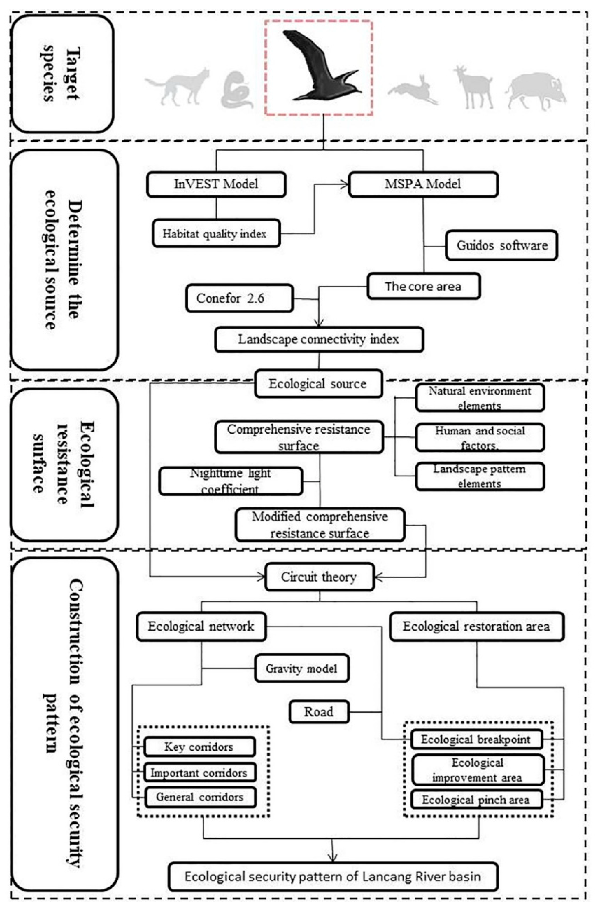
3.1. Research Framework
3.2. Target Species Selection
3.3. Methods
3.3.1. Identification of the Ecological Sources
Evaluation of Habitat Quality Based on the InVEST Model
Ecological Source Identification Based on MSPA and Landscape Connectivity Index
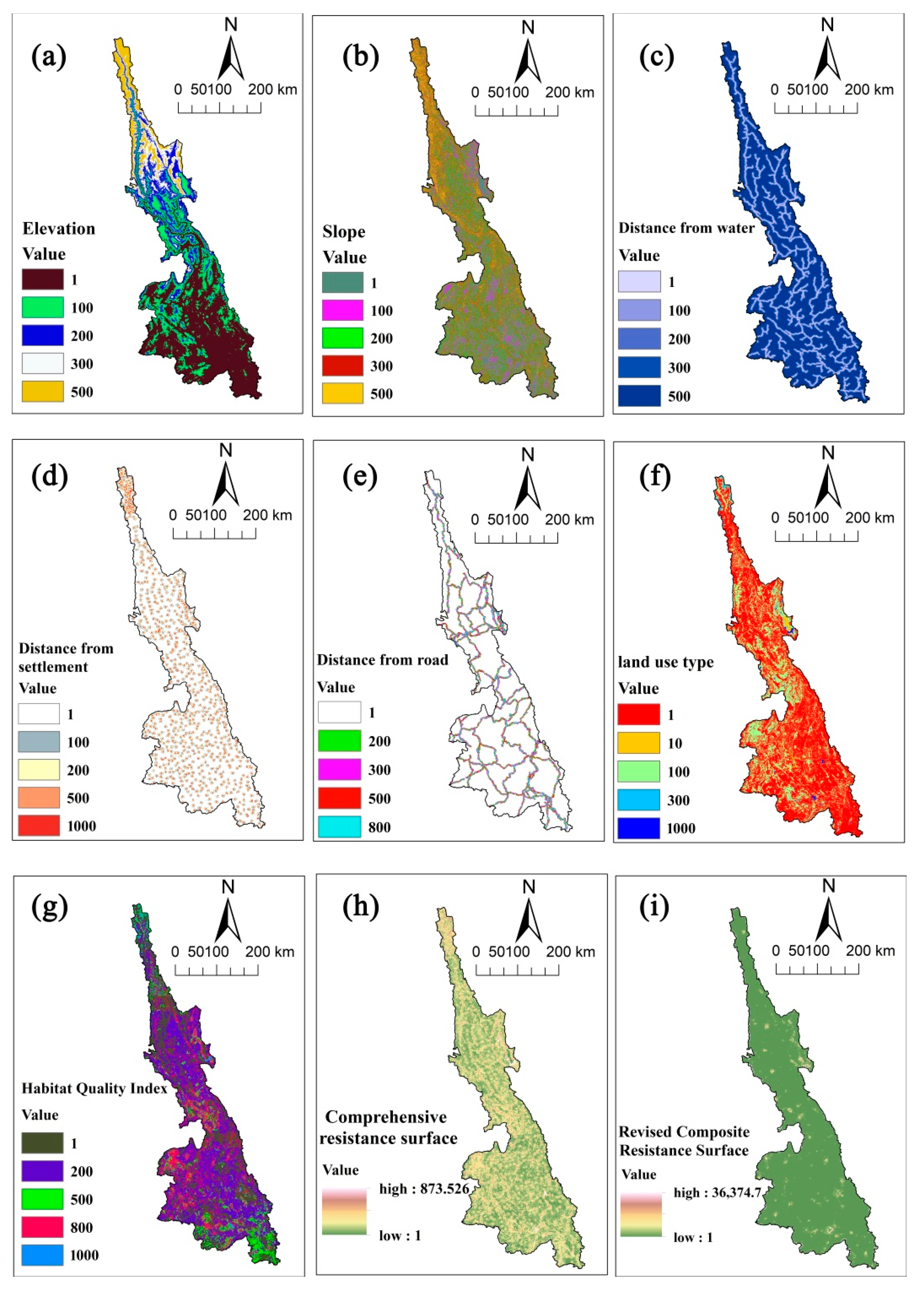
3.3.2. Construction of the Resistance Surfaces
3.3.3. Extraction and Evaluation of the Ecological Network
3.3.4. Identification of Important Nodes of the Ecological Network
4. Results and Analysis
4.1. Construction of the Ecological Security Pattern of the River Basin
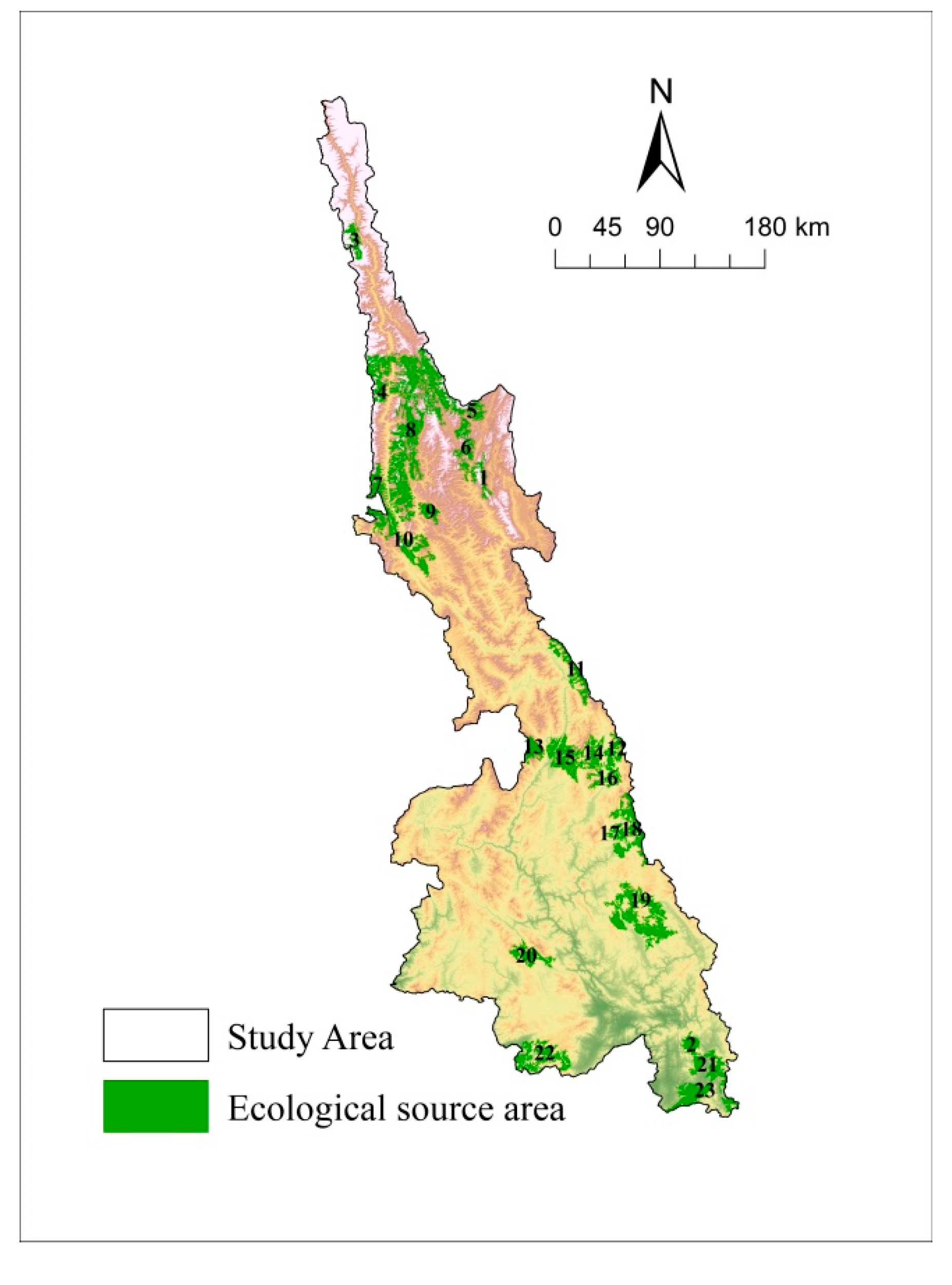
4.1.1. Identification of the Ecological Sources
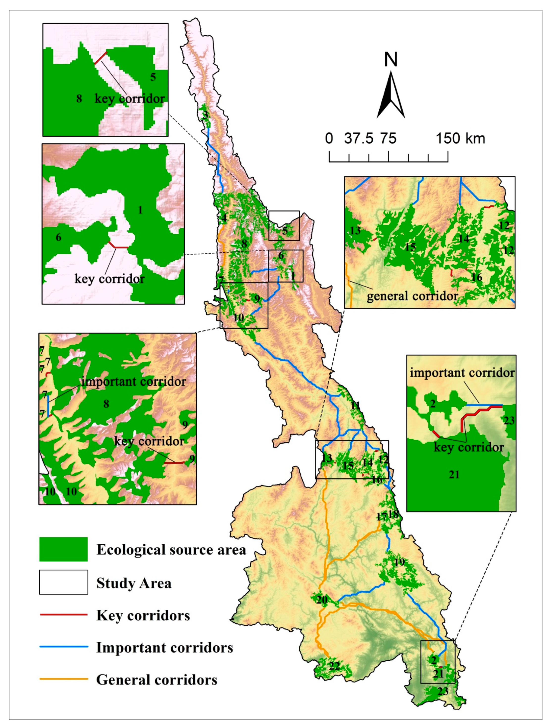
4.1.2. Evaluation of Corridor Importance and Construction of the Ecological Network
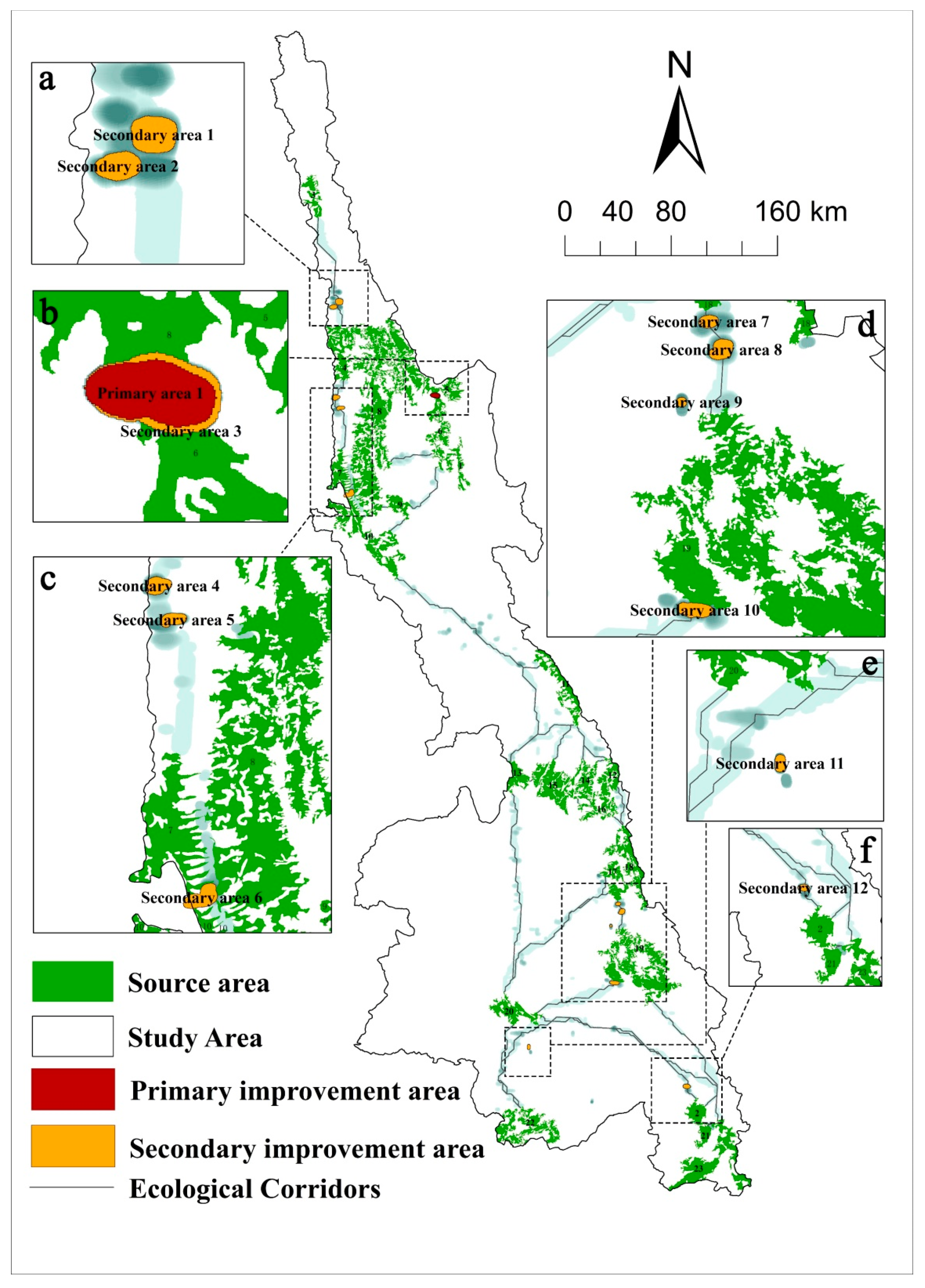
4.1.3. Identification of the Ecological Restoration Areas
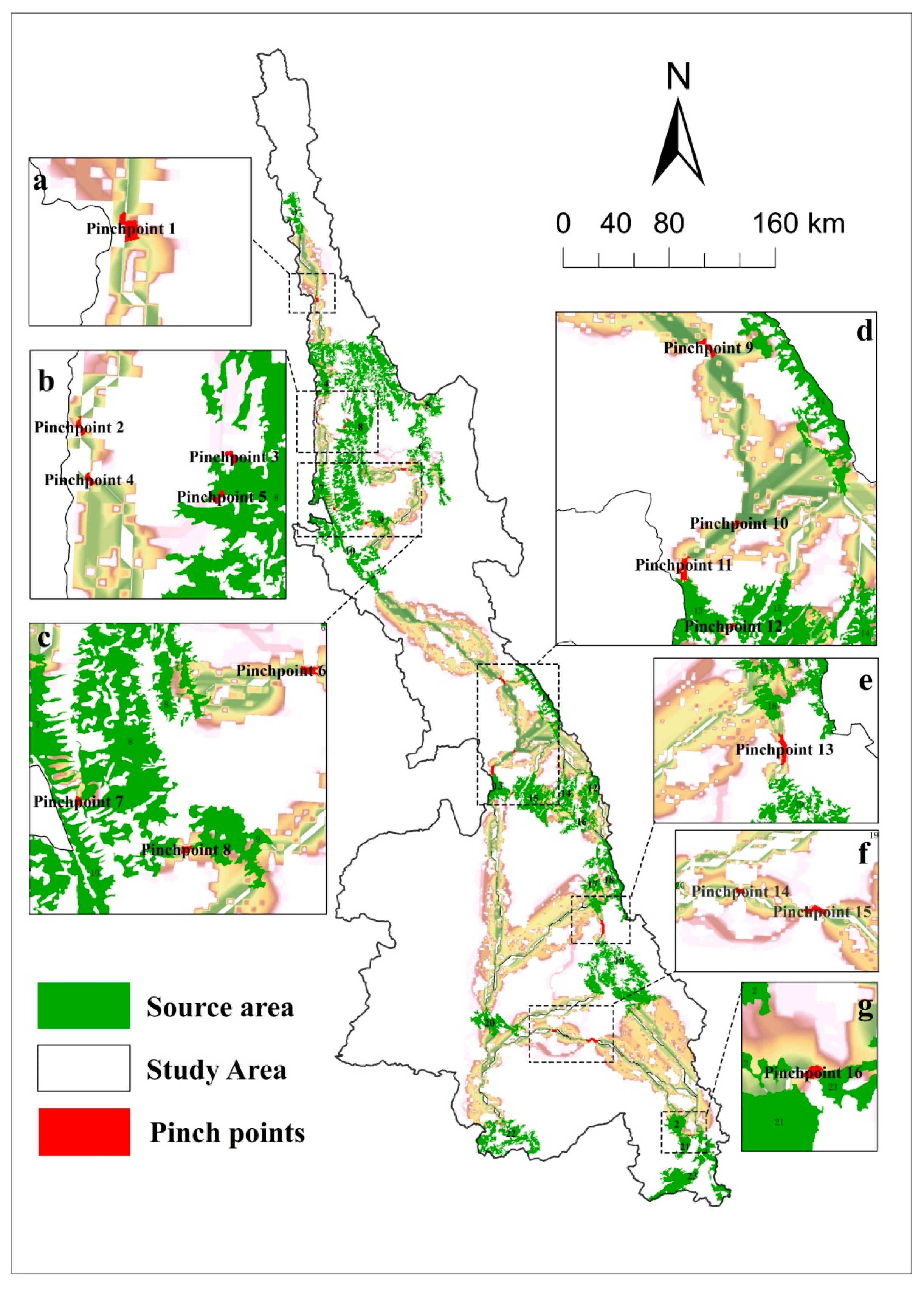
Identification of the Ecological Pinch Points and Obstacles
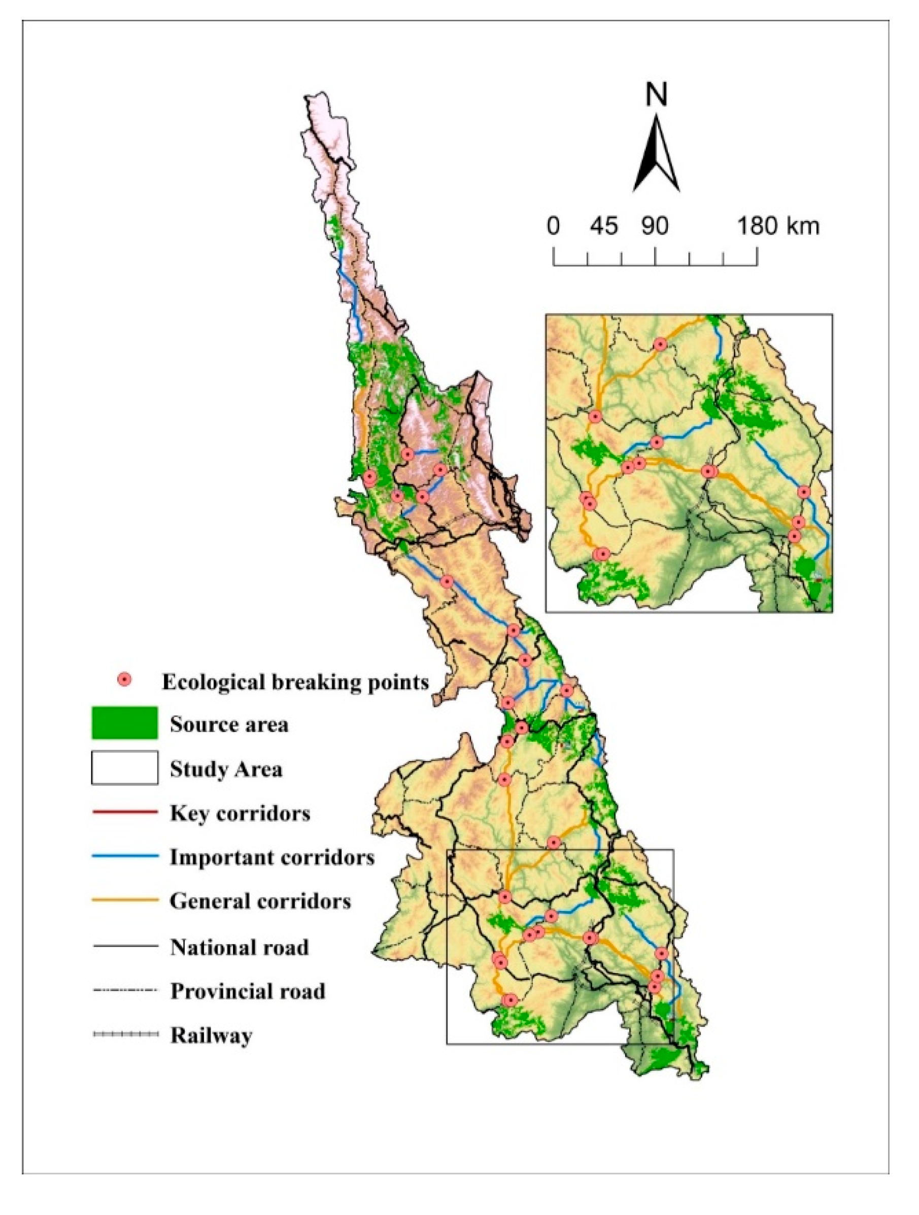
Identification and Restoration of the Ecological Breakpoints
4.1.4. Protection and Restoration Strategies Based on the Key Ecological Elements
5. Discussion
6. Conclusions
Author Contributions
Funding
Institutional Review Board Statement
Informed Consent Statement
Data Availability Statement
Acknowledgments
Conflicts of Interest
References
- Fan, J. The Strategy of Major Function Oriented Zoning and the Optimization of Territorial Development Patterns. Bull. Chin. Acad. Sci. 2013, 28, 193–206. [Google Scholar]
- Pan, Y.; Gong, J.; Yang, J.X.; Yang, T.; Wang, Y. Construction of Ecological Security Pattern Based on Ecological Importance and Connectivity of MSPA-core Area: A Case Study of Guijiang River Basin. China Land Sci. 2022, 36, 86–95. [Google Scholar]
- People’s Government of Yunnan Province. Yunnan Province’s Ecological Civilization Construction Vanguard Plan (2021–2025). Available online: http://www.yn.gov.cn/zwgk/zcwj/swwj/202205/t20220521242388.html (accessed on 21 October 2022).
- Xu, G. Research on Yunnan’s Striving to be the Vanguard of Ecological Civilization Construction. Master’s Thesis, Yunnan Normal University, Kunming, China, 2016. [Google Scholar]
- Peng, J.; Zhao, H.J.; Liu, Y.X.; Wu, J.S. Research progress and prospect on regional ecological security pattern construction. Geogr. Res. 2017, 36, 407–419. [Google Scholar]
- Wang, Y.Y.; Shen, C.Z.; Jin, X.B.; Bao, G.Y.; Liu, J.; Zhou, Y.K. Developing and optimizing ecological networks based on MSPA and MCR model. Ecol. Sci. 2019, 38, 138–145. [Google Scholar]
- Tang, F.; Fu, M.; Wang, L.; Zhang, P. Land-use change in Changli County, China: Predicting its spatio-temporal evolution in habitat quality. Ecol. Indic. 2020, 117, 106719. [Google Scholar] [CrossRef]
- Gou, M.M.; Liu, C.F.; Li, L.; Xiao, W.F.; Wang, N.; Hu, J.W. Spatiotemporal variation characteristics and scenario simulation of habitat quality in a typical basin of the Three Gorges Reservoir Area. Chin. J. Ecol. 2022, 41, 1–12. [Google Scholar]
- Wang, L.R.; Feng, X.L.; Chang, Q.; Liu, H.; Wang, J. Pattern Construction of Habitat Network for Urban Green Space Based on the Compound Model of InVEST and MCR. Chin. Landsc. Archit. 2020, 36, 113–118. [Google Scholar]
- Hao, Y.; Zhang, N.; Du, Y.J.; Wang, Y.H.; Zhang, Y.D.; Zhang, C.C. Construction of ecological security pattern based on habitat quality in Tang County, Hebei, China. Chin. J. Appl. Ecol. 2019, 30, 1015–1024. [Google Scholar]
- Soille, P.; Vogt, P. Morphological segmentation of binary patterns. Pattern Recognit. Lett. 2009, 30, 456–459. [Google Scholar] [CrossRef]
- Xu, F.; Yin, H.W.; Kong, F.H.; Xu, J.G. Developing ecological networks based on mspa and the least-cost path method—A case study in bazhong western new district. Acta Ecol. Sin. 2015, 35, 6425–6434. [Google Scholar]
- Mao, C.R.; Dai, L.M.; Qi, L.; Wang, Y.; Zhou, W.M.; Zhou, L.; Yu, D.P.; Zhao, F.Q. Constructing ecological security pattern based on ecosystem services: A case study in Liaohe River Basin, Liaoning Province, China. Acta Ecol. Sin. 2020, 40, 6486–6494. [Google Scholar]
- Fang, Y.; Wang, J.; Huang, L.Y.; Zhai, T.L. Determining and identifying key areas of ecosystem preservation and restoration for territorial spatial planning based on ecological security patterns: A case study of Yantai city. J. Nat. Resour. 2020, 35, 190–203. [Google Scholar]
- Zhu, J.; Su, J.; Yin, H.W.; Kong, F.H. Construction of Xuzhou ecological network based on comprehensive sources identification and multi-scale nesting. J. Nat. Resour. 2020, 35, 1986–2001. [Google Scholar]
- Zhou, J.; Wang, H.W.; Tan, B.; Ma, C.; Wang, X.Q.; Dai, X.Y. Construction of ecological security pattern and identification of ecological rehabilitation Zones in Kaidu River Basin. Acta Ecol. Sin. 2022, 42, 1–11. [Google Scholar]
- Dickson, B.G.; Albano, C.M.; Anantharaman, R.; Beier, P.; Fargione, J.; Graves, T.A.; Gray, M.E.; Hall, K.R.; Lawler, J.J.; Leonard, P.B.; et al. Circuit-theory applications to connectivity science and conservation. Conserv. Biol. 2018, 33, 239–249. [Google Scholar] [CrossRef]
- Tong, L.; Yao, X.J.; Wang, X. Construction of Ecological Security Pattern in Agricultural Plains Based on Circuit Theory—A Case Study of Bozhou City. Environ. Sci. Technol. 2020, 43, 217–226. [Google Scholar]
- Zhou, L.; Li, M.H.; Zhou, Q.G.; Meng, H.B.; Peng, C.H.; Liu, X.W. Construction of Ecological Security Pattern in Very Large Mountainous City Based on Circuit Theory—Taking Chongqing Metropolitan Area as an Example. Res. Soil Water Conserv. 2021, 28, 319–325. [Google Scholar]
- Li, J.L.; Xu, J.G.; Chu, J.L. Constructing the Urban Ecological Security Pattern of Anqing City by Circuit Theory. Resour. Environ. Yangtze Basin 2020, 29, 1812–1824. [Google Scholar]
- Yang, S.S.; Zou, C.X.; Shen, W.S.; Shen, R.P.; Xu, D.L. Construction of ecological security patterns based on ecological red line—A case study of Jiangxi Province. Acta Ecol. Sin. 2016, 35, 250–258. [Google Scholar]
- Chen, X.; Peng, J.; Liu, Y.X.; Yang, Y.; Li, G.C. Constructing ecological security patterns in Yunfu city based on the framework of importance-sensitivity-connectivity. Geogr. Res. 2017, 36, 471–484. [Google Scholar]
- Zhang, M.F.; Chen, P.; Liu, B.W.; Gou, D.W.; Gong, Q.H. Construction of Natural Reserve Network in Shantou CityBased on Minimum Cumulative Resistance Model. Guangdong Agric. Sci. 2020, 47, 119–127. [Google Scholar]
- Zheng, Q.M.; Shen, M.Z.; Zhong, L.S. Construction of ecological security pattern in Pudacuo National Park. Acta Ecol. Sin. 2021, 41, 874–885. [Google Scholar]
- Xia, Y.; Zhang, Y.Y.; Li, E.H.; Cai, X.B.; Yang, C.; Yang, J. Spatio-temporal Evolution and Prediction of Habitat Quality in Four Lakes Basin of Jianghan Plain. Resour. Environ. Yangtze Basin 2022, 31, 1616–1626. [Google Scholar]
- Pan, Y.; Yin, Y.H.; Hou, W.J.; Han, H.S. Spatiotemporal variation of habitat quality in the Source Region of the Yellow River based on land use and vegetation cover changes. Acta Ecol. Sin. 2022, 42, 7978–7988. [Google Scholar]
- Cheng, S.K.; Shen, L.; Xu, Z.R. A Comprehensive Study of Scientific Expedition in Lancang River Basin and Greater Shangri-La Region; Science Press: Beijing, China, 2015; pp. 1–26. [Google Scholar]
- Zhao, J.; Liang, R.Q.; Mei, J. Target Species Oriented Construction of Urban Habitat Network. In Proceedings of the 2020 Annual Conference of the China Society of Landscape Architecture, Chengdu, China, 21 November 2020; China Architecture & Building Press: Beijing, China, 2021; Volume 1, pp. 607–612. [Google Scholar]
- Cao, J.J.; Fu, J.W. Research on the construction method of urban green space habitat network based on InVEST model and Least-cost path: A case study of Nanjing. Chin. Landsc. Archit. 2022, 38, 1–10. [Google Scholar]
- Pereira, H.M.; Cooper, H.D. Towards the global monitoring of biodiversity change. Trends Ecol. Evol. 2006, 21, 123–129. [Google Scholar] [CrossRef]
- Chowfin, S.M.; Leslie, A.J. Using birds as biodindicators of forest restoration progress: A preliminary study. Trees For. People 2021, 3, 100048. [Google Scholar] [CrossRef]
- Peng, J.; Pan, Y.J.; Zhao, H.J.; Wang, Y.L. Linking ecological degradation risk to identify ecological security patterns in a rapidly urbanizing landscape. Habitat Int. 2018, 71, 110–124. [Google Scholar] [CrossRef]
- Huang, M.Y.; Yue, W.Z.; Feng, S.R.; Zhang, J.H. Spatial-temporal evolution of habitat quality and analysis of landscape patterns in Dabie Mountain area of west Anhui province based on InVEST model. Acta Ecol. Sin. 2020, 40, 2895–2906. [Google Scholar]
- Li, X.; Yang, J.M.; Chen, Y.H.; Mao, L.F.; Ge, Z.W. Evaluations of habitat quality of Jiangsu Yancheng Wetland National Nature Rare Bird Reserve based on land use changes. J. Nanjing For. Univ. (Nat. Sci. Ed.) 2022, 46, 169–176. [Google Scholar]
- Zhao, Q.J.; Wu, X.Z. Research on the impact of land use change on habitat quality in Minjiang river basin based on InVEST Model. Ecol. Sci. 2022, 41, 1–10. [Google Scholar]
- Ding, Q.; Chen, Y.; Bu, L.; Ye, Y. Multi-scenario analysis of habitat quality in the Yellow River delta by coupling FLUS with InVEST model. Int. J. Environ. Res. Public Health 2021, 18, 2389. [Google Scholar] [CrossRef]
- Jang, J.E.; Kwon, H.Y.; Shin, H.S.; Lee, S.C.; Yu, B.H.; Jang, J.; Choi, S.H. Habitat Quality Analysis and Evaluation of InVEST Model Using QGIS-Conducted in 21 National Parks of Korea. Korean J. Environ. Ecol. 2022, 36, 102–111. [Google Scholar] [CrossRef]
- Ning, Q.; Zhu, Z.M.; Qin, M.L.; Shi, Q.Q.; Song, Y.Z. Research on the optimization of territorial space ecological network of Nanning City based on MSPA and circuit theory. J. Guangxi Univ. (Nat. Sci. Ed.) 2021, 46, 306–318. [Google Scholar]
- Xu, W.Z.; Huang, S.Y.; Geng, J.W.; Wang, X.Y.; Fu, W.C.; Lin, S.Y.; Dong, J.W. Construction of Ecological Space Network in Xiamen City Based on MCR and Gravity Model. J. Northwest For. Univ. 2022, 37, 264–272. [Google Scholar]
- Qin, B.G.; Lin, Y.L.; Zhao, J.S.; Chen, G.P.; He, W.C.; Lv, Q.Z. Identification of Key Areas for the Ecological Restoration of Territorial Space in Kunming Based on the InVEST Model and Circuit Theory. China Environ. Sci. 2022, 42, 1–12. [Google Scholar]
- Zhang, H.L.; Ye, C.S.; Hu, M.S. Identification and Restoration Strategy of Key Areas of Ecological Restoration in Urban Agglomeration around Poyang Lake Based on Ecological Security Pattern. Res. Soil Water Conserv. 2022, 29, 1–10. [Google Scholar]
- Meng, J.J.; Wang, Y.; Wang, X.D.; Zhou, Z.; Sun, N. Construction of landscape ecological security pattern in Guiyang based on MCR model. Resour. Environ. Yangtze Basin 2016, 25, 1052–1061. [Google Scholar]
- Chen, N.N.; Kang, S.Z.; Zhao, Y.H.; Zhou, Y.J.; Yan, J.; Lu, Y.R. Construction of ecological network in Qinling Mountains of Shaanxi, China based on MSPA and MCR model. Chin. J. Appl. Ecol. 2021, 32, 1545–1553. [Google Scholar]
- Ni, Q.L. Key Arca Identification of County Ecological Restoration Based on Ecological Network—A Case Study of Jiawang District. Master’s Thesis, China University of Mining and Technology, Xuzhou, China, 2021. [Google Scholar]
- Wu, J.S.; Zhang, L.Q.; Peng, J.; Feng, J.; Liu, H.M.; He, S.B. The integrated recognition of the source area of the urban ecological security pattern in Shenzhen. Acta Ecol. Sin. 2013, 33, 4125–4133. [Google Scholar]

| Threat Factors | Maximum Influence | Weight | Attenuation Mode |
|---|---|---|---|
| Drylands | 8 | 0.7 | Linear |
| Paddy fields | 8 | 0.7 | Linear |
| Rural residential areas | 5 | 0.6 | Index |
| Urban land uses | 10 | 1 | Index |
| Other construction lands | 5 | 0.5 | Index |
| Major Land Types | Ground Class Code | Land-Use Types | Habitat Suitability | Paddy Fields | Drylands | Rural Settlements | Urban Lands | Other Construction Lands |
|---|---|---|---|---|---|---|---|---|
| Plough | 11 | Paddy field | 0.4 | 0.3 | 0.3 | 0.6 | 0.7 | 0.5 |
| 12 | Dryland | 0.3 | 0.3 | 0.3 | 0.6 | 0.6 | 0.4 | |
| Woodland | 21 | Forested land | 1 | 0.6 | 0.6 | 0.8 | 0.9 | 0.8 |
| 22 | Spinney | 0.8 | 0.6 | 0.6 | 0.6 | 0.8 | 0.7 | |
| 23 | Sparse woodland | 0.7 | 0.5 | 0.5 | 0.7 | 0.7 | 0.4 | |
| 24 | Other woodlands | 0.6 | 0.5 | 0.5 | 0.7 | 0.7 | 0.8 | |
| Lawn | 31 | High coverage grassland | 0.7 | 0.6 | 0.6 | 0.7 | 0.7 | 0.7 |
| 32 | Medium coverage grassland | 0.6 | 0.5 | 0.5 | 0.7 | 0.7 | 0.7 | |
| 33 | Low coverage grassland | 0.5 | 0.5 | 0.5 | 0.7 | 0.7 | 0.7 | |
| Water | 41 | Rivers and canals | 1 | 0.6 | 0.6 | 0.7 | 0.9 | 0.8 |
| 42 | Lake | 1 | 0.6 | 0.6 | 0.7 | 0.9 | 0.8 | |
| 43 | Reservoir pit pond | 0.8 | 0.5 | 0.5 | 0.6 | 0.9 | 0.8 | |
| 44 | Permanent glacier and snow | 0 | 0 | 0 | 0 | 0 | 0 | |
| 46 | Beachland | 0.5 | 0.5 | 0.5 | 0.6 | 0.9 | 0.8 | |
| Construction lands | 51 | Urban land | 0 | 0 | 0 | 0 | 0 | 0.2 |
| 52 | Rural settlements | 0 | 0 | 0 | 0 | 0 | 0.7 | |
| 53 | Other construction lands | 0 | 0 | 0 | 0.6 | 0.7 | 0 | |
| Unused land | 64 | Marshland | 0.5 | 0.4 | 0.4 | 0.4 | 0.4 | 0.3 |
| 65 | Barren earth | 0 | 0 | 0 | 0 | 0 | 0 | |
| 66 | Bare rock texture | 0 | 0 | 0 | 0 | 0 | 0 |
| Level | Evaluation Factor | Grading Criteria | Drag Coefficient | Weight |
|---|---|---|---|---|
| Natural environmental factors | Slope | 0–5 | 1 | 0.0834 |
| 5–15 | 100 | |||
| 15–25 | 200 | |||
| 25–35 | 300 | |||
| >35 | 500 | |||
| Elevation | <1500 | 1 | 0.0357 | |
| 1500–2000 | 100 | |||
| 2000–2500 | 200 | |||
| 2500–3000 | 300 | |||
| >3000 | 500 | |||
| Distance from the water system | 0–500 | 1 | 0.0225 | |
| 500–1500 | 100 | |||
| 1500–2500 | 200 | |||
| 2500–3500 | 300 | |||
| >3500 | 500 | |||
| Social and economic elements | Distance from road | 0–500 | 800 | 0.0834 |
| 500–1000 | 500 | |||
| 1000–1500 | 300 | |||
| 1500–2000 | 200 | |||
| >2000 | 1 | |||
| Distance from the residential area | 0–1000 | 1,000 | 0.2503 | |
| 1000–2000 | 500 | |||
| 2000–3000 | 200 | |||
| 3000–4000 | 100 | |||
| >4000 | 1 | |||
| Ecological pattern elements | Land use type | Plough | 100 | 0.3498 |
| Woodland | 1 | |||
| Lawn | 100 | |||
| Waters | 10 | |||
| Land for construction | 1000 | |||
| Unused land | 300 | |||
| Habitat quality index | 0 | 1000 | 0.1749 | |
| 0–0.4 | 800 | |||
| 0.4–0.7 | 500 | |||
| 0.7–0.8 | 200 | |||
| 0.8–1 | 1 |
| Circuit Factors | Corresponding Ecological Terms | Ecological Meaning |
|---|---|---|
| Power Supply | Ecological source | Habitat in the region with high quality and suitable for species survival |
| Electric current | Source connectivity | The net number of times the specified species (wanderers) in the habitat leave the nest area for evacuation and migration and pass through the landscape nodes before reaching the target nest area is proportional to the probability of net migration through the corresponding landscape nodes; a high-current-density area forms a “radiation path” to a certain extent |
| Electric conductance | Habitat suitability | Habitat suitability refers to the capacity of the habitat and is directly proportional to the diffusion ability of the species |
| Electric resistance | Landscape resistance | The impedance encountered by species migration or diffusion in habitats is directly proportional to the challenges in migration |
| Voltage | Source connectivity probability | The net migration probability of any species (random walkers) in the habitat leaving the nest for migration and successfully reaching the designated landscape node or nest source is the basis for the selection of the possible connectivity index |
| Landscape Types | Area (km2) | Proportion of Foreground Elements (%) | Proportion of Total Area (%) |
|---|---|---|---|
| Core | 21,972.60 | 83.84 | 23.80 |
| Islet | 5.69 | 0.02 | 0.01 |
| Perforation | 454.56 | 1.73 | 0.49 |
| Edge | 3422.63 | 13.06 | 3.71 |
| Bridge | 76.82 | 0.29 | 0.08 |
| Loop | 14.11 | 0.05 | 0.02 |
| Branch | 259.96 | 0.99 | 0.28 |
| Serial Number | Source Number | dpc * | Serial Number | Source Number | dpc * |
|---|---|---|---|---|---|
| 1 | 10 | 72.08984 | 13 | 7 | 2.723802 |
| 2 | 13 | 19.42792 | 14 | 21 | 1.590649 |
| 3 | 6 | 11.40909 | 15 | 28 | 1.554688 |
| 4 | 9 | 7.514814 | 16 | 42 | 1.211476 |
| 5 | 23 | 5.423434 | 17 | 20 | 1.211075 |
| 6 | 32 | 4.78267 | 18 | 40 | 1.125012 |
| 7 | 4 | 4.769856 | 19 | 41 | 0.978304 |
| 8 | 22 | 4.641909 | 20 | 34 | 0.685949 |
| 9 | 5 | 4.442316 | 21 | 26 | 0.510728 |
| 10 | 43 | 3.716952 | 22 | 3 | 0.509328 |
| 11 | 24 | 3.612249 | 23 | 19 | 0.501599 |
| 12 | 11 | 3.018604 |
Disclaimer/Publisher’s Note: The statements, opinions and data contained in all publications are solely those of the individual author(s) and contributor(s) and not of MDPI and/or the editor(s). MDPI and/or the editor(s) disclaim responsibility for any injury to people or property resulting from any ideas, methods, instructions or products referred to in the content. |
© 2022 by the authors. Licensee MDPI, Basel, Switzerland. This article is an open access article distributed under the terms and conditions of the Creative Commons Attribution (CC BY) license (https://creativecommons.org/licenses/by/4.0/).
Share and Cite
Wang, Y.; Zhang, L.; Song, Y. Study on the Construction of the Ecological Security Pattern of the Lancang River Basin (Yunnan Section) Based on InVEST-MSPA-Circuit Theory. Sustainability 2023, 15, 477. https://doi.org/10.3390/su15010477
Wang Y, Zhang L, Song Y. Study on the Construction of the Ecological Security Pattern of the Lancang River Basin (Yunnan Section) Based on InVEST-MSPA-Circuit Theory. Sustainability. 2023; 15(1):477. https://doi.org/10.3390/su15010477
Chicago/Turabian StyleWang, Yi, Long Zhang, and Yuhong Song. 2023. "Study on the Construction of the Ecological Security Pattern of the Lancang River Basin (Yunnan Section) Based on InVEST-MSPA-Circuit Theory" Sustainability 15, no. 1: 477. https://doi.org/10.3390/su15010477
APA StyleWang, Y., Zhang, L., & Song, Y. (2023). Study on the Construction of the Ecological Security Pattern of the Lancang River Basin (Yunnan Section) Based on InVEST-MSPA-Circuit Theory. Sustainability, 15(1), 477. https://doi.org/10.3390/su15010477