
Remote Sensing Prediction Model of Cultivated Land Soil Organic Matter Considering the Best Time Window


 ,
,
Abstract
:1. Introduction
2. Materials and Methods
2.1. Study Area
2.2. Data Acquisition and Processing
2.2.1. Soil Data Acquisition
2.2.2. Sentinel-2 Remote Sensing Image Acquisition and Preprocessing
2.3. Construction of the Spectral Index
2.4. RF Prediction Model
2.5. Model Validation and Establishment
2.6. Technology Roadmap
3. Results
3.1. Descriptive Statistics of SOM Content
3.2. Analysis of Spectral Characteristics of Different SOM Contents
3.3. SOM Prediction Using Single-Phase Images
3.4. SOM Prediction Using Synthetic Images
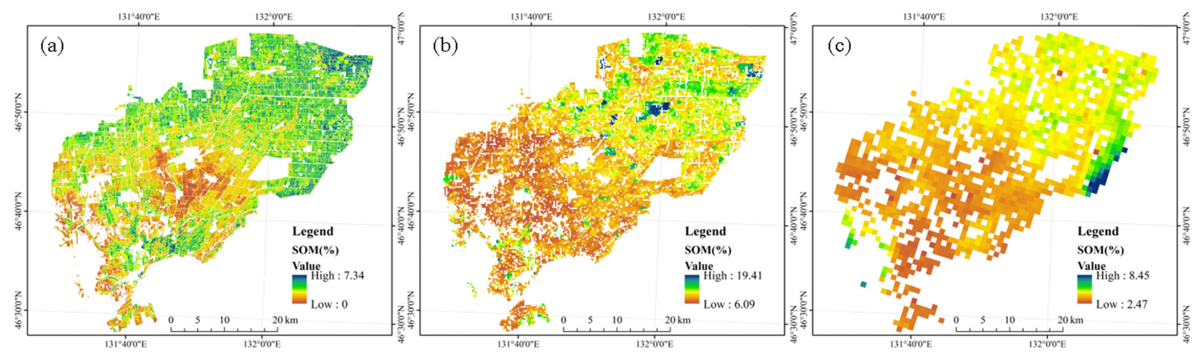
3.5. Spatial Distribution of SOM Content
4. Discussion
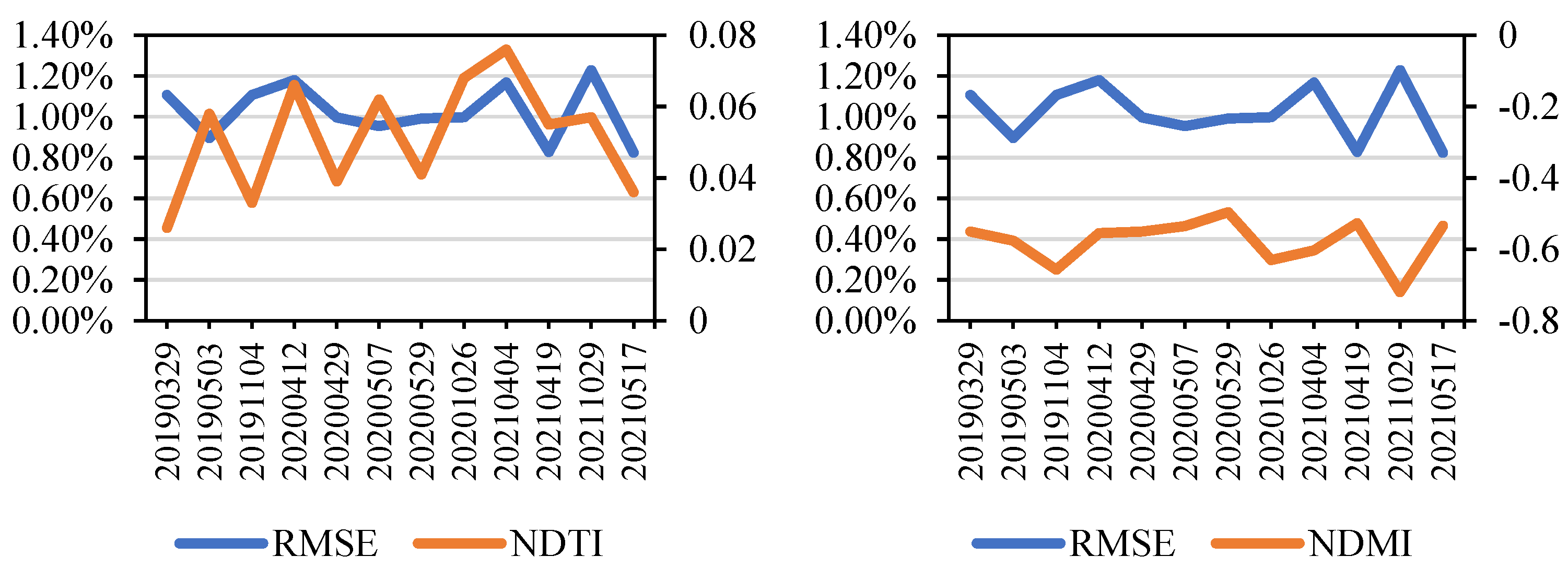
4.1. Selection of the Best Window
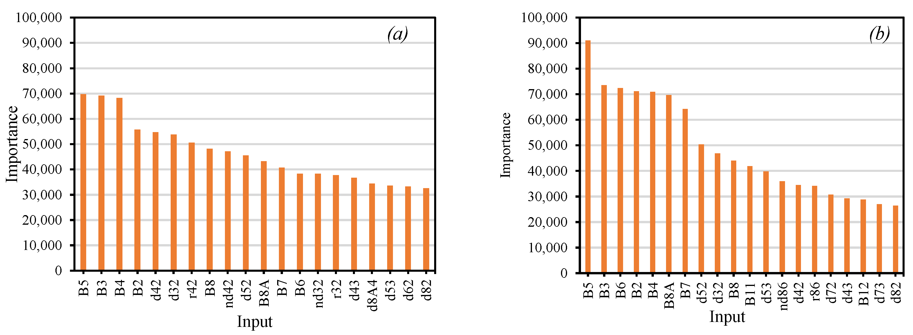
4.2. Factors Affecting the Prediction Accuracy of SOM Content
4.3. Differences between Single-Temporal and Multi-Temporal Synthetic Images
4.4. Comparison of Different SOM Content Mapping Results
4.5. Limitations and Prospects
5. Conclusions
Author Contributions
Funding
Institutional Review Board Statement
Informed Consent Statement
Data Availability Statement
Conflicts of Interest
References
- Kallenbach, C.M.; Frey, S.D.; Grandy, A.S. Direct evidence for microbial-derived soil organic matter formation and its ecophysiological controls. Nat. Commun. 2016, 7, 1–10. [Google Scholar] [CrossRef] [PubMed] [Green Version]
- Tadini, A.M.; Xavier, A.A.; Milori, D.M.; Oliveira, P.P.; Pezzopane, J.R.; Bernardi, A.C.; Martin-Neto, L. Evaluation of soil organic matter from integrated production systems using laser-induced fluorescence spectroscopy. Soil Tillage Res. 2021, 211, 105001. [Google Scholar] [CrossRef]
- Lal, R. Soil carbon management and climate change. Carbon Manag. 2013, 4, 439–462. [Google Scholar] [CrossRef]
- Lal, R. Soil carbon dynamics in cropland and rangeland. Environ. Pollut. 2002, 116, 353–362. [Google Scholar] [CrossRef]
- Soon, Y.; Arshad, M.; Haq, A.; Lupwayi, N. The influence of 12 years of tillage and crop rotation on total and labile organic carbon in a sandy loam soil. Soil Tillage Res. 2007, 95, 38–46. [Google Scholar] [CrossRef]
- Dube, E.; Chiduza, C.; Muchaonyerwa, P. Conservation agriculture effects on soil organic matter on a Haplic Cambisol after four years of maize–oat and maize–grazing vetch rotations in South Africa. Soil Tillage Res. 2012, 123, 21–28. [Google Scholar] [CrossRef]
- Lal, R. Soil carbon sequestration impacts on global climate change and food security. Science 2004, 304, 1623–1627. [Google Scholar] [CrossRef] [Green Version]
- Van der Werf, G.R.; Randerson, J.T.; Collatz, G.J.; Giglio, L. Carbon emissions from fires in tropical and subtropical ecosystems. Glob. Change Biol. 2003, 9, 547–562. [Google Scholar] [CrossRef] [Green Version]
- Gong, W.; Yan, X.; Wang, J.; Hu, T.; Gong, Y. Long-term manure and fertilizer effects on soil organic matter fractions and microbes under a wheat–maize cropping system in northern China. Geoderma 2009, 149, 318–324. [Google Scholar] [CrossRef]
- Fleming, K.; Heermann, D.; Westfall, D. Evaluating soil color with farmer input and apparent soil electrical conductivity for management zone delineation. Agron. J. 2004, 96, 1581–1587. [Google Scholar] [CrossRef]
- Seely, B.; Welham, C.; Blanco, J.A. Towards the application of soil organic matter as an indicator of forest ecosystem productivity: Deriving thresholds, developing monitoring systems, and evaluating practices. Ecol. Indic. 2010, 10, 999–1008. [Google Scholar] [CrossRef]
- Six, J.; Paustian, K. Aggregate-associated soil organic matter as an ecosystem property and a measurement tool. Soil Biol. Biochem. 2014, 68, A4–A9. [Google Scholar] [CrossRef]
- Bao, Y.; Meng, X.; Ustin, S.; Wang, X.; Zhang, X.; Liu, H.; Tang, H. Vis-SWIR spectral prediction model for soil organic matter with different grouping strategies. Catena 2020, 195, 104703. [Google Scholar] [CrossRef]
- Fan, M.; Lal, R.; Zhang, H.; Margenot, A.J.; Wu, J.; Wu, P.; Zhang, L.; Yao, J.; Chen, F.; Gao, C. Variability and determinants of soil organic matter under different land uses and soil types in eastern China. Soil Tillage Res. 2020, 198, 104544. [Google Scholar] [CrossRef]
- Meng, X.; Bao, Y.; Ye, Q.; Liu, H.; Zhang, X.; Tang, H.; Zhang, X. Soil Organic Matter Prediction Model with Satellite Hyperspectral Image Based on Optimized Denoising Method. Remote Sens. 2021, 13, 2273. [Google Scholar] [CrossRef]
- Meng, X.; Bao, Y.; Liu, J.; Liu, H.; Zhang, X.; Zhang, Y.; Wang, P.; Tang, H.; Kong, F. Regional soil organic carbon prediction model based on a discrete wavelet analysis of hyperspectral satellite data. Int. J. Appl. Earth Obs. Geoinf. 2020, 89, 102111. [Google Scholar] [CrossRef]
- Luo, C.; Zhang, X.; Meng, X.; Zhu, H.; Ni, C.; Chen, M.; Liu, H. Regional mapping of soil organic matter content using multitemporal synthetic Landsat 8 images in Google Earth Engine. Catena 2022, 209, 105842. [Google Scholar] [CrossRef]
- Luo, C.; Zhang, X.; Wang, Y.; Men, Z.; Liu, H. Regional soil organic matter mapping models based on the optimal time window, feature selection algorithm and Google Earth Engine. Soil Tillage Res. 2022, 219, 105325. [Google Scholar] [CrossRef]
- Luo, C.; Wang, Y.; Zhang, X.; Zhang, W.; Liu, H. Spatial prediction of soil organic matter content using multiyear synthetic images and partitioning algorithms. Catena 2022, 211, 106023. [Google Scholar] [CrossRef]
- Ge, X.; Ding, J.; Jin, X.; Wang, J.; Chen, X.; Li, X.; Liu, J.; Xie, B. Estimating Agricultural Soil Moisture Content through UAV-Based Hyperspectral Images in the Arid Region. Remote Sens. 2021, 13, 1562. [Google Scholar] [CrossRef]
- Ge, X.; Ding, J.; Teng, D.; Xie, B.; Zhang, X.; Wang, J.; Han, L.; Bao, Q.; Wang, J. Exploring the capability of Gaofen-5 hyperspectral data for assessing soil salinity risks. Int. J. Appl. Earth Obs. Geoinf. 2022, 112, 102969. [Google Scholar] [CrossRef]
- Gholizadeh, A.; Žižala, D.; Saberioon, M.; Borůvka, L. Soil organic carbon and texture retrieving and mapping using proximal, airborne and Sentinel-2 spectral imaging. Remote Sens. Environ. 2018, 218, 89–103. [Google Scholar] [CrossRef]
- Liu, T.; Liu, H.; Qi, Y. Construction land expansion and cultivated land protection in urbanizing China: Insights from national land surveys, 1996–2006. Habitat Int. 2015, 46, 13–22. [Google Scholar] [CrossRef]
- Pahlavan-Rad, M.R.; Dahmardeh, K.; Brungard, C. Predicting soil organic carbon concentrations in a low relief landscape, eastern Iran. Geoderma Reg. 2018, 15, e00195. [Google Scholar] [CrossRef]
- Silvero, N.E.Q.; Demattê, J.A.M.; Amorim, M.T.A.; dos Santos, N.V.; Rizzo, R.; Safanelli, J.L.; Poppiel, R.R.; de Sousa Mendes, W.; Bonfatti, B.R. Soil variability and quantification based on Sentinel-2 and Landsat-8 bare soil images: A comparison. Remote Sens. Environ. 2021, 252, 112117. [Google Scholar] [CrossRef]
- Shafizadeh-Moghadam, H.; Minaei, F.; Talebi-khiyavi, H.; Xu, T.; Homaee, M. Synergetic use of multi-temporal Sentinel-1, Sentinel-2, NDVI, and topographic factors for estimating soil organic carbon. Catena 2022, 212, 106077. [Google Scholar] [CrossRef]
- Dou, X.; Wang, X.; Liu, H.; Zhang, X.; Meng, L.; Pan, Y.; Yu, Z.; Cui, Y. Prediction of soil organic matter using multi-temporal satellite images in the Songnen Plain, China. Geoderma 2019, 356, 113896. [Google Scholar] [CrossRef]
- Meng, X.; Bao, Y.; Wang, Y.; Zhang, X.; Liu, H. An advanced soil organic carbon content prediction model via fused temporal-spatial-spectral (TSS) information based on machine learning and deep learning algorithms. Remote Sens. Environ. 2022, 280, 113166. [Google Scholar] [CrossRef]
- Bouktif, S.; Fiaz, A.; Ouni, A.; Serhani, M.A. Optimal deep learning lstm model for electric load forecasting using feature selection and genetic algorithm: Comparison with machine learning approaches. Energies 2018, 11, 1636. [Google Scholar] [CrossRef] [Green Version]
- Wang, H.; Lei, Z.; Zhang, X.; Zhou, B.; Peng, J. A review of deep learning for renewable energy forecasting. Energy Convers. Manag. 2019, 198, 111799. [Google Scholar] [CrossRef]
- Zhang, F.; Yang, X. Improving land cover classification in an urbanized coastal area by random forests: The role of variable selection. Remote Sens. Environ. 2020, 251, 112105. [Google Scholar] [CrossRef]
- Taghizadeh-Mehrjardi, R.; Schmidt, K.; Amirian-Chakan, A.; Rentschler, T.; Zeraatpisheh, M.; Sarmadian, F.; Valavi, R.; Davatgar, N.; Behrens, T.; Scholten, T. Improving the spatial prediction of soil organic carbon content in two contrasting climatic regions by stacking machine learning models and rescanning covariate space. Remote Sens. 2020, 12, 1095. [Google Scholar] [CrossRef] [Green Version]
- Luo, C.; Qi, B.; Liu, H.; Guo, D.; Lu, L.; Fu, Q.; Shao, Y. Using Time Series Sentinel-1 Images for Object-Oriented Crop Classification in Google Earth Engine. Remote Sens. 2021, 13, 561. [Google Scholar] [CrossRef]
- Chen, D.; Zhang, F.; Zhang, M.; Meng, Q.; Jim, C.Y.; Shi, J.; Tan, M.L.; Ma, X. Landscape and vegetation traits of urban green space can predict local surface temperature. Sci. Total Environ. 2022, 825, 154006. [Google Scholar] [CrossRef] [PubMed]
- Chen, M.; Qiu, X.; Zeng, W.; Peng, D. Combining Sample Plot Stratification and Machine Learning Algorithms to Improve Forest Aboveground Carbon Density Estimation in Northeast China Using Airborne LiDAR Data. Remote Sens. 2022, 14, 1477. [Google Scholar] [CrossRef]
- Hou, Y.; Zhang, A.; Lv, R.; Zhao, S.; Ma, J.; Zhang, H.; Li, Z. A study on water quality parameters estimation for urban rivers based on ground hyperspectral remote sensing technology. Environ. Sci. Pollut. Res. 2022, 29, 63640–63654. [Google Scholar] [CrossRef]
- Ji, Y.; Chen, Z.; Cheng, Q.; Liu, R.; Li, M.; Yan, X.; Li, G.; Wang, D.; Fu, L.; Ma, Y.; et al. Estimation of plant height and yield based on UAV imagery in faba bean (Vicia faba L.). Plant Methods 2022, 18, 1–13. [Google Scholar] [CrossRef]
- Marshall, M.; Belgiu, M.; Boschetti, M.; Pepe, M.; Stein, A.; Nelson, A. Field-level crop yield estimation with PRISMA and Sentinel-2. Isprs J. Photogramm. Remote Sens. 2022, 187, 191–210. [Google Scholar] [CrossRef]
- Duarte, E.; Zagal, E.; Barrera, J.A.; Dube, F.; Casco, F.; Hernandez, A.J. Digital mapping of soil organic carbon stocks in the forest lands of Dominican Republic. Eur. J. Remote Sens. 2022, 55, 213–231. [Google Scholar] [CrossRef]
- Pahlevan, N.; Sarkar, S.; Franz, B.; Balasubramanian, S.; He, J. Sentinel-2 MultiSpectral Instrument (MSI) data processing for aquatic science applications: Demonstrations and validations. Remote Sens. Environ. 2017, 201, 47–56. [Google Scholar] [CrossRef]
- Segarra, J.; Buchaillot, M.L.; Araus, J.L.; Kefauver, S.C. Remote sensing for precision agriculture: Sentinel-2 improved features and applications. Agronomy 2020, 10, 641. [Google Scholar] [CrossRef]
- Ge, X.; Ding, J.; Teng, D.; Wang, J.; Huo, T.; Jin, X.; Wang, J.; He, B.; Han, L. Updated soil salinity with fine spatial resolution and high accuracy: The synergy of Sentinel-2 MSI, environmental covariates and hybrid machine learning approaches. Catena 2022, 212, 106054. [Google Scholar] [CrossRef]
- Wang, X.; Wang, L.; Li, S.; Wang, Z.; Zheng, M.; Song, K. Remote estimates of soil organic carbon using multi-temporal synthetic images and the probability hybrid model. Geoderma 2022, 425, 116066. [Google Scholar] [CrossRef]
- Demattê, J.A.M.; Fongaro, C.T.; Rizzo, R.; Safanelli, J.L. Geospatial Soil Sensing System (GEOS3): A powerful data mining procedure to retrieve soil spectral reflectance from satellite images. Remote Sens. Environ. 2018, 212, 161–175. [Google Scholar] [CrossRef]
- Vaudour, E.; Baghdadi, N.; Gilliot, J.-M. Mapping tillage operations over a peri-urban region using combined SPOT4 and ASAR/ENVISAT images. Int. J. Appl. Earth Obs. Geoinf. 2014, 28, 43–59. [Google Scholar] [CrossRef]
- Song, B.; Liu, L.; Du, S.; Zhang, X.; Chen, X.; Zhang, H. ValLAI_Crop, a validation dataset for coarse-resolution satellite LAI products over Chinese cropland. Sci. Data 2021, 8, 1–16. [Google Scholar] [CrossRef]
- Pribyl, D.W. A critical review of the conventional SOC to SOM conversion factor. Geoderma 2010, 156, 75–83. [Google Scholar] [CrossRef]
- Claverie, M.; Ju, J.; Masek, J.G.; Dungan, J.L.; Vermote, E.F.; Roger, J.-C.; Skakun, S.V.; Justice, C. The Harmonized Landsat and Sentinel-2 surface reflectance data set. Remote Sens. Environ. 2018, 219, 145–161. [Google Scholar] [CrossRef]
- Teluguntla, P.; Thenkabail, P.S.; Oliphant, A.; Xiong, J.; Gumma, M.K.; Congalton, R.G.; Yadav, K.; Huete, A. A 30-m landsat-derived cropland extent product of Australia and China using random forest machine learning algorithm on Google Earth Engine cloud computing platform. Isprs J. Photogramm. Remote Sens. 2018, 144, 325–340. [Google Scholar] [CrossRef]
- Griffiths, P.; Nendel, C.; Hostert, P. Intra-annual reflectance composites from Sentinel-2 and Landsat for national-scale crop and land cover mapping. Remote Sens. Environ. 2019, 220, 135–151. [Google Scholar] [CrossRef]
- Saptoro, A.; Tadé, M.O.; Vuthaluru, H. A modified Kennard-Stone algorithm for optimal division of data for developing artificial neural network models. Chem. Prod. Process Model. 2012, 7, 16. [Google Scholar] [CrossRef]
- Liu, F.; Geng, X.; Zhu, A.-X.; Fraser, W.; Waddell, A. Soil texture mapping over low relief areas using land surface feedback dynamic patterns extracted from MODIS. Geoderma 2012, 171, 44–52. [Google Scholar] [CrossRef]
- Guo, L.; Sun, X.; Fu, P.; Shi, T.; Dang, L.; Chen, Y.; Linderman, M.; Zhang, G.; Zhang, Y.; Jiang, Q. Mapping soil organic carbon stock by hyperspectral and time-series multispectral remote sensing images in low-relief agricultural areas. Geoderma 2021, 398, 115118. [Google Scholar] [CrossRef]
- Chong, L.U.O.; Liu, H.J.; Lu, L.P.; Liu, Z.R.; Kong, F.C.; Zhang, X.L. Monthly composites from Sentinel-1 and Sentinel-2 images for regional major crop mapping with Google Earth Engine. J. Integr. Agric. 2021, 20, 1944–1957. [Google Scholar] [CrossRef]
- Gao, B.-C. NDWI—A normalized difference water index for remote sensing of vegetation liquid water from space. Remote Sens. Environ. 1996, 58, 257–266. [Google Scholar] [CrossRef]
- Jin, X.; Du, J.; Liu, H.; Wang, Z.; Song, K. Remote estimation of soil organic matter content in the Sanjiang Plain, Northest China: The optimal band algorithm versus the GRA-ANN model. Agric. For. Meteorol. 2016, 218, 250–260. [Google Scholar] [CrossRef]
- Zheng, B.; Campbell, J.B.; de Beurs, K.M. Remote sensing of crop residue cover using multi-temporal Landsat imagery. Remote Sens. Environ. 2012, 117, 177–183. [Google Scholar] [CrossRef]
- Xiang, X.; Du, J.; Jacinthe, P.-A.; Zhao, B.; Zhou, H.; Liu, H.; Song, K. Integration of tillage indices and textural features of Sentinel-2A multispectral images for maize residue cover estimation. Soil Tillage Res. 2022, 221, 105405. [Google Scholar] [CrossRef]
- Pan, Y.; Zhang, X.; Liu, H.; Wu, D.; Dou, X.; Xu, M.; Jiang, Y. Remote sensing inversion of soil organic matter by using the subregion method at the field scale. Precis. Agric. 2022, 23, 1813–1835. [Google Scholar] [CrossRef]
- Poggio, L.; de Sousa, L.M.; Batjes, N.H.; Heuvelink, G.; Kempen, B.; Ribeiro, E.; Rossiter, D. SoilGrids 2.0: Producing soil information for the globe with quantified spatial uncertainty. Soil 2021, 7, 217–240. [Google Scholar] [CrossRef]
- Zhao, M.-S.; Rossiter, D.G.; Li, D.-C.; Zhao, Y.-G.; Liu, F.; Zhang, G.-L. Mapping soil organic matter in low-relief areas based on land surface diurnal temperature difference and a vegetation index. Ecol. Indic. 2014, 39, 120–133. [Google Scholar] [CrossRef]
- Chong, L.U.O.; Liu, H.J.; Qiang, F.U.; Guan, H.X.; Qiang, Y.E.; Zhang, X.L.; Kong, F.C. Mapping the fallowed area of paddy fields on Sanjiang Plain of Northeast China to assist water security assessments. J. Integr. Agric. 2020, 19, 1885–1896. [Google Scholar] [CrossRef]


| Year | Date (Mon/D) | Year | Date (Mon/D) | Year | Date (Mon/D) |
|---|---|---|---|---|---|
| 2019 | 03/29 | 2020 | 04/12 | 2021 | 04/04 |
| 05/03 | 04/29 | 04/19 | |||
| 06/24 | 05/07 | 05/17 | |||
| 08/31 | 05/29 | 06/08 | |||
| 09/27 | 07/23 | 06/13 | |||
| 11/04 | 09/23 | 06/23 | |||
| 10/26 | 07/18 | ||||
| 08/17 | |||||
| 09/06 | |||||
| 10/29 |
| Set | N | Max (%) | Min (%) | Mean (%) | SD (%) | CV (%) |
|---|---|---|---|---|---|---|
| Whole dataset | 188 | 9.91 | 0.48 | 3.92 | 1.40 | 35.84 |
| Training set | 141 | 9.01 | 0.48 | 3.89 | 1.37 | 35.26 |
| validation set | 47 | 9.91 | 1.75 | 4.02 | 1.50 | 37.29 |
| Time | Year | Image Time | Only Bands | Bands + Spectral Indices | ||
|---|---|---|---|---|---|---|
| R2 | RMSE (%) | R2 | RMSE (%) | |||
| growing season | 2019 | 20190624 | 0.45 | 0.95 | 0.47 | 0.94 |
| 20190831 | 0.30 | 1.08 | 0.41 | 1.00 | ||
| 20190927 | 0.24 | 1.14 | 0.26 | 1.14 | ||
| 2020 | 20200723 | 0.27 | 1.12 | 0.25 | 1.13 | |
| 20200921 | 0.42 | 1.10 | 0.28 | 1.01 | ||
| 2021 | 20210608 | 0.38 | 1.03 | 0.47 | 0.95 | |
| 20210613 | 0.36 | 1.04 | 0.39 | 1.01 | ||
| 20210623 | 0.37 | 1.02 | 0.36 | 1.03 | ||
| 20210718 | 0.50 | 0.92 | 0.51 | 0.92 | ||
| 20210817 | 0.23 | 1.14 | 0.26 | 1.15 | ||
| 20210906 | 0.35 | 1.04 | 0.27 | 1.10 | ||
| bare soil period | 2019 | 20190329 | 0.23 | 1.14 | 0.28 | 1.11 |
| 20190503 | 0.48 | 0.94 | 0.52 | 0.90 | ||
| 20191104 | 0.25 | 1.13 | 0.28 | 1.11 | ||
| 2020 | 20200412 | 0.05 | 1.30 | 0.17 | 1.18 | |
| 20200429 | 0.30 | 1.10 | 0.41 | 1.00 | ||
| 20200507 | 0.30 | 1.10 | 0.46 | 0.95 | ||
| 20200529 | 0.42 | 1.00 | 0.43 | 0.99 | ||
| 20201026 | 0.26 | 1.12 | 0.41 | 0.10 | ||
| 2021 | 20210404 | 0.18 | 1.17 | 0.19 | 1.17 | |
| 20210419 | 0.53 | 0.89 | 0.59 | 0.83 | ||
| 20210517 | 0.42 | 0.98 | 0.59 | 0.82 | ||
| 20211029 | 0.10 | 1.27 | 0.16 | 1.23 | ||
| Year | Image Time | Only Bands | Bands + Spectral Indices | ||
|---|---|---|---|---|---|
| R2 | RMSE (%) | R2 | RMSE (%) | ||
| 2019–2021 | Apr. | 0.32 | 1.06 | 0.35 | 1.04 |
| May | 0.55 | 0.87 | 0.56 | 0.85 | |
| Jun. | 0.06 | 1.27 | 0.22 | 1.14 | |
| Jul. | 0.32 | 1.07 | 0.39 | 1.01 | |
| Aug. | 0.37 | 1.04 | 0.40 | 1.10 | |
| Sep. | 0.37 | 1.02 | 0.40 | 1.00 | |
| Oct. | 0.11 | 1.24 | 0.18 | 1.19 | |
| Correlation | NDTI | NDMI | RMSE |
|---|---|---|---|
| NDTI | 1 ** | ||
| NDMI | −0.22 ** | 1 ** | |
| RMSE | 0.18 ** | −0.60 ** | 1 ** |
Disclaimer/Publisher’s Note: The statements, opinions and data contained in all publications are solely those of the individual author(s) and contributor(s) and not of MDPI and/or the editor(s). MDPI and/or the editor(s) disclaim responsibility for any injury to people or property resulting from any ideas, methods, instructions or products referred to in the content. |
© 2022 by the authors. Licensee MDPI, Basel, Switzerland. This article is an open access article distributed under the terms and conditions of the Creative Commons Attribution (CC BY) license (https://creativecommons.org/licenses/by/4.0/).
Share and Cite
Wang, Y.; Luo, C.; Zhang, W.; Meng, X.; Liu, Q.; Zhang, X.; Liu, H. Remote Sensing Prediction Model of Cultivated Land Soil Organic Matter Considering the Best Time Window. Sustainability 2023, 15, 469. https://doi.org/10.3390/su15010469
Wang Y, Luo C, Zhang W, Meng X, Liu Q, Zhang X, Liu H. Remote Sensing Prediction Model of Cultivated Land Soil Organic Matter Considering the Best Time Window. Sustainability. 2023; 15(1):469. https://doi.org/10.3390/su15010469
Chicago/Turabian StyleWang, Yiang, Chong Luo, Wenqi Zhang, Xiangtian Meng, Qiong Liu, Xinle Zhang, and Huanjun Liu. 2023. "Remote Sensing Prediction Model of Cultivated Land Soil Organic Matter Considering the Best Time Window" Sustainability 15, no. 1: 469. https://doi.org/10.3390/su15010469
APA StyleWang, Y., Luo, C., Zhang, W., Meng, X., Liu, Q., Zhang, X., & Liu, H. (2023). Remote Sensing Prediction Model of Cultivated Land Soil Organic Matter Considering the Best Time Window. Sustainability, 15(1), 469. https://doi.org/10.3390/su15010469