Article

A Study on Developing Marine Space Planning as a Transboundary Marine Governance Mechanism—The Case of Illegal Sand Mining

Department of Ocean and Border Governance, National Quemoy University, Kinmen 892, Taiwan
*
Author to whom correspondence should be addressed.
Sustainability 2022, 14(9), 5006; https://doi.org/10.3390/su14095006
Submission received: 23 January 2022 / Revised: 16 April 2022 / Accepted: 19 April 2022 / Published: 21 April 2022

Abstract

:
Kinmen’s coastline has gradually retreated in recently years, which has resulted in changes in coastal landforms. Research shows that possible factors are ocean currents, monsoons, tides, coastal development, and other anthropic factors such as unauthorized sand mining in the sea area between Kinmen and Xiamen. This study utilized a literature analysis, data collection, in-depth interviews, a field study, and expert opinion in order to establish a managing mechanism for marine spatial planning (MSP) for the sea area between Kinmen and Xiamen. To achieve the goal, the study analyzed law enforcement capacity in the sea area between Kinmen and Xiamen and explored how Taiwan and China can shelve sovereignty disputes and make a workable action plan for cooperating in maritime law enforcement based on a pragmatic and reciprocal principle. Finally, the study proposed to build an MSP-based managing mechanism that can be jointly operated by Kinmen, Xiamen, Zhangzhou, and Quanzhou, because they belong to the same sea area. The results of this study can provide information on marine issues encountered in the governance of countries surrounding seas, such as the marine pollution problems of the countries surrounding the Baltic Sea and Mediterranean Sea.

1. Introduction

There is increasing demand for goods and services coming from coastal and marine areas due to limited or diminishing land resources. The utilization of marine resources is gradually expanding to deeper waters and farther offshore, such as aquaculture, offshore energy, shipping, and tourism [1]. This makes coastal and marine areas more important to humans. In recent years, human beings have exploited ocean resources excessively, resulting in great damage to the ocean. For example, many coastal places or islands (e.g., Crete Island, Greece) are experiencing intense coastal erosion, large-scale tourism, and conflicts between land or sea users due to human expansion activities, so that the oceans of these coastal areas or islands are under enormous pressure [2]. Furthermore, as the ocean becomes more industrialized, especially due to the significant growth in sectors such as aquaculture and renewable energy (e.g., offshore wind energy), potential conflicts between different ocean sectors are increasing over time [3]. Most countries have designated or delineated some marine space for maritime transport, and the exploitation of human activities such as oil and gas, offshore renewable energy, offshore aquaculture and waste disposal. However, the development or use of these marine resources is usually dealt with individually by the relevant departments on a case-by-case basis. The impact on other human activities or the marine environment has not been comprehensively planned. Hence, this situation leads to two main types of conflict between human use, namely, user–user conflicts and user–environment conflicts [3]. Addressing this situation requires cross-sectoral planning to optimize the use of marine space while facilitating the management of the various types of conflict that may arise [4]. Therefore, to ensure the sustainable development of ocean resources, marine protected areas have been established worldwide [5]. Using the method of zoning management, MSP has been developed to connect entire sea areas and coastlines [6]. MSP is a relatively new planning approach, which aims at analyzing and organizing human activities in the sea space to achieve ecological, economic, and social objectives [7]. The solution developed by MSP is a way that ensures equity and justice, so that all parties to the conflict can achieve a win-win outcome [4].
Douvere [1] reported that MSP is an adaptive decision-making method for dealing with latent conflicts among maritime transportation security, marine fishery, and the protection of important marine provinces. In the 1960s and early 1970s, Australia implemented a marine spatial planning program for the Great Barrier Reef Marine Park, to protect the Great Barrier Reef against massive limestone mining and oil exploration. The Intergovernmental Oceanographic Commission (IOC) of the United Nations Educational, Scientific and Cultural Organization (UNESCO) and the Man and the Biosphere Programme convened the first International Workshop in 2006. It indicated that the use of MSP is important for the implementation of ecosystem-based sea-use management and in setting up a marine strategic framework in consideration of balancing social, economic, and ecological goals. Stelzenmüller et al. [8] stressed that MSP is not a one-time program but an adaptive management strategy in an ongoing process. With the implementation of MSP in many European coastal states, cross-city MSP or transboundary MSP has been taken more seriously [9]. Therefore, MSP is one of the main tools for the holistic management of marine resources [10]. MSP involves allocating marine space for different uses, considering the areas’ suitability, impacts on the environment and possible conflicts between activities [11]. In addition, the maritime spatial plan covers all three dimensions of MSP (surface, water column and sea bed), and identifies areas for specific maritime activities, and it is a continuous process over time [12]. Therefore, it can continuously and simultaneously solve problems such as sand and gravel extraction, offshore wind energy, marine aquaculture and marine fishing related to surface, water column, and the sea bed, and multidimensional problems in space and time. It can also solve the current situation of conflict between human development and the marine environment [12]. Furthermore, MSP is dynamic and forward looking, rather than simply documenting the status quo. MSP should contain a temporal dimension, as the compatibility of specific marine uses and management needs may change over time [13]. Based on this, MSP, as a means of dealing with declining ocean health, is a tool based on ecological protection, reflecting the ecosystem in an appropriate time and space. It is a mode and process of resolving human–environment conflicts [13]. Moreover, humans are constantly moving into coastal and marine areas, and the information or data about the destruction of the ocean is changing at all times. Therefore, governing this issue requires more flexible management tools that can cope with this volatile marine environment. MSPs are, therefore, operating in an increasingly changing environment [14].
The object of this study (the sea area between Kinmen and Xiamen) is suitable for the implementation of MSP. In the past decade or so, China’s land has developed rapidly. The large number of constructions has resulted in excessive river sand mining and has put infrastructure and buildings along the riverside at risk. Xiamen river sand is mainly from the influx of the Beixi and Xixi (two streams that merge to form the Jiulong River). However, the supply of river sand has been insufficient to meet the market demand. Suppliers began extracting sea sand from river outfalls and the sea area along the coastline of Xiamen [15]. Without the consultation nor permission of the governments on both sides of the Taiwan Strait, ships began to mine sand in the waters of Kinmen that damaged the marine ecosystems of Kinmen and Xiamen and affected the safety of navigation. Moreover, it caused serious damage to the coastline of Kinmen, causing the influence of natural factors such as ocean currents, monsoons, and tides. The subsidence changed the coastal landscape.
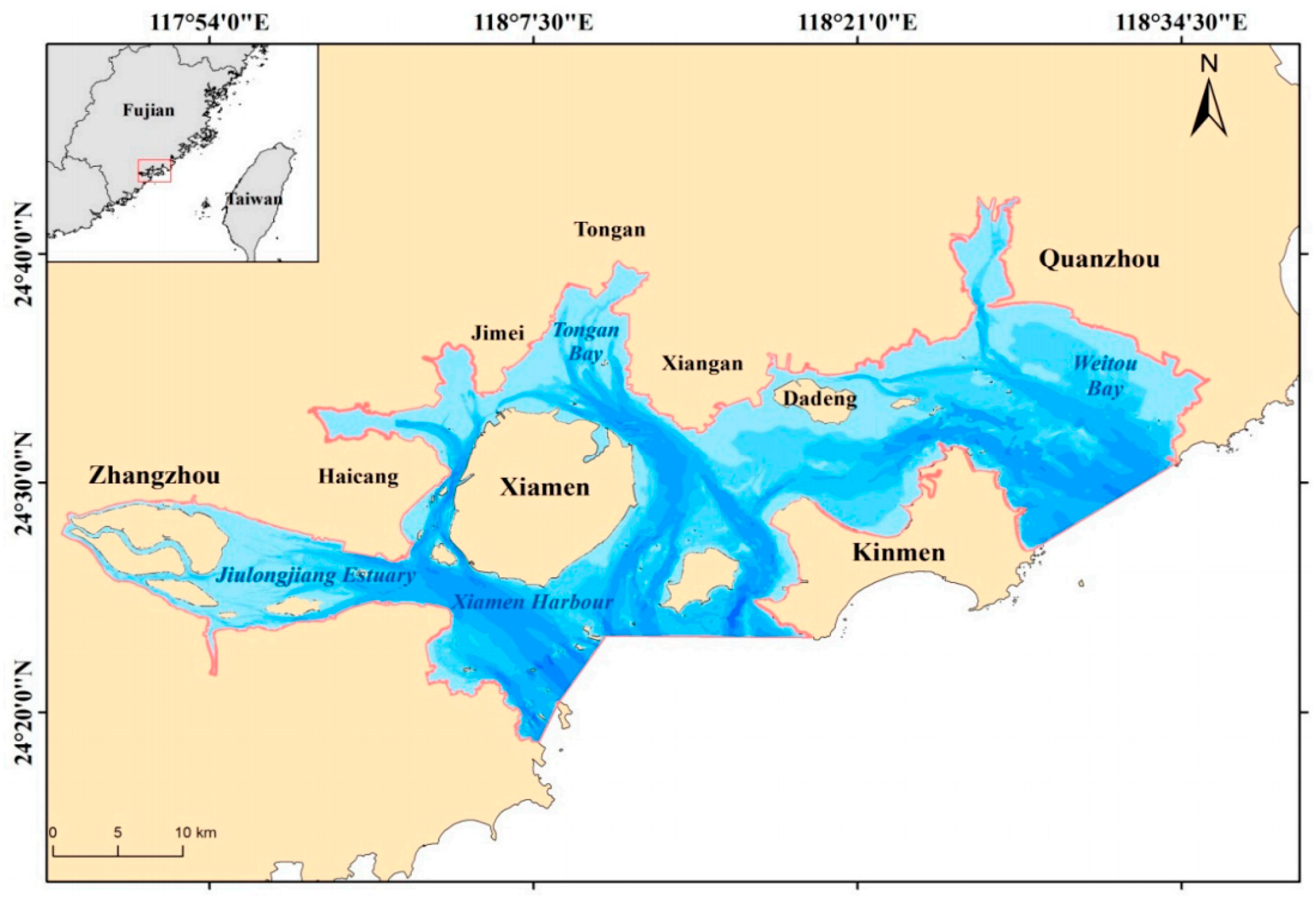
The sea area between Kinmen and Xiamen (as shown in Figure 1) off the southeast coast of China is surrounded by Xiamen, Zhangzhou, Quanzhou, and Kinmen. Residents in those four cities highly depend on the sea area for the co-use of marine resources. Stakeholders associated with this sea area comprise of fishermen, tourists who partake in water activities, transport operators, staff and passengers on liners, marine conservation teams, and law enforcement agents from Xiamen, Zhangzhou, and Quanzhou (China) and from Kinmen (Taiwan, China). However, without consultation or consent between the governments on both sides of the Taiwan Strait, the exploitation of sea sand by ships may have caused many long-term problems in the waters between Kinmen and Xiamen. It causes conflicts among stakeholders. Moreover, it has negatively impacted socio-economic diversity, including fishery production, collapse of the coastline, marine pollution, and the security of maritime entertainment (the cities surrounding the sea area between Kinmen and Xiamen include Kinmen, Xiamen, Zhangzhou, and Quanzhou. Kinmen and its sea area are under the jurisdiction of the Republic of China; therefore, Chinese citizens and ships are not entitled to enter or exit Kinmen’s territorial sea to engage in any fishery, industrial, or business activities without permission from R.O.C.). Fortunately, the implementation of MSP can support the socio-economic diversity of the sea area [6].
Thus far, MSP has not been implemented in a cross-city or cross-border management mode for any sea areas adjacent to China and Taiwan. Although the sea area between Kinmen and Xiamen is jointly used by residents of Kinmen, Xiamen, Zhangzhou, and Quanzhou, it belongs to China and Taiwan. Since this sea area is surrounded by four cities, problems concerning it must be solved jointly by four municipal governments and their citizens, so that conflicts among all stakeholders can be minimized. Through data collection, analysis, in-depth interviews, and an expert opinion survey, this study was expected to build an ecosystem-based management mode, i.e., a mechanism for Kinmen, Xiamen, Zhangzhou, and Quanzhou to jointly manage the sea area between Kinmen and Xiamen. It provides practical strategies for MSP to sustainably use marine resources, and couple social, economic, and ecological effects together to mitigate conflicts among stakeholders and further achieve the goal of socio-economic diversity. It was believed that, by presenting this study, activities that are harmful to the sea area between Kinmen and Xiamen can be effectively managed and marine ecosystems and maritime security can be jointly maintained to protect the surrounding landscapes and landforms.
The objective of this study was to resolve conflicts among stakeholders associated with the sea area between Kinmen and Xiamen by the application of MSP and support their sustainable use of this sea area. In this way, the diverse use and value of this sea area can be achieved. Explicitly, this study was engaged with the following: (1) analysis of how ocean currents, monsoons, tides and sand mining destroy the coastline of Kinmen and the sea area between Kinmen and Xiamen, (2) analysis of how, without consultation or authorization from the governments of both sides of the Taiwan Strait, sand mining impacts maritime security in the sea area between Kinmen and Xiamen, (3) analysis of how laws are enforced in the sea area between Kinmen and Xiamen, and (4) the establishment of a sustainability mechanism for Kinmen, Xiamen, Zhangzhou, and Quanzhou to jointly manage the sea area between Kinmen and Xiamen.

2. Materials and Methods

This study involved two steps, including the research content and the methods applied.

2.1. Problem Overview of This Study Area

The study area is the sea area between Kinmen and Xiamen, off the southeast coast of China, covering an area of 1676 km2 (as shown in Figure 2), and part of it is under the jurisdiction of the Coast Guard Administration (CGA), Taiwan, with an area of 838 km2 [17]. Prior to the date (2 January 2001) of implementing the “Mini-Three-Links” transportation between Taiwan and China, each government and people used half the sea area between them. Residents on both sides did not interact, as a consequence, there was no conflict among stakeholders who used the sea area. As China becomes more open and economically prosperous, conflicts will rise among stakeholders associated with the Taiwan strait. For example, fishermen of both straits sometimes contend with each other for fishing grounds. Without consultation and joint governance between the two governments, excessive fishing has led to the depletion of fishery resources. It affects the livelihoods of fishermen around the Kinmen–Xiamen waters. In addition, when there is more cargo and passenger ships in the area, there is less space available for people to engage in other water activities. The development of Xiamen has driven the demand for sand. Due to the limited supply of sand, in recent years, many ships have gone to the Kinmen waters to mine sand without the authorization of the government. Although law enforcement units on both sides of the Taiwan Strait have been trying to banish illegal fishermen, it has been ineffective owing to the features of the sea area between Kinmen and Xiamen: the daily tidal range is about 5 m, the intertidal zone can be 1 nautical mile long, and the navigable waterway along the northern coast of Kinmen is only 2 m deep, which is bad for patrol boats [17]. Due to long-term anthropic or natural factors, the coastline of Kinmen has receded and its landforms have changed (see Figure 3). In addition to affecting the fish-farming industry, the ocean has been polluted, and the habitat of protected fish, Horseshoe crab and Sousa chinensis, has been destroyed; unauthorized fishing also reduces the ability of law enforcement agencies on both sides to crack down on other illegal matters, such as illegal-sand-mining activities. Fishing activities and sand-mining activities without the authorization of the governments on both sides of the strait often violate the navigation rules by evading investigation, such as breaking into the “Mini-Three-Links” waterway, which affects navigation safety. Moreover, the over-exploitation of sea sand has also changed submarine hydrological conditions [18].

2.2. Conception of Applying MSP to Solve the Illegal-Sand-Mining Issue in Kinmen–Xiamen Waters

The prevention of conflicts among stakeholders associated with the sea area between Kinmen and Xiamen requires cooperation between China and Taiwan to execute the MSP management mechanism. The sustainability plan is drafted based on the facts that Kinmen, Xiamen, Zhangzhou, and Quanzhou surround the same sea area, and fishermen of those four cities, passengers, and marine resource users jointly use this sea area. To effectively resolve conflicts among all stakeholders, all law enforcement units involved in fishery administration, transportation, construction, and environmental protection should be incorporated into the scope of the MSP, whether they are from Kinmen, Xiamen, Zhangzhou, or Quanzhou. The MSP should be jointly managed by fishermen, marine resource users, and thalassophiles from the standpoint of protecting and maintaining marine ecosystems. The above issues must be jointly managed by stakeholders from the four cities through the implementation of an MSP and interaction and cooperation between Taiwan and China. Indeed, without cooperation of the governments on both sides of the strait in the cross-border Kinmen and Xiamen, it is impossible to curb relevant activities in the waters not authorized by the government, such as fishing or sand mining that is not authorized by the government. The local governments on both sides of the strait are independent, which makes the stakeholders’ interests conflict with each other under the fragmented management of this sea area. It causes damage to the marine environment and ecology. Therefore, from the theoretical meaning of MSP and the existing practice cases around the world, the Kinmen–Xiamen sea area is an ideal study area for MSP. From the application of MSP, all stakeholders can engage in sustainable use, diversification, and valuing the sea.
In summary, this study has explored how MSP could be applicable to establish the management mechanism of the Kinmen–Xiamen waters for the four local governments on the two sides of the strait, in order to completely solve the issues faced by the Kinmen and Xiamen waters.

2.3. Literature Analysis and Information Collection

This study utilized literature analysis, field study, in-depth interviews, and expert opinion survey to explore issues arising from governance in the Kinmen and Xiamen waters and further proposed sustainability strategies for MSP.

2.3.1. Literature Analysis

Firstly, through document analysis, the relationship between Kinmen’s coastline retreat and anthropic or natural factors were noticed. There is a question that arose: are there any problems for Kinmen’s coast guard in the enforcement of laws in the sea area between Kinmen and Xiamen? Hence, this study focuses on the influence of illegal sand mining on the sea area between Kinmen and Xiamen and on Kinmen’s territory. Three aspects of the study and their relationships were initially stressed: “the influence of natural factors such as ocean currents, tides and typhoons, and the impact of anthropic factors such as illegal sand mining on land erosion and landform changes”, “the difficulties in law enforcement in the sea area between Kinmen and Xiamen and the enhancement of law enforcement capacity”, and “a mechanism for Kinmen, Xiamen, Zhangzhou, and Quanzhou to jointly manage the sea area between Kinmen and Xiamen”. The goal was to minimize negative impacts on the sea area between Kinmen and Xiamen by implementing MSP. The relevant content of literature review of this study is illustrated below.

The Relationship between Kinmen’s Coastline Retreat and the Natural and Anthropic Factors

Some scholars revealed that natural and anthropic factors are the major reasons for coastline retreat. Natural factors include: strikes from waves and storm surges caused by typhoons [19]; long-time destructive processes from the northeast monsoon waves and tidal current [20]; interdiction by natural terrains, such as a submarine canyon at the estuary of Gaoping River, and drifting sand. Anthropic factors include: excessive extraction of groundwater in coastal areas; aquaculture [21,22,23]; and river and coastal construction such as mole jetty, bank protection, and weir [24]. Chang [25] and Chang et al. [19] found the destruction of landscapes, misuse of wave breakers, blocking of drifting sand by big coastal structures, poor soil and water conservation measures in mountain regions, the construction of artificial reservoirs and weirs, excessive river sand and gravel mining, and excessive or illegal use or development of lands in coastal areas. In much research, it was discovered that there were natural factors causing the impacts on Kinmen’s coastline, but natural sedimentation has been counterbalanced by erosion for a long time, which has led to a stable equilibrium state [26]. Although coastal landscapes changed in Kinmen because a causewayed lake and Shuitou Commercial Port were built near Guningtou, the results of Lin’s research [26] showed that seabed topographical changes in the sea area of Kinmen were counterbalanced before 2006. Another fact is that there are no large rivers in Kinmen, so the volume of river sand is not high enough to change seabed topography in the sea area of Kinmen. Even though there is an artificial reservoir downstream of a river, it has no impact on the seabed topography [27]. Neither large river and coastal construction nor large-scale BOT projects have been built along Kinmen’s coast. The Water Resources Agency, Taiwan [27] testified, in the “Field Study on Coastal Monitoring and Investigation in Kinmen”, that, in the three monitored areas, the factors responsible for coastal erosion areas may be erosion and sedimentation, typhoon strikes and excessive sea-sand mining. In another study conducted by Kinmen National Park Headquarters and Water Resources Agency, the results showed that there might be other possible factors in Kinmen’s coastal erosion. However, excessive extraction of sea sand should be a possible factor, which also brought damage to the living environment for some rare fish such as lancelets and Sousa chinensis, and to oyster farming [28].

Exploration the Factors of Sand Mining in Kinmen and Xiamen Waters

The main reason for vessels mining sand is that Kinmen’s sea sand has high economic value [29]. It is a challenge for Taiwan’s coast guard to enforce laws there. It only takes a few minutes for vessels to exit from the restricted waters of Kinmen (prohibited and restricted waters—a term originating from Taiwan’s regulations: Vessels from mainland China area are not allowed to enter the territorial sea (prohibited waters—12 nautical miles) and adjacent waters (restricted waters—24 nautical miles) in the Taiwan area without prior permission. For the reason that Kinmen is very close to Xiamen, the Ministry of National Defense, R.O.C. especially announced prohibited and restricted water areas that are applicable to the Kinmen waters). In addition, during fog season, poor visibility serves as cover for vessels’ unlawful activities; both above factors make evidence searching and the banning of ships difficult for law enforcement units. Moreover, sand-mining ships usually work collaboratively. When a Taiwanese patrol boat is seen, sand miners use a radio communication system to alert one another to reduce the risk of being caught. Land reclamation in China requires a great deal of sea sand, so people are willing to take risks by mining sand unlawfully [30]. Researchers have also found that the popular sand-mining areas among vessels are the northeastern Leiyu Island and the northwestern and the northeastern Greater Kinmen Island. Popular sand-mining areas may be different depending on sea sand volume [31].

Taiwan’s Coast Guard Has Difficulties in Law Enforcement Capacity in the Sea Area between Kinmen and Xiamen

From in-depth interviews with Kinmen coast guard and the research of Kao et al. [18], the reasons why Kinmen coast guard has difficulty in law-enforcement capacity include insufficient on-duty equipment, manpower, and cooperation between Taiwan and China to fight crime. How can the CGA of Taiwan overcome the current predicament and work with China to fight crime? This study aimed to design practical strategies through interviews with law enforcement agents from both Taiwan and China. Regarding the sea area between Kinmen and Xiamen, it clarifies the causes of predicament, and explores how Taiwan and China can improve their capacity for maritime law enforcement.

The Meaning and Importance of Implementing MSP for the Sea Area between Kinmen and Xiamen

In view of the fact that Kinmen, Xiamen, Zhangzhou, and Quanzhou belong to the same sea area, the Taiwanese and Chinese governments should enforce laws collaboratively for effective management and prevention of illicit maritime activities and environmental issues.
Recently, with increasing maritime development and marine environmental protection business, people have tended to use MSP as a management tool to resolve the conflicts of marine use and carry out strategies that are the most compatible among all maritime activities. MSP has been rapidly developed and is becoming a global focus [32]. MSP is an ecosystem-based, interdisciplinary management approach that is designed to make people comprehend the relevance, integrity, and biodiversity of ecosystems in a scientific way. It integrates dynamic features of ecosystems aiming at the marine ecosystem, but with an administrative scope. Its management objective is to achieve the goal of sustainable use of marine resources. It is also a management system that combines social, economic, and ecological effects together in order to address them [9]. Specifically, MSP is a process that entails allocating spatial and temporal distribution of human activities in marine areas, such as marine reserves, maritime transportation, renewable energy, sea-sand mining, fishery, culture, oil and gas extraction, and military defense [1].
Since MSP contributes to the coordination among all users in the process of using marine waters, the implementation of MSP depends on all stakeholders’ interests, impressions, opportunities, management opinions, and expectations of the scheme [31]. When making a marine plan, any person, group, authority, or organization interested in MSP or subject to the managed areas of the plan can be defined as a stakeholder. Besides, local governments or relevant authorities need to improve their knowledge in marine planning and participate in the process. It is their responsibility and obligation to care about local interests and development because it is their area’s representatives that contribute [33]. Gilliland and Laffoley [34] reported that, in terms of managing authority, an authority that deals with environmental issues is in the best position to set up and carry out an MSP. As far as other parties are concerned, the most important thing is to allocate and invest in job duties and resources for effective implementation of MSP. Ehler and Douvere [3] stated that most countries have designated and divided marine space for human activities in the ocean, such as maritime transportation, oil and gas extraction, renewable energy in coastal waters, inshore aquaculture, and ocean dumping. Ehler and Douvere [3] believed that MSP is a public process of analyzing and allocating the spatial and temporal distribution of human activities in marine areas to achieve ecological, economic, and social objectives that are usually specified through a political process. MSP is a continuous process that should be constantly learned and adapted.
From the experiences and challenges of MSP practice, Ehler [35] concluded the following: (1) legal authority and political support for MSP are important factors for success; (2) MSP is a continuing and repeatedly adaptive process that includes survey and study, analysis and planning, financial support, practice, monitoring, and evaluation; (3) sound information base, comprising both natural and social science information, is critical; (4) MSP is an important function of ecosystem-based sea-use management; (5) stakeholders must be empowered to participate effectively throughout the MSP process because early and continuing engagement of stakeholders is critical to success; (6) monitoring, reporting, and evaluation are critical functions that allow MSP to adapt to changing conditions; (7) MSP should be integrated with plans for adjoining coastal areas, with terrestrial land-use plans, and with coastal watershed (catchment) plans; (8) guidelines for ecosystem-based marine spatial management must be developed [36].

2.3.2. Information Analysis

This study conducted field study, in-depth interviews, and expert opinion surveys to obtain the information needed for this study.

Field Study

In addition to the literature analysis, this study also conducted observation and surveys in Kinmen–Xiamen waters. It was mainly to observe the possible crime scenes of illegal sand mining, and explore the impact of sand mining on the environmental damage, marine ecology, and maritime safety of the Kinmen Waters. This mainly included participating observation and environmental survey. Participating observation is to analyze the data of the existing literature for the hot areas of illegal sand mining and survey (observe) on-site. In addition, Kinmen’s fishermen, marine and geography experts, and local seniors were interviewed to understand the impact of illegal sand mining on the Kinmen–Xiamen waters. Besides, an environmental survey applied modern tools such as video recording, photographing, recording, surveying, and mapping to plot and record data in field surveys to increase the reliability of qualitative research.

In-Depth Interviews

To acquire more information of the research topic, this study interviewed officers who were experienced in marine law enforcement. It includes a supervisor in fishery and a supervisor in sea area development in Kinmen County, and 3 members of Offshore Flotilla, who are responsible for marine law enforcement and case investigation. To understand the view of mainland China, this study also interviewed 2 law enforcement officers in Xiamen and 1 marine-law scholar. The interviewees were asked to provide their actual observations and personal opinions on the law-enforcement situation of illegal sand mining, the current situation of cross-strait marine coordinated law enforcement against illegal sand mining, and the capabilities of law-enforcement efforts in the Kinmen–Xiamen waters. It helps to understand the current dilemmas involved in the current law enforcement from transboundary sand mining, and provides suggestions.
This study has applied one-to-one “semi-structured interviews”. The outline of the interview mainly included the current situation of illegal sand mining and its impact on the marine ecology and maritime safety of Kinmen. Moreover, it explored the overview of the law enforcement of the Coast Guard Administration, whether the capabilities of law enforcement are enough, what law enforcement dilemma is being faced and how to solve it. Furthermore, it addressed the legal issues involved in illegal sand mining, administrative procedures after banning, attaching the ships and the penalties, the current situation of cross-strait marine coordinated law enforcement against illegal sand mining, and the ways to cooperate with mainland China to solve the issues of illegal sand mining by ships. In addition, to obtain informed consent from the participants, the researchers explained the purpose and procedures of this study to the participants. The information was obtained based on the answers to the interview outline of voluntary respondents. The participants were assured that their responses were confidential and anonymous. Moreover, to make the interviewees understand the purpose of the interview and the actual meaning of the interview outline, it requires the interviewer to explain interview-related information and matters, and send the interview outline before the interview. This study has carried out in-depth interviews with the subjects, including the law-enforcement experts who were responsible for investigation of illegal sand mining in Kinmen area. They were rich in practical experience on this issue. Therefore, the information acquired from the interviews is representative and professional.

Expert Opinion Survey

In order to make the data collected more comprehensive and complete, two supervisors from cross-strait academic and practical units were invited for opinion surveys. There were 10 interviewees invited, including two professors in the field of marine affairs from Quemoy University and Xiamen University, respectively, and two law-enforcement supervisors from each of the following fields, including sea area, fishery administration and seas-area development. The information acquired from the opinion surveys Was applied as a guideline to investigate and plan future law enforcement against illegal sand mining, maintaining marine ecology, prevention of continuous coastline collapse, and different strategies of maritime safety. In addition, the management mechanism of Kinmen–Xiamen waters for cross-strait four local governments “Kinmen, Xiamen, Quanzhou and Zhangzhou” was drafted. These expert opinion surveys covered marine scholars and practical experts in Kinmen–Xiamen area and they have in-depth research or practical experience on this research topic. Therefore, their opinions expressed would be professional and representative.

3. Results

Since 2007, long-term natural factors such as ocean currents, tides and typhoons, as well as human factors such as the many coastal developments and the cross border for sand mining, have caused Kinmen’s coastal landforms to change and have damaged the marine ecosystems.

3.1. Natural and Anthropic Factors Have Resulted in Kinmen’s Coastline Retreat, Marine Environmental Damage, and Threats to Maritime Security

3.1.1. Analysis of How Natural and Anthropic Factors Caused Kinmen’s Coastline Retreat and Landform Changes

Research has shown that the main reason for coastal changes is the disequilibrium of sand supply and demand. Although there are natural factors in the impacts on Kinmen’s coastline, natural sedimentation has been counterbalanced by erosion for a long time, and this has resulted in a stable equilibrium state [26]. Another fact is that coastal landscapes in Kinmen were changed because a causewayed lake and Shuitou Commercial Port were built near Guningtou. The results of Lin’s research [26] showed that seabed topographical changes in the sea area of Kinmen were counterbalanced without being affected by the construction of Shuitou Commercial Port. According to the data of Kinmen National Park Headquarters [37], there are eight rivers with lengths from 1 to 8 km in Kinmen. Topography plays an important role in low flows and short river sources. There are 14 artificial reservoirs and 141 weirs built downstream. Due to the original low flows, the construction could not change the submarine topography in the sea area of Kinmen. Neither large river and coastal construction nor large-scale BOT projects have been built for Kinmen’s coast [38]. In addition, the Water Resources Agency in Taiwan conducted “Field Study on Coastal Monitoring and Investigation in Kinmen” in 2011. According to the corresponding report, both erosion and sedimentation have occurred in the three sections of the coastline. The possible causes of coastal erosion may include typhoon invasion, indiscriminate sea-sand mining by sand-pump dredgers, and the long-term indiscriminate sea = sand mining by local villagers to build the fortifications. That agency implemented the “Field Study on Coastal Monitoring and Investigation in Kinmen” in 2014. The report pointed out that the preliminary determination of the cause of coastal erosion should be related to human activities, including the illegal sand mining and the coastal-development projects. However, besides the extensive illegal sand mining by the sand pump dredgers, the Kinmen County Government stated that factors may also include climate change and coastal development. Moreover, to clarify the cause of the collapse of the Guningtou Beishan cliff and Leiyu Nanshantou coastline, the Kinmen National Park Headquarters invited scholars and experts for a site investigation from 25–26 December 2012. After the investigation, it has been verified that the collapse of two sections of the coastline would be an effect of natural weathering. However, the intensive sand mining by sand=pump dredgers would affect the ocean current, erosion, and deposition of the islands around the Xiamen Bay. It should be one of the important factors affecting coastline regression and accelerating the coastal geological changes. It appears that natural and anthropic factors have resulted in Kinmen’s coastline retreat and landform changes.

3.1.2. Analysis of How Anthropic Factors Damaged the Sea Area of Kinmen

Studies of the damage caused by illegal sand mining in the sea area between Kinmen and Xiamen have been conducted, and the results showed the following: (1) Marine ecosystems and fishery resources are damaged. The illegal extraction of sea sand from the seabed has impacted the habitat of the horseshoe crab. Owing to the horseshoe crab’s reproductive habits, they spend their entire life in intertidal zones, submarine sandstone beds, sandbars, and mudflats. Nevertheless, their living space has been destroyed by illegal sand mining, which has jeopardized their subsistence [18]. The living space of Sousa chinensis is also constricted by a ruined habitat, noises, and the direct discharge of wastewater due to illegal sand mining. Furthermore, according to the Investigation of Chinese White Dolphin in Kinmen waters in 2011, the noise of sand-pump dredgers, and the frequent and fast ferries in the Kinmen and Lieyu channels after mini three links could possibly affect the activities of the dolphins, and make the Chinese white dolphin avoid activities in this sea area and move to other sea areas nearby. Scholars and experts also suggested measuring the noise of the sand-pump dredger to assess the ecological impact on the white dolphins. In addition, there would be less and less space for benthic flora and fauna to live, reproduce, and hide because sand-mining ships extracted sand from the sandy seabed until it became a trench. Consequently, the absence of a sandy seabed, which served as habitat for shrimps and shellfishes, has directly endangered benthic flora and fauna, and has led to the extinction and death of benthic flora and fauna. (2) The mortality rate of oysters is higher than before in Kinmen. Since 2014, a big number of oysters have suddenly died in Kinmen. Investigation results suggested that, when illegal sand mining extracted sand and gravel from the seabed, deep-sea mud drifted and attached to the stakes that were used for rock-oyster farming; as a result, humus thickened and generated poisonous gases, which caused the sudden death of a great many oysters [18]. After deep-sea mud drifted owing to sea mining and attached to oyster stakes, the mud buried the stakes that were originally 1 m above sea level, and left the stakes only 50 cm to grow oysters (as seen in Figure 4). The number of oysters that could be harvested decreased, which affected the livelihood of oyster farmers.

3.1.3. Analysis of How Anthropic Factors Impacted on the Maritime Security of Kinmen

Researchers have reported that illegal sand mining leads to coastal erosion in Kinmen. It can result in ocean current shifts or fluid erosion, and, as a consequence, the submarine topography has been destroyed. It also threatens navigational safety. The intrusion of sand-mining ships can threaten the security of maritime routes and ocean pollution. Given the close distance and narrow sea area between Kinmen and Xiamen, the number of relevant stakeholders who use the sea area has almost reached maximum capacity. They not only pose a threat to maritime safety but also lead to vessels’ anchoring, grounding, or collision in environmentally sensitive areas, thereby further causing pollution and damage to the marine environment.
The width of the Kinmen–Xiamen waters is only just more than 10 km. Before the suspension of shipping service of mini three links due to COVID-19, there were around 20 ships sailing to and from Kinmen and Xiamen everyday (one round trip for each 30 min). In addition, there are cargo ships for mini three links (still in service), the activities of fishing boats and people in these waters, and illegal sand mining by ships causing the changes in the hydrological data of the sea, which may affect maritime safety. A maritime accident may also occur due to the ships arbitrarily entering or leaving the channel when they are evading investigation or are driven away by the Taiwan Coast Guard Administration. This would be the main anthropic factor affecting the maritime safety of Kinmen.

3.2. Analysis of Current Status of Illegal Sand Mining in the Sea Area between Kinmen and Xiamen and Crime Characteristics

3.2.1. Current Status of Law Enforcement Coordination between Taiwan and China

The scope of people-to-people communication, political exchanges, and economic cooperation between Taiwan and China has been extending continuously since 2008. In 2009, with the support of and instructions from China Marine Surveillance (CMS) toward the goal of harmonious and stable relations between Taiwan and China, the Fujian Province CMS, the Xiamen City CMS, and the Fuzhou City CMS worked with CGA, Taiwan to set up a communication platform for irregularly collaborative law enforcement in the sea area between Taiwan and China [18]. After the initial collaborative marine law enforcement in 2009, the Fujian Province CMS and CGA, Taiwan created a contact window for mutual marine law enforcement in 2010. By the year 2015, collaborative marine law enforcement between Taiwan and China had been practiced 19 times, and 56 illegal-sand-mining ships that caused damage to the marine environment had been seized. Taiwan and China cooperated with each other to exchange information on unlawful activities, find evidence, and bring lawbreakers to justice for the protection of marine ecosystems and navigational safety [39]. Up to the present, the constant release of fish fry in the sea area between Taiwan and China has positively impacted and protected marine life. As regards the mechanism for enforcing laws against unlawful activities in the sea area between Kinmen and Xiamen, such as illegal electrofishing, blast fishing, and sand mining, the Oceans and Fishery Bureau of Xiamen and the Kinmen coast guard initiated a mechanism for fast cooperation on law enforcement to instantly communicate and work with each other to fight crime and protect marine resources in the sea area between Kinmen and Xiamen [40]. The Xiamen Municipal Bureau of Ocean Development released news on 30 September 2018 about the law enforcement status in the sea area of Xiamen. It mentioned that the marine patrol units of China should actively develop a sound and complete mechanism for collaborative law enforcement between Kinmen and Xiamen, to normalize cooperation, share information in a timely manner, remove illegal fishing gear from sea borders, and sequestrate ships that illegally cross the border [41].
In summary, the sea area between Kinmen and Xiamen requires the four cities of Taiwan and China to collaboratively enforce laws. It is also a common goal that law enforcement units of Taiwan and China work toward. It is not only important but necessary for Taiwan and China to establish a managing mechanism for MSP in the sea area between Kinmen and Xiamen.

3.2.2. Case Study of Illegal Sand Mining in the Sea Area between Kinmen and Xiamen

Table 1 presents the performance of the illegal-sand-mining-ship intrusions captured by the CGA from 2005 to 2018 in the sea area of Kinmen. The number of ships captured by Taiwan’s CGA in Kinmen, Matsu, and Penghu from 2019 to October 2020 and the proceeds from the auctions of ships are shown, and the analysis is as follows:
Table 1 shows that the sand-mining areas popular among vessels are in the northeastern Leiyu Island and the northwestern and northeastern Greater Kinmen Island (as shown in Figure 5). The number of lawbreakers captured was around five to eight people per ship. The methods mainly used by illegal sand-mining ships include: (1) during fog season, low visibility serves as a cover for vessels’ unlawful activities; (2) at nighttime, someone from each ship was designated to be the watchdog and they all act discreetly; (3) when facing an investigation, staff on the ship refused to drive the ship and deliberately caused the ship to malfunction to hinder law enforcement; (4) ships zigzagged to avoid patrol boats; (5) sharp iron bars were hung on each side of the ships to harm investigation officers who tried to embark on the ships or to distance itself from patrol boats. The pattern of Taiwanese CGA’s law enforcement and the Kinmen coast guard usually includes single-hull or double-hull boats to flank lawbreaking ships or utilizing rubber rafts and fishery conservation team boats to fight crime. Unfortunately, without China’s collaboration, Kinmen coast guard’s investigation is often ineffective.

3.3. Field Study, In-Depth Interviews, Expert Onion Survey

3.3.1. Field Study

To collect relevant information, this study implemented field surveys to understand the actual situation of the Kinmen coastline retreat and the damage of marine ecology. Our research team visited the site several times and found that the coastline has regressed as shown in Figure 3, Figure 4 and Figure 6a,b. For example, the military bunker has collapsed due to the collapse of coastline, and the bollards on the shore for the naval ships have almost been flooded by the sea due to the coastline retreat. In addition, the bottom of a bollard for navy landing boat’s supply operation is exposed and a street lamp pole has collapsed. Moreover, when the research team took photos somewhere in Kinmen, it was found that the huge rocks for the stabilization of sand have been washed out continuously. The research team also interviewed some local people: fishermen or seniors, randomly. The team was told that navigating along the coasts should be performed carefully due to the regression of the coastline. The ships sailing around some coastal waters could easily be stranded. A local conservationist who has been concerned about the marine ecology of Kinmen for long time pointed out that illegal sand mining would change the topography of the seabed and ocean currents. The corresponding situation may mean it becomes impossible to breed phytoplankton and zooplankton. Another senior mentioned that the sea sand in the sea has been exhausted by many natural factors, and the pump dredgers. Since the sand on the beaches would naturally compensate the hollows, the sand on beaches moves outward. After certain period, the sand on beaches would disappear.
In summary, the research team acquired a lot of valuable information through the field inspection, visit, observation and photographing of the environment and random interviews. In addition to verifying the information in the literature, many valuable photos, opinions, and the actual experiences of local people were received. Many natural and anthropic factors of the past 10 years are one of the factors causing the regression of the Kinmen coastline, damage of marine ecology and impact of maritime safety.

3.3.2. In-Depth Interviews

This study acquired the following information through in-depth interviews:
In this study, the enforcers of marine law in Kinmen were interviewed. The results of the interviews indicated that the difficulties that the Kinmen coast guard have regarding law enforcement capacity are: (1) insufficient ship capacity; (2) complicated marine topography and limited law-enforcement area (only in the sea area of Kinmen); and (3) a radar-blind zone and insufficient synergy capacity. Illegal sand mining has drawn the attention of Taiwanese CGA officers. This is because the above difficulties may endanger law-enforcement agents. For instance, if a large iron-hulled ship tries to resist investigation, it may harm Kinmen’s law enforcement agents.
Interviewees believed that marine law enforcement involves a wide range of space, but when the Kinmen coast guard cannot cross the border to ban illegal sand mining due to the restricted law enforcement area, the enforcement action fails easily unless there is collaborative law enforcement action. Many experts contributed their opinions to this study; they included scholars from the National Quemoy University, officers of the adjudication authority in Kinmen, and marine-law enforcers from Kinmen. The main opinions are: The sea area of Kinmen is close to China, and there is insufficient border patrol manpower, boats, and equipment. There should be official dialogues and communication between Taiwan and China. The Kinmen fishing ground is one of the best fishing grounds on the southeastern coast of China. However, many natural and anthropic factors have destroyed the marine ecosystems. If Taiwan and China can enforce laws collaboratively, it will produce good enforcement results. The sea area of Kinmen is narrow, the patrol area is constricted, and many sunken reefs are on the northern side. Accordingly, there is not much space for hot pursuit and coast guard’s law enforcement. If the law-enforcement units of both nations can cooperate with each other, crime fighting will become easier. One more problem is that a marine ecological destroyer cannot be arrested unless they are caught in the act. Hence, it is necessary that local governments work with central governments, and that Taiwan works with China. Without collaboration, it is difficult for law-enforcement units from either Kinmen or Xiamen to arrest lawbreakers.
One of the interviewees mentioned that the existing management unit for illegal sand mining would be the Economic Affairs Department, while the law-enforcement agency would be Coast Guard Administration. To encourage the Offshore Flotilla to enhance investigation, the county government has established an incentive. Rewards would be provided for each illegal ship captured. In addition, the corresponding cross-strait units should negotiate about the scope of the sea area and the situation of illegal sand mining. Since the sea area of the Kinmen Waters is small, it is often ambiguous whether the sand pump dredger crosses the border or not. However, Kinmen County Government belongs to the local government level and is not authorized to cooperate with mainland China directly. This would rely on the cross-strait central governments for negotiation, or authorizing local governments to cooperate in law enforcement affairs. Moreover, some interviewees mentioned the regression of the Kinmen coastline. In addition to illegal sand mining, many natural factors and the coastal development might be main reasons. However, Taiwan should be able to provide more scientific evidence, such as actively investigating the illegal activities of the ships in order to encourage mainland China’s goodwill. It is also believed that the regression of the Kinmen coastline would include the following factors: (1) the amount of sand entering the sea from Jiulong River Estuary has decreased; (2) climate and ocean current change; and (3) illegal sand mining.
Interviewees also pointed out that many natural and anthropic factors have caused the following harm or damage to the marine ecology: (1) The sandbanks of Lieyu have been eroded and the habitat of the Eleutheronema tetradactylum has been destroyed; (2) oysters have been affected greatly by anthropic factors. There are around a thousand oyster farmers in Kinmen. Since the oyster bamboo rafts are covered by mud, oysters cannot breathe or die; (3) the precious shrimp species on the north coast of Kinmen may be affected; (4) the regression of the coastline causes the loss of territory; (5) our side should engage in research actively to explore all the possible causes of the loss of territory. At present, it is focused on remedial methods, such as protecting the coasts. In general, the remediation is performed by placing wave-breaking blocks, but this may change the ocean currents. Therefore, scientific verification of the effectiveness is necessary; (6) the law enforcement units of the Zhangzhou and Quanzhou’ sea area should be jointly included in the scope of the Kinmen–Xiamen waters coordinated law enforcement. The remediation of the marine environment in the Kinmen–Xiamen waters involves the cross-border governance of Kinmen, Xiamen, Zhangzhou, and Quanzhou. The local governments of those four cities, and the corresponding law enforcement units should treat this sea area as a whole area to break the restriction of administrative regions and jointly govern different issues of the Kinmen–Xiamen waters, including illegal sand mining and many anthropic sabotages.
In this study, the scholars from Xiamen University and the law enforcers from Xiamen were also interviewed. They confirmed that: (1) Law enforcement capacity in the sea area between Kinmen and Xiamen is insufficient; there should be a unified operations center to integrate manpower from all relevant units and deploy tasks. Although there are many marine law enforcement units in Xiamen, their enforcement powers are weakened because their strengths have not been well organized; (2) each central government from both nations should delegate decision-making power to local governments because local governments are more aware of local affairs; (3) a great MSP mechanism should be established to include Kinmen, Xiamen, Zhangzhou, and Quanzhou. Central or provincial governments should loosen regulations and allow local governments to exercise power. The sea area between Kinmen and Xiamen is jointly used by residents of those four cities. It implies that most of the criminals are from those four cities; in addition, in view of the vast sea area, the power of all governments and law enforcement units should be integrated to fight crime collaboratively.
In summary, this study conducted eight in-depth interviews. The interviewees were mainly the cross-strait law enforcement officers in the Kinmen–Xiamen waters, and put forward many opinions on the dilemma of marine law enforcement, the factors influencing the collapse of the Kinmen coastline, and cross-strait coordinated law enforcement. Those personnel included experienced officers of marine law enforcement, business supervisors, and marine-law experts. The information acquired from interviews has come from the experience and academic insights of the interviewees. Their opinions have been consistent with the existing literature. There is no sign of prejudice or an improper effect on the research results. They have also enriched the information of this study.

3.3.3. Expert Opinion Survey

This study interviewed 10 cross-strait experts on marine and the Kinmen–Xiamen waters law enforcement. It includes two professors or researchers from Xiamen University, and two law enforcement officers in Xiamen waters.
Interviewees mentioned that the capabilities of law enforcement in the Kinmen–Xiamen waters are insufficient. The cross-strait governments should establish their own single command system to integrate manpower and dispatch duties to each unit. The local-level law-enforcement units or marine-management units could implement diverse approaches with a command mechanism on top. The local government knows the local affairs well, while central level may not understand clear. Therefore, the cross-strait central governments should give the decision-making power to the local governments so that they could fully manage themselves. For example, during the typhoon Meranti, a cargo ship “Gang Tai Tai Zhou” from mainland China ran aground in the Gugang Waters of Kinmen for two months. It was caused by the insufficient communication mechanism between two sides. If the decision-making power related to the cross-strait Kinmen and Xiamen affairs at the local level could be given to local governments, it is believed that the cargo-ship-stranding problem could be solved very soon. Lastly, the interviewees believed that mainland China should enhance law enforcement measures for the management of sand carriers. That means the coast guard, border defense force and other marine units jointly ban the illegal-sand-pump dredgers in accordance with the law, and investigate and punish the illegal-sand-mining activity, and increase the administrative penalty and compulsory efforts to increase the cost of illegal sand mining.
In addition, the interviewees had the following opinions regarding the establishment of the MSP in the Kinmen–Xiamen waters:
Both governments must establish a cooperation mechanism for the sea area between Kinmen and Xiamen to ensure the rights and interests of stakeholders. It must start with cooperative law enforcement and management to carry out the functionality of the MSP. The illegal-sand-mining problem in the sea area between Kinmen and Xiamen requires an MSP-based joint management mechanism. Therefore, the components of MSP for the sea area should include the determination of the scope of spatial planning, investigation, and analysis of current conditions of the sea area, a scenario analysis of the spatial planning, participation of stakeholders, and research into hot issues (such as the protection of rare-marine life, cross-border fishing, and sand mining). The goal is to establish a database for the analysis of popularized spatial planning. Currently, there are political issues between Taiwan and China. If scholars from the Kinmen County government and maritime administrations of Xiamen, Zhangzhou, and Quanzhou can participate together in the establishment of an MSP leading group by analysis, planning, adjustment, and the process of continuous updates in the future, there are still ways to resolve and cope with conflicts among stakeholders and Kinmen’s coastal landform changes.

4. Discussion

This study utilized a literature review, data collection, field study, and in-depth interviews with law enforcers in the sea area between Kinmen and Xiamen, stakeholders, Chinese and Taiwanese scholars. It found that:

4.1. Many Natural and Anthropic Factors Have Caused Kinmen’s Coastline Retreat and Landform Changes

The land of Kinmen is eroded and washed out in summer but silted up in winter, except the northern coast [
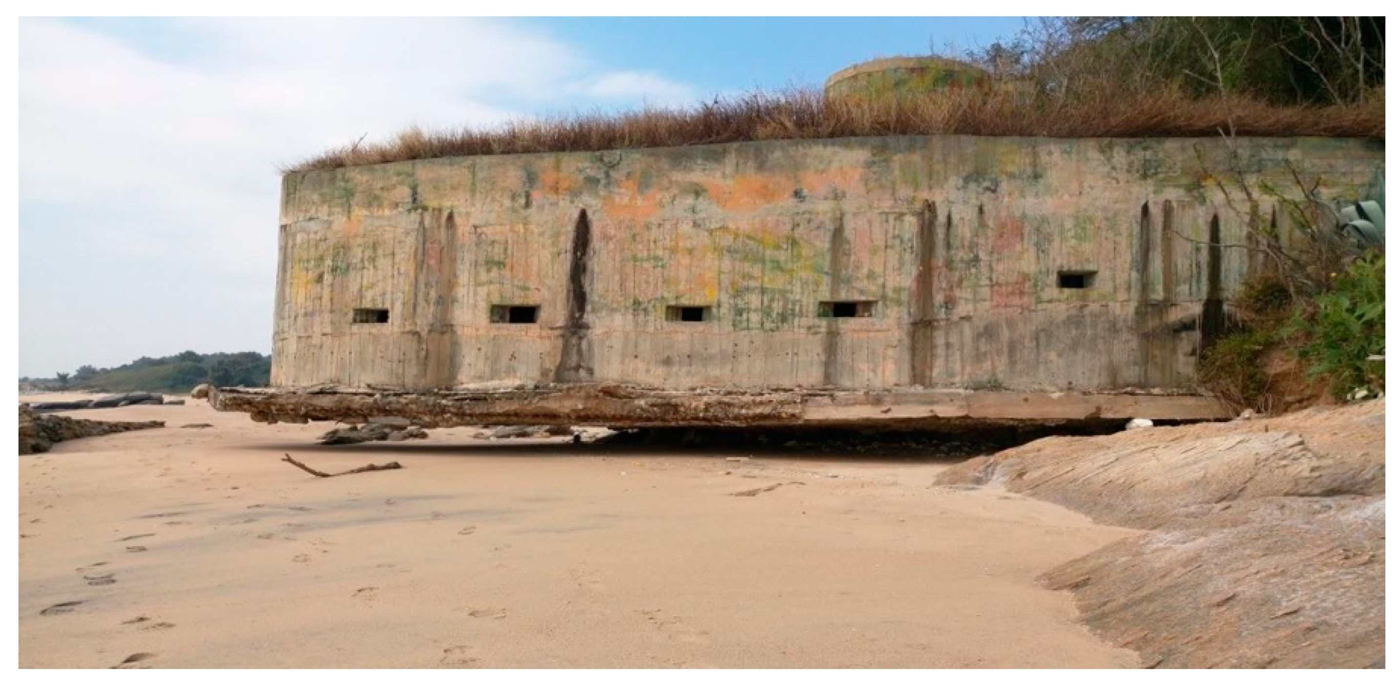
26]. Studies have indicated that the remaining eroded areas are mainly from long-term natural factors, such as ocean currents, tides and typhoons, and the anthropic factors of illegal sand mining and coastal development. Kinmen is a small island without high mountains or long rivers to bring abundant sand sources. Consequently, without collaboration to stop the disorganized development of the coast and illegal sand mining in the sea area between Kinmen and Xiamen, the coast of Kinmen would unceasingly retreat, and even the embankment could not protect the coastal landscape or prevent coastal retreat. The evidence is that the natural and anthropic factors have not only impacted the existential security of Kinmen citizens but have resulted in seawater intrusion, soil salinization, landform changes, coastal retreat, and erosion as well. For example, the coastline at Xintou of the Jinhu Township has collapsed and been eroded. It resulted in the bottom of bollard for navy landing boat’s supply operation being exposed and street lamp pole collapsing (see Figure 6a,b).

4.2. The Difficulty in Law Enforcement in the Sea Area between Kinmen and Xiamen

The mutual legal assistance between Taiwan and China concerning subject hierarchy and differences in power allocation and in criminal evidence are the primary problems in the collaborative collection of evidence for criminal investigation. Evidence collection for criminal investigation belongs to different units. In Taiwan, prosecutors are the only investigation subject. In China, criminal investigation is subject to the authority of public security [43]. If law enforcers want to ban illegal sand mining based on the mechanism of fighting crime collaboratively by Taiwan and China, the differences in collecting evidence for criminal investigation will still make it difficult to happen (Hsu, 2016). In another aspect, the sea area of Kinmen seems to be a haven for illegal-sand-mining ships. When a coastal-surveillance radar detects an illegal-sand-mining suspect in the sea area, and Kinmen’s patrol boat gets close to the specific area, the China-owned ship quickly returns to the sea area of Xiamen. This is what makes maritime law enforcement laborious. In addition, the legal consequences are not serious enough to deter unscrupulous people. When an illegal sand mining ship is seized by Taiwan, it is fined TWD 3 million, and the ship and staff are detained for two months. Apparently, this penalty has not deterred people from illegal sand mining. Constrained by cooperation from China, the frequency of cross-strait collaborative law enforcement is not high enough. From 2009 to 2016, the number of the collaborative enforcement cases was 20 in seven years, with an average of 3 to 4 each year, and a total of six vessels were seized. Considering environmental damages, impacts on navigational safety and economic interest, there is still wiggle room for enhancing penalty and collaborative-enforcement frequency. To solve the above problems, the Taiwanese government should make legitimate regulations on the issue of vessels’ illegal sand mining, enhance law-enforcement capacity, and strengthen the mechanism for cross-strait collaboration on crime fighting.
In summary, to prohibit the illegal sand mining by the sand-pump dredgers, Taiwan has amended the Article 36 of the Sand and Gravel Excavation Act. Sand and gravel excavation without permission using vessels or other machinery equipment in the internal waters and the territorial sea of the Republic of China, and restricted or prohibited waters in the Kinmen, and the Nansha Islands, shall be sentenced to imprisonment for not less than one year but not more than seven years; in addition thereto, a fine of not more than NTD 100,000,000 may be imposed. The vessels or other machinery equipment used in committing an offense set forth in the preceding paragraph that has been finally judged to be confiscated, may be auctioned, sold, disposed of, or preserved for public use in line with the circumstances of each case without any compensation. The aforementioned amendments may curb the current unscrupulous and illegal activities of the sand-pump dredgers. However, the only way solving the illegal-sand-mining issue in the Kinmen–Xiamen waters is to establish an MSP management mechanism for Kinmen, Xiamen, Zhangzhou, and Quanzhou, since it covers the transboundary marine law enforcement and overall ecological conservation of the sea area, and the governments, people, and all stakeholders of these four areas could participate together.

4.3. Overall Discussion of Research Results

4.3.1. Environment Protection of Sea Area

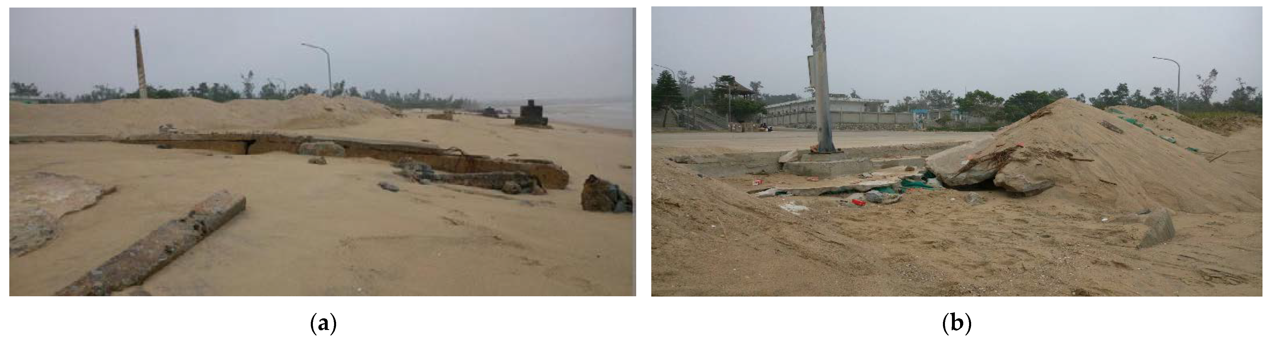
In summary, the long-term natural factors of ocean currents, tides and typhoons, the anthropic factors of illegal sand mining, and coastal development, have caused the loss of territory in Kinmen, damage tp the living environment, reducing the habitat of the lancelet, and the impact on the benthic environment would ultimately lead to the depletion of fishery resources. It shows that the Kinmen–Xiamen waters is facing a serious marine environmental protection crisis. This relies on the attention and collective wisdom of all parties to formulate a marine-environment protection policy and relevant specific practices to enhance the protection of marine resources. At present, in response to the regression of the coastline, the Kinmen County Government has put small gravel in black canvas bags with big boulders on top in order to prevent the continuous collapse of coastline soil, as shown in Figure 7a,b. However, the effectiveness has not yet be verified. In addition to education of marine ecological conservation, short-term measures should include removing the nets and fishing equipment illegally deployed at sea by fishermen. The six major methods are driving away or detaining the ships; detaining personnel for investigation; confiscating ships, fishing equipment, and fish harvested; and administrative fines. Strong law enforcement should be implemented to fully protect the environmental resources and marine conservation of the Kinmen Waters. Moreover, in the short term, it should impose severe punishment on illegal-sand-pump dredgers. To achieve the effect of severe punishment on, and deterrence to, the sand=pump dredgers, additional fine may be imposed by the Coast Guard Administration in accordance with Article 80-1 of the Act Governing Relations between the People of the Taiwan Area and the Mainland Area. The sanction given to the Coast Guard Administration to auction, sell, dispose, or preserve the vessel for public use without compensation should also be evaluated. Moreover, it is expected that mainland China could jointly formulate “Cross-strait Natural Ecological Conservation Cooperation Agreement” as soon as possible, to effectively regulate and prevent illegal-sand-mining activities.

4.3.2. Maintaining Maritime Safety

The Kinmen–Xiamen waters is narrow and congested. Different channels, fishing boats activities and official ships for law enforcement have made the sea area almost saturated. If a sand-pump dredger broke into the Kinmen–Xiamen waters for illegal sand mining, it would pose a threat to maritime safety in that sea area. It is an existing and urgent issue of “Maintaining Maritime Safety” in the Kinmen–Xiamen waters. The solution does not only rely on the attention of the government and non-governmental organizations, but the cross-strait governments should also muster the courage to ban illegal sand-pump dredgers as well. On one hand, the Coast Guard Administration in Kinmen should increase the capabilities of law enforcement. On the other hand, the cross-strait governments should obtain consensus on law enforcement through communication and coordination. In terms of practice, the measures may include combining the radar to master real-time movement, on-site investigation, banning and bringing to justice, enhancing the patrol of the channels, and enhancing the marine services in Beiding, Liuluo Bay, Jinlie Waterway, Dadan and Erdan.

4.3.3. Cross-Strait Jointly Ban Illegal-Sea-Sand Mining Cooperation Mechanism

Taiwan and mainland China have signed the “Cross-Strait Joint Crime-Fighting and Judicial Mutual Assistance Agreement” to effectively combat the illegal-sand-mining activity. In May 2015, Taiwan spent a lot of efforts to promote the “Xia Zhang Meeting” between the chairman of the Strait Exchange Foundation and Association for Relations across the Taiwan Strait, and reached an agreement on the issue of illegal sand mining. According to Cross-Strait Joint Crime-Fighting Agreement, both sides have simultaneously banned and investigated the illegal activities and would continue to discuss the effective implementation of the solution. With the agreement, both sides had carried out 19 joint law-enforcement operations by the end of 2015, and seized 56 ships of illegal sand mining that damaged the marine environment. Right after Tsai, Ing-Wen was inaugurated as Taiwan’s 14th president on 20 May 2016, the joint law-enforcement mechanism in the Kinmen–Xiamen waters became less active than before. Although the cross-strait first line law-enforcement agencies still have the cooperation mechanism, the achievement is limited in the absence of a formal operation mechanism.
However, the council speaker of Kinmen County Council led a delegation visiting the Xiamen Ocean and Fisheries Bureau on 5 June 2018. It was to establish that a cross-strait joint law-enforcement mechanism in the Kinmen–Xiamen waters would be very important to the protection of marine organisms and the conservation of the marine resources and ecology of Kinmen Waters. Both parties also agreed that the law-enforcement unit of Xiamen Ocean and Fisheries Bureau and Kinmen Offshore Flotilla establish a rapid law enforcement cooperation mechanism to communicate and respond in real time to demonstrate the effectiveness of law enforcement, so that the resources in the Kinmen–Xiamen waters could be well protected [18]. In addition, the Xiamen Municipal Ocean Development Bureau mentioned on 30 September 2018 that the maritime-patrol department in mainland China should “actively promote Xiamen-Kinmen coordinated law enforcement, complete and improve cooperation mechanism with the Kinmen coast guard unit, implement the normalization of coordinated law enforcement in Xiamen and Kinmen, exchange information in real time, jointly clean up the illegal fishing gear in the border waters, and jointly seize the illegal ships crossing the border” (Xiamen Ocean Development Bureau, 2018). Moreover, the Xiamen Ocean Comprehensive Administrative Law Enforcement Detachment carried out joint law enforcement with Kinmen, Zhangzhou, and Quanzhou on 20 August 2019, to maintain the order of fishery production in Xiamen Bay. During the operation, seven cross-strait vessels for law enforcement from the three regions carried out a coordinated law-enforcement cruise along the waters from Chijiao to Erdan Island [44].
In summary, it is necessary for cross-strait governments from the four regions to carry out coordinated law enforcement in the Kinmen–Xiamen waters. Therefore, it is not only important but is necessary to establish the MSP marine management mechanism in Kinmen–Xiamen by Kinmen, Xiamen, Zhangzhou, and Quanzhou.

4.4. Establishing an MSP Marine Management Mechanism by Kinmen, Xiamen, Zhangzhou and Quanzhou

The establishment of a joint management mechanism for the sea area between Kinmen and Xiamen is the fundamental solution, i.e., a mechanism for the great Kinmen and Xiamen MSP. A Kinmen and Xiamen MSP, based on a cross-sector management approach, is a concept of marine management with an objective to break administrative boundaries and resolve problems incurred by fragmented governance through holistic marine management [45]. Therefore, a Kinmen and Xiamen MSP requires the four main administrative bodies to cooperate with one another for the collaborative collection and analysis of spatial data regarding the sea area between Kinmen and Xiamen and for the proposal of framework management. Relevant stakeholders are encouraged to partake in the dialogues and negotiations. By clarifying opinions and relations with one another in the process of making an MSP, a management consensus may be achieved for joint marine management [9].
Nevertheless, a Kinmen and Xiamen MSP still experience some challenges, such as the lack of a unified coordination and management mechanism. From an ecosystem perspective, the sea area between Kinmen and Xiamen is a complete marine ecosystem that needs integrated management. However, according to the current administrative boundary, the sea area between Kinmen and Xiamen is under the jurisdiction of four municipal governments, and is also involved with the different marine-management systems of Taiwan and China. The current differentiated management methods of administrative divisions have brought difficulty to the protection of marine ecosystems in the sea area. In the absence of the unified planning and protection of marine resources and with different governing rules and policy guidance for central or local legislation for marine jurisdictions, there must exist conflict management and loopholes in law enforcement. Hence, in the sea area, there has been long-standing illegal sand mining, blast fishing, and electrofishing. The sea area between Kinmen and Xiamen is experiencing an uncontrollable overuse of marine resources. There is also a lack of cross-sector cooperation on marine-environment-quality monitoring and marine-pollution prevention and control. Although the governments of Kinmen and Xiamen are aware of the importance of ecosystem management and joint management, they still act independently in matters of marine-environment-quality monitoring and marine-pollution prevention and control, without cross-sector cooperation. Conflicts in space and time among maritime activities make it difficult to strike a balance between development and protection. China once attempted to resolve the conflicts among various maritime activities through marine-functional zoning and achieved some results. However, subject to the administrative framework, there is still no overall arrangement for marine activities in the sea area between Kinmen and Xiamen [9]. The economy of Kinmen currently relies on the benefits brought by the tourism industry. Its policy concerning environmental protection has always been clear, but there is not yet any marine-functional zoning or MSP to reduce conflicts between marine development and protection. Both governments are required to join forces to innovate a marine-managing mechanism and actively promote an ecosystem-based MSP to deal with existing problems and challenges in the sea area. If both Taiwan and China put aside political disputes and the immediate interests of the respective administrative regions and cooperate with each other on joint management, the healthy and harmonious development of the Kinmen and Xiamen waters can be realized.
Basically, a framework of MSP is needed to proceed with the establishment of a sustainable environmental plan between Kinmen and Xiamen to reduce the destruction of the marine environment and changes in the coastal landforms. Although there are many political issues between Taiwan and China, due to increasing conflicts among stakeholders in relation to this sea area, governments on both sides should ignore the political factors and utilize the MSP mechanism to resolve the conflicts that are less involved in politics. This is also a common expectation from the governments and people of Kinmen, Xiamen, Zhangzhou, and Quanzhou.
To conclude, this study has collected a lot of information from literature, which has revealed many discussions and data on the impact of the long-term natural factors and anthropic factors on collapse of Kinmen coastline, damage of marine ecology, and maritime safety. This study has been supplemented with field surveys, in-depth interviews, and expert opinion surveys, which have verified many findings of the existing literature. However, the Kinmen coastline and the current situation of sea area has been caused by multiple factors. It may not be completely attributable to any single factor, nor can it measure the ratio of the liability. This would be the limitation of this study.

5. Conclusions

In summary, the space to which the marine environment belongs is a complex social–ecological system. Whether people use this sea area or not, stakeholders will be affected by this social–ecological system. How to plan and properly use the marine environment is extremely important. Regarding the longstanding marine environmental issues and the collapse of the coastline in the Kinmen–Xiamen sea area, this study concluded, from a literature review, interviews, and a panel discussion, that thorough efforts of stakeholders from both Taiwan and China are needed. By using an MSP as a guiding tool to establish a management mechanism for the sea area between Kinmen and Xiamen, the above problems can be effectively solved.
During the study period, scholars, experts, and law-enforcement agents from Taiwan and China held a symposium on an MSP for Kinmen and Xiamen at the National Quemoy University. The consensus reached in the symposium can be used as an important reference for the future establishment of an MSP in the sea area between Kinmen and Xiamen by the governments of Kinmen, Xiamen, Zhangzhou, and Quanzhou. In the symposium, it was suggested that (1) Taiwan and China should establish a “Cross-Border Cooperation Management Platform for the sea area between Kinmen and Xiamen” with scientific research organizations from both sides as the basis; (2) the implementation of a Kinmen and Xiamen MSP may encounter complicated difficulties. Both sides can start with current hot issues of illegal sand mining in this sea area and gradually proceed with research and development in related fields; (3) the competent organizations in Kinmen, such as the Fisheries Research Institute of Kinmen County and coast guard, should actively provide data and necessary scientific research assistance for the establishment of the Kinmen and Xiamen MSP; (4) Kinmen and Xiamen MSPs are necessary to create a data-sharing mechanism, such as cloud sharing or an online database; (5) in the future, a cross-strait Kinmen and Xiamen MSP implementation-leading group must be built to combine scientific research and the administrative forces of both sides to make plans in future. The previous suggestions can also be used as a reference for the governance of countries surrounding similar sea areas, such as the marine pollution problems of countries surrounding the Baltic Sea and the Mediterranean Sea.

Recommendations for Putting MSP into Practice

According to the findings of this study, an MSP could be applied to the cross-strait joint transboundary-marine-governance mechanism. It is necessary for an MSP to include all stakeholders in the planning system, i.e., through public participation, public opinion should be solicited and public support won over. The specific recommendations are as follows:
Firstly, the two sides of the strait should establish a cooperative management platform. An implementation-leading group should be formed and cross-strait discussion meetings should be held. For example, the two sides of the strait should establish a “Kinmen-Xiamen Waters Cooperation Management Platform” based on the scientific research organizations of both sides. Furthermore, the implementation of an MSP in the Kinmen–Xiamen waters may face many difficulties. Therefore, this could start from the hot issues faced in this sea area to monitor and informatize the location and time intervals of ocean currents, monsoons, tides, coastal development, and other anthropic factors such as unau-thorized sand mining. Thereafter, the research and development of related fields should be gradually promoted, and the problems of illegal sand mining would be solved, finally.
Second, is about the schedule and approach of MSP implementation. The construction of an MSP in the Kinmen–Xiamen waters is a creative interaction process involving the government and research institutions. Cross-strait academic circles could make use of informal exploration and consultations, such as perspective sharing in seminars, discussions or scientific-research cooperation in symposiums, or providing recommendations on cross-strait joint transboundary marine governance in the form of research results and reports. The schedule and approach are shown in Figure 8, and are described as follows:
In the early stage of promotion, cross-strait academic circles could sort out and analyze the MSP theory and famous cases in order to provide empirical guidance and theoretical reference for the construction of an MSP in the Kinmen–Xiamen waters. Thus, in the primary stage of MSP construction, the local governments on both sides of the strait could explore the emerging public-management theories, such as global environment governance, cross-domain governance, and EBM, to reach the common consensus of an MSP. The proposal and development of EBM theory has provided effective theoretical guidance and practical value for the governance of transboundary marine environmental issues. In addition, in order to be successful, famous MSP practical cases should be analyzed. For example, the “Elkhorn Slough Tidal Wetland Project” included a national coordination and leadership mechanism in the policies and plans. If the theories and cases mentioned above could be considered when MSP is put into practice, it would be beneficial to integrate the actual situations of the Kinmen–Xiamen waters for comparative analysis, and provide practical guidelines for the construction of an MSP.
In the mid-stage of construction, the cross-strait academic circles could compare and analyze the different stakeholder, law, and technologies structures of both sides of the strait, determine areas of common interests, and provide policy references for government agencies. For example, in terms of stakeholders, it is required to define stakeholders first, followed by clearly regulating their participation methods, time and role, and understanding public opinions to avoid conflicts of interest. In terms of legal structures, the similarities, and differences, in the jurisdiction of the Kinmen–Xiamen waters could be compared. In terms of technical structure, it could be started from the establishment of a spatial database of the Kinmen–Xiamen waters to facilitate analysis of the geographic information system (GIS). In particular, the issue of cross-strait cooperation to combat the destruction of the marine environment involves the application of laws and the legal basis of enforcement methods. It is necessary to integrate the legal systems of both sides of the strait before conducting a transboundary MSP. Analysis of technology structures could help the establishment and sharing of cross-strait spatial database information. Obtaining high-quality and continuously updated ocean data would be critical for decision makers. Although there may be certain difficulties in the process, such as the matching of different administrative management systems and processes, and the accessibility and consistency of data and effective communication methods, local governments must constantly maintain the interests of their jurisdictions while seeking for cooperation in the areas of common interests [46] in order to overcome the existing issues of transboundary marine governance.
In the latter stage of construction, the cross-strait academic circle should make a preliminary assessment of the Kinmen–Xiamen waters MSP, and adjust accordingly. It is necessary to conduct environmental-impact assessments for the transboundary spatial planning of the Kinmen–Xiamen waters. After the implementation, the possible impact on the Kinmen–Xiamen waters should be identified, predicted, and systematically evaluated. Efforts should be made to promote the sharing of interests and risks between the governments of both sides of the strait, and provide scientific guidance and policy planning for the governments of both sides of the strait in transboundary marine governance.
The three stages of constructing a Kinmen–Xiamen MSP are closely linked. We could say that the cross-strait academic circle would be the first step of the entire process of constructing a transboundary MSP in the Kinmen–Xiamen waters. In the preparation process, the cross-strait academic circle should solve several critical issues, including the way of promoting communication and exchange between cross-strait governments, the way to comprehensively consider the needs of stakeholders and organize public participation, define the required data, and establish a common information system. These three fundamental issues affect the entire process of constructing a Kinmen–Xiamen MSP [9] (pp. 12–16). Especially, the destruction of the marine environment involves multiple aspects of law enforcement, marine conservation, and maritime security. The governments and people on both sides of the Taiwan Strait can only take care of the balance between marine ecology and human life through careful planning and communication in the three stages through an MSP.
In summary, to effectively remediate the environment of Kinmen–Xiamen water and the collapse of the Kinmen coastline, it is the top priority to establish a transboundary marine governance mechanism based on an MSP and public awareness of environmental protection. Unfortunately, this would involve the central governments of mainland China and Taiwan, and transboundary governance between local governments. With the development of marine ecological civilization worldwide, the topics of transboundary marine governance have begun to catch the attention of academia and government departments. As transboundary waters under the joint jurisdiction of Kinmen (Taiwan) and Xiamen (mainland China), the Kinmen–Xiamen waters are under the independent jurisdiction of two governments due to the two political entities. This has triggered illegal activities across the boundary in Kinmen Waters, such as smuggling and illegal immigration, floating marine debris, marine pollution, and illegal sand mining. The traditional administrative boundary governance can no longer solve the complex problems in transboundary waters. The governance effectiveness and efficiency are worrying. Although both Kinmen and Xiamen have extensive cooperation in the Kinmen–Xiamen waters, such as “channeling water to Kinmen”, “cross-border fishing”, “illegal sea sand mining” and “jointly releasing fries to the sea”, it is restricted to the cooperation between the local governments of Kinmen and Xiamen, and is full of uncertainty due to the political factors [47]. Therefore, at the management level, it is necessary for the governments on both sides of the strait to establish an MSP-based transboundary marine governance mechanism in the Kinmen and Xiamen waters.

Author Contributions

Conceptualization, R.-H.K.; Formal analysis, C.-C.C.; Investigation, C.-C.C. and R.-H.K.; Methodology, R.-H.K.; Resources, C.-C.C. All authors have read and agreed to the published version of the manuscript.

Funding

This research received no external funding.

Institutional Review Board Statement

Not applicable.

Informed Consent Statement

Informed consent was obtained from all subjects involved in the study.

Data Availability Statement

Not applicable.

Conflicts of Interest

The authors declare no conflict of interest.

References

  1. Douvere, F. The importance of marine spatial planning in advancing ecosystem-based sea use management. Mar. Policy 2008, 32, 762–771. [Google Scholar] [CrossRef]
  2. Rempis, N.; Tsilimigkas, G. Marine spatial planning on Crete Island, Greece: Methodological and implementation issues. J. Spat. Sci. 2021. [Google Scholar] [CrossRef]
  3. Ehler, C.; Douvere, F. Marine Spatial Planning: A Step by Step Approach toward Ecosystem-Based Management. Intergovernmental Oceanographic Commission and Man and the Biosphere Programme; IOC Manual and Guides No.53, ICAM Dossier No.6; UNESCO: Paris, France, 2009. [Google Scholar]
  4. Kyriazi, Z. From identification of compatibilities and conflicts to reaching marine spatial allocation agreements. Review of actions required and relevant tools and processes. Ocean Coast. Manag. 2018, 166, 103–112. [Google Scholar] [CrossRef]
  5. Thomas, H.L.; Macsharry, B.; Morgan, L.; Kingston, N.; Moffitt, R.; Stanwell-Smith, D.; Wood, L. Evaluating official marine protected area coverage for Aichi Target 11: Appraising the data and methods that define our progress. Aquat. Conserv. Mar. Freshw. Ecosyst. 2014, 24, 8–23. [Google Scholar] [CrossRef]
  6. Noblea, M.M.; Harastib, D.; Pittocka, J.; Dorana, B. Understanding the spatial diversity of social uses, dynamics, and conflicts in marine spatial planning. J. Environ. Manag. 2019, 246, 929–940. [Google Scholar] [CrossRef] [PubMed]
  7. Maragno, D.; Pozzer, G.; Bassan, N.; Musco, F. Land–Sea Interaction: Integrating Climate Adaptation Planning and Maritime Spatial Planning in the North Adriatic Basin. Sustainability 2020, 12, 5319. [Google Scholar] [CrossRef]
  8. Stelzenmüller, V.; Lee, J.; South, A.; Foden, J.; Rogers, S.I. Practical tools to support marine spatial planning: A review and some prototype tools. Mar. Policy 2013, 38, 214–227. [Google Scholar] [CrossRef]
  9. Lee, S.H.; Xue, X.Z. Research on Synergetic Governance Model for the Sea Area between Xiamen and Kinmen-Based on the Perspective of Transboundary Marine Spatial Planning. In Proceedings of the Second Symposium and Discussion on Conference Development of Xiamen and Kinmen, Xiamen, China, 16 December 2017; p. 16. [Google Scholar]
  10. Janssen, R.; Arciniegas, G.; Alexander, K.A. Decision support tools for collaborative marine spatial planning: Identifying potential sites for tidal energy devices around the Mull of Kintyre, Scotland. J. Environ. Plan. Manag. 2015, 58, 719–737. [Google Scholar] [CrossRef]
  11. Thoya, P.; Maina, J.; Möllmann, C.; Schiele, K.S. AIS and VMS Ensemble Can Address Data Gaps on Fisheries for Marine Spatial Planning. Sustainability 2021, 13, 3769. [Google Scholar] [CrossRef]
  12. Commission of the European Communities. Communication from the Commission. In Roadmap for Maritime Spatial Planning: Achieving Common Principles in the EU; Commission of the European Communities: Brussels, Belgium, 2008. [Google Scholar]
  13. Douvere, F. Marine Spatial Planning Concepts, Current Practice and Linkages to Other Management Approaches; Ghent University: Ghent, Belgium, 2010. [Google Scholar]
  14. Tsilimigkas, G.; Rempis, N. Maritime spatial planning and spatial planning: Synergy issues and incompatibilities. Evidence from Crete island, Greece. Ocean. Coast. Manag. 2017, 139, 33–41. [Google Scholar] [CrossRef]
  15. Liu, T.S.; Chang, K.M. China Sand Pump Dredgers Crossed Boundary to Illegally Mine Sea Sand in Kinmen Sea Area for a Long Time to Sabotage Local Ecology, Influence Channel Safety, and the Land Loss by Coastline Recession; Done by Taiwan; Control Yuan, Investi-gation Case No.: 104Nei-Diao0025. Reviewed on: 4 June 2015. 2015. Available online: http://www.cy.gov.tw/sp.asp?xdurl=./CyBsBox/CyBsR1.asp&ctNode=910 (accessed on 21 August 2020).
  16. Hu, W.; Yu, W.; Ma, Z.; Ye, G.; Dang, E.; Huang, H.; Chen, B. Assessing the ecological sensitivity of coastal marine ecosystems: A Case Study in Xiamen Bay, China. Sustainability 2019, 11, 6372. [Google Scholar] [CrossRef] [Green Version]
  17. Coast Guard Administration, R.O.C. Discussion on the Enhancement of Patrol Work in Kinmen; Judicial Forum: Taipei, Taiwan, 2012; pp. 184–186. [Google Scholar]
  18. Kao, R.H.; Hsu, C.H.; Kao, J.C.; Yang, F.C. A study on the influence of the marine environmental deterioration and maritime safety from carrying illegal sand mining in the sea area between Kinmen and Xiamen-The case of mainland China boats. Transp. Plan. J. 2017, 46, 51–84. [Google Scholar]
  19. Chang, Y.; Chu, K.W.; Chuang, Z.H. Sustainable coastal zone planning based on natural processes andhuman activities: A model from case study in Tainan, Taiwan. Landsc. Urban Plan. 2018, 174, 24–32. [Google Scholar] [CrossRef]
  20. Kudalc, M.D. Impact of port development on the coastline and the need for protection. Indian J. Geo-Mar. Sci. 2010, 39, 597–604. [Google Scholar]
  21. Kuo, S.R.; Lin, H.J.; Shao, K.T. Seasonal changes in abundance andcomposition of the fish assemblage in Chiku Lagoon, southwestern Taiwan. Bull. Mar. Sci. 2001, 68, 85–99. [Google Scholar]
  22. Chiau, W.Y. Lagoon management and black-faced spoonbill conservation: 500 issues and challenges in the greater Chiku area, Taiwan. J. Coast. Res. 2006, 39, 912–914. [Google Scholar]
  23. Turner, W.R.; Brandon, K.; Brooks, T.M.; Costanza, R.; Da Fonseca, G.A.B.; Portela, R. Global conservation of biodiversity and ecosystem services. BioScience 2007, 57, 868–873. [Google Scholar] [CrossRef] [Green Version]
  24. Seabergh, W.C. Jetty Spur Functional Design at CoastalInlets; Effects on Nearshore Circulation and Potential Sediment Movement; ERDC/CHL CHETN IV-66; U.S. Army Engineer Research and Development Center: Vicksburg, MS, USA, 2006. [Google Scholar]
  25. Chang, S.Y. Study of the Influence on Wai-San-Ding Sandbank by Major Rivers and Mailiaoindustrial Garbor. Master’s Dissertation, Department of Marine Environment and Engineering, National Sun Yat-Sen University, Kaohsiung, Taiwan, 2014. Unpublished. [Google Scholar]
  26. Lin, Q.Y. A Case Study of Bottom Topography Variation under Wave Current Interaction in the Vicinity of Kinmen. Master’s Dissertation, Institute of Physical Oceanography, National Sun Yat-Sen University, Kaohsiung, Taiwan, 2008. Unpublished. [Google Scholar]
  27. Water Resources Agency, R.O.C. Field Study on Coastal Monitoring and Investigation in Kimen; The 8th River Management Office, Water Resources Agency, Ministry of Economic Affairs, R.O.C.: Kaohsiung, Taiwan, 2011.
  28. Water Resources Agency, R.O.C. Field Study on Coastal Monitoring and Investigation in Kimen (1/2); The 8th River Management Office, Water Resources Agency, Ministry of Economic Affairs, R.O.C.: Kaohsiung, Taiwan, 2014.
  29. Huang, M.D. Drifting Trash and Sand Mining Is a Nightmare for Kinmen-Xiamen Environment. World Sea Transp. 2013, 35. Available online: http://www.lofter.com/postentry?from=search&permalink=1cc81401_42cf858 (accessed on 30 September 2019).
  30. Weng, Y.B.; Hu, D.G. An Investigation and Analysis of the Implementation of Reclamation Project in Recent 10 Years in Fujian. Marit. Dev. Manag. China 2015, 12, 11–12. [Google Scholar]
  31. Kao, R.H.; Cho, C.C.; Lin, T.H.; Kim, Y.H. A Study on the Concept of Spatial Planning in Kinmen and Xiamen SeaArea from the Marine Environmental Deterioration and Maritime Safety—The Case of Trespassed Fishing, Illegal Sea Sand Mining and Floating Waste. Marit. Q. 2019, 28, 79–110. [Google Scholar]
  32. Kannen, A. Challenges for marine spatial planning in the context of multiple sea uses, policy arenas and actors based on experiences from the German North Sea. Reg. Environ. Chang. 2014, 14, 2139–2150. [Google Scholar] [CrossRef]
  33. Maguire, B.; Potts, J.; Fletcher, S. The role of stakeholders in the marine planning processstakeholder analysis within the Solent, United Kingdom. Mar. Policy 2012, 36, 246–257. [Google Scholar] [CrossRef]
  34. Gilliland, P.M.; Laffoley, D. Key elements and steps in the process of developing ecosystem-based marine spatial planning. Mar. Policy 2008, 32, 787–796. [Google Scholar] [CrossRef]
  35. Ehler, C. Conclusions: Benefits, lessons learned, and future challenges of marine spatial planning. Mar. Policy 2008, 32, 840–843. [Google Scholar] [CrossRef]
  36. Xu, T.W.; Ou, C.H. Preliminary Research and Analysis of the Use and Management of Taiwan Sea Areas; CTCI Foundation: Taipei, Taiwan, 2016. [Google Scholar]
  37. Kinmen National Park Headquarters. The Investigation and Research of Kinmen Marine Ecosystems—An Investigation and Application of the Resource of Lancelet (2); Commissioned Research Project in 2012; Kinmen National Park Headquarters: Kinmen, Taiwan, 2012; p. 125. [Google Scholar]
  38. Chinatimes.com. No BOT Project for Kinmen Coastal Regions (19 May 2014). 2014. Available online: http://www.chinatimes.com/realtimenews/20140519004702-260402 (accessed on 28 June 2019).
  39. Fishery Industry Ship Inspection Bureau, P.R.O.C. Cross-Strait Collaborative Law Enforcement for the Protection of Strait Security. 2015. Available online: http://www.cfr.gov.cn/zwdt/dfzx/201512/t20151231_164313.htm (accessed on 28 June 2019).
  40. Kinmen Daily News. Speaker Hong Led a Delegation Visiting the Xiamen Ocean and Fisheries Bureau. Published on 6 June 2018. Available online: https://www.kinmen.gov.tw/NewsContent2.aspx?n=98E3CA7358C89100&sms=BF7D6D478B935644&s=BC70E3844919CA2D (accessed on 25 May 2021).
  41. Xiamen Municipal Ocean Development Bureau. The Xiamen City Detachment Takes the Lead in the Development of Joint Law Enforcement to Maintain the Order of Fishery Production in Xiamen Bay. 2019. Available online: https://twgreatdaily.com/drn4vGwBJleJMoPMEPTI.html (accessed on 20 August 2019).
  42. Coast Guard Administration. Coast Guard Annual Statistical Report. 2020. Available online: https://www.cga.gov.tw/GipOpen/wSite/mp?mp=999 (accessed on 24 July 2021).
  43. Xiamen Municipal Government Portal Site. Issuing the notice of Xiamen Municipality’s Work Plan for Fighting against Illegal Mining of Sea Sand. 2016. Available online: http://www.xm.gov.cn/zwgk/flfg/sfbwj/201411/t20141127_999542.htm (accessed on 24 August 2021).
  44. Xiamen Municipal Ocean Development Bureau. Law enforcement in Xiamen Waters. Published on 20 August 2019. 2018. Available online: http://hyj.xm.gov.cn/gzdt/bmdt/zhzf/201908/t20190820_2328082.htm (accessed on 24 May 2020).
  45. Flannery, W.; O’Hagan, A.M.; O’Mahony, C.; Ritchie, H.; Twomey, S. Evaluating conditions for transbounary Marine Spatial Planning: Challenges and opportunities on the island of Ireland. Mar. Policy 2015, 51, 86–95. [Google Scholar] [CrossRef] [Green Version]
  46. Jay, S.; Alves, F.L.; O’Mahony, C.; Gomez, M.; Rooney, A.; De Vivero, J.L.S.; Almodovar, M.; Goncalves, J.; Gee, K.; Fernandes, M.L.; et al. Transboundary dimensions of marine spatial planning: Fostering inter-jurisdictional relations and governance. Mar. Policy 2016, 65, 85–96. [Google Scholar] [CrossRef]
  47. Kao, J.C.; Cho, C.C.; Kao, R.H. A Study on Transboundary Marine Governance of Floating Marine Debris—Taking Kinmen–Xiamen Waters between China and Taiwan as an Example. Sustainability 2021, 13, 14063. [Google Scholar] [CrossRef]
Figure 1. Study area. Data source: [16] (p. 6372).
Sustainability 14 05006 g001
Figure 2. Map showing position of Kinmen. Date resource: http://www.waterpolitics.com/2015/05/25/peace-pipe-chinas-plan-to-pump-water-to-taiwan (accessed on 4 May 2021).
Sustainability 14 05006 g002
Figure 3. Photo of a coastal military fortress showing eroded foundations. Data source: [18].
Sustainability 14 05006 g003
Figure 4. Oyster sticks are buried more than 50 cm. Data source: [18].
Sustainability 14 05006 g004
Figure 5. Popular illegal-sand-mining areas in the sea area between Kinmen and Xiamen. Data source: https://www.researchgate.net/figure/The-location-of-the-Kinmen-archipelago-left-and-the-relative-location-of-Lieyu-within_fig1_320057188 (accessed on 8 May 2021). Note: red bars mean illegal-sand-mining areas that are popular among border-crossing ships from China. The map of popular illegal-sand-mining areas was drawn based on Taiwanese CGA’s arrest data for years.
Sustainability 14 05006 g005
Figure 6. (a,b) The bottom of bollard for navy landing boat’s supply operation is exposed and street lamp pole is collapsed. Data source: [18], and photographed by this study team. Note: (a) is taken from a distance, (b) is taken from a close distance.
Sustainability 14 05006 g006
Figure 7. (a,b) The Kinmen government set up the construction to prevent the continued collapse of coastline soil. Data source: [18], and photographed by this study team. Note: (a) is taken from a distance, (b) is taken from a close distance.
Sustainability 14 05006 g007
Figure 8. Kinmen–Xiamen MSP route map. Data source: referred to and amended from: [9] (p. 16).
Sustainability 14 05006 g008
Table 1. Performance results of Coast Guard Administration’s capturing of the intruding illegal-sand-mining ships in Kinmen waters from 2005 to 2020.
YearNumber of Vessels (Person)Volume of Sand Stolen (Cubic Meter)Fined by Kinmen County Government and Judiciary (Ten Thousand New Taiwan Dollars)
200510100
2006000
200793350700
20087650600
20096 (35)1250600
201051770530
20115873983
20127 (36)20101940
2013414001475
20141400390
20153 (21)15600
20163 (11)10001190
20172 (14)812600
20182 (13)13002500 (proceeds from the auctions of ships)
20197 (70)16,1708480 (proceeds from the auctions of ships)
20204 (37)30001452 (proceeds from the auctions of ships)
Total6535,54521,740
Data source: [42]. Note: During 2019–2020, there were no captures of ships in Kinmen waters, but in 2019, at least 150 ships were driven away, and in 2020, at least 1000 ships attempting to enter Kinmen waters for illegal sand mining were driven away.
Publisher’s Note: MDPI stays neutral with regard to jurisdictional claims in published maps and institutional affiliations.

