A Model to Support Sustainable Resource Management in the “Etna River Valleys” Biosphere Reserve: The Dominance-Based Rough Set Approach
Abstract
:1. Introduction
2. Materials
2.1. The Biosphere Reserves: Institution, Objectives and Developments
- Seville Strategy (1995): it sets specific objectives, recommendations at the nationalandinternational level and for each BR, and implementation indicators. It invites the interested parties to acquire all the relevant information elements and to assume a full commitment, both in the planning process and in the management and continuous monitoring of the BRS, as well asthrough the creation of advisory bodies. The Seville Strategy identifies the specific role of BRs in developing a new vision of the relationship between conservation and development.
- Statutory Framework of the World Network of BRs (WNBR) (1995): it establishes criteria, functions and procedures for the designation of BRs and sets out the principles for their periodic review.
- Madrid Action Plan (2008): it implements the 2008–2013 MAB (Man and Biosphere Program) Strategy and reiterates the three great challenges of the 21st century: climate change, biodiversity loss and urbanisation; it stresses the strategic importance of involving all stakeholders to ensure the wellbeing of human populations and their development.
- 2015–2025 MAB Strategy (2015): it defines strategic objectives, which are derived directly from the three functions of BRs and identified in the statutory framework of the WNBR and in the global challenge to climate change (Madrid Action Plan for BRs) (UNESCO 2015) [47].
- Lima Action Plan (2016): it establishes objectives, actions and expected results for implementing the 2015–2025 MAB Strategy; it pays particular attention to the achievement of the sustainable development goals and the implementation of the 2030 Agenda (UNESCO 2016) [48].
- MAB Youth Forum (2017): the initiative, first announced at the World Conservation Congress in Lima, offered young people the chance to become actors in the MAB programme in the special territories where they live and ensure the sustainable development of their communities, in line with the Lima Action Plan.
- 1.
- Include a mosaic of ecological systems representative of the main biogeographical regions, including a graduated series of human interventions.
- 2.
- Be important for the conservation of biodiversity.
- 3.
- Offer the possibility to study and demonstrate approaches to sustainable development at a regional level.
- 4.
- Have adequate dimensions to satisfy the aforementioned three peculiar functions, as set out in Article 3.
- 5.
- Divide the territory into zones that support the three main functions of the BRs (core, buffer and transition zones).
- 6.
- Ensure the involvement and participation of the public, local communities and private entities of the territory in the design and implementation of the functions of the reserve.
- 7.
- Provide resource provisions for management mechanisms and human activities in the buffer zones, the definition of a management plan for the Reserve, the designation of authority to implement the plan, and the initiation of research, monitoring, education and training programs.
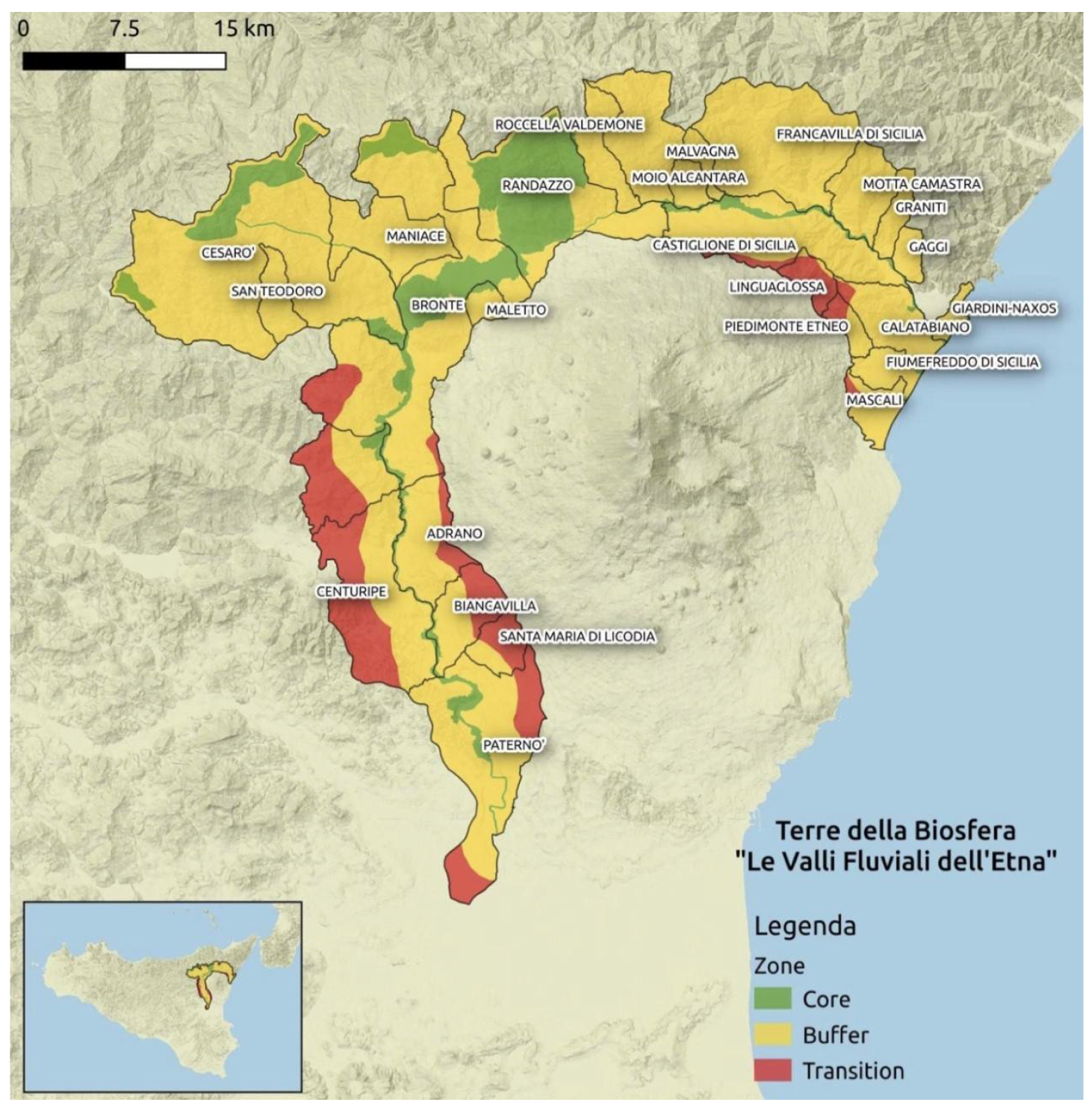
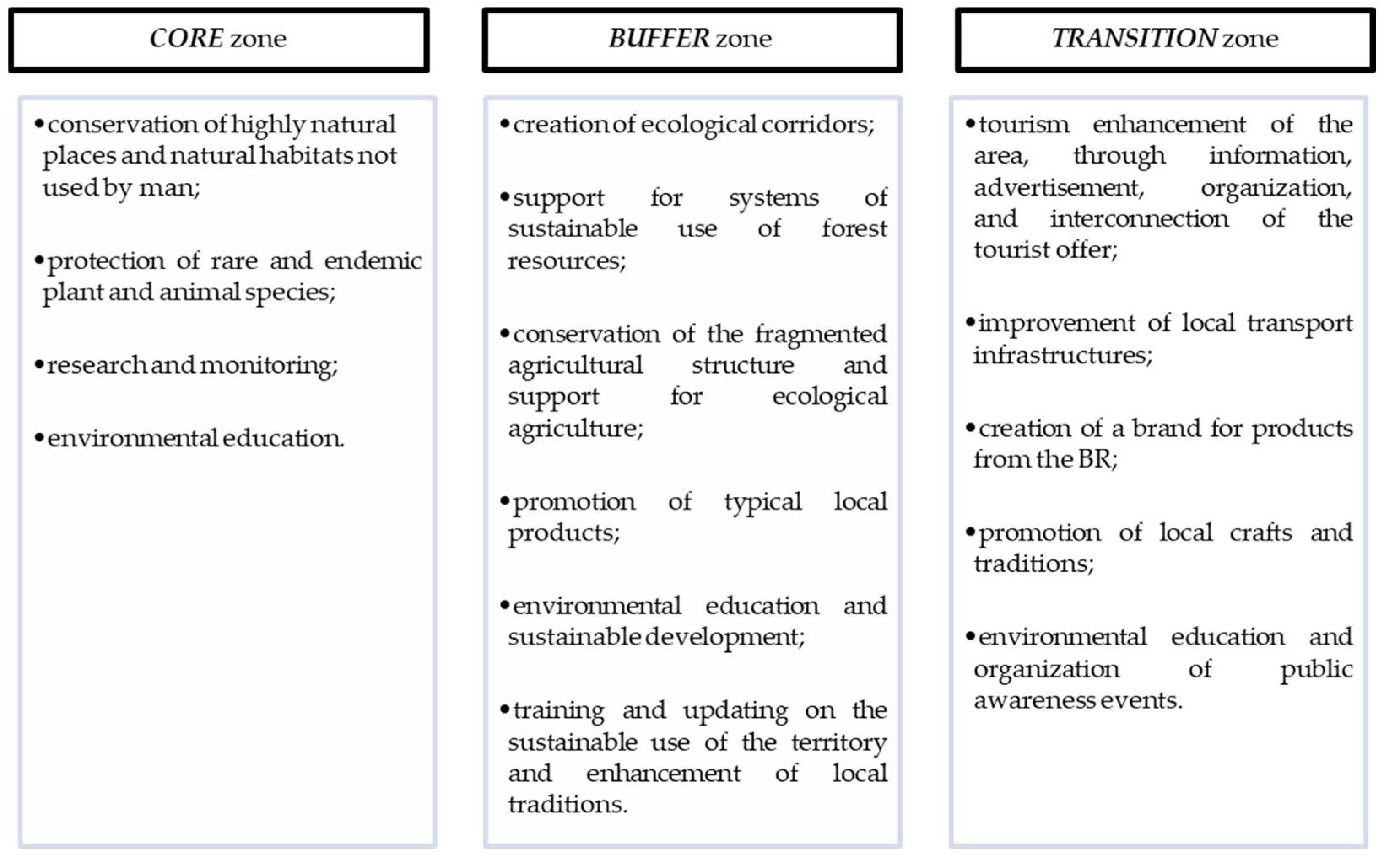
- Core zone (one or more): these are territories protected under specific laws and regulations that are suitable for long-term safeguarding, follow the conservation objectives of the BRs, of sufficient size to meet these objectives, and in which only research and zero-impact activities are allowed.
- Buffer zone (one or more): surrounding or bordering the core zone, in which only activities compatible with conservation objectives can be carried out, including environmental education, ecotourism, monitoring and scientific research.
- Transition zone (one or more): surrounding or bordering the buffer zones, where sustainable use practices are encouraged and developed; it is the part of the reserve where all the activities that allow economic and human development and are socio-culturally and ecologically sustainable are allowed.
2.2. The Biosphere Reserves in Italy and the “Etna River Valleys”Biosphere Reserve Request Proposal (Case Study)
3. Methodology
3.1. The Theory of Rough Sets
3.2. Survey Design
- -
- section 1—questions about company activities;
- -
- section 2—questions about contributions received from the European Union;
- -
- section 3—questions about good practices for the conservation of biodiversity.
- -
- open questions;
- -
- closed questions;
- -
- graded questions.
4. Results
- the willingness of the farmers interviewed to make their own contribution to biodiversity conservation;
- the presence in the area of farms that habitually apply good agricultural practices;
- the urgent need for companies to be supported in the promotion of their products on the market;
- the request for reductions in bureaucratic and administrative burdens related to access to funding measures;
- the need to diversify the areas of support and the criteria for access to funding according to company size, type of production and type of territory;
- the need for periodic and systematic communication with and training of the agricultural and rural population on the contents and aims of European, national and regional policies on agriculture, food and the environment;
- the importance of providing institutional communication campaigns that illustrate the role of agriculture in preserving the environment and the different types of initiatives that can be classified as “good agricultural practices”, so as to activate a greater degree of sensitivity in the population (demand subjects) towards these important functions of agriculture so that a “premium price” can be recognised.
5. Discussions and Conclusions
Author Contributions
Funding
Institutional Review Board Statement
Informed Consent Statement
Data Availability Statement
Conflicts of Interest
References
- IPCC. Global Warming of 1.5 °C. An IPCC Special Report on the Impacts of Global Warming of 1.5 °C Above Pre-Industrial Levels and Related Global Greenhouse Gas Emission Pathways, in the Context of Strengthening the Global Response to the Threat of Climate Change, Sustainable Development, and Efforts to Eradicate Poverty. Masson-Delmotte, V., Zhai, P., Pörtner, H.-O., Roberts, D., Skea, J., Shukla, P.R., Pirani, A., Moufouma-Okia, W., Péan, C., Pidcock, R., et al., Eds.; 2018; Available online: https://www.ipcc.ch/site/assets/uploads/sites/2/2019/06/SR15_Full_Report_Low_Res.pdf (accessed on 12 September 2021).
- Pearce, D.W.; Turner, R.K. Economics of Natural Resources and the Environment; Il Mulino: Bologna, Italy, 1991. [Google Scholar]
- UN. The Sustainable Development Goals Report 2020; United Nations. Department of Economic and Social Affairs: New York, NY, USA, 2020. [Google Scholar]
- Phillips, A.; Borrini-Feyerabend, G. Embracing diversity, equity and change in the landscape. In Parchi e Paesaggid’Europa; Gambino, R., Negrini, G., Eds.; Urbanistica: Rome, Italy, 2009; Volume 139, pp. 52–57. [Google Scholar]
- IPCC. Land Use, Land-Use Change and Forestry. A Special Report of the IPCC; Watson, R.T., Noble, I.R., Bolin, B., Ravindranath, N.H., Verardo, D.J., Dokken, D.J., Eds.; Cambridge University Press: Cambridge, UK, 2000. [Google Scholar]
- OECD. Mainstreaming Biodiversity for Sustainable Development; OECD Publishing: Paris, France, 2018. [Google Scholar]
- Sturiale, L.; Scuderi, A.; Timpanaro, G.; Matarazzo, B. Use and Sustainable Conservation of the Environmental Resources of the Etna Park (UNESCO Heritage): Evaluation Model Supporting Sustainable Local Development Strategies. Sustainability 2020, 12, 1453. [Google Scholar] [CrossRef] [Green Version]
- MEA—Millenium Ecosystem Assessment. Ecosystem and Human Well-Being: Synthesis; MEA: Washington DC, USA, 2005. [Google Scholar]
- UN. Goal 15. Department of Economic and Social Affairs. 2015. Available online: https://www.un.org/development/desa/dpad/sustainable-development-goal/goal-15-life-on-land/ (accessed on 12 November 2021).
- UN. Transforming Our World: The 2030 Agenda for Sustainable Development; United Nations Department of Economic and Social Affairs: New York, NY, USA, 2015. [Google Scholar]
- Ferretti, V.; Bottero, M.; Mondini, G. A spatial decision support tool to study risk and opportunities of complex environmental systems. J. Environ. Account. Manag. 2015, 3, 197–212. [Google Scholar] [CrossRef]
- EEA—European Environment Agency. Exploring Nature-Based Solutions. The Role of Green Infrastructures in Mitigating the Impacts of Weather and Climate-Change Related Nature Hazards; EEA Technical Report 12/2015; EEA: Luxembourg, 2015. [Google Scholar]
- IPBES. Summary for Policymakers of the IPBES Global Assessment Report on Biodiversity and Ecosystem Services; Intergovernmental Science-Policy Platform on Biodiversity and Ecosystem Services (IPBES). 2019. Available online: https://zenodo.org/record/3553579#.Yl_ChtNBxPY (accessed on 12 November 2021).
- Stafford-Smith, M.; Griggs, D.; Gaffney, O.; Ullah, F.; Reyers, B.; Kanie, N.; Stigson, B.; Shrivastava, P.; Leach, M.; O’Connell, D. Integration: The key to implementing the Sustainable Development Goals. Sustain. Sci. 2017, 12, 911–919. [Google Scholar] [CrossRef] [PubMed] [Green Version]
- UNRISD. Global Trends Challenges and Opportunities in the Implementation of the Sustainable Development Goals; United Nations Development Programme and United Nations Research Institute for Social Development: Geneva, Switzerland, 2017; Available online: https://www.unrisd.org/en/library/publications/global-trends-challenges-and-opportunities-in-the-implementation-of-the-sustainable-development-goal (accessed on 21 October 2020).
- UN. Sustainable Development Outlook 2020 Achieving SDGs in the Wake of COVID-19: Scenarios for Policymakers; United Nations Department of Economic and Social Affairs: New York, NY, USA, 2020. [Google Scholar]
- Pappalardo, G.; Pilato, M.; Bracco, S. To what extent are local communities involved in the governance of protected areas? Experiences from a case study in Sicily (Italy). Qual. Access Success 2015, 16, 102–109. [Google Scholar]
- Sturiale, L.; Scuderi, A. The role of green infrastructures in urban planning for climate change adaptation. Climate 2019, 7, 119. [Google Scholar] [CrossRef] [Green Version]
- UNESCO. The Seville Strategy for the World Network of Biosphere Reserves. 1996. Available online: http://www.unesco.org/mab/docs/Strategy.pdf (accessed on 15 October 2021).
- Reed, M.G.; Massie, M. Embracing ecological learning and social learning: UNESCO biosphere reserves as exemplars of changing conservation practices. Conserv. Soc. 2013, 11, 391–405. [Google Scholar] [CrossRef]
- Batisse, M. The Biosphere Reserve: A Tool for Environmental Conservation and Management. Environ. Conserv. 1982, 9, 101–111. [Google Scholar] [CrossRef]
- Onaindia, M.; Ballesteros, F.; Alonso, G.; Monge-Ganuzas, M.; Peña, L. Participatory process to prioritize actions for a sustainable management in a biosphere reserve. Environ. Sci. Policy 2013, 33, 283–294. [Google Scholar] [CrossRef]
- Carbone, F. Multifunctional forest planning: The application of an integrated MCDM—GIS model. Aestimum 1999, 37. [Google Scholar] [CrossRef]
- Matarazzo, A.; Clasadonte, M.T.; Ingrao, C. The (dominance based) rough set approach applied to air pollution in a high risk rate industrial area. Environ. Eng. Manag. J. 2018, 17, 591–599. [Google Scholar] [CrossRef]
- Foti, V.T.; Scuderi, A.; Stella, G.; Sturiale, L.; Timpanaro, G.; Trovato, M.R. The integration of agriculture in the politics of social regeneration of degraded urban areas. In Green Energy and Technology; Springer: Berlin/Heidelberg, Germany, 2018; pp. 99–111. [Google Scholar]
- Tempesta, T.; Vecchiato, D. The value of a properly maintained hiking trail network and a traditional landscape for mountain recreation in the Dolomites. Resources 2018, 7, 86. [Google Scholar] [CrossRef] [Green Version]
- Sturiale, L.; Scuderi, A.; Timpanaro, G.; Foti, V.T.; Stella, G. Social and inclusive “value” generation in metropolitan area with the “urban gardens” planning. In Green Energy and Technology; Springer: Berlin/Heidelberg, Germany, 2020; pp. 285–302. [Google Scholar]
- Scuderi, A.; Sturiale, L.; Foti, V.T. The challenges and opportunity of protected natural areas in Italy: The case study of “simeto oasis”. Qual. Access Success 2017, 18, 401–408. [Google Scholar]
- Guarnaccia, P.; Zingale, S.; Scuderi, A.; Gori, E.; Santiglia, V.; Timpanaro, G. Proposal of a Bioregional Strategic Framework for a Sustainable Food System in Sicily. Agronomy 2020, 10, 1546. [Google Scholar] [CrossRef]
- Foti, V.T.; Scuderi, A.; Timpanaro, G. Organic Social agriculture: A tool for rural development. Calit. -Access Succes 2013, 14, 266–271. [Google Scholar]
- IUCN—International Union for Nature Conservation. Tourism and Visitor Management in Protected Areas—Guidelines for Sustainability; Leung, Y.F., Spenceley, A., Hvenegaard, G., Buckley, R., Eds.; IUCN: Gland, Switzerland, 2015. [Google Scholar]
- Mantić, A. Nature-based solutions for sustainable tourism development in protected natural areas: A review. Environ. Syst. Decis. 2019, 39, 249–268. [Google Scholar] [CrossRef]
- Salerno, F.; Viviano, G.; Manfredi, E.C.; Coroli, P.; Thakuri, S.; Tartari, G. Multiple carrying capacities from a management-oriented perspective to operationalize sustainable tourism in protected areas. J. Environ. Manag. 2013, 128, 116–125. [Google Scholar] [CrossRef]
- Timpanaro, G.; Scuderi, A.; Foti, V.T.; Lo Giudice, V. The Social Relationships’ effectiveness of “agrisocial” farms: A model of sustainable local development. Rev. Sustain. Stud. 2015, 1, 99–116. [Google Scholar]
- Schultz, L.; Duit, A.; Folke, C. Participation, adaptive co-management, and management performance in the world network of biosphere reserves. World Dev. 2011, 39, 662–671. [Google Scholar] [CrossRef]
- Stoll-Kleemann, S.; De La Vega-Leinert, A.C.; Schultz, L. The role of community participation in the effectiveness of UNESCO Biosphere Reserve management: Evidence and reflections from two parallel global surveys. Environ. Conserv. 2010, 37, 227–238. [Google Scholar] [CrossRef]
- Ferreira, A.F.; Zimmermann, H.; Santos, R.; Von Wehrden, H. A Social–Ecological Systems Framework as a Tool for Understanding the Effectiveness of Biosphere Reserve Management. Sustainability 2018, 10, 3608. [Google Scholar] [CrossRef] [Green Version]
- Brenner, L.; Job, H. Challenges to actor-oriented environmental governance: Examples from three mexican biosphere reserves. J. Econ. Hum. Geogr. 2013, 3, 1–19. [Google Scholar] [CrossRef]
- Durand, L.; Figueroa, F.; Trench, T. Inclusion and exclusion in participation strategies in the Montes Azules Biosphere Reserve, Chiapas, Mexico. Conserv. Soc. 2014, 12, 175–189. [Google Scholar] [CrossRef]
- Felix, K.; Cornelius, M.; Hubert, J. Biosphere reserves and their contribution to sustainable development: A value-chain analysis in the Rhön Biosphere Reserve, Germany. Z. Wirtsch. 2014, 58, 164–180. [Google Scholar]
- Abastante, F.; Lami, I.M. A Stakeholders-Oriented Approach to Analyze the Case of the UNESCO’s Man and Biosphere Reserve CollinaPo. In Values and Functions for Future Cities. Green Energy and Technology; Mondini, G., Oppio, A., Stanghellini, S., Bottero, M., Abastante, F., Eds.; Springer: Cham, Switzerland, 2020. [Google Scholar]
- Hein, T.; Blaschke, A.P.; Haidvogl, G.; Hohensinner, S.; Kucera-Hirzinger, V.; Preiner, S.; Reiter, K.; Schuh, B.; Weigelhofer, G.; Zsuffa, I. Optimised management strategies for the Biosphere reserve Lobau, Austria—Based on a multi criteria decision support system. Ecohydrol. Hydrobiol. 2006, 6, 25–36. [Google Scholar] [CrossRef]
- Butti Al Shamsi, K.; Guarnaccia, P.; Cosentino, S.L.; Leonardi, C.; Caruso, P.; Stella, G.; Timpanaro, G. Analysis of relationships and sustainability performance in organic agriculture in the United Arab Emirates and Sicily (Italy). Resources 2019, 8, 39. [Google Scholar] [CrossRef] [Green Version]
- Reed, M.G. The contributions of UNESCO Man and Biosphere Programme and biosphere reserves to the practise of sustainable science. Sustain. Sci. 2019, 14, 809–821. [Google Scholar] [CrossRef]
- Bavington, D. Managerial ecology and its discontents: Exploring the complexities or control, careful use and coping in resource and environmental management. Environments 2002, 30, 3–21. [Google Scholar]
- Williams, B.K. Adaptive management of natural resources: Framework and issues. J. Environ. Manag. 2011, 92, 1346–1353. [Google Scholar] [CrossRef]
- UNESCO. MAB Strategy 2015–2025. Available online: http://www.unesco.org/new/fileadmin/MULTIMEDIA/HQ/SC/pdf/MAB_Strategy_2015-2025_final_text.pdf (accessed on 15 October 2021).
- UNESCO. Lima Action Plan for UNESCO’s Man and the Biosphere (MAB) Programme and Its World Network of Biosphere Reserves (2016–2025). Available online: http://www.unesco.org/new/fileadmin/MULTIMEDIA/HQ/SC/pdf/Lima_Action_Plan_en_final.pdf (accessed on 15 October 2021).
- Foti, V.T.; Scuderi, A.; Stella, G.; Timpanaro, G. Consumer purchasing behavior for “biodiversity-friendly” vegetable products: Increasing importance of informal relationships. Agric. Econ. 2019, 65, 404–414. [Google Scholar]
- Terre della Biosfera. Le Valli Fluviali dell’Etna. Available online: http://www.terrebiosfera.org/ (accessed on 23 October 2020).
- Pawlak, Z. Rough set approach to knowledge-based decision support. Eur. J. Oper. Res. 1997, 99, 48–57. [Google Scholar] [CrossRef] [Green Version]
- Matarazzo, B.; Greco, S.; Slowinski, R. La teoria degli insiemi approssimati (Rough sets). In Strategie, Introduzione alla Teoria dei Giochi e delle Decisioni; Bertino, C., Gambarelli, G., Stach, I., Eds.; Giappichelli: Turin, Italy, 2019; pp. 165–217. [Google Scholar]
- Greco, S.; Matarazzo, B.; Slowinski, R. Rough Approximation of a Preference Relation by Dominance Relations; ICS Research Report 6/96; Warsaw University of Technology: Warsaw, Poland, 1996. [Google Scholar]
- Greco, S.; Matarazzo, B.; Slowinski, R. Rough sets theory for multicriteria decision analysis. Eur. J. Oper. Res. 2001, 129, 1–47. [Google Scholar] [CrossRef]
- Słowiński, R.; Greco, S.; Matarazzo, B. Rough set methodology for decision aiding. In Springer Handbook of Computational Intelligence; Springer: Berlin/Heidelberg, Germany, 2015; pp. 349–370. [Google Scholar]
- Kandziora, M.; Burkhard, B.; Müller, F. Interactions of ecosystem properties, ecosystem integrity and ecosystem service indicators—A theoretical matrix exercise. Ecol. Indic. 2013, 28, 54–78. [Google Scholar] [CrossRef]
- Young, J.; Watt, A.; Nowicki, P.; Alard, D.; Clitherow, J.; Henle, K.; Niemela, J. Towards sustainable land use: Identifying and managing the conflicts between human activities and biodiversity conservation in Europe. Biodivers. Conserv. 2005, 14, 1641–1661. [Google Scholar] [CrossRef]
- Greco, S.; Matarazzo, B.; Slowinski, R.; Stefanowski, J. An algorithm for induction of decision rules consistent with the dominance principle. In International Conference on Rough Sets and Current Trends in Computing; Springer: Berlin/Heidelberg, Germany, 2000; pp. 304–313. [Google Scholar]
- Boggia, A.; Rocchi, L.; Paolotti, L.; Musotti, F.; Greco, S. Assessing Rural Sustainable Development potentialities using a Dominance-based Rough Set Approach. J. Environ. Manag. 2014, 144, 160–167. [Google Scholar] [CrossRef] [PubMed] [Green Version]
- Ferretti, P.; Zolin, M.B.; Ferraro, G. Relationships among sustainability dimensions: Evidence from an Alpine area case study using Dominance-based Rough Set Approach. Land Use Policy 2020, 92, 104457. [Google Scholar] [CrossRef]
- Greco, S.; Matarazzo, B.; Slowinski, R. Decision rule approach. In Multiple Criteria Decision Analysis, State of the art, Strategy; Figueira, J., Greco, S., Ehrgott, M., Eds.; Springer: Berlin/Heidelberg, Germany, 2005; pp. 507–561. [Google Scholar]
- Greco, S.; Matarazzo, B.; Slowinski, R. Dominance-based Rough Set Approach to decision under uncertainty and time preference. Ann. Oper. Res. 2010, 176, 41–75. [Google Scholar] [CrossRef]
- Parco dell’Etna. Studio Dei Flussi Turistici. 2020. Available online: unescoparcoetna.it (accessed on 25 October 2021).
- Scuderi, A.; Sturiale, L.; Timpanaro, G.; Chinnici, G. The participatory planning for preservation and valorization of environmental heritage. In New Metropolitan Perspectives 2020; Bevilacqua, C., Calabro, F., Della Spina, L., Eds.; Springer Nature: Cham, Switzerland, 2021. [Google Scholar]
- Butti Al Shamsi, K.; Compagnoni, A.; Timpanaro, G.; Cosentino, S.L.; Guarnaccia, P. A sustainable organic production model for “food sovereignty” in the United Arab Emirates and Sicily-Italy. Sustainability 2018, 10, 620. [Google Scholar] [CrossRef] [Green Version]
- Matarazzo, A.; Maugeri, E.; Gullo, E.; Romano, P.; Spedalieri, F.; Licciardello, A. The Bioeconomy in Sicily: New green marketing strategies applied to the sustainable tourism sector. Procedia Environ. Sci. Eng. Manag. 2017, 3, 135–142. [Google Scholar]
- Spadaro, G.; Nicotra, A.; Iurato, S.; Matarazzo, A.; Mannino, M. Environmental Management Strategies in Smart Sicilian Food and Technology Chains. Procedia Environ. Sci. Eng. Manag. 2020, 7, 185–193. [Google Scholar]
- Scuderi, A.; Sturiale, L. Multi-criteria evaluation model to face phytosanitary emergencies: The case of citrus fruits farming in Italy. Agriculture 2016, 62, 205–214. [Google Scholar] [CrossRef] [Green Version]

| Rules | A1 | A2 | A3 | A4 | A5 | A6 | A7 | Class | Support |
|---|---|---|---|---|---|---|---|---|---|
| 1 | ≥4 | High | 2,3,5 | ||||||
| 2 | ≤3 | ≤3 | ≤Medium | 4,6,7 | |||||
| 3 | ≤2 | ≤Medium | 6.7 | ||||||
| 4 | ≥4 | High | 1 |
| Rules | A1 | A2 | A3 | A4 | A5 | A6 | A7 | Class | Support |
|---|---|---|---|---|---|---|---|---|---|
| 1 | ≤2 | ≤2 | Low | 6 | |||||
| 2 | ≥3 | ≥3 | High | 1,3,5 | |||||
| 3 | ≤2 | Low | 6 | ||||||
| 4 | ≤2 | ≤Medium | 2.7 | ||||||
| 5 | ≤2 | ≤Medium | 2,4.6 | ||||||
| 6 | ≥4 | High | 3 | ||||||
| 7 | ≥3 | ≥Medium | 1,2,3,4,5,7 |
| Rules | A1 | A2 | A3 | A4 | A5 | A6 | A7 | Class | Support |
|---|---|---|---|---|---|---|---|---|---|
| 1 | ≥4 | High | 1.3 | ||||||
| 2 | ≥3 | ≥Medium | 1,2,3,4,5 | ||||||
| 3 | ≤2 | Low | 6.7 | ||||||
| 4 | ≤3 | ≤Medium | 2,4,5,6,7 | ||||||
| 5 | ≤3 | ≥3 | Medium | 2,4,5 |
| Rules | A1 | A2 | A3 | A4 | A5 | A6 | A7 | Class | Support |
|---|---|---|---|---|---|---|---|---|---|
| 1 | ≥4 | High | 1.4 | ||||||
| 2 | ≤2 | ≤2 | Low | 3.6 | |||||
| 3 | ≤1 | Low | 6 | ||||||
| 4 | ≤3 | ≤Medium | 2,3,5,6,7 |
| 1 | 2 | 3 | 4 | 5 | 6 | 7 | |
| 1 | 1 | ||||||
| 2 | 1 | 1 | 1 | 1 | |||
| 3 | −1 | 1 | 1 | ||||
| 4 | −1 | −1 | −1 | ||||
| 5 | |||||||
| 6 | −1 | −1 | |||||
| 7 | −1 |
| 1 | 2 | 3 | 4 | 5 | 6 | 7 | |
| 1 | |||||||
| 2 | −1 | −1 | |||||
| 3 | 1 | ||||||
| 4 | 1 | 1 | |||||
| 5 | |||||||
| 6 | −1 | ||||||
| 7 | 1 | −1 |
Publisher’s Note: MDPI stays neutral with regard to jurisdictional claims in published maps and institutional affiliations. |
© 2022 by the authors. Licensee MDPI, Basel, Switzerland. This article is an open access article distributed under the terms and conditions of the Creative Commons Attribution (CC BY) license (https://creativecommons.org/licenses/by/4.0/).
Share and Cite
Scuderi, A.; Sturiale, L.; Timpanaro, G.; Matarazzo, A.; Zingale, S.; Guarnaccia, P. A Model to Support Sustainable Resource Management in the “Etna River Valleys” Biosphere Reserve: The Dominance-Based Rough Set Approach. Sustainability 2022, 14, 4953. https://doi.org/10.3390/su14094953
Scuderi A, Sturiale L, Timpanaro G, Matarazzo A, Zingale S, Guarnaccia P. A Model to Support Sustainable Resource Management in the “Etna River Valleys” Biosphere Reserve: The Dominance-Based Rough Set Approach. Sustainability. 2022; 14(9):4953. https://doi.org/10.3390/su14094953
Chicago/Turabian StyleScuderi, Alessandro, Luisa Sturiale, Giuseppe Timpanaro, Agata Matarazzo, Silvia Zingale, and Paolo Guarnaccia. 2022. "A Model to Support Sustainable Resource Management in the “Etna River Valleys” Biosphere Reserve: The Dominance-Based Rough Set Approach" Sustainability 14, no. 9: 4953. https://doi.org/10.3390/su14094953
APA StyleScuderi, A., Sturiale, L., Timpanaro, G., Matarazzo, A., Zingale, S., & Guarnaccia, P. (2022). A Model to Support Sustainable Resource Management in the “Etna River Valleys” Biosphere Reserve: The Dominance-Based Rough Set Approach. Sustainability, 14(9), 4953. https://doi.org/10.3390/su14094953


