Article

The Large-Scale Effect of Forest Cover on Long-Term Streamflow Variations in Mediterranean Catchments of Central Chile

1
UNESCO Chair Surface Hydrology, University of Talca, Talca, Chile
2
Centro Nacional de Excelencia para la Industria de la Madera (CENAMAD), Pontificia Universidad Católica de Chile, Santiago, Chile
3
Faculty of Forest Engineering and Nature Conservancy, University of Chile, Santiago, Chile
4
Piteau Associates, Water Management Group, 2500 North Tucson Boulevard, Suite 100, Tucson, AZ 85716, USA
5
Department of Hydrology and Atmospheric Sciences, University of Arizona, Tucson, AZ 85721, USA
6
Department of Civil and Environmental Engineering, Colorado School of Mines, Golden, CO 80401, USA
7
Intergubernmental Hydrological Programme, UNESCO, Montevideo 11200, Uruguay
8
Dirección de Transferencia Tecnológica, Universidad Tecnológica Metropolitana, Santiago, Chile
9
Department of Earth, Environmental, and Geographic Sciences, University of British Columbia, Kelowna, BC V1V 1V7, Canada
10
Rocky Mountain Research Station, USDA Forest Service, Flagstaff, AZ 86004, USA
11
Dirección General de Aguas, Santiago, Chile
*
Author to whom correspondence should be addressed.
Sustainability 2022, 14(8), 4443; https://doi.org/10.3390/su14084443
Submission received: 14 January 2022 / Revised: 25 March 2022 / Accepted: 30 March 2022 / Published: 8 April 2022
(This article belongs to the Section Environmental Sustainability and Applications)

Abstract

:
Forest ecosystems play an important role in hydrological processes as surface and subsurface runoff, as well as the storage of water at the catchment scale. Therefore, it is important to have a greater understanding of the effects of forests in the long-term water balance of Mediterranean catchments. In this sense, this study evaluates the effect of native forests, forest plantations, and the combination of both, on long-term streamflow variations in central Chile, an unusual area of Mediterranean climate characterized by a well-marked annual cycle with dry summers and wet winters. Thus, the temporal pattern of monthly streamflow was evaluated for mean flow (Qmean), maximum flow (Qmax), and minimum flow (Qmin) in 42 large-scale (>200 km2) Mediterranean catchments. Each series of monthly streamflow data was QA/QC, and then evaluated using the Mann–Kendall’s non-parametric statistical test to detect temporal variations between 1994 and 2015. In addition to the previous analysis, the monthly series were grouped into wet seasons (April–September) and dry seasons (October–April), to determine if there were any significant differences within the annual hydrological cycle. The areas covered with native and forest plantations and their relative changes were evaluated for each catchment through streamflow variations and forest cover indicators. Results revealed that streamflow variations are positive and significant when more forest cover exists. The intra-catchment relationships assessed for both species revealed the significant role of native forests and mixed masses as key ecosystems for the long-term conservation of summer streamflow in Mediterranean catchments of central Chile. These findings encourage an urgent need to create highland afforestation programs on degraded areas of central Chile, to maximize water storage in a region that is quickly drying out due to unsustainable water and land use management practices and the effects of global warming.

1. Introduction

A key challenge faced by forest managers is how to maximize the wide variety of benefits generated from forest ecosystems without impacting the availability of water resources over time. For instance, forest ecosystems play a crucial role on the mitigation of global warming through carbon sequestration (e.g., [1]). Large-scale forest disruption has been correlated to adverse implications for water quality with respect to organic carbon, nutrients, and metals [2,3,4,5], and conversely growth can mitigate contaminant release and regulate surface and subsurface flows [6].
Water consumption by trees has been the focus of countless studies globally, e.g., [7,8,9,10], with a particular interest on evapotranspiration [11,12,13]. The quantity of water used by forests is also influenced by numerous other factors, including local climates [14]; forest location within the catchment and planting design [15,16]; forest management practices such as pruning, thinning, and harvesting [17]; age of the forest, e.g., [18,19,20]; rotation period (for the case of forest plantations) (e.g., [21]); and tree species [22,23,24], among the most relevant.
Despite the above, large-scale effects on water resources across disparate forest ecosystems remain controversial [7,25,26,27]. Several studies developed within climates characterized by the common incidence of wet summers (Table 1) conclude that the larger the proportion of the catchment occupied by forests, the greater the annual volume of consumed water (e.g., [16,28,29,30]). Other studies performed in similar climates suggest that planting more than 20% of a catchment should have a significant effect on water availability for other uses [31]. However, little research has been published on the impact of forests (native and/or forest plantations) on the long-term availability of water (hydrologic response) in large catchments within the Southern Hemisphere’s Mediterranean climates, characterized by dry summers and wet winters, such as those found in central Chile. In general, it is assumed that generalizing the effects of disturbances or management practices on forest ecosystems in the long-term hydrologic response of a catchment is complicated due to the internal natural variability of coevolving and self-organizing factors, such as climate, geology, topography, soils, and forest species distribution [32]. However, in this research, important signatures of these coevolutive patterns are evaluated for the first time in catchments of the Southern Hemisphere with the above-mentioned climate type. The research offers a novel opportunity to improve hydrologic planning on these catchments using features such as the total forest cover of a drainage area. From this paradigm, it will be possible to provide a better understanding about the long-term hydrologic response of Mediterranean catchments on large-scale interactions with native or exotic forest ecosystems. This research can enable informed environmental policies and water governance schemes designed to optimize the management of Chilean Mediterranean-climate catchments that serve as a water supply in this hydrologically stressed region of the world [33].
Controversy on the effects of forests on long-term hydrologic response exists in Mediterranean-climate catchments of central Chile. Studies carried out in small experimental catchments (between 30 and 40° S) have suggested that reduction of forest cover (i.e., forested area) increases summer runoff and peak streamflows, agreeing with international studies developed in similar climate types (e.g., [34]). In fact, significant increases in streamflow after final harvesting have been found by Iroumé et al. [35,36,37] and Little et al. [38]. On the contrary, Pizarro et al. [39] found no significant changes on peak streamflows over a 40-year period (1960–2000) in a Mediterranean-climate catchment where land use gradually changed from native forests to forest plantations. Studies developed at the plot scale (in southern Chile) have found higher water consumption by plantations as compared to grassland, shrubland, and native forest [24], mainly due to larger interception and evapotranspiration losses, reduced percolation, and reduced soil water retention, agreeing with the findings reported by Lara et al. [40]. Moreover, Birkinshaw et al. [41] developed a study in a small catchment (0.35 km2) with a Mediterranean climate located in south-central Chile (41° S), concluding that the effect of forest cover on peak flows becomes less important as the size of the hydrological event increases. In a different study, Iroumé and Palacios [42] found reductions of summer runoff in six small-to-large catchments (between 100 and 1500 km2) in central Chile (between 37°30′ and 39° S), although these reductions must be carefully interpreted because summer streamflow decreased similarly in catchments where land use changes were not significant. The authors also concluded that annual water reductions are probably associated with increases in evapotranspiration rates due to forest plantation expansion and changes in tree species composition. Soto-Schönherr and Iroumé [43], on the other hand, compiled and reviewed data from annual water balance plot studies in Chile, to derive relationships between interception, precipitation, species composition, and plantation age, among other variables, concluding that annual interception losses are mainly explained by annual rainfall and the forest stands’ basal area, with a clear difference between northern (drier) and southern (wetter) regions. To the best of our knowledge, most studies carried out in Mediterranean regions of central Chile have been developed at the plot and experimental (small) catchment scale, except for the studies by Little et al. [38], Pizarro et al. [39], Iroumé and Palacios [43], and Alvarez-Garreton et al. [44], who investigated these relationships for larger catchments.
While past studies have explored how specific features of Mediterranean-climate forest ecosystems are related to long-term hydrologic response and water balance partitions, none of them have analyzed how the intra-catchment distribution of these forests (represented by their present forest cover or its temporal variation) can be used to explain long-term streamflow variations in large catchments under this type of climate. For example, it is not well understood how the current forest cover of a given catchment can potentially be a good predictor of the long-term rate of water regulated by forests in large-scale Mediterranean catchments (or other climate types). Our research was guided under the hypothesis that densely forested areas (quantified by forest cover and their relative changes) in large Mediterranean-climate catchments of central Chile contribute to a positive long-term variation of streamflow and could potentially be used as a predictor of the long-term hydrologic response at forest ecosystem timescales. In this study, we analyzed official records of forest cover and streamflows from 42 large-scale Mediterranean-climate catchments in central Chile to define how those types of land uses can be utilized to infer the long-term monthly hydrologic responses and large-scale relationships between forest cover and streamflow variations. We aimed to answer the following questions: (1) Can long-term streamflow variations observed in medium-to-large catchments with a Mediterranean-climate (hereafter referred to as MC) be explained by the catchment’s forest cover (or its temporal change)? (2) Is there any identifiable empirical relationship between long-term streamflow variations and total forest cover (i.e., native forests, forest plantations, or the combination of both)? (3) What is the value of having this inference capacity for future land use management and/or for hydrologic predictions in ungauged Mediterranean basins under paradigms of coevolving ecosystems?
Table 1. Effects of forests (native forests and forest plantations) on streamflow/runoff from catchments under different rainy seasons.
SpeciesRainy SeasonHydrologic EffectSource
Oak, pineAll year roundStreamflow reduction[13]
Sequoia serpervirensWinterStreamflow reduction[34]
Eucalyptus sp.All year roundStreamflow reduction[45]
Eucalyptus grandisMostly summerStreamflow reduction[46]
Eucalyptus globulusMostly summerStreamflow reduction[47]
Pinus patulaAll year roundStreamflow reduction[48]
Eucalyptus globulusAll year roundStreamflow reduction[49]
Pinus radiataAll year roundStreamflow reduction[50]
Pseudotsuga menziesiiAll year roundStreamflow reduction[51]
Mixed conifersAll year roundStreamflow reduction[52]
Picea sitchensisAll year roundStreamflow reduction[53]
Cryptomeria japonicaAll year roundStreamflow reduction[54]
Eucalyptus grandisMostly summerStreamflow reduction[55]
Picea, Abies, Larix ssp.SummerStreamflow reduction[56]
Pinus caribaeaSummerStreamflow reduction[57]
Pinus, Fagus, Quercus ssp.Mostly springStreamflow reduction[58]

2. Materials and Methods

2.1. Mediterranean-Type Ecosystems of Central Chile and Catchments under Study

About one third of central Chile (from Coquimbo to Los Rios regions) is covered with Mediterranean-type ecosystems (~7.5 million hectares), occupying a narrow band along the western margin of South America (approximately between 30° and 41° S). These ecosystems are located in the transition between the Atacama Desert (the driest desert in the world) [59,60,61] and the mixed deciduous temperate forests, which can be found in the south portion of the country (36° S). Major vegetation types are dry xerophytic thorn scrub, dominated by deciduous shrubs and succulents; mesic communities dominated by evergreen sclerophyllous trees in the coastal and Andean foothills, also called Chilean matorral [62]; and forests dominated by winter-deciduous trees in the southern transition area [63]. According to the National Forestry Corporation (CONAF) [64], of the total area covered by forests in Mediterranean-type regions of Chile, 61% is native forests dominated by a combination of sclerophyllous trees (hard-leaved) in the northern area, and winter-deciduous trees in the south, and 39% (2.9 million hectares) is extensive plantations composed mostly of introduced Pinus radiata and Eucalyptus spp. Afforestation with exotic trees in Chile started in October of 1974, after the declaration of a Decree Law (DL 701), giving the private sector economic incentives to plant fast-growing exotic species. The introduction of these species profoundly changed the land use of central Chile, since the establishment of forest plantations was initially carried out in deforested regions degraded by legacy anthropogenic activities over centuries that determined extensive soil degradation throughout the central-southern zone of Chile [65]. However, various authors point out that there was a replacement of native forests by forest plantations [66,67,68,69,70]. Zamorano-Elgueta et al. [66] mention that between 1985 and 2011, the area covered by exotic tree plantations increased by 168% (20,896–56,010 ha) in the coastal zone of the Los Ríos region, at an annual rate of 3.8%, mostly at the expense of native forests and shrublands. Pizarro et al. [39] state that there was substitution of native forests by forest plantations in the Purapel river basin (one of the 42 watersheds considered in this study). In fact, Pizarro et al. [6] verified in the same Purapel basin that the plantations have been very efficient in retaining sediment in high areas and recovering the hydraulic balance of the rivers.
The areas of the 42 catchments considered in this study (Figure 1) ranged between 2 × 10² and 2.4 × 10⁴ km2, that is, catchments that exceed 20,000 ha. The selected basins in general do not present strong anthropic alterations, with the exception of a few (e.g., Mataquito in Licantén, Maule in Forel, Itata in Coelemu, and Biobío in Desembocadura), where anthropic activities are manifested (mainly agriculture). Watersheds were delineated using the Shuttle Radar Topography Mission’s (SRTM) 90 m resolution images, obtained from the National Geospatial Intelligence Agency (NGIA) and the National Aeronautics and Space Administration (NASA). The catchments are in central Chile (between 30° and 41° S), an area with a Mediterranean-type climate with a well-defined annual precipitation cycle characterized by a peak precipitation during winter months (June through August) and much lower values during other seasons, especially summer months (December through February), as previously mentioned [33,71]. The catchments in this austral zone experience a gradual geographic increase of annual precipitation, from around 100 mm (30° S) to nearly 2000 mm (41° S) [72]. This latitudinal range of precipitation results from the winter retreat of the Southern East Pacific Anticyclone (SEPA), which allows stronger low-level frontal systems to enter the continent [73,74]. Additionally, orographic effects can more than double precipitation westerly as they progress towards the Andes [75], which allows Andean rivers to sustain streamflows from snow and glacier melt, especially during summer months [76].

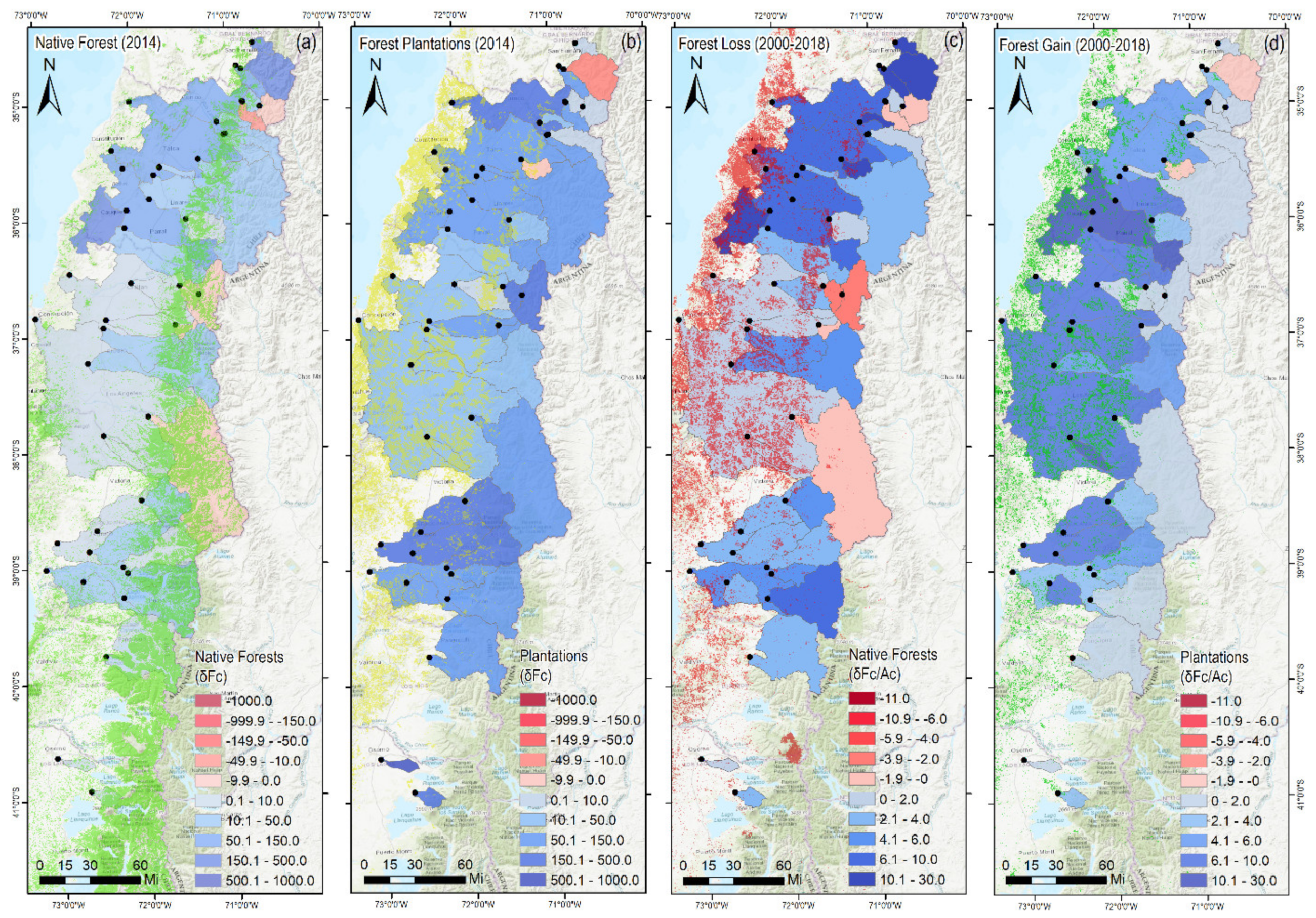
2.2. Land Use of the Mediterranean-Climate (MC) Catchments

Land use for each catchment was provided by CONAF, through a compilation of several of their National Forest Inventories carried out discontinuously between 1997 and 2016. The eight classification categories defined by CONAF are: native forest, meadows and bushes, mosaic, agricultural areas, forest plantations, urban areas, lakes and rivers, and other uses. However, for the purposes of this study we used the following re-classified categories. (1) Native forest (NF): areas in which native trees have canopy coverage over 25% of the land. It includes adult, renewal forests (secondary young forests), adult-renewal, and scrub forests; (2) forest plantations (FP): areas dominated by exotic plantations, mostly Pinus radiata and Eucalyptus spp., established to supply the forestry industry and, to a lesser extent, firewood; and (3) other land uses: all areas not included in the previous categories. The above categories were selected to focus the analysis of our research into the possible differences between native forests and forest plantations. One of the main issues of CONAF inventories is their temporal and spatial discontinuity (see Supplementary Materials, SI), which made the estimation of forest changes over time challenging. This discontinuity issue is also common from remote sensed data due to climate conditions and due to the temporal and spatial resolution of the sensors. However, it is possible that changes at the ecosystem timescales could be small in relation to the catchment sizes and, therefore, not a relevant factor controlling the hydrologic response as compared to the present forest cover of MC catchments, which in fact could be one of the most important features controlling present-day and long-term hydrologic response in MC catchments, as discussed in other sections of this document.

2.3. Classification of Catchments According to Their Forest Cover

The forest cover percent (see Equation (1)) was calculated for each of the 42 catchments under evaluation using Equation (1), where FC is the forest cover (%) estimated using the first and last year of available data for each catchment; AF is the area of total forest cover (including native forests and/or forest plantations) (m2); and AC is the area of the catchment under analysis (m2). All 42 catchments were classified according to their FC value, resulting in 24 categories (groups) shown in Table 2. Only those groups with at least 5 catchments were used for further analyses.
F C = A F A C × 100
It is also important to indicate that the estimation of Fc can be carried out using either imperial or international system units.

2.4. Calculation of Relative Changes in Forest Cover

Temporal relative changes of forest cover were calculated for each of the 42 catchments under study. Relative-to-initial changes of forest cover ( δ F C ) were calculated using Equation (2), and relative-to-catchment changes of forest cover ( δ F C A C ) were calculated using Equation (3). Equation (2) represents the relative change over the initial forested area, whereas Equation (3) represents the relative change of forest cover over the catchment area.
δ F C = A i A i n A i n × 100
δ F C A C = A i A i n A C × 100
In Equations (2) and (3), δ F C is the relative-to-initial forest cover change (%); δ F C / A C is the relative-to-catchment size forest cover change (%); A i is the current (or most recent) area of NF and/or FP (m2); A i n is the previous (or initial) area of NF and/or FP (m2); n is the number of years between initial and current forest cover; and A C is the area of the catchment under analysis (m2).

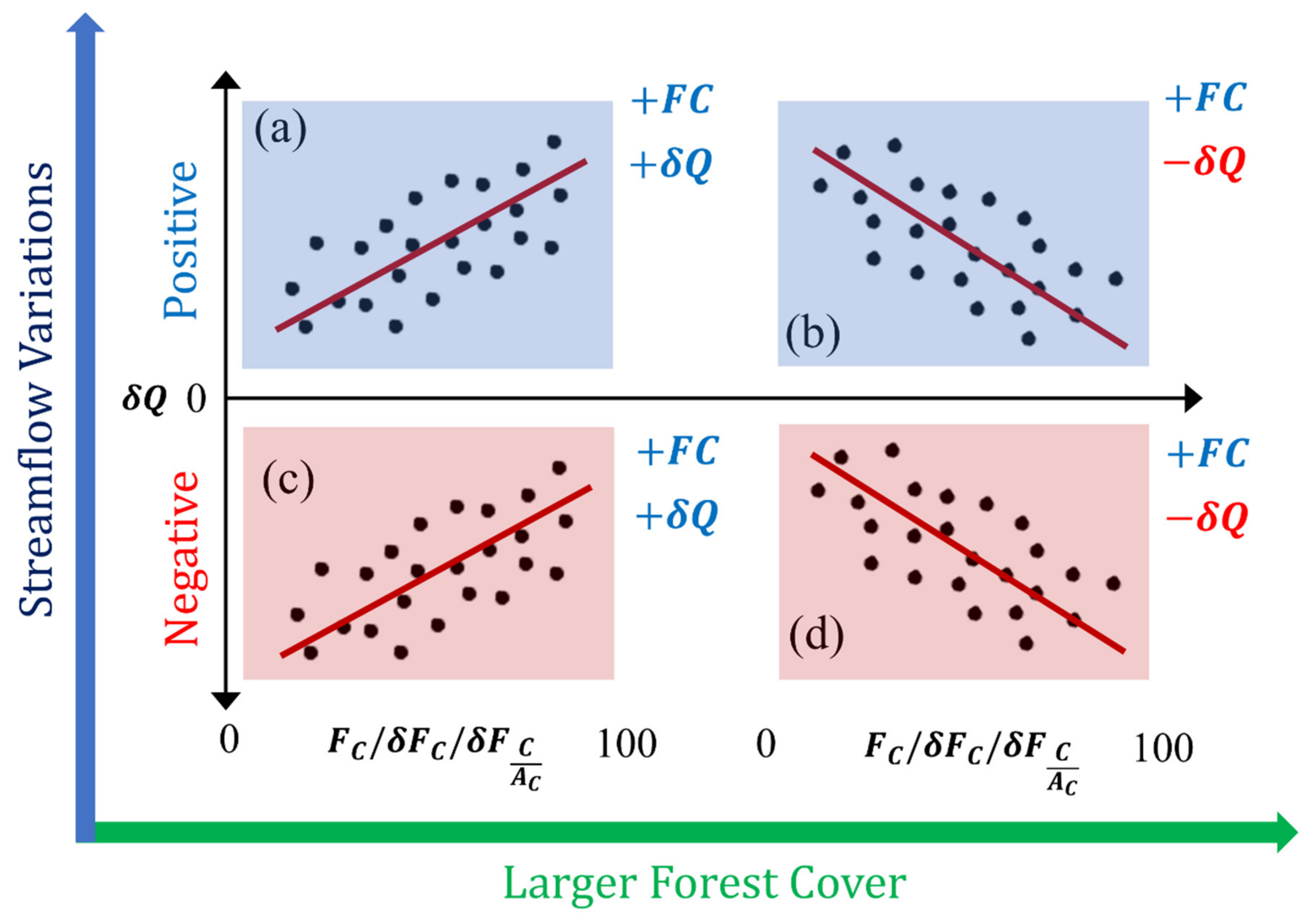
2.5. Long-Term Streamflow Variations versus Forest Cover Dynamics

Average, minimum, and maximum monthly streamflow records over 21 years (1994–2015) were provided for each catchment by the National Directorate of Water (DGA), the Chilean institution officially in charge of monitoring and managing national water resources. To estimate long-term streamflow variations for each group of catchments, the non-parametric Mann–Kendall (MK) and Sen Slope’s statistical tests were applied (see details in Shadmani et al. [77], Valdés-Pineda et al. [33,78], and Sangüesa et al. [79]) for each month within the 1994–2015 period. Additionally, monthly time series were grouped into dry (from October to April) and wet (from April to September) periods, to determine possible differences at the seasonal scale. As a first step, the MK and Sen Slope tests were applied to estimate real and standardized monthly variations of average, minimum, and maximum streamflow (dQ, as observed in Figure 2) for each catchment.

2.6. Intra-Catchment Relationships and Field Significance

The resulting monthly streamflow trends estimated for each catchment were evaluated at the intra-catchment scale to determine empirical relationships between long-term streamflow variations (real and standardized slopes) and the present-day forest cover, or the long-term forest cover change for all the catchments under study. Additionally, a field significance analysis through bootstrapping approach was performed considering 100,000 random selections of forest cover groups (see Table 2 for reference), ranging between 5 and 40 catchments, where the empirical relationship (dQ vs. FC, δ F C   o r   δ F C A C ) was re-evaluated to analyze the field significance of results. Thus, expected relationships between forest cover (%) and long-term streamflow variations (MK’s z values) were plotted, as illustrated in Figure 2.

2.7. Long-Term Variations of Other Hydrological Fluxes

To complement our analysis, we also evaluated the long-term monthly and annual rainfall variations (mm/year) using all available rain gauges managed by DGA. Monthly rainfall variations were additionally calculated using the CHIRPS precipitation dataset [80] to expand the spatial distribution and evaluation of the instrumental rainfall trends.
To consider the fact that many rivers of the Mediterranean catchments in central Chile are fed by snowmelt and glacier melt from the Andes Mountains, long-term monthly variations of snow water equivalent (SWE) were also evaluated using Terraclimate products [81].

3. Results

3.1. Mediterranean-Climate (MC) Ecosystems and Long-Term Forest Cover Changes

The forest cover in the catchments evaluated in this study is highly dominated by native forests (NF). For instance, 88% of the MC analyzed catchments have native forest cover larger than 10%, and about 60% of catchments have native forest cover larger than 20%. On the other hand, 48% of the catchments have forest plantation cover lower than 5%, with only 17% of them having forest cover percent larger than 20%. These classifications confirm the dominance of native forests along the study area. From our results, it was observed that the relative-to-initial forest cover ( δ F C ) changes were mostly positive (i.e., increase in forest cover). For NF, 86% of the catchments showed positive variations of δ F C . These positive variations exceeded up to four times the initial coverage of NF in catchments that showed the most extreme changes (Figure 3a). Positive variations in plantations were observed in practically all the analyzed catchments (95%), with positive changes that exceeded up to nine times the initial cover of FP. The most significant changes in plantations were observed in catchments located in the southern portion of the study area, though significant changes were also observed in Andean catchments in the north-central portion of the study area (Figure 3b). However, and in a smaller proportion, negative variations were observed, especially in Andean or mountainous areas, and the number of catchments with negative variations in either NF or FP was in general lower compared to positive variations (Figure 3a,b).
When the above changes were analyzed relative to the size of the catchments ( δ F C A C ), it was observed that 14% of the catchments revealed positive variations of native forest cover that exceeded 10%. However, most of the catchments revealed positive changes in a range of less than 5%. Similarly, catchments with negative variations of native forest cover remained in a range of less than 4%, relative to the size of the catchment (Figure 3c,d).
Changes of forest cover in plantations revealed only two catchments with positive variations greater than 10% (Damas en Tacamo, and Ñuble en San Fabián, corresponding to catchments 23 and 41 in Figure 1). The dominant pattern observed in 70% of the catchments was positive variations of forest plantation cover ( δ F C A C ) that did not exceed 5% (Figure 3d). The general pattern of positive changes in native forest cover could be associated with re-sprout and growth of previously cleared NF in central Chile. The increase in FP cover, on the other hand, was mainly due to the rise of the forestry industry [82], which increased the areas available for productive growth. Forest cover changes relative to the size of the catchments revealed that the impact of these changes on large-scale MC catchments was relatively low (see Figure 3b,d); however, the lack of continuity of CONAF’s national inventories (the records span several periods and different geographic areas) did not allow for the quantification of consistent forest cover changes throughout the intra-catchment space. Therefore, it was not possible to determine whether these percent changes or the indicators created to represent these changes could be significantly related to the hydrological response of MC catchments. New datasets and evaluations will be required to further evaluate how the long-term forest ecosystem dynamics could be related to the hydrologic dynamics of large-scale MC catchments.

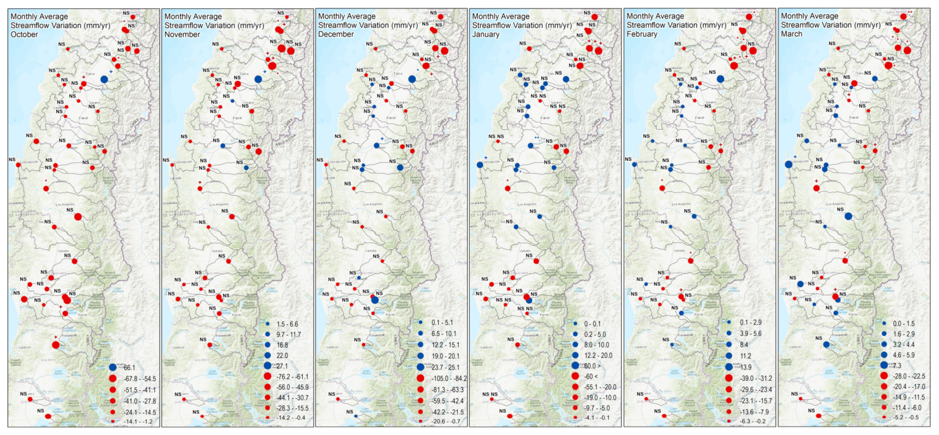
3.2. Long-Term Streamflow Variations within Mediterranean-Climate Catchments

Long-term monthly streamflow variations (mm/month) showed a regional declining trend (Figure 4). Dominant patterns of negative trends were observed during the wet season (April through September), except for August, where 62% of the catchments revealed positive variations in streamflows (see SI). During the dry season (October through March), the pattern of negative trends prevailed in the months of October and November. However, positive trends were observed from December to March in about one third of the catchments, especially those located in the central part of the study area (Figure 4). Despite the existence of these trends in MC catchments, in general, these variations did not represent significant statistical changes. These hydrological variations, while lacking statistical significance, can still be hydrologically significant in the long-term.

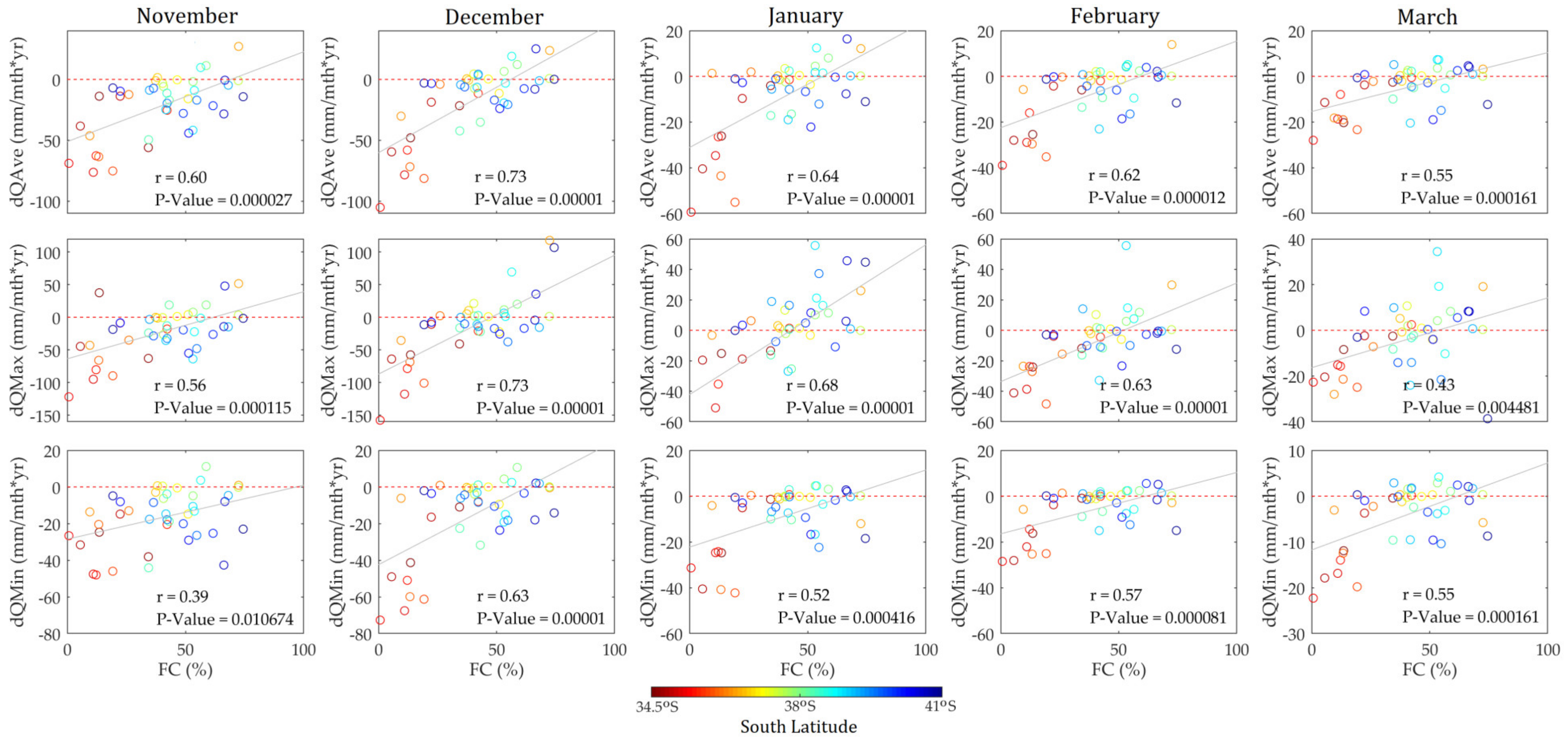
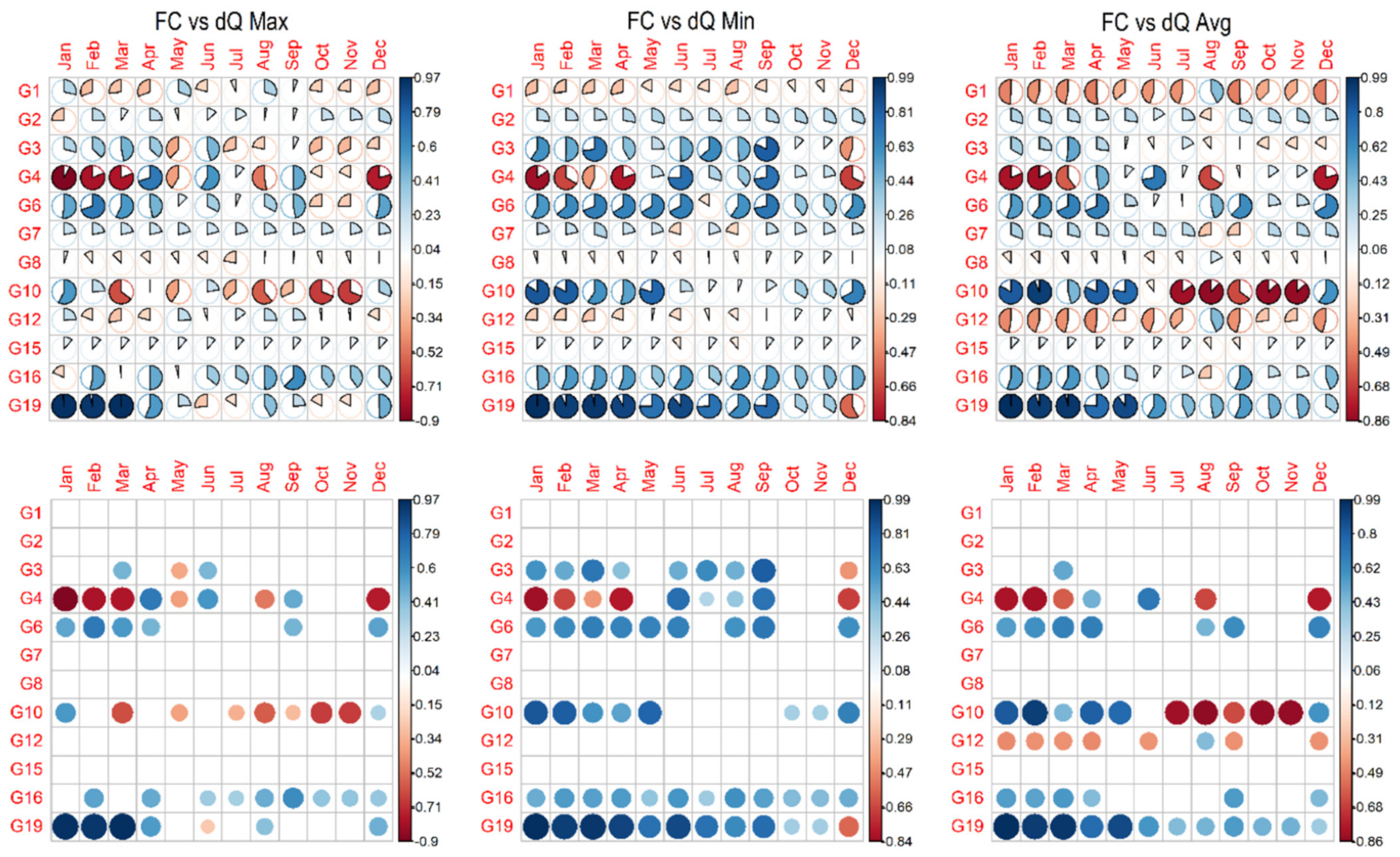
3.3. Forest Cover Dynamics versus Long-Term Streamflow Variations

When streamflow’s temporal variations were related to the catchment forest cover (total, native, or plantation), as well as their respective indicators of relative temporal changes, it was observed that the most consistent relationship occurred between the current total forest cover (i.e., NF and FP together, and “mixed forest”) of the MC catchments and temporal variations of streamflow (1994–2015). This relationship was significant during dry seasons (October through March) and stronger between December and January (Figure 5), with an intra-catchment pattern revealing that the greater the area or fraction of mixed forests with native forest dominance in the MC catchments, the greater the tendency to find increases in average, maximum, and minimum monthly streamflow (Figure 5).
This unique feature representing the hydrologic response could be a clear signal of coevolutive patterns at the ecosystem timescales, in which any other abrupt natural or anthropogenic disturbances of the landscape (i.e., forest fires, tree die-off, deforestation, and land use changes) can affect the hydrologic response at local or catchment scales (Figure 5) (for reference, see [83,84,85,86]). The fact that more native and mixed forests are present in an MC catchment could increase the infiltration capacity of soils and the capacity of the catchment to regulate subsurface flow, whose release to the main streamflow of these rivers starts between August and September, when the catchments are still under near-saturated water conditions, and it can be sustained until the end of summer in February, March or even April in some very wet years.
Furthermore, estimates of the monthly mean contribution of glaciers to streamflow in central Chile has shown to be between 40 and 80% [87]. This suggests that there is about 20 to 60% of the total streamflow that can be probably explained by a combination of subsurface flow and melting of low-density snow in the Andes during spring seasons. Towards the summer, subsurface flow is mainly contributed from forest masses and slowly released during the spring and austral summer. This lesser understood source of subsurface flow in MC catchments can represent an important contribution to total streamflow during dry seasons.
An important component of our study was that the forest cover was calculated from CONAF forest inventories. Therefore, all analysis and results provided by this study were calculated using data between 1997 and 2016, for most catchments. A notable limitation of these inventories is that there was no consistency in relation to a fixed period of analysis, and the periods used to calculate the relative changes varied between 3 and 20 years, depending on the catchment. Despite these inconsistencies within the dataset, it was observed that the relative-to-catchment size forest cover change ( δ F C A C ) was a better indicator of long-term hydrological responses, compared to the relative-to-initial forest cover change ( δ F C ). Nevertheless, because these relative forest changes are still very small compared to the size of the catchments (generally lower than 5%), we hypothesize that a critical threshold of total forest reduction or total forest replacement has not yet been reached on the MC catchments. As a consequence, this is a matter of further research to better identify and analyze critical forest cover thresholds influencing summer streamflow response.

3.4. Disaggregation between Groups of Native Forests (NF) and Forest Plantations (FP)

The classification of forest cover percent allowed only those groups with at least five catchments to be evaluated (see Table 2). Results revealed a strong and significant relationship between those catchments with mid-to-high (>15%) native forest cover, combined with low-to-mid (5–15%) FP cover, vs. the long-term variation of streamflow. These catchments represent 50% of the total number of catchments analyzed in this study (groups 16 and 19) (Figure 6), having a total forest cover of at least 20%, with large dominance of NF (see SI for details). Results also suggest that relative changes in groups dominated by FP (group 4) had significant negative relationships during dry months (December through March), that sometimes become positive during winter months (Figure 6) (see SI for details). Additionally, FP showed less positive Sen’s slopes than NF. However, these results need to be considered with caution, since the number of catchments with large forest cover plantation is limited. In this regard, the aggregation of both species into mixed forests showed the strongest intra-catchment relationship, suggesting that further research will be required to capture the specific characteristics, differences, and thresholds between native and forest plantations to understand how these masses evolve at ecosystems timescales, and how they can impact the long-term hydrologic response at the catchment scale.

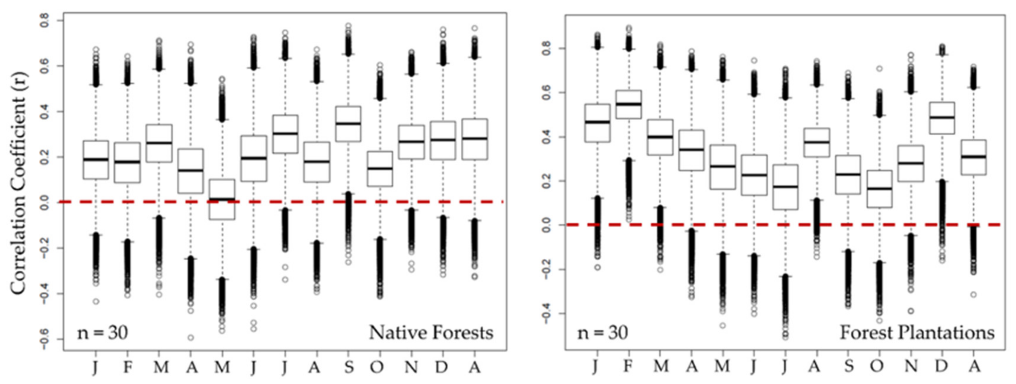
3.5. Field significance: Bootstrapping Analysis

The field significance analysis applied to all catchments evaluated in this study revealed that the relationship between present-day mixed forest cover (the sum of both native forest and FP, as previously mentioned) and long-term variations of streamflow tends to be positive. The bootstrapping generated the empirical distribution of the correlation coefficient obtained for all possible groups of catchments used to establish the intra-catchment relationships. This analysis allowed the identification of the confidence intervals for this empirical relationship. Results revealed that, during dry months, the contribution of water regulated by MC catchments with larger native-dominant mixed forested areas (NF and FP) seems to be generally more significant than the contribution of water that is regulated during winter (see example in Figure 7, considering 30 catchments). These results were consistent for forest cover groups that considered 5, 10, 20, 30, and 40 catchments with the caveat that the area occupied by FP is low in most of the catchments under study. Therefore, as previously stated, the outcomes of this analysis must be summited to further research to establish stronger conclusions about the specific differences between NF and FP under paradigms of catchment coevolution at ecosystem timescales.

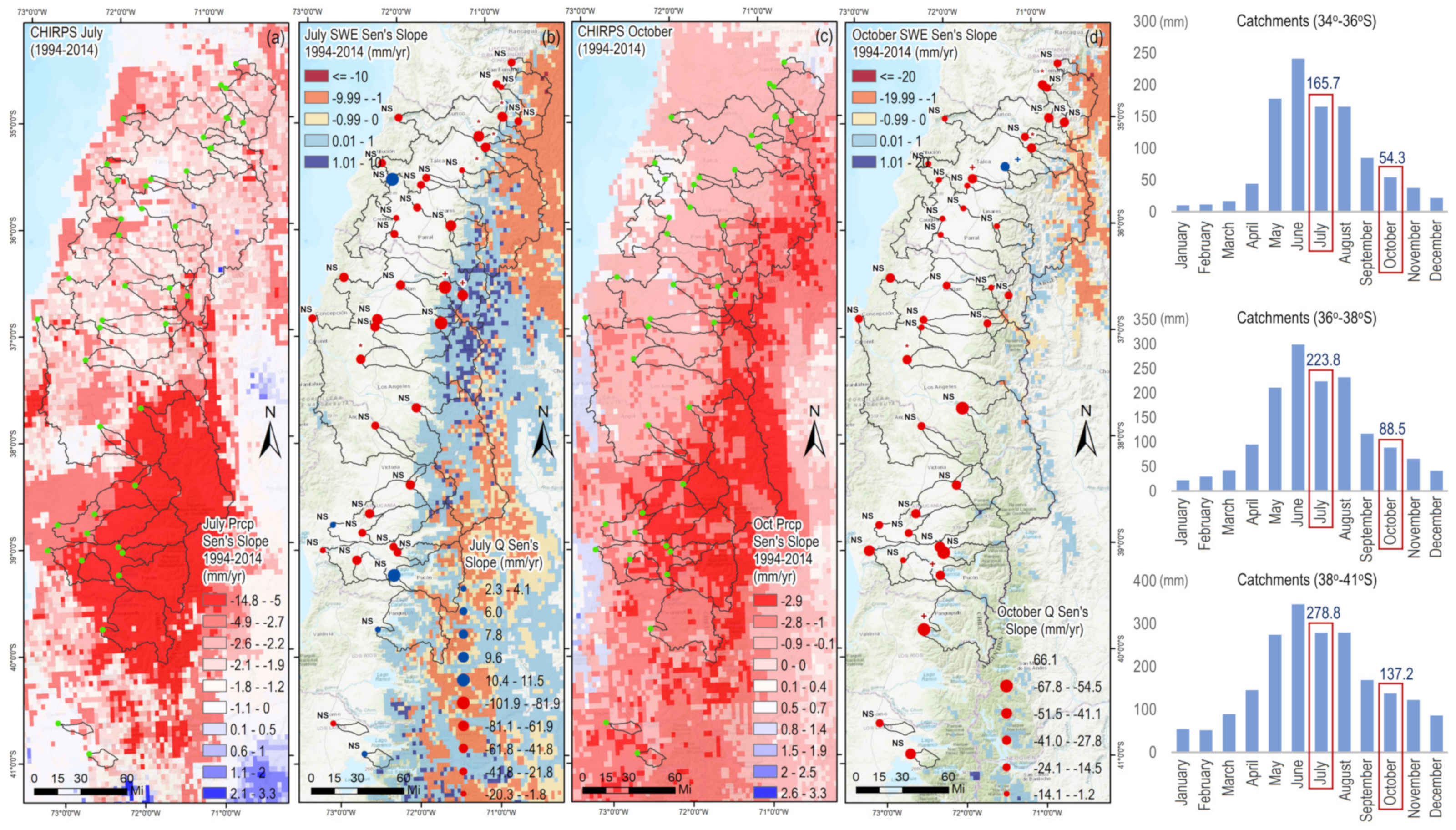
3.6. Influence of Precipitation and Snow Water Equivalent on Total Streamflow

Monthly rainfall accumulation between 1994 and 2014 revealed a mesoscale pattern of negative catchment-averaged trends during the months of April, June, July (see Figure 8a), September, and October (see Figure 8c). The strongest catchment-averaged decreases in rainfall accumulation ranged between 4 and 6 mm during April (fall season), especially in catchments located in the southern portion of the study area. During winter months (June and July), these reductions reached up to more than 10 mm in the most extreme cases over the same group of catchments. At the beginning of spring (September and October), regional rainfall accumulation showed reductions between 2 and 4 mm, which are an important loss of water for the reactivation of secondary subsurface peak flows developed during those months. In fact, spring storms can define how long the snow will last and the subsurface contribution of flow that is regulated from forest masses and released later during spring and summer seasons from the MC catchments. Additionally, it is important to add that the instrumental records of annual precipitation accumulation (130 rain gauges distributed within central Chile) also revealed regional declines, reaching up to more than 50 mm in the most noticeable situations. Those records also confirmed that rain gauges located at higher elevations have experienced more negative variations than those located on lower lands. The spatial distribution of those temporal variations (1994–2014), but especially the fact that they are more negative towards the Andes, also affects (and will affect) the availability of water on the headwaters of the MC catchments.
Furthermore, the negative variations in streamflow (see Figure 5) observed for several MC catchments during summer months (October through March) are also explained by negative changes in the availability of snow and glacial water during winter and spring months. For instance, the snow water equivalent (SWE) available from the Andes Mountain range decreased regionally in the Andes during July and October months (Figure 8a,c). However, these reductions do not span the whole study area, since positive changes were also noticeable in some central catchments (Figure 8b,d). Despite the above, both positive and negative catchments average SWE variations ranged between 0 and 3 mm, which is about three times lower than the variations observed for precipitation accumulation. These differences also put in evidence that snowmelt processes occur at a slower rate than precipitation processes. During spring and summer periods, slight long-term negative catchment-averaged SWE variations (≤1 mm) were observed in most of the catchments under study. On the other hand, a few catchments with slight positive variations were also observed (≤1 mm). In general, the SWE catchment-averaged results revealed that regional variations in spring are not as hydrologically significant as catchment-averaged precipitation (in terms of millimeters of water lost over time). Those results can be explained by the spatial distribution of snowfall, which occurs mostly in the Andes and its foothills. Therefore, there are many catchments that are snow fed (from upper catchments), but do not have direct snow accumulation during autumn or winter seasons.
Despite the observed negative long-term changes in rainfall (especially during April, June, and July) and negative SWE variations (specifically between August and December), the glacier melting component (not evaluated in this study) has also experienced negative variations in central Chile (see for reference [88,89,90,91,92]). These components are in fact the main controlling factors of MC Andean rivers. However, they do not explain the total seasonal or annual variation of streamflow on these catchments.
The presence of a significant positive intra-catchment relationship found in this study confirms that long-term increases in streamflow are related to the area of native-dominant forests present in the MC basins. For instance, in most of the MC catchments evaluated in this study, the snow and glacier flow component could be separated from subsurface flows, since the latter component is strongly replenished by rainfall storms that occur during winter and spring seasons, and then regulated and slowly released by forest masses located on mid-elevation hillslopes during spring and summer months. This separation of hydrological components is in fact driven by the elevational differences of the MC catchments, since some of them are located at lower elevations in the central valley and the Andean foothills. A few other catchments span the whole east-to-west domain from the Andes to the Pacific Ocean, and these are controlled by a wide diversity of hydrological processes affecting total streamflow.

4. Discussion

This study provides a novel intra-catchment relationship between a unique vegetative catchment forming factor and the long-term hydrologic response observed in Mediterranean catchments of central Chile. The empirical relationship was established from a group of 42 large-scale catchments with areas >20,000 ha that were evaluated using long-term streamflow records, as well as the evolution of forests at ecosystem timescales. Our results revealed significant intra-catchment relationships between the forest cover (estimated relative to each catchment’s area) and the long-term variation of streamflow (observed at each catchment’s outlet). Significant linear correlations were found mainly during the dry season, suggesting that catchments with larger forest cover have a positive effect on the long-term contribution of monthly minimum, average, and maximum streamflow. This empirical relationship is sustained by the hypothesis that most water falling into the ground in forested catchments tends to have slow passage through the surface of the slope, given the physical obstacles (e.g., litter and organic matter) that can reduce the surface runoff component of the hydrologic partition (e.g., [93]). Since forests with native dominance provide better moisture retention conditions in the soil–vegetation complex, the infiltration capacity of rainwater and the deep percolation increases during the rainy season. This process starts in high areas of the catchment, and then promotes regional groundwater table recharge along preferential flow paths of subsurface flow towards low areas of the catchment [94]. The hydraulic load of water in the forest-dominated hillslopes of Mediterranean catchments is generally released as springs or small creeks along the main gullies of the sub-basins. This process can last up to several months into the summer season (December to March). Therefore, it is interesting how this pattern was significantly revealed during summer months, where the empirical intra-catchment relationship revealed that the rate of streamflow change over time was generally more positive on catchments with larger forest cover dominated by native species, which clearly demonstrates that forested Mediterranean catchments fulfill this role.
In this regard, it is well-known that forested catchments play an important role in the distribution of precipitated water, because tree canopies can intercept a significant portion of rainfall [95]. Similarly, a proportion of the intercepted water is returned to the atmosphere by evaporation, and the tree balance is closed with water that reaches the ground as precipitation from foliage [96,97] and as storm runoff from stems and trunks [98]. Additionally, the litter layer, the organic matter, and other inert materials are an important obstacle to the passage of surface runoff during storms (e.g., [99]), representing a greater possibility of rainwater infiltration into the ground [94]. In summary, the hydrological processes observed at the tree scale suggest that the residence time of surface and subsurface water traveling in forested catchments is longer compared to non-forested catchments, and the intra-catchment relationship found in this study clearly reveals that pattern [94,100,101].
In addition to what is mentioned above, it is important to indicate that the evaluation of the most extreme situations (MC catchments with native forests cover larger than 40% and forest plantations cover larger than 40%) revealed clear and significant intra-catchment relationships during summer months (November through March). For instance, patterns of positive variations in monthly streamflow (average, maximum, and minimum) were only observed for the catchments with dominance of native forests. Catchments dominated by forest plantations, on the other hand, showed a generally negative impact on monthly summer flows, although this is debatable since the basins in general presented very low PF coverage, and it is necessary to have a greater number of basins with higher values of PF coverage. The above is confirmed because this observed influence seemed to dissipate when we evaluated catchments with lower plantation coverage mixed with native forests areas, observing that there could still be positive variations of summer flows in response to greater mixed forested areas. This finding reveals the plausible existence of a critical threshold of plantation coverage allowable at the catchment scale, which could still favor the regulation and hydrological response of the MC catchments under conditions that allow maintaining the long-term water balance of the whole hydrologic system. This is important for the development of forest productive schemes in terms of knowing or predicting what sustainable forest cover of plantations is needed to maintain or increase large-scale and long-term water production. Obviously, it is still necessary to determine in greater detail how these thresholds could vary in space and time, meaning that future experimental research should establish baselines to improve this understanding. In the same context, it is important to add that previous research on these topics has mainly focused on testing the two-water world hypothesis concluding that trees in Mediterranean climates capture water from micropores of the soil (static water), leaving surface runoff and subsurface flow (moving water) circulating by gravity [102,103]. In the same context, Hervé et al. [104] concluded that the source of water used by trees in two catchments of south-central Chile (one with NF and the second one with eucalyptus plantations), comes from micropores of the soil. Furthermore, the authors additionally found that in winter, fresh rainwater replenishes the micropores, and that water is also used by both tree species.
Other empirical studies carried out in Mediterranean catchments have shown that the increase in forest plantations could have negative effects on annual flows in catchments greater than 20,000 hectares [44]. Similarly, Little et al. [38] analyzed two catchments of central Chile, concluding that FPs have a negative effect on surface water production. However, the linear modeling used and the low number of basins in the study lead to a limited range of conclusions that cannot be expanded to all MC catchments.
Future research needs to focus on improving the understanding of the effects of catchments dominated by native forests and forest plantations in the long-term hydrological response. Since our results are also limited by the lack of consistent records for all catchments under analysis, this new understanding will require additional efforts of the Chilean government in terms of data generation and monitoring across different spatial and temporal scales, promoting the diversity of tree species for further evaluation and developing policies that can benefit the long-term natural hydrological cycles of MC catchments.

5. Conclusions and Recommendations

Results from this study allowed us to establish the first empirical intra-catchment relationship between forest cover in Mediterranean catchments of central Chile and long-term variations of monthly river streamflow (average, maximum, and minimum). This relationship is positive, meaning that a larger forest cover of native dominant-type can increase long-term streamflow variations.
The central conclusion based on data from 42 large catchments is that the greater the area of a catchment covered with mixed forests dominated by native species, the larger the long-term subsurface flow production at the catchment scale, especially during the dry season (summer months).
Though rainfall in the study area occurs mainly during winter months (when vegetation is dormant, with minimal water consumption), and it also decreased over the same time span, forested areas have shown to have a positive impact on the regulation of river flows, most likely because of enhanced infiltration processes during the rainy season (winter), thus promoting a subsurface flow component during the spring and summer seasons.
In summary, mixed forest cover with dominance of native ecosystems was by far the strongest indicator of the long-term hydrologic response evaluated over the streamflow variations at the catchment’s outlets. Our analysis confirmed that increases in summer streamflow from the release of subsurface flow in Mediterranean catchments are significantly associated with the presence of native-dominant forests. This analysis should be complemented by additional research to determine the critical thresholds that enable sustainable hydrological responses that are regulated by forests species at a catchment scale. Such research must be completed with analyses that include more information about soil types, geology, and geomorphology, since it has also been observed that close relationships exist between the hydrological response and the catchment’s morphologic features, e.g., [105,106].
We hypothesize that hydrological responses at ecosystem timescales will have an important impact in future global warming scenarios, where the degradation of forest ecosystems may exacerbate the predicted significant decrease of streamflows, resulting in a decreased availability of natural sources of water for future generations.

Supplementary Materials

The following supporting information can be downloaded at: https://www.mdpi.com/article/10.3390/su14084443/s1, Table S1: Surface (km2) occupied by native forests (temporal evolution). Table S2: Surface (km2) occupied by forest plantations (temporal evolution).

Author Contributions

Conceptualization: R.P., R.V.-P. and P.A.G.-C.; methodology: R.P., A.I., R.V.-P. and P.A.G.-C.; software: R.V.-P. and A.I.; validation: R.V.-P.; formal analysis: R.V.-P., A.I., M.C. and J.P.; investigation: R.P., R.V.-P., P.A.G.-C. and A.I.; resources: R.P.; data curation: R.V.-P., A.I. and P.U.; writing—original draft preparation: R.P., R.V.-P., P.A.G.-C. and A.I.; writing—review and editing: D.F.S., D.G.N. and J.E.M.; visualization: R.P. and R.V.-P.; supervision: R.P.; project administration: R.P. All authors have read and agreed to the published version of the manuscript.

Funding

This research received no external funding.

Institutional Review Board Statement

Not applicable.

Informed Consent Statement

Not applicable.

Data Availability Statement

Most data used in this study can be found at DGA’s, DMC’s and CONAF websites (www.dga.cl, www.dmc.cl, and www.conaf.cl, all accessed on 1 June 2021).

Acknowledgments

The authors deeply thank ANID BASAL FB210015, and the support of Claudia Sangüesa, Francisco Balocchi, Carlos Vallejos, Romina Mendoza, and Alejandra Bernal.

Conflicts of Interest

The authors declare no conflict of interest.

References

  1. Feng, Q.; Dong, S.; Duan, B. The Effects of Land-Use Change/Conversion on Trade-Offs of Ecosystem Services in Three Precipitation Zones. Sustainability 2021, 13, 13306. [Google Scholar] [CrossRef]
  2. Brouillard, B.M.; Dickenson, E.; Mikkelson, K.M.; Sharp, J.O. Water quality following extensive beetle-induced tree mortality: Interplay of aromatic carbon loading, disinfection byproducts, and hydrologic drivers. Sci. Total Environ. 2016, 572, 649–659. [Google Scholar] [CrossRef] [PubMed] [Green Version]
  3. Mikkelson, K.; Bearup, L.; Navarre-Sitchler, A.; McCray, J.; Sharp, J. Changes in metal mobility associated with bark beetle-induced tree mortality. Environ. Sci. Processes Impacts 2014, 16, 1318–1327. [Google Scholar] [CrossRef] [PubMed]
  4. Mikkelson, K.; Bearup, L.; Maxwell, R.; Stednick, J.; McCray, J.; Sharp, J. Bark beetle infestation impacts on nutrient cycling, water quality and interdependent hydrological effects. Biogeochemistry 2013, 115, 1–21. [Google Scholar] [CrossRef]
  5. Mikkelson, K.; Dickenson, E.; McCray, J.; Maxwell, R.; Sharp, J. Adverse water quality impacts from climate-induced forest die-off. Nat. Clim. Change 2013, 3, 218–222. [Google Scholar] [CrossRef]
  6. Pizarro, R.; Garcia-Chevesich, P.; Pino, J.; Ibáñez, A.; Pérez, F.; Flores, J.; Sharp, J.; Ingram, B.; Mendoza, R.; Neary, D.; et al. Stabilization of stage-discharge curves following the establishment of forest plantations: Implications for sediment production. River Res. Appl. 2020, 36, 1828–1837. [Google Scholar] [CrossRef]
  7. Reyna, T.; Garcia-Chevesich, P.; Neary, D.G.; Scott, D.F.; Benyon, R.G.; Reyna, S.M.; Lábaque, M.; Amani, C.; Pizarro, R.; Iroumé, A.; et al. Forest Management and the Impact on Water Resources: A Review of 13 Countries; United Nations Educational, Scientific and Cultural Organization (UNESCO): Paris, France, 2017; p. 204. [Google Scholar]
  8. Bosch, J.; Hewlett, J. A review of catchment experiments to determine the effect of vegetation change on water yield. J. Hydrol. 1982, 55, 3–23. [Google Scholar] [CrossRef]
  9. Andréassian, R. Water and forest: From historical controversy to scientific debate. J. Hydrol. 2004, 291, 1–27. [Google Scholar] [CrossRef]
  10. McCulloch, J.; Robinson, M. History of forest hydrology. J. Hydrol. 1993, 150, 189–216. [Google Scholar] [CrossRef]
  11. Zhang, L.; Dawes, W.; Walker, G. Response of mean annual evapotranspiration to vegetation changes at catchment scale. Water Resour. Res. 2001, 37, 701–708. [Google Scholar] [CrossRef]
  12. Xiao, Q.; Mcpherson, E.; Ustin, S. A new approach to modeling tree rainfall interception. J. Geophys. Res. 2000, 105, 29173–29188. [Google Scholar] [CrossRef] [Green Version]
  13. Calder, I.; Reid, I.; Nisbet, T.; Green, J. Impact of lowland forests in England on water resources: Application of the Hydrological Land Use Change (HYLUC) model. Water Resour. Res. 2003, 39, 1319. [Google Scholar] [CrossRef]
  14. Van Dijk, A.I.; Keenan, R.J. Planted forests and water in perspective. For. Ecol. Manag. 2007, 251, 1–9. [Google Scholar] [CrossRef]
  15. Benyon, R.; Theiveyanathan, S.; Doody, T. Impacts of tree plantations on groundwater in south-eastern Australia. Aust. J. Bot. 2006, 397, 181–192. [Google Scholar] [CrossRef]
  16. Keenan, R.; Gerrand, A.; Nambiar, S.; Parsons, M. Plantation and Water: Plantation Impacts on Streamflow; Science for Decision Makers, Bureau of Rural Sciences: Canberra, ACT, Australia, 2017.
  17. Beets, P.; Oliver, G. Water use by managed stands of Pinus radiata, indigenous podocarp/hardwood forest, and improved pasture in the central north island of New Zealand. New Zealand J. For. Sci. 2006, 37, 306–323. [Google Scholar]
  18. Vertessy, R.; Watson, F.; O’Sullivan, S. Factor determining relations between stand age and catchment water balance in mountains ash forest. For. Ecol. Manag. 2001, 143, 13–26. [Google Scholar] [CrossRef]
  19. Brown, A.; Zhang, L.; McMahon, T.; Western, W.; Vertessy, R. A review of paired catchment studies for determining changes in water yield resulting from alterations in vegetation. J. Hydrol. 2005, 310, 28–61. [Google Scholar] [CrossRef]
  20. Cornish, P.; Vertessy, R. Forest age-induced changes in evapotranspiration and water yield in a eucalypt forest. J. Hydol. 2001, 242, 43–63. [Google Scholar] [CrossRef]
  21. Maier, C.; Albaugh, T.; Cook, R.; Hall, K.; McInnis, D.; Johnsen, K.; Johnson, J.; Rubilar, R.; Vose, J. Comparative water use in short-rotation Eucalyptus benthamii and Pinus taeda trees in the Southern United States. For. Ecol. Manag. 2017, 397, 126–138. [Google Scholar] [CrossRef] [Green Version]
  22. Whitehead, D.; Kelliher, F. Modeling the water balance of a samll Pinus radiata catchment. Tree Physiol. 1991, 9, 17–33. [Google Scholar] [CrossRef]
  23. Oyarzún, C.; Huber, A. Balance hídrico en plantaciones jóvenes de Eucalyptus globulus y Pinus radaiata en el sur de Chile. Terra 1999, 17, 35–44. [Google Scholar]
  24. Huber, A.; Iroumé, A.; Mohr, C.; Frêne, C. Efecto de las plantaciones de Pinus radiata y Eucalyptus globulus sobre el recurso agua en la cordillera de la costa región del Biobío, Chile. Bosque 2010, 31, 219–230. [Google Scholar] [CrossRef]
  25. Farley, K.; Jobbágy, E.; Jackson, R. Effects of afforestation on water yield: A global synthesis with implications for policy. Glob. Change Biol. 2005, 11, 1565–1576. [Google Scholar] [CrossRef]
  26. Scott, D. On the hydrology of industrial timber plantations. Hydrol. Processes 2005, 19, 4203–4206. [Google Scholar] [CrossRef]
  27. United States Department of Agriculture (USDA). Effects of Forest Practices on Peak Flows and Consequent Channel: A State-of- Science Report for Western Oregon and Washington; General Technical Report: PNW-GTR-760; United States Department of Agriculture (USDA): Washington, DC, USA, 2010; 76p.
  28. Lane, P.; Best, A.; Hickel, K.; Zhang, L. The response of flow duration curves to afforestation. J. Hydrol. 2005, 310, 253–265. [Google Scholar] [CrossRef]
  29. Best, A.; Zhang, L.; McMahon, T.; Western, A.; Vertessy, R. A Critical Review of Paired Catchment Studies with Reference to Seasonal Flows and Climatic Variability; CSIRO land and water technical report 25/03; CSIRO: Canberra, ACT, Australia, 2003. Available online: https://publications.csiro.au/rpr/download?pid=procite:fcdfd12f-dca1-41c0-85ce-d06d0c542e7c&dsid=DS1 (accessed on 3 March 2021).
  30. Cannel, M. Environmental impacts of forest monocultures: Water use, acidification, wildlife conservation, and carbon storage. New For. 1999, 17, 239–262. [Google Scholar] [CrossRef]
  31. Schwärzel, K.; Zhang, L.; Montanarella, L.; Wang, Y.; Sun, G. How afforestation affects the water cycle in drylands: A process-based comparative analysis. Glob. Change Biol. 2019, 26, 944–959. [Google Scholar] [CrossRef] [Green Version]
  32. Troch, P.; Lahmers, T.; Meira, A.; Mukherjee, R.; Pedersen, J.; Roy, T.; Valdés-Pineda, R. Catchment coevolution: A useful framework for improving predictions of hydrological change? Water Resour. Res. 2015, 51, 4903–4922. [Google Scholar] [CrossRef]
  33. Valdés-Pineda, R.; Pizarro, R.; Garcia-Chevesich, P.; Valdés, J.; Pérez, F.; Olivares, C.; Vera, M.; Balocchi, F.; Vallejos, C.; Fuentes, R.; et al. Water Governance in Chile: Availability, Management, and Climate Change. J. Hydrol. 2014, 519, 2538–2567. [Google Scholar] [CrossRef]
  34. Keppeler, E.; Ziemer, R. Logging effects on streamflow: Water yield and summer low flows at caspar creek in northwestern California. Water Resour. Res. 1990, 26, 1669–1679. [Google Scholar] [CrossRef]
  35. Iroumé, A.; Huber, A.; Schulz, K. Summer flows in experimental catchments with different forest covers, Chile. J. Hydrol. 2005, 300, 300–313. [Google Scholar] [CrossRef]
  36. Iroumé, A.; Mayen, O.; Huber, A. Runoff and peak response to timber harvest and forest age in southern Chile. Hydrol. Processes 2006, 20, 37–50. [Google Scholar] [CrossRef]
  37. Iroumé, A.; Palacios, H.; Bathurst, J.; Huber, A. Escorrentías y caudales máximos luego de la cosecha a tala rasa y del establecimiento de una nueva plantación en una cuenca experimental del sur de Chile. Bosque 2010, 31, 117–128. [Google Scholar] [CrossRef]
  38. Little, C.; Lara, A.; McPhee, J.; Urrutia, R. Revealing the impacts of forest exotic plantations on water yield in large scale watersheds in south-central Chile. J. Hydrol. 2009, 374, 162–170. [Google Scholar] [CrossRef]
  39. Pizarro, R.; Araya, S.; Jordán, C.; Farías, C.; Flores, J.; Bro, P. The effects of changes in vegetative cover on river flows in the Purapel river basin of central Chile. J. Hydrol. 2006, 327, 249–257. [Google Scholar] [CrossRef]
  40. Lara, A.; Little, C.; Urrutia, R.; McPhee, J.; Álvarez-Garretón, C.; Orazún, C.; Soto, D.; Donoso, P.; Nahuelhual, L.; Pino, M.; et al. Assessment of ecosystem services as an opportunity for the conservation and management of native forests in Chile. For. Ecol. Manag. 2009, 258, 415–424. [Google Scholar] [CrossRef]
  41. Birkinshaw, S.; Bathurst, J.; Iroumé, A.; Palacios, H. The effect of forest cover on peak flow and sediment discharge—An integrated field and modelling study in central–southern Chile. Hydrol. Processes 2011, 25, 1284–1297. [Google Scholar] [CrossRef]
  42. Iroumé, A.; Palacios, H. Afforestation and changes in forest composition affect runoff inlarge river basins with pluvial regime and Mediterranean climate, Chile. J. Hydrol. 2013, 15, 113–125. [Google Scholar] [CrossRef]
  43. Soto-Schönherr, S.; Iroumé, A. How much water do Chilean forests use? A review of interception losses in forest plot studies. Hydrol. Processes 2016, 30, 4674–4686. [Google Scholar] [CrossRef]
  44. Alvarez-Garreton, C.; Lara, A.; Boisier, J.; Galleguillos, M. The Impacts of Native Forests and Forest Plantation on Water Supply in Chile. Forests 2019, 10, 473. [Google Scholar] [CrossRef] [Green Version]
  45. Benyon, R.; Doody, T. Water Use by Tree Plantations in South East South Australia; Technical Report N°148; CSIRO Forestry and Forest Products: Mt. Gambier, SA, USA, 2004. Available online: https://publications.csiro.au/rpr/pub?pid=procite:b06215c8-60bb-4118-9045-fc2bd027d70f (accessed on 10 July 2021).
  46. Bosch, J.; Smith, J. A review of catchment experiments to determine the effect of vegetation changes on water yield and evapotranspiration. J. Hydrol. 1989, 55, 3–23. [Google Scholar] [CrossRef]
  47. Sikka, A.; Samra, J.; Sharda, V.; Samraj, P.; Lakshmanan, V. Low flow and high flow responses to converting natural grassland into bluegum (Eucalyptus globulus) in Nilgiris watersheds of South India. J. Hydrol. 2003, 270, 12–26. [Google Scholar] [CrossRef]
  48. Buytaert, W.; Iñiguez, V.; Bièvre, B. The effects of afforestation and cultivation on water yield in the andean páramo. For. Ecol. Manag. 2007, 251, 22–30. [Google Scholar] [CrossRef]
  49. Cornish, P. The effects of logging ad forest regeneration on water yields in a moist eucalypt forest in New South Wales, Australia. J. Hydrol. 1993, 150, 301–322. [Google Scholar] [CrossRef]
  50. Fahey, B.; Jackson, R. Hydrological impacts of converting native forests and grasslands to pine plantations, South Island, New Zealand. Agric. For. Meteorol. 1997, 84, 69–82. [Google Scholar] [CrossRef]
  51. Harr, R.; Levno, A.; Mersereau, R. Streamflow changes after logging 130-year-old Douglas fir in two small watershed. Water Resour. Res. 1982, 18, 637–644. [Google Scholar] [CrossRef] [Green Version]
  52. Hicks, B.; Beschta, R.; Harr, D. Long-term changes in streamflow following logging in western Oregon and associated fisheries implications. Water Resour. Bull. 1991, 27, 217–226. [Google Scholar] [CrossRef]
  53. Hudson, J.; Crane, S.; Blackie, J. The Plynlimon water balance 1969–1995: The impact of forest moorland vegetation on evaporation and streamflow in upland catchment. Hydrol. Earth Syst. Sci. 1997, 1, 409–427. [Google Scholar] [CrossRef] [Green Version]
  54. Komatsu, H.; Tanaka, N.; Kume, T. Do coniferous forest evaporate more water than broad-leaved forest in Japan? J. Hydrol. 2007, 336, 361–375. [Google Scholar] [CrossRef]
  55. Scott, D.; Lesch, W. Streamflow responses to afforestation with Eucalyptus grandis and Pinus patula and to felling in the Mokobulaan experimental catchments, South Africa. J. Hydrol. 1997, 199, 360–377. [Google Scholar] [CrossRef]
  56. Swanson, R.; Golding, D.; Rothwell, R.; Bernier, P. Hydrologic Effects Bof Clear-Cutting at Marmot Creek and Streeter Watershed; Alberta Information Report NOR-X-278; Canadian Forestry Service, Northern Forestry Centre: Edmonton, AB, Canada, 1986. Available online: https://research-groups.usask.ca/hydrology/documents/pubs/marmot/swanson_et_al_1986a.pdf (accessed on 3 March 2021).
  57. Waterloo, M.; Schellekens, J.; Bruijnzeel, L.; Rawaqa, T. Changes in catchment runoff after harvesting and burning of Pinus caribaea plantation in Viti Levu, Fiji. For. Ecol. Manag. 2007, 251, 31–44. [Google Scholar] [CrossRef]
  58. Serrano-Muela, P.; Regüés, D.; Lana-Renault, N.; Nadal, E. 2008 Estudio de la trascolación bajo diferentes tipos de cubierta forestal durante el periodo fenológico con hojas en el Pirineo Central Español. In Proceedings of the Trabajos de Geomorfología en España, 2006–2008: X Reunión Nacional de Geomorfología, Cádiz, Spain, 14–19 September 2008. [Google Scholar]
  59. Santoro, C.; Capriles, J.; Gayo, E.; De Porras, M.; Maldonado, A.; Standen, V.; Latorre, C.; Castro, V.; Angelo, D.; McRostie, V.; et al. Continuities and discontinuities in the socio-environmental systems of the Atacama Desert during the last 13,000 years. J. Anthropol. Archeol. 2017, 46, 28–39. [Google Scholar] [CrossRef] [Green Version]
  60. Rech, J.; Quade, J.; Betancourt, J. Late quaternary paleohydrology of the central Atacama desert (lat 22°–24°), Chile. Geol. Soc. Am. Bull. 2002, 114, 334–348. [Google Scholar] [CrossRef]
  61. Carro, L.; Castro, J.; Razmilic, V.; Noiovi, I.; Pan, C.; Igual, J.; Jaspars, M.; Goodfellow, M.; Bull, A.; Asenjo, J.; et al. Uncovering the potential of novel micromonosporae isolated from an extreme hyper-arid Atacama Desert soil. Nat. Sci. Rep. 2019, 9, 4678. [Google Scholar] [CrossRef]
  62. Cowling, R.; Rundel, P.; Lamont, B.; Arroyo, M.; Arianoutsou, M. Plant diversity in Mediterranean-climate regions. Trend Ecol. Evol. 1996, 11, 362–366. [Google Scholar] [CrossRef]
  63. Armesto, J.; Arroyo, M.; Hinojosa, O. The mediterranean environment of central Chile. In The Physical Geography of South America; Oxford Scholarship Online: Oxford, UK, 2007; pp. 184–199. ISBN 9780195313413. [Google Scholar]
  64. Corporación Nacional Forestal de Chole (Conaf). Catastro Vegetacional- Superficies de uso de Suelo Regional. 2017. Available online: https://www.conaf.cl/nuestros-bosques/bosques-en-chile/catastro-vegetacional/ (accessed on 10 May 2021).
  65. Elizalde Mac-Clure, R. La Sobrevivencia de Chile. La Conservación de Sus Recursos Naturales Renovables; Servicio Agrícola y Ganadero, Ministerio de Agricultura: Santiago, Chile, 1958; 492. [Google Scholar]
  66. Zamorano-Elgueta, C.; Rey, M.; Cayuela, L.; Hantson, S.; Armenteras, D. Native forest replacement by exotic plantations in southern Chile (1985–2011) and partial compensation by natural regeneration. For. Ecol. Manag. 2015, 345, 10–20. [Google Scholar] [CrossRef] [Green Version]
  67. Uribe, S.; Estades, C.; Radeloff, V. Pine plantations and five decades of land use change in central Chile. PLoS ONE 2020, 15, e0230193. [Google Scholar] [CrossRef] [Green Version]
  68. Durán, A.; Barbosa, O. Seeing Chile’s forest for the tree plantations. Science 2019, 365, 1388. [Google Scholar] [CrossRef]
  69. Heilmayr, R.; Echeverría, C.; Lambin, E. Impacts of Chilean forest subsidies on forest cover, carbon and biodiversity. Nat. Sustain. 2020, 3, 701–709. [Google Scholar] [CrossRef]
  70. Heymar, R.; Echeverría, C.; Fuentes, R.; Lambin, E. A plantation-dominated forest transition in Chile. Appl. Geogr. 2016, 75, 71–82. [Google Scholar]
  71. Valdés-Pineda, R.; Pizarro, R.; Valdés, J.; Carrasco, J.; García-Chevesich, P.; Olivares, C. Spatio-temporal trends of precipitation, its aggressiveness and concentration, along the Pacific coast of South America (36–49°S). Hydrol. Sci. J. 2016, 61, 2110–2132. [Google Scholar] [CrossRef] [Green Version]
  72. Quintana, J.; Aceituno, P. Changes in the rainfall regime along the extratropical west coast of South America (Chile): 30–43° S. Atmósfera 2012, 25, 1–22. [Google Scholar]
  73. Montecinos, A.; Aceituno, P. Seasonality of the ENSO-Related rainfall variability in Central Chile and associated circulation anomalies. J. Clim. 2003, 16, 281–296. [Google Scholar] [CrossRef] [Green Version]
  74. Falvey, M.; Garreaud, R. Wintertime precipitation episodes in central Chile: Associated meteorological condition and Orographic influences. J. Hydrometeorol. 2007, 8, 171–193. [Google Scholar] [CrossRef]
  75. Viale, M.; Garreaud, R. Orographic effects of the subtropical and extratropical Andes on upwind precipitating clouds. J. Geophys. Res. Atmos. 2015, 120, 4962–4974. [Google Scholar] [CrossRef]
  76. Pizarro, R.; Vera, M.; Valdés, R.; Helwig, B.; Olivares, C. Multi-decadal variations in annual maximum peak flows in semi-arid and temperate regions of Chile. Hydrol. Sci. J. 2014, 59, 300–311. [Google Scholar] [CrossRef] [Green Version]
  77. Shadmani, M.; Marofi, S.; Roknian, M. Trend analysis in reference evapotranspiration using Mann-Kendall and Spearman’s Rho test in arid regions of Iran. Water Resour. Manag. 2012, 26, 211–224. [Google Scholar] [CrossRef] [Green Version]
  78. Valdés-Pineda, R.; Valdés, J.; Diaz, H.; Pizarro-Tapia, R. Analysis of spatio-temporal changes and seasonal precipitation variability in South America-Chile and related ocean-atmosphere circulation patterns. Int. J. Climatol. 2016, 36, 2979–3001. [Google Scholar] [CrossRef]
  79. Sangüesa, C.; Pizarro, R.; Ibañez, A.; Pino, J.; Rivera, D.; García-Chevesich, P.; Ingram, B. Spatial and Temporal Analysis of Rainfall Concentration Using the Gini Index and PCI. Water 2018, 10, 112. [Google Scholar] [CrossRef] [Green Version]
  80. Funk, C.; Peterson, P.; Landsfeld, M.; Pedreros, D.; Verdin, J.; Shukla, S.; Husak, G.; Rowland, J.; Harrison, L.; Hoell, A.; et al. The climate hazards infrared precipitation with stations—A new environmental record for monitoring extremes. Nat. Sci. Data 2015, 2, 150066. [Google Scholar] [CrossRef] [Green Version]
  81. Abatzoglou, J.; Dobrowski, S.; Parks, S.; Hegewisch, K. Terraclimate, a high-resolution global dataset of monthly climate and climatic water balance from 1958–2015. Sci. Data 2018, 5, 170191. [Google Scholar] [CrossRef] [Green Version]
  82. Contesse, D. El Desarrollo Forestal Chileno: Una Realidad Sustentable; SEREPSERVI: Santiago, Chile, 1990; 144p. [Google Scholar]
  83. Guardiola-Claramonte, M.; Troch, P.; Breshears, D.; Huxman, T.; Switanek, M.; Durcik, M.; Cobb, N. Decreased streamflow in semi-arid basins following drought-induced tree die-off: A counter-intuitive and indirect climate impact on hydrology. J. Hydrol. 2011, 406, 225–233. [Google Scholar] [CrossRef]
  84. Nobert, J.; Jeremiah, J. Hydrological response of watershed system to land use/cover change. A case of Wami River basin. Open Hydrol. J. 2012, 6, 78–87. [Google Scholar] [CrossRef]
  85. Balocchi, F.; Flores, N.; Neary, D.; White, D.; Silberstein, R.; Ramírez de Arellano, P. The effect of the ‘Las Maquinas’ wildfire of 2017 on the hydrologic balance of a high conservation value Hualo (Nothofagus glauca (Phil.) Krasser) forest in central Chile. For. Ecol. Manag. 2020, 477, 118482. [Google Scholar] [CrossRef]
  86. Balocchi, F.; Rivera, D.; Arumi, J.; Morgenstern, U.; White, D.; Silberstein, R.; Ramírez de Arellano, P. An Analysis of the Effects of Large Wildfires on the Hydrology of Three Small Catchments in Central Chile Using Tritium-Based Measurements and Hydrological Metrics. Hydrology 2022, 9, 45. [Google Scholar] [CrossRef]
  87. Bravo, C.; Loriaux, T.; Rivera, A.; Brock, B. Assesing glacier melt contribution to streamflow at Universidad Glacier, central Andes of Chile. Hydrol. Earth Syst. Sci. 2017, 21, 3249–3266. [Google Scholar] [CrossRef] [Green Version]
  88. Bown, F.; Rivera, A.; Acuña, C. Recent glacier variations at the Aconcagua basin, central Chilean Andes. Ann. Glaciol. 2008, 48, 43–48. [Google Scholar] [CrossRef] [Green Version]
  89. Le Quesne, C.; Acuña, C.; Boninsegna, J.; Rivera, A.; Barichivich, J. Long-term glacier variations in the Central Andes of Argentina and Chile, inferred from historical records and tree-ring reconstructed precipitation. Palaeogeogr. Palaeoclimatol. Palaeoecol. 2009, 281, 334–344. [Google Scholar] [CrossRef]
  90. Azócar, G.; Brenning, A. Hydrological and geomorphological significance of rock glaciers in the dry Andes, Chile (27–33 S). Permafr. Periglac. Processes 2010, 21, 42–53. [Google Scholar] [CrossRef]
  91. Barcaza, G.; Nussbaumer, S.; Tapia, G.; Valdés, J.; García, J.; Videla, Y.; Albornoz, A.; Arias, V. Glacier inventory and recent glacier variations in the Andes of Chile, South America. Ann. Glaciol. 2017, 58, 166–180. [Google Scholar] [CrossRef] [Green Version]
  92. Ayala, Á.; Farías-Barahona, D.; Huss, M.; Pellicciotti, F.; McPhee, J.; Farinotti, D. Glacier runoff variations since 1955 in the Maipo River basin, in the semiarid Andes of central Chile. Cryosphere 2020, 14, 2005–2027. [Google Scholar] [CrossRef]
  93. López, F. Restauración Hidrológico Forestal de Cuencas y Control de la Erosión; Ediciones Mundi-Prensa; Tragsa y Tragsatec: Madrid, España, 1994; 902p. [Google Scholar]
  94. Vicente, E.; Vilagrosa, A.; Ruiz, S.; Manrique, À.; González, M.; Moutahir, H.; Chirino, E.; del Campo, A.; Bellot, J. Water balance of mediterranean Quercus ilex L. and Pinus halepensis Mill. Forests in semiarid climates: A review in a climate change context. Forests 2018, 9, 426. [Google Scholar] [CrossRef] [Green Version]
  95. Yan, W.; Deng, X.; Chen, X.; Tian, D.; Wenhua, X.; Peng, Y. Long-term variation of rainfall interception in different growth stages of Chinese fir plantation. Hydrol. Sci. J. 2015, 60, 2178–2188. [Google Scholar] [CrossRef]
  96. Navar, J.; Méndez, J.; González, H. Intercepción de la lluvia en especies de leguminosas del nordeste de México. Terra Latinoam. 2008, 26, 61–68. [Google Scholar]
  97. Huber, A.; Iroume, A.; Bathurst, J. Effect of Pinus radiate on water balance in Chile. Hydrol. Processes 2008, 22, 142–148. [Google Scholar] [CrossRef]
  98. Sheng, H.; Cai, T. Influence of rainfall on canopy interception in mixed broad-leaved-korean pine forest in Xiaoxing’ an mountains, Northeastern China. Forest 2019, 10, 248. [Google Scholar]
  99. Garcia-Chevesich, P. Erosion Control and Land Restoration; Outskirts Press: Denver, CO, USA, 2016; 486p. [Google Scholar]
  100. Yu, P.; Wang, Y.; Coles, N.; Xiong, W.; Xu, L. Simulation of runoff changes caused by cropland to forest conversion in the upper Yangtze river region, SW China. PLoS ONE 2015, 10, e0132395. [Google Scholar] [CrossRef]
  101. United Nations Educational, Scientific and Cultural Organization (UNESCO). Antecedentes de la Relación Masa Forestal y Disponibilidad Hídrica en Chile; Regional Bureau for Science in Latin America and the Caribbean, Unesco Office Montevideo: Montevideo, Uruguay, 2019; 38p. [Google Scholar]
  102. Brooks, R.; Barnard, H.; Coulombe, R.; McDonnell, J. Ecohydrologic separation of water between trees and streams in a Mediterranean climate. Nat. Geosci. 2010, 3, 100–104. [Google Scholar] [CrossRef]
  103. McDonnell, J. The two-water world hypothesis: Ecohydrological separation of water between streams and trees? Wires Water 2014, 1, 323–329. [Google Scholar] [CrossRef]
  104. Hervé, P.; Oyarzún, C.; Brumbt, C.; Huygens, D.; Bodé, S.; Verhoest, N.; Boeckx, P. Assessing the ‘two water world’ hypothesis and water sources for native and exotic evergreen species in south-central Chile. Hydrol. Processes 2016, 30, 4227–4241. [Google Scholar]
  105. Van den Heuvel, D.; Troch, P.; Booij, M.; Niu, G.; Volkman, T.; Pangle, L. Effects of differential hillslope-scale water retention characteristics on rainfall-runoff response at the landscape evolution observatory. Hydrol. Processes 2018, 32, 2118–2127. [Google Scholar] [CrossRef]
  106. Balocchi, F.; Flores, N.; Arumí, J.; White, D.; Silberstein, R.; Ramírez de Arellano, P. Comparison of streamflow recession between plantations and native forests in small catchments in Central-Southern Chile. Hydrol. Processes 2021, 35, e14182. [Google Scholar] [CrossRef]
Figure 1. Land use and location of stream gauges of the 42 Mediterranean catchments (delineated in red) for central Chile (30° S-41° S).
Sustainability 14 04443 g001
Figure 2. Examples of expected relationships between forest cover (%) and long-term streamflow variations (MK’s z values), considering results from all catchments together. The examples presented show: (a) all catchments with positive streamflow variations over time in which larger positive variations are related to larger forest cover; (b) all catchments with positive streamflow variations over time in which larger positive variations are related to low forest cover; (c) all catchments with negative streamflow variations over time in which lower negative variations are related to larger forest cover; and (d) all catchments with negative streamflow variations over time in which lower negative variations are related to lower forest cover.
Sustainability 14 04443 g002
Figure 3. Maps of relative-to-initial ( δ F C ) and relative-to-catchment ( δ F C A C ) changes of forest cover in 42 Mediterranean catchments of central Chile. Each map was combined with CONAF inventory and Hansen et al., (2013) products to visualize recent short-term changes for: (a) δ F C (native forests) with the distribution of native forests; (b) δ F C (plantations) with the distribution of forest plantations; (c) δ F C A C (native forests) with the distribution of forest loss (2000–2018); and (d) δ F C A C (forest plantations) with the distribution of forest gain (2000–2018).
Sustainability 14 04443 g003
Figure 4. Temporal monthly streamflow variations (mm/month) for the dry seasons (October–March) between 1994 and 2015, calculated for 42 Mediterranean catchments located in central Chile. The trends analyzed with the Mann–Kendall test are as follows: no significant (NS); +/− statistically significant.
Sustainability 14 04443 g004
Figure 5. Significant intra-catchment relationships between percent forest cover (defined as the sum of native forest cover and forest plantation cover) and long-term (monthly average, maximum, and minimum) streamflow variations (dQ in mm/month-year). The marker-color represents the latitude of each catchment, where redder colors are catchments located towards the north (less precipitation), and bluer colors represent catchments located towards the south of the study area (more precipitation).
Sustainability 14 04443 g005
Figure 6. Correlations results between catchment dominant cover type groups (as defined in Table 2) and temporal streamflow variations (trends), for each catchment. Left panels are forest cover vs. temporal monthly maximum streamflow variation. Middle panels are forest cover vs. temporal monthly minimum streamflow variation, and right panels are forest cover vs. temporal monthly average streamflow variation. The bottom panels show only significant correlations, in the same order. In other words, top charts show all the pie-shaped correlations, where what is covered by the pie represents the “r” (for example, a 50% covered red pie represents a negative correlation of −0.5; the blue pies represent positive correlations). In the bottom charts the marker size and its color represent the strength of the correlation (for example, a larger blue marker covering almost the whole area is a positive correlation closer to one).
Sustainability 14 04443 g006
Figure 7. Bootstrapping results for the relationship between forest cover and average monthly streamflow changes. The empirical distribution for the coefficient of determination using a total of 100,000 realizations (for n = 30 catchments) is presented in this example.
Sustainability 14 04443 g007
Figure 8. (a) Trends in rainfall (Sen’s slope) for central Chile (1994–2014) during the month of July; (b) trends (Sen’s slope) of snow water equivalent and flows (Sen’s slope) for central Chile during the month of July; (c) rainfall trends (Sen’s slope) for central Chile (1994–2014) during the month of October; (d) trends of snow water equivalent and flows (Sen’s slope) for central Chile for the month of October. The bar plots on the right panels represent the average monthly accumulated precipitation for all catchments located within the latitudinal bands 34–36° S, 36–38° S, and 38–41° S.
Sustainability 14 04443 g008
Table 2. Classification of forest cover percent, which considered four main categories to form 24 groups: (1) very low forest cover (0–4.9%); (2) low forest cover (5–14.9%); (3) mid forest cover (15–29.9%); and (4) high forest cover (≥30%).
ConditionClassificationGroupFP
Cover (%)
NF
Cover (%)
Number of Catchments Forested Area (%)Pass (n ≥ 5)
1Very Low Forest Plantation CoverG10 to 4.9Any1740Yes
2Low Forest Plantation CoverG25 to 14.9Any1229Yes
3Mid Forest Plantation CoverG315 to 29.9Any819Yes
4High Forest Plantation CoverG4≥30Any512Yes
5Very Low Native Forest CoverG5any0 to 4.9410No
6Low Native Forest CoverG6any5 to 14.9926Yes
7Mid Native Forest CoverG7any15 to 29.91429Yes
8High Native Forest CoverG8any≥301536Yes
1–5Very Low Forest Plantation Cover and Very Low Native Forest CoverG90 to 4.90 to 4.925No
1–6Very Low Forest Plantation Cover and Low Native Forest CoverG100 to 4.95 to 14.9512Yes
1–7Very Low Forest Plantation Cover and Mid Native Forest CoverG110 to 4.915 to 29.925No
1–8Very Low Forest Plantation Cover and High Native Forest CoverG120 to 4.9≥30819Yes
2–5Low Forest Plantation Cover and Very Low Native Forest CoverG135 to 14.90 to 4.900No
2–6Low Forest Plantation Cover and Low Native Forest CoverG145 to 14.95 to 14.912No
2–7Low Forest Plantation Cover and Mid Native Forest CoverG155 to 14.915 to 29.9512Yes
2–8Low Forest Plantation Cover and High Native Forest CoverG165 to 14.9≥30614Yes
3–5Mid Forest Plantation Cover and Very Low Native Forest CoverG1715 to 29.90 to 4.900No
3–6Mid Forest Plantation Cover and Low Native Forest CoverG1815 to 29.95 to 14.925No
3–7Mid Forest Plantation Cover and Mid Native Forest CoverG1915 to 29.915 to 29.9512Yes
3–8Mid Forest Plantation Cover and High Native Forest CoverG2015 to 29.9≥3012No
4–5High Forest Plantation Cover and Very Low Native Forest CoverG21≥300 to 4.925No
4–6High Forest Plantation Cover and Low Native Forest CoverG22≥305 to 14.912No
4–7High Forest Plantation Cover and Mid Native Forest CoverG23≥3015 to 29.925No
4–8High Forest Plantation Cover and High Native Forest CoverG24≥30≥3000No
Publisher’s Note: MDPI stays neutral with regard to jurisdictional claims in published maps and institutional affiliations.

