Article

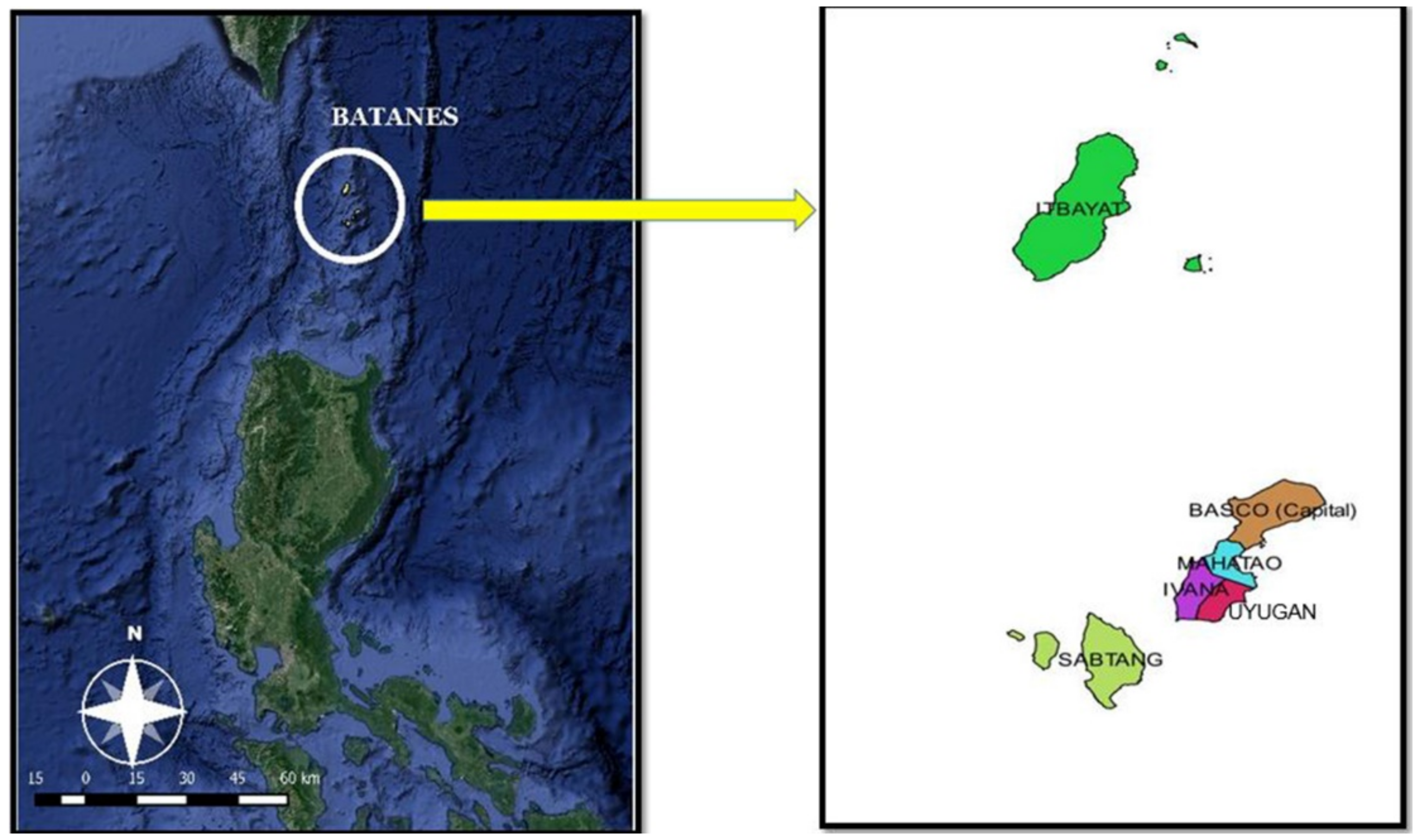
Practitioners’ Participatory Development of Indicators for Island Community Resilience to Disasters

by
Joan Pauline Talubo
1,2,*,
Roy Alvin Malenab
3,4,
Stephen Morse
5 and
Devendra Saroj
1,*
1
Department of Civil and Environmental Engineering, Faculty of Engineering and Physical Sciences, University of Surrey, Guildford GU2 7XH, UK
2
Department of Community and Environmental Resource Planning, College of Human Ecology, University of the Philippines Los Baños, Los Baños 4031, Philippines
3
Chemical Engineering Department, De La Salle University, Taft Ave., Manila 1004, Philippines
4
Chemical Engineering Department, College of Engineering and Technology, Pamantasan ng Lungsod ng Maynila, Intramuros, Manila 1002, Philippines
5
Center for Environment and Sustainability, Faculty of Engineering and Physical Sciences, University of Surrey, Guildford GU2 7XH, UK
*
Authors to whom correspondence should be addressed.
Sustainability 2022, 14(7), 4102; https://doi.org/10.3390/su14074102
Submission received: 13 January 2022 / Revised: 24 March 2022 / Accepted: 28 March 2022 / Published: 30 March 2022

Abstract

:
Despite the existence of a wide range of literature on indicators of disaster resilience in various geographical contexts that have been developed by different agencies and academia, not much has been done to include the insights of practitioners at the local level. This paper seeks to address the lack of practitioner insight and perspective by proposing a mixed methodology in developing composite indicators for the resilience of an island community to disasters. We used a combination of participatory approaches, such as semi-structured interviews with key informants, the web-based Delphi method, and expert interviews through a case study site in the Philippines—the Batanes island province. Principal Component Analysis (PCA) was utilized to analyse the data from web-Delphi, and the results from the content analysis of the interviews were used to support these findings. From a broad list of 144 indicators, the process identified 22 composite indicators for assessing the disaster resilience of an island community. We conclude that the development of new approaches for assessing disaster resilience of island communities is a positive step towards a better understanding and operationalization of the concept of resilience. The process followed in this paper is a significant milestone in developing new approaches to answer the question of what makes an island community resilient to disasters.

1. Introduction

Indicators are considered useful for testing hypotheses, model validation, creating information for policy and the development of knowledge base. However, indicator development is not straightforward, partly due to the intricacies involved when dealing with recovery for the long-term, the breadth and depth of the issues, the geographic extent of the area that has to be examined, and the dependence on data availability [1]. Thus, indicators alone should not be used as a stand-alone source of information for assessment and should be supplemented with other qualitative and quantitative data for the improvement of understanding of processes, outcomes, and paths to not just long-term recovery from disasters but developing resilience to it.
In the disaster risk management discourse, the concept of resilience has been considered ambiguous, not only in theory, but also in practice [2]. In this paper, we follow the definition of resilience of the UNISDR, [3]
“The capacity of a system, community or society potentially exposed to hazards to adapt, by resisting or changing in order to reach and maintain an acceptable level of functioning and structure. This is determined by the degree to which the social system is capable of organising itself to increase this capacity for learning from past disasters for better future protection and to improve risk reduction measures.”
At present, insights from practitioners or those who are involved in direct initiatives or work for building disaster resilience, are massively absent from the discourse [4]. The existing publications are almost exclusively dominated by researchers, scientists and experts in different sectors such as international organizations and agencies [4]. Further research is necessary to study how the concepts of disaster resilience are translated by practitioners at the local level for these to be applicable to the practice on ground [4]. Tariq et al. [5] reiterated that in the disaster paradigm, there is an increasing need to ensure the practical efficacy of indicators and these need to be appropriate for the unit of analysis, such as an island in the case of this paper.
We agree that the need, for communities, practitioners and local decision-makers to be able to conduct better assessments of their resilience to disasters from their own standpoints, still remains [5]. There is a requirement for a more inclusive and participatory resilience assessment process to be able to improve the understanding of the capacity of a community to anticipate and minimize the impact of hazards and re-establish basic functions to prior levels or even be able to transform or build back better [6]. According to Miller et al., despite the increasing number of research outputs in the development of resilience understanding, the documented cases of how the concept is operationalised at the practitioners level are very few [7]. This is validated by Keating and Hanger-Kopp [4] by claiming that in the grey literature, there were only four reports that tackled disaster resilience from a practitioner’s perspective.
This paper seeks to address the lack of practitioners’ insight and perspective by proposing a mixed methodology to develop composite indicators, for the resilience of an island community to disasters, through a combination of participatory approaches such as semi-structured interviews with key informants, applying the Delphi method, and expert interviews, applied to a case study site in the Philippines—the Batanes island province. The participatory methods that were utilized are Key Informant Interviews, web-Delphi method, and Expert’s interview. It seeks to develop indicators which are significant, practical, and manageable for local practitioners to implement in the ground. Furthermore, it ensures that these indicators have been validated statistically to address the science-policy gap in planning for disaster risk reduction and management, particularly in islands. However, this paper is limited to the development of indicators for disaster resilience of an island community.

2. A Brief Review of Development of Indicators on Disaster Resilience (Various Geographical Contexts)
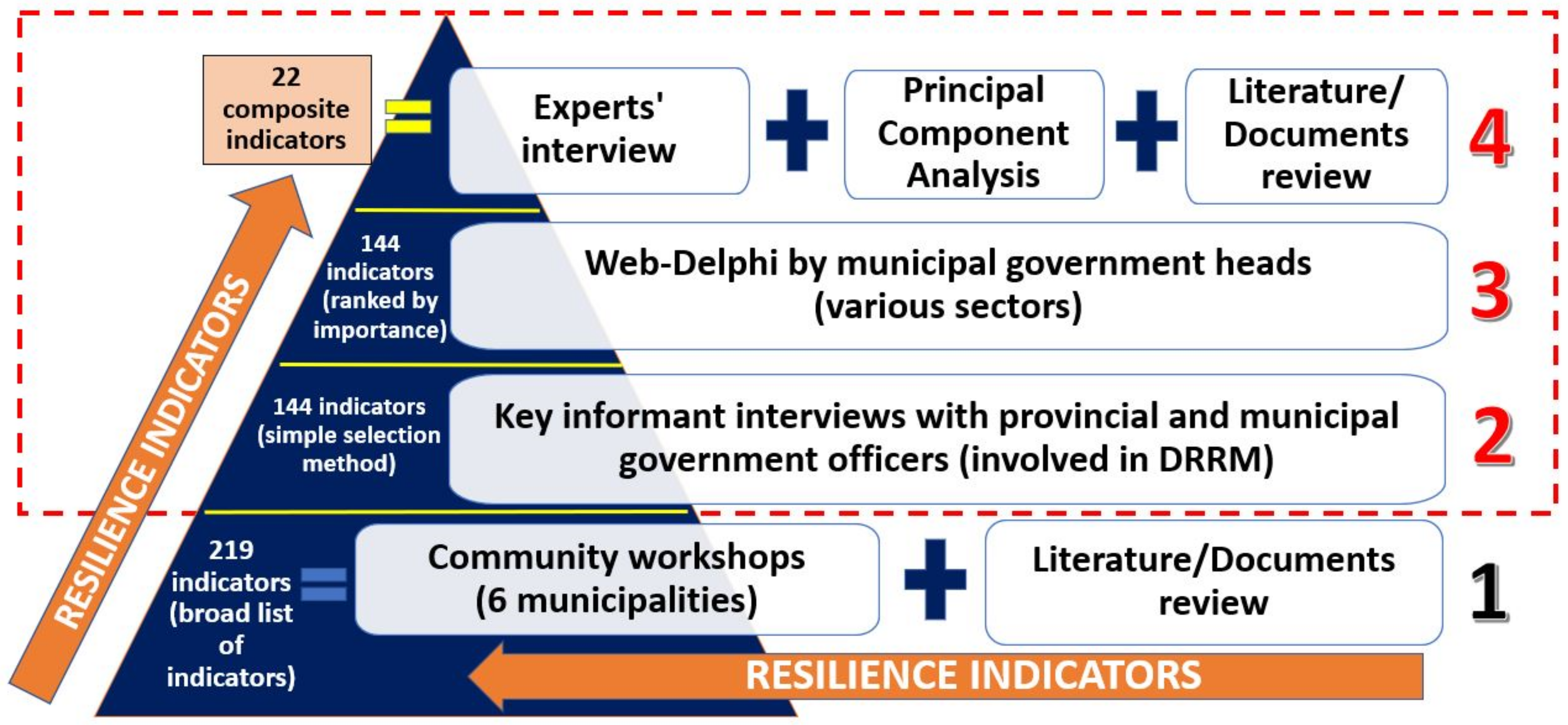
The indicator-based approach has been widely used for resilience studies. A brief review of the literature examined the existing frameworks and approaches for the index (where an index is comprised of several indicators) and indicator development of disaster resilience (Table A1 in Appendix A). Various agencies and researchers have constructed different indices from various sets of indicators to come up with a way to measure resilience to disasters in a variety of contexts. Assessments of relative resilience of geographic units that are indicator-based have been used extensively by aggregating the indicators into one composite index [8]. The place-based ‘composite indices’ of resilience could capture the snapshot of the most significant facets of resilience [9].
A composite indicator is created when several individual indicators are put together into a single index on the basis of an underlying conceptual model or framework [10]. Ideally, the purpose of the composite indicator is to measure multi-dimensional concepts that could not be expressed or represented by a single indicator, and so it is appropriate for the goal of this study. The advantage of a composite indicator is that it could synthesize and represent complex, multi-dimensional entities, and therefore could support decision-makers and significantly reduce the number of indicators without necessarily neglecting the underlying information [10]. The disadvantage of constructing composite indices is that they try to capture a lot of information within a single index and if poorly constructed, or if misinterpreted—it could send policy messages that could be misleading. It could also be misused if it lacks sound statistical or conceptual principles [10]. For example, there is the important issue of weighting to consider; should all component indicators be weighted the same?
Despite the wide, existing literature on indicators of disaster resilience in various geographical contexts, not much has been done to include the ‘grassroots’ in the discourse—both the community and the practitioners at the sub-national level. Most community resilience assessment tools were developed with the practitioners as the target audience, but with the primary developer being personnel based in academia or in international organizations [11]. A few studies have included stakeholder input during indicator development and used several participatory approaches in the process [12,13,14,15]. We build on the existing literature of community resilience assessment techniques, which has used participatory approaches, but also acknowledge that there is still a lack of involvement of practitioners in the development process. We reiterate that the body of work that uses participatory approaches remains relatively sparse and the insights of those who are involved in the direct implementation of policies and strategies of disaster risk management have not been fully considered in indicator development. Indeed, it can be argued that most of the indicators developed and used in resilience management have tended to come from existing literature and reports. Very little has been done in the geographical context of islands. In this paper, the original set of indicators used were derived via a soft-systems methodology that included community workshops and content/textual analysis. These indicators were further developed through a combination of participatory approaches at the practitioners’ level and statistical analysis.

3. Methodology

This paper proposes an approach on the development of indicators to identify the resilience to disasters of an island community by means of a case-study in the Philippines. The case study site is the island province of Batanes—composed of six municipalities namely Basco, Itabayat, Ivana, Mahatao, Sabtang and Uyugan. Batanes is in the northernmost part of the country (Figure 1).
The study was done in stages (Figure 2) using various methods to develop and filter the indicators to identify a final set of composite indicators. The stages were implemented in the following sequence:
  • A set of indicators was first identified from community workshops and a literature review [16]. This stage generated many important issues, and associated indicators (219 in total), related to resilience to disaster.
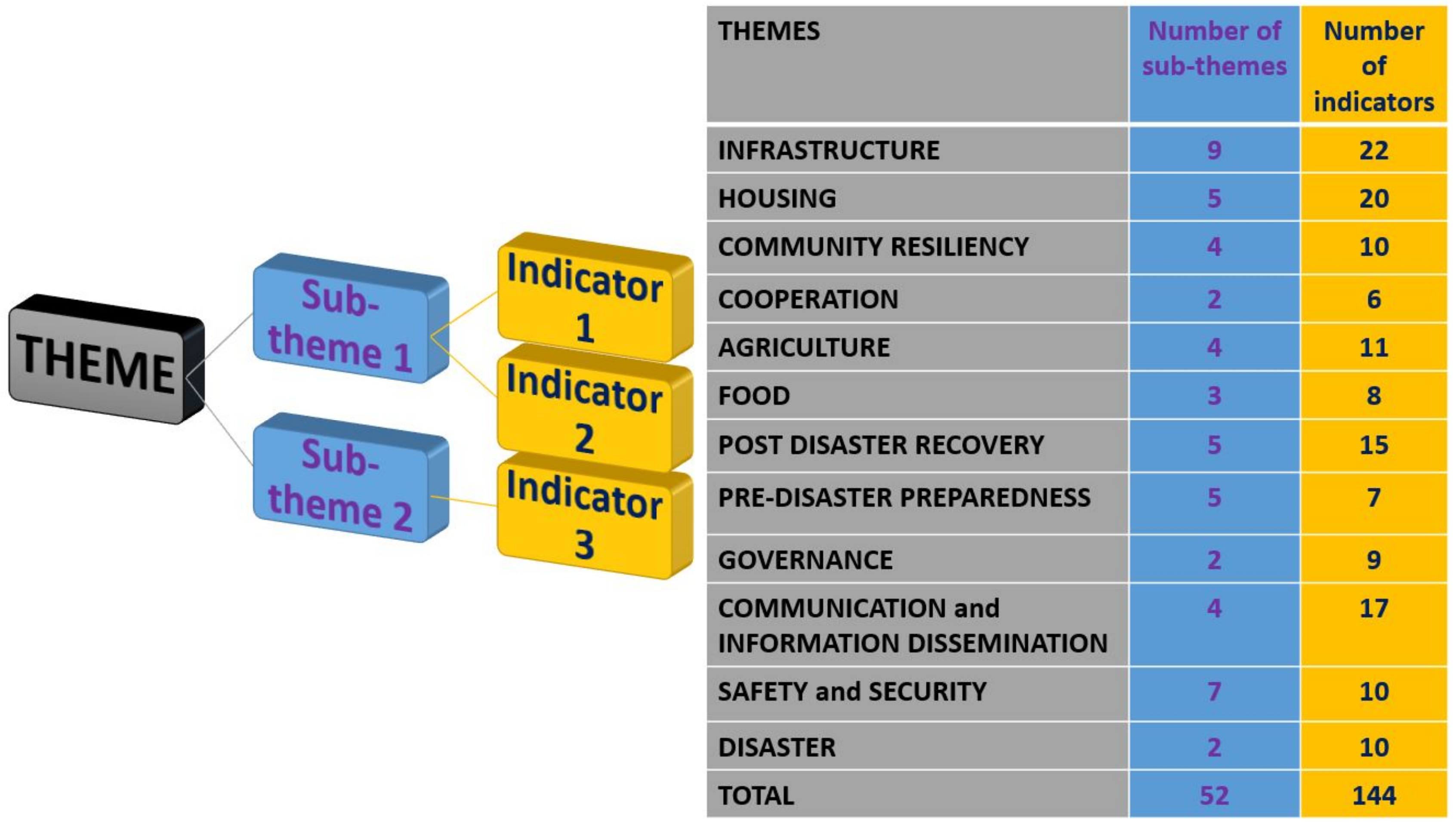
  • The indicators from (1) were filtered via key informant interviews with the provincial disaster officer and other relevant provincial officers plus the municipal disaster officers of the six municipalities through a simple selection method. The intention here was to explore the extent to which the community indicators matched those already in use, what indicators may be missing and to see what practical issues may be involved for those that are new. The output from this stage was a reduced set of indicators (144 in total) (Table S1) that was fed into stage 3.
  • A web-based application of the Delphi method was used to further prioritise the list of indicators (144) emerging out of (2). The use of the web-Delphi involved the municipal heads of various sectors of the six municipalities and respondents were asked to assess the degree of importance of the indicators.
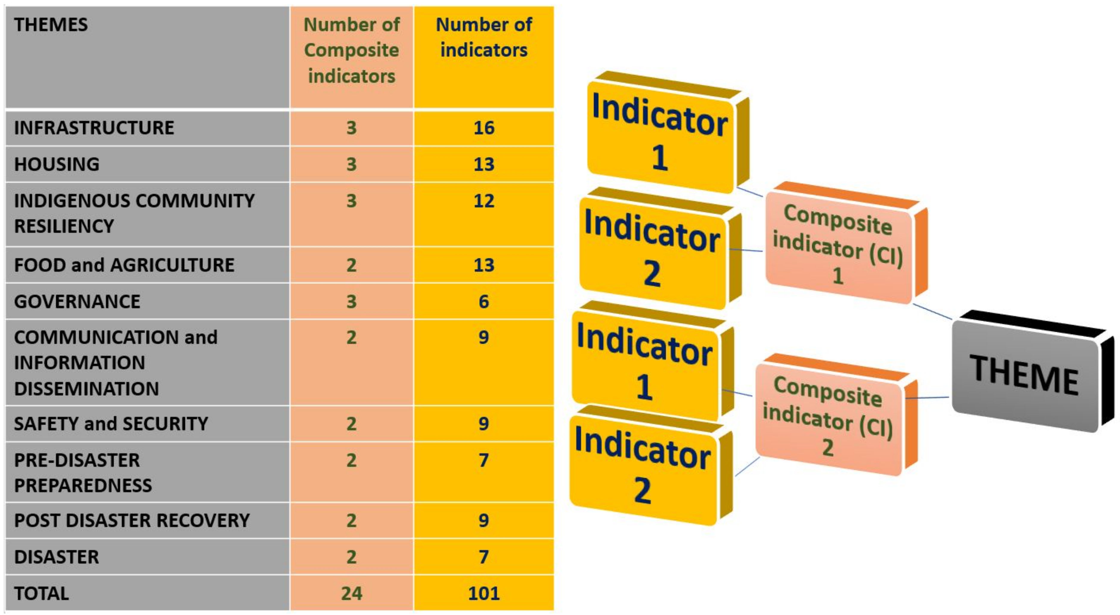
  • Expert’s interviews were conducted using the 144 indicators to elicit insights from other practitioners in the Philippines and support the results of the web-Delphi analysis. Alongside this, a Principal Component Analysis (PCA) was done to analyse the web-Delphi results. The findings from these stages and from the Key Informant Interviews, supported by literature and document review were all used to finalise the composite indicators.
The use of stages allowed for the filtering and enhancement of the indicators at different levels—from the community level to practitioners operating at the local level within the case study site, and lastly experts (practitioners at sub-national level). The key informant interviews were designed to elicit the perspective of officers in government departments and agencies directly involved in the disaster management process within Batanes. These interviews were entirely qualitative and provided a venue where they were able to explain why they chose specific indicators. The web-Delphi method was used to expand the input to include government officers in the other sectors indirectly affecting disaster risk management in their municipalities. In this stage, they were also asked for the degree of importance of the indicators by applying a five-point scale ranging from very-important to not important. In this stage, there were representatives from the six municipalities of the case study site.
The results of the PCA showed a degree of commonality between indicators and it was thus decided that some of them should be merged (as ‘composites’) and others deleted. Given the large number of indicators that were generated from the participatory workshops, constructing the composite indicator was necessary in order to remove any redundancies while still capturing the diversity of issues that communities regarded as important for resilience. Composite indices do have the disadvantage of compressing what can be a very diverse set of indicators into a single numerical value and much can depend on the assumptions taken regarding weightings. In this paper, the authors have addressed these disadvantages by employing an appropriate statistical process and by supporting the numerical findings with robust qualitative data from various stakeholders and actors which are involved in the decision-making and the community itself who are the ones directly affected by the impacts of a disaster.

3.1. Identification of Indicators

The initial/broad list of indicators used in this study was derived through a Soft Systems Methodology (SSM) approach that the researcher conducted in an earlier phase of the research. Details of the SSM workshops and the results obtained will not be provided here, but they were conducted with the members of the communities of the six municipalities of the province of Batanes. The qualitative results from these workshops were then analysed using content analysis and concept mapping to arrive at a broad listing of 219 indicators (grouped under themes and sub-themes) that the participants felt captured their vision of resilience to disasters.

3.2. Simple Selection Method of Indicators through Key Informant Interviews

The researchers conducted face-to-face interviews with ten key informants from the provincial and municipal government in Batanes, especially those who were involved in disaster risk management and other closely related sectors. They are the people who have the mandate and responsibility to make decisions for the community in the face of disaster. They are local to the area and have years of experience in working with direct implementation of disaster risk management. The median (IQR) age of the key informants was 51.0 (43.0 to 52.0) years. Most of them were males (80%) and were born in Batanes (70%) with median (IQR) length of residence in the province of 48.0 (41.0 to 51.0) years. All of them were college graduates and more than half had professional licenses (60%). They had been working in the local government with a median (IQR) length of service of 21.0 (10.0 to 30.0) years.
The key informants were presented with the list of 219 indicators and were asked to select which of the indicators they thought were important and should be included when determining the disaster resilience of their province/municipality. They were asked to select as many as they could among the indicators. More importantly, the respondents were asked to elaborate why they chose the indicators they did.
In this phase of the process, the indicators were filtered through a subjective process by which the checklist from the respondents were considered. The researcher included all the indicators which the respondents selected, even if only one key informant selected it. The 75 indicators that were not selected by any key informant were eliminated at this stage. The qualitative data gathered from the interviews in this phase were also used in the analysis towards the further filtering and development of the indicators. The remaining 144 indicators were then carried on to the next step (web-Delphi) in the research design.

3.3. Refinement of the Indicators through Web-Delphi

The Delphi method has been widely-used as an approach to indicator selection in disaster risk management and disaster resilience [12,13,14]. The Delphi process is a survey among participants involving multiple rounds of survey to arrive at a consensus [13]. A variant on the theme of Delphi is to use a web-based platform, often referred to generically as web-Delphi, where participants can go through the prioritisation process remotely. One such online tool is Welphi. Welphi as a research tool allows the researcher to conduct their own research design in a rigorous manner and it has technological tools that help the researcher to manage the implementation efficiently [17]. Welphi has been used for several previous studies on health, biomedical engineering, management, and industrial engineering (https://www.welphi.com/en/Applications.html, accessed on 20 October 2021) but to date has not been employed for establishing indicators of disaster resilience.
Sixty respondents were invited to participate in the process. The respondents were the head of the different sectors of the local government unit namely disaster risk reduction and management, agriculture, social development, and welfare, planning and development, health, engineering and civil registrar. Out of 60 invited respondents, 45 (75%) completed the online questionnaire, while 12% did not complete and 13% did not begin. The median (IQR) age of the 45 respondents who completed the web-Delphi survey was 46.0 (34.5 to 55.0) years and two-thirds were female. Most of them were born in Batanes (81.4%), and their median (IQR) residence stay in the province was 41.5 (27.5 to 52.5) years. They represented all the municipalities of the province in terms of work assignment as follows: Mahatao (22.2%), Itbayat (20.0%), Ivana (17.8%), Sabtang (15.6%), Uyugan (15.6%) and Basco (8.9%). All the respondents had a bachelor’s degree, 13.3% of them had a post graduate qualification, 55.6% held professional licenses and the median (IQR) length of local government service (in their respective municipalities) was 19.0 (5.0 to 23.0) years.
The web-Delphi process was implemented entirely online, and the respondents were asked to rank the 144 indicators (carried on from the earlier phase) according to the degree of importance in relation to disaster resilience. A Likert (5 point) scale was used to describe varying degrees of importance (5 = Very Important, 4 = Important, 3 = Moderately Important, 2 = Slightly Important and 1 = Not Important). Only one round of the web-Delphi scaling of indicators was implemented, and this was followed by discussion with a panel of experts to help with interpretation of the findings.

3.4. Expert Interviews

Following the web-Delphi process, we conducted interviews among eight experts on disaster resilience in the Philippines (Table 1) to obtain insights from other practitioners working on disaster risk management in the country regarding the list of indicators. While the key informants (stage 2) and web-Delphi respondents (stage 3) were local practitioners in the area who were experts in their own right, this final stage of the indicator development involved experts who have several years of experience in different parts of the country at the sub-national level and included local practitioners in other coastal and island municipalities. The experts consulted were from four different sectors involved in disaster risk management in the country (one or two representatives from each sector). The eight experts came from the following sectors: academia, national/regional government, non-profit organisation/national or international research organisation, other local government employees from island and coastal municipalities. This was conducted to have another layer of perspective to the analysis of the indicators and to obtain insights of not just the local authorities in the case study site, but the country experts who have worked in the disaster management arena for years and have knowledge and practice on indicators in this field. The motivation for this stage of the process was to be able to include a perspective and tackle the issues that the local participants might have missed. This was a way to further enhance the indicators and to support the quantitative results of the statistical analysis with qualitative data from the interviews.
The experts were identified through the internet and networks in disaster risk management work and then invited through email. An initial talk was done online through Zoom prior to setting the actual interview. In the initial talk, they were asked if they agreed to participate in the interview. An introduction and background to the research were also provided and they were oriented on the details of the interview.
After the initial talk, they were emailed a brief overview explaining the research and an advanced copy of the guide questions for the interview and the list of the themes, sub-themes, and indicators (144 at this stage). A 90-min semi-structured interview and discussion was then undertaken via Zoom about the indicators, with the guide questions as follows:
  • What do you think of the indicators associated with the sub-themes and themes?
  • Do you think they are appropriate for disaster resilience of small islands?
  • How are they similar or different from existing ones for disaster resilience?
  • How are they similar or different from urban indicators?
  • From these indicators (144), could you please identify what you think are the core indicators of disaster resilience for small islands? Please explain your answer.
  • Are there indicators which you think are similar/related to those identified from the workshops but expressed in a different way in Philippine policies/practice/implementation?
  • Are data available for these core indicators? Please elaborate on the sources/availability of the data that are required.
  • What do you think is the most appropriate number of indicators required to determine the disaster resilience of small islands? Please explain your answer.
  • Could you please refer me to significant literature/reports/documents which could aid in the analysis of this phase of the research

3.5. Statistical Analysis: Principal Component Analysis and Reliability Analysis

Due to the large number of identified resilience indicators, Principal Component Analysis (PCA) was employed to reduce the number of indicators and to reveal a smaller number of underlying components which best described variation in the responses. This technique produces a low-dimensional set of robust and consistent composite indicators that can be used to describe resilience to disasters of an island community [18,19,20].
This study followed the standard procedure in conducting PCA. First, the application condition of factor analysis was checked using the correlation coefficient matrix, the Kaiser–Meyer–Olkin (KMO) measure of sample adequacy, and Bartlett’s test of sphericity. The KMO test measured the sampling adequacy and evaluated the correlations of the data [21]. As a general rule, the KMO values should be at least 0.6 for the sampling to be adequate [22]. In addition, to test if the correlation matrix was an identity matrix (null hypothesis), Bartlett’s test for sphericity was performed. Rejection of the null hypothesis indicates that a factor analysis may be useful for structure detection [23].
The procedure to determine the number of components to be retained in PCA is crucial. A Kaiser criterion (eigenvalues > 1) is usually employed. For this study, parallel analysis (PA) was preferred because it is more accurate, efficient, and robust for determining the number of principal components to retain for further analysis and interpretation when decomposing a correlation matrix [24,25]. In this procedure, eigenvalues from a data set prior to rotation were compared with those from a matrix of random values of the same dimensionality. If the PCA eigenvalues from the data were greater than PA eigenvalues from the corresponding random data, the component was retained otherwise considered fictitious [24].
In factor analysis, the varimax method, an orthogonal rotation extraction procedure, was used to ensure maximum independence of the resulting factors. The varimax rotation minimizes the number of variables that load high on a single factor, thereby increasing the percentage variation between each factor [26,27]. An indicator was retained and assumed to be relevant for the component if its factor loading was 0.4 or above [28,29,30]. For cross-loading, when an indicator was found to have significant loadings to more than one component, the indicator was assigned to the component with higher or highest loading. If the loading difference was 0.2 or below, the indicator was deleted [31].
Lastly, the internal consistency was assessed by computing Cronbach’s alpha, where the recommended value ranges from 0.7 to 0.95 [32,33]. In this paper, we used Cronbach’s alpha > 0.7 which has been used in constructing composite indicators and for resilience indicators on disasters [10,34,35]. If the Cronbach’s alpha was not acceptable, an item was deleted to improve the internal consistency.

3.6. Ethical Considerations of the Study

This research has undergone an ethics review in the university and has received favourable ethical consideration prior to the conduct of the study. The principal investigator went through the process in Batanes for the conduct of the research in the area (e.g., courtesy calls and submission of paperwork). The principal investigator had to secure a free and prior informed consent from the community in the case study site as approved by the mandated institution on indigenous peoples. A permit from the environment office was also secured before the conduct of the research. All the respondents were given information sheets about the project and gave their informed consent before any data collection was conducted.

4. Results and Discussion

4.1. Building and Refinement of Indicators of Resilience to Disasters of an Island Community

The broad list of indicators that came from the community workshops and key informant interviews were under 12 general themes namely: Infrastructure, Housing/Shelter, Safety and Security, Governance, Pre-disaster Preparedness, Post-disaster Recovery, Communication and Information Dissemination, Agriculture, Food, Community Resilience, Cooperation, and Disaster. The key informants confirmed that the themes and sub-themes are indeed representative of the resilience to disaster of their province/municipality. However, when invited to choose among the 219 indicators from the community workshops, these were reduced to 144 indicators after the key informant interviews (Figure 3). The perspective of the key informants was not much different from that of the community as most of the local government employees were community members themselves.
The themes were all important for them when considering disaster resilience of their community. They had various insights about the specific indicators too and the number of indicators which they thought would represent their resilience to disasters. This was also reflected in their selection. Some selected a few indicators, while some checked a higher number of indicators to represent their municipality.
The experts also found the original set of indicators (144) relevant, appropriate, comprehensive, detailed and context-specific. These indicators addressed the whole range and spectrum of disaster risk management and goes beyond that. And that is what disaster resilience is all about—it addresses both prior to a disaster happening and beyond short-term recovery and rehabilitation. They found the indicators to be a good representation of disaster resilience of an island. But when asked to choose indicators, they tended to prioritise those they thought to be more practical and manageable with regards to implementation from the policy perspective. One of the most crucial criteria for them was to ensure that the indicators did not add another layer of work to what is already required of the local government employees, given that resources were always limited, and most offices lack sufficient employees, and the existing employees also lack the technical capacity to perform the required tasks. This set of very specific and detailed indicators could work for smaller units at the community or village or barangay level (the smallest administrative unit in the Philippines), or municipal level—but would be more difficult for the provincial or regional level. They recommended to involve the barangay level in data collection as this will be easier as they have a smaller unit and area of interest.
The interviews also revealed that implementation of the disaster risk management plans at the local level is usually the main issue in the Philippines. The implementation of the plans is often tainted with political issues and when the administration changes, the implementation of the plans also changes—especially at the local level. This has implications on the indicators used for making the plans as well as when these plans are implemented.

4.2. Towards Developing Composite Indicators for the Disaster Resilience of an Island Community

The findings of the Principal Component Analysis revealed that some indicators needed to be deleted and most indicators overlapped with one another. This was due to the commonalities in the said indicators. The hierarchy was changed, from the indicators that were merged to comprise the composite indicators that emerged under the different themes (Figure 4).
The following is a discussion of the composite indicators (organised per theme) from the results of the PCA, perspective of the key informants, insights of experts and review of existing literature. The potential units for measuring the indicators comprising the composite indicator are varied, some are straight forward, and the units could be easily defined, some have a binary value (Y/N), while others need to be qualified with more specific and in-depth metrics.
Evacuation centres serve as a refuge for the community when a disaster strikes the area (Table 2). For the case study site, they rely more on the adopt-a-neighbour system wherein they go to the nearest relative’s or neighbour’s house. It is also common in the Philippines to use other buildings as evacuation centres in case of disaster like schools, barangay halls (village hall) or basketball courts. Some municipalities have no actual structures for evacuation centres. For Batanes, actual evacuation centres (with built structure designated as such) in the municipalities have only recently been built due to lack of funding and space (land area) to build one. At present, not all the six municipalities have one. There is one for the whole province located in the capital. Other evacuation structures are underway as of this writing, while some have no space to build it on.
Structural mitigation measures including sea walls, retaining walls, flood control structures are critical for minimising the impacts of natural hazards that an island could face. Structural measures are commonly used by all small island developing states (SIDS). The most common infrastructure for protection are seawalls—these are found in most island communities (e.g., RMI, Kiribati, and Mauritius) [36]. Sea walls are considered one of the oldest mitigation structures in small island and coastal communities. Whilst Kiribati use mass concrete and sandbags as seawalls, in RMA concrete seawalls are considered and proven to be stronger and more cost-effective than sandbags [36]. In the Philippines, the concrete walls that are built to minimize the impact of storm surges in coastal areas (mostly island communities) are not just structures that protect lives and livelihoods but also viewed as representations of the achievements of the villagers in cooperation with local authorities, if built in a participatory manner [37].
The critical lifeline infrastructure emerged from the group of indicators like shelter port, roads, power lines and water infrastructure. It is defined as the infrastructures that provide services to the community. Lifeline systems are the facilities/structures that
“form a network of structures that perform a vital function that is of critical importance to the normal functioning of the community (i.e., power/electrical network/grid, telecoms, water mains/supply, road/transportation networks, etc.).”
[5]
This is important for the resilience of the community to disasters as this ensures the welfare and well-being of the constituents—that they can get the basic services from the structures that are supposed to deliver them. This is based on the premise that a city, or an island, for this case, is resilient to disasters when the physical structures are well-functioning and able to provide the vital services to the members of the communities. By ensuring that the critical lifeline structures are well-maintained and well-equipped, the probability of having a shock is minimised, this may also enhance the community’s capacity to respond to impending disasters [38]. For island communities like Batanes, this is comprised of shelter port, power lines, water pumps and pipelines, road networks, and sanitation facilities (including a sewage treatment plant).
Housing (Table 3), though being a part of the Infrastructure theme, was considered a separate theme because the community in the islands consider it a symbol of their resilience. Being safe inside their houses in the event of a hazard makes them resilient in their perspective. In an island setting, the communities place a high value on the house which keeps them safe from various types of hazards over other infrastructure in the built environment.
Housing is at the core of resilience for the island community of Batanes. The housing type is important as the community considers their traditional/vernacular houses as one of the main contributors to resilience. They practice traditional ways of securing the safety of their houses prior to a disaster and they also help each other through the traditional way of ‘bayanihan’ or cooperation (which will be discussed in the following theme: indigenous community resiliency). The traditional house has kept them safe from typhoons for many years given its unique architecture which was designed to make them resilient to typhoons. House safety from impending hazards also came out as a composite indicator, as the island has a traditional way of securing their houses from typhoons in particular, for they are most prone to typhoons in their area. They have devised a traditional way of securing their houses from the impacts of strong typhoons. The practice of making their houses safe and secure from a disaster needs labour and materials and this entails costs. The cost of the labour and materials for these practices emerged as another composite indicator. It is usually free when the tradition of ‘bayanihan’ is done by the community to help each other secure their houses. Even then, they still must buy the materials (e.g., ropes and large nails for grounding—and big blocks of wood for securing the windows) for securing the house in a traditional manner.
We introduce in this paper a theme called ‘Indigenous Community Resiliency’ (Table 4). It is an emerging theme from the two original themes, which are ‘Community Resilience’ and ‘Cooperation’. We use the term indigenous to emphasize that this theme is composed of inherent characteristics and capacities of the community, which reflects the inherent indigenous knowledge, systems and practices of the community—including culture, heritage and belief systems. Scholars have long recognised local-indigenous knowledge as an important contributor in both the understanding and management of environmental change [39]. In disaster risk management study and practice, substantial evidence has emerged over past decades that local-indigenous knowledge plays an important role in the enhancement of the process of disaster preparedness, response and recovery [39]. Several studies, particularly in islands, have confirmed the use of local indigenous knowledge for the survival and recovery from disasters [39,40,41,42,43,44].
This study validates the importance of IKSP in the resilience of an island community to disasters. This was evident from the perspective of the community, local government employees and the experts. The experts emphasized that IKSP plays a huge role in the adaptation of the community—and this is what we might be missing in the disaster risk and recovery planning process in the Philippines. At present, the climate and disaster risk assessment done at the municipal level does not include IKSP as an indicator and as emphasized by this expert who works in this area—the present review and assessment of the manual reveals that IKSP should be included. It is very important to integrate IKSP in the risk assessment because this is innate and inherent to the capacity to adapt of the community instead of introducing capacities that is entirely new or entirely different from what the people in the island are used to. Most especially in a small island setting, it is better to recognise what is innate to them and build on that. For Batanes, their IKSP cuts across other themes such as housing, communication and information, food, and agriculture.
One salient finding of the study is that each island community has characteristics inherent to them that could be built upon and help them build and strengthen their community resilience to disasters. Policies and processes often neglect this fact and suggest a one-size-fits-all process for disaster risk and recovery planning in municipalities. At present, the assessments being done are also just risk assessments and do not include resilience as a concept. The local government officers also support the inclusion of the IKSP in school curriculums—to be able to educate the youth at an early age and embed in them an ability to transfer the indigenous knowledge to the younger generation.
Whilst partnerships and collaborations from outside sources are important, resilience should begin and develop within the community itself, especially in island communities where they are isolated, and it is more difficult to access or get assistance from mainland communities given the distance and limitations to be able to reach the island. What is inherent and innate to the community should be developed—without expecting and relying too much on external help. Given that islands also get smaller funding than other urban places—being self-reliant would help build and strengthen their resilience. Self-reliance has been considered significant for the ability of a community to be resilient—defined as the ability to endure without being excessively dependent on external assistance [45]. It could also be interpreted as self-organization, wherein communities and social groups and systems are able to organize themselves on their own [46]. The communities in Batanes emphasized their ability to be self-reliant and to be able to organize and help themselves before, during and after a disaster, without needing assistance from even their own local government or external groups.
Part of what makes the community in the case study site self-reliant is the practice of Bayanihan. Bayanihan is derived from the root word bayan which means town or community. It is a Filipino custom of a community working together to achieve a common goal. We shall refer to it in this study as Cooperation. Cooperation or bayanihan is still very much practiced in Batanes—and in some other places in the country. It is more common in rural areas than in urban places. The rural areas have a strong sense of community, and this is reflected in their capacities and the ways they adapt to disasters. For example, in Batanes, instead of using evacuation centres, they would prefer to go to their relative’s or neighbour’s house. This could be a counterproductive practice though, depending on the location of the houses, whether they will still be at risk when they move from one house to another during the occurrence of a disaster. They also help each other when securing the house before a disaster or repairing houses and doing clearing operations on roads. We shall call this composite indicator ‘Community Cooperation’ to emphasize that it represents social cohesion among the members of the community and the networks which help them help each other.
There have been a few studies which include religion or belief system as an indicator of resilience to disasters [13,47,48]. Aslam Saja et al. [47] included it as an indicator of social resilience under the social beliefs/culture/faith sub-dimension stating that social beliefs can be crucial in determining social resilience to disasters. They argued that social beliefs must be used as a positive capital in communities that have a strong orientation of their own local faith/belief system. Frazier et al. [48] also identified it as an indicator of community resilience under social capital in community capital. In the grey literature of disaster resilience as identified by international agencies, religion or faith/belief system has not been explicitly identified as an indicator of disaster resilience. Alshehri et al. [13] referred to it as personal faith and attitude under the social dimension.
In the eyes of the community, it is a determinant of their resilience. However, it could also be counterproductive with a fatalistic, leave-it-to-God (or the supreme human being that they believe in) attitude which results to inaction in the event of a disaster. On the other hand, given the right motivations and strategies, this could aid in building the resilience of the people through accessing their belief system and using it as a platform for preparing for disasters or recovering from it. It came out as a separate group in the PCA and is very evident in the discussions of the community in the workshops.
The themes Food and Agriculture have been combined to form one theme—‘Food and Agriculture’ (Table 5). The PCA resulted to only one group of indicators for ‘Food’ and another group of indicators for ‘Agriculture’—and given that the two themes are very much interrelated and interconnected—especially in rural communities—thus the decision to merge them into one theme. This decision is reflected from the locals’ perspectives and was confirmed by the interviewed experts.
Food supply and having access to food sources is crucial for island communities—at different stages of the disaster cycle. Crops, fish, and livestock are major sources of food for these island communities given that they are isolated from the mainland and more evident especially for rural island communities. Food supply is determined by the quantity of crop produce generated by the farmers or the fishing catch. The commercial goods are imported from the mainland thus most of the food supply come from the farming and fishing community. In Batanes, they also have an efficient traditional food storage and preservation system which is designed around the cropping and fishing calendar which helps them to become food self-sufficient in the face of disasters [49]. Most households have small parcels of land (about 500–1000 m2) for farming and grazing, which is mainly for the family’s own food consumption. Access becomes a problem only for the commercial goods which are imported from the mainland. After a disaster in Batanes, they don’t really need the relief goods that are distributed as assistance, as they have stored agricultural products.
Governance plays an important role in determining the disaster resilience of an island community. We validate the previous findings that Governance is a vital aspect of building resilience to disasters [50,51,52,53,54,55]. Policies and its implementation are crucial in disaster risk management. In the case study site, despite the community referring to themselves as self-reliant, the planning and decision-making mandate still goes to the government institutions from national to provincial to municipal and village level. The community is directly and most impacted by the local government—from provincial down to municipal and barangay leaders. We rename the original theme ‘Governance’ to ‘Disaster Governance’ to further emphasize the role of governance in disaster resilience and narrow down governance (which is a very broad term) to its institutional definition within disaster risk reduction and management (Table 6).
The role of governance is commonly downplayed in the disaster arena, being overshadowed by ‘disaster risk reduction’ or ‘disaster risk management’ [52,56,57]. This is due to the framing of disasters as an external event that demands reduction or management of risk through reduction and engineering approaches [57]. The term disaster governance is relatively new in disaster literature—wherein you find more of the use of disaster management and disaster risk reduction as syntax when talking about governance in disaster [50,52].
Existing literature defines disaster governance as
“an umbrella term for distinct yet interrelated organizational and institutional processes for reducing disaster risks and managing their impacts and also refers to the diverse and vast networks of actors—representing governments, multilateral organizations, NGOs, faith groups, local communities, academia/scientists, and the private sector—that connect and interact to co-govern disaster risk reduction and management at different levels.”
[58]
We agree with this definition of disaster governance but also introduce our own spin in this paper: Disaster Governance is both a system and a process that involves participation and engagement from the various stakeholders involved in disaster risk management to be able to facilitate a collaborative and action-oriented decision making. Furthermore, we validate that there is no single authority that could command compliance among all the actors and stakeholders who participate in the systems of governance [52].
This definition reflects the composite indicators which resulted under this theme. The first one reflects how the community is informed and educated about disaster risk management. One of the experts emphasized the role of educating the family or household as a unit in disaster risk management—that the mindset is embedded into the day to day lives of the community and not just when a disaster strikes or hits the area.
The second composite indicator is Funds allocated to disaster risk management, not just the amount per se, but how it is distributed and allocated within the community. According to Section 21 of the Republic Act PDRRM 10121, a municipality gets a local calamity fund called the Local Disaster Risk Reduction and Management Fund (LDRRMF) which should not be less than five percent (5%) of the estimated revenue of the municipality from regular sources. This shall be used to support activities on disaster risk management such as (but not limited to) acquiring and purchasing of supplies, equipment and medicine, programs and trainings on pre-disaster preparedness, post-disaster activities and for climate insurance payment (RA10121). Thirty percent of the LDRRMF shall serve as Quick Response Fund (QRF) or funds that are on stand-by for recovery and relief programs for the normalization of lives of the communities affected (RA10121). One of the experts argued that for the case of the Philippines, the definition of hazards for the allocation of funds is at times not appropriate for islands. The way the budget is allocated according to the policies is how the hazard is defined, but the definitions are loose and do not account for hazards that are specific for islands.
Communication and information dissemination is crucial throughout the whole disaster cycle (Table 7). The access to various modes of communication and information about the weather monitoring and impending disasters is necessary for the whole community. The communication infrastructure is important to be able to have a reliable early warning system and other modes of communication and information dissemination—mobile network site towers, two-way radio systems, television, weather stations, and advisory bulletins. The flow of communication is also important—from the local authorities to the communities. For the island of Batanes, they have a system in place for the transfer of information from the local government authorities to the barangay leaders (village level) to the communities. Two-way radios have been distributed to local government officials (most especially those involved in disaster risk management), from provincial to municipal to village levels. This enables them to be able to communicate in real-time and disseminate crucial information. Installation of repeaters for better signal coverage in the two island municipalities has also been done to enhance communication.
An Early Warning System (EWS):
“represents the set of capacities needed to generate and disseminate timely and meaningful warning information that enables at-risk individuals, communities and organizations to prepare and act appropriately and in sufficient time to reduce harm or loss”.
([59], p. 5)
We name it as community-based early warning systems in this paper—emphasizing the role and significance of the community in early warning at the onset of a disaster in an island setting. As stated in the definition, the access of the community, the assurance that the warning reaches everyone in a timely manner and that the proper authorities can make actions prior to the disaster, deems the EWS efficient and effective. In the case of Batanes, they have traditional early warning systems that have been used in terms of the community’s needs and capacities.
Livelihood security is crucial for the life and well-being of an island community (Table 8). Their source of livelihood is necessary for their survival and subsistence and the disruption caused by disaster events. The most common livelihood in island and coastal communities are farming and fishing, apart from working for the local government or as school teachers or policemen. Depending on the type of island and the situation within it, some may also be involved in tourism as business owners of lodge or workers such as tour guide. Small businesses are also evident in islands—small retail stores, local restaurants, and small market stalls. In Batanes, most of the community members are farmers and fishermen. Small businesses abound more in the capital (Basco) where much of the commerce and trade is occurring.
The second group of composite indicators refer to public safety at any phase of the disaster cycle as part of the safety and security theme. These includes disaster prevention and emergency management and making sure there are no casualties nor injuries brought about by a disaster. The two main factors to be considered in the communication flow are the citizens and authorities. Emergency management is deemed effective when the authorities are able to communicate in proper timing with the citizens who are at risk to the certain hazard and give them the necessary information about the hazard as well as the actions that they have to undertake to protect themselves [59].
The composite indicators under Pre-disaster preparedness are the ones that are considered important before a disaster strikes the area (Table 9). Basic needs include food, water, and shelter while basic services include water, electricity, and sanitation. These two are necessary for preparing and ensuring that the community have their fundamental needs before a disaster strikes and they have enough to be able to maintain their well-being during and after the disaster. According to Petit et al. [60] Preparedness refers to those activities that are done by the community in anticipation of the threats/hazards, and the potential consequences which it is subjected to. A study conducted by the Harvard Humanitarian Initiative on perceptions of disaster resilience and preparedness in the Philippines showed that most of the Filipinos prepare various household items and other consumables as a response to a disaster early warning [61]. Specifically, the percentage of Filipinos would prepare the following: 66% (food and drinking water), 42% (clothing), 22% (medications), 20% (cash), 13% (important documents) [61]. The study also pointed out that there are important variations depending on the region. Higher percentages of Filipinos living in the National Capital Region (NCR) were found out to prepare important documents (31%) and cash (26%) compared to the Negros Island Region, where only 2% would secure crucial documents and only 8% would have cash ready [61]. This validates the findings in this study that island dwellers would secure food and water more than anything else to prepare for an impending disaster. As mentioned by one of the experts working in another island province, cash is not that important, so long as the communities have food to eat. It is true for the case study site (Batanes) having indigenous food storage systems which make them food secure and sufficient in the face of natural hazards.
Securing basic needs, which include food, water and shelter, while also having access to basic services such as water, sanitation and electricity prior to a disaster is necessary for the survival and well-being of the community subject to a hazard. A city or area that functions well is able to provide the fundamental necessary services for the well-being of the communities—this helps enhance the capacity of the community to respond to a hazard if they are equipped and the basic services are well maintained [38].
The ability to be able to recover after a disaster is at the core of resilience to disasters (Table 10). Water, sanitation and health (WASH) and Energy and Transportation emerged as the two group of composite indicators under Post-disaster recovery. After a hazard has disrupted basic services in a certain place, access to safe water, energy and electricity, road and transportation and sanitation facilities becomes the primary challenges for the community. A resilient community can continue with the basic day to day living and maintain the constituents’ well-being with the necessary services that they need after a disaster strikes the area.
In Batanes, clearing operations are done immediately by the community without waiting for the post-disaster recovery operations by the local government. Power outages are a problem given the conditions of the island and some private businesses have a generator to compensate for this. The island has also shifted to underground electrical lines as it is safer from the strong winds that typhoons bring. There have been recent projects as well on considering alternative renewable energy sources for the island. One of the experts noted that what island dwellers needed most are electricity and mobile signal to be able to get information before, during and after a disaster. This is validated by the study by Bollettino et al. [61] that a mobile phone was useful to be able to receive messages of early warning or locate family and friends, while diesel run generators are needed to still have power when the grids fail during typhoons. Despite power failure being frequent in the whole country, only 2 percent of Filipinos own a generator [61]. Depending on the size of an island, transportation could be affected by natural hazards in various ways. In Batan, the main island in Batanes, there is one main road network, which encircles the island, while the rest are narrow street roads. They claim to be hardly affected as the roads do not get damaged a lot. But one blockage in this main road network would make travelling from one municipality to another delayed, or impossible for a certain period. The case for Itbayat and Sabtang is different as boats are necessary to be able to travel to these island municipalities. Two weeks of not being able to travel by boat due to typhoon and strong winds and waves will cause a shortage of supply of commodities for these islands. Some residents could also get stranded in the mainland or vice versa because of this.
Water, sanitation, and health (WaSH) is often overlooked as an indicator but of significant importance for the resilience to disasters especially in an island community. Safe and potable water is a fundamental need for communities and cities, not only in islands. It becomes more crucial post-disaster given the damages that a hazard such as typhoon or earthquake could bring to an area. The impacts of these natural hazards make it harder to maintain the services that provide water, sanitation, and health in communities. Infrastructure for water and sanitation has been proven to be critical for good health. Having access to water in-house and services for sanitation significantly reduces the risk of exposure to germs, viruses or bacteria [62]. In India for example, it was found that the possibility of diarrhea in children was 21 percent lower for households that have access to piped water [63]. Benefits for public health brought about by improvement in sanitation facilities also grow in the long-run [62]. The humanitarian and aid agencies are focused on prioritising assets such as shelter and livelihood over WaSH systems [64]. Results from a case study from Eastern India suggested the need for a better programming of these systems for building community resilience through integrated approaches considering the pre-disaster practices, recovery and development plans with adequate participation from the stakeholders [64].
Disaster is defined as
“a serious disruption of the functioning of a community or a society involving widespread human, material, economic or environmental losses and impacts, which exceeds the ability of the affected community or society to cope using its own resources.”
[3]
While Hazard is defined as
“the potential occurrence of a natural or human-induced physical event or trend that may cause loss of life, injury, or other health impacts, as well as damage and loss to property, infrastructure, livelihoods, service provision, ecosystems and environmental resources.”
[3,65]
We have referred to hazard in this paper as natural hazards. We would also like to reiterate that we agree with other scientists that there is no such thing as a natural disaster, thus we use disaster as disaster, while we refer to hazards as natural hazards. These two terms have been used interchangeably by the community, the key informants, and the Delphi participants (local people of Batanes). The experts have pointed out the difference in definition and that this should be considered and implicated when talking about disaster resilience.
The two composite indicators under this theme (Table 11) are Impacts and Exposure, which are influenced by several factors as indicated by the indicators under each group. Different degrees of exposure would have different impacts in different communities. For an island setting, it is important to be able to identify the specific hazards the area is vulnerable to—to be able to also find the best strategies to make the community more resilient. This is also crucial for the crafting of disaster risk reduction and management plans.

4.3. Integration

The findings of the reliability analysis (Cronbach’s alpha > 0.7) revealed that all the 24 composite indicators are consistent and no further indicators comprising the composite indicators were deleted at this stage (Table 12). The results of the PCA were retained and no further deletion was done at this stage of testing for reliability analysis. Composite indicators 3, 13 and 20 were slightly lower than 0.7, but if had been rounded off to the nearest decimal point, would still be 0.7, so we decided to retain all three.
From the original number of 12 themes, only ten were left after combining some themes into one. Out of the ten—seven are thematic/sectoral, while three are temporal. The final thematic/sectoral themes are Infrastructure, Housing, Indigenous Community Resiliency, Food and Agriculture, Governance, Communication and Information Dissemination, Safety and Security (Table 13). The three temporal themes are the stages/phases of a disaster cycle: Pre-disaster preparedness, Post-disaster recovery, and Disaster/Hazard. Upon taking a closer look at the composite indicators under the temporal themes, some could be considered under the sectoral themes. Basic needs (food, water, shelter) corresponding to CI 19 and Basic services (water, electricity, and sanitation) corresponding to CI 20 under the Pre-disaster preparedness theme is covered under Food and Agri, WaSH, Energy and transportation and Housing respectively. While WaSH and Energy and Transportation—under Post-disaster recovery should also be moved to Safety and Security and Infrastructure respectively, as it could be covered under these sectoral themes. This is from the premise that the composite indicators each could be considered or categorized at the different stages of the disaster cycle (pre and post disaster). The theme ‘Disaster/Hazard’ will be renamed ‘Hazard’ as a stand-alone theme that is not temporal nor sectoral.
One salient finding of the study was that for resilience to disasters, especially for the case of island communities, there is no “one-size-fits-all” approach to its assessment and strengthening. We agree with others [66,67,68] and emphasize that there is no one way to measure or assess resilience and there should not be. This set of indicators that we propose for an island setting results from a process that is both scientific and participatory.

4.4. Limitations of the Study

This paper will not discuss the temporal characteristics of the indicators of island disaster resilience. The pre and ante nature of resilience to disasters will not be discussed. There are different schools of thought on whether resilience should be measured before or after a disaster strikes, or both. As this paper will not include the measurement of these indicators, the temporal characteristics of these indicators shall not be discussed. These indicators shall be considered static for the purpose of this paper. Consequently, the metrics/units of measurement for the indicators will not be included in the discussion.

5. Conclusions

Indicators are vital for the measurement and operationalization of the concept of resilience. The development of mixed and diverse frameworks and indicators for measuring resilience should be considered as a positive step in moving towards a better understanding and operationalization of the concept of resilience, especially to disasters. In this study, we aimed to develop a set of indicators for a specific geographical context (Batanes islands, Philippines) through the participation of local practitioners. The approach taken which involved a number of tools (soft systems analysis, interviews, web-Delphi and Principal Component Analysis) provides a significant addition to the existing body of knowledge and to the whole array of tools and methodologies on indicator development for disaster resilience. These indicators were developed as part of the formulation of a tool to assess the resilience to disasters of a small island community, and this is a facet that is rare in the disaster and resilience literature. This is in line with a long-term goal and vision of helping island communities build and strengthen their inherent resilience. While the indicators emerging out of the process may not necessarily be transferrable to other small-island communities, the approach taken here could readily be replicated elsewhere and in a variety of contexts. We would also like to emphasize that this is a novel approach that combines statistical analysis and participatory approaches, that strengthens and validates the already existing indicators but also makes way for new ones which have not been considered before in other approaches or frameworks.
The participatory approaches involved practitioners in the disaster risk management arena at the sub-national level (regional, provincial, and municipal for this case) and their insights and perspectives were the basis of developing and enhancing the indicators that were originally constructed from the community level. The process outlined in this paper is a significant milestone in developing new approaches to answer the question of what makes an island community resilient to disasters, although it should be noted that the list of indicators that emerged is just the initial step in the process. What really matters is whether the indicators and indeed the wider insights from the research do provide positive benefits compared to the system currently in place. Moving forward, a variety of tools could be mixed and combined to aid in the actual assessment of the resilience to disasters of various geographical contexts and spatial and temporal scales. Through this study, we emphasize the significance of both qualitative and quantitative methodologies and how a combination of both could support and strengthen the findings. We would like to reiterate that there is no one-size-fits-all approach when it comes to the concept of resilience, and the development of place-based and context-specific indicators and tools using participatory approaches is vital for the measurement and operationalisation of the concept.

Supplementary Materials

The following supporting information can be downloaded at: https://www.mdpi.com/article/10.3390/su14074102/s1, Table S1: Summary of the set of themes, sub-themes, and indicators after the key informant interviews (KII).

Author Contributions

Conceptualization, formal analysis, funding acquisition, investigation, methodology, visualization, writing—original draft preparation, writing—review and editing—J.P.T.; formal analysis, methodology, visualization, writing a section on the original draft—R.A.M.; supervision, conceptualization, methodology, validation, writing—review and editing—S.M.; funding acquisition, conceptualization, project administration, validation, supervision—D.S. All authors have read and agreed to the published version of the manuscript.

Funding

This work was supported by a Newton Fund Programme scholarship grant, ID number 332260523 under the Newton Agham Fund partnership. The grant was funded by the UK Department for Business, Energy and Industrial Strategy and the Commission on Higher Education (CHED) in the Philippines and delivered by the British Council. For further information, please visit www.newtonfund.ac.uk.

Institutional Review Board Statement

The study was conducted in accordance with the process and procedure in obtaining permission and free and prior informed consent in the case study site in 2018. It was also given a favourable ethical consideration by the University Ethics Committee (UEC) of the University of Surrey on 29 October 2019 under reference UEC 2018 108 FEPS.

Informed Consent Statement

All the respondents, key informants and experts gave their informed consent for inclusion before they participated in the study.

Data Availability Statement

Not applicable.

Acknowledgments

The authors would like to thank the provincial and local government employees of Batanes, Philippines for their active participation in the study as respondents in the key-informant interviews and web-Delphi despite the difficulty and limitations brought about by the global pandemic. Special thanks to Cesar Doroteo Hostallero and Wella Grace Blacer for local coordination in the case study site. We also thank the experts in DRRM in the Philippines who gave time for the Zoom interviews and for their valuable insights. We are also grateful to the editors and for the three reviewers whose suggestions and comments have contributed to the improvement and enhancement of this paper.

Conflicts of Interest

The authors declare no conflict of interest. The funders had no role in the design of the study; in the collection, analyses, or interpretation of data; in the writing of the manuscript, or in the decision to publish the results.

Appendix A

Table A1. Existing indicator development approaches for disaster resilience.
Author/s
and Year
Approach/Project TitleFocusGeographical
Context
Methods Used for Indicator DevelopmentSub-Domains/CategoriesNumber of Indicators
Mavhura et al., 2021 [1]A composite inherent resilience index for Zimbabwe: An adaptation of the disaster resilience of place modelComposite inherent resilienceZimbabweLiterature review;
Factor Analysis
Community capital, economic, infrastructure, social and health26
Aksha and Emrich, 2020
[2]
Benchmarking Community Disaster Resilience in NepalCommunity resilienceNepalLiterature review (DROP model); Principal Component AnalysisSocial, economic, community, infrastructure, and environmental resilience22
Ciccotti et al., 2020
[3]
Building indicators of community resilience to disasters in Brazil, a participatory approachCommunity resilienceBrazilLiterature review (DROP model); DelphiEnvironmental, social, economic, institutional, infrastructure and social capital101
Marzi et al., 2019
[4]
Constructing a comprehensive disaster resilience index: The case of ItalyCommunity resilienceItalyLiterature review; Statistical methods; Sensitivity analysis; Multivariate analysisAccess to Services and quality of institutions; Housing Conditions; Cohesion; Education; Environment; Economic
Resources
28
Scherzer, Lujala, and Rød, 2019
[5]
A community resilience index for Norway: An adaptation of the Baseline Resilience Indicators for Communities (BRIC)
Sabrina
Community resilienceNorwayLiterature review;
Statistical Analysis
social resilience
Community capital
economic resilience
institutional
resilience
infrastructure & housing
resilience
environmental resilience
47
Khazai, Anhorn, and Burton, 2018 [6]Resilience Performance Scorecard: Measuring urban disaster resilience at multiple levels of geography with case study application to Lalitpur, NepalUrban resilienceMultiple levels of geography with case study application to Lalitpur, NepalParticipatory approachLegal and institutional arrangements; social capacity; critical services and public infrastructural resiliency; emergency preparedness, response, and recovery; planning, regulation and mainstreaming risk and mitigation; awareness and advocacy22
Kontokosta and Malik, 2018
[7]
Resilience to Emergencies and Disasters Index (REDI) based on indicatorsREDI score—neighbourhood resilience capacityHurricane Katrina affected areasPearson Correlation, Weighting of indicators through Analytical Hierarchy ProcessSocial infrastructure and community connectivity, physical infrastructure,
Economic strength,
Environmental conditions
24
Carone, Marincioni and
Romagnoli, 2018 [8]
EU LIFE PRIMES Project (Preventing flooding RIsks by Making resilient communitiES)Social resilience of ten communities with different vulnerabilities to flood riskItalyMCDA method—Promethee (Preference Ranking Organization METHod for Enriched Evaluation)
Pairwise comparison and ranking definition; sensitivity analysis and final ranking definition
Awareness about territorial critical issues; Knowledge of alert systems and emergency procedure; Information system and services; Trust in institutions; Cultural background.Not specified
Keating et al., 2016 [9]Flood Resilience Measurement for Communities (FRMC)Flood resilienceCommunityFramework development;Physical, social, human, natural, financial (5 capitals of Sustainable Livelihood Framework)88
Cimellaro, Renschler, Reinhorn, & Arendt, 2016 [10]PEOPLES: A Framework for Evaluating ResilienceResilience frameworkCommunityLiterature review; ModellingPopulation and demographics, environmental and ecosystem, organized governmental services, physical infrastructure, lifestyle and community competence, economic development, and social- cultural capital45
The Rockefeller Foundation & ARUP, 2015 [11]City Resilience
Index (CRI)
Urban resilience (city)Cities (general)Literature review;
consultation with experts; peer review
Health and well-being; Economy and society; Infrastructure and environment;
Leadership and strategy,
50
Alshehri et al., 2014 [12]Community Resilience to Disasters in Saudi Arabia
(CRDSA)
Community resilienceSaudi ArabiaDelphi consultation technique (three-rounds)Social, Economic, Physical and
Environmental, Governance, Health and well-being, Information, and communication
92
Joerin et al.,
2014, 2012
[13,14]
Climate Disaster Resilience Index (CDRI)Climate Disaster ResilienceChennai, IndiaLiterature review (adapted CDRI)Physical, social, economic, natural, institutional125
Frazier et al., 2013 [15]Spatial quantification of community resilienceCommunity resilienceSarasota County, FloridaPlan review; Focus group discussionsSocietal, Economic, Institutional, Infrastructure, Community, Capital, Regulatory, Ecological, Temporal, Spatial53
UNDP Drylands Development Centre, 2013 [16]Community Based Resilience Analysis (CoBRA)Community resilienceCommunityFramework building; Existing model assessment; Participatory methodsPhysical, human, financial, natural, and social30
Orencio and Fujii, 2013
[17]
Localized disaster resilience-indexResilience of coastal communitiesCoastal town
(Philippines)
Analytical Hierarchy Process and Delphi techniqueENRM Environmental and natural
resource management
(including natural capital and climate change adaptation)
HWB Health and well-being
(including human capital)
SL Sustainable livelihoods
SP Social protection
(including social capital)
FI
Financial instruments
(including financial capital)
PPST Physical protection; structural and technical measures
(including physical capital)
PR Planning regimes
40
Cohen et al., 2013
[18]
The conjoint community resiliency assessment measure as a baseline for profiling and predicting community resilience for emergenciesConjoint Community Resiliency Assessment Measurement (CCRAM)Towns in IsraelElectronic questionnaires using Likert scale; Statistical AnalysisLeadership
Collective efficacy Preparedness
Place attachment
Social trust
Social relationship
6
Cutter, Burton and Emrich, 2010
[19]
Disaster Resilience Indicators for Benchmarking Baseline ConditionsCommunity resilience indicators—baseline characteristics of communitiesSoutheastern United StatesFramework Development; Pearson Correlation; Cronbach’s alpha (internal reliability)
Weighting of Indicators
social, economic, institutional, infrastructure, and community36
Peacock, 2010
[20]
Community Disaster Resilience Index (CDRI)Coastal community resilienceGulf coastLiterature review; Internal consistency (Cronbach’s alpha)social, economic, physical, and human;
mitigation, preparedness, response, and recovery
75

References

  1. Hettige, S.; Haigh, R.; Amaratunga, D. Community level indicators of long term disaster recovery. Procedia Eng. 2018, 212, 1287–1294. [Google Scholar] [CrossRef]
  2. Brown, K. Policy discourses of resilience. In Climate Change and the Crisis of Capitalism: A Chance to Reclaim Self, Society and Nature; Routledge: London, UK, 2021. [Google Scholar]
  3. UNISDR. 2009 UNISDR Terminology on Disaster Risk Reduction; UNISDR: Geneva, Switzerland, 2009. [Google Scholar]
  4. Keating, A.; Hanger-Kopp, S. Practitioner perspectives of disaster resilience in international development. Int. J. Disaster Risk Reduct. 2020, 42, 101355. [Google Scholar] [CrossRef]
  5. Tariq, H.; Pathirage, C.; Fernando, T. Measuring community disaster resilience using Q-methods: A physical resilience perspective. Built Environ. Proj. Asset Manag. 2021, 11, 722–737. [Google Scholar] [CrossRef]
  6. UNDRR. Global Assessment Report on Disaster Risk Reduction; UNDRR: Geneva, Switzerland, 2019. [Google Scholar]
  7. Miller, F.; Osbahr, H.; Boyd, E.; Thomalla, F.; Bharwani, S.; Ziervogel, G.; Walker, B.; Birkmann, J.; Van der Leeuw, S.; Rockström, J.; et al. Resilience and vulnerability: Complementary or conflicting concepts? Ecol. Soc. 2010, 15, 11. [Google Scholar] [CrossRef]
  8. Bakkensen, L.A.; Fox-Lent, C.; Read, L.K.; Linkov, I. Validating Resilience and Vulnerability Indices in the Context of Natural Disasters. Risk Anal. 2017, 37, 982–1004. [Google Scholar] [CrossRef] [Green Version]
  9. Cutter, S.L.; Ash, K.D.; Emrich, C.T. The geographies of community disaster resilience. Glob. Environ. Chang. 2014, 29, 65–77. [Google Scholar] [CrossRef]
  10. Nardo, M. Handbook on Constructing Composite Indicators; OECD publishing: Paris, France, 2008; ISBN 9789264043459. [Google Scholar]
  11. Sharifi, A. A critical review of selected tools for assessing community resilience. Ecol. Indic. 2016, 69, 629–647. [Google Scholar] [CrossRef] [Green Version]
  12. Ciccotti, L.; Rodrigues, A.C.; Boscov, M.E.G.; Günther, W.M.R. Building indicators of community resilience to disasters in Brazil: A participatory approach. Ambient. Soc. 2020, 23. [Google Scholar] [CrossRef]
  13. Alshehri, S.A.; Rezgui, Y.; Li, H. Delphi-based consensus study into a framework of community resilience to disaster. Nat. Hazards 2014, 75, 2221–2245. [Google Scholar] [CrossRef]
  14. Orencio, P.M.; Fujii, M. A localized disaster-resilience index to assess coastal communities based on an analytic hierarchy process (AHP). Int. J. Disaster Risk Reduct. 2013, 3, 62–75. [Google Scholar] [CrossRef]
  15. UNDP Community Based Resilience Analysis (CoBRA) Implementation Guidelines—Version 2. Glob. Policy Cent. Resilient Ecosyst. Desertif. 2017, 2, 36.
  16. Talubo, J.P. Assessing Island Socio-Ecological Resilience for Disaster Risk and Recovery Planning in the Philippines; University of Surrey: Guildford, UK, 2022. [Google Scholar]
  17. Vieira, A.C.L.; Oliveira, M.D.; Bana e Costa, C.A. Enhancing knowledge construction processes within multicriteria decision analysis: The Collaborative Value Modelling framework. Omega 2020, 94, 102047. [Google Scholar] [CrossRef]
  18. Jackson, J.E. A User’s Guide to Principal Components; John Wiley & Sons: Hoboken, NJ, USA, 2003; Volume 43. [Google Scholar]
  19. Jolliffe, I.T. Principal Component Analysis, 2nd ed.; Springer: Berlin/Heidelberg, Germany, 2002; ISBN 10780998. [Google Scholar]
  20. Jolliffe, I.T. Principal Component Analysis; Wiley Online Library: Hoboken, NJ, USA, 1986; ISBN 9781475719062. [Google Scholar]
  21. Henry, F. Kaiser An index of factorial simplicity. Psychometrika 1974, 39, 31–36. [Google Scholar]
  22. Fekete, A. Spatial disaster vulnerability and risk assessments: Challenges in their quality and acceptance. Nat. Hazards 2012, 61, 1161–1178. [Google Scholar] [CrossRef]
  23. Mavhura, E.; Manyena, B. Spatial quantification of community resilience in contexts where quantitative data are scarce: The case of Muzarabani district in Zimbabwe. Geo Geogr. Environ. 2018, 5, e00065. [Google Scholar] [CrossRef]
  24. Franklin, S.B.; Gibson, D.J.; Robertson, P.A.; Pohlmann, J.T.; Fralish, J.S. Parallel Analysis: A method for determining significant principal components. J. Veg. Sci. 1995, 6, 99–106. [Google Scholar] [CrossRef] [Green Version]
  25. Horn, J.L. A rationale and test for the number of factors in factor analysis. Psychometrika 1965, 30, 179–185. [Google Scholar] [CrossRef]
  26. Le, T.C.; Cheong, F. Perceptions of risk and risk management in vietnamese catfish farming: An empirical study. Aquac. Econ. Manag. 2010, 14, 282–314. [Google Scholar] [CrossRef]
  27. Cutter, S.L.; Boruff, B.J.; Shirley, W.L. Social Vulnerability to Environmental Hazards. Soc. Sci. Q. 2003, 84, 242–261. [Google Scholar] [CrossRef]
  28. Guadagnoli, E.; Velicer, W.F. Relation of Sample Size to the Stability of Component Patterns. Psychol. Bull. 1988, 103, 265–275. [Google Scholar] [CrossRef]
  29. Field, A. Discovering Statistics Using IBM SPSS Statistics, 5th ed.; SAGE: Los Angeles, CA, USA, 2018. [Google Scholar]
  30. Field, A. Discovering Statistics Using IBM SPSS Statistics and Sex and Drugs and Rock “n” Roll, 4th ed.; SAGE: Los Angeles, CA, USA, 2013. [Google Scholar]
  31. Child, D. The Essentials of Factor Analysis, 3rd ed.; A&C Black: London, UK, 2006; ISBN 0826480004. [Google Scholar]
  32. Nunnally, J.C.; Bernstein, I.H. Psychometric Theory, 3rd ed.; McGraw-Hill: New York, NY, USA; London, UK, 1994; ISBN 007047849X. [Google Scholar]
  33. Tavakol, M.; Dennick, R. Making sense of Cronbach’s alpha. Int. J. Med. Educ. 2011, 2, 53–55. [Google Scholar] [CrossRef]
  34. Cutter, S.L.; Burton, C.G.; Emrich, C.T. Disaster Resilience Indicators for Benchmarking Baseline Conditions Journal of Homeland Security and Emergency Management. J. Homel. Secur. Emerg. Manag. 2010, 7, 51. [Google Scholar]
  35. Laurien, F.; Hochrainer-Stigler, S.; Keating, A.; Campbell, K.; Mechler, R.; Czajkowski, J. A typology of community flood resilience. Reg. Environ. Chang. 2020, 20, 24. [Google Scholar] [CrossRef] [Green Version]
  36. SISRI. Small Island States Resilience Initiative Summary of the Second Meeting of the Practitioners Network Climate and Disaster Resilience in Small Island Developing States Practical Solutions; GFDRR in The World Bank: Mexico City, Mexico, 2017. [Google Scholar]
  37. International Federation of Red Cross and Red Crescent Societies. World Disaster Report 2004. Focus on Community Resilience; International Federation of Red Cross and Red Crescent Societies: Paris, France, 2004; ISBN 9291391085. [Google Scholar]
  38. Joerin, J.; Shaw, R.; Takeuchi, Y.; Krishnamurthy, R. The adoption of a climate disaster resilience index in Chennai, India. Disasters 2014, 38, 540–561. [Google Scholar] [CrossRef]
  39. Cuaton, G.P.; Su, Y. Local-indigenous knowledge on disaster risk reduction: Insights from the Mamanwa indigenous peoples in Basey, Samar after Typhoon Haiyan in the Philippines. Int. J. Disaster Risk Reduct. 2020, 48, 101596. [Google Scholar] [CrossRef]
  40. Zhang, H.; Nakagawa, H. Validation of Indigenous Knowledge for Disaster Resilience against River Flooding and Bank Erosion; Elsevier Inc.: Amsterdam, The Netherlands, 2018; ISBN 9780128127117. [Google Scholar]
  41. Mercer, J.; Kehlman, I.; Dekens, J. Integrating Indigenous and scientific knowledge for disaster risk reduction. Inigenous Knowl. Disaster Risk Reduct. 2009, 34, 115–131. [Google Scholar] [CrossRef]
  42. Uy, N.; Shaw, R. Shaped by Wind and Typhoon: The Indigenous Knowledge of the Ivatans in the Batanes Islands, Philippines. In Indigenous Knowledge for Disaster Risk Reduction; United Nations, International Strategy for Disaster Reduction: Geneva, Switzerland, 2016; Volume 8. [Google Scholar]
  43. Hiwasaki, L.; Luna, E.; Syamsidik; Shaw, R. Local and Indigenous Knowledge for Community Resilience: Hydro-Meteorological Disaster Risk Reduction and Climate Change Adaptation in Coastal and Small Island Communities; UNESCO: Jakarta, Indonesia, 2014; p. 60. ISBN 9786029416114. [Google Scholar]
  44. Walshe, R.A.; Nunn, P.D. Integration of indigenous knowledge and disaster risk reduction: A case study from Baie Martelli, Pentecost Island, Vanuatu. Int. J. Disaster Risk Sci. 2012, 3, 185–194. [Google Scholar] [CrossRef] [Green Version]
  45. Mileti, D. Disasters by Design: A Reassessment of Natural Hazards in the United States; Joseph Henry Press: Washington, DC, USA, 1999; ISBN 0309518490. [Google Scholar]
  46. Aldunce, P.; Beilin, R.; Howden, M.; Handmer, J. Resilience for disaster risk management in a changing climate: Practitioners’ frames and practices. Glob. Environ. Chang. 2015, 30, 1–11. [Google Scholar] [CrossRef]
  47. Aslam Saja, A.M.; Teo, M.; Goonetilleke, A.; Ziyath, A.M. An inclusive and adaptive framework for measuring social resilience to disasters. Int. J. Disaster Risk Reduct. 2018, 28, 862–873. [Google Scholar] [CrossRef]
  48. Frazier, T.G.; Thompson, C.M.; Dezzani, R.J.; Butsick, D. Spatial and temporal quanti fi cation of resilience at the community scale. Appl. Geogr. 2013, 42, 95–107. [Google Scholar] [CrossRef]
  49. Dayo, M.H. Does Nature Determine the Gendered Spaces in Indigenous Society? A Look at the Ivatan. Kasarinlan Philipp. J. Third World Stud. 2011, 26, 274–284. [Google Scholar]
  50. Gajendran, T.; Oloruntoba, R. Governance and resilience: A case of re-development after a bushfire disaster. Technol. Forecast. Soc. Chang. 2017, 121, 50–64. [Google Scholar] [CrossRef]
  51. Ahrens, J.; Rudolph, P.M. The importance of governance in risk reduction and disaster management. J. Conting. Cris. Manag. 2006, 14, 207–220. [Google Scholar] [CrossRef]
  52. Tierney, K. Disaster governance: Social, political, and economic dimensions. Annu. Rev. Environ. Resour. 2012, 37, 341–363. [Google Scholar] [CrossRef]
  53. Ming, L.; Kuipers, R. Resilience and disaster governance: Some insights from the 2015 Nepal earthquake. Int. J. Disaster Risk Reduct. 2019, 33, 321–331. [Google Scholar] [CrossRef]
  54. Pal, I.; Bhatia, S. Disaster Risk Governance and City Resilience in Asia-Pacific Region; Elsevier Inc.: Amsterdam, The Netherlands, 2018; ISBN 9780128127117. [Google Scholar]
  55. Djalante, R.; Holley, C.; Thomalla, F. Adaptive governance and managing resilience to natural hazards. Int. J. Disaster Risk Sci. 2011, 2, 1–14. [Google Scholar] [CrossRef] [Green Version]
  56. Heazle, M.; Tangney, P.; Burton, P.; Howes, M.; Grant-Smith, D.; Reis, K.; Bosomworth, K. Mainstreaming climate change adaptation: An incremental approach to disaster risk management in Australia. Environ. Sci. Policy 2013, 33, 162–170. [Google Scholar] [CrossRef] [Green Version]
  57. Skrimizea, E.; Bakema, M.; McCann, P.; Parra, C. Disaster governance and institutional dynamics in times of social-ecological change: Insights from New Zealand, the Netherlands and Greece. Appl. Geogr. 2021, 136, 102578. [Google Scholar] [CrossRef]
  58. Trias, A.P.L.; Cook, A.D.B. Future directions in disaster governance: Insights from the 2018 Central Sulawesi Earthquake and Tsunami response. Int. J. Disaster Risk Reduct. 2021, 58, 102180. [Google Scholar] [CrossRef]
  59. Mulero Chaves, J.; De Cola, T. Public Warning Applications: Requirements and Examples. In Wireless Public Safety Networks; Elsevier: Amsterdam, The Netherlands, 2017; pp. 1–18. [Google Scholar] [CrossRef]
  60. Petit, F.D.; Bassett, G.W.; Buehring, W.A.; Collins, M.J. Resilience Measurement Index: An Indicator of Critical Infrastructure Resilience; Argonne National Lab. (ANL): Argonne, IL, USA, 2013; p. 70. [Google Scholar]
  61. Bollettino, V.; Alcayn, T.; Enriquez, K.; Vinck, P. Perceptions of Disaster Resilience and Preparedness in the Philippines; Harvard University: Cambridge, MA, USA, 2018. [Google Scholar]
  62. Hallegatte, S.; Rentschler, J.; Rozenberg, J. Lifelines: The Resilient Infrastructure Opportunity; World Bank Group: Washington, DC, USA, 2019; ISBN 9781464814303. [Google Scholar]
  63. Jalan, J.; Ravallion, M. Does Piped Water Reduce Diarrhea for Children in Rural India? SSRN 2017, 112, 153–173. [Google Scholar] [CrossRef] [Green Version]
  64. Krishnan, S. Building Community Resilience to Disasters in WaSH (Water, Sanitation and Hygiene) during Recovery. Ph.D. Thesis, University College London, London, UK, 2016; pp. 1–315. [Google Scholar]
  65. IPCC. Climate Change 2014: Synthesis Report; IPCC: Geneva, Switzerland, 2014. [Google Scholar]
  66. Keating, A.; Campbell, K.; Szoenyi, M.; McQuistan, C.; Nash, D.; Burer, M. Development and testing of a community flood resilience measurement tool. Nat. Hazards Earth Syst. Sci. Discuss. 2016, 17, 77–101. [Google Scholar] [CrossRef] [Green Version]
  67. Schipper, E.L.; Langston, L. A Comparative Frameworks Measurement Overview of Resilience; Overseas Development Institute (ODI): London, UK, 2015; Available online: https://cdn.odi.org/media/documents/9754.pdf (accessed on 8 September 2021).
  68. Levine, S. Assessing Resilience: Why Quantification Misses the Point; HPG Working Paper; Overseas Development Institute (ODI): London, UK, 2014; p. 26. Available online: https://cdn.odi.org/media/documents/9049.pdf (accessed on 3 September 2021).
Figure 1. Map of Batanes.
Sustainability 14 04102 g001
Figure 2. Research framework of the study (inside the red box with dotted lines).
Sustainability 14 04102 g002
Figure 3. Hierarchy/Structure and number of themes, sub-themes, and indicators of disaster resilience of the island community after the Key informant interviews.
Sustainability 14 04102 g003
Figure 4. Hierarchy/structure and number of themes, composite indicators, and indicators of disaster resilience of the island community, after the web-Delphi, Principal Component Analysis and interviews of Experts.
Sustainability 14 04102 g004
Table 1. Profile of experts consulted on disaster resilience in the Philippines.
ExpertsSectorRole/Designation
Expert 1AcademiaAssociate Professor
Director of institute for resilience
Expert 2AcademiaAssociate Professor
Program Manager for a Climate Change and Disaster Risk Program
Expert 3National/Regional Government Chief of planning division
Expert 4Local Government (in a municipality in another island province)Municipal Planning and Development Officer (MPDO)
Expert 5Local Government (coastal municipality)Municipal Disaster Risk Reduction and Management Officer (MDRRMO)
Expert 6Non-profit organization Head of a resilience lab
Researcher of Climate Resilience
Expert 7International agency Researcher
Expert 8Non-profit organization Board of Trustee/Special Projects Officer
Assistant Professor
Table 2. Infrastructure.
Composite
Indicator (CI)
IndicatorsComponent Loading
123
CI 1
Evacuation centre
● Attitude of residents towards evacuation centres0.857
● Access to an evacuation centre or temporary shelter0.847
● Existence of other types of evacuation centre/temporary shelter0.820
● Existence of a proper evacuation centre (actual structure)0.795
● Diversity of other types of evacuation centre/temporary shelter0.781
CI 2
Structural mitigation measures
● Length of existing sea wall or coastal protection 0.874
● Existence of sea wall or other coastal protection 0.856
● Length of existing retaining wall 0.727
● Existence of retaining wall 0.680
● Existence of flood control structure 0.557
CI 3
Critical lifeline infrastructure
● Availability of equipment to secure boats 0.697
● Length of water lines 0.662
● Power lines 0.623
● Number of water pumps 0.622
● Road accessibility 0.583
● Existence of a shelter port/other facilities to secure boats 0.578
Table 3. Housing.
Table 3. Housing.
Composite
Indicator (CI)
IndicatorsComponent Loading
123
CI 4
Housing type
● Cost of indigenous/traditional construction materials0.856
● Cost of modern construction materials0.742
● Supply of indigenous/traditional construction materials0.711
● Availability of modern construction materials0.676
CI 5
House safety
● Practice of bayanihan in repairing the house after a disaster (cooperation) 0.844
● Availability and supply of materials for securing the house before a disaster 0.797
● Practice of bayanihan in securing the house before a disaster (cooperation) 0.713
● Average distance of house from high-risk areas 0.654
● Frequency of practice of securing the house prior to a disaster 0.530
CI 6
Cost of labour or materials
● Cost of materials for securing the house before a disaster 0.844
● Cost of materials for repairing the house 0.766
● Cost of labour for repairing the house (if hired) 0.758
● Source of labour for securing the house (pre-disaster) 0.709
Table 4. Indigenous Community Resiliency.
Composite
Indicator
IndicatorsComponent Loading
123
CI 7
Indigenous Knowledge, Systems and Practices
(IKSP)
● Percent of population practicing cultural values and heritage0.865
● Percent of Ivatan population knowledgeable about IKSP0.849
● Percent of population knowledgeable about heritage/culture/values0.844
● Existence/Presence of IKSP0.708
● Percentage of migrant population knowledgeable about IKSP0.704
CI 8
Community cooperation or bayahinan
● Number of electric posts restored after a disaster through cooperation 0.772
● Average length of time for road clearing operations through cooperation 0.736
● Percent of population still practicing bayanihan for repair/rehabilitation 0.698
● Percent of population knowledgeable about bayanihan 0.665
● Presence of migrants or transients who does not know the culture 0.621
CI 9
Belief systems
● Percent of population practicing religion 0.889
● Percent of population with religious beliefs 0.841
Table 5. Food and Agriculture.
Composite
Indicator
IndicatorsComponent Loading
12
CI 10
Indigenous agricultural system
● Availability and supply of seeds/seedlings for farmers0.849
● Practice of storage of seeds for crop production0.815
● Percent of population practicing agriculture0.810
● Percent of population practicing traditional agricultural practices0.803
● Replanting of crops after a disaster0.611
● Percent of land area devoted for livestock raising/grazing0.606
● Availability of local reed (viyawu) as construction material for traditional houses0.504
CI 11
Food supply and access
● Access to food before, during and after a disaster 0.860
● Accessibility of food sources 0.794
● Access to food before during and after a disaster 0.781
● Diversity of food sources 0.724
● Rehabilitation of farm to market (FMR) roads 0.719
● Supply of food before during and after a disaster 0.675
Table 6. Disaster Governance.
Composite
Indicator
IndicatorsComponent Loading
123
CI 12
IEC/Community trainings on DRRM
● Conduct of Information and Education Campaign (IEC) programs for DRRM0.906
● Existence of community trainings for DRRM0.899
CI 13
Funds allocated for DRRM
● Availability of government funds for recovery and rehabilitation 0.841
● Percentage of municipal/provincial budget allocated to DRRM 0.705
CI 14
DRRM
plans
● Existence of disaster risk reduction and management plan 0.875
● Availability of hazard maps 0.869
Table 7. Communication and Information Dissemination.
Composite Indicator IndicatorsComponent Loading
12
CI 15
Access to various modes of communication and information
● Effectivity of communication and information dissemination0.959
● Access to weather information/monitoring from national agencies (PAGASA)0.852
● Efficiency of flow of communication during post-disaster recovery0.793
● Efficiency or Effectivity of communication among emergency responders0.703
● Existence of public advisories (e.g., through various media)0.523
● Access to information regarding impending disasters0.509
CI 16
Community-based early warning systems (CBEWS)
● Diversity of traditional climate/weather indicators (EWS) 0.966
● Effectivity of traditional climate/weather indicators (EWS) 0.955
● Existence of traditional climate/weather indicators (EWS) 0.953
Table 8. Safety and security.
Composite
Indicator
IndicatorsComponent Loading
12
CI 17
Livelihood security
● Presence of traditional ways to secure livestock before a disaster0.896
● Effectivity of traditional way securing livestock0.886
● Ownership of livestock0.848
● Number of boats secured before a disaster0.746
● Amount of yield of crops harvested before a disaster0.717
CI 18
Public safety
● Presence or absence of signages and information on accident prone areas 0.824
● Number of casualties per disaster 0.802
● Access to transportation during emergency 0.745
● Household population before a disaster 0.614
Table 9. Pre-disaster preparedness.
Composite Indicator IndicatorsComponent Loading
12
CI 19
Basic services
● Percentage of population which has undergone training in pre-disaster preparedness0.859
● Percentage of population knowledgeable about basic life support (BLS)0.804
● Number of people with access to safe water before a disaster0.700
● Number of people with access to food sources before a disaster0.631
● Number of people with access to electricity before a disaster0.628
CI 20
Basic needs
● Availability of basic needs before a disaster 0.894
● Supply of basic needs before a disaster 0.844
Table 10. Post-disaster recovery.
Composite
Indicator
IndicatorsComponent Loading
12
CI 21
Water, sanitation and health (WASH)
● Access to health facilities (e.g., clinics; hospitals)0.808
● Average length of time of water service interruptions0.777
● Access to sanitation facilities (e.g., toilet)0.673
CI 22
Energy and Transportation
● Clearing operations after a disaster 0.867
● Average length of time of power interruptions 0.827
● Availability of alternate sources of electricity during a disaster 0.682
● Number of people/households with access to basic needs 0.667
● Number of people with access to electricity after a disaster 0.612
● Presence of transportation for emergency response, food, and medical supplies 0.555
Table 11. Disaster/Hazard.
Composite
Indicator
IndicatorsComponent Loading
12
CI 23
Impact/Extent of damage
● Extent of damage to critical infrastructure (cost)0.891
● Extent of farm damage (in land area)0.861
● Extent of damage to housing/shelter (cost)0.855
● Extent of crop damage (in yield)0.843
● Water shortage during disaster0.781
● Power interruption during disaster0.746
CI 24
Exposure
● Frequency of hazard/disaster 0.938
● Likelihood/Risk of hazard/disaster 0.930
● Severity of hazard/disaster 0.877
● Type of hazard/disaster 0.707
Table 12. Summary of reliability analysis.
Composite
Indicator (CI)
Composite IndicatorCronbach’s α
CI 1Evacuation centre0.803
CI 2Structural mitigation measures0.893
CI 3Critical lifeline infrastructure0.695
CI 4Housing type0.782
CI 5House safety0.769
CI 6Cost of labour/materials0.817
CI 7Indigenous Knowledge, Systems and Practices/IKSP0.863
CI 8Community cooperation 0.732
CI 9Belief system0.809
CI 10Food supply and access0.862
CI 11Indigenous agricultural system0.819
CI 12Information and Education Campaign (IEC)/Trainings about DRRM with the community 0.889
CI 13Funds allocated for DRRM0.686
CI 14Disaster Risk Reduction and Management (DRRM) plans0.848
CI 15Access to various modes of communication and information0.853
CI 16Community-based early warning systems (CBEWS)0.961
CI 17Livelihood security0.890
CI 18Public safety0.724
CI 19Basic services0.752
CI 20Basic needs0.661
CI 21Water, sanitation, and health (WASH)0.701
CI 22Energy and Transportation0.701
CI 23Impact0.930
CI 24Exposure0.919
Table 13. The final list of the themes and composite indicators for the resilience of an island community to disasters.
ThemesFinal Composite Indicator
Infrastructure CI 1Evacuation centre
CI 2Structural mitigation measures
CI 3Critical lifeline infrastructure
CI 4Energy and Transportation
Housing CI 5Housing type
CI 6House safety
CI 7Cost of labour/materials
Indigenous Community ResiliencyCI 8Indigenous Knowledge, Systems and Practices/IKSP
CI 9Community cooperation
CI 10Belief system
Food and AgricultureCI 11Food supply and access
CI 12Indigenous agricultural system
GovernanceCI 13Information and Education Campaign (IEC)/DRRM trainings
CI 14Funds allocated for DRRM
CI 15Disaster Risk Reduction and Management (DRRM) plans
Communication and Information Dissemination CI 16Access to various modes of communication and information
CI 17Community-based early warning systems (CBEWS)
Safety and securityCI 18Livelihood security
CI 19Public safety
CI 20Water, sanitation, and health (WaSH)
HazardCI 21Impact
CI 22Exposure
Publisher’s Note: MDPI stays neutral with regard to jurisdictional claims in published maps and institutional affiliations.

