Abstract
In the field of infrastructure, the development and application of the openBIM (open Building Information Modeling) approach and related standards (principally Industry Foundation Classes) remain limited with regard to processes in O&M (Operation and Maintenance) phases, as well as the broader context of AM (Asset Management). This article deals with the activities carried out as part of a pilot project based on the need to manage the operation and assess the condition and value of existing infrastructure along the Cancello–Benevento railway line. The principal goal was to systematize information by digitalizing the infrastructure, in order to enable the assessment of possible performance gaps (compared to national railway standards) in the event of integration within the national infrastructure. In compliance with the project requirements, a digitalization strategy was designed for the definition of surveying activities and the implementation of openBIM systems for the development of an object library and a federated digital model, structured within the collaborative platform that was used, and allowing management, maintenance, and subsequent financial evaluation in the broader context of asset management. The project involved the collaboration of railway operators, a university, and a software company that implemented innovative concepts concerning IFC (specifically, IFC4x2 was used) through the development of dedicated software solutions. The digital solution we proposed enabled the use of digital models as access keys to survey and maintenance information (ERP platforms used by the railway operators) that was available in real time. This project was nominated at the buildingSMART awards 2021 and was one of three finalists in the “Asset Management Using openBIM” category.
1. Introduction
BIM methodologies, when applied to infrastructure (Infrastructure Building Information Modeling, I-BIM), are able to offer information management digitally, and therefore in a manner that is more effective and also of use with large-scale infrastructural assets. As is well known, it has been shown that these methodologies can be successfully applied principally in design phases, with considerable advantages in terms of cost reduction and improved management of both material and professional resources. At the same time, the availability and management of information relating to the entire lifecycle of an infrastructural asset may actually prove to be the innovative element, particularly from a strategic perspective, for infrastructure managers. Infrastructure (e.g., roads or railways), in the context of the application of BIM methodologies, involves the management of component-modeling concepts in line with the development of a characteristic alignment of a given linear infrastructure, unlike modeling of assets related to the construction sector (e.g., buildings). One of the obstacles to the application of BIM methodologies to transport infrastructure is the limited availability of libraries of complex infrastructure objects, in terms of geometry, as well as other aspects. Obviously, in addition to geometric problems (e.g., the difficulty of geometric parameterization of components), there is the need to define which characteristics or information need to be recorded or associated with the model and its components in relation to a given lifecycle phase. For instance, some information may be necessary to guarantee the connection and integration of BIM methodologies with other company systems, for example, in the case of the management, operation, and maintenance of an infrastructural asset coordinated by a managing body or owner. If we focus on the realization of single models, and consider the concept of Model Uses [], the relative requirements can be considered in relation to the connection with ERP (Enterprise Resource Planning) systems, for example, or to those of FM (Facility Management). Interoperability is therefore necessary when applying BIM methodologies, and especially with regard to the interdisciplinary management of information. In support of this, openBIM and related standards (e.g., Industry Foundation Classes (IFC)) are the key element for the exchange of information. Accordingly, they are also crucial in the scenario proposed in this paper. Following a recent ministerial decree and its updated version (Ministerial Decrees No. 560 of 2017 and No. 312 of 2021), the Italian government has made the use of digital tools and methods mandatory in the design and construction of public works, and outlined six bands for the categories of the amount of work and related mandatory time thresholds (from 2019 to 2025). Furthermore, the possible application of BIM methodologies is also specified in the case of existing assets. These methodologies will thus be used to create digital avatars from the planning to management phases of a building or civil infrastructure.
The pilot project presented here was developed with the goal of creating a federated digital model of the entire railway infrastructure in question and was aimed primarily at managing information, for O&M phases and the wider context of Asset Management, through the use of openBIM, in which the IFC (Industry Foundation Classes) format played a key role. Specifically, an as yet unofficial version (IFC4x2) was considered for certain concepts related to linear infrastructure, such as alignment (i.e., IfcAlignment) and other aspects (e.g., IfcLinearPlacement), and this allowed us to develop the proposed solution through openBIM. Subsequent management of the federated digital model took place through the use of a collaborative platform (i.e., usBIM.platform), which made it possible to manage the large quantity of available data (models, point clouds, textured meshes, documents, etc.). To date this is the only BIM management platform that is IFC-certified (with reference to the IFC import process) by buildingSMART International. This approach allowed us to consider the most useful information to record, within the digital models and through the use of the collaborative environment functionalities, in relation to the operation and maintenance practices of railway infrastructure. The collaboration environment allowed us to structure the data-sharing environment (AcDat), which is equivalent to the Common Data Environment (CDE) for UNI 11337 (UNI, the Italian national standardization body) series, in force in Italy and in line with the international reference, namely ISO 19650 (ISO, the International Organization for Standardization). This environment, constructed on the aforementioned platform, enabled the interdisciplinary management of information through a series of functions offered in addition to the possibilities made available by the models (e.g., PropertySets). This allowed us to rationalize activities and information for centralized and referenced management on interoperable models of the railway infrastructure and related information (e.g., documents), also in the wider context of asset management. The digitalization of existing infrastructure begins with the survey of key elements of railway infrastructure (e.g., railway superstructure, electric traction, and signaling) and related assets (e.g., stations, bridges, viaducts, and tunnels) along the entire railway line in question. This is accomplished through the use of drones and an autonomous railway vehicle equipped with instruments, including laser scanners, GPS, and an inertial platform. The survey of the entire linear infrastructure was carried out by collecting various kinds of information (geometry, structural conditions, etc.), which were subsequently integrated into a single collaborative environment for the management and maintenance of the infrastructure.
In summary, this project focused on the application of BIM methodologies to the management of operational transport infrastructure (namely railways) and used the Cancello–Benevento line as a case study.
This project was one of three finalists at the 2021 buildingSMART Awards in the “Asset Management using openBIM” category and was presented at the Virtual Summit 2021 under the title: “Asset Information Management of existing railway infrastructure in openBIM: the Cancello–Benevento line”.
1.1. Literature Review
Application of openBIM Approach to the Management of Railway Infrastructures
Over the years, BIM has played a role of fundamental importance because of its potential in O&M activities in the construction sector: it can provide three-dimensional representations that are functional in specific analyses, and makes it possible to access information in real time [,]. The implementation and application of BIM methodologies have undoubted advantages insofar as they improve collaboration among a project’s teams and make it possible to have information models of both buildings and infrastructural assets as a reference, which is useful in O&M. Furthermore, BIM also represents a new paradigm in the world of AEC (architecture, engineering, and construction) [,,]. In the same context, Azhar [] demonstrates, through application of BIM to four case studies (two hotels, a higher education facility, and a campus multipurpose facility), how the use of BIM methodologies can lead to a reduction in time and costs. Meanwhile, Latiffi et al. studied the development of BIM definitions and application of BIM methodologies in the construction sector [,,]. As Pasetto et al. [] have shown, in the case of applying BIM methodologies to the development of a railway link between a port station and an existing railway line, these can bring significant benefits to the entire project in terms of the resources employed. Such methodologies can therefore provide various fields—those associated with railways in particular—with an additional and innovative tool to face various design challenges. The use of BIM in the railway sector may have several advantages, such as promoting greater collaboration, saving resources (in terms of costs, time, etc.), and limiting possible risks and project errors due to improved communication between all actors involved []. Certainly, BIM has been widely applied in the design phases of railways [,,,,,,]. Furthermore, BIM methodologies can be applied to facility management in order to gain efficiencies in management. Xu et al. [], through question-based surveys, have studied the application of BIM to urban rail transit in order to assess its diffusion and effectiveness when applied to the O&M phases. Here, for the purposes of information exchange, since interoperability is a fundamental requirement, openBIM provides increasingly indispensable support for interdisciplinary collaboration.
OpenBIM is a management process for collaborative projects that improves the benefits of BIM by ensuring the accessibility, management, and sustainability of digital data. Furthermore, it facilitates interoperability between the various entities involved with a given project during its lifecycle, and this is key to digital transformation in the construction sector, made possible through the use of open standards (e.g., IFC) that give flexibility to the choice of which software each stakeholder should adopt []. For instance, BIM methodologies can be used for the management of O&M phases in motorway tunnels [], even though its application in the field of road infrastructure remains limited. Indeed, the versions of IFC currently under development will extend it semantically and geometrically to domains relating to transport infrastructure, both road and rail. To that effect, buildingSMART work is being carried out on both the RAIL and ROAD domains for their relative extensions. Concerning the semantic extension of information relating to O&M (in reference to IFC), the application of openBIM has considerable advantages (compared to closedBIM), as it makes possible the analysis of and compliance with the relevant requirements, principally by using an appropriately integrated IFC model, as has been shown in a case study involving its application to a motorway in Morocco []. Remaining in the motorway sector, Floros et al. [] have proposed, on the basis of a case study they analyze, that the IFC standard should be extended to support the digitalization of various entities and their characteristic information, with particular attention to asset management, allowing a transition from bidimensional management of information (e.g., paper-based) to digital management (e.g., BIM model-based), which would make it possible to monitor and manage the lifecycle of the asset more efficiently. Shah et al. meanwhile focus on the challenges and future prospects of the application of Asset Management principles to highway maintenance, underlining that some applications remain ineffective and that major efforts are still required in the management of the assets, although the presence of guidelines and other standards (e.g., ISO550000) could certainly help to achieve higher maturity levels in this context [].
There are also examples concerning the definition of IFC-based semantic and geometric BIM-modeling approaches applied to pilot projects in railway infrastructure []. In O&M, these activities play a fundamental role; for instance, in the reproduction of the existing conditions of the asset that requires digitalization. However, BIM was developed based on storey organization, typical of a generic building, and therefore it presents many limitations and issues with respect to alignment-based concepts with reference to transport infrastructure (e.g., railways and roads) []. Through the use of photogrammetric techniques, beginning with point clouds, and considering the IFC standard, Soilán et al. [] have developed a solution that involves generating the alignment of the railway infrastructure from the data obtained from the survey (point clouds, etc.). Currently, however, the applications of openBIM, especially in relation to the O&M phases in the case of the railway sector, are limited. BIM methodologies may also be applied to manage operation and maintenance information [,,,,,], particularly in the context of railway infrastructures [,,]. Kwon et al. [] have proposed a method for the realization of BIM models based on the IFC standard for certain components (e.g., railway tracks), and the management of the information relating to those models using concepts such as alignment and classification codes (e.g., for the association of IFC entities with railway components); they have also demonstrated how this methodology is able to reduce the time associated with maintenance operations. The application of BIM methodologies to the O&M phases favors more reliable performance in projects involving railway transit due to the use of virtual representations of physical reality, along with the integration of information from various contexts. Wang et al. [] present a case study of the implementation of BIM in the management of the handover phase of a railway transport project in China, and identify suitable technologies and the best solutions to highlight the potential of BIM when applied to the management of O&M activities.
Road infrastructure has similar needs. The IFC standards developed by buildingSMART ensure greater interoperability between all the entities involved in each project. In this regard, Biancardo et al. [] explore the implementation of BIM and the application of open standards (e.g., IFC) in the case of road infrastructure, while highlighting the central role played by the collaboration between academia and industry in getting the most out of BIM in transport infrastructure. Infrastructure such as roads, railways, bridges, and tunnels are indispensable to the economy of a city, since they facilitate the movement of people, goods, and services. At the same time, however, depending on their location, they can be subject to catastrophic events such as fires, floods and storms, causing damage or various other problems. For this reason, Caldera et al. [] highlight the need for a new form of digital management (Digital Engineering) in order to optimize the acquisition, processing, and visualization of data for Information Asset Management (IAM), and to that end, propose a Technology Integrated Matrix (TIM) that will collect data for subsequent processing, thereby exploiting digital technologies, and BIM in particular, to obtain information and resources relating to a project in the quickest and most convenient way possible.
Regarding the O&M of railway infrastructure, another important concept is intelligent monitoring, which, through artificial intelligence (AI) algorithms, allows us to process large amounts of data and detect characteristics that are unobserved when using more traditional approaches. Through this approach, more reliable, long-lasting, and cost-effective infrastructure is obtained than in the case of traditional management. Despite this, many professionals, including those in the railway sector, continue to fail to grasp the real opportunities and potential offered by the application of machine learning (ML), for instance, or big data analysis [,]. In conclusion, in applying openBIM, as stated above, the integration of the domain dedicated to railways (i.e., RAIL Domain) within an IFC version that is also intended for infrastructure (most likely IFC4x3) will enable greater development and availability of solutions concerning management phases and, to a lesser extent, design phases. These additions, in the context of railway infrastructure and buildingSMART, refer to the work developed as part of the IFCRail project. Various international stakeholders have collaborated on this project, eager to meet the sector’s challenges, develop better practices in the workplace, and provide open standards in updated versions to meet the needs of interoperability. All of this will enable the wider diffusion of openBIM in the management phases of infrastructure and make possible evaluations and assessments as part of asset management.
1.2. Project Aims
This pilot project stems from the need of Rete Ferroviaria Italiana (RFI, managing body of Italy’s national railway infrastructure) to take over the management of the Cancello–Benevento railway line, which is now managed by Ente Autonomo Volturno (EAV, regional transport operator in Campania). Transfer of management was considered to be a priority objective by representatives from the two companies, in order to modernize and increase traffic along the line, which is currently underperforming. To achieve this, the relevant section of railway must comply with RFI standards. In particular, the project tested the application of BIM methodologies and involved various actors from different groups and entities in a single collaborative process of asset management. Two railway managing authorities (EAV and RFI), a software company (ACCA Software), and a university (University of Naples Federico II) collaborated on the project. The objective was to provide support to the two railway companies involved, in the context of a possible assessment of the performance related to railway infrastructure and transferal of the infrastructure management from EAV to RFI. Accordingly, the principal goal was to systematize all relevant information by digitalizing the infrastructure in order to allow, subsequently, the assessment of any gaps in performance or of availability of technological systems necessary for the transition to take place. It was therefore necessary to digitalize all the information available, especially that concerning assessment of the infrastructure’s capabilities and its compliance with RFI standards. The use of openBIM, in particular the IFC standard, provided a unique opportunity in the context of infrastructure digitalization, for dealing with two use cases characteristic of the project. The first is asset management (AM), whereby the actual value of the infrastructure is established, with the management solution we have developed contributing to the maintenance and operation of the technological systems and related elements. Over time, these must be maintained, updated, and managed in order to satisfy both the owner and users, guaranteeing both the value and efficiency of the asset. All these activities will produce information that can be recorded in a complete database (for example, through the use of information models). The digitalization of the infrastructure, in this particular case, made it possible to evaluate the quantification of the various systems that made up the railway infrastructure itself, and therefore the availability of information that could potentially support the management of the specific infrastructure in terms of value and efficiency. The second use case we considered was maintenance management of railway infrastructure, with reference to the Maintenance and Repair Information (MRI) use case, in which information regarding the maintenance and repair elements of the infrastructure are collected and stored. Hence, the possibility that the BIM information model (in the IFC format) could be key to accessing maintenance management systems (e.g., ERP systems), or the management of ordinary and extraordinary infrastructure maintenance, allowing a series of optimizations of processes necessary for maintenance management. In this scenario, the development of libraries of BIM objects also played an important role; these may be the simplest approach for collecting information according to predefined requirements. Furthermore, starting from the data acquired by means of surveying activities, the Existing Conditions Modeling (ECM) use case was also considered, a process that made it possible to develop a digital model of the existing conditions of a specific infrastructure, in this case, the Cancello–Benevento railway line. Useful information, above all that regarding infrastructure management, as mentioned above, was associated with this, and could be continually updated and collected. The results obtained by the project with respect to both the primary objective (assessing the compliance of the railway infrastructure with RFI standards) and other goals (management and maintenance of the railway infrastructural asset) were very positive, and both companies, EAV and RFI, have learnt fundamental lessons, particularly regarding possible future scenarios involving the use of digital systems and new technologies (based principally on openBIM), which can certainly optimize the management processes of railway infrastructure in both companies.
2. Definition of a Digital Strategy
The project activities that form the subject of this paper relate to the digitalization of railway infrastructure in order to find a solution consistent with the information managed by the various company systems with regard to asset management and railway maintenance and operation.
Accordingly, a management proposal was developed that takes into account different platforms, software, and systems for maintenance management. The final federated digital model, developed in accordance with specific requirements, will be used by the managing body, which will update the relevant information in order to implement, in an operational manner, the proposal of infrastructure management through the usage of a BIM environment.
2.1. Project Information Requirements
To achieve these objectives, the requirements defined in the “Capitolato Informativo” (C.I.) and its Annexes are considered, as shown in Figure 1.

Figure 1.
Capitolato Informativo and related annexes.
The C.I. is a document prepared by the client that defines the project’s information management requirements. In general, it is divided into sections, including introduction, normative references, a technical section, and a management section. This document was introduced in Italy by the Italian UNI 11337 series, which regulates aspects of the digital management of construction information processes through BIM methodologies. An international equivalent to the C.I. is the Employer Information Requirement (EIR), relating to the ISO 19650 series. In this document (i.e., C.I.), project activities, along with BIM requirements relating to the digitalization of the railway infrastructure in question, are described. These documents are the starting point for the development of the entire digital strategy supporting the digitalization of the railway line for the purposes that have been set out, as well as for the related modeling activities and integrated management of information and processes relating to the managing entities in question (RFI, EAV), with regard to asset management.
The C.I. comes with several Annexes. Annex A contains the list of the different typologies of BIM objects that are considered. These are necessary for defining an object library and constructing a digital model of the infrastructural asset for its management in a BIM environment. In the definition phases of the C.I., around 90 types are identified. As shown in Figure 2, Annex A defines the specialization (or railway sector) to which each of them belong (Railway Superstructure, Civil Works, Electric Traction, Telecommunications, and Signaling), the corresponding class of the maintenance management system (for example S03000 for “railway location”), the corresponding BIM modeling concept (Element, 3D Assembled, Group, etc.) to be subsequently translated into IFC (respectively: IfcElement, IfcElementAssembly, IfcGroup, etc.), possible notes, and so on.
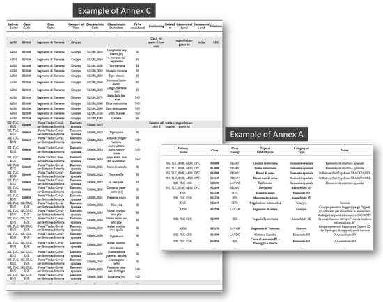
Figure 2.
Example of C.I. Annexes.
Annex B, on the other hand, concerns the coding of those typologies through the knowledge and location of the assets and all external elements related to the railway infrastructure, which are fundamental for the management of financial investment in safety, maintenance, and so on. The assets themselves concern the components that make up the railway (the track, signal, etc.), whereas the external assets are owned by third parties, and generally consist of overpasses, crossing points of overhead lines, and elements that involve the territorial conditions that may affect the infrastructure, such as landslide slopes and areas of possible flooding. All these things are cataloged and located in the InRete2000 system, a platform that allows technicians to manage the objects registered within the related database with specific census data and standard specifications of the asset in question. It is used by the RFI partner on the project for management of activities, including but not limited to, maintenance. Assets are characterized by a unique code (called the Sede Tecnica) that allows the association and connection of position, function, or process, and which is used to represent a system, a part of it, or a collection of logically groupable pieces of rail equipment. The levels of the codes of the census structure allow hierarchical identification of the composition and structure of individual pieces of rail equipment as they undergo various processes (e.g., maintenance). These Sedi Tecniche, which are geographically localized objects, are used for the census of assets according to a census reference structure, which, below each initial level, presents a tree structure with a hierarchy that can reach up to a seventh level of association. Knowledge of this structure must begin from the analysis of the second levels, which identify significantly relevant subsystems or parts of the infrastructure. The levels below the second represent objects that can be logically grouped below it. Some Sedi Tecniche function as “containers” of similar underlying objects, whereas others function as “aggregators” of several different objects. Annex C defines the requirements given the specific LOIN (Level of Information Need, in accordance with EU UNI 17412-1), with geometric specifications, such as positioning, as well as other information regarding the evaluation of certain expected specifications (see Figure 2). Meanwhile, Annex D contains the rules and admissible values for the specifications related to the context and the maintenance management systems (e.g., InRete2000) analyzed for each type of asset. In defining the requirements, it also took into account the system used by EAV (i.e., LINFE), the other partner on the project, to maintain the railway infrastructure, as well as the management of entities relating to the railway infrastructure. Similar to the InRete2000 system defined above, LINFE offers a complete overview of the infrastructure assets related to railway superstructure, electric traction, telecommunications, and others, managing each of them through a series of digital data sheets containing individual data, maintenance data, georeferences, and other links to documents. The modeled BIM objects were consequently created in accordance with these requirements from geometric, informational, and documentational perspectives. The C.I. with its related annexes was considered an essential reference for BIM modeling and information management activities in the context under analysis. The information requirements regarding the BIM objects, and therefore the BIM models as well, were met, following definition of the specific Level of Information Need, by deciding on an appropriate digital strategy that exploits the openBIM approach and related standards (e.g., IFC). The capabilities offered by BIM models, in open format, allowed us to satisfy these requirements (e.g., Level of Information Need), for instance through the development of specific PSets associated with the IFC classes considered for the digitalization of the railway infrastructure.
2.2. Organisation of Survey Activities
The project activities took into account the extension of the entire railway infrastructure (around 47 km) in trying to define a methodological approach concerning the construction of the BIM object library, and above all, the definition of the digital infrastructural model concerning the development of the geometric, information (e.g., PropertySet), and documentational (technical documentation, diagrams, layouts, and more) components of required LOINs, for the management of operations and maintenance in the broader context of asset management. The railway infrastructure, which is currently in operation, is characterized by technical complexity due to its numerous components. Drones and an autonomous survey vehicle were used for survey activities. To carry out these activities, we considered, among other things, how railway traffic impacts the line, weather conditions (rain and wind), accessibility to surveyed sites, and transport problems. The university (Federico II), through a multidisciplinary research team, dealt principally with the survey phases, and used various instruments, including drones, specifically a DJI Mavic 2 Enterprise Dual. This is an easily transportable instrument, extremely light, and equipped with a high-resolution camera stabilized by a three-axis gimbal that provides digital and mechanical cushioning of the framing. Taking into account flight autonomy (around 30 min) and maximum speed (around 70 km/h), each flight was planned and defined for a given asset (areas and buildings related to railway stations and bridges) and radio-controlled from the ground (via a DJI Smart Controller). From these surveys, point clouds and textured meshes were initially obtained for the various stations, certain bridges, and viaducts. This information was used to construct the BIM object typologies and BIM information models, as well as to enrich the final federated digital model in a collaborative platform. Due to the availability of an autonomous railway vehicle (belonging to an exterior contractor appointed by the railway operator to survey track infrastructure) that was equipped with specific instrumentation (a laser scanner, GPS, an inertial platform, among other things), it was possible to acquire videos and photos, create point clouds, and more, along the entire line (see Figure 3). This innovative system is dedicated to rail systems: its wide range of tools is placed on a single vehicle, giving us a mobile rail-mapping system that involves various detection technologies, including laser scanners, georadar, thermo-graphic imaging, and a high speed/resolution digital camera. It allows us to carry out continuous activity (average speed 15–30 km/h), acquiring information in terms of point clouds, photos, etc. These can be post-processed to obtain, as in the present case, the alignment of the infrastructure (e.g., 3D polyline), including information about the geometry of the railway track and sections, as well as other information.
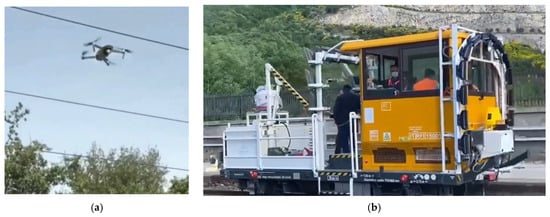
Figure 3.
Surveying equipment engaged for existing condition acquisition of railway line: (a) drones; (b) autonomous railway vehicle.
All the collected data were integrated into a single collaborative environment for the management and maintenance of the infrastructure.
2.3. Stages of the Proposed Digital Solution
Digital management of the entire railway infrastructure allowed us to develop BIM-based procedures for the maintenance and management phases of the railway line, which were realized by means of BIM modeling of existing conditions and the integrated management of information in the context under analysis. The digitalization strategy, shown in Figure 4, was proposed accordingly.
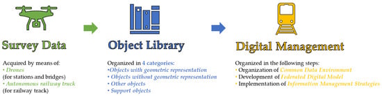
Figure 4.
Definition of a digitalization strategy for existing railway infrastructure.
The methodology and technical solution (developed in collaboration with ACCA Software) adopted for the construction and management of the proposed digital solution (federated BIM model) for the existing railway (around 47 km) involved the use of IFC4x2, the latest version of IFC available at the time the project activities were carried out. In this version [], reference was made to the concept of alignment of linear infrastructure (IfcAlignment) and positioning of objects along the infrastructure alignment (IfcLinearPlacement). At the same time, it should be specified that in regard to the concept of alignment, information is not yet completely available to the user, i.e., by means of the BIM software currently available on the market. Therefore, with the aim of offering an operational solution to the railway company responsible for the line, but based nonetheless on the innovative concepts outlined above, and with the aim of making this alignment information available to the stakeholders, a “fictitious” model relating to alignment was created. This model is characterized by horizontal and vertical geometry and consists of specific segments with associated and defined PropertySets that convey information about the geometric path that is both planimetric (e.g., curve radius, slopes, etc.) and altimetric (e.g., levels, superelevetion, etc.). For the realization of the library, we digitally reproduced various BIM object typologies (corresponding to 3D elements, groups, assemblies, etc.) that were typical of the railway infrastructure in question, and in accordance with the information requirements that had been requested and specified (in terms of geometry, information, and documentation) in the Annexes to the C.I. Surveys and other information were then used to define a BIM objects library, in other words, generic entities represented through BIM objects. These were produced considering the use of open formats (IFC, csv, etc.). This was proposed with the aim of allowing the owner or manager of the infrastructure to choose from among the many kinds of software that support these types of formats, without being limited to any one of them. The development of typologies (i.e., BIM objects) also involved the definition of four categories: (i) typologies with geometry; (ii) typologies without geometry; (iii) other typologies; and (iv) support typologies. The first category is characterized by a specific geometry with related information (such as PropertySet) and documents in accordance with the requirements of the C.I. Annexes. The second category, meanwhile, does not have a reference geometry, but only takes into consideration the appropriate information, namely, PropertySet and its related properties, associated with aggregations, zones, systems, and so on, developed according to the logic or practices of maintenance and asset management following the requirements of the C.I. Annexes. The third category concerns elements that are not considered by the C.I. and its Annexes, but which have to be considered for the development of the whole digital model of the infrastructure. Finally, the support typologies are simple graphic models used to support the creation of the typologies in the previous categories. Specifically, two types of properties (associated with type object and related occurrence) were associated with each BIM object. The type object properties are covered by Annex D to the C.I., and also regard other requirements or procedures relating to the managing entity (e.g., RFI), which include various specifications associated with the elements in the model. For instance, in relation to the typology “sleeper segment”, properties will refer to the type of sleeper, the number of sleepers, sleeper length, and so on. Meanwhile, the instance (or occurrence) properties are associated with all occurrences of BIM objects within the BIM model. They report information relating to the census codes of the given asset in accordance with the various maintenance management systems in question. This code refers to the generic asset that has been registered, and which has to be maintained. Some of the codes relating to the reference structure are given in Annex B, and are subsequently evaluated following the logic provided by the maintenance management system (e.g., LO1336-BC-BC01-DEV for a specific BIM object related to “railway switch” typology). The PropertySets proposed here have been developed to transmit information and create correspondence with the maintenance management systems (InRete2000 for RFI and LINFE for EAV). This information constitutes a sort of “information bridge or link” between the ERP systems used for maintenance management. With the approach taken in future by openCDEs, it may be possible to automate the updating of values taken directly from the designated systems (e.g., ERP platforms) with regard to the properties defined within the BIM models and related objects. An example of these properties, regarding the “railway signal” typology, is given in Table 1 and Table 2.

Table 1.
Example of defined type object properties with regard to the “railway signal” typology.
Table 2.
Example of defined occurrence properties with regard to the “railway signal” typology.
So far as the construction of the digital model of the infrastructure is concerned, individual disciplinary models were developed (railway superstructure, civil engineering works, signaling, etc.), as well as sub-models (such as rails, sleepers, etc.) and other subdivisions following the census and maintenance logics, and aimed at defining information management strategies.
In sum, this project is an application of openBIM to the O&M (operation and maintenance) phases of the railway asset lifecycle. In this scenario, the proposed solution was implemented on a real case of an existing operational railway. Successively, this application also allowed us to make important considerations in the context of asset management, evaluating the real financial and operational value of infrastructure in order to define possible investments necessary to make the infrastructure compliant with RFI standards. All this was supported by the creation of a specific CDE organized into several folders, each of which was given specific permissions and workflows. This CDE, created within the collaborative environment used for the project (usBIM.platform), was where the owner of the railway and all the other participants in the project could collaborate through the use of workflows organized with the aim of keeping track of overall progress in relation to the allotted time, and following the process map shown in Figure 5.

Figure 5.
Process map related to the pilot project activities.
In order to capture existing conditions, the railway infrastructure manager commissioned various actors (among them the University of Naples and an outside contractor) to survey the railway, as well as a number of bridges, tunnels, and stations belonging to it. As anticipated, this allowed us to obtain a series of images, point clouds, and textured meshes, among other things. One of the outputs of the survey phase was the geometrization of the railway track. This was loaded into the CDE environment, and this information, which related to the track and other assets along the line, provided the input for the BIM modelers to realize BIM models and create the library of BIM objects. For each object, a specific geometric representation was provided, along with other information requested by the railway specialists, and was transmitted by means of properties, for example. The object library was subsequently uploaded to the CDE as well, with the aim of being reused for future projects. This, together with the geometrization of the existing track, gave the inputs for the modeling of the railway line using a specific tool developed for the project (i.e., usBIM.IFCinfra). The IfcAlignment and IfcLinearPlacement concepts, which are typical of the linear infrastructure domain, were used with the aim of creating the alignment and positioning the railway objects (e.g., signals) along it. The models approved by the railway specialists were subsequently uploaded to the CDE along with the point clouds, 360-degree photos, and all relevant documentation (technical reports, maintenance forms, layouts, etc.), in order to obtain a single federation of all available information referenced in IFC models. In addition, the various typologies were associated, as anticipated, with properties that play a central role in asset management and integration with the existing maintenance management systems of the railway owner (e.g., ERP platforms). Finally, the results of the project gave the input for the (real) management workflows of the existing railway infrastructure. The railway owner was therefore able to test the accuracy of the modeling activities that had been obtained from surveys and the geometrization of the track; just as important, however, was that an entire process had been developed for carrying out the project activities. Various actors with specific skills had collaborated to achieve the project objectives. The railway experts, appointed by the railway operator, defined the requirements and levels of information necessary for the various assets under consideration. The BIM modelers, meanwhile, used tools and technologies for infrastructure modeling, and considered concepts such as IfcAlignment for modeling the railway track, IfcLinearPlacement for positioning objects along the track, and IfcSweptAreaSolid to extrude solids along the railway track. The BIM modelers also complied with the requirements and relevant LOIN.
2.4. Software Ecosystem Definition to Support Project Activities
A specific solution was developed to support the project activities in collaboration with the software provider (ACCA Software). It was possible to build the digital model of the railway structure by modeling the BIM object typologies with BIM-authoring software (e.g., Edificius). Specifically, we used a non-commercial version in development related to infrastructure modeling, which had been made available by the software provider for the purposes of the project. Its integration with other tools (e.g., Blender and SketchUp) was also exploited for the geometric modeling of complex parts. Furthermore, it emerged during the project that BIM-authoring tools alone are insufficient for managing all the information relating to the railway infrastructure (approximately 47 km). Consequently, it was necessary to use collaborative platforms for the integrated and federated management of all BIM models and other information relating to the infrastructure. This solution can also be applied operationally to other existing railway lines managed by the railway operator. To address and manage the complexity of these activities, the authors, in collaboration with ACCA Software, a company active in the development of openBIM-related software, developed a solution that was tailor-made for the aims of the project. This consisted of the creation of usBIM.IFCinfra. This tool made it possible to manage the modeling of infrastructure (railway superstructure, electric traction, etc.) by providing as input (through the development of databases, such as Excel sheets) information relating to the railway infrastructure (e.g., positions of elements such as poles, ports, and signals), as shown in Figure 6.
Figure 6.
Example of input (e.g., Excel sheets) for modeling activities related to the positioning of some BIM objects (e.g., poles).
The tool that was created thus made it possible to produce a state-of-the-art model based on the modeling techniques of the IFC specifications, such as the use of alignment and the positioning of various BIM objects along the line. This tool implements IfcLinearPlacement, which defines the positioning and direction of the axes of the coordinate system for objects by referring to a curve, for instance IfcAlignmentCurve. The implementation of IfcLinearPlacement ensures that the positioning of objects along the railway line (IfcAlignment) is organized, with the reference information given in terms of kilometers and the relative offsets of the objects in question. More precisely, a positioning function was used, by means of specific algorithms, in which each object was characterized by three pieces of information: longitudinal distance, vertical offset, and lateral distance from this. Indeed, based on specific inputs (e.g., Excel datasheets) characterized by specific information (e.g., kilometers, vertical, and horizontal offsets, orientation, and object type), these algorithms allowed us—among other things—to automate the positioning along the infrastructure alignment of specific and recurring BIM objects, such as poles and railway signals, thereby avoiding the manual positioning of single objects within a single BIM model. The various BIM objects (occurrences of the objects proposed by the library) were positioned accordingly.
The alignment that was obtained (also in landXML format) and the object library were useful inputs for the BIM modeling phases of both the components and the railway infrastructure. Using the survey data that had been obtained (such as point clouds), tags or flags were defined with the aim of highlighting the specific coordinates relating to the positioning of a given object. The BIM models of the infrastructure were created in accordance with a modeling plan developed for the project (e.g., subdivision of the line into about 21 IFC models). For the modeling of some infrastructural components (such as rails, ballast, and tunnels), another important concept was IfcSweptAreaSolid, which could be used to extrude the profiles of the elements considered along the alignment through its implementation in usBIM.infra. Once the individual IFC models of the planned infrastructural parts had been obtained—with these created starting from the alignment as a common reference, which was previously uploaded to the used software—they were then uploaded to usBIM.platform (the collaborative platform for the management and coordination of project workflows), where they were federated together with point clouds, 360-degree photos, textured meshes, and all other information (alphanumeric and documentary) available. Thus, a single federation of the railway infrastructure model was produced to ensure the secure storage of information and avoid its dispersion over time. Examples of digital management, selected from the federation in question, and regarding certain stations, overpasses, tunnels, and railway superstructure along the line, are given in Figure 7.
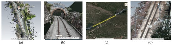
Figure 7.
Examples of digital management of the railway infrastructure in question (Cancello–Benevento line) for (a) stations; (b) overpasses; (c) tunnels; and (d) railway superstructure along the line.
The various IFC models that were created, with reference to the various disciplines being considered, and associated with PropertySets useful for the management of maintenance, make possible connection and correspondence between the elements to be maintained, which is managed through a maintenance management system (e.g., InRete2000 or LINFE). This solution, which began with a survey of existing conditions, can be used for the operation and management of maintenance, or for financial evaluations in the wider context of asset management. Since the BIM objects proposed by the library are obtained beginning with an analysis of the specific needs of the given context, the related properties also have the purpose of providing information as a part of asset management, and with the aim of integrating maintenance management systems (e.g., ERP platforms). This information will then be handled by railway specialists in the relevant maintenance sector. The solution was conceived entirely in openBIM, and thus involves the use of open formats and procedures (principally based on IFC). The software ecosystem is described in Figure 8.
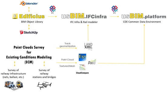
Figure 8.
Software ecosystem considered for the digital management of the railway infrastructure.
In addition, the project involved the use of the semantics (e.g., classes) offered by the version we used, namely IFC4x2, the latest available at the time of the project. This obviously has limits and deficiencies, mainly from a semantics point of view, which will certainly be improved by the next IFC version (probably IFC4x3), which will also integrate the developments made in the IfcRAIL project. This will enable more accurate IFC mapping of various railway elements (rail equipment, electric traction, signals, etc.), as well as specifications of the spatial structures most relevant to infrastructure.
3. Results
In the context of the pilot project, the selected case study considers an existing railway line that consists of a simple track that extends around 47 km (see Figure 9). This line includes 12 stations, the first of which is “Cancello”, and the last “Benevento”. These two are under the management of RFI, whereas all those in between are managed by EAV.
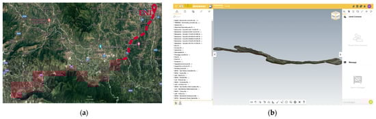
Figure 9.
The railway infrastructure considered for the project activities (Cancello–Benevento line): (a) geographical context; and (b) federated digital model managed in the collaborative platform.
From an infrastructural perspective, the single-track line is characterized by a standard railway gauge (1435 mm) with different kinds of sleepers (single block, bi-block) made from various materials (wood, concrete, etc.). The rails along the entire line are of the 50 UNI type. The railway superstructure consists primarily of continuously welded rails, specific ballast crushed stone, and sleepers spaced at around 60 cm apart. There are also two types of switch boxes (Westinghouse M4 and FS L88). Furthermore, along the railway line, there are around 56 level crossings (protected and unprotected by barriers) and 15 viaducts, overpasses, and steel bridges with spans greater than or equal to 3 m. There are six tunnels, of which two are shorter than 40 m, three are shorter than 500 m, and one is 816 m long. In regard to electric traction, the contact line generally consists of a fixed 120 mm2 supporting cable and two 100 mm2 contact wires adjusted with a specific pull, giving a total cross-section of 320 mm2, with the exception of certain sections in which the overall cross-section is 220 mm2. The majority of the poles along the line are type LSF, except in certain sections where they are type M (Mannesmann). All the stations along the line are delimited from an electrical perspective by TE portals. In the case of signaling, however, the distancing of trains from one station to another still takes place via telephone block.
As part of this project, it was possible to exchange information between the various organizations and actors involved through openBIM, thus meeting requirements such as interoperability. This was also possible due to the organization of a CDE on the platform that was used (i.e., usBIM.platform), where all the information (BIM models and objects, documents, point clouds, textured meshes, and more) was loaded. Prior to this, in order to carry out the surveying activities, numerous images and pieces of information relating to the sites of interest were acquired. These activities were carried out through the use of drones for all the bridges and stations under consideration, along with a mobile mapping system, specifically a multidimensional mapping system with detection and positioning instrumentation, all installed on a single vehicle. This permitted the dynamic survey of the track infrastructure, as well as the acquisition of various kinds of information (e.g., geometry, structural conditions). This acquired information could subsequently be integrated into a single environment to support the maintenance, design, and management phases of the infrastructure.
Meanwhile, a number of drone flights were carried out to survey the stations and bridges in question, and analysis and processing of the acquired images were subsequently necessary. As described above, drones and state-of-the-art instruments were used, with photogrammetric techniques then used to determine the outputs (point clouds and textured meshes) relating to large areas of the survey targets. These also made it possible to return information based on a large number of points (i.e., point clouds), each of which had its own data in terms of position and color, all to the benefit of the quality and quantity of the information to be obtained. In addition, from these acquisitions it was possible to extract information and measurements of all kinds, as well as to export subsequent data as dense point clouds, textured meshes, and more, in reference to the various formats under consideration. The survey flights were planned through the use of certain kinds of software (e.g., Pix4DCaptur), taking care to cover the entire area being examined by selecting appropriate trajectories (circular, grid, etc.), as shown in Figure 10. Regarding the processing of the images we obtained, which was performed with dedicated applications (e.g., Pix4D mapper), point clouds (.las format) and textured meshes (.fbx format) were both generated.
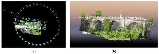
Figure 10.
Data acquisition and processing by means of usage of drones in the case of a railway masonry bridge: (a) processing of the images acquired considering different drone flight strategies; and (b) example of results in terms of point cloud.
Figure 11 and Figure 12 give examples of activities concerning the acquisition, elaboration, and definition of output (e.g., point clouds) from the surveys of, respectively, station buildings or railway stops, and some of the bridges, viaducts, and overpasses along the line.
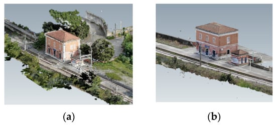
Figure 11.
Survey activity results in terms of point clouds (a) for a railway station and (b) for a railway stop.
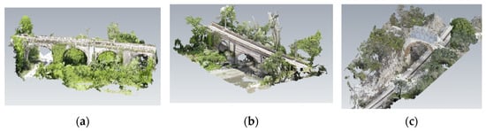
Figure 12.
Survey activity results in terms of point clouds for two bridges (case (a) and (b)) and one overpass (case (c)) belonging to a railway line.
These data were used as inputs for the BIM modeling activity, as defined in the previous section, and were subsequently divided into two phases. In the first of these, the railway superstructure was modeled (sub-ballast, ballast, sleepers, rails, etc.), and this provided the reference for carrying out activities in the next phase. For instance, the BIM modeling for sleepers and rails was organized by considering the relative census and maintenance logics (e.g., sleeper segments and rail segments) implemented in the maintenance management systems under consideration. For the organization of the relevant BIM models, the correct positioning of the elements along the line was also taken into account by means of tags positioned within point clouds (e.g., different sections with different types of sleepers). The second phase, meanwhile, called for the insertion of the remaining typologies along the line.
Throughout the course of the project, we created various BIM object typology representations along the railway line in relation to railway superstructure, electric traction, civil engineering works, and part of signaling and telecommunications. By this virtue, it was possible to define and organize a library of BIM objects, as defined above (Section 2), by framing the various characteristic elements of the railway infrastructure in question under the typologies called for by the C.I. (3D elements, groups, assemblies, etc.). An example of an object belonging to the first typological category, “BIM object with geometry”, with dedicated PropertySets, is shown in Figure 13. These properties are intended to transmit information and create correspondence with maintenance management systems (for instance LINFE for EAV, or InRete2000 for RFI). In this case, a railway signal is shown. This approach has also been proposed for other typologies of the same category but belonging to other disciplines.
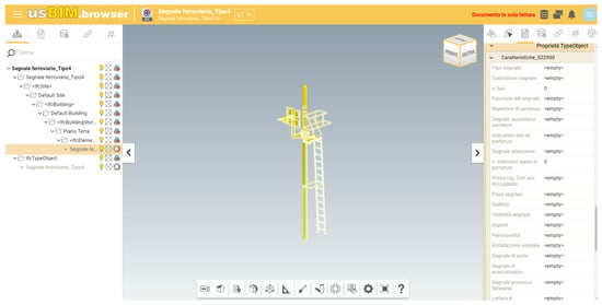
Figure 13.
Example of BIM object belonging to category “BIM object with geometry” (e.g., railway signal) and its properties.
Regarding the second category, “BIM object without geometry”, since these are represented only by properties to be associated with aggregations, elements of spatial structure, zones, systems, among other things (through IFC classes such as IfcGroup, IfcSpatialStructureElement, IfcZone, IfcSystem, etc.), a given open format (.csv format) was used for the definition and subsequent association of all the specific properties regarding the typology in question, as required by the Annexes to the C.I. These properties were then associated with their respective entities within the BIM model of the infrastructure. Figure 14 shows a representative example for this category, namely, the “rail segment”. This approach was also proposed for other typologies belonging to different disciplines (railway location, track segment, stations, section insulators, etc.).
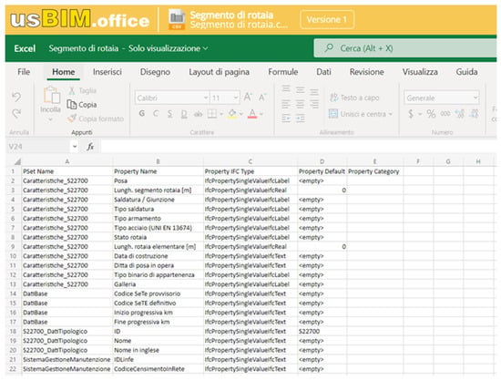
Figure 14.
Example of BIM object belonging to category “BIM object without geometry” (e.g., rail segment).
So far, as the third category is concerned, namely “other BIM objects”, Figure 15 gives an example of a pole (Mannesmann type) and its associated properties.
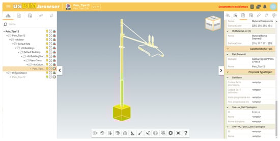
Figure 15.
Example of BIM object belonging to category “other BIM object” (e.g., Mannesmann pole) and its properties.
Finally, regarding the fourth category, “support objects”, i.e., graphic objects that aid construction of the previous categories, Figure 16 gives some examples (e.g., sleeper typologies).
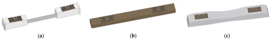
Figure 16.
Example of BIM object belonging to category “support objects” (e.g., sleeper with its types (a) bi-block (p.s.c.); (b) single-block (wood); and (c) single block (p.s.c.)).
Once the library containing the various typologies of BIM objects for the individual disciplines had been built, starting from these and the survey data, the informative models were created (around 21 IFC models). The digital model of approximately 47 km of the railway infrastructure was created using openBIM standards (principally IFC). It was possible to create a federated model through usBIM.platform, which enabled us to combine and manage a large amount of data within the same environment (e.g., Common Data Environment), including models, point clouds, textured meshes, and documents. As mentioned above, for the development of IFC objects and models, we used IFC4x2, which made it possible, for instance, to contain alignment information within the IFC file. Unfortunately, this information is not yet usable by users, who must extract it from the IFC file. For this reason, as already mentioned in the previous section, it was necessary to create a “fictitious” model for the alignment, in order to make this information available, usable, and operational to stakeholders. This solution made it possible to have 3D reference geometry (divided into various sections), to each of which specific PropertySets were associated, defining information about geometric measurements (track length, minimum height, etc.), elements themselves (curves, transitions, etc.), and all the other characteristics associated with them. Within the collaborative platform, it was also possible to update property values and documents, find any information relevant to maintenance operations, and add or federate new information (models, point clouds, etc.). This kind of approach was developed with the aim of later making this management solution integrated and interdisciplinary, through the future technology of “open CDEs”, thus promoting interoperability and connection between the various systems involved (BIM-authoring, collaborative platforms, ERP systems, etc.). The project’s entire process was coordinated by project managers appointed by the railway owner, who were monitored directly within the BIM environment, where the workflow functionalities were used to assign tasks and requirements to the various participants in accordance with established deadlines. For the linear positioning of the objects regarding alignment, as required by IFC standards, and now using IfcLinearPlacement, there is a need to refer and position individual objects in accordance with the alignment with respect to a triad of axes (x, y, z) concerning the IfcLocalPlacement concept. Given this requirement, it was necessary to pass from one reference system to another, namely from the data obtained as absolute coordinates (X, Y, Z) to the information in the relevant system (s, x, y), where s indicates the longitudinal distance from the start of the alignment, and x indicates the lateral offset, and y the vertical offset of the point being considered. Figure 17 shows the digital solution adopted for alignment. The geometrized track was modeled as a three-dimensional BIM object with its respective associated properties (representative of certain information, such as initial radius, transition type, and section length).
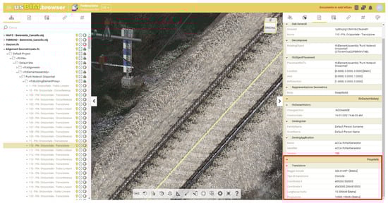
Figure 17.
Example of BIM model for an alignment segment with specific properties.
Regarding the construction and organization of BIM models, on the other hand, the IfcGroup class was widely used, as well as the subclasses of IfcElement (IfcZone, IfcSystem, etc.). For the structuring of the BIM models in relation to the census logic, various groups of objects were organized. These groups reflect the relative organization of the assets that had been censused, and which would therefore be maintained in the management system (e.g., InRete2000 or LINFE) used by the owner or operator of the infrastructure in question. Figure 18 gives an example relating to some instantiated BIM object typologies, such as ‘rail segment’ or ‘sleeper segment’, along with their relative properties.
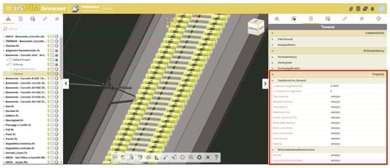
Figure 18.
Example of using the IfcGroup concept with specific properties.
Figure 19 gives an example of a federated view of various digitalized assets, with the tunnel, railway superstructure, electric traction, and surrounding environment represented through IFC models, point clouds, and textured meshes that are all usable within the CDE on the platform we employed. Each tunnel, as with any typology present along the line, is also associated with specific PSet and relative properties (e.g., with reference to certain characteristics such as length, type, material, and structural type).
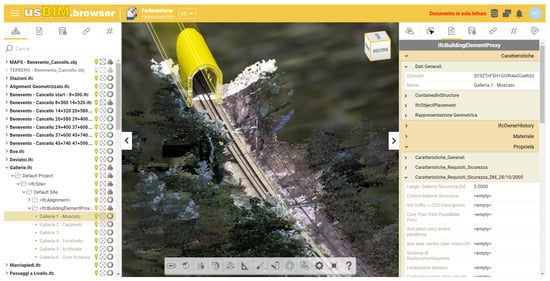
Figure 19.
Example of a federated view regarding a tunnel along the line (IFC models with specific PSets, point clouds, etc.).
The activities regarding the survey and modeling of the current condition of railway infrastructure resulted in the management of a large amount of relevant data. This consisted of around 230 GB, including point clouds and textured meshes (for bridges and stations under investigation), 21 IFC models (relating to the subdivision of the railway infrastructure by discipline and section (as required by the modeling plan built ad hoc for the project’s aims)), 73,113 digitized layout elements (sleepers, rails, etc.), 50 level crossings, 6 tunnels, 1159 poles, 26 ports, and 804 railway signals.
Regarding the validation of the project in terms of verifying objects and BIM models, while the information was being produced (library objects and models), as stipulated in the C.I. (in accordance with the rules and specific LOINs defined to meet the information requirements of RFI and EAV), digital workflows were produced in the collaborative environment to be used in the validation, approval, and publication of the models and documents in the collaborative platform (usBIM.platform) by the actor in charge (in this case the university, though in future this will be some generic figure charged with the role). Starting from the specifications defined in the C.I., roles and specific authorizations (read-only, execution, etc.) were defined for each actor involved in the project within the collaborative environment. In this way we could represent the activities to be carried out regarding the various files, folders, notifications of tasks, and management of permissions associated with each of the entities involved. Consequently, the development and digitalization of aspects of the process and its related activities resulted in the optimization of the performance of the various validation processes (previously uncoordinated and not managed on digital models), and also made the use of resources more efficient. Through these organized workflows and planned activities, stakeholders were able to keep track of the progress of the project. Figure 20 gives an example of the implementation, used subsequently for project activities, of a digitalized process (i.e., workflow) for the verification of models and other files, as well as their approval and publication in the CDE.
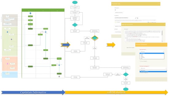
Figure 20.
Example of process digitization (e.g., regarding the validation process of the information content) carried out in collaborative platform according to C.I. specifications.
The digital solution we proposed for the management of the railway infrastructure in operation made it possible to effect quantitative and qualitative (or financial) evaluations of the railway assets, as shown in Table 3 and Table 4.
Table 3.
Quantifying of railway superstructure components related to existing line in question.
Table 4.
Type and number of objects along the considered railway line.
Based on these considerations, other considerations can be made regarding the merits of estimating the value and efficiency of a given railway asset. All this is an effective support for any interventions to be made along the line (as per project context). Having digitalized the entire line in the BIM environment, with reference to the various technological systems present, it was also possible to download and subsequently make calculations regarding the quantities obtained. The digitalization of this infrastructure also served as a reference for decisions relating to asset management, i.e., evaluating necessary investments, particularly regarding the takeover of management by another railway operator, namely RFI. Such investments must obviously be assessed in relation to the adaptation of the infrastructure to standards set by the new managing group.
4. Discussion
The use of openBIM, for instance, as applied to the management of the railway line described in this case study, enables collaboration, communication, and the exchange of information without restricting solutions to a specific software, thus ensuring integration of all professionals and their technical skillsets. This is made possible by the use of open formats (e.g., IFC). In this approach, IFC models act as “access keys” to information and processes related to other systems as well. It is this connection (regarding project information) between different existing ecosystems (CDE, CMMS, ERP, etc.) that gives the project added value. The project has demonstrated how the BIM modeling of existing conditions can be managed, but also how the CDE is the central point and unique source of information recording. This information is accessible to all actors at any time and place, and each of them has worked within the collaborative environment with various associated roles (visualization, editing, etc.) with the sole aim of participating in the digitalization of the existing railway line in accordance with the project’s predefined objectives. The openBIM approach is thus a new opportunity for business processes to be re-evaluated and reorganized, with time-consuming activities reduced through implementation within a single environment. In this way, information is managed effectively and organically, allowing both maintenance of the centralized railway infrastructure, relative to a single federated digital model, and improved performance analysis. Through the usBIM.platform, the owner or manager of the infrastructure can manage, check, and validate (in open format) the information required for the purposes of asset management of the railway infrastructure. Over the course of the project, a series of BIM object typologies belonging to the various technical disciplines were modeled, from which it was possible to build a library of BIM objects with the level of information required for asset management. This project’s activities can therefore be seen as a starting point, above all, at company level, since the spread and evolution of BIM methodologies and associated instruments can be a reference for similar projects in the future. In the present instance, the survey and modeling of existing conditions along the railway line allowed us both to obtain complete knowledge of the current technological systems and to evaluate the infrastructural gap to be closed economically and technically. The library and related geometrization of the existing layout were the necessary input for the realization of the digital model. The innovative management of concepts relating to the alignment and positioning of objects, along with other things typical of railway infrastructure, was made possible through the use of specific software developed for the case at hand. This permitted the production of BIM objects and models in accordance with the specifications of IFC4x2, the latest version in bSI available at the time of the project. The proposed approach also required the development of dedicated software solutions (e.g., usBIM.IFCinfra) for the modeling of information relating to the railway infrastructure in IFC4x2, supporting the development of BIM models through the management of innovative concepts (IfcAlignment, IfcLinearPlacement, etc.). The use of these open formats certainly has advantages in the management of information at company level, since it allows us to define the information requirements in compliance with national (e.g., UNI1137) and supranational (e.g., ISO19650 and EN 17412) standards, in order to create advanced digital knowledge, as well as to enable the control and elaboration of information specifications that both the design and, above all, the future maintenance of the infrastructure will depend upon. As stated previously, the project required the definition of specific information (e.g., PSet) dedicated to asset management, which is of considerable strategic and operational interest to the organization managing the infrastructure. At the same time, further development of openBIM is undoubtedly necessary for the asset management of railway infrastructure, as far as the availability of specific standardized PropertySets is concerned, which convey information necessary for the management of relevant activities. Regarding the IFC standard, the future availability of a specification relating to infrastructure will enable the management of various aspects that are now allowed only marginally. The integration of the contents of recent projects (IFCBridge Project, IFCRail Project, etc.) in buildingSMART will contribute to the development of a version (probably IFC4x3) that is able to perform various necessary operations (IFC mapping, spatial structure, etc.). The development of other standards (e.g., bsDD, IDS) and approaches (e.g., openCDE) for integration with other systems or platforms could bring significant advantages in establishing increasingly open and interoperable information management for all actors involved. The stakeholders had the opportunity to equip their company with the digital solutions that had been developed and the practices that had emerged for managing all relevant information by means of open formats (for the managing of models, objects, point clouds, documents, etc.) in a common digital environment (i.e., CDE), thus developing a solution for the easy management of around 47 km of existing railway line. Obviously, the research and experimentation, carried out downstream of the pilot project, has demonstrated considerable advantages in the optimized management of resources, materials, and company know-how, as well as coordination activities taken as a whole. As a result, the managing companies will be able to organize appropriate company areas for the tasks of optimizing the processes related to maintenance of the railway infrastructure and keeping all the information within the collaborative platform constantly updated, ensuring they have at their disposition data that is always current and usable, which is provided by all technicians involved in maintenance and infrastructure management. The digitalization of this in-operation infrastructure has also been of use as a reference for decision making in asset management, i.e., in evaluating required investments.
5. Conclusions
This pilot project stemmed from the need of a railway owner to manage its operations and assess the condition and value of its railway infrastructure. The principal objective was to systematize information by digitalizing the infrastructure, thereby allowing assessment of any performance gaps with respect to RFI standards. The digital management strategy proposed and implemented in this case study demonstrated the effectiveness of our proposal. It had the objective of supporting the decision-making process and at the same time assisting and managing the daily activities of management, operation, and maintenance of the railway’s assets. OpenBIM demonstrated that it supports the exchange of information between all actors involved in the process, and showed the ability to support the digitalization and management of the railway infrastructure for the purposes of managing the lifecycle of assets by supporting information connections with other systems (e.g., inRETE2000 and LINFE). At the same time, there remains a need for a specific IFC dedicated to infrastructure that can integrate the domain of railway infrastructure from both a geometric and semantic perspective. The digital solution we proposed also made it possible to form quantitative and qualitative estimates of the value of the infrastructural assets present along the railway. These considerations can determine assessments of the assets’ efficiency and support the decision-making process in any interventions to be carried out along the line (as per the project’s objectives). However, it should be added that from a sustainability perspective, the potential of BIM methodologies in the management of large amounts of data also allows the introduction of Life Cycle Impact Assessment information (LCIA) within BIM objects to be considered. By developing informative models related to civil infrastructure using BIM objects that integrate LCIA information, it will also be possible to have a general LCA balance of the project. This will allow more complete and efficient management of the assets. In this regard, the authors will investigate, in future studies, the applicability of an all-encompassing approach, which can be applied to an increasingly efficient management of infrastructure assets. The results obtained from this pilot project have certainly offered important insights regarding the development of the IFC standard in the field of asset management, and, by improving the efficiency of railway infrastructure safety maintenance, concerning the possible definition of new practices for the corporate management of processes. This research project has shown that such solutions can be integrated and implemented to make the operation and safety of an existing railway infrastructure more efficient. The managing company will be able to use the results of the pilot project, as obtained through implementation of the proposed methodology in the Benevento–Cancello case study, to manage the entire railway infrastructure for which it has responsibility. Given the considerable efforts made towards implementation of this project, and its innovative nature with regard to the application of openBIM, the research team was nominated at the 2021 buildingSMART Awards and was one of three finalists in the “Asset Management using openBIM” category. The results obtained by the project with respect to project goals (e.g., infrastructure compliance with RFI standards and management and maintenance of the railway infrastructural asset) were very encouraging, and both companies, EAV and RFI, have learnt fundamental lessons, in particular, regarding possible future scenarios involving the use of digital systems and new technologies (based principally on openBIM), which can certainly optimize the management processes of railway infrastructure.
Author Contributions
Conceptualization, A.C. and D.A.; methodology, A.C., S.D.S. and D.A.; software, A.C. and S.D.S.; investigation, A.C., S.D.S., D.A., A.S. and M.N.; data curation, A.C., S.D.S. and D.A.; writing—original draft preparation, A.C., S.D.S.; writing—review and editing, A.C., D.A., A.S. and M.N.; visualization, A.C., S.D.S. and A.S.; project administration, D.A. All authors have read and agreed to the published version of the manuscript.
Funding
This research received no external funding.
Institutional Review Board Statement
Not applicable.
Informed Consent Statement
Not applicable.
Data Availability Statement
Not applicable.
Acknowledgments
The research project was chosen as a finalist in the category of “Asset Management using openBIM” for the buildingSMART Awards 2021 and it was presented at the Virtual Summit 2021 with the title of “Asset Information Management of an existing railway infrastructure in the openBIM scenario: the Cancello–Benevento line”. The authors would like to acknowledge the two railway managing authorities, “EAV” and “RFI”, for making available the documentation related to the case study (existing railway line Benevento-Cancello), which is currently in operation, and for allowing the implementation of the proposed solution on a real case. In conclusion, we would like to acknowledge “Acca Software” for the technological support about the development of openBIM solution targeted towards the goals of the pilot project.
Conflicts of Interest
The authors declare no conflict of interest.
References
- Akcamete, A.; Akinci, B.; Garrett, J.H. Potential utilization of building information models for planning maintenance activities. In Proceedings of the 17th EG-ICE International Workshop—Intelligent Computing in Engineering (ICE10), Nottingham, UK, 30 June–2 July 2010. [Google Scholar]
- Liu, R.; Issa, R.R.A. Survey: Common Knowledge in BIM for Facility Maintenance. J. Perform. Constr. Facil. 2016, 30, 04015033. [Google Scholar] [CrossRef]
- Eastman, C.; Teicholz, P.; Sacks, R.; Liston, K. BIM Handbook. A Guide to Building Information Modeling for Owners, Managers, Designers, Engineers, and Contractors, 2nd ed.; John Wiley & Sons: Hoboken, NJ, USA, 2021. [Google Scholar]
- Borrmann, A.; König, M.; Koch, C.; Beetz, J. Building Information Modeling: Technology Foundations and Industry Practice; Springer International Publishing AG: Cham, Switzerland, 2018; ISBN 9783319928623. [Google Scholar]
- Daniotti, B.; Della Torre, S.; Gianinetto, M. Digital Transformation of the Design, Processes of the Built Management Construction and Environment; Springer Nature: Cham, Switzerland, 2020; ISBN 9783030335694. [Google Scholar]
- Azhar, S. Building information modeling (BIM): Trends, benefits, risks, and challenges for the AEC industry. Leadersh. Manag. Eng. 2011, 11, 241–252. [Google Scholar] [CrossRef]
- Latiffi, A.A.; Mohd, S.; Kasim, N.; Fathi, M.S. Building Information Modeling (BIM) Application in Malaysian Construction Industry. Int. J. Constr. Eng. Manag. 2013, 2, 1–6. [Google Scholar] [CrossRef]
- Latiffi, A.A.; Mohd, S.; Brahim, J. Application of Building Information Modeling (BIM) in the Malaysian Construction Industry: A Story of the First Government Project. Appl. Mech. Mater. 2015, 773–774, 996–1001. [Google Scholar] [CrossRef] [Green Version]
- Latiffi, A.A.; Brahim, J.; Fathi, M.S. Roles and Responsibilities of Construction Players in Projects Using Building Information Modeling (BIM). In Product Lifecycle Management in the Era of Internet of Things; Bouras, A., Eynard, B., Foufou, S., Thoben, K.-D., Eds.; Springer International Publishing: Cham, Switzerland, 2016; pp. 173–182. [Google Scholar]
- Pasetto, M.; Giordano, A.; Borin, P.; Giacomello, G. Integrated railway design using Infrastructure-Building Information Modeling. the case study of the port of Venice. In Transportation Research Procedia; Elsevier B.V.: Amsterdam, The Netherlands, 2020; Volume 45, pp. 850–857. [Google Scholar]
- Bensalah, M.; Elouadi, A.; Mharzi, H. Overview: The opportunity of BIM in railway. Smart Sustain. Built Environ. 2019, 8, 103–116. [Google Scholar] [CrossRef]
- Pakhale, P.D.; Pal, A. Digital project management in infrastructure project: A case study of Nagpur Metro Rail Project. Asian J. Civ. Eng. 2020, 21, 639–647. [Google Scholar] [CrossRef]
- Arashpour, M.; Bai, Y.; Kamat, V.; Hosseini, R.; Martek, I. Project production flows in off-site prefabrication: BIM-enabled railway infrastructure. In Proceedings of the ISARC 2018—35th International Symposium on Automation and Robotics in Construction and International AEC/FM Hackathon: The Future of Building Things; International Association for Automation and Robotics in Construction I.A.A.R.C: Berlin, Germany; 2018.
- Wang, G.; Zhang, Z. BIM implementation in handover management for underground rail transit project: A case study approach. Tunn. Undergr. Technol. 2021, 108. [Google Scholar] [CrossRef]
- Kwon, T.H.; Park, S.I.; Jang, Y.H.; Lee, S.H. Design of railway track model with three-dimensional alignment based on extended industry foundation classes. Appl. Sci. 2020, 10, 3649. [Google Scholar] [CrossRef]
- Liu, B.; Cai, T. Application Analysis of BIM Technology in Metro Rail Transit Application Analysis of BIM Technology in Metro Rail Transit. IOP Conf. Ser. Earth Environ. Sci. 2018, 128, 012028. [Google Scholar] [CrossRef]
- Xu, X.; Wang, G.; Cao, D.; Zhang, Z. BIM Adoption for Facility Management in Urban Rail Transit: An Innovation Diffusion Theory Perspective. Adv. Civ. Eng. 2020, 2020. [Google Scholar] [CrossRef]
- Ait-Lamallam, S.; Yaagoubi, R.; Sebari, I.; Doukari, O. Extending the IFC Standard to Enable Road Operation and Maintenance Management through OpenBIM. ISPRS Int. J. Geo-Inf. 2021, 10, 496. [Google Scholar] [CrossRef]
- Yin, X.; Liu, H.; Chen, Y.; Wang, Y.; Al-Hussein, M. A BIM-based framework for operation and maintenance of utility tunnels. Tunn. Undergr. Space Technol. 2020, 97, 103252. [Google Scholar] [CrossRef]
- Floros, G.S.; Boyes, G.; Owens, D.; Ellul, C.; Engineering, G.; Street, G.; Park, V.B.; Management, A. Developing IFC for Infrastructure: A Case Study of Three Highway Entities. Integr. BIM-GIS Asset Manag. Infrastruct. 2019, 4, 24–27. [Google Scholar] [CrossRef] [Green Version]
- Shah, R.; McMann, O.; Borthwick, F. Challenges and prospects of applying asset management principles to highway maintenance: A case study of the UK. Transp. Res. Part A Policy Pract. 2017, 97, 231–243. [Google Scholar] [CrossRef]
- Gao, G.; Liu, Y.; Wu, J.; Gu, M.; Yang, X.; Li, H.; Third, T.; Survey, R.; Third, T.; Survey, R.; et al. IFC Railway: A Semantic and Geometric Modeling Approach for Railways Based on IFC. Available online: https://www.semanticscholar.org/paper/IFC-Railway%3A-A-Semantic-and-Geometric-Modeling-for-Gao-Liu/f5b262e7ee98dd556f1f244fd88e08bb0796547d (accessed on 2 February 2022).
- Costin, A.; Adibfar, A.; Hu, H.; Chen, S.S. Building Information Modeling (BIM) for transportation infrastructure—Literature review, applications, challenges, and recommendations. Autom. Constr. 2018, 94, 257–281. [Google Scholar] [CrossRef]
- Soilán, M.; Nóvoa, A.; Sánchez-Rodríguez, A.; Justo, A.; Riveiro, B. Fully automated methodology for the delineation of railway lanes and the generation of IFC alignment models using 3D point cloud data. Autom. Constr. 2021, 126. [Google Scholar] [CrossRef]
- Shalabi, F.; Turkan, Y. IFC BIM-Based Facility Management Approach to Optimize Data Collection for Corrective Maintenance. J. Perform. Constr. Facil. 2017, 31, 04016081. [Google Scholar] [CrossRef]
- Takikawa, M. Innovation in Railway Maintenance utilizing Information and Communication Technology (Smart Maintenance Initiative). Jpn. Railw. Transp. Rev. 2016, 67, 22–35. [Google Scholar]
- Cavka, H.B.; Staub-French, S.; Poirier, E.A. Developing owner information requirements for BIM-enabled project delivery and asset management. Autom. Constr. 2017, 83, 169–183. [Google Scholar] [CrossRef]
- Neves, J.; Sampaio, Z.; Vilela, M. A case study of BIM implementation in rail track rehabilitation. Infrastructures 2019, 4, 8. [Google Scholar] [CrossRef] [Green Version]
- Biancardo, S.A.; Viscione, N.; Cerbone, A.; Dessì, E. BIM-Based Design for Road Infrastructure: A Critical Focus on Modeling Guardrails and Retaining Walls. Infrastructures 2020, 5, 59. [Google Scholar] [CrossRef]
- Caldera, S.; Mostafa, S.; Desha, C. Exploring the Role of Digital Infrastructures Asset Management Tools for Resilient Linear Infrastructure Outcomes in Cities and Towns: A Systematic Literature Review. Sustainability 2021, 13, 11965. [Google Scholar] [CrossRef]
- Santos, E.T. Lecture Notes in Civil Engineering. In Proceedings of the 18th International Conference on Computing in Civil and Building Engineering, São Paulo, Brazil, 18–20 August 2020; ISBN 9783030512941. [Google Scholar]
- buildingSMART International IFC Specifications Database (IFC4x2 Version). Available online: https://standards.buildingsmart.org/IFC/DEV/IFC4_2/FINAL/HTML/ (accessed on 1 March 2021).
Publisher’s Note: MDPI stays neutral with regard to jurisdictional claims in published maps and institutional affiliations. |
© 2022 by the authors. Licensee MDPI, Basel, Switzerland. This article is an open access article distributed under the terms and conditions of the Creative Commons Attribution (CC BY) license (https://creativecommons.org/licenses/by/4.0/).