Correlation between Building Damages and Losses with the Microzonation Map of Mataram—Case Study: Lombok Earthquake 2018, Indonesia
Abstract
1. Introduction
2. Materials and Methods
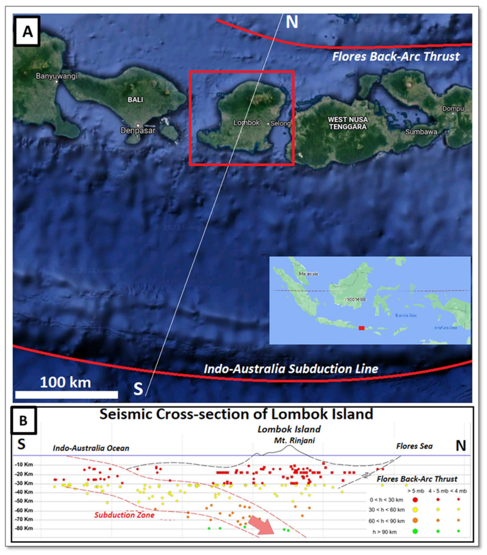
2.1. Study Area
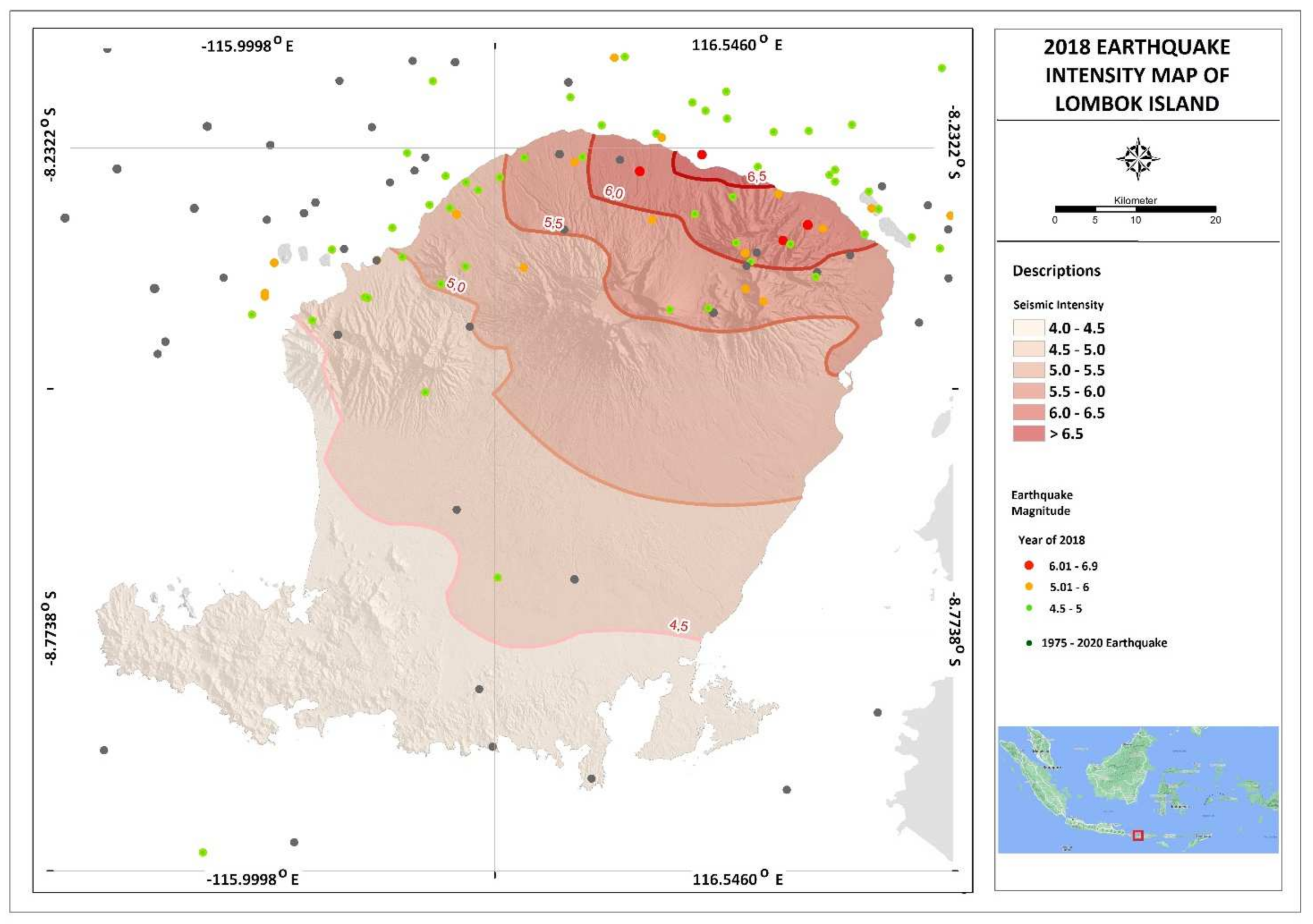
2.2. Damage and Loss Due to the Mataram Earthquake in August 2018
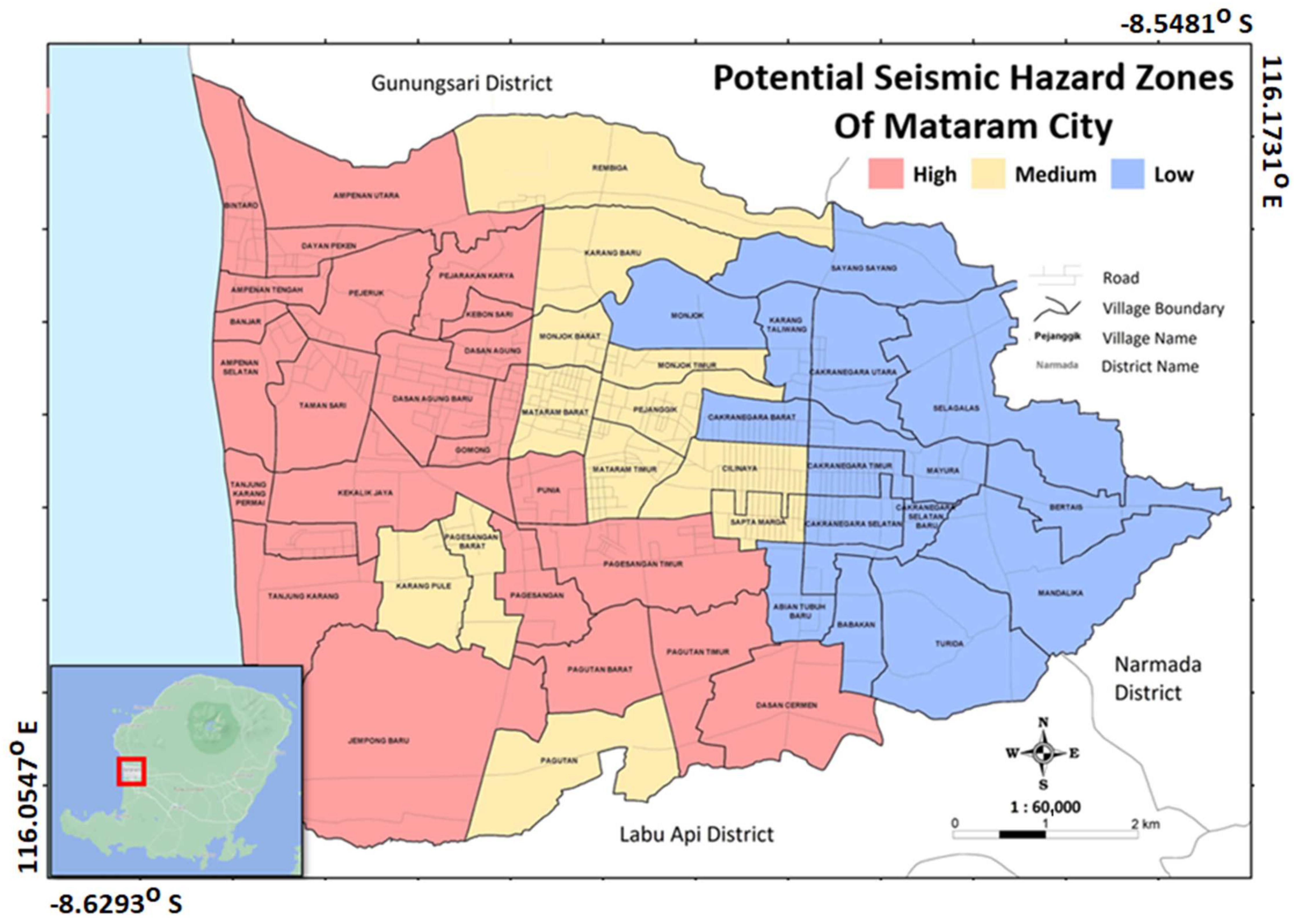
2.3. Microzonation Map
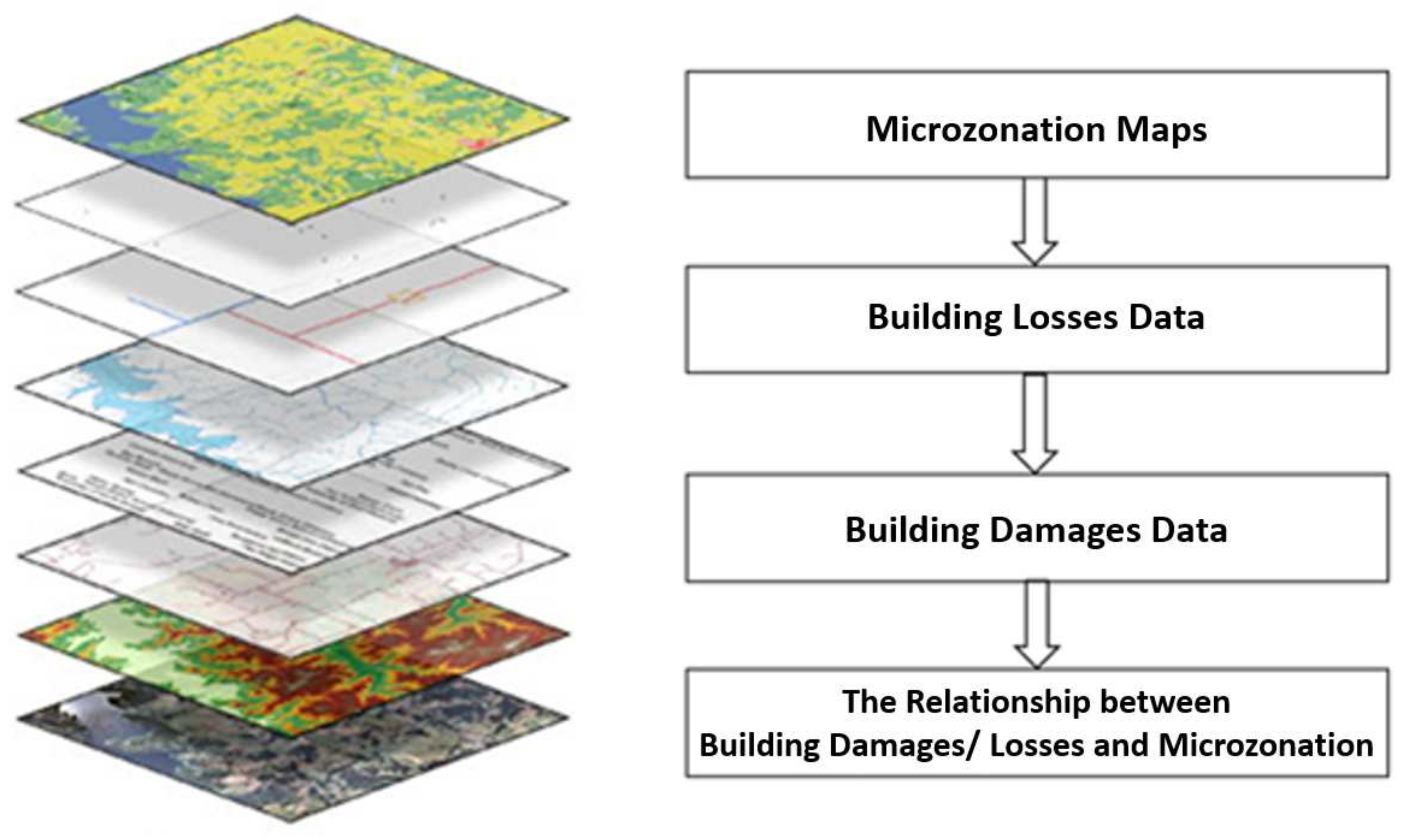
2.4. Worksteps
- i = microzonation units
- j = loss damage data values
- z = variable in the source zones
- ij = overlapping target zone
3. Results
4. Discussion
5. Conclusions
Author Contributions
Funding
Institutional Review Board Statement
Informed Consent Statement
Data Availability Statement
Acknowledgments
Conflicts of Interest
References
- Lüschen, E.; Müller, C.; Kopp, H.; Engels, M.; Lutz, R.; Planert, L.; Shulgin, A.; Djajadihardja, Y.S. Structure, evolution and tectonic activity of the eastern Sunda forearc, Indonesia, from marine seismic investigations. Tectonophysics 2011, 508, 6–21. [Google Scholar] [CrossRef]
- Ramdani, F.; Setiani, P.; Setiawati, D.A. Analysis of sequence earthquakes of Lombok Island, Indonesia. Prog. Disaster Sci. 2019, 4, 100046. [Google Scholar] [CrossRef]
- Supendi, P.; Nugraha, A.D.; Widiyantoro, S.; Pesicek, J.D.; Thurber, C.H.; Abdullah, C.I.; Daryono, D.; Wiyono, S.H.; Shiddiqi, H.A.; Rosalia, S. Relocated aftershocks and background seismicity in eastern Indonesia shed light on the 2018 Lombok and Palu earthquake sequences. Geophys. J. Int. 2020, 221, 1845–1855. [Google Scholar] [CrossRef]
- BNPB. Action Plan for Post-Earthquake Rehabilitation and Reconstruction in 2018–2019; National Disaster Management Agency (BNPB): New Delhi, India, 2018. [Google Scholar]
- Hidalgo, J.; Baez, A.A. Natural Disasters. Crit. Care Clin. 2019, 35, 591–607. [Google Scholar] [CrossRef] [PubMed]
- Hidayat, E.; Muslim, D.; Zakaria, Z.; Permana, H.; Wibowo, D.A. Tectonic geomorphology of the Karangsambung area, central Java, Indonesia. Rud. Geol. Naft. Zb. 2021, 36, 85–105. [Google Scholar] [CrossRef]
- Koulali, A.; Susilo, S.; McClusky, S.; Meilano, I.; Cummins, P.; Tregoning, P.; Lister, G.; Efendi, J.; Syafi’I, M.A. Crustal strain partitioning and the associated earthquake hazard in the eastern Sunda-Banda Arc. Geophys. Res. Lett. 2016, 43, 1943–1949. [Google Scholar] [CrossRef]
- DeMets, C.; Calais, E.; Merkouriev, S. Reconciling geodetic and geological estimates of recent plate motion across the Southwest Indian Ridge. Geophys. J. Int. 2017, 208, 118–133. [Google Scholar] [CrossRef][Green Version]
- Sarris, C.; Loupasakis, P.; Soupios, V.; Trigkas, F. Vallianatos, Earthquake vulnerability and seismic risk assessment of urban areas in high seismic regions: Application to Chania City, Crete Island, Greece. Nat. Hazards 2010, 54, 395–412. [Google Scholar] [CrossRef]
- Geological Agency. Microzonation Potential Earthquake Hazard Assessment Map of Mataram City, West Nusa Tenggara Province; Geological Agency Ministry of Energy and Mineral Resources: Bandung, Indonesia, 2015. [Google Scholar]
- USGS. Available online: https://earthquake.usgs.gov/earthquakes/map (accessed on 5 January 2022).
- Kanai, K.; Tanaka, T.; Osada, K. Measurement of the Micro-tremor 1. Bull. Earthq. Res. Inst. Univ. Tokyo 1954, 32, 199–209. [Google Scholar]
- Nakamura, Y. Clear identification of fundamental idea of Nakamura’s technique and its applications. In Proceedings of the XII World Conference Earthquake Engineerin, Auckland, New Zealand, 30 January–4 February 2000. Paper no 2656. [Google Scholar]
- Khalili, M.; Mirzakurdeh, A.V. Fault detection using microtremor data (HVSR-based approach) and electrical resistivity survey. J. Rock Mech. Geotech. Eng. 2019, 11, 400–408. [Google Scholar] [CrossRef]
- Soehaimi, A.; Muslim, D.; Kamawan, I.; Negara, R.S. Microzonation of the Liwa city on the great sumatera active fault and giant ranau volcanic complex in south sumatera, Indonesia. In Engineering Geology for Society and Territory; Springer: Cham, Switzerland, 2015; Volume 5. [Google Scholar] [CrossRef]
- Molnar, S.; Cassidy, J.F.; Castellaro, S.; Cornou, C.; Crow, H.; Hunter, J.A.; Matsushima, S.; Sánchez-Sesma, F.J.; Yong, A. Application of Microtremor Horizontal-to-Vertical Spectral Ratio (MHVSR) Analysis for Site Characterization: State of the Art. Surv. Geophys. 2018, 39, 613–631. [Google Scholar] [CrossRef]
- Syahbana, A.J.; Iqbal, P.; Irsyam, M.; Asrurifak, M.; Hendriyawan, H. Smoothed gridded seismicity effect for land-use development, case study: Kalimantan Island, Indonesia. Rud. Geol. Naft. Zb. 2021, 36, 115. [Google Scholar] [CrossRef]
- Idriss, I.M.; Boulanger, R.W. Soil Liquefaction During Earthquakes; EERI Publication, Monograph MNO-12; Earthquake Engineering Research Institute: Oakland, New Zeland, 2008. [Google Scholar]
- Ibs-von Seht, M.; Wohlenberg, J. Seismic noise spectra used to map thickness of soft sediments. In Proceedings of the 58th EAEG Meeting, Amsterdam, The Netherlands, 7 June 1996. [Google Scholar] [CrossRef]
- Seht, M.I.V.; Wohlenberg, J. Microtremor Measurements Used to Map Thickness of Soft Sediments. Bull. Seismol. Soc. Am. 1999, 89, 250–259. [Google Scholar] [CrossRef]
- Tuladhar, R.; Yamazaki, F.; Warnitchai, P.; Saita, J. Seismic microzonation of the greater Bangkok area using microtremor observations. Earthq. Eng. Struct. Dyn. 2004, 33, 211–225. [Google Scholar] [CrossRef]
- Yulianur, A.; Saidi, T.; Setiawan, B.; Sugianto, S.; Rusdi, M.; Affan, M. Microtremor datasets at liquefaction site of Petobo, Central Sulawesi-Indonesia. Data Brief 2020, 30, 105554. [Google Scholar] [CrossRef]
- Mangga, S.; Atmawinata, S.; Hermanto, B.; Setyogroho, B.; Amin, T.C. Geological Map of The Lombok Sheet, West Nusa Tenggara; Geological Research and Development Centre: Bandung, Indonesia, 1994. [Google Scholar]
- Sugiyanto, P.T.; Wafid, M. Engineering Geological Map of The Lombok Island, West Nusa Tenggara; Geological Agency: Bandung, Indonesia, 2014. [Google Scholar]
- Jena, R.; Pradhan, B.; Beydoun, G. Earthquake vulnerability assessment in Northern Sumatra province by using a multi-criteria decision-making model. Int. J. Disaster Risk Reduct. 2020, 46, 101518. [Google Scholar] [CrossRef]
- Bonham-Carter, G. Geographic information systems for geoscientists: Modelling with GIS. Comput. Methods Geosci. 2014, 13, 398. [Google Scholar]
- Janssen, R.; Rietveld, P. Multicriteria Analysis and Geographical Information Systems: An Application to Agricultural Land Use in the Netherlands; Geographical Information Systems for Urban and Regional Planning, Kluwer: Dordrecht, Netherlands, 1990. [Google Scholar] [CrossRef]
- Keller, C.P. Geographic information systems for geoscientists: Modelling with GIS. Comput. Geosci. 1995, 21. [Google Scholar] [CrossRef]
- Malczewski, J. GIS-based land-use suitability analysis: A critical overview. Prog. Plan. 2004, 62, 3–65. [Google Scholar] [CrossRef]
- Pereira, J.M.C.; Duckstein, L. A multiple criteria decision-making approach to gis-based land suitability evaluation. Int. J. Geogr. Inf. Syst. 1993, 7, 407–424. [Google Scholar] [CrossRef]
- Yenigun, K.; Ecer, R. Overlay mapping trend analysis technique and its application in Euphrates Basin, Turkey. Meteorol. Appl. 2013, 20, 427–438. [Google Scholar] [CrossRef]
- Yesilnacar, M.I.; Cetin, H. An environmental geomorphologic approach to site selection for hazardous wastes. Environ. Geol. 2008, 55, 1659–1671. [Google Scholar] [CrossRef]
- Thomas, C.F. An Introduction to Geographic Information Systems. In Libraries; CRC Press: London, UK, 2019. [Google Scholar] [CrossRef]
- Sekac, T.; Jana, S.K.; Pal, I.; Pal, D.K. GIS Based Evaluation in Earthquake Hazard Microzonation—A Case Study of Madang and Morobe Province, Papua New Guinea. Int. J. Adv. Eng. Res. Sci. 2016, 3, 236817. [Google Scholar] [CrossRef]
- Skoufias, E. Economic crises and natural disasters: Coping strategies and policy implications. World Dev. 2003, 31, 1087–1102. [Google Scholar] [CrossRef]
- Mardialina, M.; Munir, A.M. Disaster Recovery in Social Aspect: Evidence from Lombok Earthquake 2018. In Proceedings of the 6th International Conference on Education & Social Sciences (ICESS 2021), Java, Indonesia, 31 July 2021. [Google Scholar] [CrossRef]
- Goda, K.; Wilhelm, K.; Ren, J. Relationships between earthquake insurance take-up rates and seismic risk indicators for Canadian households. Int. J. Disaster Risk Reduct. 2020, 50, 101754. [Google Scholar] [CrossRef]
- King, A.; Middleton, D.; Brown, C.; Johnston, D.; Johal, S. Insurance: Its role in recovery from the 2010-2011 Canterbury Earthquake sequence. Earthq. Spectra 2014, 30, 475–491. [Google Scholar] [CrossRef]
- Dahmoune, B.; Mansour, H. Algerian northwestern seismic hazard evaluation based on the markov model. Rud. Geol. Naft. Zb. 2019, 34, 113–125. [Google Scholar] [CrossRef]
- Munirwansyah; Irsyam, M.; Munirwan, R.P.; Yunita, H.; Zulfan, U.M. Geotechnical approach for occupational safety risk analysis of critical slope in open pit mining as implication for earthquake hazard. IOP Conf. Ser. Mater. Sci. Eng. 2018, 352, 012035. [Google Scholar] [CrossRef]


| Potential Seismic Hazard Zone | Landform | Land Use | Recommendations |
|---|---|---|---|
| High Potential Seismic Hazard Zone | Fluvio Volcanic Plan | Public services 70%, Settlement 50% Plantation 60%, Industrial area 100% Defense and security 50%, Agricultural area 60 % |
|
| Medium Potential Seismic Hazard Zone | Fluvio Volcanic Plain | Public services 15%, Settlement 30%, Plantation 25%, Defense and security 30%, Agricultural area 20% |
|
| Low Potential Seismic Hazard Zone | Undulating Fluvio Volcanic Plain | Public services 15%, Settlement 20% Plantation 15%, Defense and security 20%, Agricultural area 20% |
|
| No | District | Damage Data (Units) | |||
|---|---|---|---|---|---|
| Heavy | Moderate | Light | Total | ||
| 1 | Ampenan (AM) | 654 | 957 | 3.162 | 4.773 |
| 2 | Cakranegara (CA) | 6 | 18 | 246 | 270 |
| 3 | Mataram (MA) | 99 | 267 | 1.101 | 1.467 |
| 4 | Selaparang (SL) | 78 | 495 | 1.399 | 1.972 |
| 5 | Sandubuya (SD) | 19 | 96 | 1.096 | 1.211 |
| 6 | Sekarbela (SK) | 1.540 | 944 | 1.290 | 3.774 |
| Total | 2.396 | 2.777 | 8.294 | 13.467 | |
| Total Loss | High | Moderate | Low |
|---|---|---|---|
| 100% | 80% | 50% | 20% |
| US$ 6320 | US$ 5056 | US$ 3160 | US$ 1264 |
| No | District | Value of Damage (US$) | |||
|---|---|---|---|---|---|
| Heavy | Moderate | Light | Total | ||
| 1 | Ampenan (AM) | 3,306,624 | 3,024,120 | 3,996,768 | 10,327,512 |
| 2 | Cakranegara (CA) | 30,336 | 56,880 | 310,944 | 398,160 |
| 3 | Mataram (MA) | 500,544 | 843,720 | 1,391,664 | 2,735,928 |
| 4 | Selaparang (SL) | 394,368 | 1,564,200 | 1,768,336 | 3,726,904 |
| 5 | Sandubuya (SD) | 96,064 | 303,360 | 1,385,344 | 1,784,768 |
| 6 | Sekarbela (SK) | 7,786,260 | 2,983,040 | 1,630,560 | 12,399,840 |
| Total | 12,114,176 | 8,775,320 | 10,483,616 | 31,373,112 | |
| District | Rank (Damages and Losses) | Zone (%) (Microzonation) | ||||
|---|---|---|---|---|---|---|
| Population | Damage | Loss | Red | Yellow | Blue | |
| Sekarbela (SK) | 5 | 2 | 1 | 88.52 | 11.48 | 0 |
| Ampenan (AM) | 4 | 1 | 2 | 79.81 | 20.19 | 0 |
| Mataram (MA) | 3 | 4 | 4 | 67.01 | 32.99 | 0 |
| Selaparang (SL) | 1 | 3 | 3 | 33.04 | 55.14 | 11.82 |
| Sindubaya (SD) | 2 | 5 | 5 | 17.36 | 0 | 82.64 |
| Cakranegara (CA) | 6 | 6 | 6 | 0 | 14.63 | 85.37 |
Publisher’s Note: MDPI stays neutral with regard to jurisdictional claims in published maps and institutional affiliations. |
© 2022 by the authors. Licensee MDPI, Basel, Switzerland. This article is an open access article distributed under the terms and conditions of the Creative Commons Attribution (CC BY) license (https://creativecommons.org/licenses/by/4.0/).
Share and Cite
Setyogroho, B.; Muslim, D.; Sadewo, M.S.; Muslim, G.O.; Burhanuddin, S.; Hendarmawan, H. Correlation between Building Damages and Losses with the Microzonation Map of Mataram—Case Study: Lombok Earthquake 2018, Indonesia. Sustainability 2022, 14, 2028. https://doi.org/10.3390/su14042028
Setyogroho B, Muslim D, Sadewo MS, Muslim GO, Burhanuddin S, Hendarmawan H. Correlation between Building Damages and Losses with the Microzonation Map of Mataram—Case Study: Lombok Earthquake 2018, Indonesia. Sustainability. 2022; 14(4):2028. https://doi.org/10.3390/su14042028
Chicago/Turabian StyleSetyogroho, Bambang, Dicky Muslim, Muhammad Suwongso Sadewo, Ghazi Oktavidi Muslim, Safri Burhanuddin, and Hendarmawan Hendarmawan. 2022. "Correlation between Building Damages and Losses with the Microzonation Map of Mataram—Case Study: Lombok Earthquake 2018, Indonesia" Sustainability 14, no. 4: 2028. https://doi.org/10.3390/su14042028
APA StyleSetyogroho, B., Muslim, D., Sadewo, M. S., Muslim, G. O., Burhanuddin, S., & Hendarmawan, H. (2022). Correlation between Building Damages and Losses with the Microzonation Map of Mataram—Case Study: Lombok Earthquake 2018, Indonesia. Sustainability, 14(4), 2028. https://doi.org/10.3390/su14042028


