Article

Potential Elements of Green Infrastructure (PeGI) Inside the Core of the Village (CoV): A Case Study of Wrocław Functional Area (WFA) in Poland

by
Irena Niedźwiecka-Filipiak
1,*,
Janusz Gubański
1,
Anna Podolska
1,
Justyna Rubaszek
1 and
Anna Witkiewicz
2
1
Department of Landscape Architecture, Wrocław University of Environmental and Life Sciences, 55 Grunwaldzka St., 50-357 Wroclaw, Poland
2
Faculty of Architecture, Wroclaw University of Science and Technology, 50-370 Wroclaw, Poland
*
Author to whom correspondence should be addressed.
Sustainability 2022, 14(3), 1611; https://doi.org/10.3390/su14031611
Submission received: 31 December 2021 / Revised: 24 January 2022 / Accepted: 26 January 2022 / Published: 29 January 2022

Abstract

:
This article presents a study of the elements of green infrastructure in villages located in peri-urban areas. The research focuses on the built-up areas of villages, which together with public and private green areas, are defined as the Cores of the Village (CoV). The research was based on the Wroclaw Functional Area (WFA). The main objective of the study was to identify which sites in a CoV have the potential to increase Green Infrastructure (GI) network connectivity and how these have changed with the development of built-up areas. These sites have been defined as Potential Green Infrastructure Elements (PeGI). The study was conducted over three time periods: the early 20th century, the early 21st century and future plans. The research revealed that, within the historic CoV areas, there existed PeGIs that communicated with external GI elements, but that such connections between PeGIs and GI elements have not been taken into account in future development plans. Furthermore, increases in the area of built-up land have not been matched by an increase in PeGI area. However, through the creation of greenways, among other things, there is potential for shaping PeGI inside a CoV in a way which would strengthen GI structural connectivity.

1. Introduction

Green infrastructure (GI), among other things, has become one of the most widely discussed concepts in recent years, in the context of the benefits it provides in planning sustainable land use and spatial development [1,2,3], as well as the adaptation of cities to climate change [4,5,6,7]. Benedict and McMahon refer to GI as “an interconnected network of green space that conserves natural ecosystem values and functions and provides associated benefits to human populations” [8]. The importance of GI and the equally essential biodiversity, in the proper shaping of resilient landscapes in urban, rural and peri-urban areas, is highlighted in the strategic documents of the European Union [9,10,11]. The global recognition of GI values has been promoted since 2009 by the World Green Infrastructure Network (WGIN), which includes 17 members worldwide.
One of the applications of the concept of GI is resilient planning within functional city zones. This is a continuation of the idea of green belts, green wedges and greenhearts that has been in development since the early 20th century, in many cities around the world [12,13,14].
A threat to GI functioning in peri-urban areas is the fragmentation of open, natural and seminatural areas caused by dynamic urbanization, which very often takes the form of urban sprawl [15,16,17]. This is especially true for the rural–urban fringe, understood as a transition zone between urban and rural areas [18], where new forms of building investment are intensively being developed [19,20]. This includes industrial zones, compact wholesale facilities, warehouses and logistics centers. The result is an interruption and disruption of the functioning of ecosystems [21,22] and biodiversity loss [23,24].
A number of common GI planning and management principles stand out: connectivity, multifunctionality, integrity and social inclusion [25,26,27]. Connectivity, derived from landscape ecology [28], is crucial especially with regard to strengthening their resilience to climate change [29,30] and countering fragmentation of green areas caused by urban expansion [31,32]. Connectivity is analyzed in terms of the functions performed by the GI or by its structure. The latter approach addresses aspects of landscape configuration focused on the continuity of landscape features, assumed to be relevant for the migration and movement of species [33,34]. In peri-urban areas, interruption of GI structural connectivity is a frequent problem. One of the reasons for this phenomenon is that there are many villages that are no longer places of residence for farmers or people who make their living from agriculture. Instead, they are often merely places providing accommodation for people working in nearby cities [35]. This results in urban sprawl in these locations, mainly made up of the kind of compact residential buildings typical of cities, at the expense of green open spaces and farmlands [36,37]. As a result, it is becoming increasingly common that built-up areas surrounding cities constitute an uninterrupted structure around their administrative boundaries or along their exit roads [38,39].
The analysis of the role of villages in shaping GI in peri-urban areas requires a definition of how the concept of a village is to be understood, as both the understanding of rural areas and the definitions of villages vary from country to country. In order to standardize the terms in use and to make it possible to compare statistical data, the European Union (EU) has used a hierarchical system for dividing its economic territory into NUTS territorial units since 2003; these are predominantly urban regions, intermediate regions and predominantly rural regions [40]. Another division in use is the typology of areas introduced by the Organization for Economic Cooperation and Development (OECD), according to which a rural area at a local level is an area where the population density does not exceed 150 people/km2. In comparison, in Polish public statistics, the National Official Register of Territorial Division of the Country (TERYT) defines rural areas as all areas outside the administrative borders of cities.
Similarly to rural areas, the definitions of villages also vary. According to the Cambridge Dictionary [41], a village is “a place where people live in the countryside that includes buildings such as shops and a school but which is smaller than a town”. In contrast, Polish legislation defines a village as “a settlement unit with compact or scattered buildings and existing agricultural or related service or tourism functions, which does not have urban rights or city status” [42]. The administrative boundaries of Polish villages therefore also include elements that are functionally linked to buildings, such as fields, forests and meadows. Studies on villages in the context of settlement patterns, rural settlements or villages in general are undertaken rather rarely. Since the 1970s, work on rural geography has focused on rural areas in economic or sociological terms [43,44]. In defining the research area and in order to avoid ambiguity in the understanding of the word village, the concept of the Core of the Village (CoV) is used in this study. A CoV includes built-up areas (plots with buildings of any function) and related public and semi-public areas, including recreational and communication spaces. A CoV does not include agricultural areas, arable fields, meadows or pastures. CoV boundaries are variable over time and may, but do not have to, coincide with village administrative boundaries. The main focus of researchers in the field of GI is on natural and semi-natural areas outside CoVs, as defined above, with farmlands sometimes included in analyses [45,46]. GI research in peri-urban areas and inside CoV boundaries relates mainly to the functions performed by GI elements, as well as to possible benefits in the form of ecoservices [47,48,49]. The implication is that the expansion of rural built-up areas should be accompanied by the emergence of new and generally accessible green areas that, similarly to the green areas planned in cities, will be able to provide various ecosystem services (ES). These can satisfy the need for rest, recreation and contact with nature in areas of immediate vicinity. As Antrop points out, “more and more people living in the countryside have habits and use values similar to the ones of the urbanites” [50]. However, GI analyses in the context of structural connectivity, as well as its sustainability over time, are much less frequent [51,52].
The goal of the present research is to identify which sites in a CoV have the potential to increase GI network structural connectivity, how these have changed with the development of built-up areas and which of them are most durable.
The research was conducted in the functional area of the city of Wrocław (WFA), located in Lower Silesia, in south-western Poland, Central Europe, where a regional GI system was planned in 2014–2016, sanctioned by an entry in the planning documents in 2020.

2. Materials and Methods
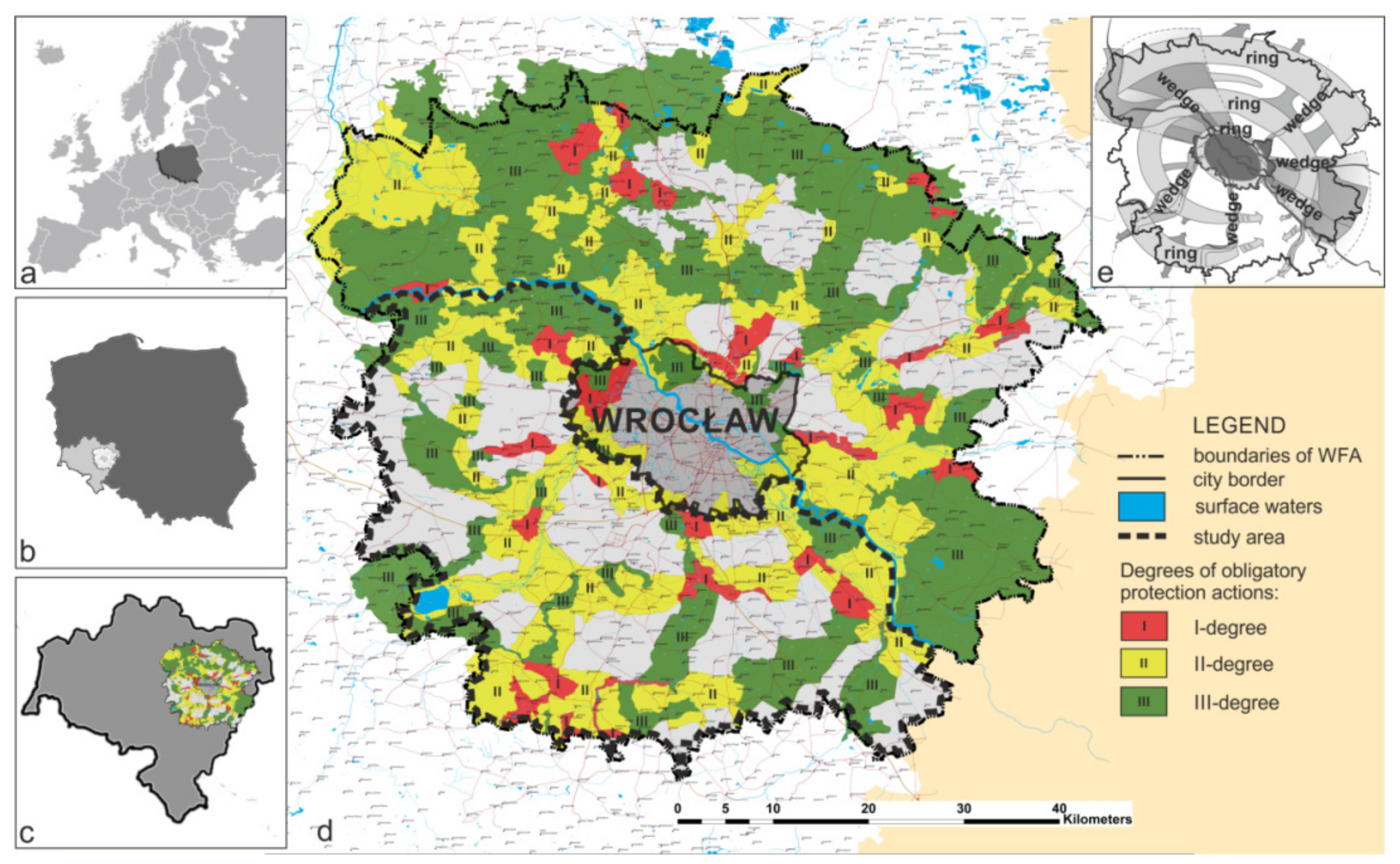
2.1. Study Area

The WFA has an area of 412,823 hectares, which represents 20.7% of the area of Lower Silesia. The vast majority of it (87.9%) is composed of rural areas. The WFA consists of 29 municipalities of urban, urban–rural and rural characters [53]. Wrocław itself is the fifth largest city in Poland (292.82 km2) and the fourth largest in terms of population (642,869 inhabitants) [54]. Functional city areas were introduced in Poland in 2011, along with the Concept of National Spatial Planning 2030 [55]. Their creation and appropriate planning is aimed at ensuring their proper and sustainable development. The functional area of Wrocław, similarly to the other functional areas of large Polish and European cities, is subject to increased investment pressure, manifesting itself mainly in the industry, housing and technical infrastructure sectors. Rapid urbanization causes fragmentation of open areas through housing development and jeopardizes the functioning of ecosystems [56]. By the end of 2018, the Wrocław Functional Area was inhabited by 924.9 thousand people; i.e., 25.2 thousand more than in 2014. The highest increase in population was observed in the municipalities directly adjacent to the borders of Wrocław [57]. Uncontrolled development of building investments is facilitated by inappropriate municipal spatial policies and the allocation of very large areas for housing development, not resulting from demographic or economic analyses [58]. An additional problem in Poland is that by 2018, the area of the country encompassed by development plans accounted for only 30% of its territory [59].

2.2. The Green Infrastructure System Project in the Wrocław Functional Area (GI WFA)

One of the first diagnostic and design studies undertaken for the WFA, to support multi-scale planning in the area, was the Green Infrastructure System (GI WFA) project. It became an integral part of the WFA Functional Cohesion Study; a larger study on the development and functioning of the WFA [60], which was then incorporated into preparations for the Spatial Development Plan (SDP) for the Lower Silesian Region, which was subsequently endorsed in June 2020.
The Institute for Spatial Development’s (IRT; a unit focused on regional planning) plan to prepare an SDP for the WFA, entitled “The optimal layout design for green infrastructure within the borders of the Wrocław Functional Area”, resulted from the need to construct the SDP in such a way as to preserve the largest possible number of natural and seminatural areas in the WFA and, if necessary, to indicate where such areas should be created or recreated, in order to preserve and strengthen the GI in the region. The SDP was to be a guideline for plans at the lowest level of local law (LSDP), identifying places where the development of buildings of various functions might possible, as well as where it would be absolutely unacceptable. However, the pressure on the local authorities to create large built-up areas was evident in the SUiKZP (intermediate plans between SDP and LSDP), where the built-up areas planned would create an uninterrupted line of development around the city and along its exit roads. As a result of an analysis of the existing natural and semi-natural areas, as well as a number of analytical studies for the WFA concerning the natural, cultural, tourism, transport, demographic and other potentials, a GI plan has been proposed that, in addition to the natural and semi-natural areas, also includes built-up areas (Figure 1e). Accordingly, the proposed system is called a system of GI rather than a network of GI. The system consists of three rings and five wedges, which have been defined in terms of the functions they will perform in the future. The wedges are based mainly on the River Oder and its 5 tributaries. At this stage, the external rings have not been closed, due to the absence of strong GI elements in the southern part of the system [61].
The project subsequently needed further development. In 2016, work on it continued with the aim of defining key locations in the system. These were places of both high natural potential and those in which a change of development, resulting from construction or the reduction of natural or semi natural areas, would diminish or ruin structural connectivity of the GI in the proposed system.
It was therefore proposed to divide the system into landscape-functional units (LaFU) with different landscape and natural characteristics and varying functions. These units would include not only open spaces but also the built-up areas in villages [62]. This would distinguish the planned GI system from systems where only open areas are included, such as Maryland [63], Zhengzhou-Kaifeng metropolitan area [64] and Montreal metropolitan area [65]. The division of the system into LaFUs would allow management from the level of both the entire WFA and the individual municipality. LaFUs are helpful in analyzing the strengths and weaknesses of an entire system, and, as such, they were assessed according to three criteria: firstly, the need to maintain the continuity of the various elements of the system (rings and wedges); secondly, the need to designate them as nodes of the system; and thirdly, risk resulting from the current municipal plans (SUiKZP) allowing for the development of buildings in economic activity zones. At the same time, public consultations were held with the authorities and residents, during which, among other things, LaFUs were established to close two rings in the missing locations in the south of the WFA (Figure 1d).
Finally, LaFUs were assigned 3 degrees of obligatoriness, so as to facilitate protective and strengthening measures or actions aimed at reducing the risk of degradation. Units with the first (highest) degree of obligatoriness for taking protective measures and mitigating or reducing risk are subject to close monitoring. An essential element of these units is the above-mentioned CoV, which is the basis of the present research project and its efforts at answering the research questions posed within this article. The analyses focused on the southern part of the system, with the Oder River line dividing the entire area into two parts, as well as being part of the border of the area under investigation (Figure 1d). This particular demarcation was selected in order to focus on the most problematic parts of the system (initial lack of ring connectivity and large number of LaFUs with I and II degree of obligatoriness).

2.3. Method

Research was based on analyses of historical and contemporary cartographic materials and historical iconographic materials, as well as contemporary photographs, including images from Google Street View (GSV). The analyses were also supported with data collected during field trips.
The analyses were conducted in two stages: a preliminary/general study (stage I) and a detailed study (stage II) (Figure 2).

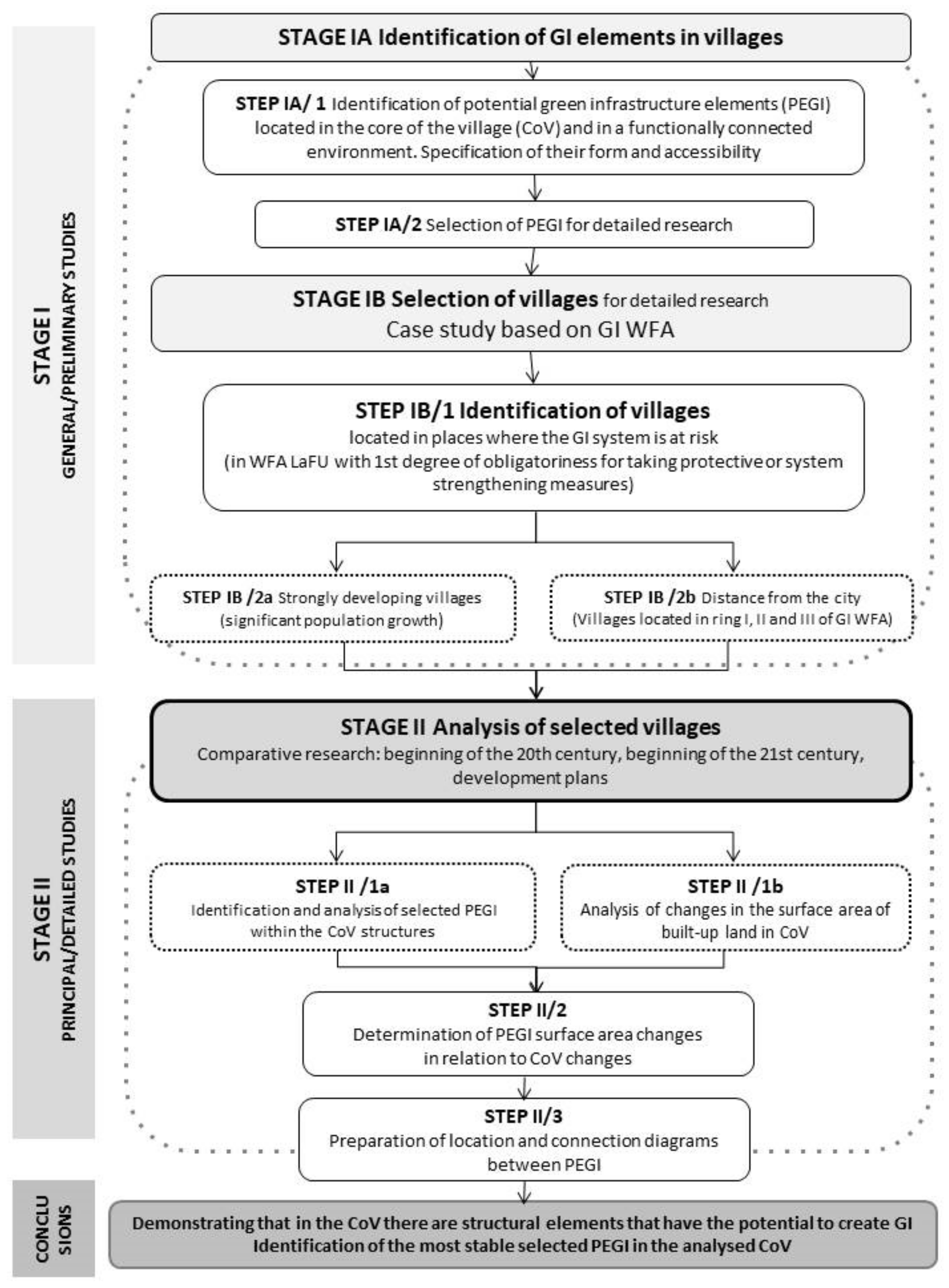
2.3.1. STAGE I Preliminary/General Study: STAGE IA Identification of GI Elements in the Villages

The first stage of research was divided into two parts: firstly (IA), identification of potential green infrastructure elements (PeGI), and secondly (IB), selection of villages for the detailed and main part of the study. Stage IA consisted of the theoretical identification and classification of PeGIs located within village registry boundaries; i.e., in the CoV and the areas surrounding it and functionally related to it, such as agricultural areas and forests. A PeGI is understood to mean areas with natural or semi-natural features or areas that can become green if managed appropriately. The analyses at stage I were conducted in two steps. Firstly, (STEP I/1), PeGIs were identified and subsequently analyzed and classified in terms of their:
(a)
location with respect to the CoV; i.e., their location inside or outside the CoV,
(b)
form (linear or areal-type),
(c)
accessibility/ownership (unrestricted, limited, not accessible) [66]. The term possibility of entering indicates whether the area was a public space (with it being fully possible to enter), a semi-public or private space (with only a partial possibility of entering; e.g., school, sanatorium) or a private property without the possibility of entering.
The research at this stage was conducted on the basis of literature reviews and conclusions drawn from work conducted previously by the authors of this study. Due to the research being conducted on a local level—the scale of a village—the focus was on the PeGI typology relevant to this scale. To date, the most comprehensive review of GI typology, using a variety of criteria, can be found in the work of Bartesaghi Koc et al. [66]. In turn, Davies et al. [67] and Young et al. [68] have also proposed a list of GI elements (present in EU documents), as well as a detailed description of their characteristics at local, neighborhood and village scales, together with a link to ESs which they fulfill [69,70]. Given that the present research was conducted using data from the Polish Topographic Objects Database (BDOT10k), it was also necessary to analyze the names of objects in this database that could be classified as PeGI, as well as to refer to their classification in the Corine Land Cover. Finally, a PeGI typology was developed for the village structure (CoV), together with its functionally related environment (Table 1). For the purposes of the analysis, 12 types of PeGI were identified: natural and semi-natural areas not used for agriculture, agricultural areas, mining and post-mining areas, parks and squares, green areas accompanying public facilities, recreational and sports grounds, cemeteries, private gardens, green areas accompanying communication routes, other green areas, water reservoirs and wetlands.
The second part of this stage of the research (STEP I/2) involved selection of PeGI for further detailed research. It was decided that these would be areas that were:
(a)
Located inside the CoV of individual villages,
(b)
Owned by a municipality or religious community; i.e., unrestricted or only limited accessibility/ownership. These were either public (with full access) or semi-public and private areas with partial access, shared by the inhabitants of a given village or visitors, such as tourists. Such a criterion is important, because the current and future development of these areas depends to a large extent on proper municipal spatial policies. Parks and water reservoirs were exceptions, where neither the possibility of entering nor the form of ownership were taken into account. The selection of elements for detailed research did not take into consideration green areas located on private plots of land, nor plots with residential or industrial functions.
The following PeGI were selected for detailed analysis, according to the guidelines specified in the methodology (the numbering refers to the typology in Table 1):
  • (4) Parks and squares. Parks (4a,b)and squares (4c);
  • (5) Areas accompanying public facilities. Areas located near places of worship (temples) (5a) and schools/kindergartens (5b) and areas next to cultural facilities (e.g., community centers) (5d);
  • (6) Recreational and sports areas. Recreation areas (6a), sports fields (6b), and playgrounds (6c);
  • (7) Cemeteries. Operating cemeteries (7a) and non-operating/closed cemeteries (7b);
  • (9) Green areas accompanying communication routes (e.g., avenues, lanes of trees). Green areas accompanying the main thoroughfares in the villages (9a);
  • (11) Water surface area. Water reservoirs/ponds (11b,c) and watercourses (11d,f) with their immediate surroundings.

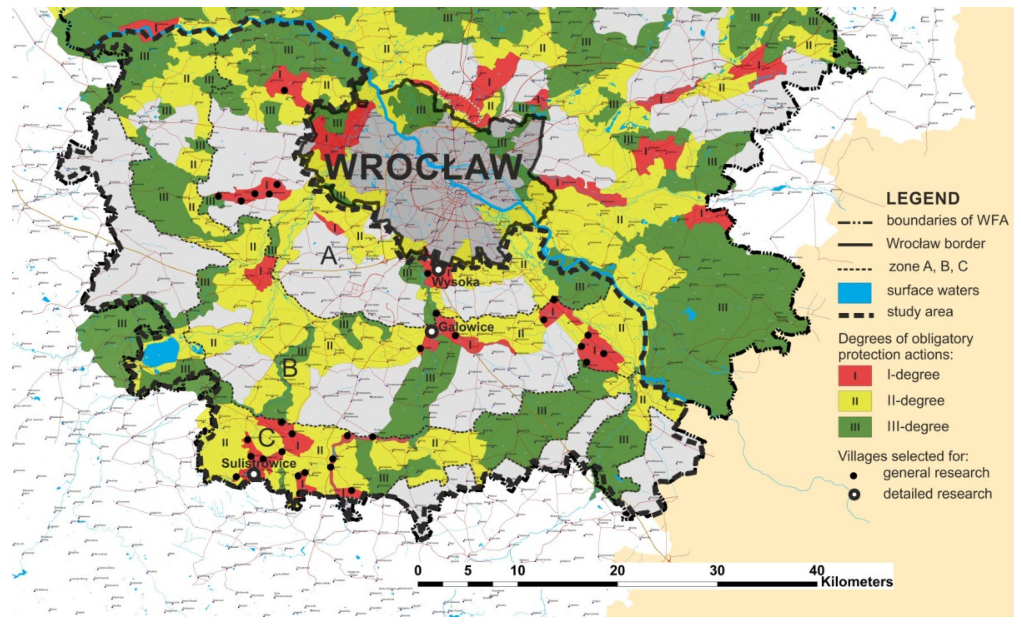
2.3.2. STAGE I Preliminary/General Study, STAGE IB Selection of Villages

The objective of the second part of the general/preliminary stage I (STAGE IB) was to select representative villages for research regarding the selected PeGI. As the present work was intended to help find possible ways to strengthen connectivity between GI elements in the WFA GI System, where this was difficult, it was assumed that research at this stage would be carried out in villages located in areas where the functioning of the GI system was considered to be at risk. Therefore, in the first stage of the research, the authors singled out all the villages located in the LaFUs of the southern part of the GI WFA system, which had the first (highest) degree of obligatoriness regarding implementation of protective or strengthening measures and actions aimed at reducing threats to the functioning of the GI system [62].
In the analyzed, southern part of the GI WFA system, there were 13 LaFUs, with the highest (first) degree of obligatory protective measures. There were 34 villages within these units (Figure 3).
Three zones of influence of the city of Wrocław on the GI system were defined, according to the distance from its borders. These were: Zone A—from the border of Wrocław to the inner border of ring two; Zone B—from the inner border of ring two to the inner border of ring three; Zone C—from the inner border of ring three to the outer border of the GI system (Figure 4). Defining these zones was necessary in order to determine the location of the villages analyzed in relation to Wrocław and to select the ones that represented each of the zones. In Zone A, there were eight villages located within four endangered LaFUs; in Zone B, there were 10 locations in 5 endangered LaFUs, while in Zone C, there were 16 villages in 4 endangered LaFUs. The majority of the villages analyzed had a historic palace or manor/folwark (76%), more than half of them had a historic park (56%) or a historic cemetery (59%), and more than one third of the villages had a historic church (38%). All of these buildings remain under legal protection, and all of them were analyzed in terms of the number of inhabitants in 1988 and 2011.
The selected period reflects a time of intensive suburbanization in Wrocław, caused by the political transformations occurring in Poland at the time, with 2011 being the last year from which data at this level of detail exist [71]. The villages were also examined in terms of their cultural heritage, with information compiled concerning palace complexes, manors and folwarks (a type of large production manor farm owned by a landlord), parks, churches and cemeteries that were located on their grounds. This information was collected from maps and field inventories (regarding the present), with information related to the beginning of the 20th century verified by the Monuments Register of the Lower Silesian Province [72]. In nine villages, there was a noticeable decrease of over 10% in the population between 1988 and 2011. The biggest decline, almost 70%, was observed in the village of Biskupice. Stagnation of village development was observed in nine villages (from −10% to +10% of the population growth). The remaining 16 locations had population growths of over 10%, of which 9 exceeded 30%. Two villages—Stanowice and Marcinkowice—doubled their number of inhabitants, while in the village of Wysoka, an increase in the number of residents by over fourfold was recorded (+433.33%) (Table 2).
Due to the fact that the comparative analyses contained in the following part of the detailed research section are concerned with the early 20th century, the 1912 population figures are also included in Table 2.
It was decided that further detailed research (STAGE IB/2a) would include villages from the group with the highest population growth (above 30%) in the period 1988–2011. This percentage covered about one quarter of all the villages under analysis. The initial number of inhabitants in 1912 did not affect the selection of investigation sites.
The other criteria that were used for the selection of villages for detailed research were, firstly, that it was mandatory for the villages to be located in each of the three zones A, B and C (Figure 3), and secondly, that the villages should have binding planning documents—in this case, local spatial development plans (LSDPs), which are the principal acts of local law in the Polish planning system, on the basis of which all investments are carried out (STEP I B/2b). These criteria were necessary in order to be able to analyze the villages’ planned future development.
On the basis of the above-mentioned criteria, three villages located in three different rings of the system were selected from the group of nine villages, where the increase in the number of inhabitants between 1988 and 2011 was higher than 30%. These were Wysoka (zone A, ring 1), Galowice (zone B, ring 2) and Sulistrowice (zone C, ring 3) (Table 2, Figure 4). The selection was also dictated by the specific characteristics of each village. Wysoka, for instance, borders directly with Wrocław; Sulistrowice, which is strongly urbanized, is located in the vicinity of the Ślężański Landscape Park and is thus attractive to both its inhabitants and the people of Wrocław. As for Galowice, it is located at the nodal part of the GI system, at the intersection of ring two, with a wedge resting on the Ślęza River.

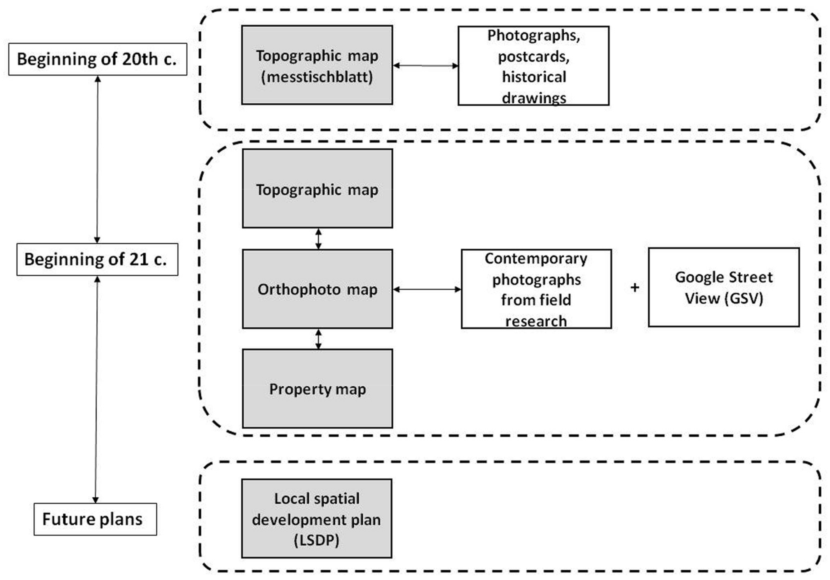
2.3.3. STAGE II Principal/Detailed Study: Analysis of Selected Villages

The preliminary studies (STAGE I) were designed to lay the foundation for the main research investigations (STAGE II), aimed at answering the research questions posed and achieving the stated goals (outlined above). The research in Stage II consisted of identifying particular PeGIs within CoVs in the villages selected (STEP II/1a), determining the extent of changes in the built-up areas of particular villages (STEP II/1b), identifying the areas which currently belong to the local government or the State and, finally, presenting the planned changes in the areas of the selected PeGI in relation to changes in the areas designated for development, as well as to the entire CoV (STEP II/2).
A different approach to analysis was applied in the case of land strips along the main thoroughfares passing through the villages (i.e., linear structures) than in the case of areal structures. It involved mapping former and current alleys and row plantings along them and determining their potential lengths.
In all the villages, CoV coverage was analyzed over 3 time periods, based on information contained in maps and plans:
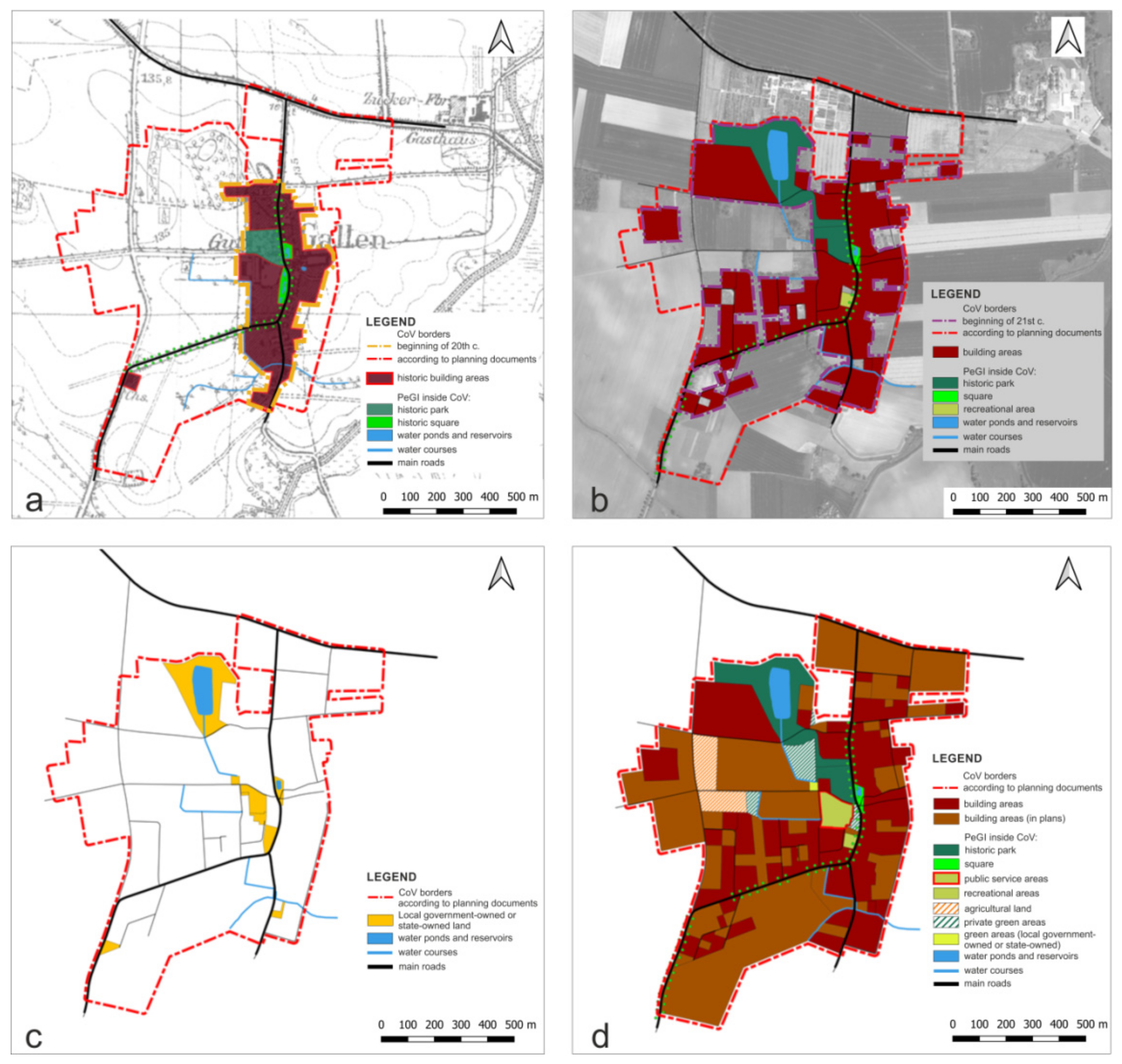
  • The past (the early 20th century), on the basis of historical topographic maps from the beginning of the 20th century drawn at a scale of 1:25,000 (messtischblatt), available online: http://mapy.amzp.pl/ (accessed on 30 December 2021);
  • The present (the early 21st century), based on contemporary topographic maps; orthophotomaps, available online: https://geoportal.dolnyslask.pl/(accessed on 30 December 2021);
  • The future adopting a period of between a dozen or so and several dozen years, based on planning studies—Local Spatial Development Plans (LSDPs) available at the Lower Silesian regional website https://geoportal.dolnyslask.pl/start/ (accessed on 30 December 2021), the national website https://www.geoportal.gov.pl/ (accessed on 30 December 2021) and the Spatial Information System of Wrocław County (WroSiP) https://www.wrosip.pl/ (accessed on 30 December 2021). Ownership structure was also examined to identify land owned by municipalities, counties or religious communities.
CoV boundaries were determined on the basis of plot boundaries (early 20th century) and land-registry boundaries (present and future). The road strip parcels were not separately demarcated, but counted as a whole in the CoV, while the areas of individual plots of land were related to the road axes.
The analysis of the village structure within the CoV from the early 20th century was made on the basis of historical maps and the available iconographic materials in the form of photographs and postcards. Due to the scale of the messtischblatt maps (1:25,000), the accuracy and precision of the results could only be approximated. The analysis of the contemporary CoV structure was based on cartographic materials and local site inspections obtained with Google Street View (GSV). The field studies consisted of an additional complementary analysis, which was based on the identification of visible PeGI inside the CoVs. Google Street View (GSV) was used only to support and complement the field research and to reduce the time-consuming work needed to verify certain doubts that arose during analysis and which would have necessitated another trip to the village. The research was also complemented by an additional study on land ownership, with all areas belonging to the local government or the state being identified. The future development plans for the villages were identified from the existing planning documents, i.e., LSDPs (Figure 4).
All the plots of land on the contemporary map were marked according to geodetic land divisions, with the inclusion of already existing buildings of any function. This analysis was based on the current development status, supplemented with all the areas that were designated in the LSDP for construction of structures of any function, including those marked as areas with permission for conditional development.
All of the built-up plots in the analysis of the three time periods were consolidated with the use of one color in the diagrams. However, the plots occupied by churches and schools, due to their inclusion in the analysis as PeGI, were distinguished independently in a different color. Schools had not been marked on early 20th century maps and thus their location had to be determined by interviews, field research and historical photos.
All the PeGI selected for investigation were marked on the three maps. Additionally, lists of individual PeGI and plots of land with buildings within the CoV were also compiled.
The last step of this stage (STEP IIB/3) was a summing-up of the analyses conducted in regard to PeGI in the selected villages. This consisted of developing patterns of location, layout and connections between the PeGI identified in the CoV. The goal here was twofold: to justify and verify the inadequate or inappropriate decisions included in the future plans (LSDPs), which disregarded or eliminated the strongest PeGI, and to highlight the possibility of shaping a coherent GI system within the CoV of individual villages.

3. Results

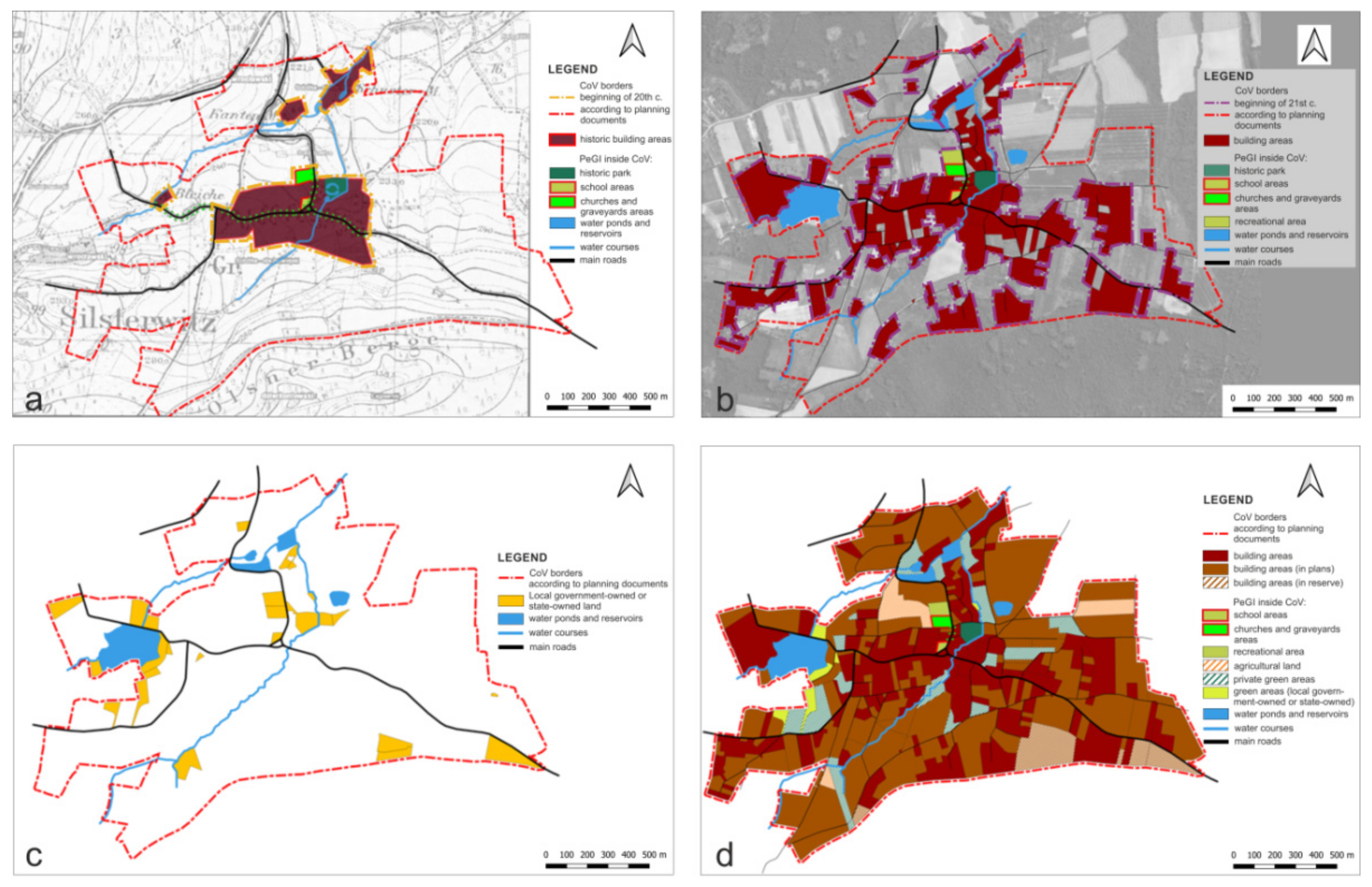
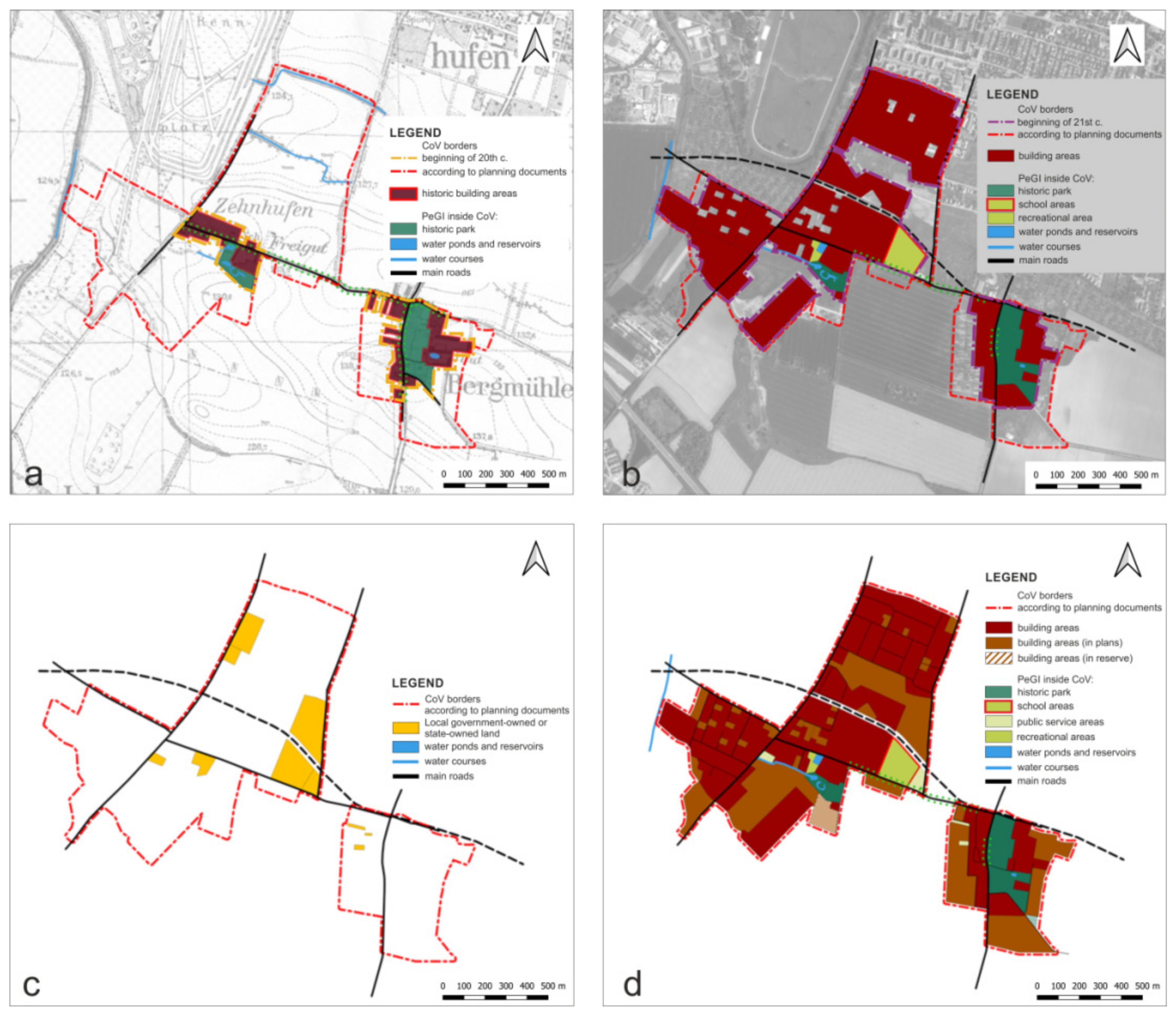
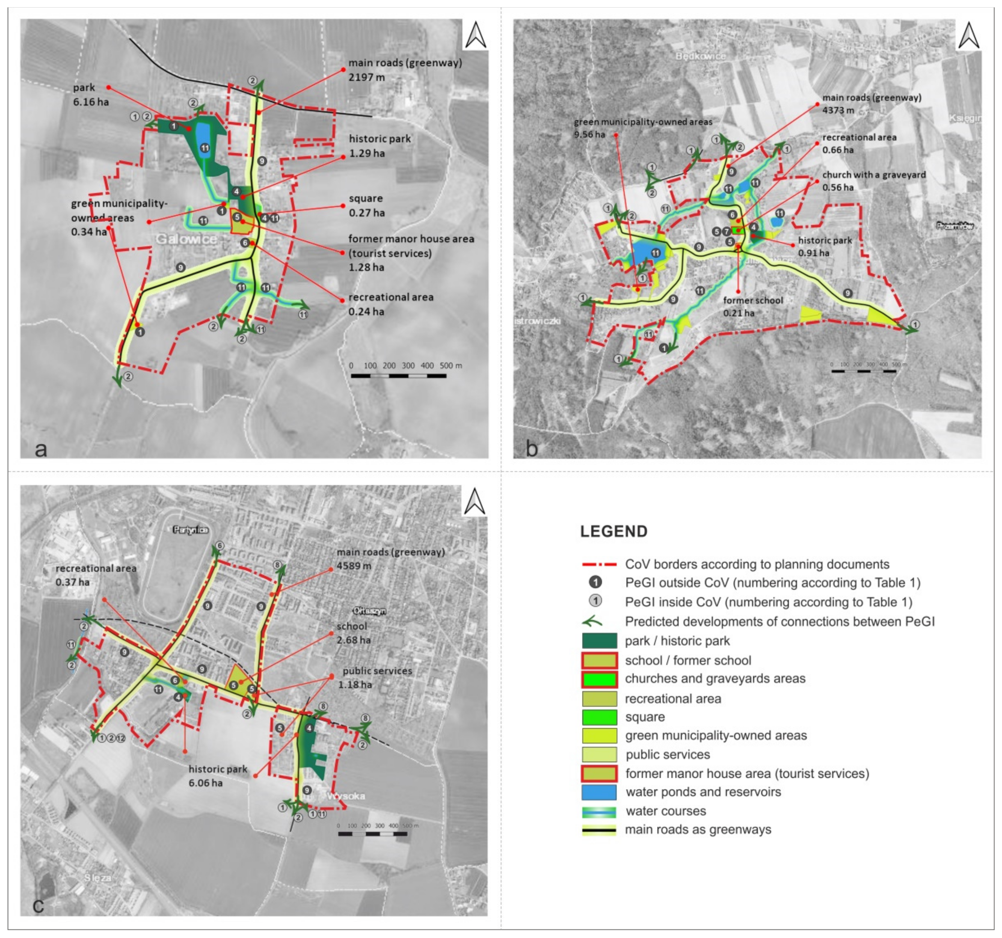
3.1. Past (Early 20th Century)

The first part of the study focused on historical analyses concerning the occurrence and location of particular PeGIs in the CoVs selected for analysis. The analysis of cartographic materials from the early 20th century made it possible to state that parks were one of the most important PeGI elements then, in terms of their size and presence on at least a single site in each CoV (defined for that period) (4a,b) (The numbering in round brackets throughout Chapter 3 follows the descriptions of elements selected for the PEGI study in Section 2.3.1.) These were once parts of former manor houses (Galowice, Sulistrowice, Wysoka, including two parks belonging to two manor houses in the Wysoka CoV). Additionally, PeGI were found in a group of single green areas associated with water reservoirs (11) (Galowice), a temple (5a), a cemetery (7) (Sulistrowice) and a school (5b) (Sulistrowice) (Figure 5a, Figure 6a and Figure 7a). The findings obtained from topographic maps regarding PeGI 4b, 5a and 7, were confirmed by materials collected from the archives of the Regional Conservator of Monuments in Wroclaw (WKZ) and in the register of monuments administered by the WKZ.
The locations of the areal PeGI were varied. Some of them, such as ponds with surroundings (11b) and a school (5b) in Sulistrowice, were centrally located in relation to the CoV of that time. However, most of the sites were located on the edges of contemporary CoVs. Examples include all of the parks (4a, b) in Sulistrowice, Galowice and Wysoka, as well as the church (5a) with a cemetery (7a) in Sulistrowice (Figure 5a, Figure 6a and Figure 7a).
Linear greenery systems (avenues and rows) (9a), which could have been links between areal PeGI, were not identifiable on the maps adopted for analysis and, as such, the graphical symbols of the elements of interest were not drawn within the CoV boundaries. However, in the case of areas outside the CoV boundaries, the avenues and rows along the access roads to villages (among other things) were marked. A survey of the available photographs and postcards from the early 20th century, which show the “interiors” of the analyzed CoVs, made it possible to establish that, at the beginning of the 20th century, there were linear plantings along the main communication routes, connected with those that reached the borders of the CoVs from the outside, in all the CoVs analyzed. This fact was confirmed by the continued presence of single, approximately 100-year-old trees, located along the main roads in Galowice, Sulistrowice and Wysoka. It can thus be concluded that there were linear PeGI (avenues and rows) connecting PeGI of an areal character, at the beginning of the 20th century, in the CoVs analyzed.

3.2. Present (Early 21st Century)

The subsequent part of the research was concerned with the contemporary PeGI picture, within the boundaries of the current CoVs. According to the research methods adopted, it was found that PeGIs of an areal character are still represented by parks and squares (4a, b and 4c) (Galowice, Sulistrowice, Wysoka), premises accompanying worship facilities (5a) (Sulistrowice) and a school (5b), Sulistrowice and a cemetery (7a) (Sulistrowice). Additionally, new PeGIs have appeared, including areas accompanying educational facilities (5b) (a school and a kindergarten in Wysoka) and sport and recreation areas (6b and 6c), including sports fields and playgrounds (6b and 6c) (Galowice, Sulistrowice, Wysoka) (Figure 5b, Figure 6b and Figure 7b).
The spatial distribution of PeGI in the CoVs was found to be highly variable. Most of the locations (including parks, the area surrounding the church with a cemetery, the area near the school and the historical square (4a, 4b, 5a, 7, 5b, 4c) have been historically conditioned. The findings show that those that were within the early 20th century CoV boundaries have remained in contact with early 21st-century CoV boundaries. These were parks (4a) and the church (5a) with a cemetery (7) in Sulistrowice. Sometimes PeGIs were found to form compact, adjacent areas or to be closely connected with each other, both functionally and in terms of road access. One example is the “green village center” in Galowice consisting of a park (4a), a square (4c), a pond (11b) and a recreational area (6a) (Figure 5b). A similar configuration exists in the center of Sulistrowice, consisting of church surroundings (5a) with a cemetery (7), a manor park (4a) and a green area next to a school (5b) (Figure 6b). The new PeGIs located on the edge of the CoV were found to have mainly recreational and sports functions (6). These include the sport and recreation grounds accompanying a water reservoir, built in the 1970s (11) in Sulistrowice. The area is owned by the municipality and is jointly used by both inhabitants and tourists (Figure 6b). There are some wastelands, owned by the municipality, on the outer boundary of today’s CoV. Numerous scattered plots of this type are located in Sulistrowice, with one also in Galowice (Figure 5c, Figure 6c and Figure 7c). The spatial layout of the PeGI within the contemporary boundaries of the CoV of Wysoka, conditioned by historical spatial development, has been enriched by an extensive school area (5b), located at the border of one of the two CoV areas that constitute the village of Wysoka (Figure 7b).
Linear PeGI patterns, i.e., green areas accompanying the main thoroughfares from group (9a) in the present CoV, are now practically absent. A fragment of a historical avenue was found in Galowice, with only single trees in the other villages, There is an absence of any deliberately introduced linear links (green corridors) between the existing PeGI areas.

3.3. Future—Village Development Plans

Areal and linear PeGI development in the CoVs studied was analyzed on the basis of existing LSDPs, according to which the planned boundaries of the CoVs were also determined. Land ownership structure in the villages analyzed was examined in order to identify which plots, owned by the municipality, county or religious communities, (Figure 5c, Figure 6c and Figure 7c), might be possible locations for PeGI on maps showing future development plans (Figure 5d, Figure 6d and Figure 7d). As a result, we identified PeGIs whose location resulted from the continuation of the historical (early 20th century) use of CoV land. These were mainly parks (4a) (Galowice, Wysoka), squares (4c) (Galowice, Sulistrowice) and school and church grounds (5b and 5a) in Sulistrowice. New PeGIs have also appeared in the present CoV. These are sport and recreation grounds (6) (Galowice, Sulistrowice, Wysoka) and areas of educational and public services (5b) (Galowice, Sulistrowice, Wysoka) (Figure 5d, Figure 6d and Figure 7d).
It was found that the majority of municipality-owned plots in all the CoVs analyzed have been designated for building investments, according to future plans. Only a few plots, mainly with a recreational function (6a), have been planned as PeGI.
It was also found that the historically shaped “green village center” in Galowice is to be enhanced through the addition of the area of the former manor farm, where tourist services (6a) and green areas (4) are planned (Figure 5d). However, the two small areas belonging to the municipality located in the south of the village have not yet been designated for greening (Figure 5d).
Increasing the number of PeGI areas was found to be more problematic in the Wysoka CoV, which has expanded significantly since the beginning of the 21st century. The boundaries of the current CoV are almost identical to the administrative boundaries of the village and have been almost entirely filled with single-family and multi-family housing complexes. The only PeGIs with the character of a public space are based on two historical premises, additionally extended by a new school (5b) and a small recreational area (6a). These belong to the municipality (Figure 7c) and are not intended for the creation of new green spaces (Figure 7d).
Even more radical solutions have been provided by LSDPs for Sulistrowice, where a multi-family housing complex has been planned on the area of a historical park (4a). Moreover, large areas belonging to the municipality, currently without buildings (Figure 6c), but which could potentially be PeGI, are to be built up in the future (Figure 6d). The LSDP records for the villages analyzed do not provide for linear PeGIs (9a). The exception is Sulistrowice, where planting is to be undertaken along a fragment of the exit road in the eastern part of the village.

3.4. Comparative Analysis

The analysis of particular PeGI types, over different time periods, shows that manor parks (4a), church areas (5a) and green areas accompanying schools (5b) are the most durable. Durability is understood as invariability over time, the maintenance of identical or similar utility function, and surface area. In the CoVs analyzed, the above-mentioned PeGI have maintained these criteria since the beginning of the period analyzed (the early 20th century) to the present. A comparison of the surface areas of particular types of PeGIs in all the villages examined, over the three time periods of interest (Table 3, Table 4 and Table 5), shows that their surface areas are slowly increasing in both Wysoka and Galowice but that they are to be liquidated in Sulistrowice.
The present research has shown that, over a period of about 100 years, the built-up areas in Galowice and Sulistrowice have almost tripled in size. Concurrently, they have grown by almost six times in Wysoka, which borders with the city of Wrocław,. All of the villages plan further expansion. The local development plans for Galowice and Sulistrowice foresee the possibility of tripling the size of the built-up areas in relation to the current situation (Table 6). In Wysoka, a 60% increase has been estimated, a result of the fact that only this much open area remains within the administrative borders of the village.
Overall analysis of the areas selected for the PeGI studies, for all three periods (Table 7), showed that their sizes are not increasing proportionally to the increase in built-up areas in the villages under study. The percentage share of PeGI in the CoVs in Galowice and Wysoka has decreased, from about 40% at the beginning of the 20th century to about 12% by the beginning of the 21st century, although according to development plans, the figure is closer to 10%. In Sulistrowice, at the beginning of the 20th century, this share was a mere 7%, while at the moment it is around 15%. Future plans predict a decrease to only around 2%, which is due to a significant, planned increase in the number of buildings with a residential function.
The areas along the main roads in the CoVs are PeGIs of a linear type, which can be developed as greenways connecting PeGIs of an areal type, inside the CoV. The green areas along the roads can also be used as links to external, natural or semi-natural GI elements.
As far as linear PeGI—alleys and greenery rows—are concerned, their analysis showed a significant disappearance of historic forms and an absence of new ones in the planning documents. Historical avenues were found inside the CoVs of all the villages analyzed, but only one of them (Galowice) has been maintained in its residual state, with only single trees preserved in the other two CoVs. However, no current avenue or line tree planting initiatives were found in any of the villages analyzed.
Figure 8 shows a schematic layout of the areal type PeGI identified in the three sites under analysis. The diagram indicates main roads, which have the potential to be developed in the form of greenways, as well as watercourses, which constitute linear links between the PeGI areas identified. The proposal to use the main roads for this purpose is based on the fact that only in this case would the width of the road lane (shoulders) allow for safe development (in regard to passage) of their biologically active elements, which could constitute linear PeGIs.
The vision presented above assumes the possibility of creating an ecological system that would link elements in the form of patches and corridors. The potential length of greenways planned in this way would be 2197 m in Galowice, 4373 m in Sulistrowice and 4589 m in Wysoka. This type of development would be conducive to increasing the spatial and ecological connectivity of the GI system on a village scale.
In each of the investigated villages investigated, the potential for structural connectivity between the PeGIs located inside the CoV, with the PeGIs located outside its boundaries, was also subject to examination (according to Table 1). This was essential because of the structural connectivity of the GI; the PeGIs located outside the CoV boundaries form a network of GI in individual LaFUs, which make up the designed WFA GI system. The study revealed that PeGIs located inside villages were most often connected to PeGIs from group two (agricultural land (15)) and from group one (natural and semi-natural areas not used for agriculture (13)). Connections with PeGI from groups 11 and 12 were found in seven locations; i.e., water surface areas and wetlands. Single connections were found to exist with PeGIs from group eight (private gardens and allotment gardens) and from group six (recreational areas) (Figure 8).
The schemes presented show the possibility of using public and semi-public green areas, located inside CoVs, as structural links within the elements of the regional GI network. Given that there are 34 villages in all of the LaFUs threatened by building investment intensification, in the area encompassed by this study, a GI WFA system with proper planning and management of public and semi-public areas would have a positive impact on strengthening the GI network.

4. Discussion

The research carried out in the present work aimed at determining the occurrence and transformational tendencies of GI elements, named and classified as PeGIs, in CoVs located in the metropolitan area of the city of Wroclaw. It also aimed at specifying whether it would be possible to increase structural connectivity of GIs in the system. Ultimately, it was important to establish the extent to which the results could applied universally and applied to other peri-urban and metropolitan areas.

4.1. PeGI Classification and CoV Selection

GI research has always been characterized by a holistic approach to landscape conservation, planning and management, at different scales and in varying contexts [8]. Most researchers define it in terms of a multifunctional network of natural and semi-natural elements and relate it to ES [25,27,67,73,74,75]. The multiplicity of approaches and applications in GI research presents very diverse ways of classifying its components and thus, as pointed out by Bartesaghi Koc, Osmond and Peters [66], creating a universal typology would be rather impractical. This article uses a functional-configuration classification of PeGIs, which are understood as open spaces. The parameters of accessibility, ownership and spatial configuration were thus taken into account. Significantly, PeGI classification covers not only places with an abundance of natural features [12,26,27,31,63] but also land that does not have such features today but that could potentially have them in the future, with the appropriate human intervention. This is what is understood as the potential of a site to become a GI. An example might be the area of land around a public building or the surface of a square, which may presently be largely concrete and devoid of greenery. CoV analyses also take this type of land into account, as potential GIs with all of their associated attributes. The comparison of the conducted PeGI classification with compilations and analyses of GI classifications [27,66,67,68] shows that the classification proposal presented here can be a valuable addition when conducting GI studies in peri-urban areas.
One of the criteria used in the present work for selecting PeGIs for detailed research was accessibility and ownership, understood as the real possibility for users to enter and use the area. However, accessibility of the PeGI from the perspective of the residents of the nearby city (Wroclaw), which is an important issue in studies of peri-urban areas and green spaces, was not taken into consideration. Similar studies take into account other accessibility criteria, such as distance and time, transport and spatial links [76,77,78], agglomeration type, urban sprawl [79] and the preferences of the residents themselves [80]. The reason for this omission was that in the approach utilized here, the focus was not on meeting the needs of central city residents but on searching for potential connections within the existing structures of the GI WFA system.
In the CoV analysis of CoVs and the selection of PeGIs for the detailed study, private land—primarily domestic gardens and areas surrounding a property, including the front garden—was excluded. Only public and semi-public land was selected because, through appropriate spatial policy (plans and designs and actual maintenance), the municipality has the greatest and most direct influence on shaping the development of these sites. The greening of private CoV land, i.e., rural front gardens, orchards, meadows located between rural buildings, is a very important consideration in the context of GI connectivity and biodiversity [81] but so extensive as to require a separate study.

4.2. Identification and Analysis of PeGI Inside CoVs

Another criteria used in selecting CoVs in the present investigation was that of their having valid plans for the future. This was important for f analyzing the future development of CoV areas and in assessing the sustainability of the historical GI elements identified. Such plans are particularly important from the point of view of shaping the landscape and space around the city of Wrocław. They are the only compulsory documents that allow for legal enforcement of the spatial policies conducted in a given area, obliging investors to comply with the provisions contained therein. The specificity of spatial planning in Poland has resulted in the fact that, by 2012, only 54% of the WFA area was encompassed by local spatial development plans (LSDPs). In the remaining areas, investments have been possible on the basis of the so-called Land Development Decision (LDD), issued by a single-person executive body of the municipality, i.e., by the mayor, city president or village head [82,83]. As such, it is possible to include GI plans in almost half of the WFA area’s LSDPs, a proportion often indicated as necessary for urban areas [84]. Furthermore, the selection of CoVs within LSDPs made it possible to determine whether, in CoVs with intense development, the growth of built-up areas would, in the future, be accompanied by an increase in public and semi-public green spaces. In this respect, the answer is definitely negative, which reveals a failure to recognize the role of GI in current planning. The result of the present analysis is similar to a study conducted in regard to coastal areas in Texas [85]. GI as a support in planning has also been pointed out by Laforteza et al. [74].
In addition, the present research has shown that 100 years ago, the percentage of PeGI in the CoVs was four times higher, in all the localities analyzed, than in current development plans. However, the inclusion of agricultural-land-type PeGIs, which have traditionally lain within the administrative boundaries of villages (although this has been changing over time) might blur this conclusion. Nonetheless, PeGIs in GI analyses can serve as indicators showing the need to change development plans for the purpose of maintaining resilient peri-urban areas The present research has also addressed the issue of durability of PeGIs. In the historical rural landscapes of the sites analyzed, areas such as parks, squares and alleys have been important elements of the cultural landscape. Since the late 19th century, they have been protected in accordance with the ideas of the Heimatschutzt (Homeland protection) movement [86,87]. The analyses conducted in this study have confirmed the findings of previous studies [88,89] that the most durable PeGIs within the adopted time period of 100 years have been manor parks. These had already been shaped by the 19th century, through a combination of practical and aesthetic concerns, as venues for owners’ time and leisure, with some of them open to village inhabitants. Moreover, roads planted with trees connected the parks and forests, as well as the meadows and fields, included in estates and constituted the main routes between villages [90]. By the beginning of the 20th century, alleys were present in every CoV covered by the analysis. However, this type of PeGI is not as permanent as the parks mentioned above. Today, these old avenues have disappeared or have been preserved only in residual form. According to present day plans, parks will be located in the interiors of the CoVs, which means that, if properly managed, they will act as stepping-stone reserves. However, the growth in the popularity of parks—now often poorly managed—may undermine their current ecosystems in the future. This is well-known, and much research is addressing the conflict between the social function of green spaces and their ecological function [25,91,92].
Many limitations were encountered in this study on the durability of historical PeGI. The available materials adopted were not always sufficient for proper analysis, and historical maps from the beginning of the 20th century (messtischblatt) did not indicate all of the PeGI elements inside the CoVs. While historical maps are a rich source of data and are therefore often used as sources of information (e.g., [93]), in this case they did not provide much detailed insight concerning PeGIs from the group of green areas accompanying communication routes (e.g., avenues, lanes of trees), nor the PeGIs in areas accompanying public facilities (e.g., churches and schools). For these reasons, postcards and photos from the early 20th century were used as sources of supplementary material for proper PeGI identification. Additionally, field research was done to confirm the presence of avenue tree remains in the area. Confirmation of the fact that rural roads performed the function of greenways in the past was crucial, as it provided potential opportunities for reinstating very important PeGIs—not only in open spaces but also inside CoVs. Similarly, the use of Google StreetView (GSV) for PeGI analysis of present conditions supported the use of cartographic material and site inspections. However, while GSV is a convenient tool, the question of whether it would allow analysis to proceed without site visits is a contentious one, especially in the case of large area analysis. Nonetheless, the usefulness of GSV in greenery research on a local scale has also been confirmed through the studies of other authors [94,95,96]. The investigations carried out in this study have shown that the development plans of new and already existing CoV PeGI are surrounded by built-up areas. The historical PeGIs analyzed were put into place in the early 20th century (100 years ago) at the edge of the CoV boundary, whereby they were connected to external open areas, such as natural and semi-natural areas or agricultural land. As has been pointed out in the literature [91], structural connectivity is linked to functional connectivity, and although ecological aspects were not the focus of our study, we assume that areal PeGIs will form stepping stones in CoVs as—inter alia—tree planted areas. The connections of internal PeGI areas should be reinforced by greenways. Tree-lined streets, which are recognized as important multifunctional green infrastructure corridors in urbanized areas [97,98], can also be strengthening elements of the GI network of a CoV. They can be expanded to include new climate-change-relevant elements with regard to, for example, sustainable rainwater management [99]. CoV green streets are also important because peri-urban villages are changing their character and are beginning to resemble the city in terms of structure, layout and type of development [46]. Different types of conversions, such as densification of built-up areas, the retrofitting of old houses or changing garden structures (e.g., fewer old trees), results in reduced species richness, as birds (for example) can no longer nest in trees or houses [100,101]. Street tree planting might reduce such changes, as has also been suggested by other authors (e.g., [102]). Unfortunately, current plans fail to include clearly marked green corridors along roads, in reference to historical avenues or watercourses.
Finally, the present research has pointed out the potential for structural interconnections of PeGI located inside CoVs with those PeGI located outside. This is relevant in the context of GI network connectivity, throughout the planned GI WFA system. PeGI in CoVs connect primarily with semi-natural areas and farmlands. This is due to the fact that all the CoVs selected in the study lie within Type K of the GI WFA LaFU. As such, they are units with predominantly agricultural areas, according to the typology of units adopted [62]. Agricultural land accounts for a significant part of the planned GI WFA system, thus preserving and strengthening the connections between them. As shown above, connections between farmlands and the greenery of semi-public and public areas inside CoVs can be strengthened concurrently with the reinforcement of GI system connectivity. As such, the greenery of semi-public and public areas of CoVs is also very important. The role of farmlands in the development of GI regional networks has also been highlighted by other researchers [26,103]. However, neither of these works analyzed the structural connectivity resulting from the location of CoVs among agricultural fields, including structural connectivity between the green public and semi-public areas inside the CoV and the agricultural areas outside its boundary.

5. Conclusions

The research presented in this article fills a gap in studies on rural green spaces and their importance in increasing regional GI networks. The main conclusions are summarized below:
  • The proposed approach to GI research is of a specific and original character, as it relates to the boundaries of CoVs and to the PeGI systems. The potential of PeGIs results not only from their current natural assets but also from the possibility of changing their management in the future. Consequently, through appropriate planning, design and management, PeGI are able to become multifunctional elements of regional GI networks.
  • It would be valuable for future research on rural and peri-urban areas to adopt the definition of CoV presented in this paper, as well as its delimitations (including the way of defining its boundaries). The concept of a CoV is essential for future rural studies, as it will enable comparative analyses of other localities, not only in Poland but also in other countries. At the same time, it will prevent discrepancies that may arise from use of the more general and ambiguous term village.
  • The presented study focused on a selection of PeGIs comprising public and semi-public areas, their identification in relation to CoVs and an analysis of location and durability. Durability was defined as structural stability, measured in terms of PeGI presence throughout the past (early 20th century), present and future CoVs. The PeGIs of a public and semi-public character in the CoV included parks, squares, cemeteries, areas adjacent to public facilities and roadside greenery. The findings indicate that parks are among the most durable PeGI elements, i.e., still present in the CoV landscape today and included in future plans. In contrast, the least durable PeGI was found to be the greenery along roads. It was also found that at the beginning of the 20th century, in the CoVs analyzed, there were linear PeGIs (avenues and rows) connecting PeGIs of an areal character.
  • Unfortunately, it was found that current planning documents do not take the structure and connectivity of PeGI in the CoV into consideration Moreover, despite the growth of built-up areas, there are also no provisions in place for the proportional growth of PeGI, nor are there considerations regarding their potential connections to external PeGIs. The investigations revealed that, even the connections that do exist are separated by built-up areas and are being pushed away from CoV boundaries. This poses a particular threat to the GI network, particularly in peri-urban areas, which are constantly being exposed to strong pressure from new forms of development, including built-up empty spaces.
  • Ultimately, this study has demonstrated that it would be possible to create a network inside CoVs on the basis of existing PeGI, especially since these are often historic elements and structures, which in many places would facilitate not only the creation of new kinds of greenery but also the restoration of historic forms. To strengthen the structural connectivity of the GI network, it would be advisable to modify existing development plans and to undertake transformations in situ, through the implementation of appropriate projects and in cooperation with villagers and other stakeholders.
The results of this study provide important guidelines for spatial planning at the local municipality level in the context of preserving and strengthening the structural connectivity of GI networks. As such, the approach proposed can be used in other peri-urban areas worldwide.

Author Contributions

Conceptualization, I.N.-F., J.G., A.P. and J.R.; methodology, I.N.-F., J.G., A.P. and J.R.; software, J.G. and A.P.; validation, I.N.-F. and J.G.; formal analysis, A.P., J.R. and A.W.; investigation, I.N.-F., J.G., A.P., J.R. and A.W.; resources, J.G. and A.P.; writing—original draft preparation, I.N.-F. and J.R.; writing—review and editing, I.N.-F. and J.R.; visualization, I.N.-F., J.G., A.P. and J.R.; supervision, I.N.-F.; project administration, I.N.-F. All authors have read and agreed to the published version of the manuscript.

Funding

The APC is financed by Wroclaw University of Environmental and Life Sciences.

Institutional Review Board Statement

Not applicable.

Informed Consent Statement

Not applicable.

Data Availability Statement

Not applicable.

Conflicts of Interest

The authors declare no conflict of interest.

References

  1. Pauleit, S.; Ambrose, B.; Endersson, E.; Anton Buijs, A.; Haase, D.; Elands, B.; Hansen, R.; Kowarik, I.; Kronenburg, J.; Mattijssen, T.; et al. Advancing urban green infrastructure in Europe: Outcomes and reflections from the GREEN SURGE project. Urban For. Urban Green. 2019, 40, 4–16. [Google Scholar] [CrossRef]
  2. Seiwert, A.; Rößler, S. Understanding the term green infrastructure: Origins, rationales, semantic content and purposes as well as its relevance for application in spatial planning. Land Use Policy 2020, 97, 104785. [Google Scholar] [CrossRef]
  3. Chang, Q.; Li, X.; Huang, X.; Wu, J. A GIS-based Green Infrastructure Planning for Sustainable Urban Land Use and Spatial Development. Procedia Environ. Sci. 2012, 12, 491–498. [Google Scholar] [CrossRef] [Green Version]
  4. Demuzere, M.; Orru, K.; Heidrich, O.; Olazabal, E.; Geneletti, D.; Orru, H.; Bhave, A.G.; Mittal, N.; Feliu, E.; Faehnle, M. Mitigating and adapting to climate change: Multi-functional and multi-scale assessment of green urban infrastructure. J. Environ. Manag. 2014, 146, 107–115. [Google Scholar] [CrossRef]
  5. Gill, S.E.; Handley, J.F.; Ennos, A.R.; Pauleit, S. Adapting Cities for Climate Change: The Role of the Green Infrastructure. Built Environ. 2007, 33, 115–133. [Google Scholar] [CrossRef] [Green Version]
  6. Norton, B.A.; Coutts, A.M.; Livesley, S.J.; Harris, R.J.; Hunter, A.M.; Williams, N.S.G. Planning for cooler cities: A framework to prioritise green infrastructure to mitigate high temperatures in urban landscapes. Landsc. Urban Plan. 2015, 134, 127–138. [Google Scholar] [CrossRef]
  7. Sussams, L.; Sheate, W.; Eales, R. Green infrastructure as a climate change adaptation policy intervention: Muddying the waters or clearing a path to a more secure future? J. Environ. Manag. 2015, 147, 184–193. [Google Scholar] [CrossRef]
  8. Benedict, M.A.; McMahon, E.T. Green Infrastructure: Smart Conservation for the 21st Century. Renew. Resour. J. 2002, 20, 12–17. [Google Scholar]
  9. European Commission (EC). The European Biodiversity Strategy 2030: Bringing Nature Back into Our Lives; European Commission: Brussels, Belgium, 2020; Available online: https://eur-lex.europa.eu/legal-content/EN/TXT/?qid=1590574123338&uri=CELEX:52020DC0380 (accessed on 20 January 2022).
  10. European Commission. Directorate General for the Environment. Building a Green Infrastructure for Europe; Publications Office: Luxembourg, 2014; Available online: https://data.europa.eu/doi/10.2779/54125 (accessed on 20 January 2022).
  11. European Commission. Directorate-General for Environment, the European Green Deal; Publications Office: Brussels, Belgium, 2019; Available online: https://eur-lex.europa.eu/legal-content/EN/TXT/?qid=1576150542719&uri=COM%3A2019%3A640%3AFIN (accessed on 20 January 2022).
  12. Amati, M.; Taylor, L. From Green Belts to Green Infrastructure. Plan. Pr. Res. 2010, 25, 143–155. [Google Scholar] [CrossRef]
  13. Cieszewska, A. Green Belts. Zielone Pierścienie Wielkich Miast (Green Belts. Green Rings of Big Cities); SEDNO Wydawnictwo Akademickie: Warszawa, Poland, 2019. (In Polish) [Google Scholar]
  14. De Oliveira, F.L. Green Wedge Urbanism: History, Theory and Contemporary Practice; Bloomsbury Academic: New York, NY, USA, 2017. [Google Scholar]
  15. European Environmental Agency. Urban Sprawl in Europe. The Ignored Challenge; Technical Report No. 10/2006; Office for Official Publications of the European Communities: Luxembourg, 2006; Available online: https://www.eea.europa.eu/publications/eea_report_2006_10/eea_report_10_2006.pdf (accessed on 12 December 2021).
  16. Hennig, E.I.; Schwick, C.; Soukup, T.; Orlitová, E.; Kienast, F.; Jaeger, J.A. Multi-scale analysis of urban sprawl in Europe: Towards a European de-sprawling strategy. Land Use Policy 2015, 49, 483–498. [Google Scholar] [CrossRef] [Green Version]
  17. Robinson, D.T. Land-cover fragmentation and configuration of ownership parcels in an exurban landscape. Urban Ecosyst. 2012, 15, 53–69. [Google Scholar] [CrossRef]
  18. Bittner, C.; Sofer, M. Land use changes in the rural–urban fringe: An Israeli case study. Land Use Policy 2013, 33, 11–19. [Google Scholar] [CrossRef]
  19. Ravetz, J.; Fertner, C.; Nielsen, T.S. The Dynamics of Peri-Urbanization. In Peri-Urban Futures: Scenarios and Models for Land Use Change in Europe; Nilsson, K., Pauleit, S., Bell, S., Aalbers, C., Nielsen, T.S., Eds.; Springer: Berlin/Heidelberg, Germany, 2013; pp. 13–44. [Google Scholar]
  20. Kovács, Z.; Farkas, J.Z.; Egedy, T.; Kondor, A.C.; Szabó, B.; Lennert, J.; Baka, D.; Kohán, B. Urban sprawl and land conversion in post-socialist cities: The case of metropolitan Budapest. Cities 2019, 92, 71–81. [Google Scholar] [CrossRef]
  21. Spyra, M.; Inostroza, L.; Hamerla, A.; Bondaruk, J. Ecosystem services deficits in cross-boundary landscapes: Spatial mismatches between green and grey systems. Urban Ecosyst. 2018, 22, 37–47. [Google Scholar] [CrossRef]
  22. Tian, Y.; Zhou, D.; Jiang, G. Conflict or Coordination? Multiscale assessment of the spatio-temporal coupling relationship between urbanization and ecosystem services: The case of the Jingjinji Region, China. Ecol. Indic. 2020, 117, 106543. [Google Scholar] [CrossRef]
  23. Liu, J.; Daily, G.C.; Ehrlich, P.R.; Luck, G.W. Effects of household dynamics on resource consumption and biodiversity. Nature 2003, 421, 530–533. [Google Scholar] [CrossRef]
  24. Mckinney, M.L. Urbanization, Biodiversity, and ConservationThe impacts of urbanization on native species are poorly studied, but educating a highly urbanized human population about these impacts can greatly improve species conservation in all ecosystems. BioScience 2002, 52, 883–890. [Google Scholar] [CrossRef]
  25. Pauleit, S.; Liu, L.; Ahern, J.; Kazmierczak, A. Multifunctional green infrastructure planning to promote ecological services in the city. In Urban Ecology. Patterns, Processes and Applications, 2nd ed.; Niemelä, J., Breuste, J.H., Huntenspergen, G., McIntyre, N.E., Elmqvist, T., James, P., Eds.; Oxford University Press: Oxford, UK, 2011. [Google Scholar] [CrossRef]
  26. Rolf, W.; Pauleit, S.; Wiggering, H. A stakeholder approach, door opener for farmland and multifunctionality in urban green infrastructure. Urban For. Urban Green. 2019, 40, 73–83. [Google Scholar] [CrossRef]
  27. Wang, J.; Banzhaf, E. Towards a better understanding of Green Infrastructure: A critical review. Ecol. Indic. 2018, 85, 758–772. [Google Scholar] [CrossRef]
  28. Benedict, M.A.; McMahon, E.T. Green infrastructure. Linking Landscapes and Communities; Island Press: Washington, DC, USA, 2006. [Google Scholar]
  29. Hodgson, J.A.; Thomas, C.D.; Wintle, B.A.; Moilanen, A. Climate change, connectivity and conservation decision making: Back to basics. J. Appl. Ecol. 2009, 46, 964–969. [Google Scholar] [CrossRef]
  30. Krosby, M.; Tewksbury, J.; Haddad, N.M.; Hoekstra, J. Ecological Connectivity for a Changing Climate. Conserv. Biol. 2010, 24, 1686–1689. [Google Scholar] [CrossRef] [PubMed]
  31. Bierwagen, B.G. Connectivity in urbanizing landscapes: The importance of habitat configuration, urban area size, and dispersal. Urban Ecosyst. 2007, 10, 29–42. [Google Scholar] [CrossRef]
  32. Elmqvist, T.; Zipperer, W.C.; Güneralp, B. Urbanization, habitat loss and biodiversity decline: Solution pathways to break the cycle. In The Routledge Handbook of Urbanization and Global Environmental Change; Seto, K.C., Solecki, W.D., Griffith, C.A., Eds.; Taylor and Francis: London, UK, 2015; pp. 139–151. [Google Scholar]
  33. Zeller, K.; Lewison, R.; Fletcher, R.; Tulbure, M.; Jennings, M. Understanding the Importance of Dynamic Landscape Connectivity. Land 2020, 9, 303. [Google Scholar] [CrossRef]
  34. Fletcher, R.J.; Burrell, N.S.; Reichert, B.E.; Vasudev, D.; Austin, J.D. Divergent Perspectives on Landscape Connectivity Reveal Consistent Effects from Genes to Communities. Curr. Landsc. Ecol. Rep. 2016, 1, 67–79. [Google Scholar] [CrossRef] [Green Version]
  35. Aurambout, J.-P.; Barranco, R.; LaValle, C. Towards a Simpler Characterization of Urban Sprawl across Urban Areas in Europe. Land 2018, 7, 33. [Google Scholar] [CrossRef] [Green Version]
  36. Liu, Z.; Robinson, G.M. Residential development in the peri-urban fringe: The example of Adelaide, South Australia. Land Use Policy 2016, 57, 179–192. [Google Scholar] [CrossRef]
  37. Tanaś, J.; Trojanek, M. Changes in land use structure in suburban zones in Poland after the 90. J. Int. Stud. 2014, 7, 81–89. [Google Scholar] [CrossRef] [PubMed]
  38. Grochowski, M.; Korcelli, P.; Kozubek, E.; Sławiński, T.; Werner, P. Warsaw: Spatial Growth with Limited Control. In Peri-Urban Futures: Scenarios and Models for Land Use Change in Europe; Nilsson, K., Pauleit, S., Bell, S., Aalbers, C., Nielsen, T.S., Eds.; Springer: Berlin/Heidelberg, Germany, 2013; pp. 131–167. [Google Scholar]
  39. Tokarczyk-Dorociak, K.; Kazak, J.; Szewranski, S. The Impact of a Large City on Land Use in Suburban Area—The Case of Wrocław (Poland). J. Ecol. Eng. 2018, 19, 89–98. [Google Scholar] [CrossRef]
  40. Commission Delegated Regulation 2019/1755. Available online: https://eur-lex.europa.eu/legal-content/EN/TXT/?qid=1571919890809&uri=CELEX:32019R1755 (accessed on 22 November 2021).
  41. Cambridge Dictionary. Available online: https://dictionary.cambridge.org/pl/dictionary/english-polish/village (accessed on 23 November 2021).
  42. Journal of Laws 2003 No. 166, Item 1612 of the Act of 29 August 2003 on Official Names of Towns and Physiographic Objects. Available online: http://isap.sejm.gov.pl/isap.nsf/DocDetails.xsp?id=wdu20031661612 (accessed on 23 February 2021).
  43. Woods, M. Rural geography: Blurring boundaries and making connections. Prog. Hum. Geogr. 2009, 33, 849–858. [Google Scholar] [CrossRef]
  44. Wójcik, M. Territorial Identity of Countryside Residents in the Suburban Areas of Łódź, Poland. Quaest. Geogr. 2013, 32, 69–79. [Google Scholar] [CrossRef] [Green Version]
  45. Rolf, W.; Peters, D.; Lenz, R.; Pauleit, S. Farmland—An Elephant in the Room of Urban Green Infrastructure? Lessons learned from connectivity analysis in three German cities. Ecol. Indic. 2018, 94, 151–163. [Google Scholar] [CrossRef]
  46. Solecka, I.; Sylla, M.; Świąder, M. Urban Sprawl Impact on Farmland Conversion in the Suburban Area of Wroclaw, Poland. IOP Conf. Ser. Mater. Sci. Eng. 2017, 245, 072002. [Google Scholar] [CrossRef]
  47. Spyra, M.; Kleemann, J.; Calò, N.C.; Schürmann, A.; Fürst, C. Protection of peri-urban open spaces at the level of regional policy-making: Examples from six European regions. Land Use Policy 2021, 107, 105480. [Google Scholar] [CrossRef]
  48. Lin, Y.; Shui, W.; Li, Z.; Huang, S.; Wu, K.; Sun, X.; Liang, J. Green space optimization for rural vitality: Insights for planning and policy. Land Use Policy 2021, 108, 105545. [Google Scholar] [CrossRef]
  49. Baró, F.; Gómez-Baggethun, E.; Haase, D. Ecosystem service bundles along the urban-rural gradient: Insights for landscape planning and management. Ecosyst. Serv. 2017, 24, 147–159. [Google Scholar] [CrossRef] [Green Version]
  50. Antrop, M. Rural-urban conflicts and opportunities. In Presented at the Frontis Workshop on New Dimensions of the European Landscape; Wageningen, U.R., Frontis, S., Jongman, R., Eds.; Springer: Dordrecht, The Netherlands, 2004; pp. 83–91. [Google Scholar]
  51. Torreggiani, D.; Ludwiczak, Z.; Dall’Ara, E.; Benni, S.; Maino, E.; Tassinari, P. TRuLAn: A high-resolution method for multi-time analysis of traditional rural landscapes and its application in Emilia-Romagna, Italy. Landsc. Urban Plan. 2014, 124, 93–103. [Google Scholar] [CrossRef]
  52. Gant, R.L.; Robinson, G.M.; Fazal, S. Land-use change in the ‘edgelands’: Policies and pressures in London’s rural–urban fringe. Land Use Policy 2011, 28, 266–279. [Google Scholar] [CrossRef]
  53. Warczewska, B. System przyrodniczy Wrocławskiego Obszaru Funkcjonalnego (The natural environment system of the Wroclaw Functional Area). Studia Miej. 2016, 22, 143–153. [Google Scholar]
  54. Raport o Stanie Gminy 2019 (Report on the State of the Municipality 2019). Available online: www.wroclaw.pl/portal/files/dokumenty/30060/Raport_o_stanie_gminy_2019.pdf (accessed on 1 March 2021).
  55. Koncepcja Przestrzennego Zagospodarowania Kraju 2030 (Concept of National Spatial Planning 2030). Available online: http://prawo.sejm.gov.pl/isap.nsf/download.xsp/WMP20120000252/O/M20120252-1.pdf (accessed on 20 September 2021).
  56. Zagrzejewska-Fiedorowicz, M.; Tutaj, J.; Bąk, R.; Drożdż, W.; Dendewicz, S. IPPON–Studium Integracji Przestrzennej Polskiej Części Pogranicza Polski i Niemiec; Ministry of Regional Development: Warszawa, Poland, 2013; ISBN 978-83-7610-444-7. Available online:; (accessed on 20 December 2021). [Google Scholar]
  57. Girul, A.; Guzek, P. Uwarunkowania społeczne, gospodarcze i przestrzenne Wrocławskiego Obszaru Funkcjonalnego w 2018 r. (Social, Economic and Spatial Conditions of the Wrocław Functional Area in 2018); Urząd Statystyczny we Wrocławiu: Wrocław, Poland, 2018; Available online: https://zitwrof.pl/wp-content/uploads/2020/01/wroclawski_zit1.pdf (accessed on 12 December 2021).
  58. Markowski, T. Ekonomiczny wymiar urbanizacji (The economic dimension of urbanization). In Przestrzeń życia Polaków (Living space of Poles); Sepioł, J., Ed.; Stowarzyszenie Architektów Polskich SARP: Warszawa, Poland, 2014; pp. 125–138. (In Polish) [Google Scholar]
  59. Śleszyński, P.; Deręgowska, A.; Kubiak, Ł.; Sudra, P.; Zielińska, B. Analiza Stanu i Uwarunkowań Prac Planistycznych w Gminach w 2017 Roku (Analysis of the State and Conditions of Planning Work in Municipalities in 2017); Instytut Geografii i Przestrzennego Zagospodarowania PAN: Warszawa, Poland, 2018; Available online: https://www.igipz.pan.pl/aktualnosc/items/analiza-stanu-2017.html?file=tl_files/igipz/instytut/aktualnosci/analiza_stanu_2017/Analiza_stanu_2017.pdf (accessed on 12 October 2021).
  60. Study of the Functional Coherence in the Wrocław Functional Area, 2015/Studium Spójności Funkcjonalnej We Wrocławskim Obszarze Funkcjonalnym. 2015. Available online: http://www.powiatwroclawski.pl/web/uploads/pub/news/news_2458/epub.pdf (accessed on 12 December 2021).
  61. Niedźwiecka-Filipiak, I.; Potyrała, J.; Filipiak, P. Contemporary management of green infrastructure within the borders of Wrocław Functional Area (WFA). Landsc. Archit. 2015, 47, 4–27. Available online: http://architekturakrajobrazu.up.wroc.pl/images/Nied%C5%BAwiecka-Filipiak_Potyra%C5%82a_Filipiak.pdf (accessed on 12 December 2021).
  62. Niedźwiecka-Filipiak, I.; Rubaszek, J.; Potyrała, J.; Filipiak, P. The Method of Planning Green Infrastructure System with the Use of Landscape-Functional Units (Method LaFU) and its Implementation in the Wrocław Functional Area (Poland). Sustainability 2019, 11, 394. [Google Scholar] [CrossRef] [Green Version]
  63. Weber, T.; Sloan, A.; Wolf, J. Maryland’s Green Infrastructure Assessment: Development of a comprehensive approach to land conservation. Landsc. Urban Plan. 2006, 77, 94–110. [Google Scholar] [CrossRef]
  64. Shi, X.; Qin, M. Research on the Optimization of Regional Green Infrastructure Network. Sustainability 2018, 10, 4649. [Google Scholar] [CrossRef] [Green Version]
  65. Dupras, J.; Drouin, C.; André, P.; Gonzalez, A. Towards the Establishment of a Green Infrastructure in the Region of Montreal (Quebec, Canada). Plan. Pr. Res. 2015, 30, 355–375. [Google Scholar] [CrossRef]
  66. Koc, C.B.; Osmond, P.; Peters, A. Towards a comprehensive green infrastructure typology: A systematic review of approaches, methods and typologies. Urban Ecosyst. 2017, 20, 15–35. [Google Scholar] [CrossRef]
  67. Davies, C.; McGloin, C.; MacFarlane, R.; Roe, M. Green Infrastructure Planning Guide. 2015. Available online: https://www.researchgate.net/publication/265012095_GREEN_INFRASTRUCTURE_PLANNING_GUIDE_Authors (accessed on 12 December 2021).
  68. Young, R.; Zanders, J.; Lieberknecht, K.; Fassman-Beck, E. A comprehensive typology for mainstreaming urban green infrastructure. J. Hydrol. 2014, 519, 2571–2583. [Google Scholar] [CrossRef]
  69. European Environment Agency. Green Infrastructure and Territorial Cohesion. The Concept of Green Infrastructure and Its Integration into Policies Using Monitoring Systems. Technical Report No. 18/2011. Available online: https://www.eea.europa.eu/publications/green-infrastructure-and-territorial-cohesion (accessed on 12 December 2021).
  70. European Environment Agency. Spatial Analysis of Green Infrastructure in Europe; Technical Report No 2/2014; Publications Office of the European Union: Luxembourg, 2014. [Google Scholar] [CrossRef]
  71. Central Statistical Office. Obszary Wiejskie w Polsce w 2018 Roku (Rural Areas in Poland in 2018); Warszawa: Olsztyn, Poland, 2018. Available online: https://stat.gov.pl/download/gfx/portalinformacyjny/pl/defaultaktualnosci/5507/2/4/1/obszary_wiejskie_w_polsce_w_2018_r.pdf (accessed on 2 March 2021).
  72. Monuments Register of the Lower Silesian Province (Wykaz zabytków Województwa Dolnośląskiego). Available online: https://wosoz.ibip.wroc.pl/public/?id=92697 (accessed on 10 May 2021).
  73. Hansen, R.; Pauleit, S. From Multifunctionality to Multiple Ecosystem Services? A Conceptual Framework for Multifunctionality in Green Infrastructure Planning for Urban Areas. AMBIO 2014, 43, 516–529. [Google Scholar] [CrossRef] [Green Version]
  74. Lafortezza, R.; Davies, C.; Sanesi, G.; Konijnendijk, C. Green Infrastructure as a tool to support spatial planning in European urban regions. iForest-Biogeosci. For. 2013, 6, 102–108. [Google Scholar] [CrossRef] [Green Version]
  75. Mell, I. Green infrastructure: Reflections on past, present and future praxis. Landsc. Res. 2017, 42, 135–145. [Google Scholar] [CrossRef] [Green Version]
  76. Fan, P.; Xu, L.; Yue, W.; Chen, J. Accessibility of public urban green space in an urban periphery: The case of Shanghai. Landsc. Urban Plan. 2017, 165, 177–192. [Google Scholar] [CrossRef]
  77. Zhang, J.; Cheng, Y.; Zhao, B. How to accurately identify the underserved areas of peri-urban parks? An integrated accessibility indicator. Ecol. Indic. 2021, 122, 107263. [Google Scholar] [CrossRef]
  78. Žlender, V.; Thompson, C.W. Accessibility and use of peri-urban green space for inner-city dwellers: A comparative study. Landsc. Urban Plan. 2017, 165, 193–205. [Google Scholar] [CrossRef] [Green Version]
  79. Xu, C.; Haase, D.; Pauleit, S. The impact of different urban dynamics on green space availability: A multiple scenario modeling approach for the region of Munich, Germany. Ecol. Indic. 2018, 93, 1–12. [Google Scholar] [CrossRef]
  80. Conedera, M.; Del Biaggio, A.; Seeland, K.; Moretti, M.; Home, R. Residents’ preferences and use of urban and peri-urban green spaces in a Swiss mountainous region of the Southern Alps. Urban For. Urban Green. 2015, 14, 139–147. [Google Scholar] [CrossRef]
  81. Loram, A.; Tratalos, J.; Warren, P.H.; Gaston, K.J. Urban domestic gardens (X): The extent & structure of the resource in five major cities. Landsc. Ecol. 2007, 22, 601–615. [Google Scholar] [CrossRef]
  82. Journal of Laws 2003 No. 80 Item 717, as Amended of the Act on Spatial Planning and Development. Available online: https://isap.sejm.gov.pl/isap.nsf/DocDetails.xsp?id=WDU20030800717 (accessed on 30 December 2021).
  83. Journal of Laws 2016, Item 446, as Amended of the Act on the Commune Self-Government. 2021. Available online: https://isap.sejm.gov.pl/isap.nsf/download.xsp/WDU19900160095/U/D19900095Lj.pdf (accessed on 30 December 2021).
  84. Garau, C.; Desogus, G.; Maltinti, F.; Olivo, A.; Peretti, L.; Coni, M. Practices for an Integrated Planning Between Urban Planning and Green Infrastructures for the Development of the Municipal Urban Plan (MUP) of Cagliari (Italy). In Lecture Notes in Computer Science; Springer: Singapore, 2021; pp. 3–18. [Google Scholar]
  85. Woodruff, S.; Bae, J.; Sohn, W.; Newman, G.; Tran, T.; Lee, J.; Wilkins, C.; Van Zandt, S.; Ndubisi, F. Planning, development pressure, and change in green infrastructure quantity and configuration in coastal Texas. Land Use Policy 2021, 114, 105893. [Google Scholar] [CrossRef]
  86. Rudorff, E. Heimatschutz; Müller: Munich, Germany, 1897. [Google Scholar]
  87. Nowosielska-Sobel, J. O Ziemi Rodzinnej ku Ojczyźnie Ideologicznej. Ruch Ochrony Stron Ojczystych (Heimatschutz) ze Szczególnym Uwzględnieniem Śląska (1871–1933) (From the Family Land to the Ideological Homeland. Homeland Protection Movement (Heimatschutz) with Particular Emphasis on Silesia (1871–1933); Wydawnictwo Uniwersytetu Wrocławskiego: Wrocław, Poland, 2013. (In Polish) [Google Scholar]
  88. Jaworek-Jakubska, J. “As masterly as very few others are…”—The polish gardens of Peter Joseph Lenné. An example of Polish-German study into the history and maintenance of historical garden. Czas. Tech. 2019, 10, 5–20. [Google Scholar] [CrossRef]
  89. Köhler, M.; Haase, C. Die Gärten Peter Joseph Lennés im Heutigen Polen Eine Spurensuche Jenseits von Oder und Neiße; Verlag Janos Stekovics: Wettin-Löbejün, Germany, 2016. [Google Scholar]
  90. Podolska, A. Zadrzewienia liniowe w strefie podmiejskiej Wrocławia (Alleys In The Suburban Area Of Wrocław). Nauka Przyr. Technol. 2013, 7, 28. Available online: http://www.npt.up-poznan.net/pub/art_7_28.pdf (accessed on 12 December 2021).
  91. LaPoint, S.; Balkenhol, N.; Hale, J.; Sadler, J.; Van Der Ree, R. Ecological connectivity research in urban areas. Funct. Ecol. 2015, 29, 868–878. [Google Scholar] [CrossRef]
  92. Taylor, P.D.; Fahrig, L.; Henein, K.; Merriam, G. Connectivity Is a Vital Element of Landscape Structure. Oikos 1993, 68, 571. [Google Scholar] [CrossRef] [Green Version]
  93. Tortora, A.; Statuto, D.; Picuno, P. Rural landscape planning through spatial modelling and image processing of historical maps. Land Use Policy 2015, 42, 71–82. [Google Scholar] [CrossRef]
  94. Li, X.; Zhang, C.; Li, W.; Ricard, R.; Meng, Q.; Zhang, W. Assessing street-level urban greenery using Google Street View and a modified green view index. Urban For. Urban Green. 2015, 14, 675–685. [Google Scholar] [CrossRef]
  95. Lu, Y. The Association of Urban Greenness and Walking Behavior: Using Google Street View and Deep Learning Techniques to Estimate Residents’ Exposure to Urban Greenness. Int. J. Environ. Res. Public Health 2018, 15, 1576. [Google Scholar] [CrossRef] [PubMed] [Green Version]
  96. Ye, Y.; Richards, D.; Lu, Y.; Song, X.; Zhuang, Y.; Zeng, W.; Zhong, T. Measuring daily accessed street greenery: A human-scale approach for informing better urban planning practices. Landsc. Urban Plan. 2019, 191, 103434. [Google Scholar] [CrossRef]
  97. Zhang, Z.; Meerow, S.; Newell, J.P.; Lindquist, M. Enhancing landscape connectivity through multifunctional green infrastructure corridor modeling and design. Urban For. Urban Green. 2019, 38, 305–317. [Google Scholar] [CrossRef]
  98. Klemm, W.; Heusinkveld, B.G.; Lenzholzer, S.; van Hove, B. Street greenery and its physical and psychological impact on thermal comfort. Landsc. Urban Plan. 2015, 138, 87–98. [Google Scholar] [CrossRef]
  99. Webber, J.L.; Fletcher, T.D.; Cunningham, L.; Fu, G.; Butler, D.; Burns, M.J. Is green infrastructure a viable strategy for managing urban surface water flooding? Urban Water J. 2020, 17, 598–608. [Google Scholar] [CrossRef] [Green Version]
  100. Rosin, Z.M.; Hiron, M.; Żmihorski, M.; Szymański, P.; Tobolka, M.; Pärt, T. Reduced biodiversity in modernized villages: A conflict between sustainable development goals. J. Appl. Ecol. 2020, 57, 467–475. [Google Scholar] [CrossRef]
  101. Hiron, M.; Berg, Å.; Eggers, S.; Pärt, T. Are farmsteads over-looked biodiversity hotspots in intensive agricultural ecosystems? Biol. Conserv. 2013, 159, 332–342. [Google Scholar] [CrossRef]
  102. Lumsden, L.F.; Bennett, A.F. Scattered trees in rural landscapes: Foraging habitat for insectivorous bats in south-eastern Australia. Biol. Conserv. 2005, 122, 205–222. [Google Scholar] [CrossRef]
  103. Gormus, S.; Cengiz, S.; Tagil, S. Proposing an agricultural belt to protect a city’s semi-rural characteristics: The example of Bartın, Turkey. Landsc. Res. 2018, 44, 557–573. [Google Scholar] [CrossRef]
Figure 1. Location of the research area (a) in Europe (b) in Poland (c) in the Lower Silesian Region (d) in the Wrocław Functional Area (WFA) (e) Area of interest in the 2014 GI WFA.
Sustainability 14 01611 g001
Figure 2. Methodological diagram of the research conducted.
Sustainability 14 01611 g002
Figure 3. Location of villages selected for research, on a map showing the division of LaFUs in the GI WFA system, according to the degree of obligatoriness in undertaking protective measures.
Sustainability 14 01611 g003
Figure 4. Schematic diagram of analyses conducted (stage IIB, STEP IIB/1a and IIB/1b), showing the materials used.
Sustainability 14 01611 g004
Figure 5. Particular PeGI within the CoV of Galowice GI within the CoV of Galowice, (a) early 20th century, (b) early 21st century, (c) early 21st century (only areas owned by the municipality or the State) and (d) village development plans according to LSDP.
Sustainability 14 01611 g005
Figure 6. Identification of particular PeGI within the CoV of Sulistrowice, (a) early 20th century, (b) early 21st century, (c) early 21st century (only areas owned by the municipality or the State and (d) village development plans according to LSDP.
Sustainability 14 01611 g006
Figure 7. Identification of particular PeGI within the CoV of Wysoka, (a) early 20th century, (b) early 21st century, (c) early 21st century (only areas owned by the municipality or the State and (d) village development plans according to LSDP.
Sustainability 14 01611 g007
Figure 8. Maps of the PeGI areal layout in the CoVs of individual villages, connected with a network of a linear-type PeGI, i.e., watercourses and main roads developed as greenways. (a) Galowice, (b) Sulistrowice and (c) Wysoka.
Sustainability 14 01611 g008
Table 1. The list of potential green infrastructure elements (PeGI) within the Core of the Village (CoV) and its functionally related environment.
No.Potential Elements of Green Infrastructure (PeGI)LocationFormAccessibility/Ownership
Possibility of Entering
Outside CoV (o)
Inside CoV (i)
Both (i/o)
LinearAreal TypeFullPartialNone
1Natural and semi-natural areas not used for agriculture
1aForests(i/o) XX
1bTree clumps, midfield greenery(o)XXXX
1cmeadows(i/o) X X
1dWasteland (including abandoned orchards)(i/o) X XX
2Agricultural land
2aCrop fields(i/o) X X
2bPastures(i/o) X
2cHorticultural crop areas (including orchards)(i/o) X XX
2dEnergy crops (trees grown to obtain biomass)(o) X XX
3Mining areas and post-mining areas
3aClosed down raw material extraction areas (e.g., sand pits, gravel pits, clay mines, quarries)(i/o) XXXX
3bOperating raw material extraction areas
(e.g., sand pits, gravel pits, clay mines, quarries)
(i/o) X X
4Parks and squares
4aPalace parks and manor parks(i) XX X
4bRural parks(i) XX
4cSquares(i) XX
5Green areas accompanying public utility facilities/
5aAreas next to places of worship (temples)(i) XX
5bAreas next to schools and kindergartens(i) X X
5cAreas next to administrative buildings and facilities(i) XX
5dAreas next to cultural facilities (e.g., community centers)(i) XX
5eAreas next to health and social care facilities (e.g., hospitals, sanatoriums, social care homes)(i) X X
5fAreas next to tourist facilities (e.g., hotels, hostels and shelters)(i/o) XX
6Recreational and sports areas
6aRecreation areas(i/o) XX
6bSports grounds(i/o) XX
6cPlaygrounds(i) XX
7Cemetery
7aOperating cemeteries(i/o) XX
7bNon-operating/closed cemeteries(i/o) XX X
8Private gardens
8aAllotment gardens(i/o) X X
8bHome gardens—front gardens(i) X X
8cHome gardens—backyard gardens(i) X X
8dGreen areas at agritourism farms(i) X X
9Green areas accompanying communication routes (e.g., avenues, lanes of trees)
9aAlong roads, streets(i/o)X X
9bAlong railway routes(i/o)X X
9cAlong bike routes(i/o)X X
10Others
10aGreen roofs(i) XXXX
10bGreen walls(i) XXXX
11Water reservoirs
11aLakes(o) XX
11bPonds(i/o) XX
11cWater retention and fire protection reservoirs(i/o) XX
11dRivers, streams(i/o)X X
11fCanals, ditches(i/o)X XX
12Wetlands
12aMarshes/swamps(i/o) XXX
12bFloodplains(i/o) XXX
Table 2. List of all the villages in LaFUs with the highest (first) degree of obligatoriness in implementing protective measures and village population figures for the period 1912–2011.
Village NameGerman Name
of the Village
ChurchCemeteryPalace, FolwarkParkPopulationPopulation ChangeLocation
191219882011%ABC
BiskupiceBischkowitz X 7323673–69.07 X
KarczyceKertschützXXXX194218162–25.69X
JarząbkowiceSchriegwitz XXX138201151–24.88X
Jezierzyce WielkieGr.Jeseritz XX 318245185–24.49 X
ZabardowiceSeiffersdorf XXX145286218–23.78 X
JanówekOber Johnsdorf XX 84212163–23.11 X
Tyniec nad ŚlężąGr.TinzXXXX633711564–20.68 X
KunówKuhnau XX117150126–16.00 X
WilczkówWiltschauXX 499439393–10.48 X
RamułtowiceRomolkwitz B.XXXX196340322–5.29X
SulistrowiczkiKl. Silsterwitz XX208170162–4.71 X
StrzegomianyStriegelmühle X 311415398–4.10 X
BędkowiceBankwitz XX338204199–2.45 X
NasławiceNaselwitzXXX 485217213–1.84 X
Księginice MałeKl, .KniegnitzXXXX4362632681.90 X
SzukaliceTschauchelwitz 2181041061.92 X
LizawiceLeisewitz X 2721541593.25 X
DankowiceDankwitz XX1552292446.55 X
MrozówNippernXXXX 1117126513.25X
BudziszówPolnisch Baudis XX6426630414.29X
Jordanów ŚląskiJordansmühlXX 1038119415.03 X
ZakrzyceSagschütz 278610117.44X
ŚwiątnikiSchwentnigXXXX24821225218.87 X
TomiceThomitz XX13610512821.90 X
ŚlęzaLohe XX1273384222485X
SulistrowiceGr.SilsterwitzXXX 30524832430.65 X
GrodziszówRohrau X 917710131.17 X
ŻórawinaRothsürbenXXXX10151625234644.37 X
GrobliceGrebelwitz XX2503254764646 X
GalowiceGallowitz XX19618428856.52 X
PiotrówekPetersdorfX XX13711821178.81 X
MarcinkowiceMärzdorfXX 809882172495.46 X
StanowiceStannowitz X 706424861103.07 X
WysokaWessig XX1324772544433.33X
X denotes the presence of an element in a CoV.
Table 3. Comparison of selected PeGI surface areas, in relation to the total CoV area, at the beginning of the 20th and 21st centuries and in the Galowice LSDP. PeGI numbering according to Table 1.
GalowiceSurface Area of Selected PeGI (ha)Total Surface Area of Selected PeGI (ha)Surface Area of Other Grounds Within CoV (ha)Total Surface Area of CoV (ha)
Folwark Area (6a)Historic Park (4a)Recreational Area (6a)Square with a Pond (4c) + (11b)Green Municipal Area
(6a)
Rural Park (4b)Greenery of Private Plots in LSDPsBuilt-Up Plots
Beginning of
the 20th c.
01.5400.6206.768.92014.6723.59
Beginning of
the 21st c.
01.320.240.270.346.168.33035.4843.81
Future plans1.281.290.240.270.116.169.352.0382.4193.79
Table 4. Comparison of selected PeGI surface areas, in relation to the total CoV area, at the beginning of the 20th and 21st centuries and in the Sulistrowice LSDP.
SulistrowiceSurface Area of Selected PeGI (ha)Total Surface
Area of Selected PeGI (ha)
Surface Area of Other Grounds within CoV (ha)Total Surface Area of CoV (ha)
Plot with a Church and Cemetery (5a) + (7a)Plot with a School (Community Centre now) (5b)Park (4a)Recreational Area (6a)Green Municipal Area (5)Greenery of Private Plots in LSDPsAgricultural LandBuilt-Up Plots
Beginning of the 20th c.0.580.210.91001.70024.125.8
Beginning of the 21st c.0.560.210.910.669.5611.90066.5778.47
Future plans0.560.2100.662.073.513.795.72182.5205.51
Table 5. Comparison of selected PeGI surface areas, in relation to the total CoV area, at the beginning of the 20th and 21st centuries and in the Wysoka LSDP.
WysokaSurface Area of Selected PeGI (ha)Total Surface
Area of Selected PeGI (ha)
Surface Area of Other Grounds Within CoV (ha)Total Surface Area of CoV (ha)
Plot with a School (5b)2 Parks with Ponds (4a) + (11b)Recreational Area (6a)Green Municipal Area (5)Greenery
of Private Plots in LSDPs
Built-Up Plots
Beginning of the 20th c.05.83005.83010.0315.86
Beginning of the 21st c.2.686.060.3709.11065.1474.25
Future plans2.686.060.371.1810.290.17103.31113.77
Table 6. Changes in the sizes of the built-up areas in the 3 selected villages.
Village NameSurface Area of Built-Up Land (Residential, Service and Industrial Zones Without Areas Covered by the Analysis of Potential GI Elements) [ha]
Beginning of 20th c.Beginning of 21st c.% Growth
from the Early 20th Century to the Beginning of the 21st Century
Plans
(LSDPs and Land Surveying Divisions)
Overall Plans
(4 + 5)
% Growth
at the Beginning of the 21st Century and Plans
Galowice14.6735.48141.85 48.5182.41132.27
Sulistrowice24.166.57176.22115.93190.11185.57
Wysoka10.0365.14549.4538.17103.3158.60
Table 7. Changes in the size of PeGI and CoV in the villages of interest.
Village NamePeriodTotal Surface Area
of Selected PeGI (ha)
Total Area
of CoV (ha)
% Share of PeGI in CoV
GalowiceBeginning of 20th c.8.9223.5937.81
Beginning of 21st c.8.33438119.01
Plans9.3593.79997
SulistrowiceBeginning of 20th c.1.725.86.59
Beginning of 21st c.11978.4715.17
Plans3.5205.511.7
WysokaBeginning of 20th c.5.8315.8636.76
Beginning of 21st c.9.1174.2512.27
Plans10.29113.779.04
Publisher’s Note: MDPI stays neutral with regard to jurisdictional claims in published maps and institutional affiliations.

