
The Role of the Archeological Heritage Sites in the Process of Urban Regeneration of UNESCO’s Cities—Boka Bay Case Study


Abstract
:1. Introduction
1.1. Archeological Sites as a Resource in Spatial and Urban Planning
1.1.1. Historical Development of the Idea of Archeological Heritage Management
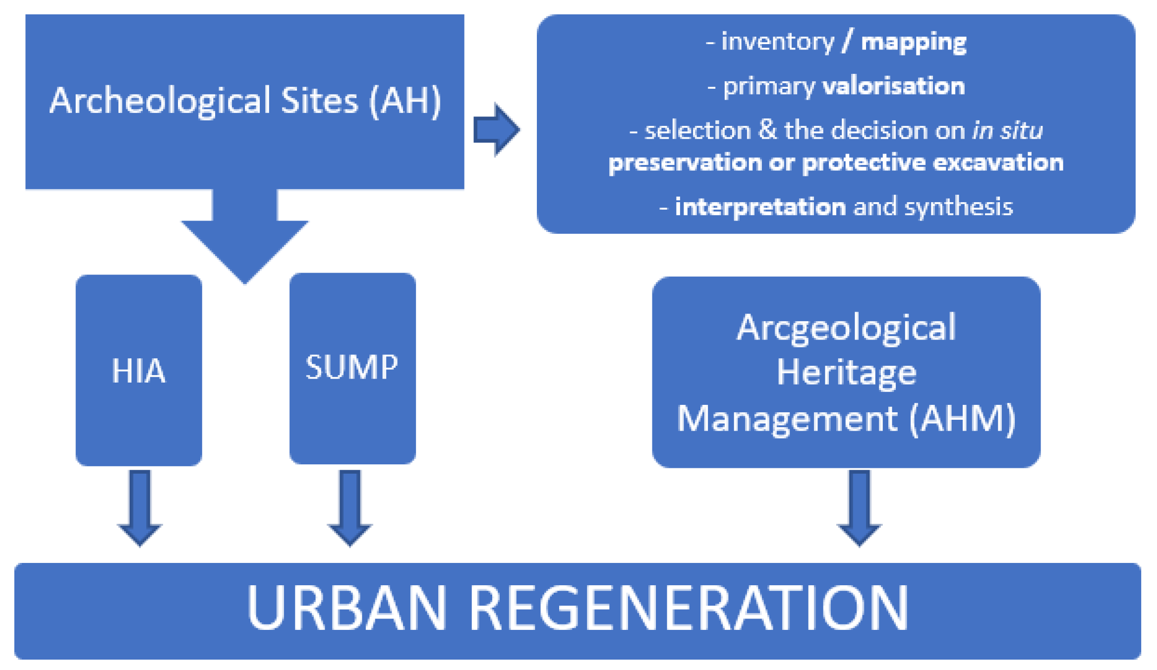
1.1.2. The Process of Managing the Archeological Heritage, Its Presentation, and Its Interpretation In Situ
1.2. Urban Regeneration as a Spatial Planning Principle in the Protection of the Built Environment and Historic Urban Landscape
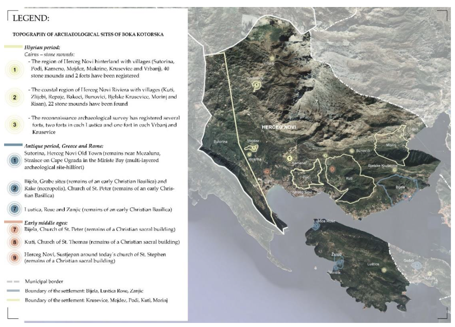
2. Materials and Methods
3. Results
3.1. Heritage Impact Assessment (HIA)
3.1.1. HIA—Impact of Strategic Documents on the Exceptional Universal Value of the Natural and Cultural Heritage of Boka Bay
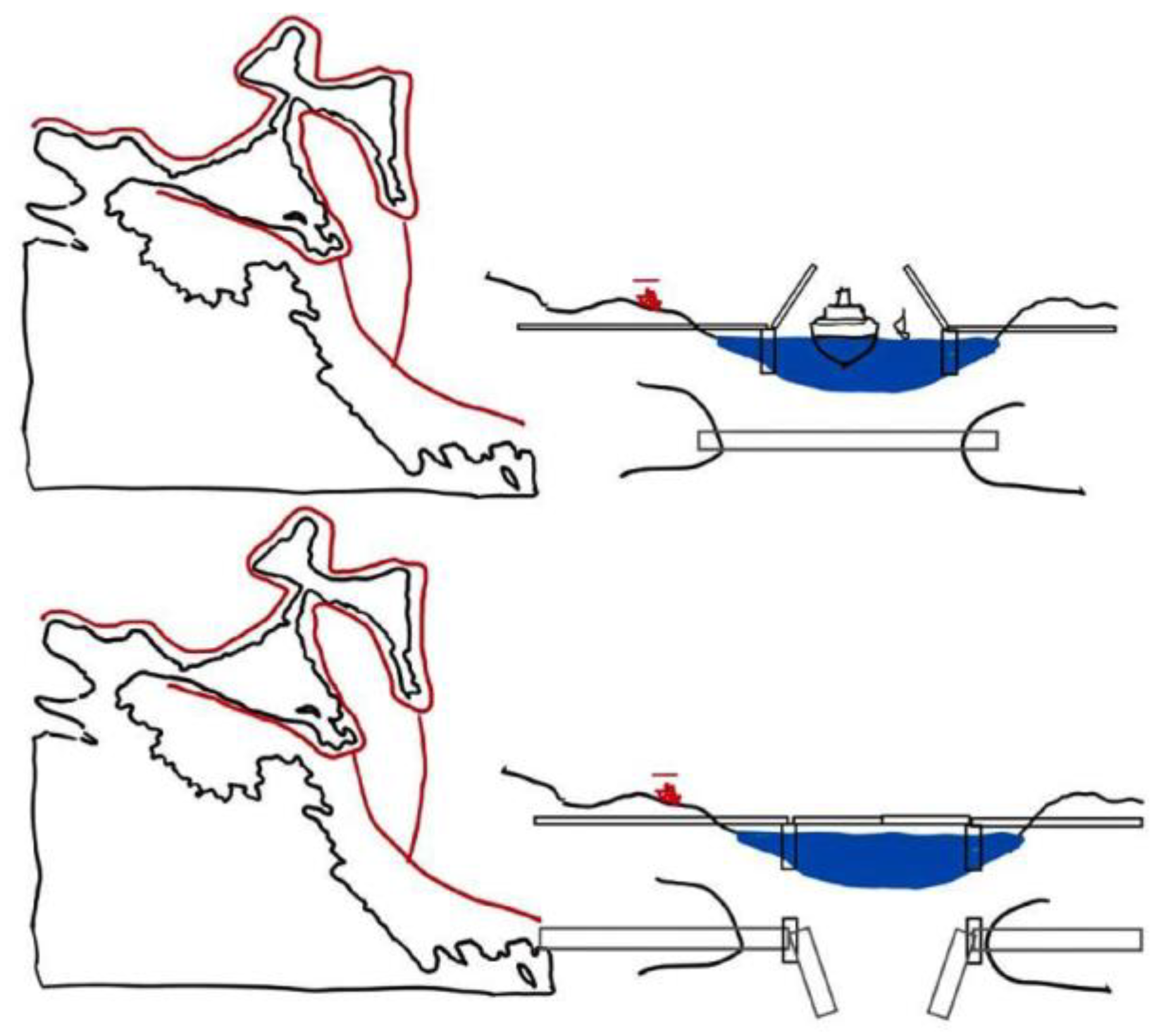
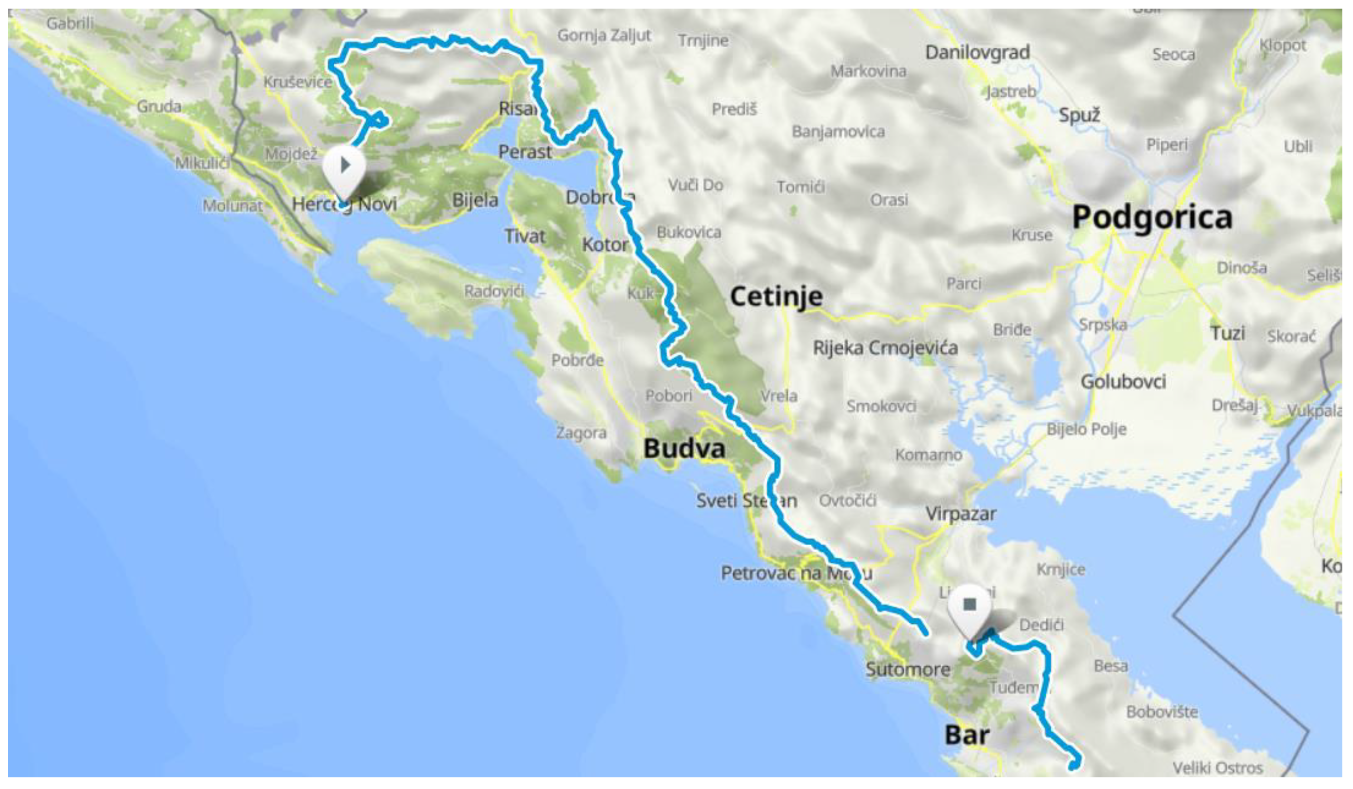
3.1.2. HIA—Urban Mobility and Plan for Construction of the New Bridge “Verige” in Boka Bay
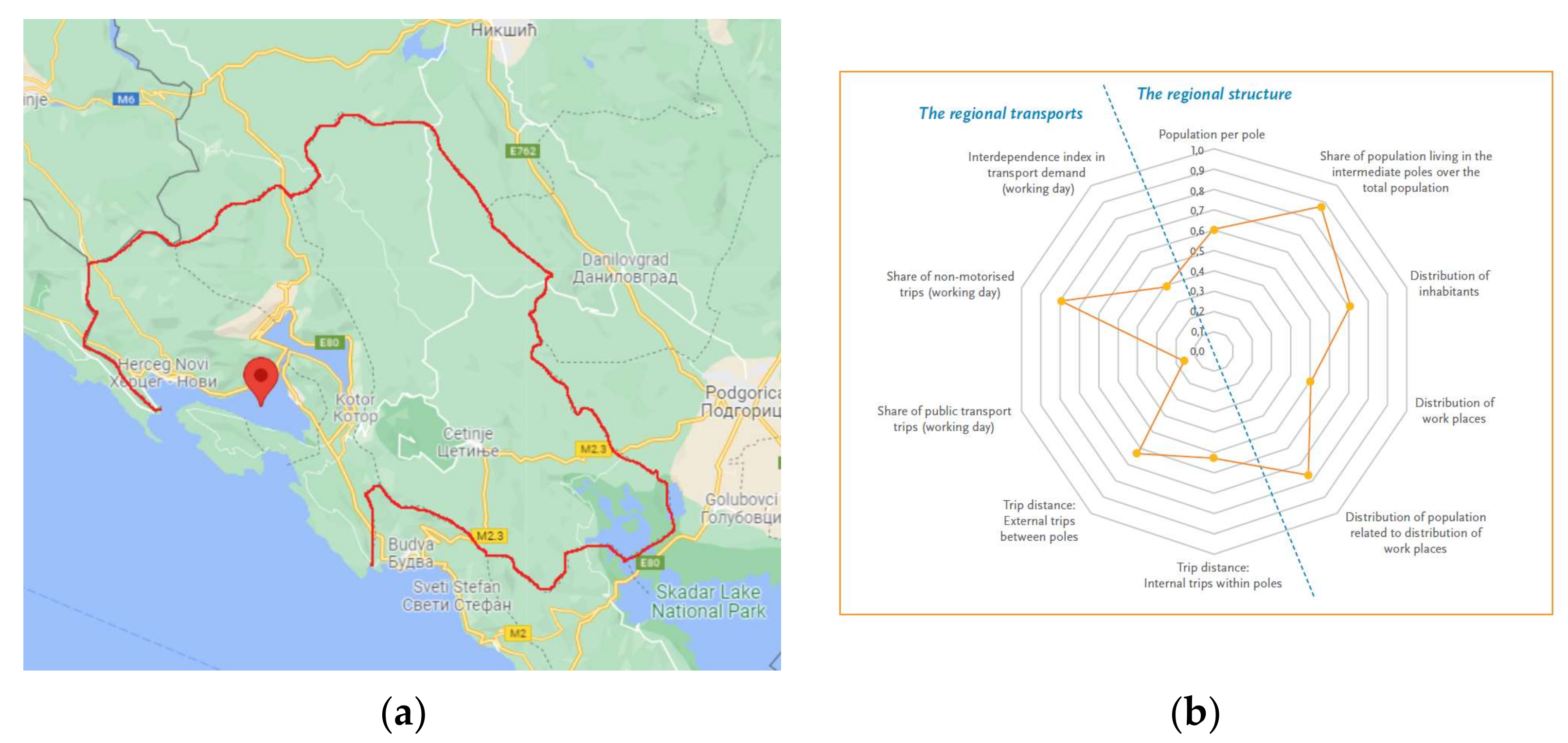
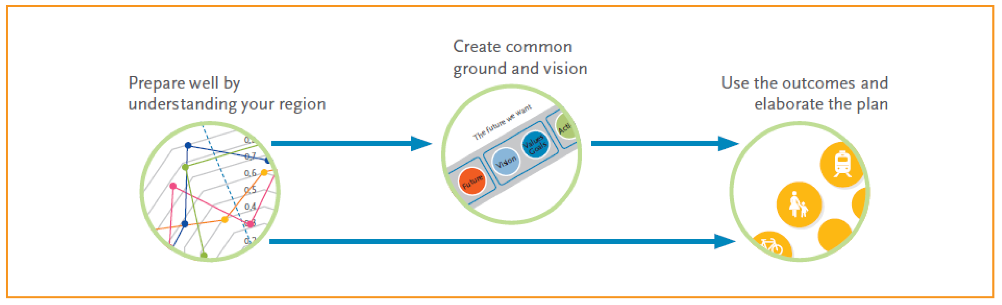
3.2. Sustainable Urban Mobility as a Driver of Heritage Protection and Management and Healthy Environment
4. Discussion and Conclusions
Author Contributions
Funding
Institutional Review Board Statement
Informed Consent Statement
Data Availability Statement
Conflicts of Interest
References
- Willems, W.J.H. Archaeological resource management and preservation. In Preserving Archaeological Remains In Situ, Proceedings of the 3rd Conference Geoarchaeological and Bioarchaeological Studies, Amsterdam, The Netherlands, 7–9 December 2006; Kars, H., Heeringen, R.M., Eds.; Institute for Geo- and Bioarchaeology: Amsterdam, The Netherlands, 2006; pp. 283–289. [Google Scholar]
- Willems, W.J.H. Uncovering Quality Gold. QW 2008, 34, 40–41. [Google Scholar]
- Amado, M.; Rodrigues, E. A Heritage-Based Method to Urban Regeneration in Developing Countries: The Case Study of Luanda. Sustainability 2019, 11, 4105. [Google Scholar] [CrossRef] [Green Version]
- Popovic, M.; Tselenti, N.; Lazarevic, S. Polycentric Sustainable Urban Mobility Plan for Boka Bay and the Old Royal Capital of Cetinje: BokaCet 2020; UNDP Montenegro: Podgorica, Montenegro, 2017; p. 14. [Google Scholar]
- The Rulebook on Detailed Criteria and Procedure for Determining Cultural Values of Goods recognizes the following criteria: Authenticity, integrity, degree of preservation, uniqueness and rarity within their species, historical, artistic, scientific, archaeological, architectural, anthropological, technical or other significance. In Official Gazette of Montenegro; Constitutional Assembly of the Republic of Montenegro: Podgorica, Montenegro, 2011; p. 18.
- Zakon o zaštiti kulturnih dobara. In Official Gazette of Montenegro no. 049/10 from 13.08.2010, 040/11 from 08.08.2011, 044/17 from 06.07.2017, 018/19 from 22.03.2019l; Constitutional Assembly of the Republic of Montenegro: Podgorica, Montenegro, 2019.
- Council of Europe. European Cultural Convention. Paris, 19.XII. 1954. Available online: https://rm.coe.int/168006457e (accessed on 10 December 2021).
- Council of Europe. The European Landscape Convention. Florence. 2000. Available online: https://www.coe.int/en/web/landscape (accessed on 10 December 2021).
- Renfrew, C.; Bahn, P.G. Archaeology: Theories, Methods and Practice; Thames & Hudson: London, UK, 2008; p. 50. [Google Scholar]
- Willems, W.J.H. Archaeological Resource Management and Academic Archaeology in Europe: Some Observations. In Quale Futuro per Lárcheologia; D’Agata, A.L., Alaura, S., Eds.; Dipartimento Patrimonio Culturale, Consigno Nazionale delle Ricerche: Roma, Italy, 2009; p. 94. [Google Scholar]
- Egloff, B.; Comer, D.C. Conserving the Archaeological Soul of Places: Drafting guidelines for the ICAHM Charter. In Proceedings of the 16th ICOMOS General Assembly and International Symposium: “Finding the Spirit of Place—Between the Tangible and the Intangible”, Quebec City, QC, Canada, 29 September–4 October 2008; ICOMOS: Quebec City, Canada, 2008; pp. 1–12. [Google Scholar]
- Willems, W.J.H. Archaeological heritage management and research. In Quo Vadis Archaeologia? Whither European Archaeology in the 21st Century? Proceedings of the European Science Foundation Exploratory Workshop, Madralin near Warsaw, Poland, 12–13 October 2001; Kobylinski, Z., Ed.; European Science Foundation/Institute of Archaeology and Ethnology of the Polish Academy of Sciences/Foundation “Res Publica Multietnica”: Warsaw, Poland, 2001; p. 86. [Google Scholar]
- Carman, J. Archaeology & Heritage. An Introduction; Continuum: London, UK, 2000; pp. 303–308. [Google Scholar]
- UNESCO. Convention Concerning the Protection of the World Cultural and Natural Heritage. 1972. Available online: https://whc.unesco.org/en/conventiontext/ (accessed on 10 December 2021).
- Mijušković, S. Novo Tumačenje Jednog Fragmenta iz “Tabula Peutingeriana”. Istor. Zapisi 1966, 23, 111–129. [Google Scholar]
- Pušič, I. Preistorijski Crteži na Stijeni u Lipcima, Godišnjak IV; Balkan Research Center in Sarajevo: Sarajevo, Bosnia and Herzegovina, 1966. [Google Scholar]
- Pušič, I. Novi Pravac Rimske Ceste Kroz Boku Kotorsku. Istor. Zapisi 1975, 32, 127–131. [Google Scholar]
- Varga, V. Podmorski Arheološki Lokaliteti Njivice—rt Uvala Ribarice; Muzejske Sveske Zavičajnog Muzeja u Herceg Novom: Herceg Novi, Montenegro, 1998; pp. 29–30. [Google Scholar]
- Martinović, J. Ranohrišćanska Krstionica Ispod Crkve Sv. Marije od Rijeke u Kotoru; Prilozi Povijesti Umjetnosti u Dalmaciji: Split, Croatia, 1990; Volume 29, pp. 22–31. [Google Scholar]
- Garašanin, M. Crna Gora u praistorijsko doba. In Istorija Crne Gore—od Najstarijih Vremena do Kraja XII Vijeka, Knj. I; Redakcija za Istoriju Crne Gore: Titograd, Montenegro, 1967. [Google Scholar]
- Mijović, P. Acruvium-Decatera-Kotor u Svijetlu Novih Arheoloških Otkrića. Starinar 1962–1963, 43–44, 13–14. [Google Scholar]
- Mijović, P.; Kovačević, M. Gradovi i Utvrđenja u Crnoj Gori; Arheološki Institut: Beograd, Serbia; Muzej Ulcinj: Ulcinj, Montenegro, 1975. [Google Scholar]
- Mijović, P. Urbani Razvoj Crne Gore u Anticko Doba-Buthua-Olcinium-Bar; Obod: Cetinje, Montenegro, 1975. [Google Scholar]
- Bošković, Đ. Osvrt na Neke Zamke Koje Očekuju Istraživača Prilikom Identifi-Kovanja Konstrukcija Predantičkog i Antičkog Doba. In Proceedings of the Conference: Materijali, Tehnike i Strukture Predantičkog i Antičkog Graditeljstva na Istočnom Jadranskom Prostoru, Zadar, Croatia, 6–8 December 1976. [Google Scholar]
- Jovanović, A. Pимcкe Нeкpoпoлe нa Тepитopиjи Jyгocлaвиje; Univerzitet u Beogradu: Belgrade, Serbia, 1984. [Google Scholar]
- Čubrović, Z. Ka Пoзнaвaњy Ypбaниcтичкoг Paзвoja Пepacтa; Бoкa 23, Gradska Biblioteka i Čitaonica: Herceg Novi, Montenegro, 2003. [Google Scholar]
- Lisavac, K. Пaлaтa Змajeвић y Пepacтy; Бoкa 23, Gradska Biblioteka i Čitaonica: Herceg Novi, Montenegro, 2003. [Google Scholar]
- Ilijanić, B. Zbornik Radova BOKA; Gradska Biblioteka i Čitaonica: Herceg Novi, Montenegro, 2009. [Google Scholar]
- Ilijanić, B. Urbana Geneza—Rektifikacija Starih Planova Herceg Novi—Stari Grad, Crna Gora, Istočna Obala Jadranskog Mora. Istraživački Rezime; Ilibo Design Architects: Herceg Novi, Montenegro, 1998. [Google Scholar]
- Ilijanić, B. Resinum Romanum—Herceg Novi; Ilibo Design Architects: Herceg Novi, Montenegro, 2018–2019. [Google Scholar]
- Lalošević, I. Φopтиφикaцaoни Cиcтeми Пepacтa. God. Pomor-Skog Muz. Kotor 1995–1998, 43–44. [Google Scholar]
- Lalošević, I. Obnova i Zaštita Istorijskih Građevina Područja Kotora Nakon Zemljotresa 1979. Godine; Boka 34; Zbornik Radova Iz nauke, Kulture i Umjetnosti; Gradska Biblioteka i Čitaonica: Herceg Novi, Montenegro, 2014. [Google Scholar]
- Lalošević, I. Utvrđeni Punktovi Kotorske Tvrđave Venecijanskog Perioda; Boka 40; Zbornik Radova iz Nauke, Kulture i Umjetnosti; Gradska Biblioteka i Čitaonica: Herceg Novi, Montenegro, 2010. [Google Scholar]
- Cleere, H. World cultural resource management: Problems and perspectives. In Approaches to the Archaeological Heritage; Cleere, H., Ed.; Cambridge University Press: Cambridge, UK, 1984; p. 125. [Google Scholar]
- Willems, W.J.H. Archaeology and Heritage Management in Europe: Trends and Developments. EJA 1998, 1, 295. [Google Scholar] [CrossRef]
- Pedregal, P.D.; Diekmann, A. How to Reconcile Archeological Site Protection and Visitor Accessibility? Getty Publications: Los Angeles, CA, USA, 2012; p. 773. ISBN 978-1-60606-124-4. [Google Scholar]
- Nicolau, A.; Nicolau, M. Interpretation and Display. In Urban Pasts and Urban Futures: Bringing Urban Archaeology to Life—Enhancing Urban Archaeological Remains, International and Interdisciplinary Symposium; EU Committee of the Regions: Brusseles, Belgium, 2005; p. 31. [Google Scholar]
- Begović, B. Ekonomika Urbanističkog Planiranja; Centar za Ekonomske Studije: Beograd, Serbia, 1995; p. 348. [Google Scholar]
- Moughtin, C. Urban Design: Street and Square, Routledge; Taylor & Francis Group: Abingdon-on-Thames, UK, 2003; ISBN 9780750657174. [Google Scholar]
- Vaništa-Lazarević, E. Obnova Gradova u Novom Milenijumu; Classic Map Studio: Beograd, Serbia, 2003. [Google Scholar]
- Bazik, D. Iniciranje regeneracije javnih gradskih prostora. In Urbani Dizajn; Bogdanović, R., Ed.; Društvo Urbanista Beograda: Beograd, Serbia, 2006; pp. 259–272. [Google Scholar]
- Serraino, M.; Lucchi, E. Energy Efficiency, Heritage Conservation, and Landscape Integration: The Case Study of the San Martino Castle in Parella (Turin, Itlay). Energy Procedia 2017, 11, 4483. [Google Scholar] [CrossRef]
- Amado, M. How to Transform Today’s City; Caleidoscopio–Edição e Artes Gráficas S.A.: Lisbon, Portugal, 2019. [Google Scholar]
- United Nations. Transforming Our World: The 2030 Agenda for Sustainable Development. Available online: https://sdgs.un.org/2030agenda (accessed on 7 November 2021).
- United Nations. Habitat III, New Urban Agenda. Available online: http://habitat3.org/wp-content/uploads/New-Urban-Agenda-GA-Adopted-68th-Plenary-N1646655-E.pdf (accessed on 7 November 2021).
- UNESCO. Recommendation on the Historic Urban Landscape. Available online: https://whc.unesco.org/en/hul/ (accessed on 7 November 2021).
- Nicholson, C. Mobility 2030: Meeting the Challenges to Sustainability: The Sustainable Mobility Project; Full Report 2004; World Business Council for Sustainable Development: Conches, Geneva, 2004. [Google Scholar]
- SUMP: Sustainable Urban Mobility Plan—European Platform on Sustainable Urban Mobility Plan—ELTIS. Available online: www.eltis.org/mobility-plans (accessed on 15 May 2021).
- Poly-SUMP: Policentric Sustainable Urban Mobility Plan—Planning Sustainable Mobility Together. Available online: http://www.poly-sump.eu/ (accessed on 15 May 2021).
- Ministry of Culture of Montenegro. Menadžment Plan Prirodnog i Kulturno—Istorijskog Područja Kotora; Ministry of Culture of Montenegro: Cetinje, Montenegro, 2011. [Google Scholar]
- Ministry of Ecology, Spatial Planning and Urbanism. Montenegro Tourism Development Strategy to 2020; Ministry of Ecology, Spatial Planning and Urbanism: Podgorica, Montenegro, 2011. [Google Scholar]
- Arbutina, D.; Popović, G.S. Heritage Impact Assessment for the Natural and Cultural-Historical Area of Kotor—Plan to Build a Bridge at the Verige Site; Architectural faculty of University of Montenegro: Podgorica, Montenegro, 2017. [Google Scholar]


| Group of Factors | Group of Factors 1 | Group of Factors 2 | Group of Factors 3 | Group of Factors 4 |
|---|---|---|---|---|
| A group of factors relating to legislative issues and law enforcement, and by-laws | Obsolescence and inconsistency of the Law on the Protection of the Monumental Entity of Kotor with the new Law on the Protection of Cultural Heritage and other systemic laws | Lack of legal obligation to prepare studies of visual impact on natural and cultural values of the Kotor Area in the process of preparation of planning and project documentation | Insufficient professional and inspection supervision to prevent illegal construction and works | Non-compliance with laws and bylaws |
| Management issues and the problem of adequate personnel equipment | Inadequate space Management | |||
| Lack of a Managing Authority in accordance with UNESCO guidelines (agencies, councils, etc.) | Insufficient training of professional profiles for planning, design, and execution of works for areas with a high concentration of cultural assets | Insufficient professional capacities in the study, protection, conservation, and restoration of cultural heritage | Lack of staff capacity, lack of clear strategic staffing policy and lack of specialized educational institutions for education and training of staff in the field of cultural heritage | |
| Inadequate monitoring of all activities in the protected area and contact environment area | ||||
| Insufficient coordination between subjects in the system of protection and management | Insufficient professional capacities for performing works in traditional techniques | |||
| Planning and spatial planning issues | Lack of Area Management Plan Obsolete urban planning documents, especially plans of the highest rank for the coverage of the Municipality of Kotor (PPO and GUP), i.e., failure to adopt the Spatial Urban Plan of the Municipality | Discrepancy of development concepts with the spatial potentials of the protected area and the restrictions set by the protection criteria (large tourist complexes, traffic infrastructure, infrastructure technologies: plants, stations, reservoirs, warehouses) | Inconsistency of standard planning concepts of inherited condition improvement heritage with prescribed protection criteria and principles of respect for values traditional architecture Uncoordinated order of preparation and adoption of planning documents | |
| Economic and infrastructure problems | Lack of permanent sources and a continuous way of acquiring funds for the protection and improvement of the state of cultural heritage | Insufficient care and maintenance of cultural goods by owners and users | Insufficient and untimely investment in infrastructure | The unsatisfactory condition of traffic infrastructure, insufficient parking capacities space and insufficient use of water for regular transport of local population and tourists in the Bay of Kotor and Risan |
| Non-collection of associated communal revenues based on the use of natural and cultural assets | Non - advancing incentive measures for owners of cultural property for storage, maintenance and implementation of protection measures | Insufficiently clear strategic vision for the development of tourism in the protected area and inadequate tourism valorization of cultural goods | ||
| Lack of accommodation - hotel capacity | Insufficient adaptation of infrastructure for people with disabilities | |||
| Conservation and museological problems | Insufficient research, professional valorization of space, lack of protection studies cultural assets for all settlements of the area, as well as the undefined protected environment of the Area | Illegal and unprofessional works on cultural goods and non-compliance with the principles of protection | Failure to implement normative and documentary protection of movable, immovable and intangible cultural heritage, prescribed by law | Lack of space for storage, protection, and presentation of movable cultural property, especially archaeological finds in the Kotor area |
| Lack of study of the cultural landscape of the area and the Bay of Kotor | Inadequate physical protection of cultural property on land and underwater consequently in particular, there is the illegal extraction of archaeological objects from the seabed | Inadequate museum spaces and depots for safe storage of museum objects and their protection from theft, vandalism, fire, and other harmful influences that may occur anticipate, as well as the untimely and inadequate implementation of conservation treatment of the museum material | ||
| Inadequate conditions for the preservation of wall paintings, iconostasis, and paintings on canvas and wood in the interior of the church | ||||
| Social problems | Insufficiently developed awareness of the values and potentials of space | Insufficient and inadequate education of the society, especially the school population about the values and potentials of the protected area | Population migration caused by real estate sales | Lack of professional staff |
| Insufficient level of awareness of the population about the values of the protected area as development potentials | Extinction of old crafts | |||
| Environmental problems | Uncontrolled exploitation of plant species, which destroys the habitats of many species, the appearance of the landscape and the living conditions of plants and animals are changing | Unprofessional and illegal works, related to the filling and expansion of natural beaches and the coastline with artificial stone and the reconstruction of the bridge with concrete and other modern materials, which destroy the ecosystems of the coastal sea | Illegal discharge of sewage into the sea | Filling of rubble and other construction waste into the sea |
| Overfishing | Insufficient discharge control from large ships and cruisers | Uncontrolled construction in the coastal part | ||
| Lack of a special ship for cleaning the sea surface |
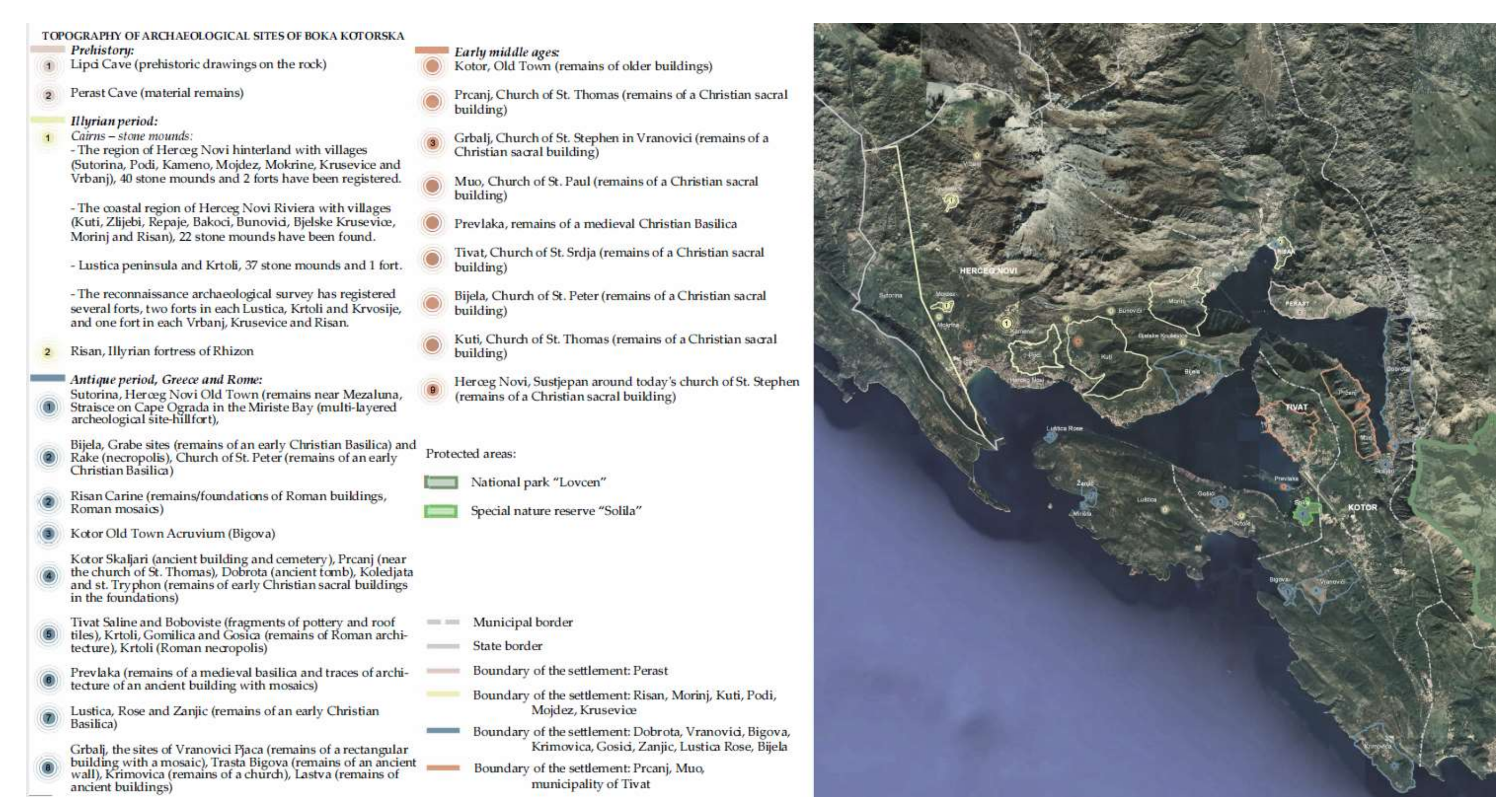
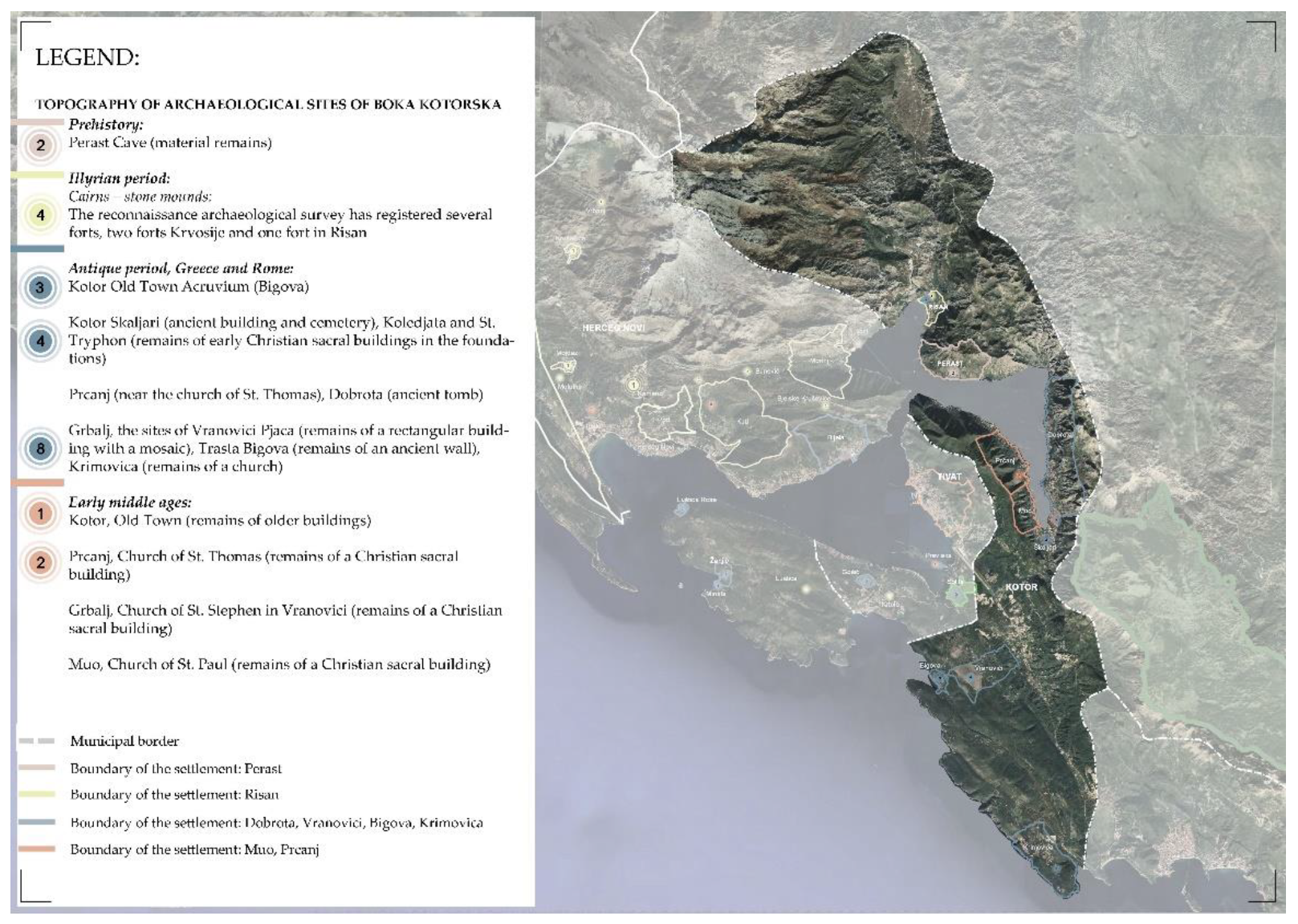
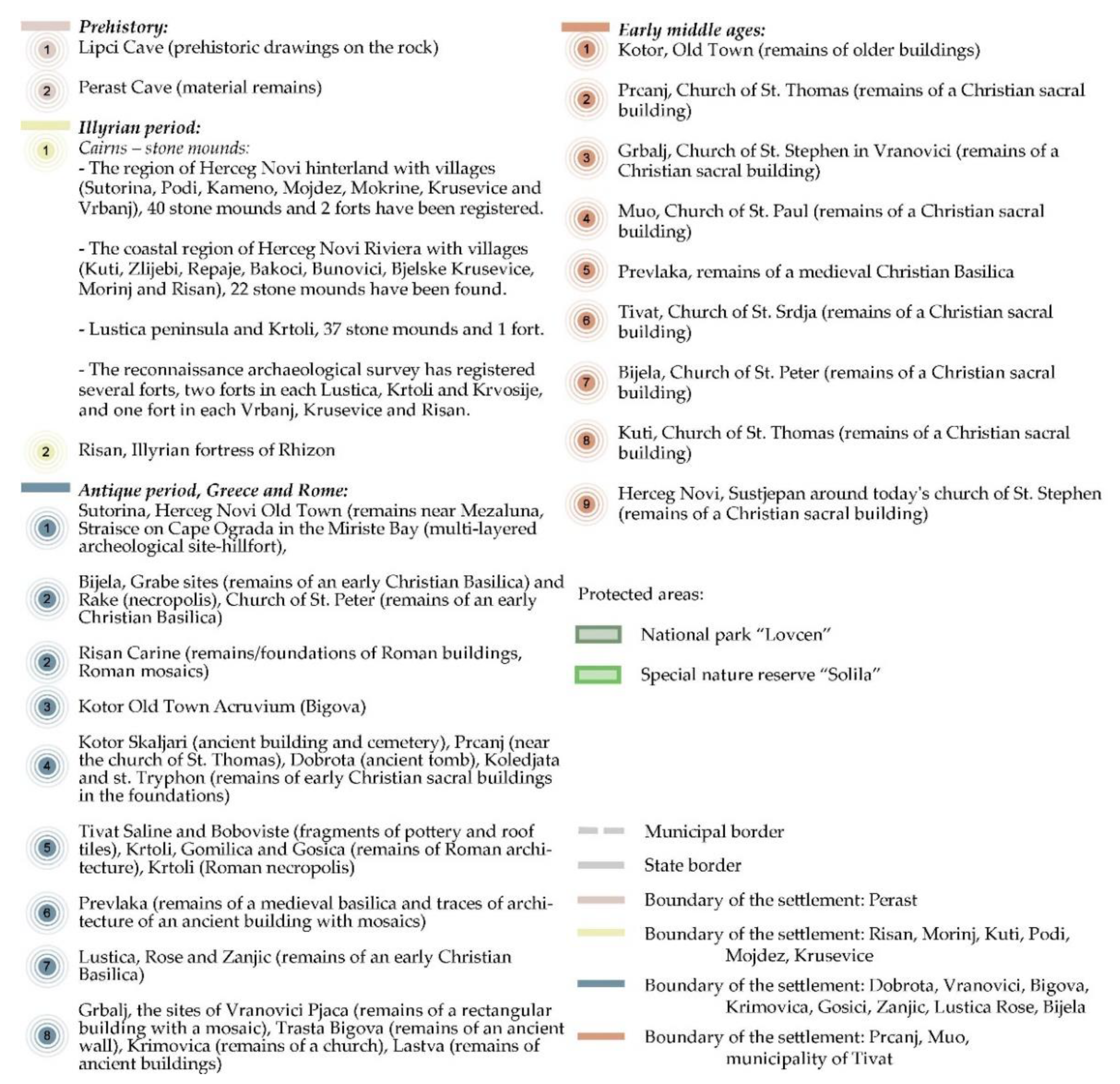
| Number of the Archaeological Sites per Its Existing Situation/Sort | ||||||||
|---|---|---|---|---|---|---|---|---|
| City/ Type of Sites | Total no. of Sites per Periods | Drawings and Mosaics | Material Remains | Forts -Stone Mounds | Fortress | Necropolis and Sacral Buildings | Fortified Towns | Multi-Layered Archaeological Site |
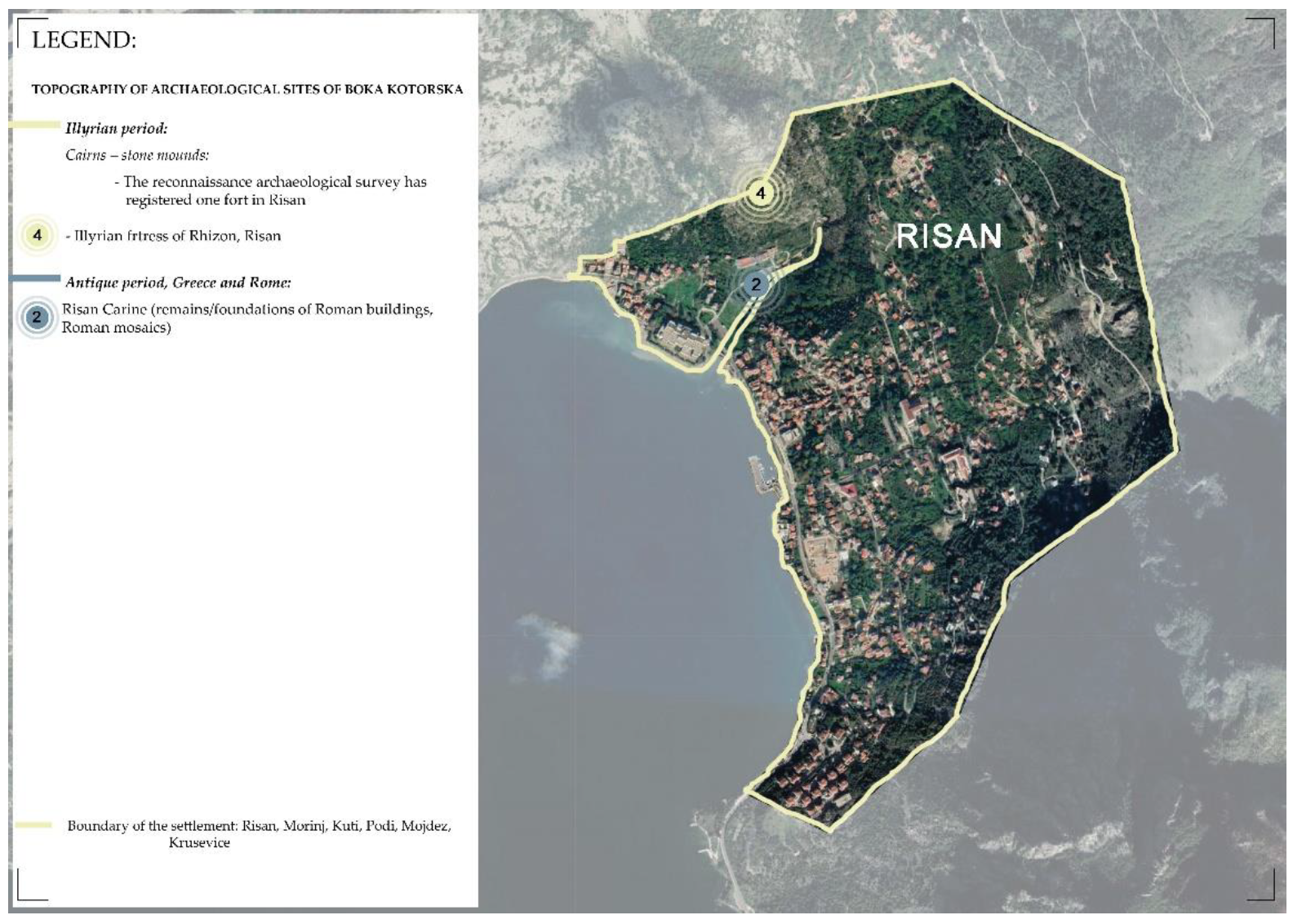
| RISAN | ||||||||
| Prehistory | x | x | x | x | x | x | x | x |
| Illyrian period | 2 | x | x | 1 | 1 | x | x | x |
| Antique period | 2 | 1 | 1 | x | x | x | x | x |
| Early Middle Ages | x | x | x | x | x | x | x | x |
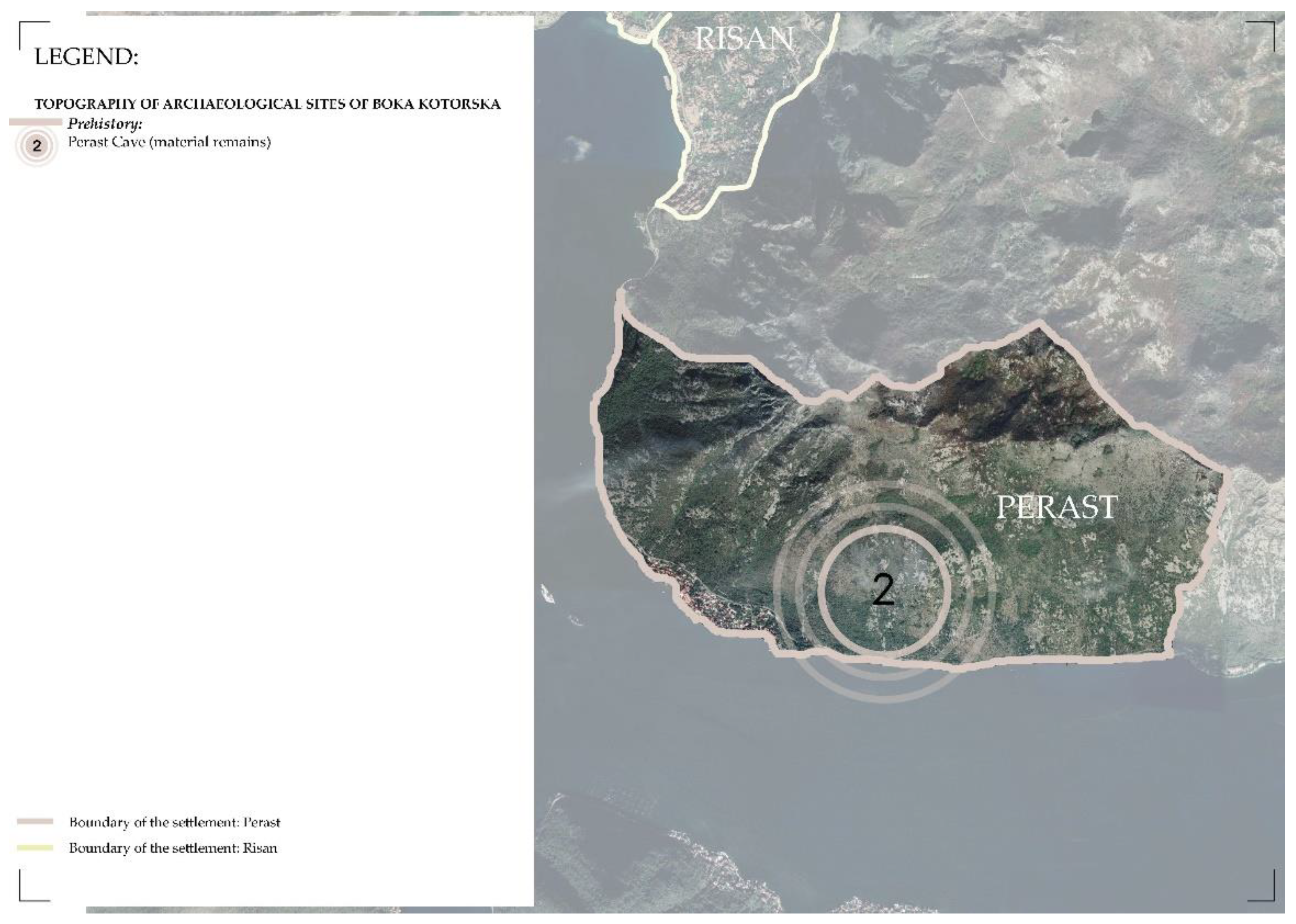
| PERAST | ||||||||
| Prehistory | 2 | x | 2 | x | x | x | x | x |
| Illyrian period | x | x | x | x | x | x | x | x |
| Antique period | x | x | x | x | x | x | x | x |
| Early Middle Ages | x | x | x | x | x | x | x | x |
| KOTOR | ||||||||
| Prehistory | 2 | x | 2 | x | x | x | x | x |
| Illyrian period | 4 | x | 1 | 3 | x | x | x | x |
| Antique period | 9 | x | 2 | x | x | 5 | 1 | 1 |
| Early Middle Ages | 4 | x | x | x | x | 3 | 1 | x |
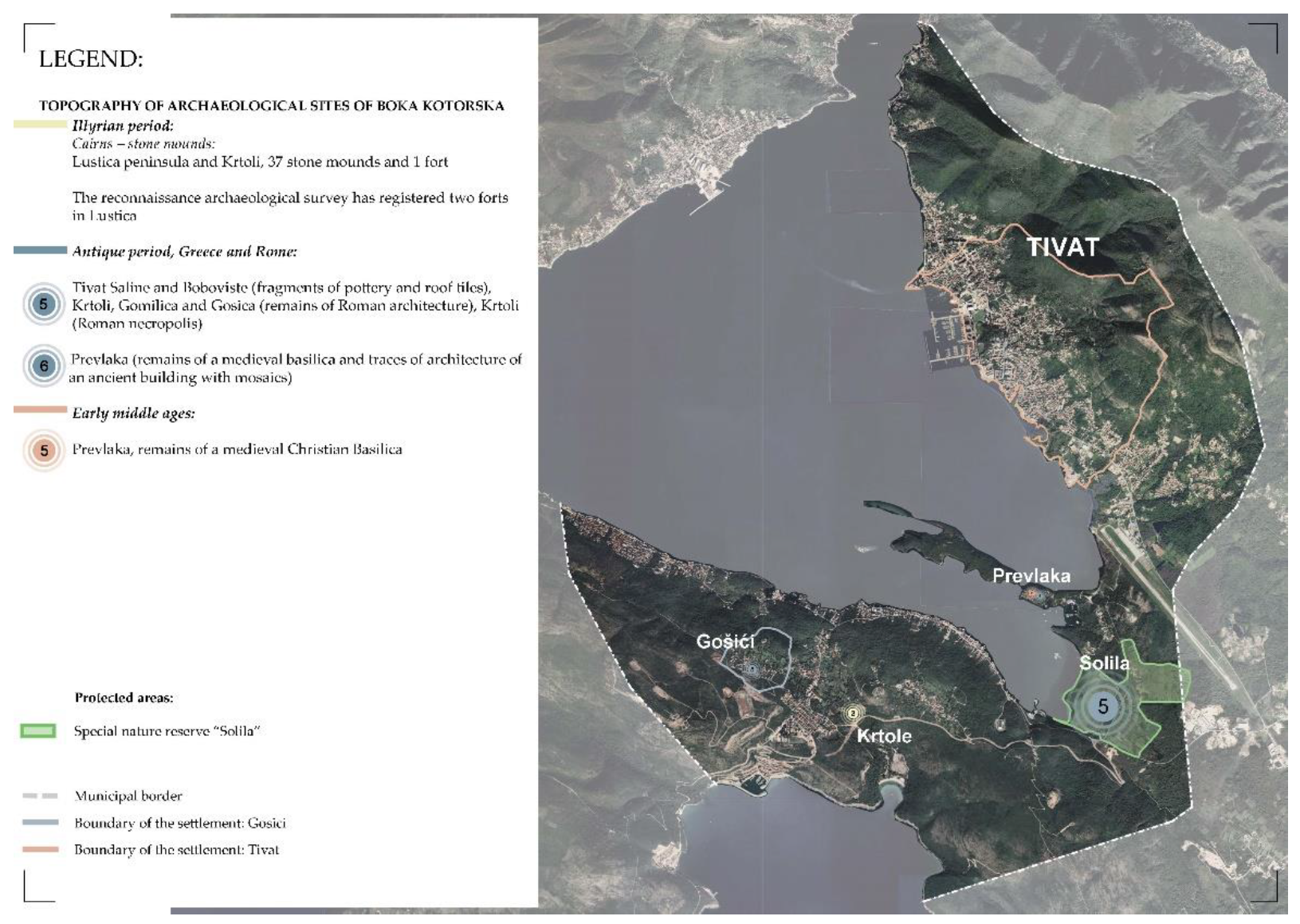
| TIVAT | ||||||||
| Prehistory | x | x | x | x | x | x | x | x |
| Illyrian period | 3 | x | 1 | 2 | x | x | x | x |
| Antique period | 41 | x | 37 | x | x | 3 | x | 1 |
| Early Middle Ages | 1 | x | x | x | x | 1 | x | x |
| HERCEG NOVI | ||||||||
| Prehistory | x | x | x | x | x | x | x | x |
| Illyrian period | 68 | x | 62 | 6 | x | x | x | x |
| Antique period | 7 | x | 1 | x | x | 3 | x | 3 |
| Early Middle Ages | 3 | x | x | x | x | 3 | x | x |
Publisher’s Note: MDPI stays neutral with regard to jurisdictional claims in published maps and institutional affiliations. |
© 2022 by the authors. Licensee MDPI, Basel, Switzerland. This article is an open access article distributed under the terms and conditions of the Creative Commons Attribution (CC BY) license (https://creativecommons.org/licenses/by/4.0/).
Share and Cite
Lazarević, S.; Arbutina, D.; Popović, S.G. The Role of the Archeological Heritage Sites in the Process of Urban Regeneration of UNESCO’s Cities—Boka Bay Case Study. Sustainability 2022, 14, 1566. https://doi.org/10.3390/su14031566
Lazarević S, Arbutina D, Popović SG. The Role of the Archeological Heritage Sites in the Process of Urban Regeneration of UNESCO’s Cities—Boka Bay Case Study. Sustainability. 2022; 14(3):1566. https://doi.org/10.3390/su14031566
Chicago/Turabian StyleLazarević, Slađana, Dražen Arbutina, and Svetislav G. Popović. 2022. "The Role of the Archeological Heritage Sites in the Process of Urban Regeneration of UNESCO’s Cities—Boka Bay Case Study" Sustainability 14, no. 3: 1566. https://doi.org/10.3390/su14031566
APA StyleLazarević, S., Arbutina, D., & Popović, S. G. (2022). The Role of the Archeological Heritage Sites in the Process of Urban Regeneration of UNESCO’s Cities—Boka Bay Case Study. Sustainability, 14(3), 1566. https://doi.org/10.3390/su14031566