Review

Interdisciplinary Inquiry and Spatial Green Stormwater Infrastructure Research

1
Stuart Weitzman School of Design, University of Pennsylvania, Philadelphia, PA 19104, USA
2
School of Public and International Affairs, Virginia Tech, Blacksburg, VA 24060, USA
3
School of Public and International Affairs, Arlington Campus, Virginia Tech, Arlington, VA 22203, USA
*
Author to whom correspondence should be addressed.
Sustainability 2022, 14(3), 1198; https://doi.org/10.3390/su14031198
Submission received: 9 December 2021 / Revised: 13 January 2022 / Accepted: 18 January 2022 / Published: 21 January 2022

Abstract

:
The use of vegetation and infiltration into soils to manage stormwater and water quality—called green stormwater infrastructure (GSI)—is now widely recognized as a viable alternative or supplement to the pipes and pumps of conventional, or “gray”, drainage infrastructure. Over the years, much research has emerged regarding spatial aspects of GSI implemented at large scales, including where it is located, where it should be located, and what metrics best represent the benefits it brings to different locations. Research in these areas involves expertise from multiple academic disciplines, but it is unclear whether and how researchers from different disciplines identify and approach questions related to the spatiality of GSI. By adopting the explanatory sequential mixed method design, we identified four categories of spatial GSI studies through a literature review of over 120 research papers: empirical, ecological, decision support systems, and optimization. Here, we present representative examples of these categories of spatial GSI studies, as well as associations between the academic disciplines represented in these categories of spatial GSI papers. Then, we conducted semi-structured interviews with a sample of GSI researchers which revealed the value of interdisciplinary training and knowledge. Finally, in this paper, we identify several gaps that could be addressed to improve interdisciplinary research on GSI implementation, and sustainability transitions in general.

1. Introduction

Green stormwater infrastructure (GSI) is becoming an increasingly popular approach to overcoming the limitations of traditional gray infrastructure systems that are facing issues of deferred maintenance and are unable to adequately manage stormwater under conditions of climate and land use change. Many administrators view GSI as an alternative solution to the problem of aging water infrastructure. Furthermore, stormwater runoff in GSI is utilized by plants and soil resources within cities, which means that its benefits are not limited to sewage system maintenance or upgrading nature-based stormwater control and management [1,2]; GSI is also a means of greening cities, providing local citizens access to nature, and restoring stream health and water quality [3,4].
With the growing acceptance of GSI, questions are shifting from whether or not cities should implement GSI to more practical issues, such as where it tends to be located, where it should be located, and how GSI networks can be planned and designed so that they create the maximum benefits for communities [5,6,7]. These questions address the spatiality of GSI as a network, rather than individual best management practices.
More widespread implementation of networks of green infrastructure practices such as rain gardens and bioswales addresses fundamentally different challenges compared to conventional gray infrastructure systems, making green infrastructure research more cross-disciplinary [8,9,10]. Cross-disciplinary research is an umbrella term that encompasses multi-, inter-, and trans-disciplinary research along a continuum. On one end of the continuum is multidisciplinary research, which is the least integrative form of collaborative or team-based research. While multidisciplinary research teams involve members from two or more disciplines, with each member bringing a different perspective to understand or address the problem, they do not result in integrative conceptualizations or frameworks, or new techniques or models that integrate or transcend the confines of a single discipline. Interdisciplinary research, on the other hand, integrates information, data, methods, tools, concepts, or theories from two or more disciplines to address a particular problem or question. Transdisciplinary research transcends disciplinary worldviews by generating overarching conceptual and methodological frameworks that cross disciplinary boundaries by engaging stakeholders in the co-production of knowledge [11,12]. Tools that aid interdisciplinary collaboration often focus on facilitating knowledge sharing by making explicit assumptions about relevant system components, causal relationships, and the directionality of relations. Examples of these tools include collaborative conceptual modeling, focused dialogic approaches for collaborative problem conceptualization, and qualitative modeling techniques such as concept maps, mind maps, and causal loop diagrams [13].
Most GSI projects require some level of cross-disciplinary collaboration among experts in different fields, such as civil engineering, hydrology, urban planning, ecology, landscape architecture, and economic and behavioral sciences. Each of these disciplines brings its own disciplinary perspectives, theories, and methodologies to the framing of complex spatial GSI problems [14]. In this study, we are particularly interested in identifying the extent to which spatial GSI research has incorporated the cross-disciplinary framing of research questions and cross-disciplinary methods. By conducting a systematic literature review of over 120 papers addressing the spatiality of GSI as a network, we address the following research questions (RQ):
  • RQ1: What patterns can be identified in the stated motivations, assumptions, and research approaches in current spatial GSI research?
  • RQ2: How do these patterns relate to how different disciplines frame and approach research?
  • RQ3: What is needed to improve cross-disciplinary research for spatial GSI?

2. Background: What Is Spatial GSI Research?

Currently, there is no universal definition of “green infrastructure” [15,16,17]. Over 40% of the publications on green infrastructure do not provide an explicit definition of what is meant by the term. The lack of a singular clear definition of green infrastructure has made it a widely evocative term that has allowed researchers and practitioners the flexibility to focus on what they believe is important. Concepts including blue infrastructure, ecosystem services, and nature-based solutions share similar boundary-spanning characteristics. A thorough review of the literature, however, has revealed that “green infrastructure” mainly refers to three concepts: (1) a greenspace planning concept, (2) an urban ecology concept, and (3) a water/stormwater management concept [17]. Despite being an evocative concept, the widespread implementation of green infrastructure faces challenges of urban governance and physical and social path dependence. This results in barriers to implementation: the path dependence of gray infrastructure obstructs the implementation of green infrastructure by government officials and the greater public [18].
In this research, we focus on green stormwater infrastructure (GSI), a conceptualization of green infrastructure that is directly related to the infrastructure that manages drainage and mitigates flooding in urban areas. In the United States, much of the technical acceptance of GSI was spurred by regulatory acceptance of engineered rain gardens, bioswales, and permeable pavement as technologies that could reduce the prevalence of combined sewer overflows, which occur when wet-weather events result in the discharge of untreated sewage from sewer systems that collect both stormwater runoff and domestic and industrial wastewater into the same, aging pipe network [19]. In this conceptualization, natural elements such as infiltration into soils and evapotranspiration from vegetation are used to reduce or delay the volume of runoff entering combined sewer systems, and thus prevent combined sewer overflows. Technical acceptance of GSI has been supported by a large body of empirical research on the effectiveness of individual GSI facilities to reduce volumes and delay peaks in runoff [20,21,22,23]. GSI also leads to water quality benefits, as rain gardens and bioswales have been shown to reduce sediment, pollutant retention, and nutrient transport from urban land uses to surrounding rivers and streams. Therefore, GSI has been accepted as a best management practice for drainage systems that complement existing sewer systems [24,25,26,27]. Other countries employ similar approaches to stormwater management, such as water-sensitive urban design (WSUD), sustainable urban drainage systems (SUDS), blue-green infrastructure, and sponge cities [17]. It should also be noted that the physical, morphological, cultural, political, ecological, climatic, socio-economic, and planning conditions in which GSI and similar approaches are implemented vary enormously. Particularly notable is the difference in goals between older cities seeking to update aging infrastructure using GSI and new developments seeking to mitigate the effects of urbanization on the pre-development aquatic environment and hydrological cycle.
GSI benefits extend beyond reducing flooding and improving water quality. GSI could restore the healthy stream flows in rivers and streams by increasing infiltration into soils rather than quickflow surface runoff typical of urbanized watersheds [27,28,29,30]. However, there is evidence that the spatial location of infiltration opportunities within a watershed is an important factor to consider [26,31,32]. Some researchers have considered these questions by examining the spatial dependence of urban variable source areas, in terms of where and how surface runoff is produced. Others have considered interactive or synergistic effects between infiltration opportunities [33,34].
Other co-benefits have also been identified. GSI has been found to require lower capital costs more than increasing the capacity of buried pipes systems would, therefore saving resources for cash-strapped municipal budgets [35,36,37]. GSI has also been associated with increased property values [38,39,40,41], has been found to have aesthetic and beautification value in urban neighborhoods [42,43], and creates habitats and increases biodiversity [44]. GSI is associated with lower crime rates and can be used to rehabilitate blighted or vacant land [45,46]. Additionally, vegetation and trees used for GSI may reduce air pollution, urban temperatures, and heat island effects [47,48,49]. GSI can be co-located with community gardens and schools to address food access issues and improve community engagement and place-based learning opportunities [50,51,52]. Thus, the management of GSI by the government is comprehensive rather than solely environmental. Many local governments rely on external funding to meet the costs of GSI [53].
However, despite these potential opportunities, the question of where GSI is located could have undesirable social and economic effects. Compared to traditional drainage infrastructure, which is currently located beneath the public right-of-way, much of the cost-savings associated with GSI is often presumed to come from reduced costs of building on the surface rather than underground, and on private rather than public property [35]. Some researchers view GSI implementation through a critical lens of environmental justice. For example, across the heterogeneity of cities, costs may be highly variable. Maintenance costs of GSI on private property borne by the property owner rather than city maintenance crews can be viewed as placing burdens of public service provision on residents themselves [53]. In St. Louis, MO, USA, the locations of GSI investments and the logic of cost savings were found to reinforce rather than challenge decades of unequal public service provision [54]. Working on private property will often require the voluntary willingness of property owners and depend on private residents’ variable preferences for participating in public/environmental programs and access to information, which also vary across communities and space [42,55,56]. Where the co-benefits of constructed GSI will accrue, to whom, and by what decision-making process have implications for equitable distribution, fairness, and participatory processes [57,58,59].
The literature indicates that there are multiple reasons to look beyond the evaluation of single GSI facilities and focus on the implications of GSI networks. Furthermore, the literature illustrates the many considerations that must be taken into account when studying the effectiveness of a spatialized GSI network serving diverse populations with multiple benefits [60,61]. Finally, it also emphasizes the need to conceptualize spatial GSI questions holistically, necessitating inter- and transdisciplinary approaches that aim to integrate multiple potentially competing goals and identify synergies between divergent disciplinary perspectives and methods, if the implementation of GSI is to occur on a larger scale.

3. Methods

In this study, we used an explanatory sequential mixed method design, or a two-phase model, which consists of a quantitative data analysis followed by a qualitative study that elaborates and explains the findings of the quantitative portion of the research [62,63]. In this type of research, sample size is not an indicator of rigor or validity [64]. The philosophy of this model is that the quantitative analysis builds an overall image of the issue that the qualitative studies then elaborate on, supplementing the issue with more in-depth details [63]. The purpose of the interviews, therefore, is not to generate thick descriptions or aim for the saturation of data as a purely qualitative study.

3.1. Literature Review and Coding Papers

First, to understand the current state of spatial GSI research, as RQ1 asks, we conducted a systematic literature review of papers addressing the spatiality of GSI as a network. We collected all publications from 2009 to the early half of 2020, by applying the keyword searches shown below to the indexed databases available on Web of Science Core Collection.
TS = (“green infrastructure” OR “Low impact development” OR “water sensitive urban design” OR “sustainable urban drainage system” OR “sponge city”) AND TS = (“location” OR “spatial” OR “distribution” OR “site selection”) AND TS = (“stormwater”)
This resulted in 214 papers. We then filtered the papers for relevance to green stormwater infrastructure, in English, and whether they addressed more than one GSI facility (for example, not merely evaluating the performance of a single rain garden or bioswale). In the end, 127 papers were included in this study.
In each of the studies we reviewed, we developed codes that represented the basis of knowledge—or epistemology—represented in the paper. “Epistemology” here refers to the theory of knowledge that underlies and motivates inquiry, especially with regard to methods, validity, and scope. We operationalized this idea by asking three questions:
  • What was the authors’ stated motivation for exploring the spatiality of GSI?
  • What were the implicit or explicit assumptions the authors considered in their study?
  • What research approaches did the authors use in their research?
For each of these broad categories, we first began with open coding to generate a comprehensive list across the 127 papers. We then grouped the open codes into larger subcategories. Table 1 below illustrates example categories that were coded in each of the studies.
For each of the above subcategories, we coded the presence/absence (1/0) of the motivations, assumed components, and approaches used.
Because we were also interested in relationships between the research motivations, assumptions, and approaches of studies and disciplinary inquiry, we also collected data on the first authors’ departmental or institutional affiliation through a web search of the author’s name and the affiliation provided in the correspondence section of the article because of the first authors’ the main role in organizing and composing the paper. Departmental and institutional affiliations were grouped into academic disciplines. These academic disciplines were then grouped into broader categories of natural science, engineering, and social science. We provide more detail on first author affiliations, disciplines, and assigned discipline categories in the table in the Table S1.

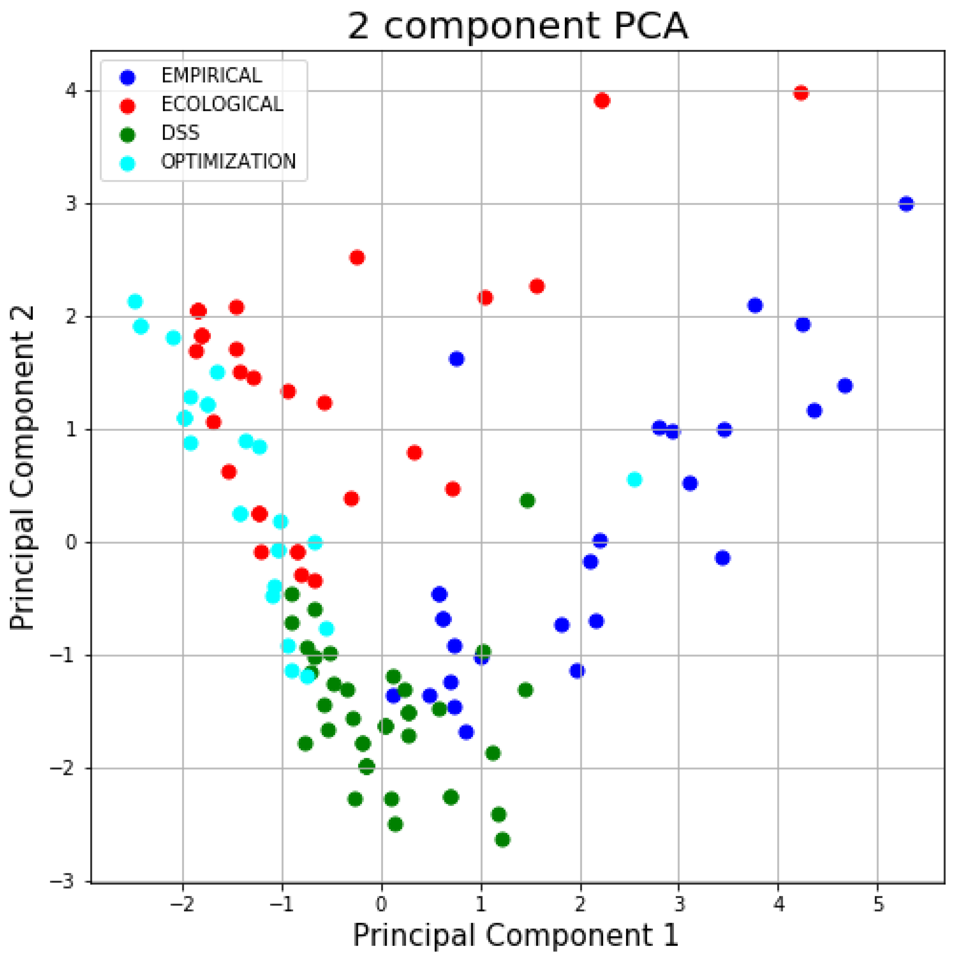
3.2. Development of Commonly Occurring “Types” of Spatial GSI Research

Once all the papers had been coded, we conducted a k-means nearest neighbor cluster analysis to understand commonly occurring combinations of motivations, assumptions, and approaches in spatial GSI research, as our RQ1 and RQ2 propose. K-means cluster analysis is an unsupervised machine learning algorithm that can be used to organize variability within and between subgroups in a population. Clusters are formed iteratively around centroids within a multidimensional space by minimizing the distances between each observation and the centroid of its closest group and maximizing the distances between groups. The results of a k-means cluster analysis are therefore very dependent on the choice of the number of groups (centroids). To determine the ideal number of clusters within the 127 papers reviewed, we used the “elbow method”, which identifies the number of clusters that results in the largest reduction in the within-cluster sum of squared distances to the centroids. Beyond this number of clusters, there is a diminishing return of including more clusters, which could result in identifying overly specific clusters that are not generalizable.

3.3. Interviews of Researchers

After the literature review and the development of “types”, we selected and conducted semi-structured interviews with a sample of authors of papers included in our literature review to investigate possible solutions to RQ3. Authors were selected to participate in the semi-structured interviews in English based on our classification of the “types” of their studies and sampling to achieve a diverse representation of authors’ departmental affiliations. The purpose of the interviews was to evaluate how researchers with different disciplinary backgrounds perceived the most important theoretical knowledge underlying their research and the most important unanswered questions about spatial GSI.
Most of the interviews were recorded and transcribed with the interviewees’ permission. In cases where the interviewee did not wish to be recorded, we made notes of the main points the interviewees mentioned. Interviews were limited to 30 min, and the interview protocol can be accessed in the Supplementary Information. We then analyzed the transcribed interviews for major themes related to what kinds of knowledge are necessary to conduct cutting-edge spatial GSI research, and the influence of academic discipline on how research is defined.

4. Results

Among the 127 papers included in the review, the top three countries of first authors’ affiliations were the United States (75), China (25), and Australia (15), and approximately 24 were from various European countries. The number of articles included in our literature review, 127, is appropriate given our search and exclusion criteria, as well as our analysis method (cluster analyses), for which it makes sense to have at least 10 observations per anticipated cluster [74].

4.1. Examples of “Types” of Spatial GSI Research

The cluster analysis revealed four “types” of spatial GSI research in our set of 127 reviewed papers. We assigned labels that capture the principal characteristics of each cluster. Cluster 1 (EMPIRICAL) was characterized by a motivation to untangle confounding factors in GSI performance using empirical data and statistical models. Cluster 2 (ECOLOGICAL) was characterized by a broader consideration of natural functions, such as stream baseflow or ecological function (in addition to drainage infrastructure function), and the use of dynamic models to evaluate the effects of various influences on system performance. Cluster 3 (Decision Support Systems (DSS)) was motivated by decision support and tended to consider broader criteria, often through multicriteria decision analysis methods. Cluster 4 (OPTIMIZATION) used simplified or “static” physical models (often coefficient-based) along with economic criteria to perform optimization studies. Because the clustering algorithm was performed on the 15 codes assigned to 15 sub-categories for each paper included in the review, the principal characteristics of each cluster varied (the clustering was not solely based on the “approach” of the study, for example, nor was it solely based on “motivation” nor “assumed components”). Therefore, the labels we assigned each cluster reflected the characteristics that most strongly dominated each cluster, whether they be motivation, assumed components, or approach. Figure 1 shows a visualization of the clusters formed. Because clustering took place on a 15-dimensional space (the coded attributes), in order to visualize the clusters, we used principal component analysis (PCA) to project the 15 dimensions of each paper included in the study onto a two-dimensional space. Note that because a projection has occurred, some variation in the original data may not be captured by the PCA, and points that appear far from cluster centers in the two-dimensional projection may not in actuality be far in the original 15-dimension space.
Table 2 shows the percentage of papers in each cluster by the academic discipline category of the first authors. A table showing the resulting cluster assignment for each paper included in the review is provided in the Table S2.
The results show that the distributions among clusters for first authors in engineering and natural science are similar. However, social science is very different, with many more social science studies in Cluster 3 (DSS), and fewer in Cluster 4 (OPTIMIZATION) and Cluster 2 (ECOLOGICAL).
Below, we provide illustrative descriptions of the studies that were most representative of each cluster. Representativeness was operationalized by calculating the Euclidean distance of each study (based on assigned codes) and the centroids of each cluster that resulted from the cluster analysis. In cluster analyses, studies that have the least distance to a cluster’s centroid are the most similar to that cluster; clusters that are further from a cluster’s centroid are the most dissimilar to that cluster.

4.1.1. EMPIRICAL Type

The first type of paper evaluated the effectiveness of GSI under various conditions using empirical, or field-collected, data. The motivation for such research was often to untangle, isolate, or identify interacting factors influencing an observed phenomenon related to GSI. Empirical models often used statistical analyses or techniques to isolate causality, including time-series analysis, comparisons of means, and regression analyses to break down the conflated factors.
One of the most representative studies of this type (located closest to the cluster’s centroid) was Kavehei et al., 2019 [75]. In this study, the authors investigated carbon accumulation patterns in a bioretention facility. The motivation of the study emphasized the importance of bioretention basins in GSI designs and the significance of the functionality of carbon in ecosystem cycles, and then pointed out that the carbon sequestration in GSI-related bioretention soil was not well understood from previous research. The authors then collected empirical soil data from over 25 subtropical bioretention basins in Australia over a 13-year chronosequence and studied the variance of carbon content by time, space, and depth. ANOVA tests were applied to test carbon sequestration levels among soils in different conditions; finally, regression analysis was performed to assess the relative impacts of various spatio-temporal factors on changes in soil texture, especially the carbon.
Another representative study by Monrabal-Martinez, Meyn, and Muthanna (2019) [76] studied the characteristics of metal fractions and particle-size distributions in an urban area with a cold coastal climate to better understand sustainable urban drainage systems (SUDS) as an overall system. Like Kavehei et al., this study also relied on collecting spatial samples of empirical data and found that suspended and dissolved solids increased at different levels during salting periods. Again similar to Kavahei et al., it used statistical analyses (Spearman correlation) and produced distribution histograms and box plots to present evidence.
Carson et al., 2013 [77], exhibited a similar research approach. In this study, the researchers monitored three green roofs in New York City and observed that the difference in the percent of rainfall attenuation levels is negatively correlated to the total rainfall. They then developed an empirical model called the characteristic runoff equation (CRE) using the historic rainfall data to project the rainfall retention for the aforementioned locations. By comparing the difference between the monitoring data and modeled data, the study identifies abnormally large rainfall events as the reason for model errors, concluding that using multi-year retention data for the CRE model could record a more accurate estimate for green roofs.

4.1.2. ECOLOGICAL Type

The second type of paper utilized dynamic models to simulate ecological phenomena that were more likely to include components outside of engineered GSI facilities, such as streamflow or groundwater. Many of these papers conducted sensitivity analyses to evaluate which model parameters were particularly influential on the model’s output. This was sometimes conducted as a formal sensitivity analysis but was also performed by comparing output between policy or practical consideration-driven scenario designs. Physics-based or dynamic rules-based models were commonly used by GSI researchers in this type of study.
Krebs et al. (2014) and Lee, Nietch, and Panguluri (2018) [78,79] are two of the most typical (closest to cluster’s centroid) publications that used dynamic models to compare scenarios and parameter sensitivity. Interestingly, both studies’ motivations included pointing out that many models commonly used in GSI research, such as the Storm Water Management Model (SWMM) developed by the U.S. Environmental Protection Agency (USEPA), are often not able to represent key ecological processes. Processes such as decentralized/dispersed depression storage and infiltration were perceived as important processes for low-impact development (LID) that could have large impacts on how effectiveness is evaluated.
Lee and colleagues assumed that the distinction of directly connected impervious surfaces from total impervious areas would have different performances during rain and drainage events, and such separation of classifications of subcatchements would improve the representation of modeled runoff processes. To verify the hypothesis, they used SWMM to simulate the dynamic performance of runoff discharge from six different urban spaces to a single inlet under 8–24 h synthetic storms. The results show that the developed SWMM model calibrated by adjusting parameters per land cover component, instead of per subcatchment, could provide better simulation results for large-scale watersheds. The authors suggested that this finding might be helpful for green stormwater infrastructure modeling and engineering.
Similarly, Krebs et al., 2014 [78], conducted a sensitivity analysis by using different calibration models for SWMM parameterizations on three catchments. The results demonstrate how the limitations on large-scale modeling could affect its results—high-resolution surface representation reduced the number of calibration parameters during the modeling process.

4.1.3. DSS Type

The third type of paper in our analysis was characterized by a motivation to provide support for decision makers evaluating multiple aspects of GSI, and often used multi-criteria decision analysis (MCDA). Decision support papers demonstrate the development of tools to support stakeholder decision making. MCDA was the most prominent model used in GSI papers that aimed to provide decision support. In these studies, authors selected criteria perceived as influential to the local natural and built environment, then assigned weights to each criterion. Among the studies included in our review, B. Li et al., 2019 [80], was one of the most representative of this type. In their paper, the authors developed an MCDA model called Environmental Risk Assessment (ERA) to specifically assess land use and identify parcels that are suitable for sustainable land use planning, which they viewed as an essential part of building a healthy and resilient urban ecosystem. The authors defined the function of green infrastructure as “reduc[ing] inundation, control[ling] nonpoint source pollution, and enhanc[ing] the landscape”. The ERA assembled and balanced the various criteria based on weights and scores through the analytic hierarchical process, informing outcomes that addressed the multifunctionality of the GSI. The ERA model they used included criteria such as topography, hydrology, ecosystem, land use, and traffic. The different weights were then used to compute a risk index across a landscape and produce a spatial risk map. The authors applied the ERA model to an environmentally sensitive area in Shenzhen, China, and prioritized high-risk urban areas for GSI implementation. In contrast to the representative studies in the previous cluster, Krebs et al., 2014, and Lee et al., 2018 [78,80], who focused on evaluating the specifics of processes represented within hydrological models, this paper paired MCDA methods with broader assumptions about which criteria would be relevant when defining and evaluating a spatial GSI network.
Another representative study of this type by Gruwald, Heusinger, and Weber (2017) [81] also illustrates the use of broader criteria in evaluating spatial GSI. The authors developed a DSS with criteria including elevation, land use, building ground plans, traffic counts, and climate function maps to calculate green roof potential area (GPRA) and applied it in Braunschweig, Germany.

4.1.4. OPTIMIZATION Type

Compared to the ECOLOGICAL type, which tended to use dynamic simulation models, the fourth type uses simpler, coefficient-based models in order to optimize multiple factors that might be considered in the GSI implementation processes. Studies of this type are also distinct from the DSS type, in that the DSS type of study tended to focus on the process of weighting criteria as part of the decision support, whereas the OPTIMIZATION type studies were more likely to frame their studies as “finding” an optimal solution. Many scholars acknowledge that the cost-effectiveness of GSI is one of the major concerns for GSI adoption. Thus, publications of the OPTIMIZATION type tended to incorporate cost/economic factors alongside measures of effectiveness as their major criteria considered. By setting optimization as the motivation for the study, these papers aim to find an efficient outcome given resource constraints related to the financing of GSI. Static, usually coefficient-based models were utilized as a common approach to operationalizing “effectiveness” within the optimization.
For example, in Xu et al., 2019 [82], the authors developed a novel optimization method on the existing adaptation pathway (AP) approach called the marginal cost-based greedy strategy (MCGS) to overcome the uncertainty of climate change, and to continually secure dynamically robust and cost-effective planning for GSI. By applying the AP with MCGS optimizations and comparing it with the existing genetic algorithm optimization in Suzhou, a pioneering sponge city in China, the authors showed that their method could save 1–60% in costs over the lifecycle of the GSI network compared to the implementation optimized by the existing genetic algorithm (GA). Additionally, the computational efficiency of MCGS was over 13 times faster than the GA.
In another example, Yazdi and Khazaei (2019) [83] tested the harmony search algorithm on the SWMM model in Tehran, Iran, to find the optimal place and size of online/offline detention ponds in a GSI network that would maximize the effectiveness of urban flood attenuation. Like Xu et al. [82], the authors also included cost as a significant part of the harmony search algorithm they developed. Giacomoni (2015) [84] also developed a multi-objective evolutionary algorithm (MOEA) to optimally site GSI so that hydrological effectiveness is maximized. Similarly, costs in association with peak flow and hydrologic footprint residence were used as metrics within the MOEA.

4.1.5. Interdisciplinary Spatial GSI Studies

Similar to how the cluster analysis allowed us to identify the studies that were most representative of each cluster (closest to cluster centroids), we also were able to identify the studies that had the shortest distances to every cluster centroid. We interpreted these studies to be the most interdisciplinary spatial GSI articles. These studies tended to not fit squarely into the k-means clustering results, and were often classified into different clusters when the k-means clustering algorithm was performed under different random seed starting conditions. Here, we present the most interdisciplinary studies by motivation, aspects of green infrastructure considered, and methodological approaches.
Dawson, Vercruysse, and Wright (2020) [85] developed a spatial framework that combined hydrodynamic modeling with other spatial information about the infrastructure network. The development of the framework was motivated by decision support and the optimization of the spatial network, as well as by evaluating the sensitivity of various parameters. Similarly, considerations of multiple and divergent aspects of green infrastructure were especially salient in Meerow (2019) [86], who developed a spatial planning model to evaluate synergies and tradeoffs in green infrastructure networks. In that study, the authors consider physical infrastructure, natural ecological function, equity, process representation in decision making, and economic factors. Another example of an interdisciplinary spatial GSI study was Kuller et al., 2017 [87], which included several methodological approaches. This was a synthesis study that identified how site selection studies for GI are focused either on finding places that need GI or finding opportunities to place GI, but not both. The authors illustrate how an overarching framework requires a greater variety of methodological tools.

4.2. Interview Findings

We conducted interviews with nine first authors selected from the studies included in our literature review. Of those interviewed, eight of the researchers were based in the U.S., and one in Europe. In the interviews, respondents were able to provide much more detail in describing their expertise areas.
Table 3 shows the terms researchers used to describe their own subject area expertise. While researchers in all three discipline categories stated expertise in “green infrastructure”, descriptions of expertise among the social scientists tended to be broader, including areas such as “policy and planning”, “spatial analysis”, and “coupled human and natural systems”. Potential linkages between the discipline categories also emerged. For example, social science researchers’ expertise and engineering researchers’ expertise overlapped in the area of “sustainability”, and engineering researchers’ expertise and natural science researchers’ expertise overlapped in the area of “urban stormwater management”. However, several topics or fields that researchers used to describe their expertise could be considered multi- or interdisciplinary. Some fields such as urban planning and urban geography are established as interdisciplinary. In fact, four of the researchers interviewed explicitly described themselves as “interdisciplinary researchers”.
In response to the question about what researchers believed to be the most important outstanding questions in spatial GSI research, the most frequently mentioned topic was addressing the question of “scaling up” or the implementation of GSI (mentioned by five researchers: two social scientists and three engineers) as a spatial network. The need to scale up was primarily mentioned with respect to regulatory obligations around drainage infrastructure (all nine interviewees mentioned this). One researcher (in the engineering discipline category) emphasized the importance of the stormwater context in the United States as follows:
“There is a lot of interdisciplinary green infrastructure work that doesn’t consider the engineering and urban design aspect of it and I feel like that work misses an opportunity, especially in the United States because funding for green infrastructure in the US is associated with its role in managing stormwater. There’s a lot of green infrastructure research that talks about green infrastructure in an abstract way independent of its role in stormwater management, and I feel like that research is limited in its potential for transforming green infrastructure because they’re not understanding the processes that are leading to billion-dollar investments in cities.”
However, all nine interviewees also mentioned the importance of accounting for physical functions other than stormwater management. Quantifying and/or accounting for multiple benefits of green infrastructure (beyond stormwater management) was mentioned by four researchers (two social scientists, two engineers). Several mentioned that a certain maturity in understanding the physical function of stormwater benefits and hydrologic benefits has already been reached over the past ten years, but that more is needed for other co-benefits:
“We have a reasonably good understanding of the stormwater benefits, hydrologic benefits of green infrastructure. I think obviously there is more that we could learn. And I think more consistent modeling of performance on hydrologic elements is definitely needed. But I think where we really need more work is an understanding of how we can really achieve these multiple co-benefits. When do we see those benefits? When do we not? And that includes more of these cultural ecosystem services and more social benefits.”
Another researcher mentioned the dilemma of increased attention to co-benefits, with relatively superficial means of systematically and proactively planning for those co-benefits.
“We do not yet really have tools and concepts or principles to design these systems to deliver these multifunctional benefits… It runs the risk of people getting a bad impression of these systems if they don’t work. It runs the risk of over investment where it becomes just yet another asset to manage or another issue to deal with, rather than what is actually a strategic, planned solution.”
Several interviewees pointed out that green infrastructure is primarily driven by the singular rationale of stormwater, despite the existence and acknowledgment of other rationales. This, coupled with the lack of a strategic approach to the holistic benefit of green infrastructure in cities, has resulted in an opportunistic rather than a systematic approach to implementation, which is still a major challenge in GSI implementation. Others mentioned that social science methods such as resident surveys and interviews are critical to understanding how GSI may be accepted by residents in cities. Both these gaps were attributed in part to the superficiality of interdisciplinary research:
“If we take the initial vision of trying to build multi-functional infrastructure that can deliver sustainable cities, we have to take an interdisciplinary approach. [We] talk about biodiversity, health, and heat islands. But … the interdisciplinarity of it, in my opinion, is not truly interdisciplinary. If I search for a bunch of papers that use multi-criteria decision analysis and all these spatial tools to figure out where’s the best place to put a green infrastructure, what I end up seeing over and over again is the use of proxy indicators, with little regard for understanding the underlying dynamics of why there’s an urban heat island in these locations, why there’s biodiversity loss here…”
One researcher mentioned how training in an inherently interdisciplinary discipline—geography—prepared her to understand how to integrate across methods and approaches. Another mentioned that identifying certain theories could help bridge more deeply across methods and disciplines:
“You could map out [different kinds of] spatial networks. You could map out how water flows, you can map out how species move, and you can map out the transport network for example, [or] energy balance modeling [and]…species distribution models… social networks … how the urban water cycle behaves… [then] use those within network theory to identify solutions. These need to be from datasets that are derived from first principles or from rigorously tested methods, [rather than simple proxies].”
Other researchers echoed the need to facilitate deeper interdisciplinarity and strategies for achieving this. One described how she had to learn how to think more broadly across a range of issues, while her collaborator (of a different discipline) had to learn how to compartmentalize components of the problem more effectively before they could work together. Two interviewees, both trained as engineers, went further, taking it upon themselves to learn the methods typically associated with social sciences.
Several researchers mentioned challenges with assumed knowledge and understanding the vocabularies, jargon, and even written language organization of other disciplines:
“Having enough of just a basic understanding of the science there so that you can communicate is important. If you can’t even find a common language to discuss these ideas, it’s hard to get anywhere so I think there has to be some effort from every side in terms of developing that basic set of language, or that set of concepts that you all can agree on and focus on.”
One engineer mentioned initially not understanding why social scientists put such emphasis on conceptual framing, realizing later that framing added context and meaning, while one social scientist commented that despite working on interdisciplinary projects: “I don’t feel like we ever felt like we got on the same page with the engineers, about what it meant to be engaged with community or what it meant to design something that was community-focused. I think there was a disciplinary thing but there was also a definite power differential there”. These examples emphasized the importance of a transdisciplinary orientation, including openness to learning and changing one’s own perspective, and being aware of one’s own positionality in an interdisciplinary project [88].
Lastly, through their responses to the interview questions, the interviewees generated lists of important skills, theories, and background knowledge they believed necessary for conducting cutting-edge research on GSI. This list is shown, organized by broad academic discipline category, in Table 4. Unsurprisingly, given the focus on the spatiality of GSI, understanding geographic information systems (GIS) is listed as a necessary skill across all the discipline categories. Theories and knowledge areas generated by the interviewees also included cross-disciplinary topics; for example, understanding equity and justice, human factors of decision making, and environmental justice appear in all three discipline categories.

5. Discussion and Conclusions

5.1. Main Findings and Contributions

In this study, we set out to understand the types of interdisciplinarity in spatial GSI research by proposing three research questions. In response to RQ1, we reviewed 127 articles to develop commonly occurring “types” of studies, including stated motivations, assumptions, and methodological approaches. We then selected nine authors from the reviewed literature to provide more context on the state of interdisciplinarity in spatial GSI research, challenges, and opportunity areas.
Addressing RQ2, we found four distinguishable “types” of spatial GSI research: (1) those that are motivated by untangling confounding factors in GSI performance and use empirical models; (2) those that use dynamic models to evaluate various influences on system performance as a broader ecological system; (3) those that are motivated by decision support and are likely to use multicriteria decision analysis methods; and (4) those that are motivated to “optimize” spatial networks, usually using criteria of costs and performance. Studies that were not clearly categorized by the clustering algorithm we used tended to include a broader range of motivations, system components, and methodological approaches than studies that were clearly classified into the above types. We noticed that the distributions of study types were more similar between first authors from engineering and natural science disciplines, while the distribution of types of papers with first authors from social science disciplines tended to emphasize decision support and multi-criteria decision analysis much more frequently.
Despite the separation of these clusters and the correlations with first author disciplines, in our in-depth interviews with researchers, we found that all interviewees had engaged in and recognized the importance of deeper interdisciplinary approaches in moving GSI research forward. The researchers also acknowledged the difficulty of interdisciplinary research, including the necessary investments in learning theories and methods of other disciplines and fields in order to effectively communicate with collaborators, and the need to move beyond superficial proxy-like representations of various system components towards first principles or science-based process representations. It is possible that the researchers may not be aware of the significance of systems and interdisciplinary thinking as important approaches for GSI research, which addresses RQ3.
Furthermore, although methods such as multicriteria decision analysis have the potential to integrate more system components into decision criteria, the interviews revealed the perceived shortcomings of the approach, including the superficiality of proxy indicators, the reduction in dynamic spatial processes that occur within the urban environments in which GSI is being implemented, and generally, a lack of deeper cross-disciplinary integration and communication that would lead to true inter- or transdisciplinary research.

5.2. Limitations

There are several limitations of our research. Firstly, limiting our literature review searches and interviews to green infrastructure for stormwater management (GSI) likely biases the studies to include those that are more likely to position their research in relation to the technical aspects of stormwater and urban drainage management infrastructure. In Table 4, approaches and strategies required for interdisciplinary GSI research, such as systems thinking and interdisciplinary thinking, were not mentioned by the interviewees, possibly indicating that the researchers we selected are not aware of the significance of system/interdisciplinary thinking as important approaches for conducting interdisciplinary GSI research. While more cities are increasingly viewing such systems as socio-ecological technical systems, this is a relatively recent shift in the approach to infrastructure planning [10,89], and there are many more studies that address urban ecology, green/open space, and urban public services more generally that could be considered “green infrastructure” and that may have increased the representation of social science approaches.
Secondly, we used the departmental affiliation of the first author of each paper as a proxy for their disciplinary epistemological foundation. However, in many cases, research teams comprised multiple academic disciplines. The team’s research process may have included meaningful inter- or transdisciplinary collaboration and multiple-loop learning but may simply not have been explicitly stated in the final publications, which usually need to be tailored to (disciplinary-specific) journal standards. A bibliometric analysis of citations in the papers included could help represent how cross-disciplinary knowledge is being integrated in different kinds of journals.
Moreover, the inclusion of English-only articles may also result in the overrepresentation of GSI papers from English-speaking countries. As our results show, the majority of the papers in the literature review are from the U.S. Thus, the findings of the paper may be most applicable to North America and Europe.
Lastly, while interviews were helpful in elucidating the nature of cross-disciplinary research and spatial GSI, it was difficult for some interviewees to answer questions about what research questions about GSI and what theories or kinds of literature they believed to be “most important”. We believe this in part to be because many of our interviewees had collaborated in multidisciplinary groups where they experienced how discipline shaped what knowledge was brought forward and the priorities of different researchers, making it difficult to answer, even from their own perspective, what they believed to be “most important”.

5.3. Suggestions for Future Research

The gaps in interdisciplinary research found in this study could be addressed through an explicit process of collaborative problem-framing in cross-disciplinary teams that includes more in-depth discussions about researchers’ motivations for research questions, the reasons for which some system components are considered/represented and others are not, and the methodological approaches that allow researchers to engage in knowledge creation.
In socio-ecological systems research, the shifts in problem-framing that occur during transdisciplinary research have been conceptualized as a “multiple-loop” social learning process, in which participants develop the awareness of others’ different goals and perspectives and engage together in problem identification through exercises that elicit different mental models of the same socio-ecological system [90]. The purpose of eliciting such models is to speed up and formalize the processes of learning about cross-discipline collaborators’ epistemological foundations, which several of our interviewees revealed were often slow processes that involved breaking down stereotypes and caricatures of other disciplinary approaches. In fact, these strategies are common in socio-ecological systems management and ecosystems services literatures; see, for example, Pennington et al., 2021, and Hedelin et al., 2021 [91,92].
In the introduction of this paper, we touched on tools that are often used to help researchers communicate implicitly held assumptions about relevant system components and causality to potential collaborators with different backgrounds. These tools included mind-mapping, concept mapping, and collaborative conceptual mapping. Participatory modeling is one approach to transdisciplinary collaboration that has been applied to the adaptive management of socio-ecological systems. Unlike the qualitative approaches mentioned earlier in the paper, participatory modeling spans a range of quantitative and qualitative methods at varying levels of formalization [93]. The purpose of all the methods is to intentionally provide opportunities to integrate the knowledge, values, and perspectives of experts and stakeholders. In addition, the concept may be extended to quantitative modeling through computer simulation. This makes participatory modeling particularly flexible for bridging cross-disciplinary knowledge, ranging from problem conceptualization, assumed system components, and methodological approaches, the three categories of epistemological approach addressed in this paper. There are many examples of the process of co-creating model representations of socio-ecological systems [91]. These examples illustrate how both conceptual and computational models can be used to facilitate in-depth transdisciplinary discussions about appropriate resolutions, processes/dynamics that need to be represented, important system outputs, and system components [94,95].
Although there are numerous applications of the participatory modeling approaches to transdisciplinary research in water resources [96,97,98], our literature review did not reveal any examples of these approaches applied to facilitate cross-disciplinary research about spatial GSI implementation. While many participatory modeling techniques have focused on the involvement of non-expert stakeholders, tools commonly used in participatory modeling processes, such as fuzzy cognitive mapping, causal loop diagramming, and participatory GIS, may also help academic researchers find opportunities for deeper integration of knowledge [93,99]. Such techniques have been used in the past in advancing transdisciplinary research in other systems that may include meeting multiple potentially competing objectives that require cross-disciplinary collaboration, such as energy systems transitions planning and planning the provision of ecosystem services [100,101]. This suggests that participatory modeling techniques in spatial GSI implementation research could be a promising area for further development.

Supplementary Materials

The following supporting information can be downloaded at: https://www.mdpi.com/article/10.3390/su14031198/s1, Table S1: Disciplines; Table S2: Paper clusters.

Funding

The Virginia Tech Open Access Subvention Fund provided financial support for the publication of this article. Lechuan Huang was supported by a research assistantship from the School of Public and International Affairs at Virginia Tech.

Institutional Review Board Statement

The Virginia Tech Human Research Protection Program (HRPP) determined that this protocol meets the criteria for exemption from IRB review under 45 CFR 46.104(d) category (ies) 2(ii). The IRB Number of the review was 21-370.

Informed Consent Statement

Informed consent was obtained from all subjects involved in the study.

Data Availability Statement

Data used in this study may be requested from the corresponding author.

Conflicts of Interest

The authors declare no conflict of interest.

References

  1. Ashley, R.M.; Gersonius, B.; Digman, C.; Horton, B.; Bacchin, T.; Smith, B.; Shaffer, P.; Baylis, A. Demonstrating and Monetizing the Multiple Benefits from Using SuDS. J. Sustain. Water Built Environ. 2018, 4, 05017008. [Google Scholar] [CrossRef]
  2. Andrew, R.F. Spatial Evaluation of Multiple Benefits to Encourage Multi-Functional Design of Sustainable Drainage in Blue-Green Cities. Water 2017, 9, 953. [Google Scholar] [CrossRef] [Green Version]
  3. Fletcher, T.D.; Shuster, W.; Hunt, W.F.; Ashley, R.; Butler, D.; Arthur, S.; Trowsdale, S.; Barraud, S.; Semadeni-Davies, A.; Bertrand-Krajewski, J.-L.; et al. SUDS, LID, BMPs, WSUD and More—The Evolution and Application of Terminology Surrounding Urban Drainage. Urban Water J. 2014, 12, 525–542. [Google Scholar] [CrossRef]
  4. Tzoulas, K.; Korpela, K.; Venn, S.; Yli-Pelkonen, V.; Kaźmierczak, A.; Niemela, J.; James, P. Promoting Ecosystem and Human Health in Urban Areas Using Green Infrastructure: A Literature Review. Landsc. Urban Plan. 2007, 81, 167–178. [Google Scholar] [CrossRef] [Green Version]
  5. BenDor, T.K.; Shandas, V.; Miles, B.; Belt, K.; Olander, L. Ecosystem Services and U.S. Stormwater Planning: An Approach for Improving Urban Stormwater Decisions. Environ. Sci. Policy 2018, 88, 92–103. [Google Scholar] [CrossRef] [Green Version]
  6. Christman, Z.; Meenar, M.; Mandarano, L.; Hearing, K. Prioritizing Suitable Locations for Green Stormwater Infrastructure Based on Social Factors in Philadelphia. Land 2018, 7, 145. [Google Scholar] [CrossRef] [Green Version]
  7. Matsler, A.M.; Grabowski, Z.J.; Elder, A.D. The Multifaceted Geographies of Green Infrastructure Policy and Planning: Socio-Environmental Dreams, Nightmares, and Amnesia. J. Environ. Policy Plan. 2021, 23, 559–564. [Google Scholar] [CrossRef]
  8. Mell, I.; Clement, S. Progressing Green Infrastructure Planning: Understanding Its Scalar, Temporal, Geo-Spatial and Disciplinary Evolution. Impact Assess. Proj. Apprais. 2020, 38, 449–463. [Google Scholar] [CrossRef]
  9. Matsler, A.M. Making ‘Green’ Fit in a ‘Grey’ Accounting System: The Institutional Knowledge System Challenges of Valuing Urban Nature as Infrastructural Assets. Environ. Sci. Policy 2019, 99, 160–168. [Google Scholar] [CrossRef]
  10. Pincetl, S. From the Sanitary City to the Sustainable City: Challenges to Institutionalising Biogenic (Nature’s Services) Infrastructure. Local Environ. 2010, 15, 43–58. [Google Scholar] [CrossRef]
  11. Klein, J.T.; Misra, S.; Lotrecchiano, G.R. Introduction: Communication in Inter- and Trans-Disciplinary Teams. In Communication in Transdisciplinary Teams; Lotrecchiano, G.R., Misra, S., Eds.; Informing Science: Santa Rosa, CA, USA, 2020; pp. 1–18. ISBN 978-1-68110-052-4. [Google Scholar]
  12. Stokols, D.; Misra, S.; Moser, R.P.; Hall, K.L.; Taylor, B.K. The Ecology of Team Science: Understanding Contextual Influences on Transdisciplinary Collaboration. Am. J. Prev. Med. 2008, 35, S96–S115. [Google Scholar] [CrossRef] [PubMed]
  13. Badham. A Compendium of Modeling Techniques. Integr. Insights 2010, 12, 25. [Google Scholar]
  14. Petrie, H.G. Do You See What I See? The Epistemology of Interdisciplinary Inquiry. Educ. Res. 1976, 5, 9–15. [Google Scholar] [CrossRef]
  15. Mell, I.C. Can You Tell a Green Field from a Cold Steel Rail? Examining the “Green” of Green Infrastructure Development. Local Environ. 2013, 18, 152–166. [Google Scholar] [CrossRef]
  16. Matthews, T.; Lo, A.Y.; Byrne, J.A. Reconceptualizing Green Infrastructure for Climate Change Adaptation: Barriers to Adoption and Drivers for Uptake by Spatial Planners. Landsc. Urban Plan. 2015, 138, 155–163. [Google Scholar] [CrossRef]
  17. Matsler, A.M.; Meerow, S.; Mell, I.C.; Pavao-Zuckerman, M.A. A ‘Green’ Chameleon: Exploring the Many Disciplinary Definitions, Goals, and Forms of “Green Infrastructure”. Landsc. Urban Plan. 2021, 214, 104145. [Google Scholar] [CrossRef]
  18. Finewood, M.H. Green infrastructure, grey epistemologies, and the urban political ecology of Pittsburgh’s water governance. Antipode 2016, 48, 1000–1021. [Google Scholar] [CrossRef]
  19. US EPA. Managing Wet Weather with Green Infrastructure: Municipal Handbook Funding Options; National Service Center for Environmental Publications (NSCEP): Cincinnati, OH, USA, 2008.
  20. Emerson, C.; Welty, C.; Traver, R. Watershed-Scale Evaluation of a System of Storm Water Detention Basins. J. Hydrol. Eng. 2005, 10, 237–242. [Google Scholar] [CrossRef]
  21. Driscoll, C.T.; Eger, C.G.; Chandler, D.G.; Davidson, C.I.; Roodsari, B.K.; Flynn, C.D.; Lambert, K.F.; Bettez, N.D.; Groffman, P.M. Green Infrastructure: Lessons from Science and Practice; Science Policy Exchange: Syracuse, NY, USA, 2015; p. 32. [Google Scholar]
  22. Page, J.L.; Winston, R.J.; Mayes, D.B.; Perrin, C.; Hunt, W.F., III. Retrofitting with Innovative Stormwater Control Measures: Hydrologic Mitigation of Impervious Cover in the Municipal Right-of-Way. J. Hydrol. 2015, 527, 923–932. [Google Scholar] [CrossRef]
  23. Li, H.; Sharkey, L.J.; Hunt, W.F.; Davis, A.P. Mitigation of Impervious Surface Hydrology Using Bioretention in North Carolina and Maryland. J. Hydrol. Eng. 2009, 14, 407–415. [Google Scholar] [CrossRef] [Green Version]
  24. Fanelli, R.; Prestegaard, K.; Palmer, M. Evaluation of Infiltration-based Stormwater Management to Restore Hydrological Processes in Urban Headwater Streams. Hydrol. Process. 2017, 31, 3306–3319. [Google Scholar] [CrossRef]
  25. Loperfido, J.V.; Noe, G.B.; Jarnagin, S.T.; Hogan, D.M. Effects of Distributed and Centralized Stormwater Best Management Practices and Land Cover on Urban Stream Hydrology at the Catchment Scale. J. Hydrol. 2014, 519, 2584–2595. [Google Scholar] [CrossRef]
  26. Shuster, W.D.; Rhea, L. Catchment-Scale Hydrologic Implications of Parcel-Level Stormwater Management (Ohio USA). J. Hydrol. 2013, 485, 177–187. [Google Scholar] [CrossRef]
  27. Hogan, D.M.; Jarnagin, S.T.; Loperfido, J.V.; Van Ness, K. Mitigating the Effects of Landscape Development on Streams in Urbanizing Watersheds. J. Am. Water Resour. Assoc. 2014, 50, 163–178. [Google Scholar] [CrossRef]
  28. Bhaskar, A.S.; Hogan, D.M.; Archfield, S.A. Urban Base Flow with Low Impact Development. Hydrol. Process. 2016, 30, 3156–3171. [Google Scholar] [CrossRef] [Green Version]
  29. Jefferson, A.; Bhaskar, A.S.; Hopkins, K.G.; Fanelli, R.; Avellaneda, P.; McMillan, S.K. Stormwater Management Network Effectiveness and Implications for Urban Watershed Function: A Critical Review. Hydrol. Process. 2017, 31, 4056–4080. [Google Scholar] [CrossRef]
  30. Avellaneda, P.M.; Jefferson, A.J.; Grieser, J.M.; Bush, S.A. Simulation of the Cumulative Hydrological Response to Green Infrastructure. Water Resour. Res. 2017, 53, 3087–3101. [Google Scholar] [CrossRef]
  31. Endreny, T.; Collins, V. Implications of Bioretention Basin Spatial Arrangements on Stormwater Recharge and Groundwater Mounding. Ecol. Eng. 2009, 35, 670–677. [Google Scholar] [CrossRef]
  32. Lim, T.C.; Welty, C. Effects of Spatial Configuration of Imperviousness and Green Infrastructure Networks on Hydrologic Response in a Residential Sewershed. Water Resour. Res. 2017, 53, 8084–8104. [Google Scholar] [CrossRef]
  33. Bhaskar, A.; Welty, C.; Maxwell, R.M.; Miller, A.J. Untangling the Effects of Urban Development on Subsurface Storage in Baltimore. Water Resour. Res. 2015, 51, 1158–1181. [Google Scholar] [CrossRef]
  34. Voter, C.B.; Loheide, S.P. Urban Residential Surface and Subsurface Hydrology: Synergistic Effects of Low-Impact Features at the Parcel Scale. Water Resour. Res. 2018, 54, 8216–8233. [Google Scholar] [CrossRef]
  35. Vineyard, D.; Ingwersen, W.W.; Hawkins, T.R.; Xue, X.; Demeke, B.; Shuster, W. Comparing Green and Grey Infrastructure Using Life Cycle Cost and Environmental Impact: A Rain Garden Case Study in Cincinnati, OH. J. Am. Water Resour. Assoc. 2015, 51, 1342–1360. [Google Scholar] [CrossRef]
  36. Bianchini, F.; Hewage, K. Probabilistic Social Cost-Benefit Analysis for Green Roofs: A Lifecycle Approach. Build. Environ. 2012, 58, 152–162. [Google Scholar] [CrossRef]
  37. Wang, R.; Eckelman, M.J.; Zimmerman, J.B. Consequential Environmental and Economic Life Cycle Assessment of Green and Gray Stormwater Infrastructures for Combined Sewer Systems. Environ. Sci. Technol. 2013, 47, 11189–11198. [Google Scholar] [CrossRef] [PubMed]
  38. Troy, A.; Grove, J.M. Property Values, Parks, and Crime: A Hedonic Analysis in Baltimore, MD. Landsc. Urban Plan. 2008, 87, 233–245. [Google Scholar] [CrossRef]
  39. Bolitzer, B.; Netusil, N.R. The Impact of Open Spaces on Property Values in Portland, Oregon. J. Environ. Manag. 2000, 59, 185–193. [Google Scholar] [CrossRef]
  40. Netusil, N.R.; Levin, Z.; Shandas, V.; Hart, T. Valuing Green Infrastructure in Portland, Oregon. Landsc. Urban Plan. 2014, 124, 14–21. [Google Scholar] [CrossRef]
  41. Sohn, W.; Kim, H.W.; Kim, J.-H.; Li, M.-H. The Capitalized Amenity of Green Infrastructure in Single-Family Housing Values: An Application of the Spatial Hedonic Pricing Method. Urban For. Urban Green. 2020, 49, 126643. [Google Scholar] [CrossRef]
  42. Baptiste, A.K.; Foley, C.; Smardon, R. Understanding Urban Neighborhood Differences in Willingness to Implement Green Infrastructure Measures: A Case Study of Syracuse, NY. Landsc. Urban Plan. 2015, 136, 1–12. [Google Scholar] [CrossRef]
  43. Schifman, L.A.; Herrmann, D.L.; Shuster, W.D.; Ossola, A.; Garmestani, A.; Hopton, M.E. Situating Green Infrastructure in Context: A Framework for Adaptive Socio-Hydrology in Cities. Water Resour. Res. 2017, 53, 10139–10154. [Google Scholar] [CrossRef]
  44. Jessup, K.; Parker, S.S.; Randall, J.M.; Cohen, B.S.; Roderick-Jones, R.; Ganguly, S.; Sourial, J. Planting Stormwater Solutions: A Methodology for Siting Nature-Based Solutions for Pollution Capture, Habitat Enhancement, and Multiple Health Benefits. Urban For. Urban Green. 2021, 64, 127300. [Google Scholar] [CrossRef]
  45. Kondo, M.C.; Low, S.C.; Henning, J.; Branas, C.C. The Impact of Green Stormwater Infrastructure Installation on Surrounding Health and Safety. Am. J. Public Health 2015, 105, e114–e121. [Google Scholar] [CrossRef]
  46. Garvin, E.C.; Cannuscio, C.C.; Branas, C.C. Greening Vacant Lots to Reduce Violent Crime: A Randomised Controlled Trial. Inj. Prev. 2013, 19, 198–203. [Google Scholar] [CrossRef] [PubMed]
  47. Clark, C.; Busiek, B.; Adriaens, P. Quantifying Thermal Impacts of Green Infrastructure: Review and Gaps. Available online: https://www.ingentaconnect.com/content/wef/wefproc/2010/00002010/00000002/art00006 (accessed on 18 November 2018).
  48. Shashua-Bar, L.; Hoffman, M.E. Vegetation as a Climatic Component in the Design of an Urban Street: An Empirical Model for Predicting the Cooling Effect of Urban Green Areas with Trees. Energy Build. 2000, 31, 221–235. [Google Scholar] [CrossRef]
  49. Middel, A.; Selover, N.; Hagen, B.; Chhetri, N. Impact of Shade on Outdoor Thermal Comfort—A Seasonal Field Study in Tempe, Arizona. Int. J. Biometeorol. 2016, 60, 1849–1861. [Google Scholar] [CrossRef] [Green Version]
  50. Drake, L.; Lawson, L.J. Validating Verdancy or Vacancy? The Relationship of Community Gardens and Vacant Lands in the U.S. Cities 2014, 40, 133–142. [Google Scholar] [CrossRef]
  51. Morckel, V. Using Suitability Analysis to Select and Prioritize Naturalization Efforts in Legacy Cities: An Example from Flint, Michigan. Urban For. Urban Green. 2017, 27, 343–351. [Google Scholar] [CrossRef]
  52. Wolch, J.R.; Byrne, J.; Newell, J.P. Urban Green Space, Public Health, and Environmental Justice: The Challenge of Making Cities ‘Just Green Enough’. Landsc. Urban Plan. 2014, 125, 234–244. [Google Scholar] [CrossRef] [Green Version]
  53. Cousins, J.J.; Hill, D.T. Green Infrastructure, Stormwater, and the Financialization of Municipal Environmental Governance. J. Environ. Policy Plan. 2021, 23, 581–598. [Google Scholar] [CrossRef]
  54. Heck, S. Greening the Color Line: Historicizing Water Infrastructure Redevelopment and Environmental Justice in the St. Louis Metropolitan Region. J. Environ. Policy Plan. 2021, 23, 565–580. [Google Scholar] [CrossRef]
  55. Ando, A.W.; Freitas, L.P.C. Consumer Demand for Green Stormwater Management Technology in an Urban Setting: The Case of Chicago Rain Barrels. Water Resour. Res. 2011, 47, W12501. [Google Scholar] [CrossRef]
  56. Lim, T.C. An Empirical Study of Spatial-Temporal Growth Patterns of a Voluntary Residential Green Infrastructure Program. J. Environ. Plan. Manag. 2017, 61, 1363–1382. [Google Scholar] [CrossRef]
  57. Mandarano, L.; Meenar, M. Equitable Distribution of Green Stormwater Infrastructure: A Capacity-Based Framework for Implementation in Disadvantaged Communities. Local Environ. 2017, 22, 1338–1357. [Google Scholar] [CrossRef]
  58. Heckert, M.; Rosan, C.D. Developing a Green Infrastructure Equity Index to Promote Equity Planning. Urban For. Urban Green. 2016, 19, 263–270. [Google Scholar] [CrossRef]
  59. Hoover, F.-A.; Meerow, S.; Grabowski, Z.J.; McPhearson, T. Environmental Justice Implications of Siting Criteria in Urban Green Infrastructure Planning. J. Environ. Policy Plan. 2021, 23, 665–682. [Google Scholar] [CrossRef]
  60. Meerow, S.; Newell, J.P. Spatial Planning for Multifunctional Green Infrastructure: Growing Resilience in Detroit. Landsc. Urban Plan. 2017, 159, 62–75. [Google Scholar] [CrossRef]
  61. Coppola, E.; Rouphael, Y.; De Pascale, S.; Moccia, F.D.; Cirillo, C. Ameliorating a Complex Urban Ecosystem Through Instrumental Use of Softscape Buffers: Proposal for a Green Infrastructure Network in the Metropolitan Area of Naples. Front. Plant Sci. 2019, 10, 410. [Google Scholar] [CrossRef] [Green Version]
  62. Creswell, J.W. Educational Research: Planning, Conducting, and Evaluating Quantitative; Prentice Hall: Upper Saddle River, NJ, USA, 2002; p. 676. [Google Scholar]
  63. Creswell, J.W.; Klassen, A.C.; Plano Clark, V.L.; Smith, K.C. Best Practices for Mixed Methods Research in the Health Sciences; National Institutes of Health: Bethesda, MD, USA, 2013; pp. 541–545. [Google Scholar]
  64. Flick, U. (Ed.) The SAGE Handbook of Qualitative Data Analysis; Sage: Thousand Oaksm, MA, USA, 2013. [Google Scholar]
  65. Yu, Y.; Xu, H.; Wang, X.; Wen, J.; Du, S.; Zhang, M.; Ke, Q. Residents’ Willingness to Participate in Green Infrastructure: Spatial Differences and Influence Factors in Shanghai, China. Sustainability 2019, 11, 5396. [Google Scholar] [CrossRef] [Green Version]
  66. Meerow, S. The Politics of Multifunctional Green Infrastructure Planning in New York City. Cities 2020, 100, UNSP 102621. [Google Scholar] [CrossRef]
  67. Jia, Z.; Xu, C.; Luo, W. Optimizing Green Infrastructure Implementation with a Land Parcel-Based Credit Trading Approach on Different Spatial Scales. Water Resour. Manag. 2020, 34, 1709–1723. [Google Scholar] [CrossRef]
  68. Kazak, J.K.; Chruscinski, J.; Szewranski, S. The Development of a Novel Decision Support System for the Location of Green Infrastructure for Stormwater Management. Sustainability 2018, 10, 4388. [Google Scholar] [CrossRef] [Green Version]
  69. Lim, T.C.; Welty, C. Assessing Variability and Uncertainty in Green Infrastructure Planning Using a High-Resolution Surface-Subsurface Hydrological Model and Site-Monitored Flow Data. Front. Built Environ. 2018, 4, 71. [Google Scholar] [CrossRef]
  70. Bai, T.; Mayer, A.L.; Shuster, W.D.; Tian, G. The Hydrologic Role of Urban Green Space in Mitigating Flooding (Luohe, China). Sustainability 2018, 10, 3584. [Google Scholar] [CrossRef] [PubMed] [Green Version]
  71. Singh, A.; Sarma, A.K.; Hack, J. Cost-Effective Optimization of Nature-Based Solutions for Reducing Urban Floods Considering Limited Space Availability. Environ. Process.-Int. J. 2020, 7, 297–319. [Google Scholar] [CrossRef]
  72. Li, C.; Liu, M.; Hu, Y.; Shi, T.; Qu, X.; Walter, M.T. Effects of Urbanization on Direct Runoff Characteristics in Urban Functional Zones. Sci. Total Environ. 2018, 643, 301–311. [Google Scholar] [CrossRef]
  73. Elliott, A.; Trowsdale, S. A Review of Models for Low Impact Urban Stormwater Drainage. Environ. Model. Softw. 2007, 22, 394–405. [Google Scholar] [CrossRef]
  74. Qiu, W.; Harry, J. Generation of Random Clusters with Specified Degree of Separation. J. Classif. 2006, 23, 315–334. [Google Scholar] [CrossRef]
  75. Emad, K.; Jenkins, G.A.; Lemckert, C.; Adame, M.F. Carbon Stocks and Sequestration of Stormwater Bioretention/Biofiltration Basins. Ecol. Eng. 2019, 138, 227–236. [Google Scholar] [CrossRef]
  76. Monrabal-Martinez, C.; Meyn, T.; Muthanna, T.M. Characterization and Temporal Variation of Urban Runoff in a Cold Climate-Design Implications for SuDS. Urban Water J. 2019, 16, 451–459. [Google Scholar] [CrossRef]
  77. Carson, T.B.; Marasco, D.E.; Culligan, P.J.; McGillis, W.R. Hydrological Performance of Extensive Green Roofs in New York City: Observations and Multi-Year Modeling of Three Full-Scale Systems. Environ. Res. Lett. 2013, 8, 024036. [Google Scholar] [CrossRef]
  78. Krebs, G.; Kokkonen, T.; Valtanen, M.; Setala, H.; Koivusalo, H. Spatial Resolution Considerations for Urban Hydrological Modelling. J. Hydrol. 2014, 512, 482–497. [Google Scholar] [CrossRef]
  79. Lee, J.G.; Nietch, C.T.; Panguluri, S. Drainage Area Characterization for Evaluating Green Infrastructure Using the Storm Water Management Model. Hydrol. Earth Syst. Sci. 2018, 22, 2615–2635. [Google Scholar] [CrossRef] [Green Version]
  80. Li, B.; Dong, S.L.; Huang, Y.F.; Wang, G.Q. Development of a Heterogeneity Analysis Framework for Collaborative Sponge City Management. Water 2019, 11, 1995. [Google Scholar] [CrossRef] [Green Version]
  81. Gruwald, L.; Heusinger, J.; Weber, S. A GIS-Based Mapping Methodology of Urban Green Roof Ecosystem Services Applied to a Central European City. Urban For. Urban Green. 2017, 22, 54–63. [Google Scholar] [CrossRef]
  82. Xu, T.; Li, K.; Engel, B.A.; Jia, H.; Leng, L.; Sun, Z.; Yu, S.L. Optimal Adaptation Pathway for Sustainable Low Impact Development Planning under Deep Uncertainty of Climate Change: A Greedy Strategy. J. Environ. Manag. 2019, 248, UNSP 109280. [Google Scholar] [CrossRef]
  83. Yazdi, J.; Khazaei, P. Copula-Based Performance Assessment of Online and Offline Detention Ponds for Urban Stormwater Management. J. Hydrol. Eng. 2019, 24, 04019025. [Google Scholar] [CrossRef]
  84. Giacomoni, M.H. Low Impact Development Placement Investigation Using a Multi-Objective Evolutionary Optimization Algorithm. In Proceedings of the World Environmental and Water Resources Congress, Austin, TX, USA, 17–21 May 2015; pp. 344–348. [Google Scholar]
  85. Dawson, D.A.; Vercruysse, K.; Wright, N. A Spatial Framework to Explore Needs and Opportunities for Interoperable Urban Flood Management. Philos. Trans. R. Soc. A-Math. Phys. Eng. Sci. 2020, 378, 20190205. [Google Scholar] [CrossRef] [PubMed] [Green Version]
  86. Meerow, S. A Green Infrastructure Spatial Planning Model for Evaluating Ecosystem Service Tradeoffs and Synergies across Three Coastal Megacities. Environ. Res. Lett. 2019, 14, 125011. [Google Scholar] [CrossRef] [Green Version]
  87. Kuller, M.; Bach, P.M.; Ramirez-Lovering, D.; Deletic, A. Framing Water Sensitive Urban Design as Part of the Urban Form: A Critical Review of Tools for Best Planning Practice. Environ. Model. Softw. 2017, 96, 265–282. [Google Scholar] [CrossRef]
  88. Misra, S.; Stokols, D.; Cheng, L. The Transdisciplinary Orientation Scale: Factor Structure and Relation to the Integrative Quality and Scope of Scientific Publications. J. Transl. Med. Epidemiol. 2015, 3, 1042. [Google Scholar]
  89. Markolf, S.A.; Chester, M.V.; Eisenberg, D.A.; Iwaniec, D.M.; Davidson, C.I.; Zimmerman, R.; Miller, T.R.; Ruddell, B.L.; Chang, H. Interdependent Infrastructure as Linked Social, Ecological, and Technological Systems (SETSs) to Address Lock-in and Enhance Resilience. Earth’s Future 2018, 6, 1638–1659. [Google Scholar] [CrossRef] [Green Version]
  90. Pahl-Wostl, C.; Hare, M. Processes of Social Learning in Integrated Resources Management. J. Community Appl. Soc. Psychol. 2004, 14, 193–206. [Google Scholar] [CrossRef]
  91. Pennington, D.; Vincent, S.; Gosselin, D.; Thompson, K. Learning across disciplines in socio-environmental problem framing. Socio-Environ. Syst. Model. 2021, 3, 17895. [Google Scholar] [CrossRef]
  92. Hedelin, B.; Gray, S.; Woehlke, S.; BenDor, T.K.; Singer, A.; Jordan, R.; Zellner, M.; Giabbanelli, P.; Glynn, P.; Jenni, K.; et al. What’s Left before Participatory Modeling Can Fully Support Real-World Environmental Planning Processes: A Case Study Review. Environ. Model. Softw. 2021, 143, 105073. [Google Scholar] [CrossRef]
  93. Moallemi, E.A.; de Haan, F.J.; Hadjikakou, M.; Khatami, S.; Malekpour, S.; Smajgl, A.; Smith, M.S.; Voinov, A.; Bandari, R.; Lamichhane, P.; et al. Evaluating Participatory Modeling Methods for Co-Creating Pathways to Sustainability. Earth’s Future 2021, 9, e2020EF001843. [Google Scholar] [CrossRef]
  94. Voinov, A.; Bousquet, F. Modelling with Stakeholders. Environ. Model. Softw. 2010, 25, 1268–1281. [Google Scholar] [CrossRef]
  95. Cockerill, K.; Daniel, L.; Malczynski, L.; Tidwell, V. A Fresh Look at a Policy Sciences Methodology: Collaborative Modeling for More Effective Policy. Policy Sci. 2009, 42, 211. [Google Scholar] [CrossRef] [Green Version]
  96. Brown Gaddis, E.J.; Vladich, H.; Voinov, A. Participatory Modeling and the Dilemma of Diffuse Nitrogen Management in a Residential Watershed. Environ. Model. Softw. 2007, 22, 619–629. [Google Scholar] [CrossRef]
  97. White, D.D.; Wutich, A.; Larson, K.L.; Gober, P.; Lant, T.; Senneville, C. Credibility, Salience, and Legitimacy of Boundary Objects: Water Managers’ Assessment of a Simulation Model in an Immersive Decision Theater. Sci. Pub. Pol. 2010, 37, 219–232. [Google Scholar] [CrossRef]
  98. Smith, R.; Kasprzyk, J.; Dilling, L. Participatory Framework for Assessment and Improvement of Tools (ParFAIT): Increasing the Impact and Relevance of Water Management Decision Support Research. Environ. Model. Softw. 2017, 95, 432–446. [Google Scholar] [CrossRef]
  99. Gray, S.; Voinov, A.; Paolisso, M.; Jordan, R.; BenDor, T.; Bommel, P.; Glynn, P.; Hedelin, B.; Hubacek, K.; Introne, J.; et al. Purpose, Processes, Partnerships, and Products: Four Ps to Advance Participatory Socio-Environmental Modeling. Ecol. Appl. 2018, 28, 46–61. [Google Scholar] [CrossRef] [PubMed] [Green Version]
  100. Harrison, P.A.; Dunford, R.; Barton, D.N.; Kelemen, E.; Martín-López, B.; Norton, L.; Termansen, M.; Saarikoski, H.; Hendriks, K.; Gómez-Baggethun, E.; et al. Selecting Methods for Ecosystem Service Assessment: A Decision Tree Approach. Ecosyst. Serv. 2018, 29, 481–498. [Google Scholar] [CrossRef] [Green Version]
  101. Michas, S.; Stavrakas, V.; Papadelis, S.; Flamos, A. A Transdisciplinary Modeling Framework for the Participatory Design of Dynamic Adaptive Policy Pathways. Energy Policy 2020, 139, 111350. [Google Scholar] [CrossRef]
Figure 1. Illustration of the clusters formed from the cluster analysis, projected onto two-dimensional space for visualization purposes.
Sustainability 14 01198 g001
Table 1. Subcategories that emerged in research papers addressing spatial GSI questions.
Motivations for Spatial GI Research
NameDescriptionExample
Participatory processArticle mentions the objective of increasing participation in decision making processes. Emphasis placed on elevating voices/perspectives of marginalized people.[65,66]
Optimization/efficiencyArticle mentions optimization (or spatial location of GI, or amount of GI) to find an “efficient” outcome given scarce resources, as a purpose of the article.[67]
Complexity/emergent patterns/causalityArticle’s motivation is to untangle, isolate, or identify interacting factors influencing an observed phenomenon.[56]
Decision supportArticle demonstrates the development of tools, systems, etc., to support stakeholder decision making.[68]
Sensitivity and scenariosArticle’s purpose is to evaluate the “sensitivity” of a spatial process (assessing the level of variability between scenarios).[69]
Assumptions about what are Important Components of Spatial GSI Systems
Physical function of built infrastructureArticle addresses the performance of built infrastructure (for example, drainage infrastructure’s ability to prevent flooding, or prevention of combined sewer overflows) and water quality/quantity with respect to infrastructure.[70]
Physical function of natural processesArticle addresses the function of natural systems (for example, water quality/quantity with respect to natural hydrology, maintaining minimum baseflow or other stream metrics, biodiversity/habitat, groundwater recharge, urban air temperatures, etc.).[25]
Social equityArticle addresses the fair distribution of resources (for example, siting of green infrastructure in poor/underserved neighborhoods).[58]
Process/representationArticle addresses whether diverse voices are heard in decision making, or have access to resources.[58]
Economics/costs/financing/monetary policy incentivesArticle addresses capital costs, fee/credit systems, costs of operations/maintenance, monetized lifecycle analysis, etc.[71]
Approaches used to Study Spatial GSI
Multicriteria decision analysisArticle uses or discusses the weighting of multiple criteria according to user values or expert opinion.[60]
Empirical/statistical modelArticle includes observed data collected from field sites or observational social data and analyzed using statistical models, including time-series analysis, comparisons of means, regression analyses, resampling techniques (e.g., Monte Carlo resampling), etc.[56]
Static rules-based modelArticle includes a static (coefficient-based) model for either social or physical phenomena (e.g., CN method for runoff).[72,73]
Dynamic rules-based modelThe article includes a dynamic rules-based model for either social or physical phenomena (e.g., agent-based modeling, or process-based modeling).[34]
Table 2. Frequency of types of studies, by academic discipline.
DisciplineCluster 1: EMPIRICALCluster 2: ECOLOGICALCluster 3:
DSS
Cluster 4: OPTIMIZATION
Social Science24%8%44%24%
Engineering22%27%16%34%
Natural Science23%26%17%34%
Table 3. Participants’ self-described expertise, aggregated by discipline categories.
Discipline CategoryNumber of IntervieweesSelf-Described Expertise Summary
Social Science3Urban geography, policy and planning, urban sustainability, social–ecological systems, urban resilience, urban geography, spatial analysis, GIS, green stormwater infrastructure, urban greening, computational modeling of coupled human–natural systems, participatory modeling
Engineering4Urban hydrology, urban water management, land use change and hydrology, natural treatment systems, ecological restoration, green infrastructure design, planning monitoring, modeling, climate change adaptation and resilience strategies, sustainability issues, engineering, interdisciplinary research
Natural Science2Soil physics, hydrology, urban stormwater management, green infrastructure design, stormwater filtration
Table 4. Models, skills, theories, and knowledge necessary to carry out cutting-edge GSI research.
Discipline CategoryModels/SkillsTheories/Knowledge
Social ScienceGIS, computational modelingGeography, planning, socio-ecological technical systems (SETS), urban governance, ecosystem services, community context and perception, definitions of equity and justice, individual and organizational attitudes toward GSI, hydrology, ecosystem function, green infrastructure performance, urban ecology, climate and meteorology
EngineeringWatershed data-analysis, urban hydrological modeling, programming, GIS, remote sensing, time-series approaches, distributed spatio-temporal modelingHydrology, hydraulics, soil science, water quality, plant sciences, runoff generation, ecological design principles,
network theory, networking graph theory, urban water cycle, temporal scales, infrastructure capacity, constraints and costs, human factors, social science, urban planning, social context regulatory policies and structures, land use decision making
Natural ScienceHydraulic and hydrologic modeling, instrumentation installations, GISSoil science, drainage properties, interaction between green infrastructure and natural constraints, restoration, ecology, cost, public education, environmental justice, policy decision making
Publisher’s Note: MDPI stays neutral with regard to jurisdictional claims in published maps and institutional affiliations.

