Article

Water Chemical Characteristics and Safety Assessment of Irrigation Water in the Northern Part of Hulunbeier City, Grassland Area in Eastern China

1
State Key Laboratory of Mining Response and Disaster Prevention and Control in Deep Coal Mines, Anhui University of Science & Technology, Huainan 232001, China
2
Institute of Coal Chemical Industry Technology, China Energy Group, Ningxia Coal Industry Co., Ltd., Yinchuan 750411, China
3
Institute of Energy, Hefei Comprehensive National Science Center, Hefei 230031, China
*
Authors to whom correspondence should be addressed.
Sustainability 2022, 14(23), 16068; https://doi.org/10.3390/su142316068
Submission received: 27 September 2022 / Revised: 25 November 2022 / Accepted: 25 November 2022 / Published: 1 December 2022
(This article belongs to the Special Issue Environmental Interface Chemistry and Pollution Control)

Abstract

:
Hulun Buir Grassland is a world-famous natural pasture. The Chenbalhu Banner coalfield, the hinterland of the grassland, is located on the west slope of the Great Khingan Mountains and on the north bank of the Hailar River in China. The proven geological reserves of coal are 17 billion tons. Hulun Buir Grassland plays a role in the ecological barrier, regional coal industry, power transmission from west to east and power transmission from north to south. The proportion of local groundwater in irrigation, domestic and industrial production water sources is about 86%. The large-scale exploitation of coal resources and the continuous emergence of large unit and coal-fired power plants have consumed a large amount of local water resources, resulting in the decrease of the local groundwater level and changing the natural flow field of groundwater. This paper studies the background hydrochemical values and evaluates the irrigatibility of the whole Chenbaerhu Banner coalfield, and studies the impact of coal industry chains such as mining areas and coal chemical plants on the hydrochemistry characteristics of groundwater. The above two studies provide important guiding values for guiding local economic structure planning, groundwater resources exploitation and ecological governance. The study found that Na+ and HCO3 in the groundwater in the study area occupy a dominant position. Referring to the comparison of the lowest values of three types of water standards in the Quality Standards for Groundwater (GB/T14848-2017), the amount of NH4+, Na+ and NO2 exceeding the standard is close to more than 30%. The main chemical types of river water in the study area are HCO3 Na and HCO3 Ca·Na, the main chemical types of surface water are HCO3 Na and HCO3 Na·Ca, and the main chemical type of confined water is HCO3Na. The formation of hydrochemical types is mainly affected by the dissolution, filtration and evaporation of rocks, specifically the dissolution and filtration of sodium and calcium salts. The chemical correlation analysis of groundwater shows that there are abnormal values at many points in the study area. Further combining with the horizontal comparison of surface human activities in the study area, it shows that the influence scope of coal mine production and coal chemical plants on groundwater is extremely limited. The local groundwater is mainly polluted by a large quantity of local cattle and sheep manure, industrial and domestic sewage pollution and farmland fertilizer.

1. Introduction

Groundwater is an important part of water resources. Due to its stable and good water chemistry characteristics, it is one of the important water sources for agricultural irrigation, industrial mining and urban development. In recent years, a growing number of scholars have recognized that groundwater research that monitors groundwater chemistry characteristics and quantity, classifies hydrochemical characteristics, meets the growing demand and evaluates groundwater chemistry characteristics has become crucial. Many scholars at home and abroad have conducted in-depth studies on groundwater chemistry characteristics, hydrochemical classification and water chemistry characteristics evaluation in typical areas by means of testing and analysis, mathematical methods, digital modeling analysis and statistical analysis. Turkish scholar [1] et al. conducted physical and chemical analysis on the water samples collected through the flow path of the Aksu River and used the water quality Index (WQI) method to evaluate the water chemistry characteristics and applicability of drinking water. Indian scholar Narsimha Adimalla [2] studied the quality of water samples collected from the rock-dominated semi-arid region of central Telangana, and analyzed pH, electrical conductivity (EC), total dissolved solids (TDS) and total hardness (TH), calcium (Ca2+), magnesium (Mg2+), sodium (Na+), potassium (K+), chloride (Cl), sulfate (SO42−), nitrate (NO3−) and fluoride (F) to evaluate the groundwater drinking category and groundwater irrigation feasibility of excellence. Tanzanian scholar Juma R. Seleman [3] et al. evaluated spatial and seasonal hydrochemical changes, chemical weathering, and hydrological cycles by tracing stable isotopes of δ18O, δ2H and 87Sr/86Sr and dissolved major ions in the Pangani Basin (PRB). Varol Simge [4] and Aniekan Edet [5] applied the water quality index (WQI) to the drinking water assessment system, and respectively determined the applicability of drinking and irrigation uses in the study area, and the source of ions in the river, and obtained relatively scientific evaluation results. K. Arumugam [6] et al. collected contaminated groundwater samples from 62 sites in Tirupur district, Coimbatore district, Tamil Nadu, India, conducted hydrochemical characteristics and groundwater chemistry characteristics assessment, analyzed the main cations and anions, found, using the Piper trilinear chart, that most areas were contaminated with higher concentrations of EC, TDS, K and NO3, and assessed groundwater for drinking and land irrigation according to the US salinity chart. I. Chenini [7] et al. combined multiple linear regression and structural equation models to analyze the hydrochemical data, and provided a method of characterizing the groundwater chemical characteristics by statistical analysis and modeling of the hydrochemical data of The Mackenzie Basin, so as to explain the chemical origin of groundwater. Lisa M. Galbraith [8] et al. measured the physical variables and nutritional chemistry of 45 water bodies representing a large range of lenticular wetland environments in Otago, New Zealand, and associated them with catchment variables and land, derived watershed boundaries and land coverage from maps, and found that the concentrations of nutrients and other water chemistry characteristics components were positively correlated with the nature and strength of catchment modification. They undertook this study to assess the potential impact of catchment modification on water chemistry characteristics in these different wetlands. Y. Srinivasa Rao [9] et al. collected water samples from existing wells in the Niva River Basin in the Chittoor district of Andhra Pradesh, India, analyzed the main ions and performed a multiple regression analysis to assess the quality of groundwater related to agricultural and household use in the Archea granite and gneiss consortium of Peninsula India. S. Fauriel and L. Laloui [10] developed a general mathematical model to describe the injection, the distribution and the reaction processes of biogrout within a saturated, deformable porous medium. The model was able to reproduce all of the mechanisms of interest and their couplings. Jinhyun Choo and WaiChing Sun [11] developed a theoretical and computational framework for modeling the crystallization-induced deformation and fracture in fluid-infiltrated porous materials. Conservation laws were formulated for coupled chemo–hydro–mechanical processes in a multiphase material composed of the solid matrix, liquid solution, gas, and crystals. The chemo–hydro–mechanical model was coupled with a phase-field approach to fracture which enables simulation of complex fractures without explicitly tracking their geometry. They demonstrated the capability of the proposed modeling framework for simulating complex interactions among unsaturated flow, crystallization kinetics, and cracking in the solid matrix. Javad Ghorbani et al. [12] introduced and numerically implemented a thermos–elasto–plastic constitutive model. They presented and discussed the results of numerical simulations of the performance of GCLs, and identified the effects of deviations from elastic behavior. They conducted a parametric study, which was to identify the influence of key parameters in the constitutive model on the horizontal stress in the GCL’s bentonite during restrained shrinkage driven by thermal dehydration.
In response to the problem of over-exploitation of groundwater resources in arid and semi-arid regions of China, many scholars have focused on the impact of pollutants on groundwater and the comprehensive evaluation of groundwater for human health and land irrigation. Peng Suping [13] et al. took the Shengli Coal Mine in Beidang, Xilinhot, as an example, studied and analyzed the hydrochemical characteristics around large open-pit coal mines in the grassland area, and evaluated and analyzed the level of groundwater irrigation in this area. Tang Kewang [14] et al. discussed the groundwater hydrochemical characteristics from four aspects, including spatial variation, salinity distribution, hardness distribution and acid–alkali distribution, and made a comprehensive evaluation of the national water resources with respect to the groundwater chemistry characteristics status. Xiaodong He et al. [15] collected and analyzed groundwater samples from the water-bearing stratum of Luohe in Wuqi County, northwest China. They analyzed the hydrochemical phase of groundwater by statistical analysis and trilinear diagram, studied the natural evolution mechanism of groundwater and surface water via the Gibbs diagram, correlation analysis and the binary diagram, and evaluated the harm to human health. Through hydrogeological investigation and water sample collection, Cao Guangyuan et al. [16] analyzed the spatial distribution characteristics and causes of groundwater water chemistry in Chengjiaying Basin through the groundwater flow system, Gibbs map and Piper. Min Xiao [17] investigated the spatio–temporal variation of hydrochemistry in a typical karst groundwater system in southwest China during the rainy season. Through studying the main ions and δ13CDIC to track the evolution of carbonate in freshwater aquifer, the biogeochemical processes and the temporal characteristics, they found that coupling analysis of δ13CDIC and hydrochemical parameters is an effective way to explore the biogeochemical processes of carbon and to track the source of groundwater contaminants in karst regions.
In conclusion, it can be found that most of the hydrochemical types and water chemistry characteristics assessments are focused on the river, the basin, wetland, etc., and relatively few studies have been conducted on the impact of coal industrial chains such as mining areas and coal chemical plants on groundwater hydrochemical characteristics. Farhad Howladar [18] et al. conducted water chemistry characteristics assessments around livestock, drinking water, irrigation purposes and environmental impacts in the Barapukuria coal mine industrial zone in Dinajpur, Bangladesh, and used field investigation, laboratory chemical analysis, statistical representation and the correlation matrix to prove the applicability of laboratory analysis. Jae Gon Kim [19] et al. studied the chemical characteristics of stream water and sediments in a small watershed with two unique mineralized regions (Cu and Pb-Zn), seven abandoned mines and an active quarry to study the influence of mining activities and regional geology on chemistry. Dong-lin [20] et al. collected 76 typical water samples in Yulin City for particle quality tests and a water chemistry characteristics investigation. Using the Romani classification method and principal component analysis, he believed that the groundwater environment in this area largely depends on the characteristic components of the natural groundwater background. Some of the water was polluted by the solid waste produced by leaching coal charcoal mining, and the other part was polluted by the acid mine water from coal seams and improper irrigation, geological and hydrogeological conditions also cause changes in the water environment. Biao Zhang et al. [21] investigated the hydrogeochemical characteristics and groundwater evolution in the Delingha area in the northeast of the Qaidam Basin in northwest China. Through the analysis of collected water samples, they believed that the chemical evolution of groundwater was mainly controlled by the dissolution of evaporites and carbonate minerals, the weathering of aluminosilicates and cation exchange.
The above research has provided guidance for the follow-up study of groundwater chemical characteristics in terms of research methods, research ideas and data processing methods. However, the Chenbaerhu Banner coalfield is located on the west slope of the Greater Hinggan Mountains and the north bank of the Hailar River, spanning the forest grassland and the arid grassland. It has the only pure natural meadow grassland in the world, and its coal geological reserves have been proved to be 17 billion tons. The coupling relationship between the impacts of large grasslands, large coal bases, pastures and coal chemical plants on groundwater is complex, and groundwater is the main water source for local irrigation, living and industrial production. Therefore, analyzing the characteristics and evolution of groundwater in Chenbaerhu Banner coalfield, conducting hydrochemical characteristics research and irrigation grade evaluation are all of great significance to the rational management of groundwater resources in the area, normal and safe mining, ecological recovery after mining, environmental governance, etc.

2. Materials and Methods

Survey Region

The study area is located in the north of the Hulun Buir urban area, including the northeast of Chen Balhu Banner and the west of Hailar, and is located in the hinterland of Hulun Buir Prairie. The Morigel River and Hailar River in the west form a hydrogeological unit. The southern and northwest boundaries are at the junction of the middle and low hills and the Greater Hinggan Mountains, which is a semi-arid continental climate. The annual average precipitation is 350–400 mm, 70% is concentrated in the hot and rainy June–August. The annual average evaporation is 1371.1 mm, and 54% is concentrated in May–July.
Since there is no systematic long-term dynamic observation network of groundwater environment in the study area, we can use drill holes and water samples to conduct field research on the hydrogeological conditions in the study area. Finally, we selected 41 measuring points, 3 water samples for each measuring point, 123 water samples in total, including 1 sewage sample, 3 river water samples, 13 confined water samples and 24 phreatic water samples, as shown in Figure 1. Using the German company OTT Hydrolab multi-parameter water chemistry characteristics monitor [22], parameters such as pH, EC, COD, total nitrogen, NH4+ and conductivity of water samples were directly measured on site [23,24,25]. In the laboratory, ICP-MS (Agilent-7700x, Palo Alto, CA, USA) of Agilent Company was used to measure the concentration of trace elements [26], Dionex DX-500 ion chromatography system was used to measure anions, and the Skalar San++continuous flow injection analysis system of the Netherlands was used to quantitatively measure the concentration of total nitrogen and ammonium nitrogen [27,28,29]. The Hydrolab multi parameter water chemistry characteristics monitor adopts electrical plus photometric measurement, which is characterized by easy operation, convenient storage and transportation, and accurate results. It is suitable for rapid detection of various physical and chemical parameters and ion concentration in water on site. The portable water chemistry characteristics monitor is easy to carry and can be used for real-time continuous detection. It can provide long-term continuous real-time data to judge the current situation and change trend of water chemistry characteristics in the surveyed area. Inductively coupled plasma mass spectrometry (ICP-MS) is used for testing. This method can have a small measurement limit in the detection process of metal ions, high accuracy of detection results, and a small matrix effect, which can meet the requirements of joint detection of multiple elements. Therefore, it has a wider application limit in practical applications. The Skala San++continuous flow injection analysis system uses the continuous flow method to compress elastic pump pipes with different inner diameters through a peristaltic pump. The reagent and sample are drawn into the pipeline system in proportion, and air bubbles are introduced as sample intervals to make the reagent and sample mix and react under certain conditions. After color development, the reagent and sample were put into the colorimetric cell to measure the absorbance. According to Lambert Beer’s law, the sample concentration is measured quantitatively. After data transmission and the processing system, the analysis results are obtained.

3. Results and Discussion

3.1. Descriptive Statistical Analysis of Groundwater Chemistry

The proportion relationship of ion content in the water samples is shown in Figure 2. The proportion relationship of ion content in the water samples has obvious characteristics. In 41 sample cations, except DM4, DM10, CQ15, CQ10, CQ7, R3 and R2, the concentration of cations in each remaining water sample is Na+ > Ca2+ > Mg2+ > K+. In DM4, DM10, CQ15, CQ10, CQ7, R3 and R2, the concentration of cations is Ca2+ > Na+ > Mg2+ > K+. In 41 samples, the concentration of cations is Ca2+ > Na+ > Mg2+ > K+. The average concentrations of Na+, Ca2+, Mg2+ and K+ ions in the 41 samples were 157.27 mg/L, 49.05 mg/L, 25.80 mg/L and 3.46 mg/L. In addition, among cations, Na+ and Ca2+ are the main components in the groundwater in the study area, and the content ranges from 6.01 to 501.2 mg/L and 12.02 to 194.39 mg/L. The variation coefficients of Na+ and Ca2+ are large.
Among the anions in the 41 samples, HCO3 occupies an absolute dominant position. Except for the two measuring points CQ20 and CQ22, HCO3 accounts for more than half of the anions in all the remaining measuring points, and 11 measuring points account for more than 90% of the anions. The average concentrations of HCO3, SO42−, Cl and NO3 ions in the 41 samples are 524.09 mg/L, 76.18 mg/L, 98.30 mg/L and 1.18 mg/L, respectively. Compared with the Class 3 standards in the Quality Standard for Groundwater [30] (GB/T14848-2017), NH4+, Na+, NO2, TDS, Cl and SO42− were found to exceed the standard excessively. The number of excessive ions is small, and other ions are within a reasonable range. Among them, there are 14 water samples with NH4+ exceeding its standard value by 0.2 mg/L, and the exceeding rate of the standard is 34.15%; there are 12 water samples with Na+ exceeding its standard value by 200 mg/L, and the exceeding rate of the standard is 29.27%; there are 12 water samples with NO2 exceeding its standard value by 0.02 mg/L, and the exceeding rate of the standard is 29.27%; there are 4 water samples with TDS exceeding its standard value by 1000 mg/L, and the exceeding rate of the standard is 9.76%; there are 3 water samples with Cl exceeding its standard value by 250 mg/L, and the exceeding rate of the standard is 7.32%.

3.2. Chemical Correlation Analysis of Groundwater

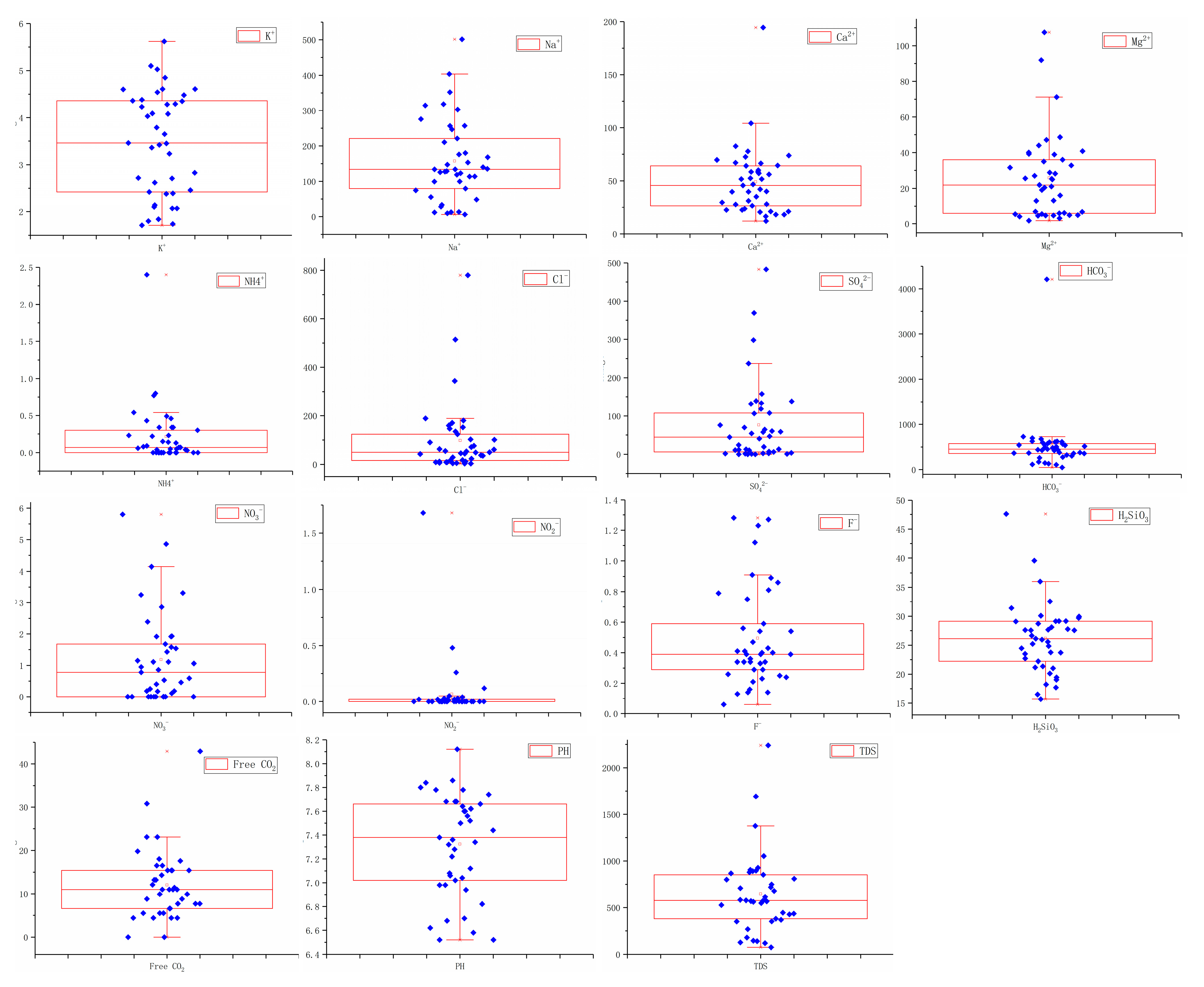
The above analysis can find that there are some ions with large coefficient of variation in the water pattern, which indicates that they are sensitive ions that change with environmental factors. However, it is unscientific to determine whether they are the categories with large variability simply through the magnitude of numerical variation. The occurrence of abnormal values and the analysis of their causes are also important opportunities to study the evolution characteristics of groundwater in the region. Therefore, based on the above analysis, the concept of box graph [31] is introduced to find the abnormal values of various ions in water; the box graph can calculate the upper edge, the upper quartile Q3, the median, the lower quartile Q1 and the lower edge, and all apart from the upper and lower edges of a group of data are abnormal values, as shown in Figure 3, which is the box graph of anions and cations.
By comparing the background values of India [32,33,34], the United States [35,36], Iran [37,38] and Xilinhot City [39,40] near the study area, it can be found that the concentration of Na+ at the measuring point CQ22 is abnormally large, with the concentration value of 501.2 mg/L. The concentration of Ca2+ at the measuring point CQ22 is abnormally large, with the concentration value of 194.39 mg/L. The concentrations of Mg2+ at the measuring points CQ20 and CQ24 are abnormally large, with the concentration values of 107.45 mg/L and 91.89 mg/L, respectively. The concentration of Cl values at the measuring points CQ22, CQ20 and CQ23U are abnormally large, with the concentration values of 779.77 mg/L, 514.07 mg/L and 343.89 mg/L, respectively. The concentration of SO42− values of measuring points CQ22, CQ20 and CQ23U are abnormally large, with the concentration values of 483.2 mg/L, 368.89 mg/L and 297.8 mg/L, respectively. The concentration of HCO3 at the measuring point CQ23U is abnormally large, with the concentration value of 4210.2 mg/L. The concentration of NO3 at the measuring points W1, CQ2 and CQ3 are abnormally large, with the concentration values of 5.8 mg/L, 4.86 mg/L and 4.14 mg/L, respectively. The concentration of NO2 at the measuring point DM6, R1, DM5 and DM7 are abnormally large, with the concentration values of 1.68 mg/L, 0.48 mg/L, 0.26 mg/L and 0.12 mg/L, respectively. The concentration of F in measuring points DM8, CQ16, R1 and DM11 are abnormally large, with the concentration values of 1.28 mg/L, 1.27 mg/L, 1.23 mg/L and 1.12 mg/L, respectively. The concentration of H2SiO3 at measuring points W1 and CQ9D are abnormally large, with the concentration value of 47.58 mg/ m2, respectively.
For the above individual limit values, we can consider that they are caused by accidental factors, but the two measuring points CQ20 and CQ22 show limit values on multiple ion concentrations. From the map, it can be found that CQ20 and CQ22 are the two closest points to the Datang Coal Chemical Plant, which can confirm that the coal chemical plant has a certain impact on the groundwater in the region. The most severely exceeded ions in all samples in the region are NH4+, and NO2. It shows that the local groundwater is polluted to a certain extent, and that the scope of influence of the coal chemical plant on the groundwater is extremely limited. Further analysis of the measuring points around the Dongming mining area shows that only DM4 exceeds the standard value in 14 points where NH4+ exceeds the standard value, and the concentration is less than 0.77 mg/L. Only DM6, DM12D, DM9 and DM11 exceed the standard value in 12 points where Na+ exceeds the standard value, and the concentration is less than 314.42 mg/L, which shows that the impact of coal mining on the groundwater is also extremely limited. At least, it does not occupy a dominant position. So it can be analyzed that the local groundwater is mainly polluted by a large quantity of local cattle, sheep and other livestock manure, as well as industrial and domestic sewage pollution. On the other hand, there is a large amount of cultivated land distributed in the study area. In order to maintain the growth of crops, a large number of chemical fertilizers need to be used for a long time. The absorption capacity of crops to nitrogen fertilizer is weak, which increases the amount of nitrate in groundwater. Under the action of anaerobic microorganisms, nitrate in groundwater is reduced to nitrite and ammonia, which can increase the mass concentration of NH4+ and NO2.
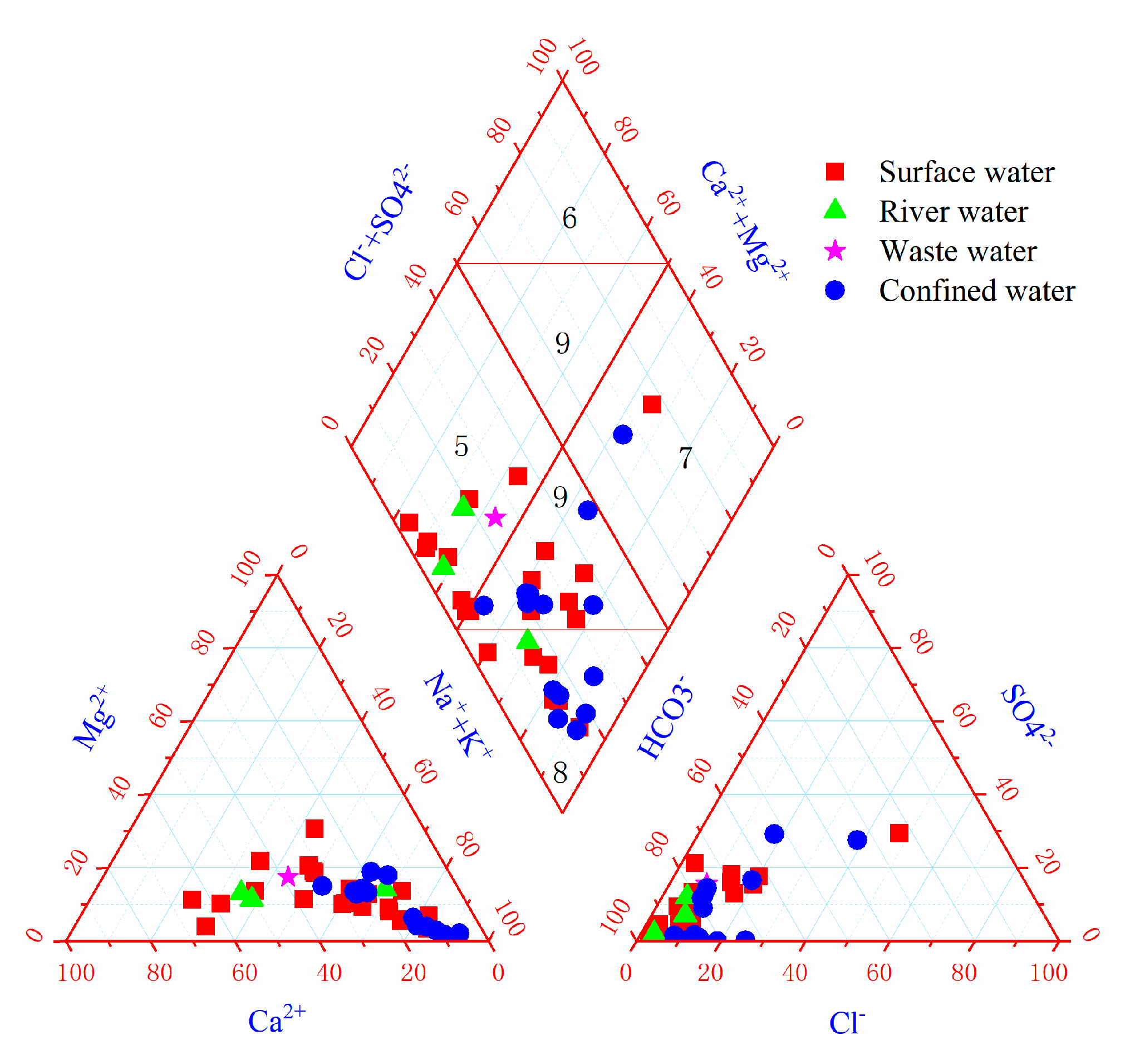
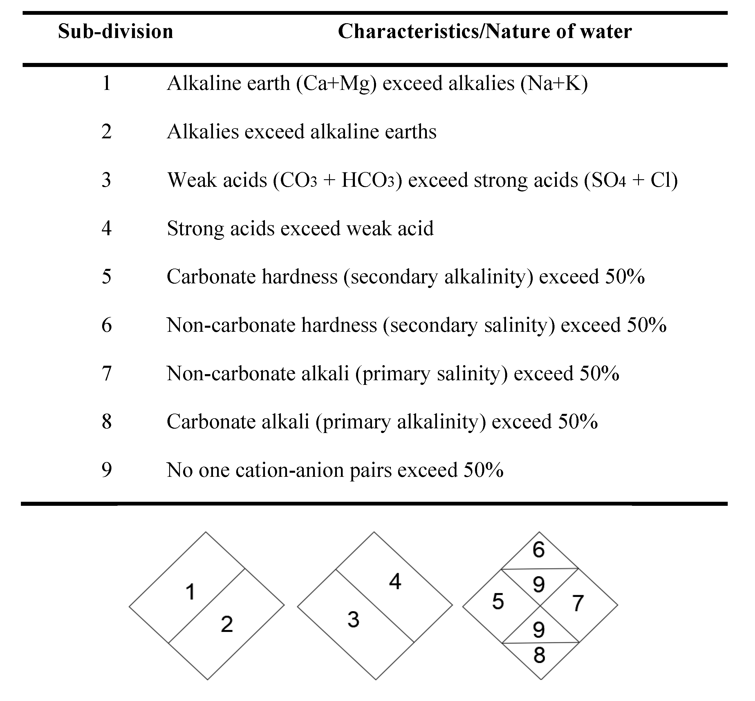
The Piper triple plot is a graphical representation of the concentration of major anions and cations in water, and is widely used to evaluate the relationship between dissolved ion components and major water types [41,42,43]. The three-line graph consists of three parts. The lower left corner and the lower right corner are two isosceles triangles representing the concentration of cations and anions, respectively. There is a diamond in the upper middle, and the side length of all graphs is 100 equal fractions. All data need to be normalized when plotting, representing the relative concentration of chemical components. Therefore, the ion concentration of each triangle will finally converge to a point. Then, the left and right triangles are used to make rays along the outer side parallel to the triangle, intersecting at a point within the diamond region. This point can represent the general chemical properties of groundwater and the relative composition of groundwater with anion cation pairs. The diamond was divided into nine zones. The characteristics of groundwater represented by each zone are shown in Figure 4 and Figure 5.
We learn that the water chemical types in the study area are mainly HCO3 Na and HCO3Ca·Na, the groundwater chemical types are mainly HCO3 Na and HCO3Na·Ca, the confined water chemical type is HCO3 Na. In total, high salinity is low. Except for the two points of CQ20 and CQ22, all the points are in zone 3, indicating that the water samples in the study area show overall carbonation. All of the remaining confined water is in zones 8 and 9, showing Carbonate alkali (primary alkalinity) exceeding 50% and no cation-anion pairs exceeding 50%.

3.3. Influencing Factors of Hydrochemical Characteristics

3.3.1. Rock Leaching and Evaporation Concentration

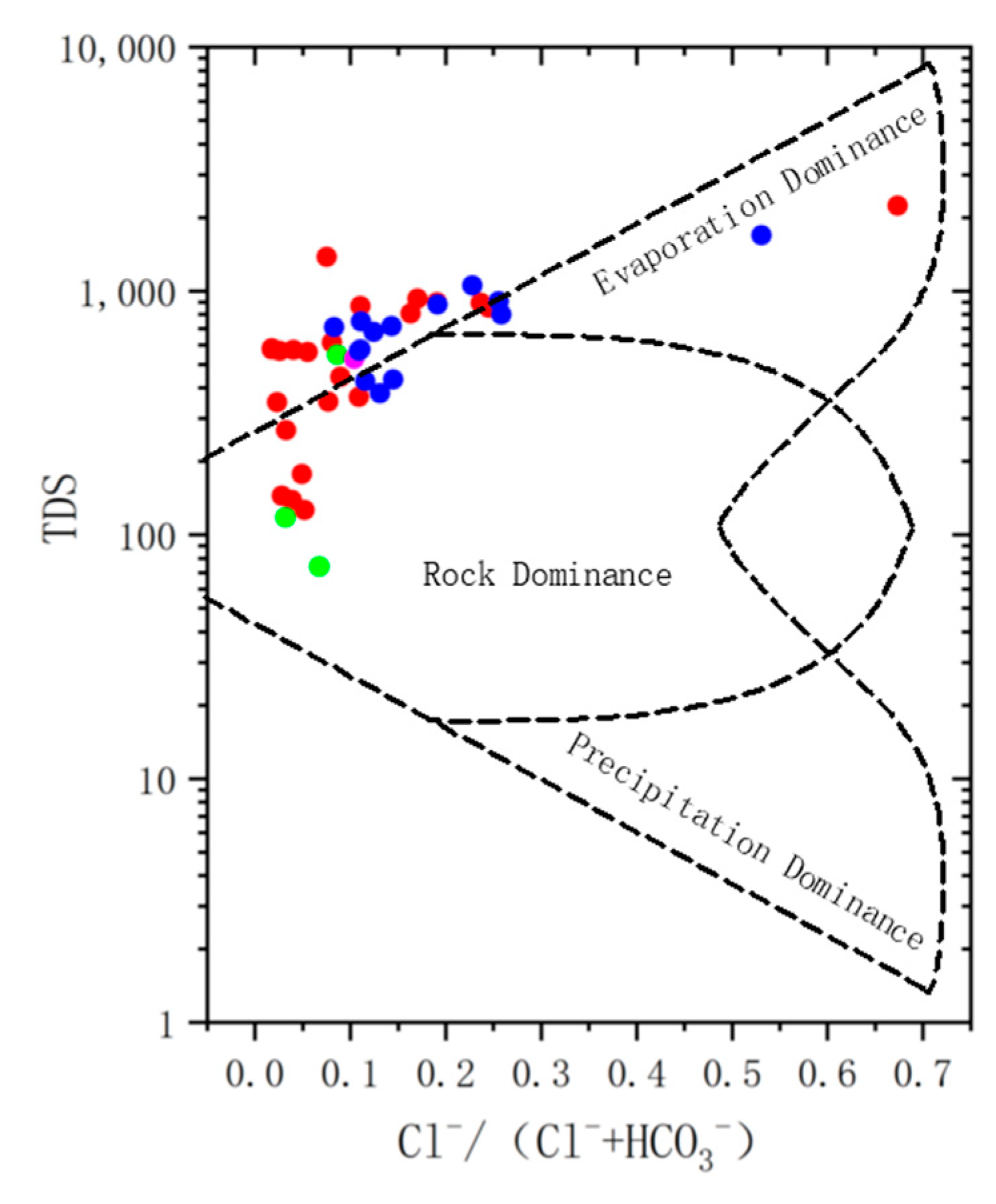
The Gibbs chart is used to draw the correlation between the semi-log value of TDS and the ratio of Na+(/Na++Ca2+) and Cl(/Cl+HCO3). Gibbs studied the major surface rivers in the world and divided the control factors of natural water into three types: evaporation concentration, rock weathering and atmospheric deposition [44].
As shown from Figure 6 and Figure 7, most of the phreatic water and confined water in the study area fell in the middle of the figure, indicating that they were mainly affected by rock leaching and evaporation.
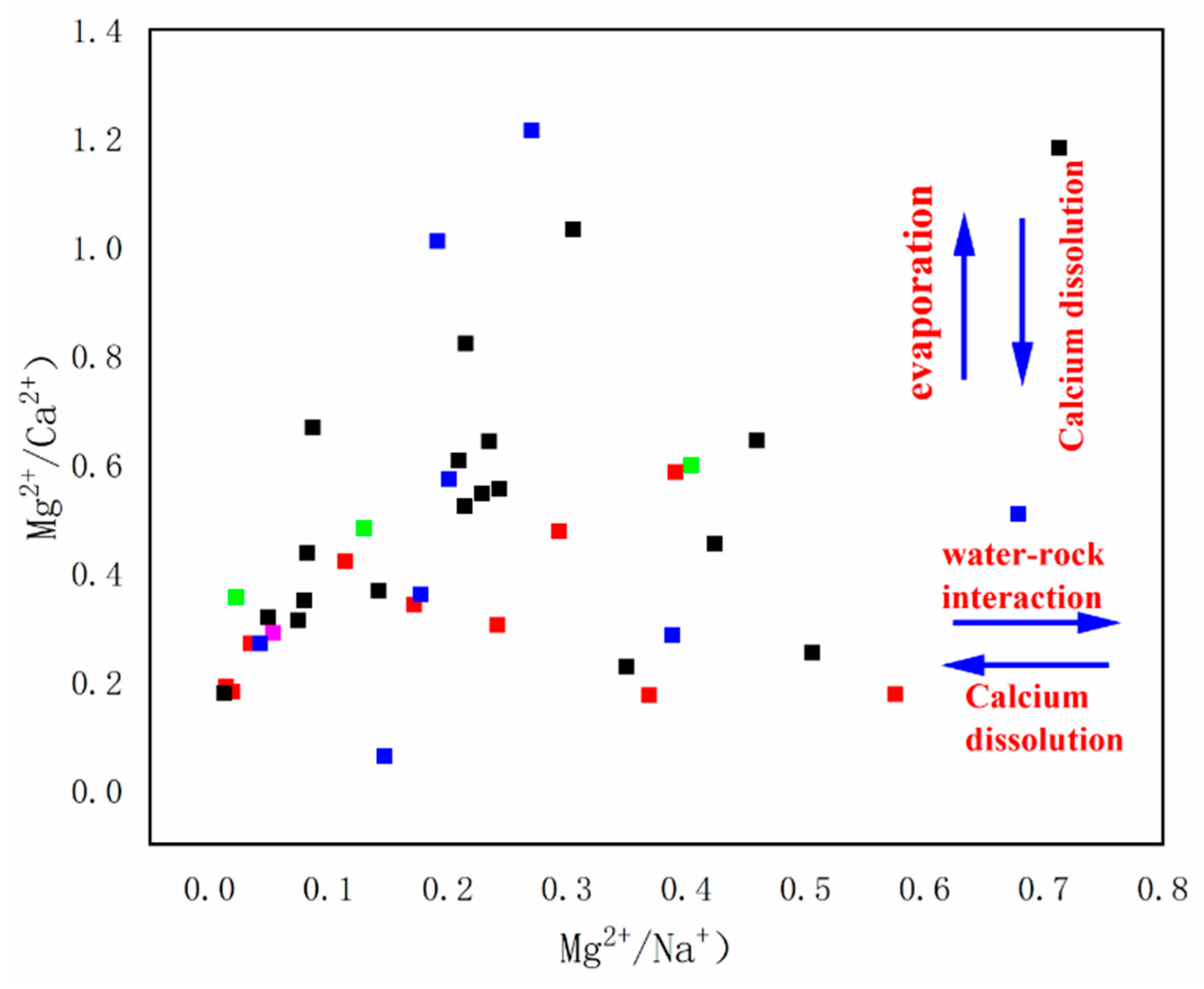
Similarly, the correlation between Mg2+/Ca2+ and Mg2+/Na+ can be used to determine whether groundwater is affected by evaporation and salt leaching processes. As can be seen from Figure 8, the values of Mg2+/Ca2+ and Mg2+/Na+ are relatively small. Except for a few two points, the values of other water sample points are all less than 1. Therefore, it can be considered that the groundwater in the study area is mainly affected by the dissolution of sodium salt and calcium salt.

3.3.2. Ion Exchange

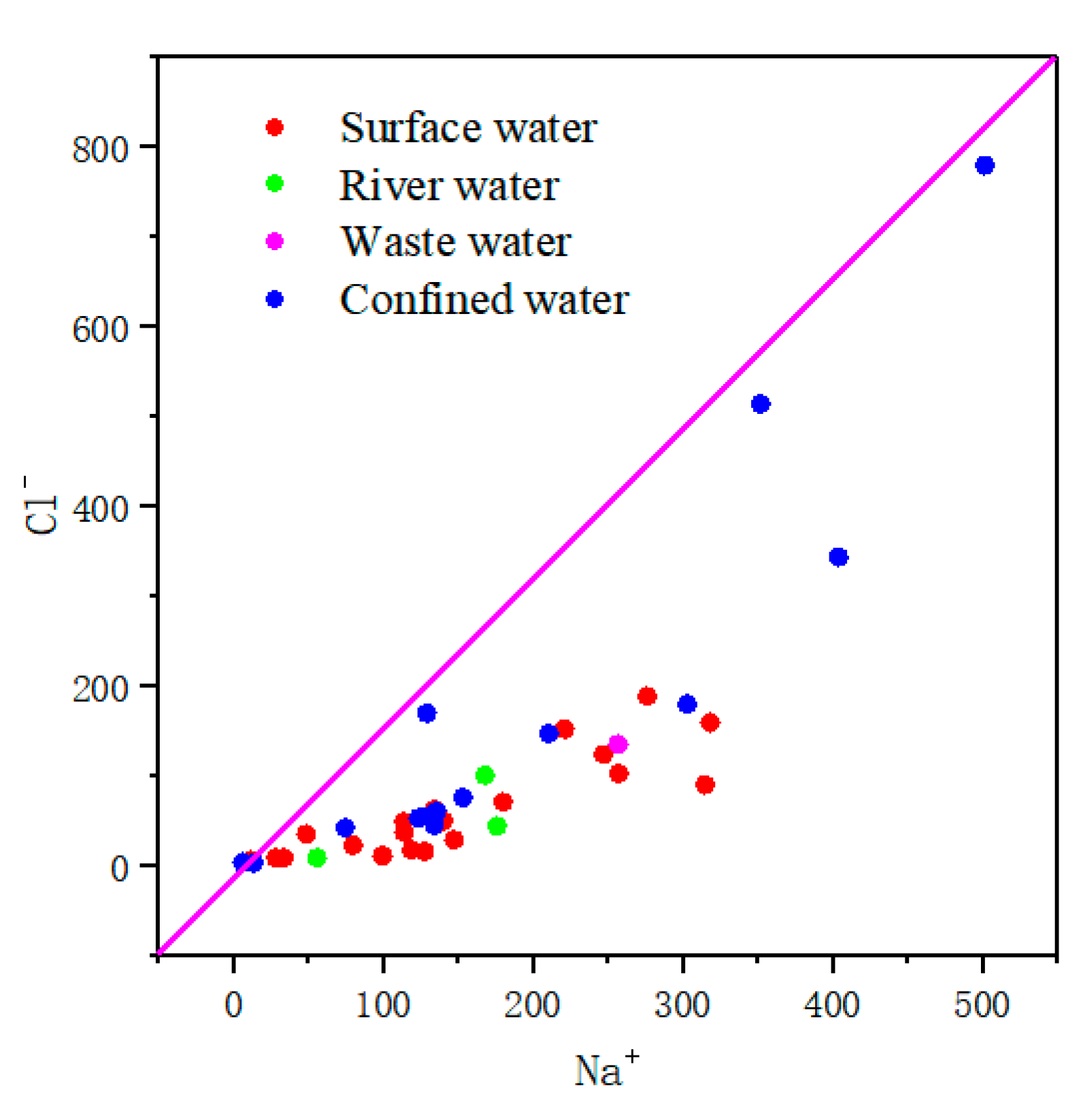
In general, cation exchange can change some major chemical ions in groundwater [36]. Under natural conditions, the amount of Na+ plus should be equal to the amount of Cl minus. As can be seen from the scatter diagram of Na+ and Cl correlation in the study area (Figure 9), the water sample points of phreatic water and confined water in the study area are all below y = X, that is, the amount of Na+ is greater than the amount of Cl, indicating that the excess Na+ is the result of cation exchange.
The values of (Ca2++Mg2+-HCO3-SO42−)/(Na+-Cl) are often used to investigate whether Na+ in aqueous media undergoes ion-exchange interactions with Ca2+ and Mg2+ in groundwater [21]. It can be seen from Figure 10 that (Ca2++Mg2+-HCO3-SO42−) is negatively correlated with (Na+-Cl), and both are located on the y = −x line and below the point (0, 0), fully indicating that the excess Na+ is obtained through the exchange of Na+ in aqueous media with Ca2+ and Mg2+ in groundwater.

3.4. Grade Assessment of Groundwater Irrigation

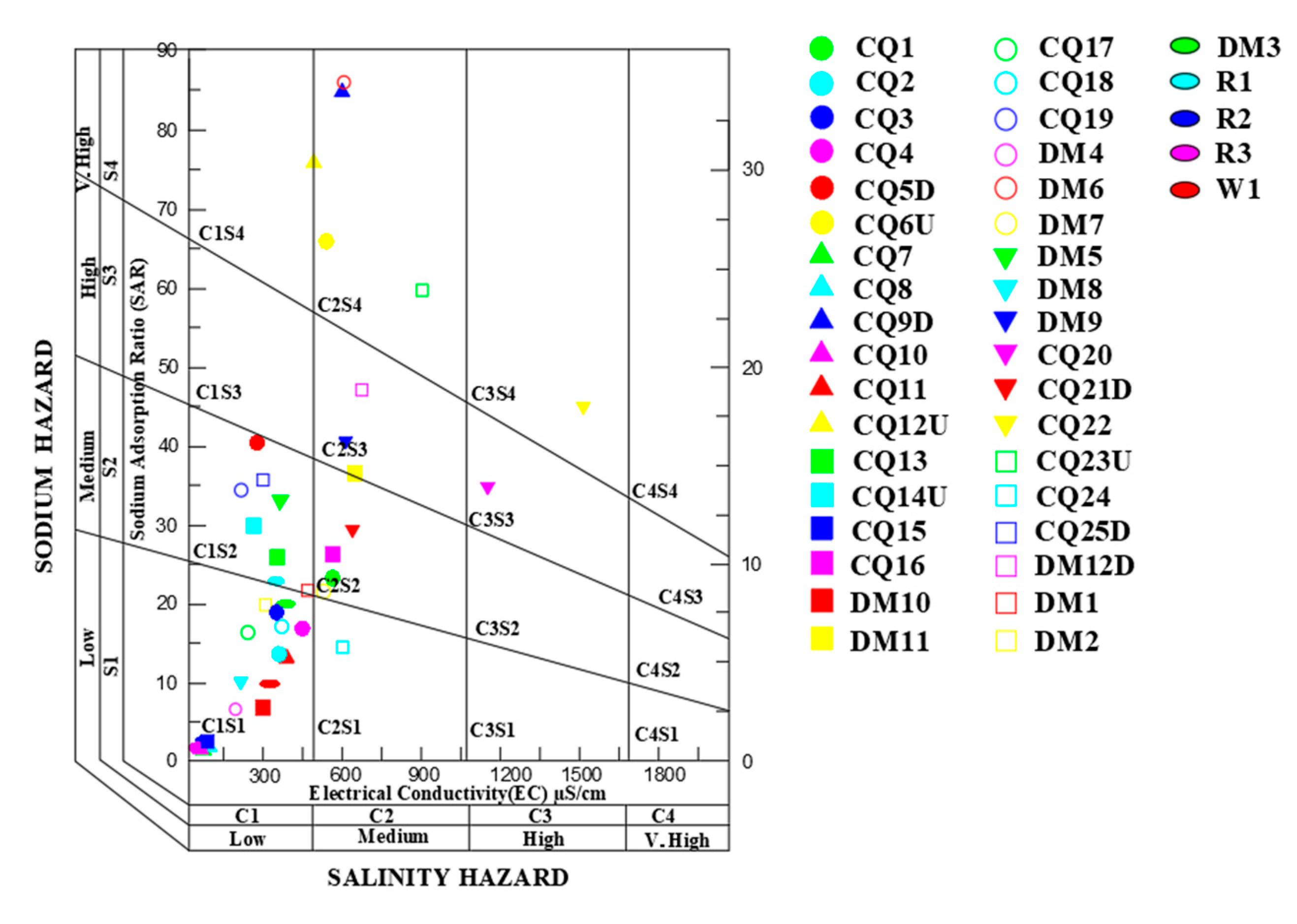
Chenbaerhu Banner coalfield is located in the eastern grassland area, surrounded by pastoral areas, among which the Hulunbeier Grassland is one of the world-famous grasslands. It is worth discussing whether groundwater is suitable for irrigation. The percentage of Na and SAR in groundwater samples can affect the replacement of cations in clay minerals in soil, thus producing sodium or damaging soil permeability [45]. EC can reflect TDS concentration in groundwater [46,47]. Therefore, the Wilcox chart [48], with % Na, SAR and EC values as the classification standard, and the famous American Salinity Laboratory Classification Chart [49], are used to evaluate the grade of irrigation water, in which the Wilcox chart represents both % Na and EC percentages, and the water samples are divided into five categories, namely C1S1, C2S1, C2S2, C3S1 and C4S1, which represent excellent, good permit, permit suspect, suspect unsuitable and unsuitable respectively. The calculation formulae are shown in Formulas (1) and (2), the calculation results are shown in Table 1, and the classification results are shown in Figure 11 and Figure 12.
S A R = N a + ( C a 2 + + M g 2 + ) / 2
% N a + = K + + N a + K + + N a + + C a 2 + + M g 2 + × 100 %
The USSL diagram shows that there are 19 water samples with high salinity and low alkalinity, namely CQ2, CQ3, CQ4, CQ7, CQ8, CQ10, CQ11, CQ15, DM10, CQ17, CQ18, DM4, DM8, CQ24, DM2, R3, R2, W1, and DM3; there were 11 water samples belonging to high salinity, moderate alkalinity, which were labeled CQ1, CQ5D, CQ13, CQ14U, CQ16, CQ19, DM5, CQ21D, CQ25D, DM1 and R1; there were 4 water samples with high salinity and high alkalinity, which were labeled DM11, DM9, CQ20 and DM12D; and the other 6 water samples are of very high salinity and high alkalinity, namely CQ6U, CQ12U, CQ9D, DM6, CQ23U and CQ22. The results of USSL map show that the local area as a whole is characterized by high salinity.
The results of Wilcox diagram show that 10 water samples from the Chenbaerhu Banner coalfield in Inner Mongolia are in the good permission range, indicating that they can be used as irrigation water. These water samples are numbered as CQ2, CQ3, CQ4, CQ11, DM10, CQ18, CQ24, DM2, R2 and W1. The water samples numbered CQ7, CQ8, CQ10, CQ15, CQ17, DM4, DM8, R2 and R3 were displayed in an excellent range, indicating that these nine water sample collection areas could be irrigated. Fifteen of the water samples were in the permit suspicious range. These were numbered CQ1, CQ5D, CQ13, CQ14U, CQ16, DM11, CQ19, DM7, DM5, DM9, DM21D, CQ25D, DN12D, DM1, R1. The remaining six water samples are in suspect–unsuitable range, namely CQ6U, CQ9D, CQ12U, DM6, CQ20 and CQ23U. There was one water sample in the unsuitable interval, CQ22, indicating that the water sample collection area was not suitable for irrigation. In the analysis of seven samples in the suspicious–unsuitable section and unsuitable irrigation section, there are four samples belong to the confined water, accounting for 30.76% of the entire thirteen confined water samples, and there are three samples belongs to phreatic water, accounting for 12.5% of the entire thirteen confined water samples. For in-depth analysis of the external affected conditions of these seven points, CQ6U is located in the northwest of Chenbarhu Banner, and CQ20 is located in the northwest of Xiyutala town. Both are mainly affected by domestic water. CQ9D and CQ12U are located in the arid grassland at the foot of the Sanqi Mountain in the north of Chenbahu Banner. They are mainly affected by pasture production activities. CQ22 and CQ23U are located in farmland, and they are mainly affected by agricultural production activities. DM6 is located on the southeast side outside of the Dongming coal mine, separated with a road from the shortest mine boundary distance of 210 m, while DM7, only 10 m away from DM6, is in the permit suspicious range. In addition, a total of six samples were tested around the Dongming coal mine, except for DM6 and DM7, and the other samples are in the irrigable range, which indicates that the coal mine’s impact on groundwater chemistry characteristics is extremely limited. DM6 and DM7 are more likely to be affected by the dust of road coal trucks, and the local groundwater pollution is mainly caused by a large quantity of local livestock manure such as that of cattle and sheep, industrial and domestic sewage pollution and cultivated land fertilizer.

4. Conclusions

(a)
The main chemical types of river water are HCO3Na and HCO3Ca·Na, the main chemical types of surface water are HCO3Na and HCO3Na·Ca, and the main chemical type of confined water is HCO3Na. The salinity of water samples in the study area is generally low, showing bicarbonate;
(b)
Among the human factors affecting the change of hydrochemical characteristics, coal chemical plants and coal mining enterprises have limited influence on the change of groundwater chemical characteristics. The pollution of a large quantity of local cattle and sheep manure, industrial and domestic sewage and farmland fertilization are the main reasons for the increase of local underground NH4+ and NO2 mass concentrations, because the nitrate of groundwater is reduced to nitrite and ammonia under the action of anaerobic microorganisms;
(c)
The natural factors for the change of hydrochemical characteristics mainly include the internal influence of rocks and water, which is mainly manifested in the leaching of sodium and calcium salts in rocks, and the ion exchange between Na+ in aqueous media and Ca2+ and Mg2+ in groundwater;
(d)
The results show that 46% of the water samples can be directly used for irrigation and 16% cannot be used for irrigation. Different water samples with different hydrochemical characteristics can be classified, and different measures can be taken to improve the use and management of groundwater chemistry characteristics. Regulating agricultural activities and sewage discharge is the main way to improve the water chemistry characteristics in the study area, to strengthen the monitoring of the groundwater environment, and to increase the investment in water source treatment.

Author Contributions

Conceptualization, W.S. and F.F.; methodology, W.S., F.F. and K.Y.; formal analysis, W.S., F.F. and Y.Z.; investigation, W.S., F.F. and K.Y.; data curation, W.S. and F.F.; writing—original draft preparation, W.S.; project administration, J.Z.; funding acquisition, W.S. and F.F.; revision and proof, J.S. All authors have read and agreed to the published version of the manuscript.

Funding

This work is supported by National Natural Science Foundation of China (No. 52104115); the Institute of Energy, Hefei Comprehensive National Science Center under Grant (No. 21KZS215); Independent project of the State Key Laboratory of Coal Mining Response and Disaster Prevention and Control (No. SKLMRDPC19ZZ08); Research on key technologies for development and utilization of abandoned mine resources and underground space (No. 20191101016).

Institutional Review Board Statement

Not applicable.

Informed Consent Statement

Not applicable.

Data Availability Statement

The authors confirm that the data supporting the findings of this study are available within the article.

Acknowledgments

We appreciate the support from the State Key Laboratory of Mining Response and Disaster Prevention and Control in Deep Coal Mines, and the Institute of Energy, Hefei Comprehensive National Science Center. Compliance with ethical standards.

Conflicts of Interest

The authors declare no conflict of interest.

References

  1. Şehnaz, Ş.; Erhan, Ş.; Ayşen, D. Evaluation of water quality using water quality index (WQI) method and GIS in Aksu River (SW-Turkey). Sci. Total Environ. 2017, 584–585, 131–144. [Google Scholar]
  2. Adimalla, N.; Li, P.; Venkatayogi, S. Hydrogeochemical evaluation of groundwater quality for drinking and irrigation purposes and integrated interpretation with water quality index studies. Environ. Process. 2018, 5, 363–383. [Google Scholar] [CrossRef]
  3. Selemani, J.R.; Zhang, J.; Muzuka, A.N.; Njau, K.N.; Zhang, G.; Maggid, A.; Mzuza, M.K.; Jin, J.; Pradhan, S. Seasonal water chemistry variability in the Pangani River basin, Tanzania. Environ. Sci. Pollut. Res. 2017, 24, 26092–26110. [Google Scholar] [CrossRef] [PubMed]
  4. Varol, S.; Davraz, A. Evaluation of the groundwater quality with WQI (Water Quality Index) and multivariate analysis: A case study of the Tefenni plain (Burdur/Turkey). Environ. Earth Sci. 2015, 73, 1725–1744. [Google Scholar] [CrossRef]
  5. Edet, A.; Ukpong, A.; Nganje, T. Hydrochemical studies of Cross River Basin (southeastern Nigeria) river systems using cross plots, statistics and water quality index. Environ. Earth Sci. 2013, 70, 3043–3056. [Google Scholar] [CrossRef]
  6. Arumugam, K.; Elangovan, K. Hydrochemical characteristics and groundwater quality assessment in Tirupur region, Coimbatore district, Tamil Nadu, India. Environ. Geol. 2009, 58, 1509. [Google Scholar] [CrossRef]
  7. Chenini, I.; Khmiri, S. Evaluation of ground water quality using multiple linear regression and structural equation modeling. Int. J. Environ. Sci. Technol. 2009, 6, 509–519. [Google Scholar] [CrossRef] [Green Version]
  8. Galbraith, L.M.; Burns, C.W. Linking land-use, water body type and water quality in southern New Zealand. Landsc. Ecol. 2007, 22, 231–241. [Google Scholar] [CrossRef]
  9. Rao, Y.S.; Reddy, T.; Nayudu, P. Groundwater quality in the Niva river basin, Chittoor district, Andhra Pradesh, India. Environ. Geol. 1997, 32, 56–63. [Google Scholar]
  10. Fauriel, S.; Laloui, L. A bio-chemo-hydro-mechanical model for microbially induced calcite precipitation in soils. Comput. Geotech. 2012, 46, 104–120. [Google Scholar] [CrossRef]
  11. Choo, J.; Sun, W. Cracking and damage from crystallization in pores: Coupled chemo-hydro-mechanics and phase-field modeling, Comput. Methods Appl. Mech. Eng. 2018, 335, 347–379. [Google Scholar] [CrossRef]
  12. Ghorbani, J.; El-Zein, A.; Airey, D.W. Thermo-elasto-plastic analysis of geosynthetic clay liners exposed to thermal dehydration. Environ. Geotech. 2018, 8, 566–580. [Google Scholar] [CrossRef]
  13. Penga, S.; Fenga, F.; Dua, W.; Hea, Y.; Chonga, S.; Xinga, Z. Analysis of water chemical characteristics and application around large opencast coal mines in grassland: A case study of the North Power Shengli coal mine. Desalination Water Treat. 2019, 141, 149–162. [Google Scholar] [CrossRef]
  14. Tang, K.; Hou, J.; Tang, K. Assessment of groundwater quality in China: Ⅰ. Hydrochemical characteristics of groundwater in plain area. Water Resour. Prot. 2006, 22, 1–5. [Google Scholar]
  15. He, X.; Wu, J.; He, S. Hydrochemical characteristics and quality evaluation of groundwater in terms of health risks in Luohe aquifer in Wuqi County of the Chinese Loess Plateau, northwest China. Hum. Ecol. Risk Assess. Int. J. 2019, 25, 32–51. [Google Scholar] [CrossRef]
  16. Cao, G.Y.; Yang, H.T.; Ren, Y.J. Hydrogeochemical characteristics and causes of groundwater in Chengjiaying Basin, Inner Mongolia. Geol. Chem. Miner. 2019, 41, 285–290. [Google Scholar]
  17. Xiao, M.; Han, Z.; Xu, S.; Wang, Z. Temporal Variations of Water Chemistry in the Wet Season in a Typical Urban Karst Groundwater System in Southwest China. Int. J. Environ. Res. Public Health 2020, 17, 2520. [Google Scholar] [CrossRef] [Green Version]
  18. Howladar, M.F.; Deb, P.K.; Muzemder, A.S.H.; Ahmed, M. Evaluation of water resources around Barapukuria coal mine industrial area, Dinajpur, Bangladesh. Appl. Water Sci. 2014, 4, 203–222. [Google Scholar] [CrossRef] [Green Version]
  19. JKim, G.; Ko, K.-S.; Kim, T.H.; Lee, G.H.; Song, Y.; Chon, C.-M.; Lee, J.-S. Effect of mining and geology on the chemistry of stream water and sediment in a small watershed. Geosci. J. 2007, 11, 175–183. [Google Scholar]
  20. Lin, D.; Qiang, W.; Zhang, R.; Song, Y.; Chen, S.; Pei, L.; Liu, S.; Bi, C.; Lv, Z.; Huang, S. Environmental characteristics of groundwater: An application of PCA to water chemistry analysis in Yulin. J. China Univ. Min. Technol. 2007, 17, 73–77. [Google Scholar]
  21. Zhang, B.; Zhao, D.; Zhou, P.; Qu, S.; Liao, F.; Wang, G. Hydrochemical Characteristics of Groundwater and Dominant Water–Rock Interactions in the Delingha Area, Qaidam Basin, Northwest China. Water 2020, 12, 836. [Google Scholar] [CrossRef] [Green Version]
  22. Cario, G.; Casavola, A.; Gjanci, P.; Lupia, M.; Petrioli, C.; Spaccini, D. Long lasting underwater wireless sensors network for water quality monitoring in fish farms. In Proceedings of the OCEANS 2017-Aberdeen, Aberdeen, UK, 19–22 June 2017; pp. 1–6. [Google Scholar]
  23. Mahmud, M.A.; Hussain, K.A.; Hassan, M.; Jewel, A.R.; Shamsad, S.Z. Water quality assessment using physiochemical parameters and heavy metal concentrations of circular rivers in and around Dhaka city, Bangladesh. Int. J. Water Res. 2017, 7, 23–29. [Google Scholar]
  24. Hou, H.; Zhou, J.; Liu, G.; Kong, J.; Enyao, M.; Luo, W. Study on the geographical origin identification of american ginseng based on multi-element analysis and statistical methods. Hubei Agric. Sci. 2020, 59, 151–154. [Google Scholar]
  25. Arkoc, O.; Ucar, S.; Ozcan, C. Assessment of impact of coal mining on ground and surface waters in Tozaklı coal field, Kırklareli, northeast of Thrace, Turkey. Environ. Earth Sci. 2016, 75, 514. [Google Scholar] [CrossRef]
  26. Zhang, H.; Su, L.; Wang, J.; Yang, L.; Wang, D.; Hu, X.; Xiong, L. Study on LA-ICP-MS Determination of Trace Elements in Sulfide Minerals. Hans J. Chem. Eng. Technol. 2019, 9, 401–409. [Google Scholar] [CrossRef]
  27. Jiang, Q.; Han, Y.; Sun, X.; Gong, H.; Qian, W.; Guoxing, L.U. Study on the Determination and Its Difference Analysis of Chloride and Sulfate in Different Soils by Ion Chromatography and Capillary Electrophoresis. Soils 2016, 48, 343–348. [Google Scholar]
  28. Durowoju, O.S.; Ekosse GI, E.; Odiyo, J.O. Occurrence and Health-Risk Assessment of Trace Metals in Geothermal Springs within Soutpansberg, Limpopo Province, South Africa. Int. J. Environ. Res. Public Health 2020, 17, 4438. [Google Scholar] [CrossRef]
  29. Lai, Z.; Lin, F.; Qiu, L.; Wang, Y.; Chen, X.; Hu, H. Development of a sequential injection analysis device and its application for the determination of Mn(II) in water. Talanta 2020, 211, 120752. [Google Scholar] [CrossRef]
  30. General Administration of Quality Supervision I.a.Q.; China S.A.o. Standard for Groundwater Quality; China Environmental Science Press: Beijing, China, 2017; p. 20. [Google Scholar]
  31. Choi, H.; Poythress, J.C.; Park, C.; Jeon, J.J.; Park, C. Regularized boxplot via convex clustering. J. Stat. Comput. Simul. 2019, 89, 1227–1247. [Google Scholar] [CrossRef]
  32. Khare, P. A large-scale investigation of the quality of groundwater in six major districts of Central India during the 2010–2011 sampling campaign. Environ. Monit. Assess. 2017, 189, 429. [Google Scholar] [CrossRef] [PubMed]
  33. Singh, K.K.; Tewari, G.; Kumar, S. Evaluation of Groundwater Quality for Suitability of Irrigation Purposes: A Case Study in the Udham Singh Nagar, Uttarakhand. J. Chem. 2020, 2020, 6924026. [Google Scholar] [CrossRef]
  34. Kumar, P.S.; Balamurugan, P. Evaluation of groundwater quality for irrigation purpose in Attur taluk, Salem, Tamilnadu, India. Water Energy Int. 2018, 61, 59–64. [Google Scholar]
  35. Haile, E.; Fryar, A.E. Chemical evolution of groundwater in the Wilcox aquifer of the northern Gulf Coastal Plain, USA. Hydrogeol. J. 2017, 25, 2403–2418. [Google Scholar] [CrossRef]
  36. Davis, A.; Heatwole, K.; Greer, B.; Ditmars, R.; Clarke, R. Discriminating between background and mine-impacted groundwater at the Phoenix mine, Nevada USA. Appl. Geochem. 2010, 25, 400–417. [Google Scholar] [CrossRef]
  37. Sefati, Z.; Khalilimoghadam, B.; Nadian, H. Assessing urban soil quality by improving the method for soil environmental quality evaluation in a saline groundwater area of Iran. Catena 2019, 173, 471–480. [Google Scholar] [CrossRef]
  38. Shakerkhatibi, M.; Mosaferi, M.; Pourakbar, M.; Ahmadnejad, M.; Safavi, N.; Banitorab, F. Comprehensive investigation of groundwater quality in the north-west of Iran: Physicochemical and heavy metal analysis. Groundw. Sustain. Dev. 2019, 8, 156–168. [Google Scholar] [CrossRef]
  39. Wang, X.; Xiao, W.; Liu, H. Soil moisture characteristic curve and prediction of available water content of overburden in Xilinhot Mining Area. Coal Sci. Technol. 2020, 48, 169–177. [Google Scholar]
  40. Liu, H.; Huang, H.; Shuai, B.; Feng, Y. Study on Stability of East Side Slope of Shengli East No. 2 Mine Based on Geo-Studio Numerical Software. Adv. Geosci. 2020, 10, 622–628. [Google Scholar] [CrossRef]
  41. Alhamed, M. The hydrological and the hydrogeological framework of the Lottenbachtal, Bochum, Germany. Appl. Water Sci. 2017, 7, 315–328. [Google Scholar] [CrossRef] [Green Version]
  42. Arslan, B.; Akün, E. Management, contamination and quality evaluation of groundwater in North Cyprus. Agric. Water Manag. 2019, 222, 1–11. [Google Scholar] [CrossRef]
  43. Benmoussa, Y.; Remini, B.; Remaoun, M. Quality assessment and hydrogeochemical characteristics of groundwater in Kerzaz and Beni Abbes along Saoura valley, southwest of Algeria. Appl. Water Sci. 2020, 10, 170. [Google Scholar] [CrossRef]
  44. Gibbs, R.J. Mechanisms controlling world water chemistry. Science 1970, 170, 1088–1090. [Google Scholar] [CrossRef] [PubMed]
  45. Liu, J.; Jin, D.; Wang, T.; Gao, M.; Yang, J.; Wang, Q. Hydrogeochemical processes and quality assessment of shallow groundwater in Chenqi coalfield, Inner Mongolia, China. Environ. Earth Sci. 2019, 78, 347. [Google Scholar] [CrossRef]
  46. Mahato, M.K.; Singh, P.K.; Tiwari, A.K. Hydrogeochemical evaluation of groundwater quality and seasonal variation in East Bokaro coalfield region, Jharkhand. J. Geol. Soc. India 2016, 88, 173–184. [Google Scholar] [CrossRef]
  47. Mahato, M.K.; Singh, P.K.; Singh, A.K.; Tiwari, A.K. Assessment of hydrogeochemical processes and mine water suitability for domestic, irrigation, and industrial purposes in East Bokaro Coalfield, India. Mine Water Environ. 2018, 37, 493–504. [Google Scholar] [CrossRef]
  48. Wilcox, L. Classification and Use of Irrigation Waters; US Department of Agriculture: Washington, DC, USA, 1955. [Google Scholar]
  49. Handa, B. Studies on US Salinity Laboratory Diagram for Classification of Irrigation Waters. J. Indian Soc. Soil Sci. 1965, 13, 227–232. [Google Scholar]
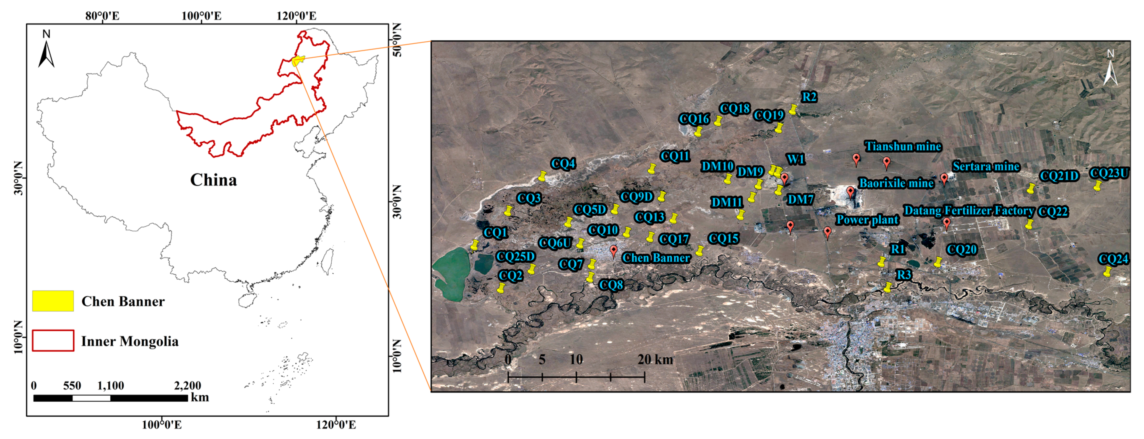
Figure 1. Chenbaerhu Banner coalfield geographical location map; groundwater sampling and ion analysis.
Sustainability 14 16068 g001
Figure 2. Groundwater chemical specific gravity diagram of main anion and anion in 41 samples. (a) Sample 1–21 Specific gravity of the four cations. (b) Sample 2–41 Specific gravity of the four cations. (c) Sample 1–21 Specific gravity of the four anions. (d) Sample 2–41 Specific gravity of the four anions.
Sustainability 14 16068 g002
Figure 3. Boxplot of anion and anion in 41 samples.
Sustainability 14 16068 g003
Figure 4. Comparison of watersamples of each aquifer Piper diagram.
Sustainability 14 16068 g004
Figure 5. Piper Chart Division Water Quality Characteristics Interpretation Chart.
Sustainability 14 16068 g005
Figure 6. Gibbs distribution of cations in groundwater samples.
Sustainability 14 16068 g006
Figure 7. Gibbs distribution of anions in groundwater samples.
Sustainability 14 16068 g007
Figure 8. Distribution Map of Groundwater Ion Reaction.
Sustainability 14 16068 g008
Figure 9. The correlation between Na+ and Cl.
Sustainability 14 16068 g009
Figure 10. The correlation between (Ca2++Mg2+-HCO3-SO42−) and Na+-Cl.
Sustainability 14 16068 g010
Figure 11. Wilcox diagramam.
Sustainability 14 16068 g011
Figure 12. US Salinity Laboratory classification diagramam.
Sustainability 14 16068 g012
Table 1. Calculation results of %Na, SAR and EC.
Water Sample NumberSAREC%Na
CQ133.79 579.77 0.72
CQ213.71 390.92 0.50
CQ30.72 386.41 0.60
CQ417.16 481.59 0.53
CQ5D41.38 290.47 0.86
CQ6U65.92 544.35 0.89
CQ72.22 98.26 0.24
CQ87.37 120.75 0.51
CQ9D84.77 598.27 0.92
CQ103.17 94.34 0.32
CQ1113.56 395.03 0.49
CQ12U76.97 488.41 0.92
CQ1327.13 381.29 0.72
CQ14U30.87 258.38 0.81
CQ153.02 85.78 0.31
CQ1626.98 508.52 0.67
DM106.93 302.34 0.35
DM1136.00 630.75 0.73
CQ1716.99 239.05 0.65
CQ1818.81 388.72 0.61
CQ1933.62 250.13 0.84
DM46.18 181.97 0.38
DM686.46 590.15 0.92
DM722.17 550.70 0.60
DM533.45 417.29 0.76
DM89.73 237.54 0.47
DM940.83 609.40 0.77
CQ2034.20 1150.38 0.63
CQ21D27.55 615.94 0.65
CQ2243.49 1523.43 0.66
CQ23U61.02 935.52 0.82
CQ2413.99 605.84 0.44
CQ25D36.38 294.98 0.83
DM12D47.26 715.57 0.79
DM122.58 461.30 0.63
DM219.50 384.87 0.61
DM320.06 391.51 0.62
R123.69 372.37 0.68
R23.73 79.93 0.38
R32.19 50.36 0.35
W110.47 357.94 0.44
Publisher’s Note: MDPI stays neutral with regard to jurisdictional claims in published maps and institutional affiliations.