


Potential and Opportunities of Use of Postindustrial Buildings and Territories for Urban Development: Case Studies of the Historical Area in Lviv (Ukraine)


Abstract
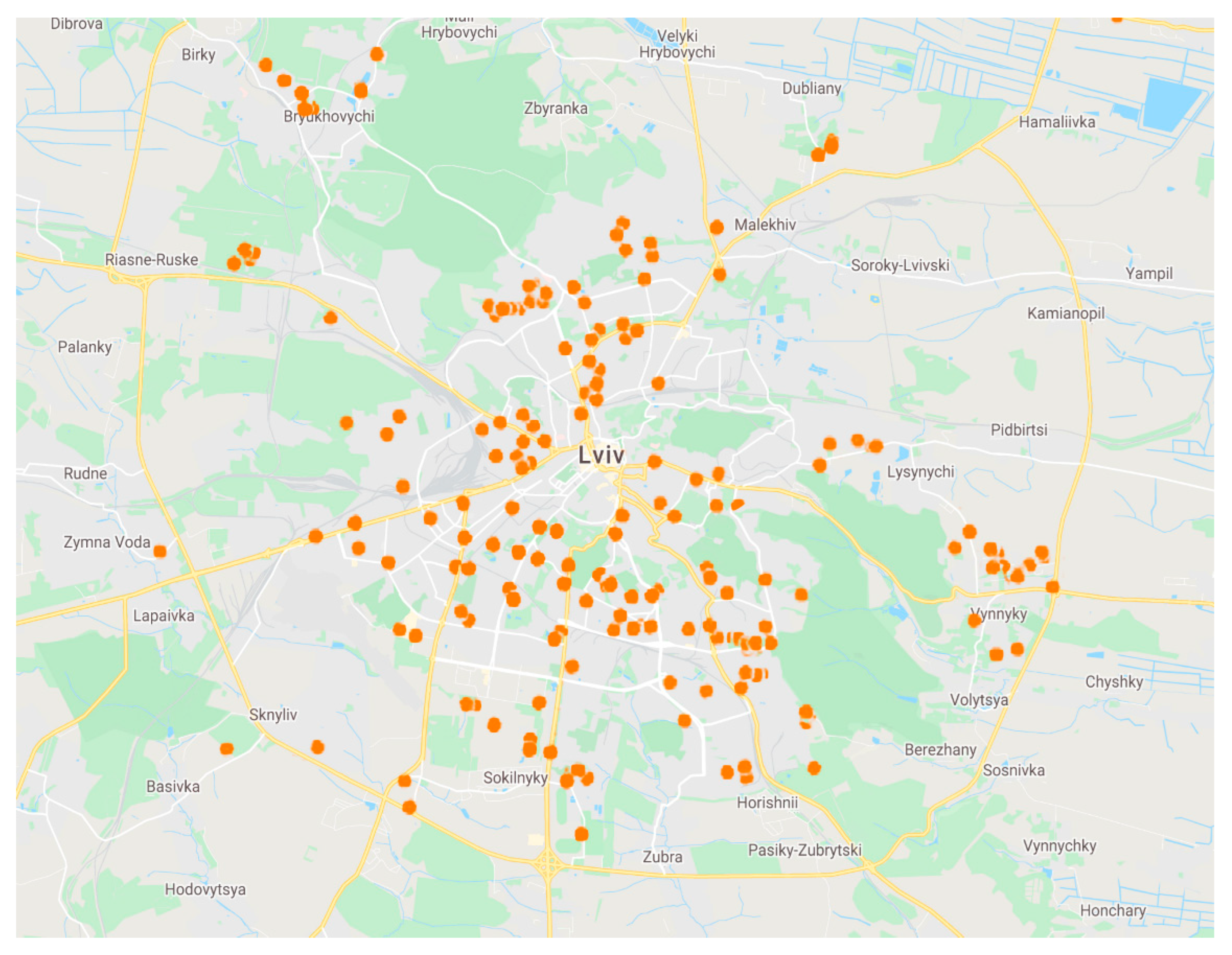
1. Introduction
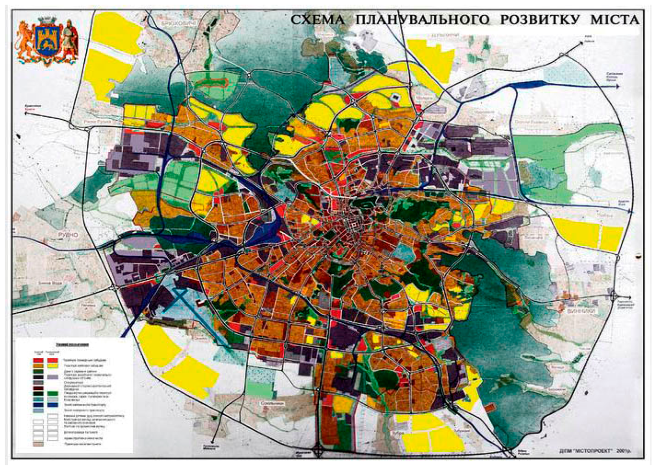
2. Materials and Methods
- -
- connection of the new object with the main functions of the district;
- -
- historical excursion of development of the previous object (territory) for the purpose of revealing valuable characteristics and a critical estimation concerning their preservation and continuation of the tradition of a place;
- -
- comparative analysis of new objects (town-planning formations) with the purposes of the actual general plan of Lviv;
- -
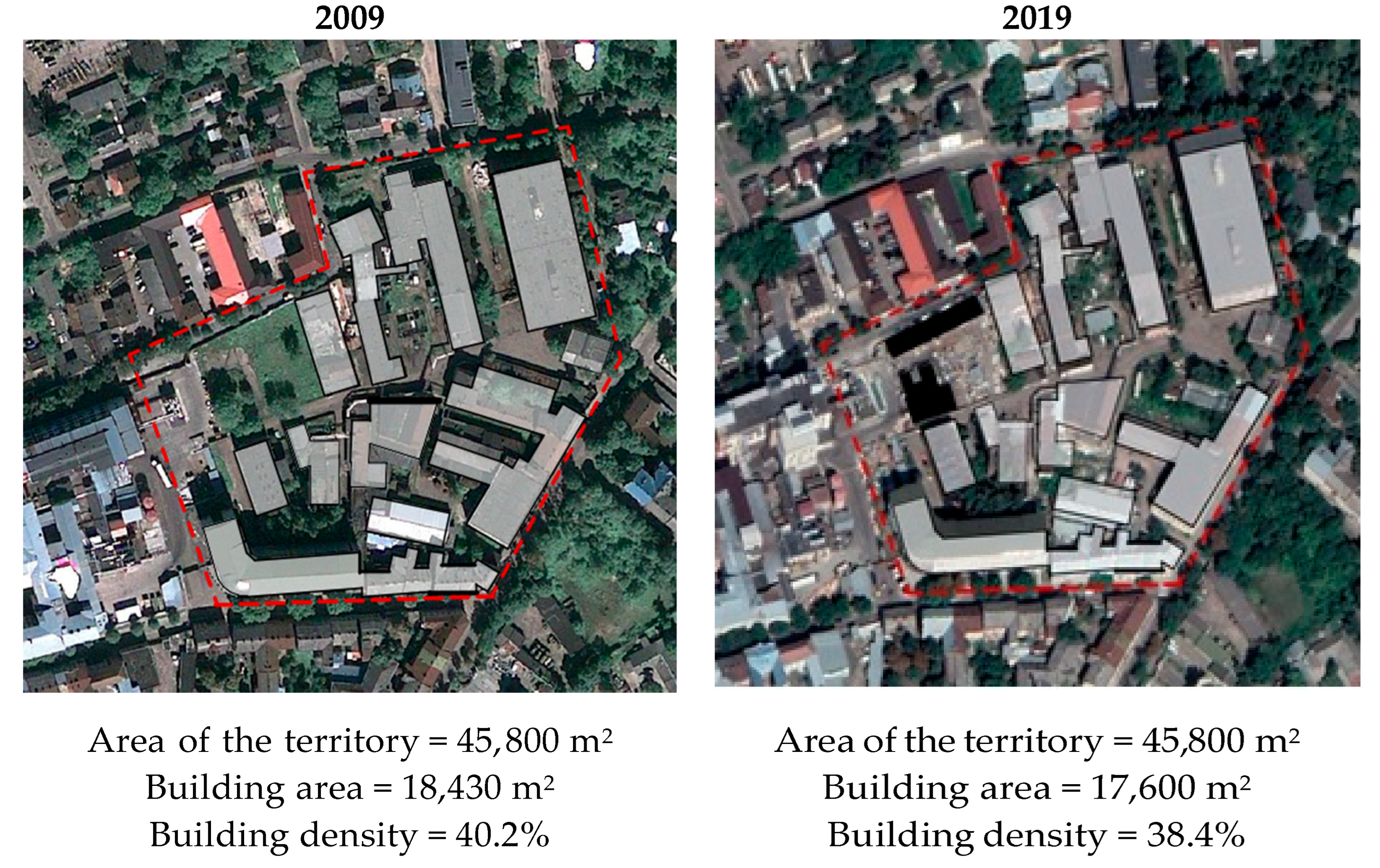
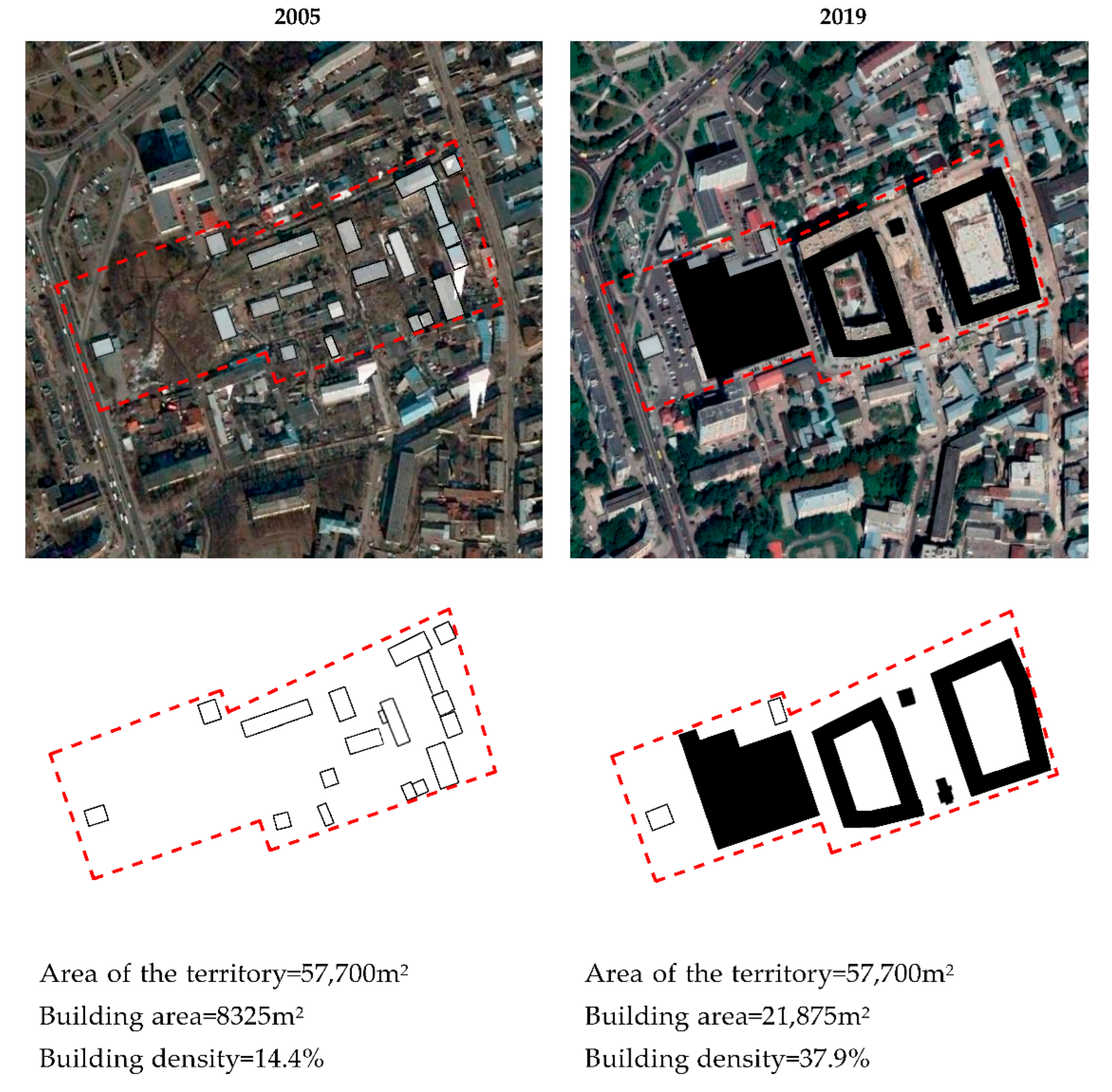
- inspection of a new object on-site—“in situ” and identification of problems or issues of discussion. The received materials were compared to conclusions from world practices, as well as checked if they comply with the development strategy of Lviv. Determining urban density is considered the main technical tool of comparative analysis.

3. Results
3.1. Model 1: Development of the Creative Industry
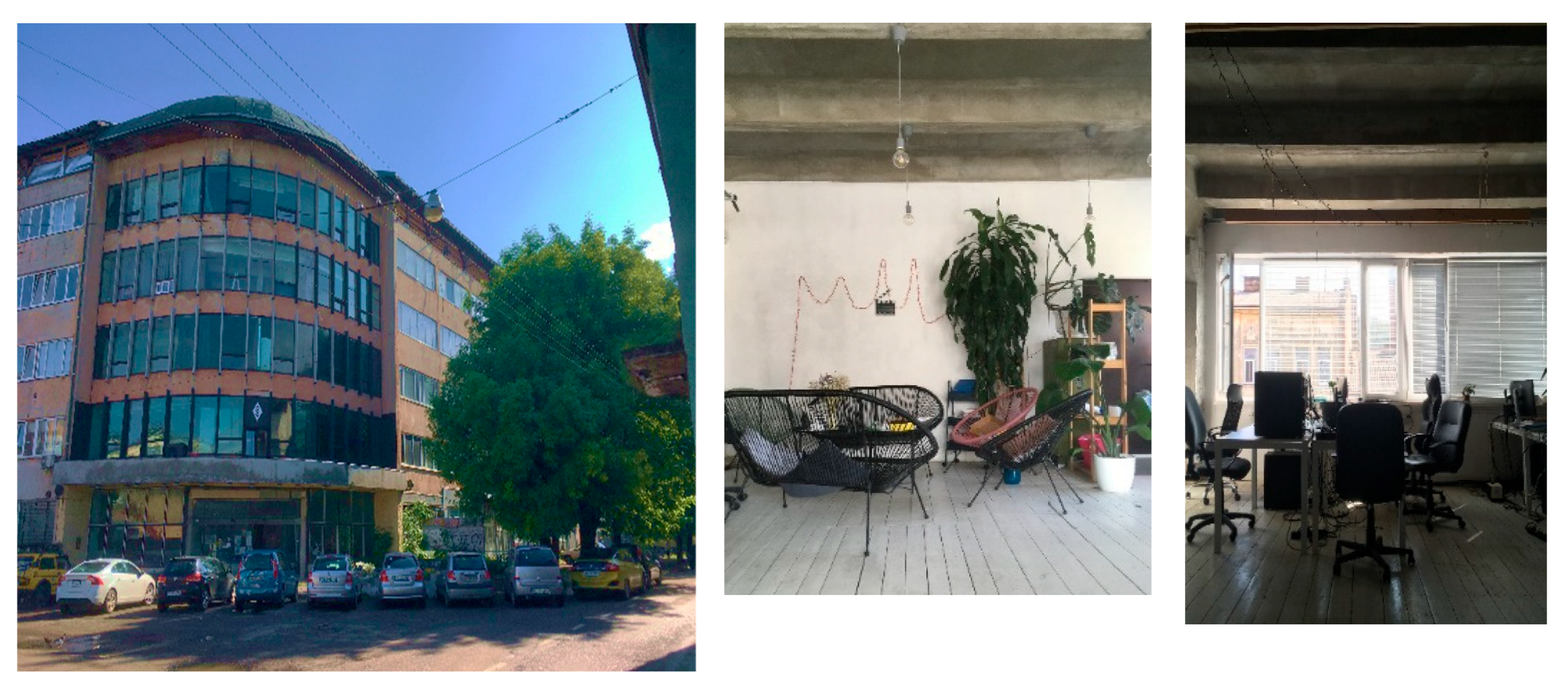
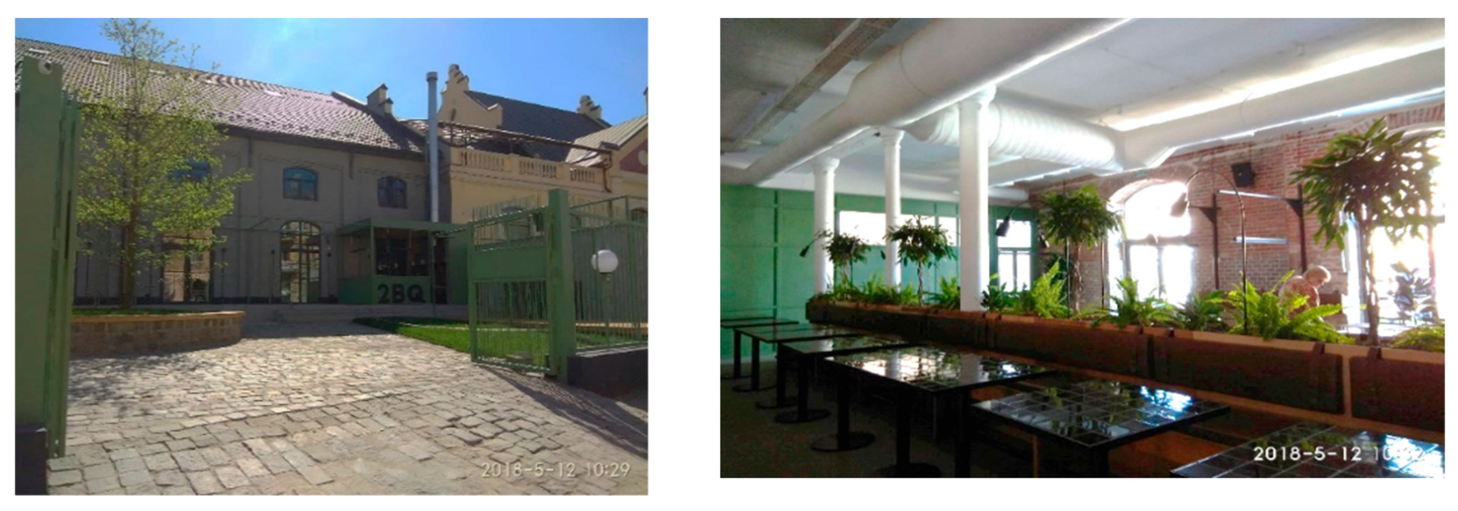
3.1.1. Plant REMA-ReZavod: A Creative Quarter at Zavodska Street
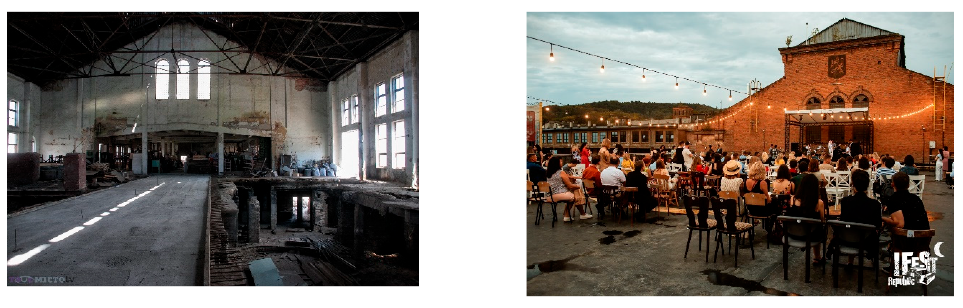
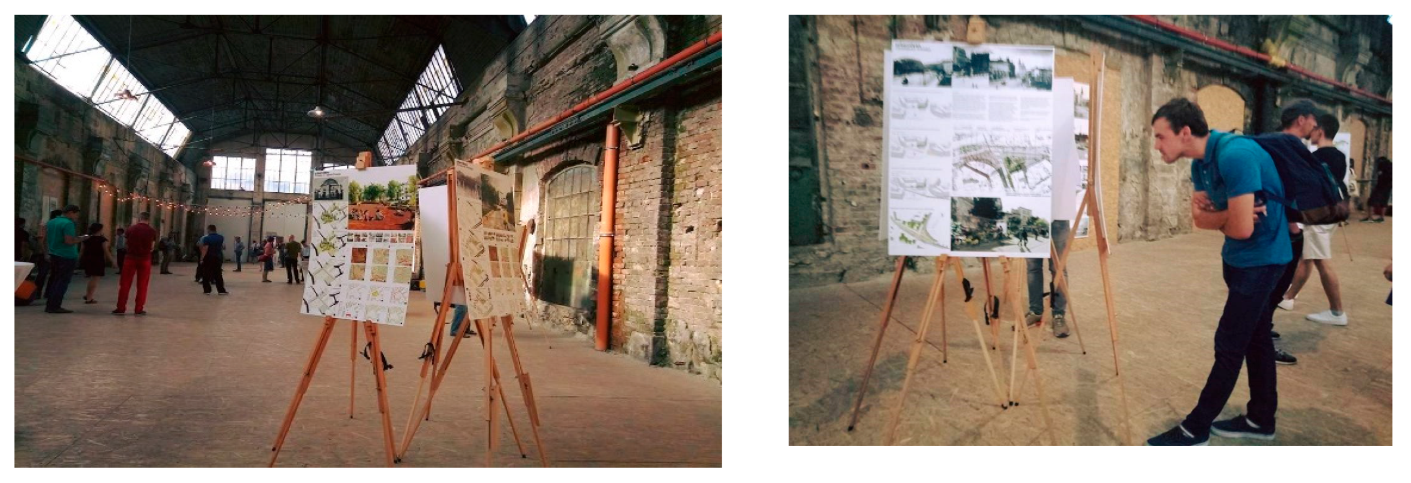
3.1.2. Halychsklo Plant (Halychglass)—“!FEST Republic”
3.1.3. Tram Depot of Sakharov and Vitovsky Streets—Lem Station
3.2. Model 2: Revalued Multifunctional Areas
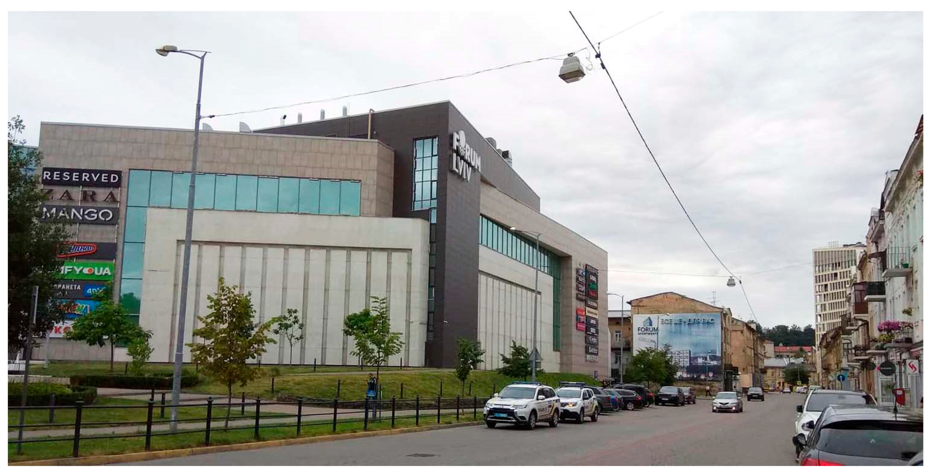
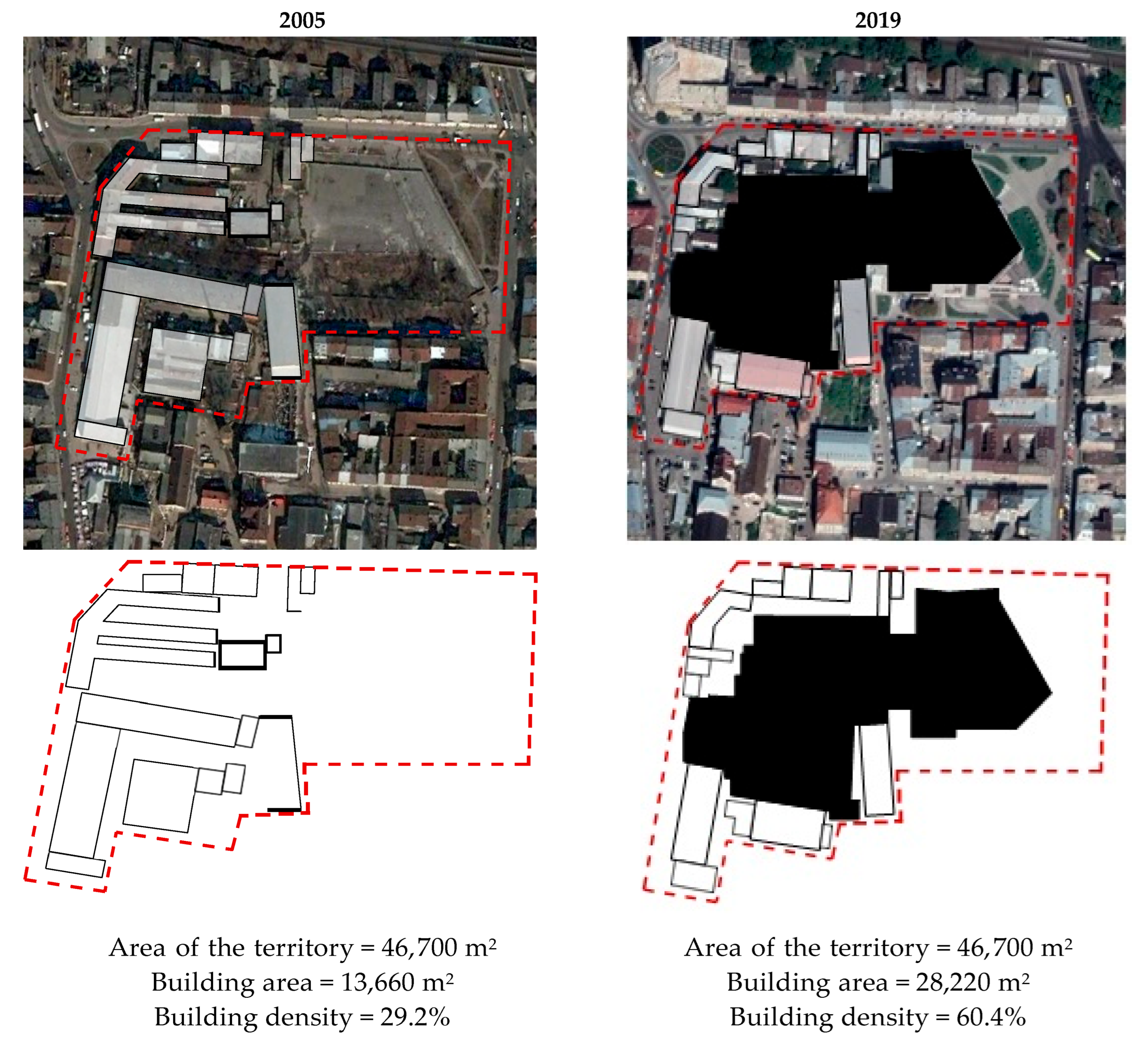
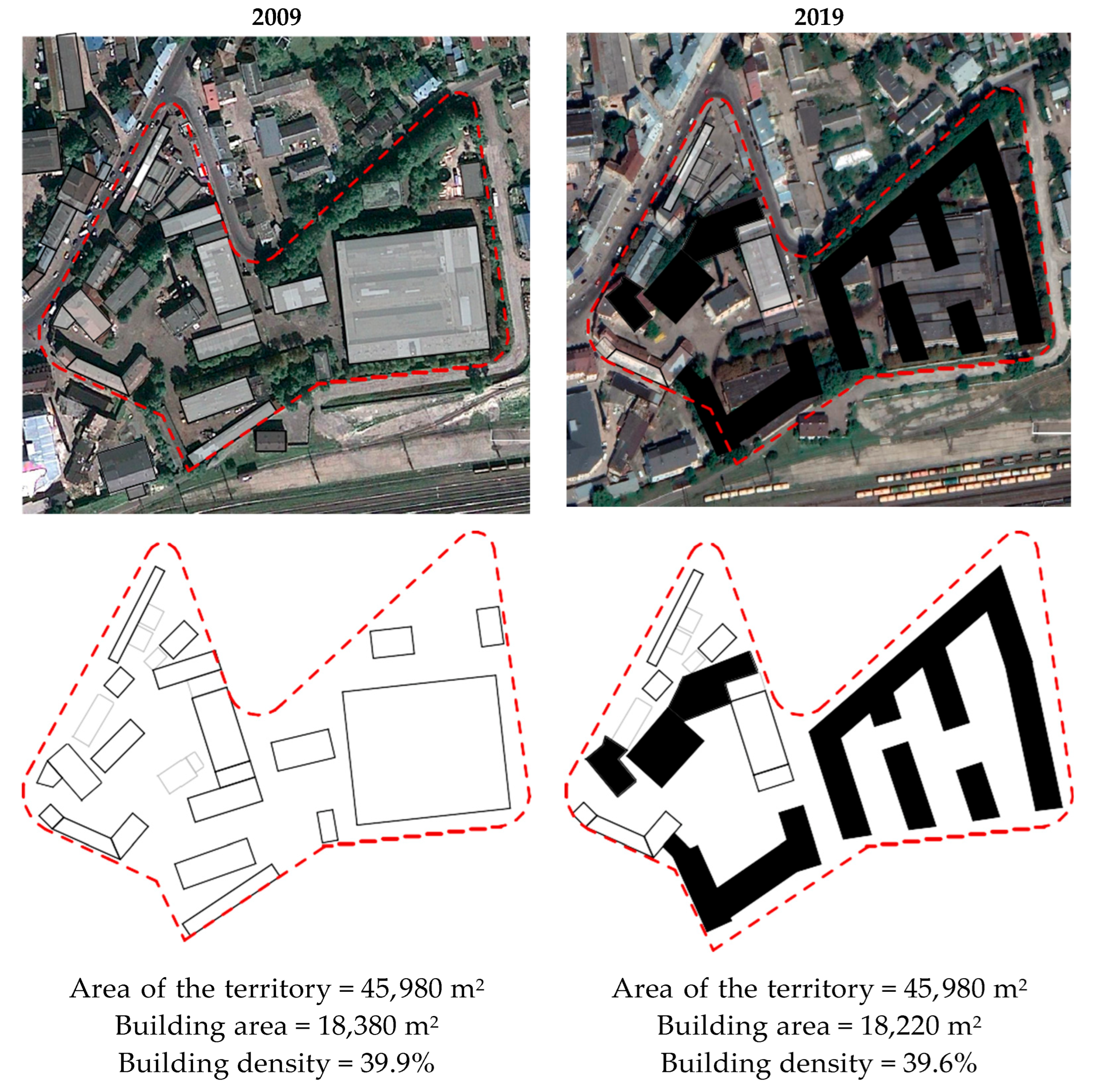
Gas Equipment Plant—FORUM
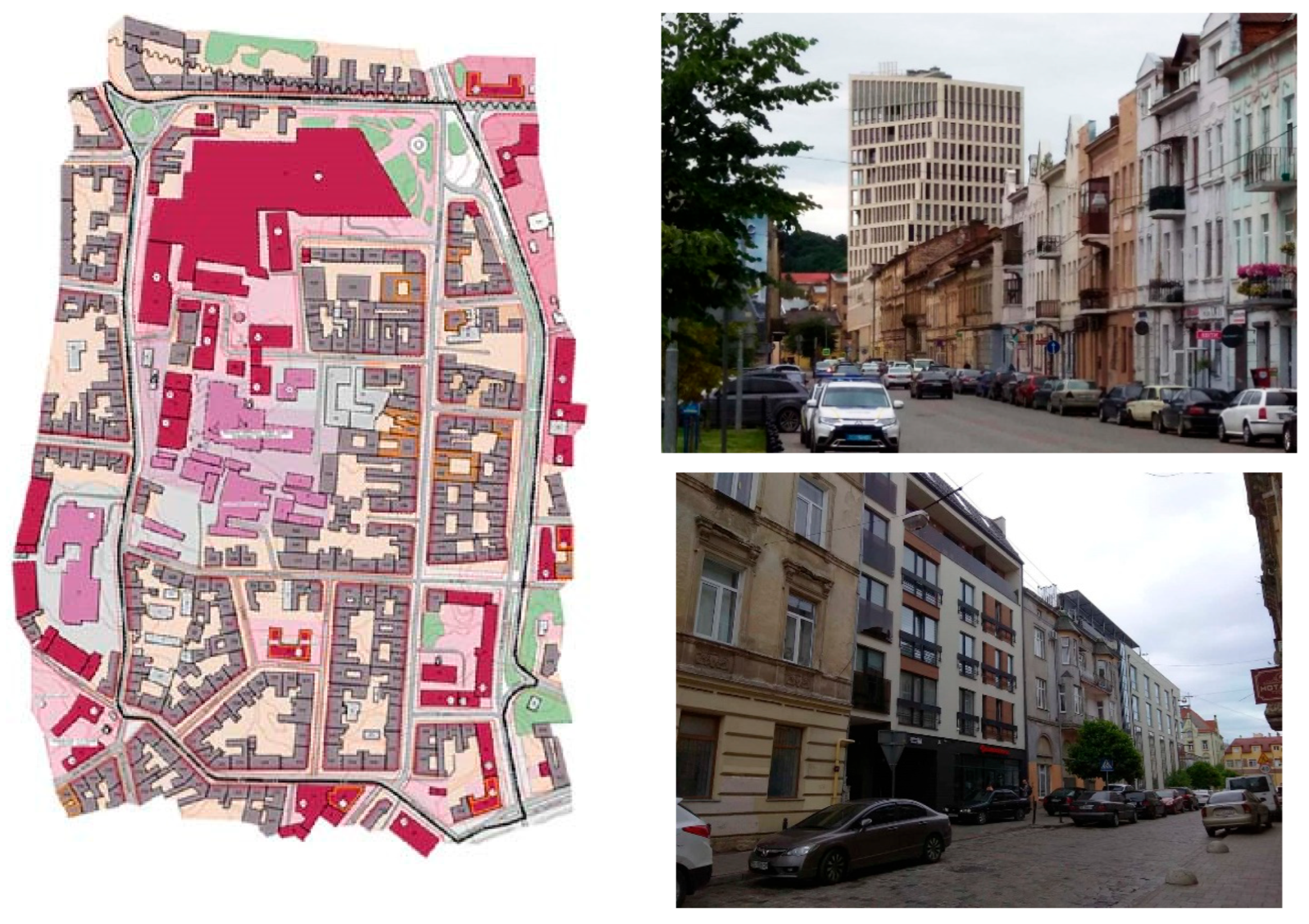
3.3. Model 3: Implementation of the Concept of City Center Expansion
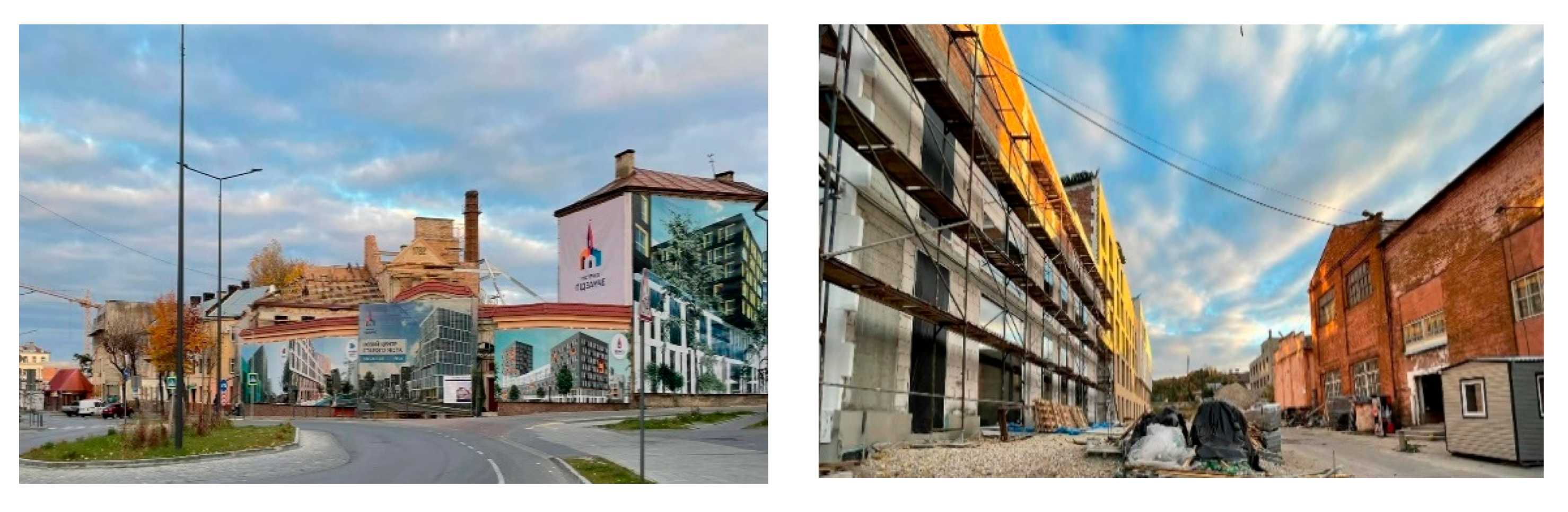
Former H. Blumenfeld Varnishing and Painting Factory—Quarter “Avalon”
3.4. Model 4: Reconstruction of Historical Localities
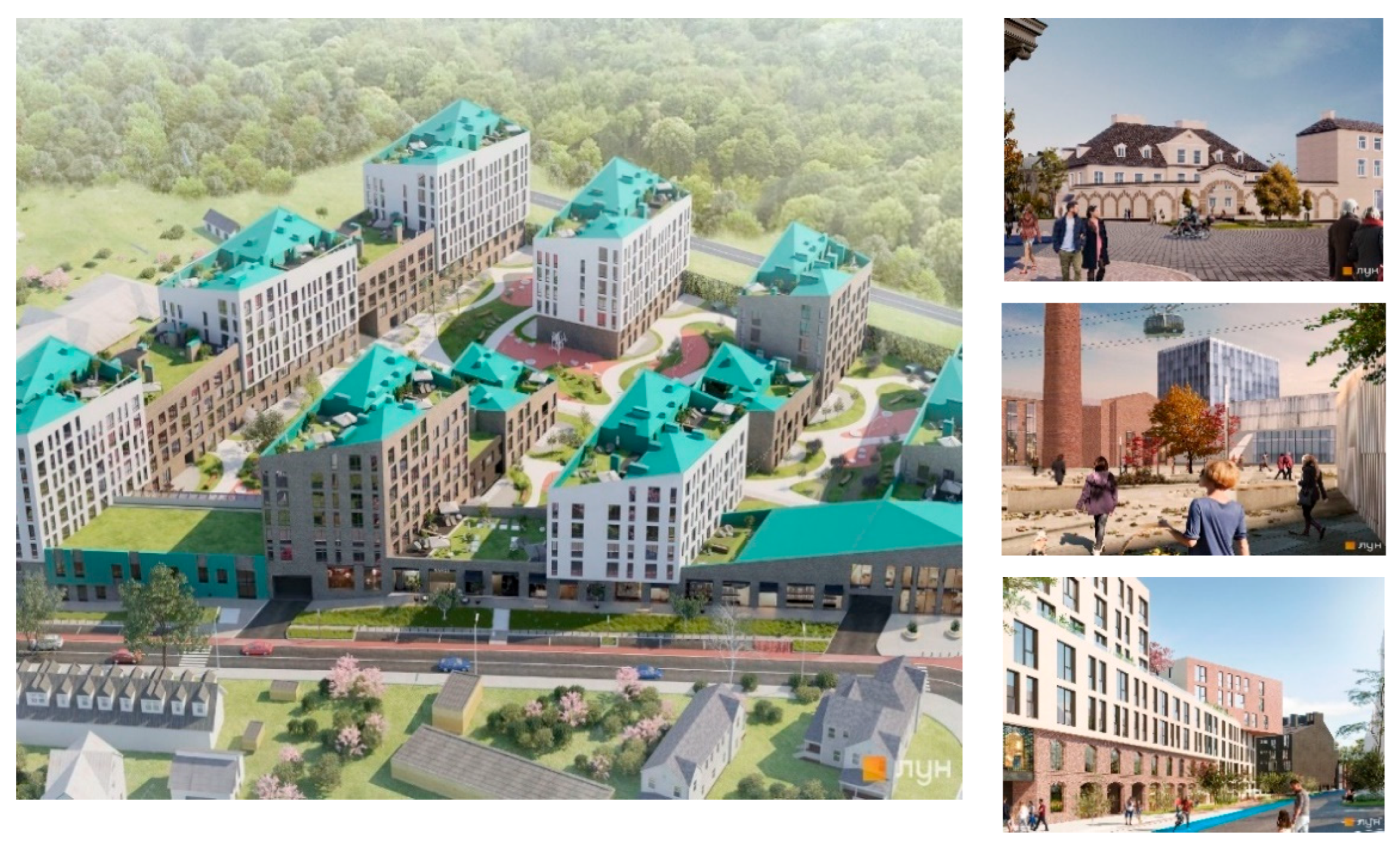
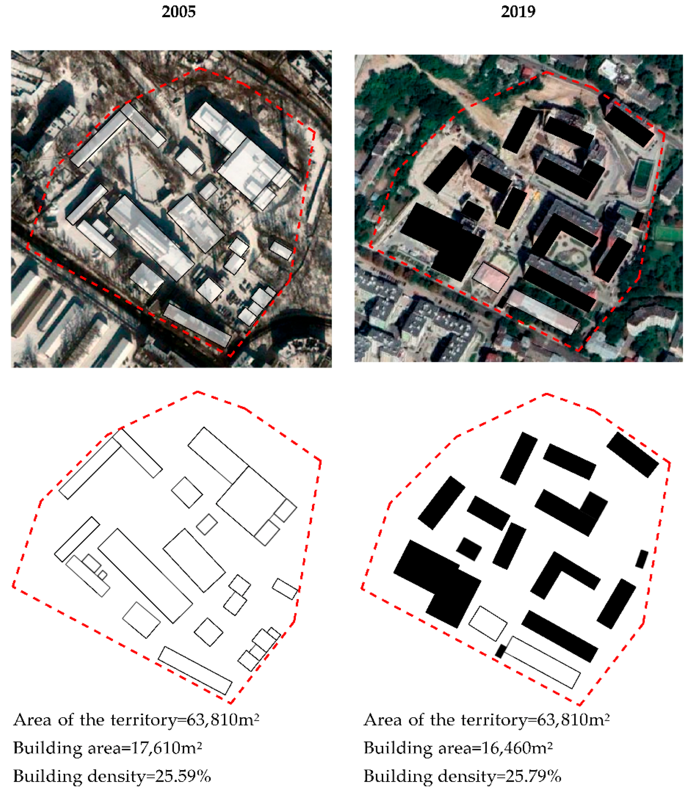
The Example of Pidzamche Sites in the Locality of B. Khmelnytsky Street (Plant Almazinstrument—“Pidzamche Town”)
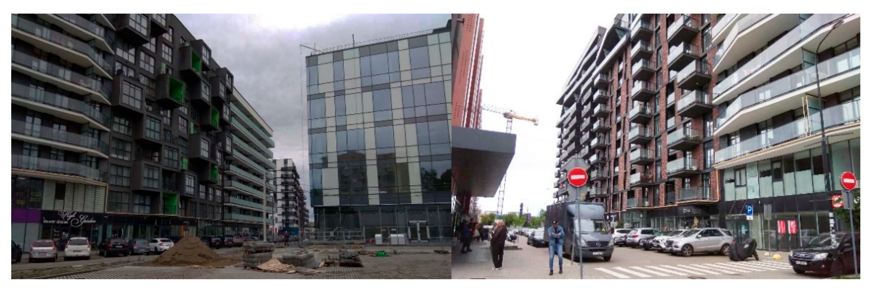
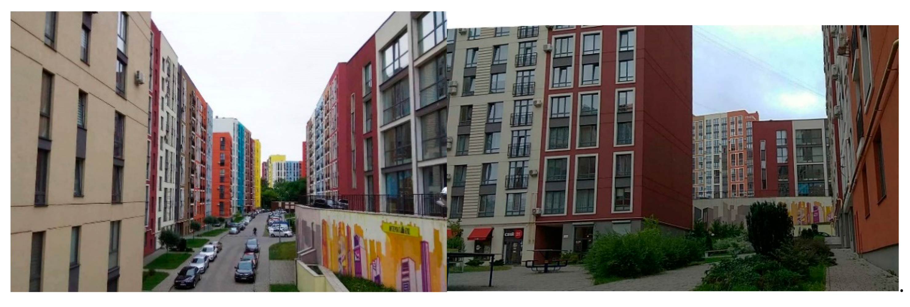
3.5. Model 5: Creation of New Residential Complexes
Glas Fabric = “Semitsvit” Residential Area

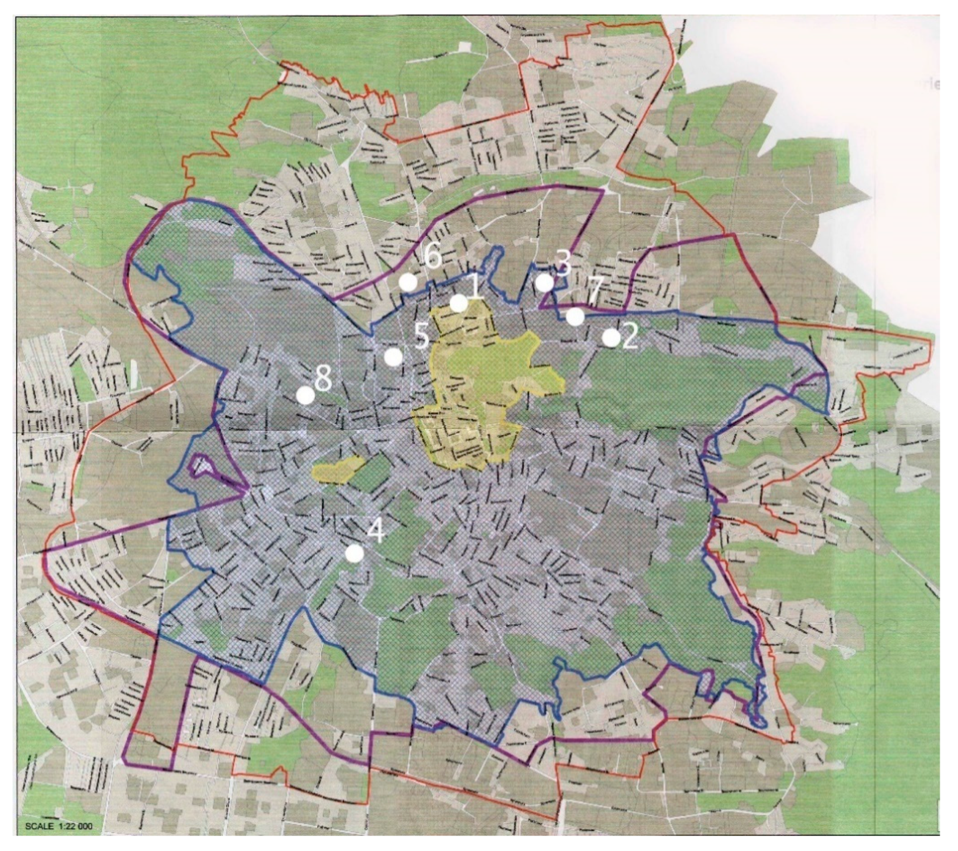
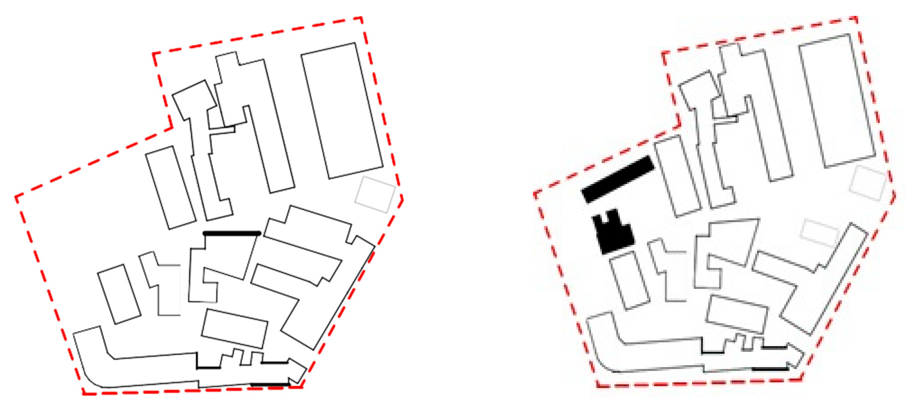
| Postindustrial Objects and Territories | Does It Meet the Master Plan? | Does It Meet the New Development Strategy of the City? | Does It Meets the Need of Local Community/and the Whole City | Does It Fit to the Scale of the Particular City District? | Level of Preser-Vation of the Indus-Trial Heritage | |
|---|---|---|---|---|---|---|
| 1 | Plant REMA = ReZavod (Figure 3 and Figure 4) | + | + | +/+ | + | Full |
| 2 | Plant Halychsklo (Halychglass)—“FEST republic” (Figure 5) | + | +/+ | + | Full | |
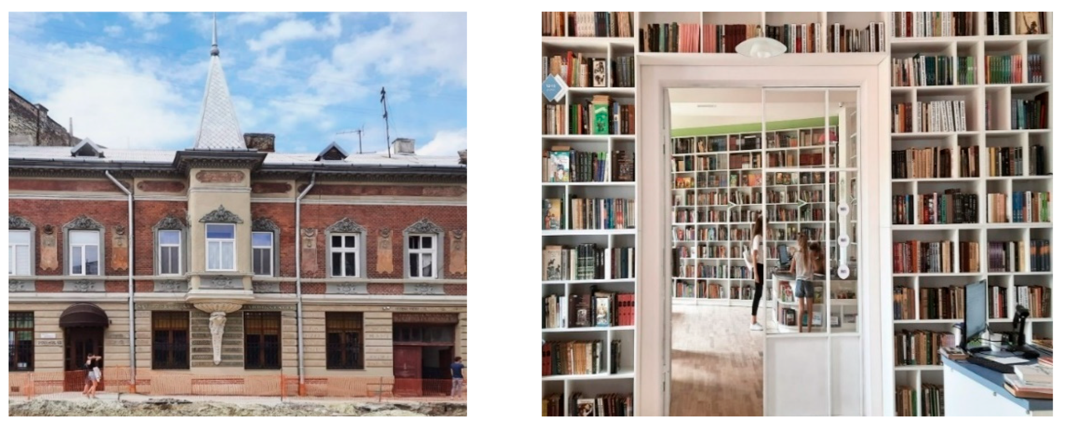
| 3 | The administrative building of the former Jam factory = children’s library (Figure 6) | + | +/ | + | Full | |
| 4 | Tram depot = Lem Station (Figure 7) | + | /+ | + | Full | |
| 5 | Gas equipment plant = multifunctional area by Dzherelna Street (Figure 8, Figure 9, Figure 10 and Figure 11) | + | + | /+ | + | Partial |
| 6 | G. Blumenfeld Varnishing and Painting Factory = Chornovil-Lypynskyj-Khimichna, quarter “Avalon” (Figure 12 and Figure 13) | Partially | + | /+ | + | Mini-mum |
| 7 | Baczewski liquer fabric (Almazinstrument) = residental area “Pidzamche Town” (Figure 14, Figure 15 and Figure 16) | Partially | + | /+ | + | Satisfactory |
| 8 | Glas fabric = Semitsvit residential area (Figure 18 and Figure 19) | /Partially | Minimum |
4. Discussion
5. Conclusions
- The development of the creative industry—objects that were important for urban city development and had valuable architectural features are subjected to adaptive reconstruction, mainly as a quick response to the city’s request;
- The revalued multifunctional areas—the more valuable postindustrial heritage is preserved, which plays the role of a landmark, and new buildings are constructed on the vacated territory;
- The implementation of the concept of city center expansion—these postindustrial areas are intensively rebuilt in the places where the general city functions are accumulating;
- The reconstruction of historical localities—multiple approaches are used with respect to new functional purposes, but the solution to the housing problem remains the top priority;
- The creation of new residential complexes—the low-value postindustrial heritage is not preserved, and the functional and planning integration of the new buildings with the surroundings and a significant rise in the urban density is planned.
Author Contributions
Funding
Institutional Review Board Statement
Informed Consent Statement
Conflicts of Interest
References
- Report of the Cabinet of Ministers of Ukraine on the Status of Implementation of the General Scheme of Territory Planning of Ukraine for 2018. Available online: https://www.minregion.gov.ua/wp-content/uploads/2020/01/Monitoring-GSPTU-za-2018-rik.pdf (accessed on 2 August 2022).
- Pidgrushnyi, G. Formation of growth poles system in Ukraine as a precondition to its transition to the model of poly-centric spatial development. Ukr. Geogr. J. 2017, 1, 48–54. [Google Scholar] [CrossRef]
- Department of Architecture and Urbanism of the Lviv City Council, Institute of the City (2021) Integrated Concept of Development: Lviv 2030. Available online: https://drive.google.com/drive/folders/12Mz6HnLRvtUzZW0NnKGm1lPgI1BShEVG?fbclid=IwAR2yvg1X44ta9C0-uMsmG_GBTZoFALijELZuTgdeuz9m9W-Ex22MNoIAiqU (accessed on 4 August 2022).
- Koshelyuk, M.; Toman, U. Development of Ukrainian Cities: New Boundaries—New Opportunities. Available online: https://mistosite.org.ua/articles/rozvytok-ukrainskykh-mist-novi-merezhi-novi-mozhlyvosti (accessed on 2 August 2022).
- Integrated Development Concepts. Department of Architecture and Urbanism of the Lviv City Council. Available online: http://www.urban-project.lviv.ua/ua/gtz-projects/intehrovanyj-rozvytok-mista/intehrovani-koncepcii-rozwytku (accessed on 3 August 2022).
- Kolomeytsev, A. Information Note to the Decision of the Lviv City Council “On Approval of the Integrated Concept of Development: Lviv 2030”. Available online: https://drive.google.com/drive/u/0/folders/12Mz6HnLRvtUzZW0NnKGm1lPgI1BShEVG (accessed on 3 August 2022).
- Petryshyn, H.; Lyubytsky, R. Significance of the “Project of Detailed Planning of the Central Part of Lviv” in 1970 in the Formation of the Modern City; Andrii Rudnytskyy: Architectural portrait on the background of the era; Cherkes, B., Ed.; Lviv Polytechnic Publishing House: Lviv, Ukraine, 2019; pp. 57–69. [Google Scholar]
- Couch, C. Urban Renewal: Theory and Practice; Macmillan: London, UK, 1990. [Google Scholar]
- Roberts, P.; Granger, R.; Sykes, H. Urban Regeneration; Sage Publications: New Deli, India, 2016. [Google Scholar]
- Yıldız, S.; Kıvrak, S.; Gültekin, A.B.; Arslan, G. Built environment design—Social sustainability relation in urban renewal. Sustain. Cities Soc. 2020, 60, 102173. [Google Scholar] [CrossRef]
- Van der Ark, T. How Cities Are Getting Smart Using Artificial Intelligence. Forbes. 2018. Available online: https://www.forbes.com/sites/tomvanderark/2018/06/26/how-cities-are-getting-smart-using-artificial-intelligence/?sh=2cebc66a3803 (accessed on 3 August 2022).
- Greengard, S. The Internet of Things; MIT Press: Oxford, MI, USA, 2015. [Google Scholar]
- Jun, S.; Kochan, O. The mechanism of the occurrence of acquired thermoelectric inhomogeneity of thermocouples and its effect on the result of temperature measurement. Meas. Tech. 2015, 57, 1160–1166. [Google Scholar] [CrossRef]
- Hu, Z.; Gnatyuk, S.; Okhrimenko, T.; Tynymbayev, S.; Iavich, M. High-speed and secure PRNG for cryptographic applications. Int. J. Comput. Netw. Inf. Secur. 2020, 12, 1–10. [Google Scholar] [CrossRef]
- Jun, S.; Kochan, O.; Kochan, R. Thermocouples with built-in self-testing. Int. J. Thermophys. 2016, 37, 37. [Google Scholar] [CrossRef]
- Wójcik, A.; Bilski, P.; Łukaszewski, R.; Dowalla, K.; Kowalik, R. Identification of the State of Electrical Appliances with the Use of a Pulse Signal Generator. Energies 2021, 14, 673. [Google Scholar] [CrossRef]
- Hu, Z.; Tereikovskyi, I.; Chernyshev, D.; Tereikovska, L.; Tereikovskyi, O.; Wang, D. Procedure for processing biometric parameters based on wavelet transformations. Int. J. Mod. Educ. Comput. Sci. 2021, 13, 11–22. [Google Scholar] [CrossRef]
- Klemek, C. The Transatlantic Collapse of Urban Renewal, Postwar Urbanism from New York to Berlin; University of Chicago Press: Chicago, IL, USA, 2011. [Google Scholar]
- Mouratidis, K. Urban planning and quality of life: A review of pathways linking the built environment to subjective well-being. Cities 2021, 115, 103229. [Google Scholar] [CrossRef]
- Çevik, S.; Vural, S.; Tavşan, F.; Aşık, Ö. An example to renovation–revitalization works in historical city centres: Kundura-cılar Street/Trabzon-Turkey. Build. Environ. 2008, 43, 950–962. [Google Scholar] [CrossRef]
- İpekoğlu, B. An architectural evaluation method for conservation of traditional dwellings. Build. Environ. 2006, 41, 386–394. [Google Scholar] [CrossRef]
- Loures, L. Post-industrial landscapes as drivers for urban redevelopment: Public versus expert perspectives towards the benefits and barriers of the reuse of post-industrial sites in urban areas. Habitat Int. 2015, 45, 72–81. [Google Scholar] [CrossRef]
- Čurović, Ž.; Čurović, M.; Spalević, V.; Janic, M.; Sestras, P.; Popović, S.G. Identification and Evaluation of Landscape as a Precondition for Planning Revitalization and Development of Mediterranean Rural Settlements—Case Study: Mrkovi Village, Bay of Kotor, Montenegro. Sustainability 2019, 11, 2039. [Google Scholar] [CrossRef]
- Nowysz, A. Modernist Projects of Community-Based Urban Farms in Residential Areas—A Review of Agrarian Cooperatives in the Context of Contemporary Urban Development. Buildings 2021, 11, 369. [Google Scholar] [CrossRef]
- Lin, M.; Jian, J.; Yu, H.; Zeng, Y.; Lin, M. Research on the Spatial Pattern and Influence Mechanism of Industrial Transformation and Development of Traditional Villages. Sustainability 2021, 13, 8898. [Google Scholar] [CrossRef]
- Mayowa, I.A.; Joseph, H.L.; Edwin, H.C.; Amos, D.A. Heritage building maintenance management (HBMM): A bibliometric-qualitative analysis of literature. J. Build. Eng. 2021, 42, 102416. [Google Scholar]
- Guimarães, P. Business Improvement Districts: A Systematic Review of an Urban Governance Model towards City Center Revitalization. Land 2021, 10, 922. [Google Scholar] [CrossRef]
- Nkonki-Mandleni, B.; Omotayo, A.O.; Ighodaro, D.I.; Agbola, S.B. Analysis of the Living Conditions at eZakheleni Informal Settlement of Durban: Implications for Community Revitalization in South Africa. Sustainability 2021, 13, 2371. [Google Scholar] [CrossRef]
- Knippschild, R.; Zöllter, C. Urban Regeneration between Cultural Heritage Preservation and Revitalization: Experiences with a Decision Support Tool in Eastern Germany. Land 2021, 10, 547. [Google Scholar] [CrossRef]
- Taraszkiewicz, A. Revitalization of Residential Buildings Dating Back to the Late 19th and Early 20th Century on the Example of “Willa Halina” in Sopot (Poland). Buildings 2021, 11, 279. [Google Scholar] [CrossRef]
- Zielińska-Szczepkowska, J.; Jaszczak, A.; Žukovskis, J. Overcoming Socio-Economic Problems in Crisis Areas through Re-vitalization of Cittaslow Towns. Evidence from North-East Poland. Sustainability 2021, 13, 7984. [Google Scholar] [CrossRef]
- The UNESCO Recommendation on the Historic Urban Landscape. Report of the Second Consultation on Its Implementation by Member States 2019; UNESCO World Heritage Centre: Paris, France, 2019; 319p. [Google Scholar]
- Bandarin, F.; van Oers, R. The Historic Urban Landscape: Managing Heritage in an Urban Century; John Wiley & Sons: Hoboken, NJ, USA, 2012; p. 98. [Google Scholar]
- Bandarin, F.; van Oers, R. (Eds.) Reconnecting the City: The Historic Urban Landscape Approach and the Future of Urban Heritage; John Wiley & Sons: Hoboken, NJ, USA, 2014. [Google Scholar] [CrossRef]
- Colavitti, A.M. Urban Heritage Management: Planning with History; Springer: Cham, Switzerland, 2018. [Google Scholar] [CrossRef]
- Choay, F. La Règle et le Modèle; Média Diffusion: Paris, France, 2019. [Google Scholar]
- Rodwell, D. Reconnecting the city: The historic landscape approach and the future of urban heritage. J. Archit. Conserv. 2015, 21, 136–138. [Google Scholar] [CrossRef]
- Rossi, C.; Rabie, S. Towards the Egyptian charter for conservation of cultural heritages. J. Contemp. Urban Aff. 2021, 5, 101–111. [Google Scholar] [CrossRef]
- Hussein, N. Adaptive reuse of the industrial building: A case of energy museum in Sanatistanbul, Turkey. J. Contemp. Urban Aff. 2017, 1, 24–34. [Google Scholar] [CrossRef]
- Yildiz, G.; Şahin Güçhan, N. An industrial heritage case study in Ayvalık: Ertem olive oil factory. J. Contemp. Urban Aff. 2018, 2, 20–30. [Google Scholar] [CrossRef]
- Lviv—The Ensemble of the Historic Centre. Available online: https://whc.unesco.org/en/list/865 (accessed on 2 August 2022).
- Ponomaryova, A.; Ryan, B.D. Will Kyiv’s soviet industrial districts survive? A study of transformation, preservation, and demolition of industrial heritage in Ukraine’s capital. J. Plan. Hist. 2020, 20, 220–268. [Google Scholar] [CrossRef]
- Dixon, T.; Montgomery, J.; Horton-Baker, N.; Farrelly, L. Using urban foresight techniques in city visioning: Lessons from the Reading 2050 vision. Local Econ. 2018, 33, 777–799. [Google Scholar] [CrossRef]
- Knox, P.L. Cities and Design; Routledge: London, UK, 2011. [Google Scholar]
- Ouředníček, M.; Šimon, M.; Kopečná, M. The reurbanisation concept and it’s utility for contemporary research on post-socialist cities: The case of Czech Republic. Morav. Geogr. Rep. 2015, 23, 26–35. [Google Scholar]
- Wu, X. Productive Landscape: Revitalizing a Post-Industrial District with Slow Economy. Master’s Thesis, Landscape Architecture in Landscape Architecture in the Graduate College of the University of Illinois at Urbana-Champaign, Urbana, IL, USA, 2011; 63p. [Google Scholar]
- Standards and Guidelines for the Conservation of Historic Places in Canada. A Federal, Provincial and Territorial Collaboration. Second Edition. Catalogue Number R62-343/2010E-PDF. 2019. Available online: https://www.historicplaces.ca/media/7209/sandg_en.pdf (accessed on 11 August 2022).
- Lemes de Oliveira, F.; Farrelly, L. The regeneration of a naval city: Portsmouth. In Parallel Patterns of Shrinking Cities and Urban Growth: Spatial Planning for Sustainable Development of City Regions and Rural Areas; Ganser, R., Ed.; Ashgate: London, UK, 2012; pp. 245–256. [Google Scholar]
- Hatuka, T.; Rosen-Zvi, I.; Birnhack, M.; Toch, E.; Zur, H. The political premises of contemporary urban concepts: The global city, the sustainable city, the resilient city, the creative city, and the smart city. Plan. Theory Pract. 2018, 19, 160–179. [Google Scholar] [CrossRef]
- Petryshyn, H. Budowa Tożsamości Szczecina w Oparciu o Wykorzystanie Kulturowych Wartości Krajobrazu Nadrzecznego Miasta; Petryshyn, H., Czałczynska-Podolska, M., Sochacka-Sutkowska, E.A., Pilarczyk, A., Eds.; Hogben: Szczecin, Poland, 2012. [Google Scholar]
- Vainio, T.H. Building renovation: A new industry? In Proceedings of the Management and Innovation for a Sustainable Built Environment MISBE 2011, Amsterdam, The Netherlands, 20–23 June 2011; p. 85. [Google Scholar]
- Cherkes, B.; Linda, S. Rebirth of multicultural identity in public spaces of Lviv. IOP Conf. Ser. Mater. Sci. Eng. 2019, 471, 072019. [Google Scholar] [CrossRef]
- Steinberg, F. Revitalization of Historic Inner-City Areas in Asia. In The Potential for Urban Renewal in Ha Noi, Jakarta, and Manila; Asian Development Bank: Manila, Philippines, 2008. [Google Scholar]
- Muszynska-Jeleszynska, D.; Jasinska, M. Rewitalizacja terenów poprzemysłowych w Europie Środkowej—doświadczenia projektu COBRAMAN. Probl. Rozw. Miast 2013, 10, 95–104. [Google Scholar]
- Chmielewska, M.; Otto, M. The impact of revitalization on the evolution of urban space on former iron and steel works areas in Ruhr region (Germany). Environ. Socio-Econ. Stud. 2013, 1, 31–37. [Google Scholar] [CrossRef]
- Grodach, C.; Ehrenfeucht, R. Urban. Revitalization: Remaking Cities in a Changing World; Routledge: New York, NY, USA, 2016. [Google Scholar]
- Nikolić, I. Urban recycling of derelict industrial sites. In Analysis of Socio-Economic Redevelopment of Post-Industrial Districts; Máster Universitario en Gestión y Valoración Urbana, Universidad Politécnica de Cataluña: Barcelona, Spain, 2014. [Google Scholar]
- Sosnova, N.; Wilkosz-Mamcarczyk, M. Developing “green” public spaces as a path to urban revitalisation of residential-industrial zones. Geomat. Landmanagement Landsc. 2017, 4, 95–104. [Google Scholar] [CrossRef]
- Zagroba, M. Issues of the Revitalization of Historic Centres in Small Towns in Warmia. Procedia Eng. 2016, 161, 221–225. [Google Scholar] [CrossRef][Green Version]
- Berens, C. Redeveloping Industrial Sites: A Guide for Architects Developers and Planners; Whiley & Sons: Hoboken, NJ, USA, 2011. [Google Scholar]
- Taylor, N. Urban Planning Theory Since 1945; SAGE: Los Angeles, CA, USA, 1998. [Google Scholar]
- Rosen, M.; Sullivan, W. From Urban Renewal and Displacement to Economic Inclusion: San Francisco Affordable Housing Policy 1978–2012; Stanford University: Stanford, CA, USA, 2012. [Google Scholar]
- Stone, S. Foreword. In Adaptive Reuse of the Built Heritage. Concepts and Cases of an Emerging Discipline; Plevoets, B., Van Cleempoel, K., Eds.; Routledge: Abingdon, UK, 2019; pp. 17–19. [Google Scholar]
- Yin, R.K. Case Study Research Design and Methods, 5th ed.; Sage: Thousand Oaks, CA, USA, 2014. [Google Scholar]
- Bartik, T.J. The revitalization of older industrial cities: A review essay of retooling for growth. Growth Chang. 2009, 40, 1–29. [Google Scholar] [CrossRef]
- Maluszynska, I.; Maluszynski, M.J.; Ancuta, M. Revitalization of post-industrial areas of the capital city of Warsaw on the example of Powisle. Sci. Rev. Eng. Env. Sci. 2014, 63, 99–109. [Google Scholar]
- Brezden, P.; Szmytkie, R. Current changes in the location of industry in the suburban zone of a post-socialist city. Case study of Wrocław (Poland). Tijds. Econ. Soc. Geog. 2019, 110, 102–122. [Google Scholar] [CrossRef]
- Kuzior, A.; Grebski, W.; Kwilinski, A.; Krawczyk, D.; Grebski, M.E. Revitalization of Post-Industrial Facilities in Economic and Socio-Cultural Perspectives—A Comparative Study between Poland and the USA. Sustainability 2022, 14, 11011. [Google Scholar] [CrossRef]
- Golovanov, E.B.; Kiseleva, V.A. Evolution of re-development as a trend in transformation of urban territories. Bull. South Ural. State Univ. Ser. Econ. Manag. 2013, 3, 12–16. [Google Scholar]
- Klopotowski, M.; Zagroba, M. Post-industrial Objects and Buildings in the Structure of the Contemporary City, World Mul-tidisciplinary Earth Sciences Symposium (WMESS 2017). IOP Publ. IOP Conf. Ser. Earth Environ. Sci. 2017, 95, 052019. [Google Scholar] [CrossRef]
- Jadach-Sepioło, A.; Muszyńska-Jeleszyńska, D.; Spadło, K. Analysis of the Current Situation of Post-Industrial Sites in Urban Areas of Three Functional Zones: Capital City of Warsaw, the City of Plock and the City of Radom together with the City of Pionki. Interreg. Central Eur. ReSites, Version 1; 2016. Available online: https://www.interreg-central.eu/Content.Node/ReSites/WPT1--GreenerSites-Brownfield-analysis-of-Radom-and-Plock-FU.pdf (accessed on 4 August 2022).
- Pedko, I.; Pandas, A. Revitalization of Industrial Zones of The Big City. In Proceedings of the 32nd International Scientific Conference on Economic and Social Development, Odesa, Ukraine, 21–22 June 2018; pp. 174–180. [Google Scholar]
- Gyurkovich, M.; Gyurkovich, J. New Housing Complexes in Post-Industrial Areas in City Centres in Poland Versus Cultural and Natural Heritage Protection—With a Particular Focus on Cracow. Sustainability 2021, 13, 418. [Google Scholar] [CrossRef]
- Syms, P. Land, Development and Design, 2nd ed.; Wiley-Blackwell: Oxford, MI, USA, 2010. [Google Scholar]
- Yigitcanlar, T.; Dizdaroglu, D. Ecological approaches in planning for sustainable cities. Glob. J. Environ. Sci. Manag. 2015, 2, 159–188. [Google Scholar]
- Kvaterniuk, S.; Petruk, V.; Kochan, O.; Frolov, V. Multispectral ecological control of parameters of water environments using a quadrocopter. Studies in Systems, Decision and Control. In Volume. 198: Sustainable Production: Novel Trends in Energy, Environment and Material Systems; Królczyk, G., Wzorek, M., Król, A., Kochan, O., Su, J., Kacprzyk, J., Eds.; Springer: Cham, Switzerland, 2020; pp. 75–89. [Google Scholar] [CrossRef]
- Dmytrik, N.; Urenev, V. Industrial architecture of Odessa from the context of renovation of industrial objects. Electron. J. Fac. Civ. Eng. Osijek-e-GFOS 2020, 11, 25–38. [Google Scholar] [CrossRef]
- Shyshkin, E.; Viatkin, K.; Haiko, Y. Basic methodical design stages of renovation of municipal industrial development. ICCATS 2020. IOP Conf. Ser. Mater. Sci. Eng. 2020, 962, 032055. [Google Scholar] [CrossRef]
- Clark, G.; Moonen, T.; Nunley, J. The Story of Your City: Europe and Its Urban Development, 1970 to 2020; European Investment Bank. 2019. Available online: https://www.eib.org/en/essays/the-story-of-your-city (accessed on 3 August 2022).
- Sadowy, K.; Lisiecki, A. Post-industrial, post-socialist or new productive city? Case study of the spatial and functional change of the chosen Warsaw industrial sites after 1989. City Territ. Archit 2019, 6, 4. [Google Scholar] [CrossRef]
- Konior, A.; Pokojska, W. Management of Postindustrial Heritage in Urban Revitalization Processes. Sustainability 2020, 12, 5034. [Google Scholar] [CrossRef]
- National Report “Goals of Sustainable Development of Ukraine Provides the Vision of Achieving by Ukraine Goals of Sustainable Development (by 2030), Approved at the Summit of United Nations on Sustainable Development in 2015. Available online: https://cutt.ly/JLFQdOA (accessed on 2 August 2022).
- Nazaruk, M.M.; Polianskiy, Y.S. Revitalization processes of changing geospatial in European cities. Visnyk of V. N. Karazin Kharkiv Natl. Univ. Ser. Ecol. 2019, 21, 34–50. [Google Scholar] [CrossRef]
- Adabre, M.A.; Chan, A.P.; Edwards, D.J.; Osei-Kyei, R. To build or not to build, that is the uncertainty: Fuzzy synthetic evaluation of risks for sustainable housing in developing economies. Cities 2022, 125, 103644. [Google Scholar] [CrossRef]
- Hürlimann, A.C.; Warren-Myers, G.; Nielsen, J.; Moosavi, S.; Bush, J.; March, A. Towards the transformation of cities: A built environment process map to identify the role of key sectors and actors in producing the built environment across life stages. Cities 2022, 121, 103454. [Google Scholar] [CrossRef]
- Master Plan of the City of Lviv. 1966. Ukrainian State Institute of Urban Planning “Giprohrad”.
- Rusanova, I.V. Shaping functional plans of monocentric urban agglomerations of the 60–80-s of the XX century (on the example of the Lviv agglomeration). 2015 L’viv Rastr-7. Available online: https://scholar.google.com.ua/citations?view_op=view_citation&hl=uk&user=upcu1l8AAAAJ&sortby=pubdate&citation_for_view=upcu1l8AAAAJ:roLk4NBRz8UC (accessed on 11 August 2022). (In Ukrainian).
- Detailed Planning Project of the Central Part of Lviv; Lviv Branch of “Giprograd”: Lviv, Ukraine, 1970.
- Bevz, M. Transport and functional prerequisites for the regeneration of the central historical area of Lviv. In Urban and Architectural Problems of the Cities of Galychyna; Cherkes, B., Bevz, M., Eds.; State University “Lviv Polytechnic”: Lviv, Ukraine, 1996. [Google Scholar]
- Resolution of the Session of the Lviv Regional Council of 8 December 2009. Available online: https://cutt.ly/QEU2q4Z (accessed on 2 August 2022).
- Adjustment of the Master Plan of Lviv. Stage 2: Master Plan. Volume 3. Basic Provisions. Lviv. 2008. Available online: https://www.city-adm.lviv.ua/lmr/images/stories/arhitect/123/01_genplan.pdf (accessed on 3 August 2022).
- Boundaries of the Historic Area of the City of Lviv. 2005. Available online: https://whc.unesco.org/en/documents/102471 (accessed on 2 August 2022).
- The Law of Ukraine “On Regulation of Urban Development Activities”. Available online: https://cis-legislation.com/document.fwx?rgn=32960 (accessed on 2 August 2022).
- The Map of Detailed Plans and Public Discussions. Available online: https://www.lvivrada.gov.ua/informacia/plany (accessed on 2 August 2022).
- Integrated Concept of Development of the Central Part of Lviv. 2011. Available online: http://www.urban-project.lviv.ua/php_uploads/data/articles/ArticleFiles_UA_182.pdf (accessed on 2 August 2022).
- State Building Codes of Ukraine. Planning and Construction of DBN Territories B.2.2-12: 2019. Kyiv. 2019. Available online: https://dreamdim.ua/wp-content/uploads/2019/07/DBN-B22-12-2019.pdf (accessed on 5 August 2022).
- One Day in the Life of the Renovated Lviv Plant REMA, Photo Report. 032.ua. Lviv City Website (uk-UA). Available online: https://www.032.ua/news/2443919/odin-den-iz-zitta-onovlenogo-lvivskogo-zavodu-rema-fotoreportaz (accessed on 4 August 2022).
- !FESTREPUBLIC: How One More Town Is Being Built on the Place of the Plant. Available online: https://tvoemisto.tv/exclusive/festrepublic_yak_u_lvovi_buduyut_shche_odne_misto_78042.html (accessed on 2 August 2022).
- Bell, D.; Binnie, J. What’s eating Manchester? Gastro-culture and urban regeneration. Archit. Des. 2005, 75, 78–85. [Google Scholar] [CrossRef]
- Creative Lviv: How Plants and Parks Develop the City. Available online: https://lviv1256.com/wheretogo/kreatyvnyj-lviv-yak-zavody-i-parky-rozvyvayut-misto/ (accessed on 2 August 2022).
- !Fest Republic. Available online: https://www.facebook.com/FESTrepublic/photos/a.1506472662892786/1506479766225409/?type=3 (accessed on 2 August 2022).
- Change, Creating Opportunities. Available online: http://lemstation.com/ (accessed on 4 August 2022).
- Urbanideas. Instagram. Available online: https://www.instagram.com/urbanideas/ (accessed on 2 August 2022).
- Tram Depot. Available online: https://tvoemisto.tv/exclusive/lem_station_yakym_bude_kreatyvnyy_prostir_u_staromu_tramvaynomu_depo_83843.html (accessed on 4 August 2022).
- Senkovska, Y. The tendencies of industrial restructuring on the example of Lviv city. Space Form 2015, 24, 165–174. [Google Scholar]
- Shulyar, V.A. Evolution of the concept of territorial expansion of the center of Lviv in urban projects of the XX—Early XX centuries. XXI century. Bull. NULP Archit. 2019, 11, 123–140. [Google Scholar]
- Zhou, C.; Petryshyn, H.; Liubytskyi, R.; Kochan, O. Optimization of on-street parking in the historical heritage part of Lviv (Ukraine) as a prerequisite for designing the IoT smart parking system. Buildings 2022, 12, 865. [Google Scholar] [CrossRef]
- Mambetova, S. City Creative Role of Iconic New Buildings in the Process of Urbanization of the City. Master’s Thesis, Archives of the Department of Urban Planning Lviv Polytechnic National University, Lviv, Ukraine, 2019. [Google Scholar]
- Cherkes, B.; Petryshyn, H.; Konyk, S. Urbanizational Trends and Impulses in the Housing Consruction of Ukraine. IOP Conf. Ser. Mater. Sci. Eng. 2019, 471, 092058. [Google Scholar] [CrossRef]
- Forum. Available online: https://explorer.lviv.ua/forum/ (accessed on 2 August 2022).
- Available online: https://cutt.ly/tLFAGDh (accessed on 2 August 2022).
- Tchaikovsky, O.I. Concept and content of the constitutional right to housing. South Ukr. Law J. 2020, 4, 56–61. [Google Scholar] [CrossRef]
- Lun. Available online: https://cutt.ly/nLFACIz (accessed on 2 August 2022).
- Lviv City Council. Comprehensive Development Strategy of Lviv 2012–2025. 2011. Available online: https://www8.city-adm.lviv.ua/inteam/uhvaly.nsf/0/23349f49bc91ba52c225793400489747/$FILE/%D0%A1%D0%B5%D1%81%D1%96%D1%8F2.pdf (accessed on 2 August 2022).
- Hanets, S. Principles of Neighborhood Formation on Postindustrial Sites (on the Example of Lviv). Ph.D. Dissertation, Lviv Polytechnic National University, Lviv, Ukraine, 2018. Available online: https://lpnu.ua/sites/default/files/2020/dissertation/1575/cila-dysertacija-hanets-s-v.pdf (accessed on 2 August 2022).
- Lviv City Council, Decision № 1311 dated 09.12.2005. About the Statement of Borders of a Historical Area and a Zone of Regulation of Building of the City of Lviv, dod.1, 2005. Lviv: Lviv City Council. Available online: https://www8.city-adm.lviv.ua/Pool/Info/doclmr_1.NSF/(SearchForWeb)/458C3574D578DE2DC22570F5004FFF5D?OpenDocument (accessed on 2 August 2022).
- Hanets, S. Factors of formation of functional purpose of post-industrial territories. Mod. Probl. Archit. Urban Plan. 2017, 49, 293–299. [Google Scholar]


Publisher’s Note: MDPI stays neutral with regard to jurisdictional claims in published maps and institutional affiliations. |
© 2022 by the authors. Licensee MDPI, Basel, Switzerland. This article is an open access article distributed under the terms and conditions of the Creative Commons Attribution (CC BY) license (https://creativecommons.org/licenses/by/4.0/).
Share and Cite
Zhou, C.; Petryshyn, H.; Kryvoruchko, O.; Kochan, O.; Przystupa, K. Potential and Opportunities of Use of Postindustrial Buildings and Territories for Urban Development: Case Studies of the Historical Area in Lviv (Ukraine). Sustainability 2022, 14, 16020. https://doi.org/10.3390/su142316020
Zhou C, Petryshyn H, Kryvoruchko O, Kochan O, Przystupa K. Potential and Opportunities of Use of Postindustrial Buildings and Territories for Urban Development: Case Studies of the Historical Area in Lviv (Ukraine). Sustainability. 2022; 14(23):16020. https://doi.org/10.3390/su142316020
Chicago/Turabian StyleZhou, Chengjun, Halyna Petryshyn, Olha Kryvoruchko, Orest Kochan, and Krzysztof Przystupa. 2022. "Potential and Opportunities of Use of Postindustrial Buildings and Territories for Urban Development: Case Studies of the Historical Area in Lviv (Ukraine)" Sustainability 14, no. 23: 16020. https://doi.org/10.3390/su142316020
APA StyleZhou, C., Petryshyn, H., Kryvoruchko, O., Kochan, O., & Przystupa, K. (2022). Potential and Opportunities of Use of Postindustrial Buildings and Territories for Urban Development: Case Studies of the Historical Area in Lviv (Ukraine). Sustainability, 14(23), 16020. https://doi.org/10.3390/su142316020