Article

Study on the Impact of Road Traffic Accident Duration Based on Statistical Analysis and Spatial Distribution Characteristics: An Empirical Analysis of Houston

1
School of Civil and Transportation Engineering, Beijing University of Civil Engineering and Architecture, Beijing 100044, China
2
Institute of Transportation Engineering, Tsinghua University, Beijing 100084, China
3
Institute of Highway, Chang’an University, Xi’an 710129, China
4
Fuzhou Planning and Design Research institute Group Co., Ltd., Fuzhou 350108, China
*
Author to whom correspondence should be addressed.
Sustainability 2022, 14(22), 14982; https://doi.org/10.3390/su142214982
Submission received: 6 October 2022 / Revised: 9 November 2022 / Accepted: 11 November 2022 / Published: 13 November 2022
(This article belongs to the Special Issue Sustainable Transportation Planning and Roadway Safety)

Abstract

:
In this study, factors affecting crash duration and geostatistical analysis were examined using traffic crash data from Houston, USA. Significant factors affecting road crash duration included 14 independent factors related to time, roadway, and environment. Delays caused by traffic crashes were used as an indicator to assess the impact of traffic crashes of different severity on the roadway network. In addition, the spatial distribution characteristics of the different values corresponding to each key impact factor under different scenarios in the region were studied using ArcGIS kernel density analysis techniques. This is because the combination of these two methods is more operational and understandable. The results show that accidents are more likely to occur at night and on holidays, that accidents last longer after they occur in residential areas, and that accident duration varies near different road facilities. This study may provide a reference for targeted management and improvement measures for road safety.

1. Introduction

According to the World Health Organization 2018 reports [1], traffic accidents are one of the main causes of car accident-related deaths and injuries worldwide, resulting in an estimated 1.3 million fatalities and 50 million injuries annually. They are also the second leading cause of death worldwide among children and adolescents aged 5 to 14 and aged 15 to 29 [1]. On the other hand, delays brought on by traffic accidents decrease the effectiveness of the entire road system and cut down on the amount of time society can be productive, while also raising fuel consumption and air pollution, all of which have a significant negative impact on the general economic performance of society and the preservation of the environment [2]. According to Bardal [3], the expense of delays caused by accidents makes up 10% of the total societal costs of accidents each year and is around 70% higher than the expense of an accident’s material goods.
The main goals of traffic crash research currently involve lowering both the frequency and the severity of collisions. The criteria used to determine a crash’s severity are dependent on whether or not there were any injuries or property damage. While this can better reflect how a crash affected the parties involved, it does nothing to capture how a crash affected total traffic. The length of the accident is employed in this study as a criterion to gauge its severity. The interval between the incidence of crash and when it is over and the traffic is unaffected is referred to as the crash’s duration, and it can better capture the effect of the crash on the delay in the road network [4].
Through the use of mathematical and statistical analysis, this study seeks to identify the important impact factors of traffic crash duration [5]. It then builds diverse scenarios based on various significant impact values to investigate the spatial characterization of crash duration [6]. Traffic accidents that happen on different roads and in different parts of the city frequently exhibit different features, such as variations in crash frequency and duration. We may provide a foundation for cutting down on crash duration, cutting down on traffic delays, and suggesting targeted management solutions by looking into the substantial influence of crash duration and spatial characterization.
The remainder of this paper is organized as follows. The findings of earlier studies on geographical feature analysis and attribution analysis of traffic crashes are compiled in the second section. The third section introduces the data sources and pre-processing that were employed in this investigation. The study’s methodology is presented in the fourth section. The results of the numerical and spatial analysis are presented and discussed in the fifth part. The final section presents the result.

2. Literature Review

The study of traffic accidents is an essential part of road safety and has been studied in depth by scholars. Lu et al. [7] studied Chinese traffic crash data, constructed a comprehensive evaluation index system of traffic crash influencing factors based on crash characteristics, and explored the significant factors affecting crash severity based on a multinomial logit model. Li [8] investigated the results of traffic crashes in the northern section of the Beijing–Zhuhai Expressway in Guangdong from 2015 to 2016, and used Pearson’s minimum correlation coefficient analysis method to correlate each independent variable. Li also conducted regression analysis using ordered logit model and multinomial logit model, respectively, to compare the effects of the two models. Ali [9] studied traffic crash data from selected regions in Turkey, classified crashes into three categories: with fatalities, injuries only, and no injuries, and explored the significant influences on the severity of traffic crashes through multinomial logit models. Zhang [10] used the traffic accident data of New Mexico from 2010 to 2011 to study the significant influencing factors of driver injury degree in urban and rural traffic accidents through mixed logit model and nested logit model. In summary, discrete choice models are now commonly used in mathematical statistics for attribution analysis of traffic crash severity. For the investigation of significant impact on the severity of traffic crashes and their utility, multinomial logit models are satisfying and more applicable. Mathematical statistical models are inadequate for the analysis of existing crash data with the help of mathematical models. Therefore, domestic and foreign scholars also conduct relevant research based on data mining techniques. For example, Delen Dursun [11] used a series of artificial neural networks to model the potential nonlinear relationship between traffic crash injury severity and crash-related factors and determined the effect of crash-related factors on different injury severity levels. Yang Y. et al. [12] proposed a model for predicting accident severity based on XGBoost-Bayesian network, which was constructed by five variables such as selected road conditions and time and their values, and validated the model learning and prediction accuracy, and the results showed that the model prediction accuracy could reach 89.05%. Jeong [13] conducted a study on 2016–2017 traffic crash data from Michigan, balancing the dataset, and then classifying the injury severity and testing it with two training methods including Bootstrap aggregation to improve the classification performance. Most of the above studies take the injury as the standard to measure the severity of traffic accidents, which is difficult to reflect the impact of accidents on the overall traffic. At the same time, most of the above studies focus solely on mathematical analysis, while traffic accidents in different regions usually show different characteristics, and the conclusions obtained from the overall data analysis of a city are not enough to guide the specific safety improvement measures in different locations of the city.
Studies on the spatial distribution characterization of traffic crashes were mainly conducted based on GIS. Saffet Erdogan [14] used repetitive analysis and density analysis methods to determine the crash-prone points of the road in Afyonkarahisar city, Turkey, and analyzed the geographical characteristics of the crash-prone points. Lu [15] studied traffic crashes in Shenzhen from 2014 to 2016, and successively implemented a distinction between crash-prone areas and areas of higher severity under two different premises of yes/no consideration of road network density, comparing the differences in spatial distribution under the two conditions and investigating the possible causes of these differences. Nishant Singh [16] applied GIS in reducing accident blackspots and in planning of a safer urban road network and developed a basis for developing a GIS-based framework for analyzing the road accidents. Daniel Souto Rodrigues [17] presented a model for road network classification based on traffic accidents integrated in GIS. Shu Yang [18] used kernel density estimation to analyze economic cost estimation of traffic accidents in St. Louis, Missouri and presents an effective approach to spatially identifying potential casualty areas and their economic losses. The traffic safety-related studies using GIS in the past have focused on identifying crash-prone points or characteristic points and constructing road safety management or evaluation systems, and all of them have produced considerable results. However, the previous studies rarely involved the spatial characteristics analysis of the accident severity. At the same time, due to the lack of mathematical analysis of the influencing factors of accidents, the cause analysis of accident-prone points or serious points is slightly less convincing.
Previous studies mostly measured the severity of accidents by the loss of people and property, with which it was difficult to reflect the impact of accidents on road network traffic itself. Moreover, it is difficult to put forward a conclusion with good operability by mathematical statistical analysis alone, and the analysis of spatial characteristics alone is not convincing. Based on previous research experience, this paper finds the significant influencing factors of the duration of road traffic accidents through mathematical analysis, then builds differentiated scenarios based on the significant influencing factors, and carries out spatial analysis [19,20] combined with mathematical analysis results. In this way, the conclusion is convincing and operable, and it is convenient to put forward traffic safety improvement measures according to local conditions, reduce traffic accident losses, and improve road network capacity.
In terms of mathematical statistics, this study uses a multinomial logit model for analysis in order to ensure the stability and reproducibility of the results; in terms of space, this study uses ArcGIS software to analyze the kernel density with and without crash duration weighting for traffic crashes with different values of each significant factor, and then divides the crash density with duration weighting by the crash density without weighting to obtain the average traffic crash. The average duration density of traffic crashes was obtained by dividing the crash density with duration weighting by the crash density without weighting.

3. Data Processing

This study analyzes traffic crashes in the United States using publicly available data from the dataset “US-Accidents.” From February 2016 to December 2020, “US-Accidents” collected roughly 1.5 million crash records across 49 states in the United States. The city of Houston traffic crash statistics for the year 2020 was chosen as the source of data for this study. The chosen data were initially subjected to redundancy removal, variable transformation, and other operations. These tasks included deleting 2694 duplicate crash records, 524 aberrant crash records, and 11 incorrect variables from the dataset, translating atmospheric pressure, humidity, air temperature, and wind speed into body temperature [21], and categorizing continuous factors such as visibility into multi-categorical nominal variables. Detailed information is shown in Table 1.

4. Methodology

The multinomial logit model was used in this study’s mathematical analysis to look into the key factors that affect how long traffic accidents last.
The most popular model at the moment is the logit model, which was the first discrete choice model. This study can alternatively utilize the ordered logit model because of the ordered variation in traffic collision duration, but this model has the restriction of the proportional dominance assumption, which states that the influence of independent variables is constant across all classes of traffic crash duration and does not change with class. In contrast, the multinomial logit model does not rely on the proportional dominance hypothesis and can avoid the consistency of the estimated parameters of the same in-dependent variable across different traffic crash length classes. Simultaneously, the major purpose of the regression analysis section is to identify the significant influencing elements of traffic crash length, and the multinomial logit model can meet this need; so, the multinomial logit model is used for regression analysis in this study [22].
When yi = 1, the i-th accident is a general traffic accident; when yi = 2, the i-th accident is a slightly serious traffic accident; and when yi = 3, the i-th accident is a major traffic accident. In this study, crash duration was employed as the dependent variable y.
Let Uij be the utility function for the i-th collision with severity j (j being 1, 2, or 3), which is illustrated by Equation (1).
U i j = V i j + ε i j
where k (k = 1, …, K) is the k-th independent variable; Vij and εij are the deterministic part and the random error term in the utility function, which is shown as follows Equation (2).
V i j = β 0 + k = 1 K β k x i j k
β0 is a constant term; βk is the regression coefficient of the k-th independent variable; x i j k is the value of the k-th independent variable of the i-th traffic crash.
Assuming that the random error terms are independent of each other and obey the double exponential distribution, the probability that the delay degree of the i-th traffic crash is j is given in Equation (3).
P ( y i = j ) = exp ( k = 1 K b k x i k ) j = 1 3 exp ( k = 1 K b k x i j k )
Since the model cannot identify the coefficient βk of all scheme categories at the same time, a scheme is usually used as the reference scheme. In this paper, the general delay crash (j = 1) is selected as the reference category, and the corresponding coefficient βk is set to 0. As a result, the probability that the i-th traffic accident has delay level j is given in Equation (4).
P ( y i = j ) = { 1 1 + j = 1 3 exp ( k = 1 K b k x i j k )     ( j = 1 ) exp ( k = 1 K b k x i k ) 1 + j = 1 3 exp ( k = 1 K b k x i j k )     ( j = 2   o r   3 )
The average duration features of traffic crashes in the city of Houston were examined using kernel density analysis, which is a technique for doing geographical analysis. Calculating the unit density of measurements for point elements and line elements in a given area requires the application of kernel density analysis. The kernel function utilized for the kernel density study [23] is provided in Equation (5).
D = 3 ( 1 s 2 ) 2 p r 2
where s is a measure of how far point and line objects are from the raster center point in relation to the lookup radius and r is the lookup radius itself. For point objects, the volume of the space surrounded by the kernel density surface and the plane below is about equal to the measurement value of the point; for line objects, the volume of the space enclosed by the kernel density surface and the plane below is roughly equal to the sum of the measurement value of the line and the length of the line. The neighborhoods of points or lines are superimposed, and the density data are also added there. Each output raster’s density is the total of all kernel surface values superimposed on the raster [24].
To avoid anomalies brought mostly by insufficient numerators while computing the duration-weighted average density, crash frequency kernel densities less than 0.1 were eliminated from the spatial analysis. Additionally, the average crash time was broken down into 10 discrete levels, ranging from 1 to 3, for characterization and description, in order to enhance visibility and refine the analysis results.

5. Results and Discussion

Time factors such as working days, daytime or nighttime, and peak hours all significantly affect how long traffic accidents last.
The model included binary variables and built dummy variables, and the likelihood ratio test of model fitting resulted in a p value of 0.05, indicating that the model was statistically significant and the model analysis results reliable [25]. In Table 2, the model fits are displayed.
The calculation results of slightly serious traffic collisions and serious traffic crashes are displayed in Table 3, with p = 0.05 being the cut-off value of significance. B represents the corresponding parameters of the influencing factors; p is the significant value; Wald is the ratio of parameter B to its standard squared error value, which characterizes the test value of parameter B; and OR is the exponential function of parameter B, which indicates the multiple of the relative likelihood of occurrence. Throughout this analysis, the OR values of slightly serious and serious traffic crashes were studied, and the relative probabilities of various time periods were described using the reference of general traffic crashes.
Serious traffic accidents are more likely to happen during off-peak hours than to peak hours. Peak hours only have a 0.631 times greater risk of major traffic accidents than off-peak times for drivers. Traffic accidents at rush hour last roughly 11% less time overall, according to studies, than accidents at other periods. The fact that there is heavy traffic flow and moderate speed during rush hours makes serious crashes less likely to happen [26]. Traffic control personnel concentrate on it during peak hours, making it simpler to respond to and handle crashes swiftly [27].
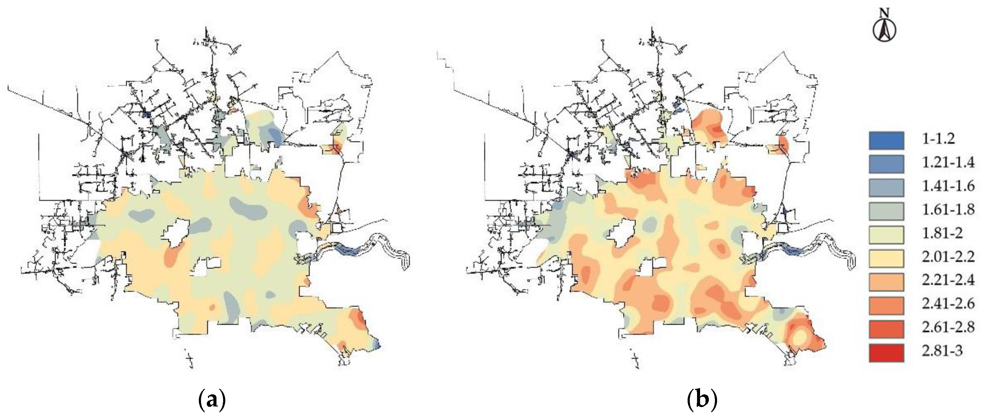
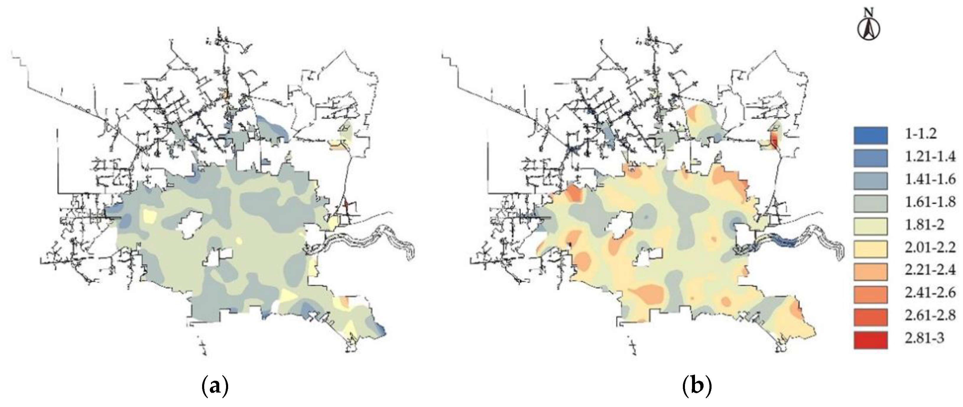
According to Figure 1, the average duration of traffic crashes that do not happen during peak hours is typically above level 2 and in a sizable number of places, but the average duration of crashes that do happen during peak hours is generally below level 2. The map comparison reveals that this portion of the region is primarily a residential area after it reaches level 2.2 or higher.
Long-duration traffic accidents are more likely to happen at night compared to during the day, and drivers who drive during the day are less likely to have slightly serious accidents or accidents that result in significant injury or death. Therefore, the duration of the collision was typically longer when it happened at night. The driving line of sight is worse at night, and drivers are more likely to be exhausted and have more significant accidents on the road than they are during the day [28,29], which is one argument that has been put forth. Since response and processing times are slower at night than during the day, situations may last longer.
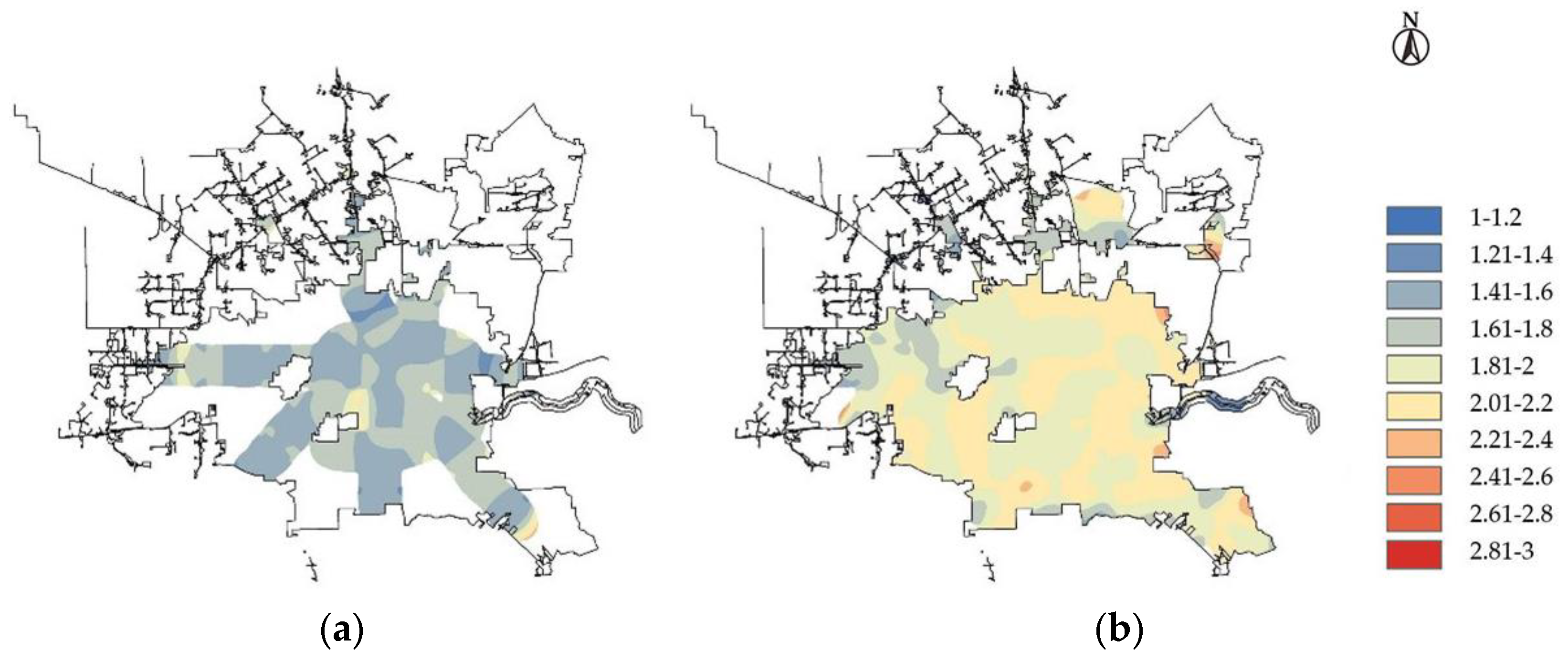
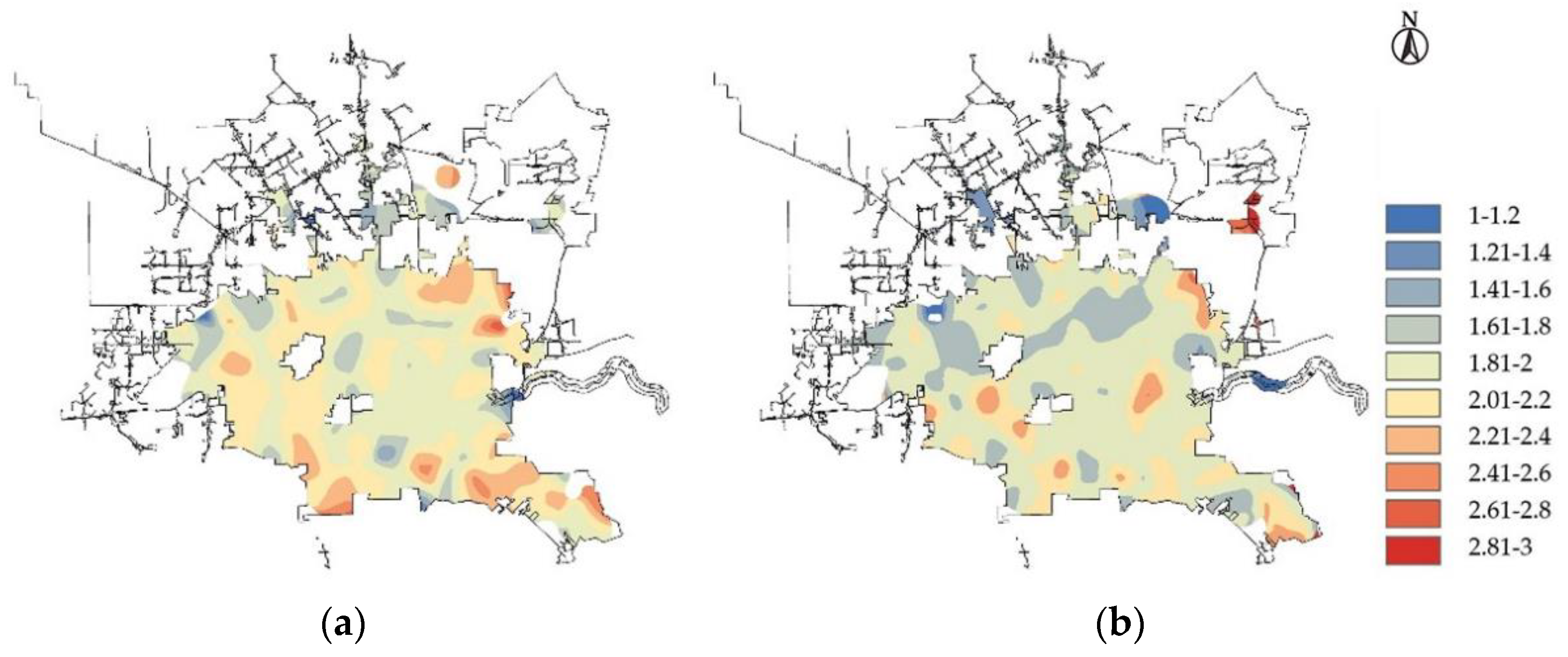
According to Figure 2, the majority of places have an average crash duration during the day that is below Level 2, and only a small number of areas, mostly in the Dyersdale neighborhood and the residential area between Mission Bend and Bellaire, have an average crash duration that is above Level 2. The duration of nighttime traffic accidents was typically greater.
Serious traffic accidents are more likely to happen on non-working days compared to working days. Driving on workdays only increases the likelihood of serious traffic accidents by 0.427 times compared to driving on non-workdays. Weekend traffic accidents often include more significant injuries and have slower reaction times, according to studies [30].
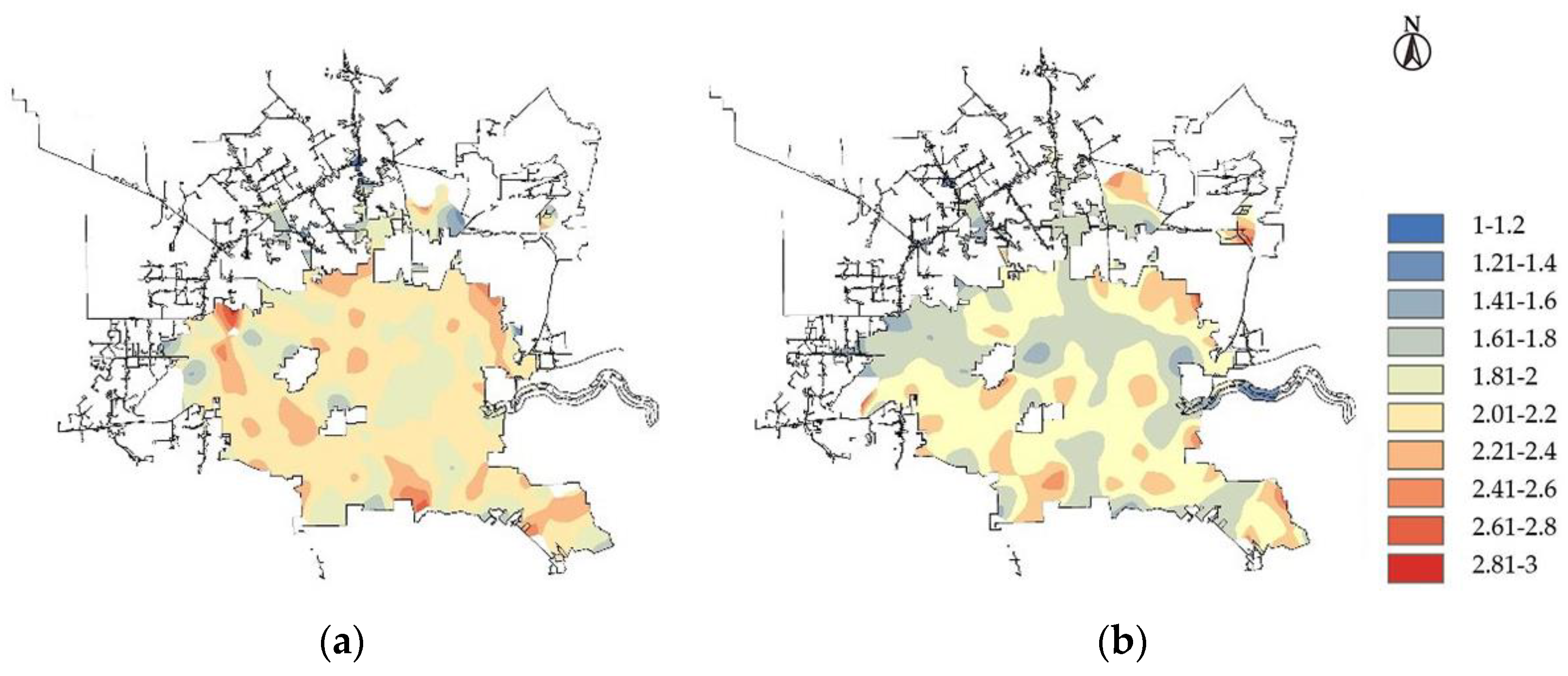
Figure 3 illustrates that while the average length of traffic crashes during working days is typically below level 2.2, during non-working days, the average length of crashes is typically above level 2.4 or even higher. Level 2.6 and above were notably in the region east of Mission Bendy and south of Bellaire.
Regarding the road factors, the location of the accident—such as whether it occurred on a highway, by the side of the road, close to an intersection, where a pedestrian was crossing, where a stop sign was, where a traffic signal was, etc.—had a more significant impact on how long the accident lasted.
The likelihood of slightly serious or serious traffic crashes for drivers on highways is only 0.539 times and 0.288 times that on other routes, respectively. Slightly serious or serious traffic crashes are less likely to occur on highways than on other roads [31]. The duration of a crash was typically shorter when it occurred on a road. One explanation is that there is typically a better level of service on the highway, which allows for quicker response to traffic crashes, resulting in generally shorter crash durations [32].
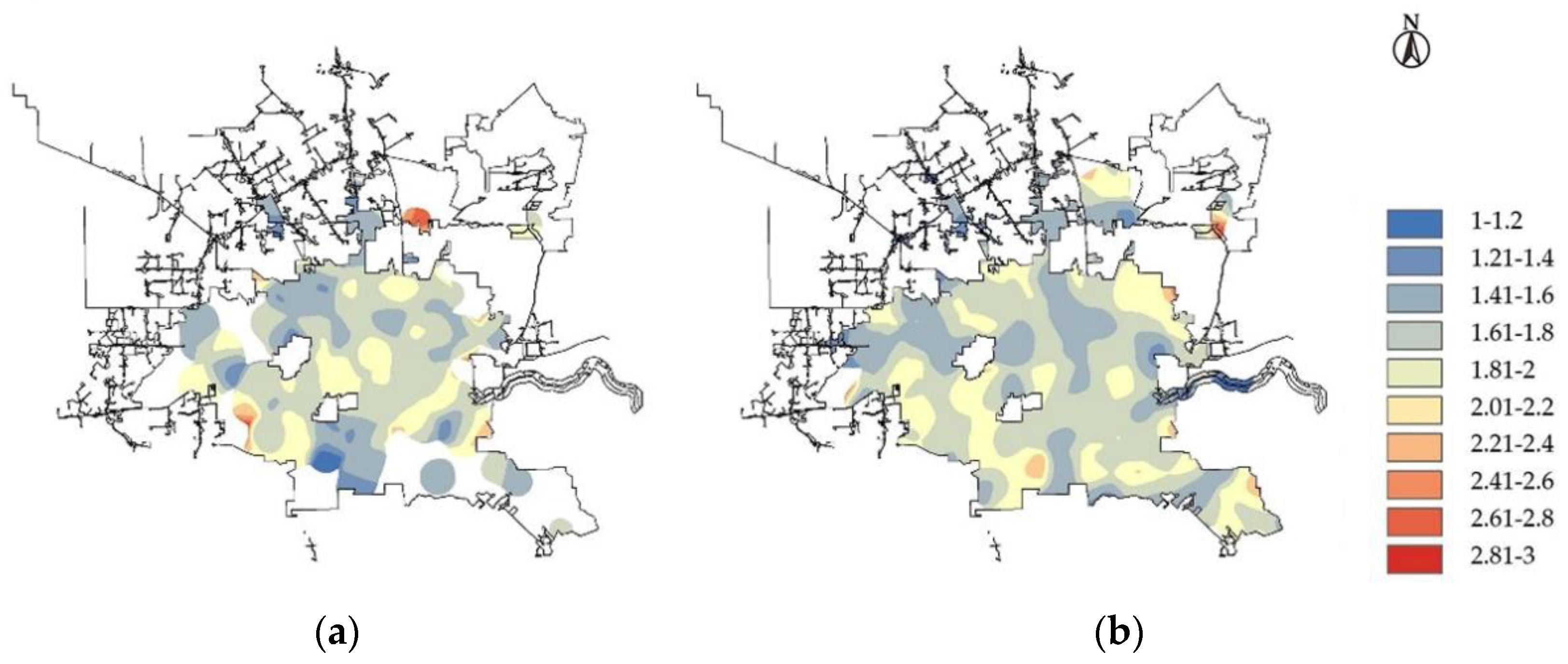
Traffic crashes on other roads have reached level 2 or above in a relatively small portion of the area, as indicated in Figure 4, while the duration of crashes on highways is often below level 1.8, with Levy Park and other locations being the only exceptions, where crashes reach level 2 or above.
The left side of the road is more likely to create serious or serious traffic crashes than the right side of the road, and the likelihood of a motorist driving on the left side of the road causing a slightly serious or serious traffic crash is 1.375 times and 1.644 times that of a driver driving on the right side of the road. One rationale is that vehicles traveling in the opposite direction, on the left side of the road in Europe and the United States, are more likely to be involved in serious traffic accidents and require longer to respond to them.
The duration of accidents that happened on the left side of the road, as shown in Figure 5, reached level 2 or above in the majority of places and level 2.2 or above in many others, such as the vicinity of Sterling High School and Jumping Word. However, the majority of places were below level 2. Right-side traffic crashes also frequently reached level 2 in many locations.
Slightly serious or serious traffic crashes are less likely to happen near intersections compared to other road segments [33,34]. Driving near an intersection increases the likelihood of a serious or slightly serious traffic crash by 0.669 times and 0.357 times, respectively, compared to driving on other road segments. When approaching intersections, drivers are usually more careful and slow down, which lowers the likelihood of catastrophic traffic collisions.
As seen in Figure 6, the duration of traffic crashes close to junctions is often brief, with the majority of locations falling below level 1.4, while certain areas are longer, reaching level 2.4 or above due to the low frequency of such crashes. Taking into account the effects that could result from specific, more severe road accidents, the majority of traffic accidents on the roadways near the non-intersections lasted longer than level 1.8, while certain areas—mostly residential areas—reached level 2 or higher.
Slightly serious or serious traffic crashes are more likely to occur near pedestrian crossings than other road segments. The probability of a driver having a serious or serious traffic crash when driving near a pedestrian crossing is 1.31 times and 1.258 times that of other road sections, respectively. A possible explanation is that most traffic crashes near pedestrian crossings are human–vehicle crashes, which usually require longer processing time because of the casualties involved [35].
The variation in how long a road traffic collision lasts depending on whether or not it happens near a pedestrian crossing is not immediately evident from the image, as seen in Figure 7. Traffic accidents that occurred near pedestrian crossings exhibited longer durations primarily in areas with dense workplaces, while traffic accidents that did not occur near pedestrian crossings exhibited longer durations primarily in residential areas, with the possible exception of a few individual long duration points.
Compared with other road sections, slightly serious or serious traffic crashes are more likely to occur near stop signs. The probability of a driver having a serious or slightly serious traffic crash when driving near a stop sign is 1.393 and 1.234 times that of other road sections. A possible explanation is that parking signs are usually set at intersections without signal control, at the entrances and exits of public buildings on the roadside, etc. [36]. Once a crash occurs in these places, it is usually slightly serious, or it is easy to cause traffic jams, which requires more attention and usually require longer processing time.
According to Figure 8, Houston’s north-central region, specifically the area inside the 610 freeway, has the greatest influence on the length of time that traffic crashes last. In this region, the distribution of average durations for road crashes that do not happen near stop signs is flipped, with residential areas’ average durations near stop signs being longer and heavier inhabited areas’ average durations being shorter.
Compared with other road sections, the probability of slightly serious traffic crashes near traffic lights is higher, which is 1.184 times that of other road sections, and the probability of serious traffic crashes is lower, which is 0.592 times that of other road sections. One possible explanation is that the driver’s speed is lower near the traffic light, and the driver is usually more focused, and it is not easy to cause a traffic crash with serious consequences, but the traffic crash near the intersection can easily cause congestion and takes a certain amount of time.
The average length of traffic crashes that do not occur near traffic lights is generally above level 2, and in some residential areas and other regions has reached level 2.4 or above, as shown in Figure 9. The average length of traffic crashes that do not occur near traffic lights is generally below level 1.8, as shown in the figure.
In terms of environmental factors, body temperature has a significant impact on the duration of traffic crashes. The analysis results show that heavier traffic crashes are more likely to occur when the somatosensory temperature is level 1, and the probability is 1.236 times that when the driver is driving at level 4 temperature. One possible reason is that human hearing, vision, and movement will be affected to a certain extent when the somatosensory temperature is too low, and slightly serious traffic crashes are more likely to occur, requiring longer processing time [37].
The average duration of traffic crashes is shorter overall when the somatosensory temperature is level 4, but it is longer in the locations near the intersection of the West Park Tollway and Sam Houston Tollway and around Hidalgo Park, as illustrated in Figure 10. When the somatosensory temperature reaches level 1, especially in some residential areas, the average duration of traffic accidents is typically longer.

6. Conclusions

Taking 2020 road traffic accidents in Houston as an example, this study preprocessed the data and screened 14 variables. The accident duration was used to reflect the impact of traffic accidents on the overall traffic, and the significant influencing factors of the accident duration were explored by multinomial logit regression analysis. Based on the mathematical analysis results, the spatial characteristics of the traffic accident duration were analyzed by GIS. By combining the analysis of mathematical statistics and spatial distribution characteristics, the significant influencing factors of the duration of road traffic accidents and the spatial distribution characteristics of the duration of road traffic accidents under different perspectives of significant factors are obtained. The analysis of spatial characteristics based on mathematical statistics results can get more scientific analysis results and help to put forward improvement measures according to local conditions. The conclusions of this study are as follows:
(1)
The significant influencing elements of heavy traffic accidents and serious traffic accidents were comparable when using general traffic accidents as the reference item. Heavy traffic accidents and serious traffic accidents were significantly influenced by day or night, highway, accident roadside, intersection, crosswalk, traffic signal, and stop sign; serious traffic accidents were significantly influenced by peak hour and weekday; and heavier traffic accidents were significantly influenced by body temperature. Body temperature has a considerable impact on more severe auto accidents. When attempting to minimize the delay brought on by traffic accidents, several considerations should be taken into consideration.
(2)
Through spatial analysis, it has been discovered that traffic accidents generally last longer in residential areas. At the same time, serious accidents are more likely to happen at night and on non-working days, necessitating attention. In order to ensure traffic safety, residential areas’ nighttime lighting conditions should be enhanced, and nighttime and non-working daytime traffic control should be strengthened to increase the response time of crash handling departments.
(3)
The study found that the crash durations show different trends near different road facilities. In some road sections, it is necessary to focus on traffic safety issues and take optimization measures, such as: near pedestrian crossings and near stop signs. Traffic crashes with a long duration often occur in the above sections, and traffic safety should be ensured by setting traffic signs, speed limits, and speed bumps.
Compared with the simple mathematical statistical analysis or spatial characteristics analysis, the results obtained by the combination of the two analyses are more scientific. The research method of this paper can be used in different cities according to local conditions, which is convenient for decision-makers to propose traffic safety improvement measures, reduce traffic accident losses, and improve the capacity of regional road network. In future research, more accurate analysis results can be obtained by constructing a more comprehensive set of influencing factors or using other statis-tical analysis methods. At the same time, for cities with the same characteristics (such as similar road network structure), the common characteristics of road traffic accident duration can be explored through this research method for future reference.

Author Contributions

Conceptualization, X.S. and H.H.; data curation, H.H. and J.W.; funding acquisition, X.S. and H.L.; formal analysis, K.L. and S.M.; investigation, X.S. and S.M.; methodology, H.H. and J.W.; project administration, X.S. and H.L.; resources, X.S.; writing—original draft preparation, H.H. and J.W.; writing—review and editing, X.S.; supervision, H.L. All authors have read and agreed to the published version of the manuscript.

Funding

This research was funded by the Youth Project of Beijing Social Science Fund (20GLC048).

Institutional Review Board Statement

Not applicable.

Informed Consent Statement

Not applicable.

Data Availability Statement

Not applicable.

Conflicts of Interest

The authors declare no conflict of interest.

References

  1. Zhang, Y. The world health organization released the “2018 Global Road Safety Status Report”. Chin. J. Disaster Med. 2019, 2, 100. [Google Scholar]
  2. Wang, H.M. Present situation of road traffic accident in China and its characteristics. China Saf. Sci. J. 2009, 10, 121–126. [Google Scholar] [CrossRef]
  3. Bardal, K.G.; Jorgensen, F. Valuing the risk and social costs of road traffic accidents—Seasonal variation and the significance of delay costs. Transp. Policy 2017, 57, 10–19. [Google Scholar] [CrossRef]
  4. Zhang, L. Study on the Relationship between Urban Road Traffic Accident Duration Prediction and Accident Influencing Factors. Master’s Thesis, Beijing Jiaotong University, Beijing, China, 2021. [Google Scholar] [CrossRef]
  5. Yang, Y.; He, K.; Wang, Y.P.; Yuan, Z.Z.; Yin, Y.H.; Guo, M.Z. Identification of dynamic traffic crash risk for cross-area freeways based on statistical and machine learning methods. Phys. A Stat. Mech. Its Appl. 2022, 595, 127083. [Google Scholar] [CrossRef]
  6. Yang, Y.; Yuan, Z.; Meng, R. Exploring Traffic Crash Occurrence Mechanism toward Cross-Area Freeways via an Improved Data Mining Approach. J. Transp. Eng. Part A Syst. 2022, 148, 04022052. [Google Scholar] [CrossRef]
  7. Wang, J.Y.; Lu, H.P.; Sun, Z.; Wang, T. A method for identifying influencing factors of severity of vehicle crash based on MNL model. J. Highw. Transp. Res. Dev. 2021, 10, 107–113. [Google Scholar]
  8. Li, G. Highway Traffic Accident Severity Prediction Based on Ordered Logit and Multinomial Logit Model. Master’s Thesis, Chang’an University, Shaanxi, China, 2018. [Google Scholar]
  9. Celik, A.K.; Oktay, E. A multinomial logit analysis of risk factors influencing road traffic injury severities in the Erzurum and Kars Provinces of Turkey. Accid. Anal. Prev. 2014, 11, 66–77. [Google Scholar] [CrossRef]
  10. Wu, Q.; Zhang, G.H.; Zhu, X.Y. Analysis of driver injury severity in single-vehicle crashes on rural and urban roadways. Accid. Anal. Prev. 2016, 94, 35–45. [Google Scholar] [CrossRef]
  11. Topuz, K.; Delen, D. A probabilistic bayesian inference model to investigate injury severity in automobile crashes. Decis. Support Syst. 2021, 150, 113557. [Google Scholar] [CrossRef]
  12. Yang, Y.; Wang, K.; Yuan, Z.; Liu, D. Predicting freeway traffic crash severity using XGBoost-Bayesian network model with consideration of features interaction. J. Adv. Transp. 2022, 2022, 4257865. [Google Scholar] [CrossRef]
  13. Jeong, H.; Jang, Y.; Bowman, P.J.; Masoud, N. Classification of motor vehicle crash injury severity: A hybrid approach for imbalanced data. Accid. Anal. Prev. 2018, 12, 250–261. [Google Scholar] [CrossRef] [PubMed]
  14. Erdogan, S.; Yilmaz, I.; Baybura, T.; Gullu, M. Geographical information systems aided traffic accident analysis system case study: City of Afyonkarahisar. Accid. Anal. Prev. 2008, 1, 174–181. [Google Scholar] [CrossRef] [PubMed]
  15. Lu, H.P.; Luo, S.X.; Li, R.M. GIS-based spatial patterns analysis of urban road traffic crashes in shenzhen. China J. Highw. Transp. 2019, 8, 156–164. [Google Scholar] [CrossRef]
  16. Singh, N.; Katiyar, S.K. Application of geographical information system (GIS) in reducing accident blackspots and in planning of a safer urban road network: A review. Ecol. Inform. 2021, 66, 101436. [Google Scholar] [CrossRef]
  17. Rodrigues, D.S.; Ribeiro, P.J.; Nogueira, I.C. Safety classification using GIS in decision-making process to define priority road interventions. J. Transp. Geogr. 2015, 43, 101–110. [Google Scholar] [CrossRef]
  18. Yang, S.; Lu, S.J.; Wu, Y.J. GIS-based economic cost estimation of traffic accidents in St. Louis, Missouri. Procedia Soc. Behav. Sci. 2013, 96, 2907–2915. [Google Scholar] [CrossRef] [Green Version]
  19. Shafabakhsh, G.A.; Famili, A.; Bahadori, M.S. GIS-based spatial analysis of urban traffic accidents: Case study in Mashhad, Iran. J. Traffic Transp. Eng. 2017, 4, 290–299. [Google Scholar] [CrossRef]
  20. Al-Aamri, A.K.; Hornby, G.; Zhang, L.C.; Al-Maniri, A.A.; Padmadas, S.S. Mapping road traffic crash hotspots using GIS-based methods: A case study of Muscat Governorate in the Sultanate of Oman. Spat. Stat. 2021, 42, 100458. [Google Scholar] [CrossRef]
  21. Sun, F.H.; Ban, X.X.; Qi, L.L. The “body sense” temperature calculation method. Meteorol. Sci. Technol. 2002, 5, 282–283+303. [Google Scholar] [CrossRef]
  22. Jin, A. On methodology of parameter estimation in logit model. J. Transp. Syst. Eng. 2004, 1, 71–75. [Google Scholar] [CrossRef]
  23. Zou, T.H.; Xie, J.; Liu, J.F.; Chen, P. Analysis on the spatial distribution of junior middle school education resources based on GIS in Neijiang. Geomat. Spat. Inf. Technol. 2022, 6, 8–13. [Google Scholar]
  24. Chen, J.L. Research on Identifing Hotspots in the Urban Road Networks Based on the Network Kernel Density Estimation Method. Master’s Thesis, Southeast University, Nanjin, China, 2015. [Google Scholar]
  25. Chen, Y.; Xiangnan, L.I.; Sun, Z. Identification method of factors affecting traffic accident based on Logistics. Technol. Econ. Areas Commun. 2018, 5, 1–5. [Google Scholar] [CrossRef]
  26. Ding, C.; Ma, X.L.; Wang, Y.H. Exploring the influential factors in incident clearance time: Disentangling causation from self-selection bias. Accid. Anal. Prev. 2015, 85, 58–65. [Google Scholar] [CrossRef] [PubMed]
  27. Chen, C.K.; Zhang, J. Exploring background risk factors for fatigue crashes involving truck drivers on regional roadway networks: A case control study in Jiangxi and Shaanxi, China. Springer Plus 2016, 5, 582. [Google Scholar] [CrossRef] [Green Version]
  28. Zhang, P.; Wang, C.; Chen, F.; Cui, S.; Cheng, J.; Bo, W. A random-parameter negative binomial model for assessing freeway crash frequency by injury severity: Daytime versus nighttime. Sustainability 2022, 14, 9061. [Google Scholar] [CrossRef]
  29. Helai, H.; Chor, C.H.; Haque, M.M. Severity of driver injury and vehicle damage in traffic crashes at intersections: A Bayesian hierarchical analysis. Accid. Anal. Prev. 2008, 40, 45–54. [Google Scholar] [CrossRef]
  30. Nam, D.; Mannering, F. An exploratory hazard-based analysis of highway incident duration. Transp. Res. Part A Policy Pract. 2000, 34, 85–102. [Google Scholar] [CrossRef]
  31. Yang, Y.; Tian, N.; Wang, Y.; Yuan, Z. A Parallel FP-Growth Mining Algorithm with Load Balancing Constraints for Traffic Crash Data. Int. J. Comput. Commun. Control 2022, 17, 4806. [Google Scholar] [CrossRef]
  32. Ma, A. Research on the Duration and Influence Scope of Expressway Traffic Accidents. Master’s Thesis, Chang’an University, Shaanxi, China, 2013. [Google Scholar]
  33. Jin, W.; Chowdhury, M.; Salek, M.S.; Khan, S.M.; Gerard, P. Investigating hierarchical effects of adaptive signal control system on crash severity using random-parameter ordered regression models incorporating observed heterogeneity. Accid. Anal. Prev. 2021, 150, 105895. [Google Scholar] [CrossRef]
  34. Shi, X. Research on Speed Control and Visual Search Behavior of Drivers at Urban Signalized Intersections. Master’s Thesis, Chang’an University, Shaanxi, China, 2011. [Google Scholar]
  35. Gao, L. Conflict Analysis and Delay Modeling between Pedestrians and Motor Vehicles at Pedestrian crossing in Urban Road Environment. Ph.D. Thesis, Beijing Jiaotong University, Beijing, China, 2010. [Google Scholar]
  36. Shao, Z.Q. Analysis and optimization of stop and yield signs at intersections and setting of yield lines. Shandong Transp. Sci. Technol. 2021, 5, 128–131. [Google Scholar] [CrossRef]
  37. Wang, D.; Li, L.; Wu, Q.; Luan, J. Analysis of the influence of adverse weather conditions on expressway traffic crashes. In Proceedings of the 32nd Annual Meeting of China Meteorological Society, Tianjin, China, 14 October 2015; p. 501. [Google Scholar]
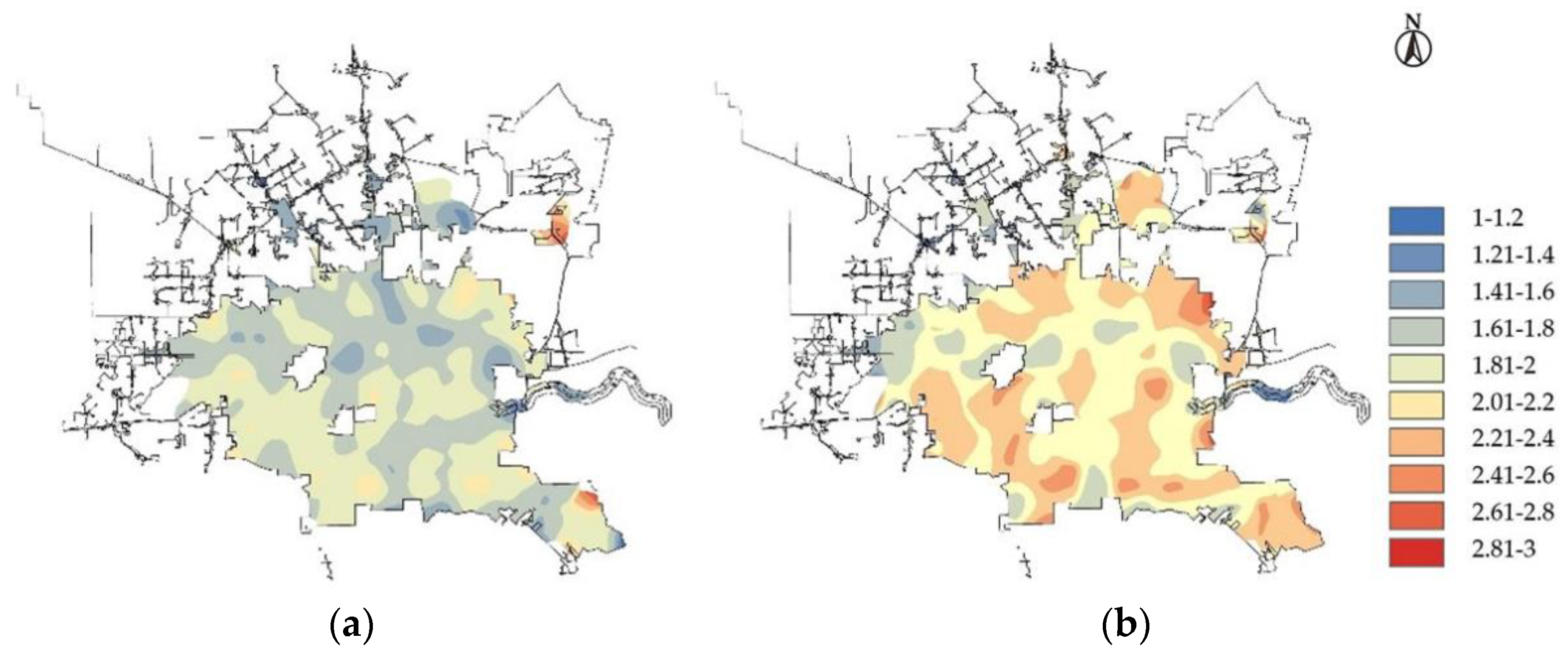
Figure 1. Comparison of the distribution of average crash times during peak and off–peak hours. (a) During peak hours, (b) during off–peak hours.
Sustainability 14 14982 g001
Figure 2. Comparison of the average accident duration distribution from the time perspective. (a) During the daytime, (b) at night.
Sustainability 14 14982 g002
Figure 3. Comparison of the average duration distribution of traffic accidents during working days and holidays. (a) During working days, (b) during holidays.
Sustainability 14 14982 g003
Figure 4. Comparison of the average accident duration distribution from the highway perspective. (a) On the highway, (b) on other roads.
Sustainability 14 14982 g004
Figure 5. Comparison of the average duration distribution of traffic accidents in roadside perspective. (a) Occurred on the left side of the road, (b) occurred on the right side of the road.
Sustainability 14 14982 g005
Figure 6. Comparison of the average duration distribution of traffic accidents from intersection perspective. (a) Near intersections, (b) other road sections.
Sustainability 14 14982 g006
Figure 7. Comparison of average accident duration distribution in crosswalk perspective. (a) Near crosswalks, (b) other roadways.
Sustainability 14 14982 g007
Figure 8. Comparison of average accident duration distribution from the parking sign perspective. (a) Near stop signs, (b) other road sections.
Sustainability 14 14982 g008
Figure 9. Comparison of average accident duration distribution under traffic light perspective. (a) Near traffic lights, (b) other roadways.
Sustainability 14 14982 g009
Figure 10. Comparison of the mean duration distribution of accidents in the perspective of body temperature. (a) Somatosensory temperature is level 1, (b) somatosensory temperature is level 4.
Sustainability 14 14982 g010
Table 1. Definition of different values of factors affecting the duration of traffic crashes.
Variable CategoryVariable NameVariable Assignment and Proportion
Dependent VariableDuration1 (36%) = general traffic crash (duration ≤ 60 min),
2 (41.9%) = serious traffic crash (60 min < duration ≤ 120 min),
3 (22.1%) = serious traffic crash (duration > 120 min)
TimePeak hours1 (40.8%) = occurred during peak hours, 0 (59.2%) = did not occur during peak hours
Season1 (17.3%) = spring, 2 (16.9%) = summer, 3 (33.6%) = autumn, 4 (32.3%) = winter
Weekday0 (86.8%) = occured on a weekday, 1 (13.2%) = did not occur on a weekday
Day or night1 (65.3%) = daytime, 0 (34.7%) = nighttime
Roadway Happens on the highway1 (22.3%) = Yes, 0 (77.7%) = No
Roadside crash1 (24.2%) = Left, 0 (75.8%) = Right
Near the intersection1 (3.6%) = Yes, 0 (96.3%) = No
Near the crosswalk1 (9.6%) = Yes, 1 (90.4%) = No
Near a stop sign1 (6.1%) = Yes, 0 (93.9%) = No
Near traffic lights1 (28.1%) = Yes, 0 (71.9%) = No
The EnvironmentSensible temperature1 (15%) = (sensible temperature < 10 °C), 2 (26%) = (10 °C ≤ sensible temperature ≤ 20 °C), 3 (40.5%) = (20 °C ≤ sensible temperature < 30 °C), 4 (18.6%) = (sensible temperature ≥ 30 °C)
Visibility1 (88.8%) = high visibility, 2 (3.8%) = average visibility, 3 (7.4%) = poor visibility
Snowy and Rainy0 (8.7%) = No, 1 (91.3%) = Yes
Table 2. Model fitting information.
ModelModel Fit ConditionsLikelihood Ratio Test
−2 log−LikelihoodChi−SquareDegrees of FreedomSignificant
Only intercept15,855.336
In the end11,488.4354366.901500
Table 3. Parameter estimation results of significant variables.
CategoryEffective FactorsSlightly Serious Traffic CrashesSerious Traffic Crash
BWaldpORBWaldpOR
Peak hour----0.461 96.085 0 0.631
TimeDay or night0.299 54.744 0 0.742 0.771 252.942 0 0.463
Weekdays----0.85 186.005 0 0.427
The roadHighway0.618187.72200.5391.246 393.552 0 0.288
Side of the road0.319 53.715 0 1.375 0.497 90.189 0 1.644
Near the intersection0.402 20.417 0 0.669 1.03 46.697 0 0.357
Near a crosswalk0.27 17.903 0 1.31 0.23 7.084 0.008 1.258
Near stop signs0.331 17.394 0 1.393 0.21 5.059 0.024 1.234
Near traffic signals0.169 15.722 0 1.184 0.524 81.535 0 0.592
The
environment
Somatosensory temperature level 10.2126.8630.0091.236----
Publisher’s Note: MDPI stays neutral with regard to jurisdictional claims in published maps and institutional affiliations.