
The “Perfect Village” Model as a Result of Research on Transformation of Plant Cover—Case Study of the Puchaczów Commune


Abstract
1. Introduction
2. Literature Review
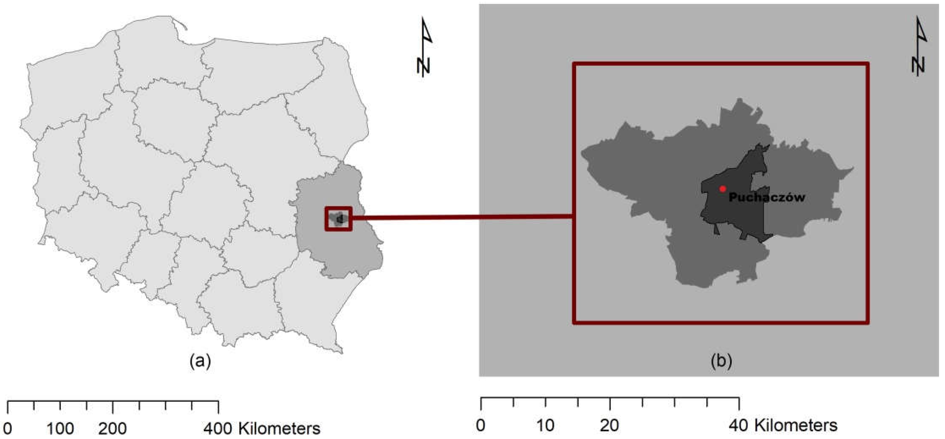
3. Study Area
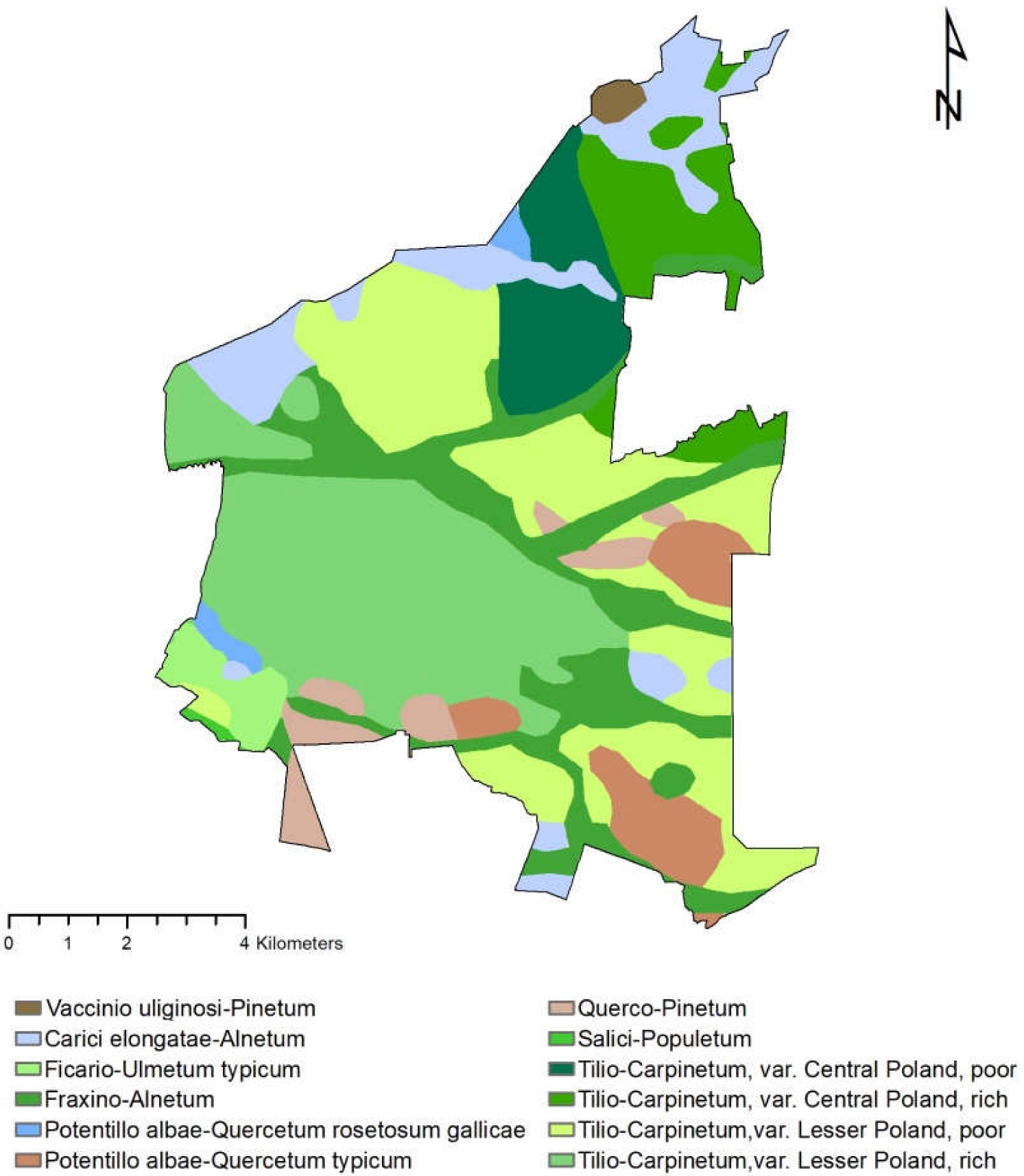
3.1. Characteristics of the Potential and Actual Vegetation of the Puchaczów Commune
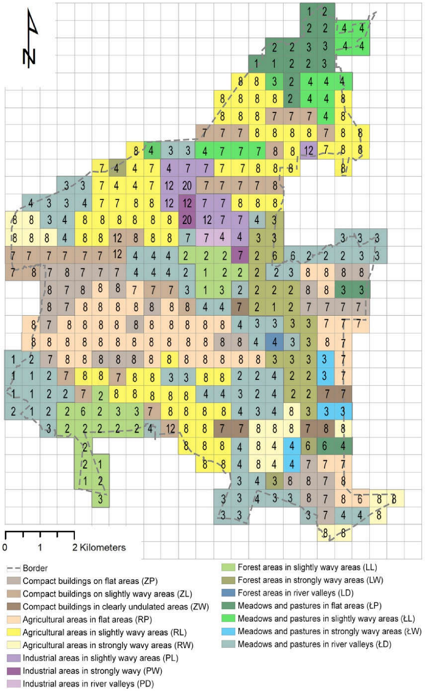
3.2. Valorization of the Landscape of the Puchaczów Commune
4. Materials and Methods
4.1. Data Sources
4.2. Guidelines for the Formation of a “Perfect Village”
4.3. Forecasting Changes in the Landscape and Comparing Them with the Model of the “Ideal Village”
5. Results
5.1. The “Perfect Village” Model

| 1. Plants Recommended for the Reclamation of Mining Areas | |
|---|---|
| Erosion control plants | Phytomelioration species |
| Robinia pseudoacacia | Alnus glutinosa |
| Caragana arboescens | Alnus incana |
| Salix acutifolia | Alnus viridis |
| Salix caprea | Salix caprea |
| Salix viminalis | |
| Hippophae rhamnoides | |
| Biocenotic plants | Final plantings |
| Sorbus aucuparia | Pinus sylvestris |
| Prunus padus | Betula pendula |
| Corylus avellana | Acer platanoides |
| Sambucus nigra | Larix decidua |
| Sambucus racemosa | Ulmus scabra |
| Euonymus europae | Tilia cordata |
| Crataegus oxycantha | Populus sp. |
| Fagus sylvatica | |
| Grasses | |
| Festuca rubra Festuca pratensis Festuca ovina | Dactylis glomerata Arrhenatherum elatius Poa pratensis |
| 2. Planting Isolating Industrial Zones | |
| Basic plantings | Auxiliary plantings |
| Acer platanoides | Sambucus nigra |
| Tilia cordata | Pinus nigra |
| Carpinus betulus | Salix caprea |
| Crataegus monogyna | Euonymus europaeus |
| Picea abies | Physocarpus opulifolius |
| Sorbus aucuparia | Alnus incana |
| Betula pendula | Euonymus verrucosus |
| Salix purpurea | |
| 3. Plants Recommended for Field Trees | |
| Basic plantings | Auxiliary plantings |
| Acer platanoides | Prunus avium |
| Acer pseudoplatanus | Pinus sylvestris |
| Tilia cordata | Quercus petraea |
| Tilia platyphyllos | Quercus robur |
| Alnus glutinosa | Acer campestre |
| Betula pendula | Sambucus racemosa |
| Betula pubescens | Fagus sylvatica |
| Larix decidua | Prunetalia spinosae |
| Salix caprea | |
| Sorbus aucuparia | |
| Prunus spinosa | |
| Rhamnus frangula | |
| Crataegus sp. | |
| Ribes sp. | |
| Barren habitats | Moist and fertile habitats |
| Betula pendula | Prunus padus |
| Picea pungens | Euonymus europaeus |
| Pyrus communis | Sorbus aucuparia |
| Prunus spinosa | Corylus avellana |
| Malus sylvestris | Sambucus nigra |
| Salix × fragilis | Alnus glutinosa |
| Viburnum opulus | Salix alba |
| Ulmus minor | Cornus alba |
| 4. Species for Planting on the Banks of Rivers | |
| Basic plantings | Auxiliary plantings |
| Betula pubescens | Prunus padus |
| Fraxinus excelsior | Alnus incana |
| Salix viminalis | Sambucus nigra |
| Alnus glutinosa | Salix pentandra |
| Salix purpurea | |
| Salix alba | |
| Perennials and grasses | |
| Matteuccia struthiopteris | Trollius europaeus |
| Lithrum salicaria | Aruncus dioicus |
| Filipendula ulmaria | Carex sp. |
| Cirsium rivulare | Polemonium caeruleum |
| Lichnis flos-cuculi | Thalictrum angustifolium |
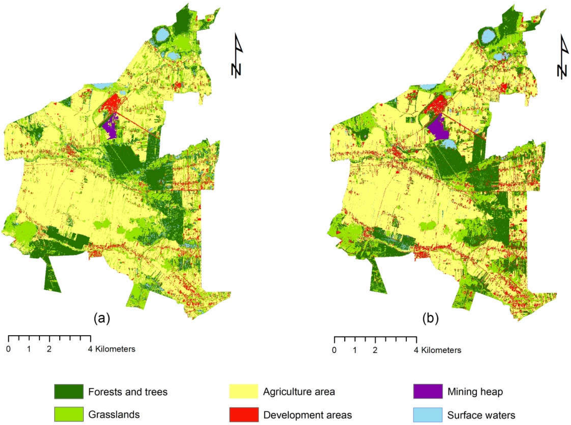
5.2. Land Cover Changes
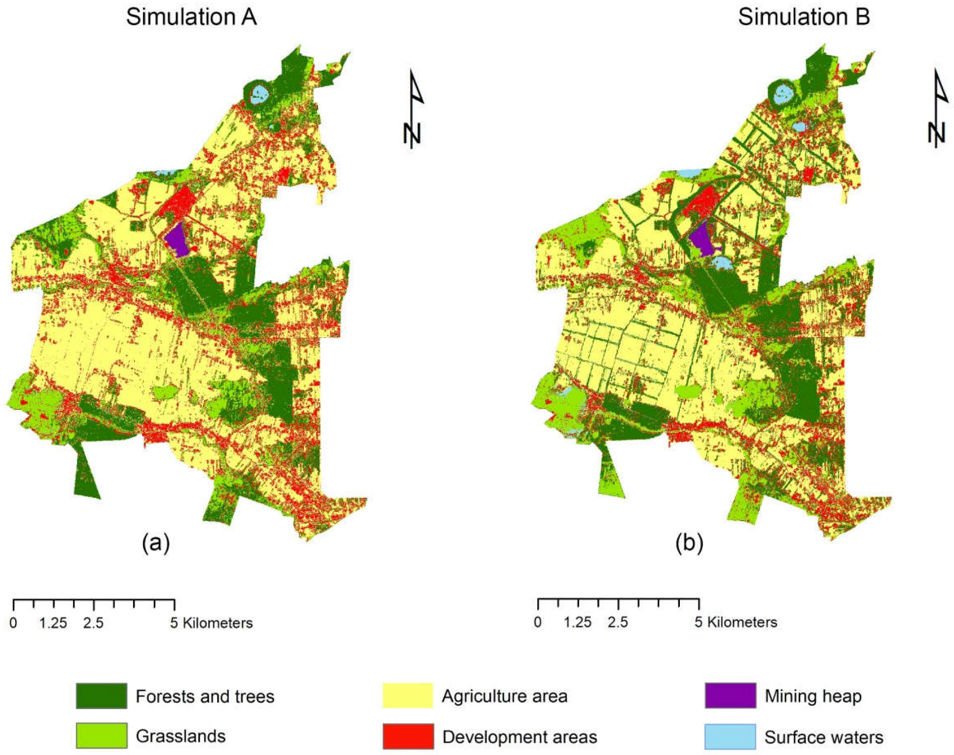
5.3. Forecasts of Land Cover in the Puchaczów Commune for the Year 2050
6. Discussion
7. Conclusions
- The basis for identifying appropriate guidelines for shaping the natural systems of rural areas are landscape studies, including the study of vegetation.
- Shaping the “perfect village” should begin with the identification of the most problematic areas (to the greatest extent degraded by human activity), because they require special measures to reduce their negative impact on the environment. Such zones should be isolated by plantings in the ring system, creating a specific gradient between the conflict areas and the neighboring areas. In the case of industrial development, an important issue is to plan the reclamation process, which is also related to the appropriate selection of plants.
- In agricultural areas that require reconstruction of spatial systems, it is necessary to rebuild or create new field plantings. They should have a stripe form, creating a network of trees.
- The activities of reconstruction and strengthening of natural systems planned as part of the “perfect village” should aim at rebuilding the continuity of ecological structures. This can be achieved by creating new plantings, for example, along water courses, establishing flower meadows and afforestation.
- The process of securing natural systems is not only related to environmental protection, but also to monitor and control the changes that take place in it.
Supplementary Materials
Author Contributions
Funding
Informed Consent Statement
Data Availability Statement
Conflicts of Interest
References
- Paszkowski, Z. Miasto Idealne w Perspektywie Europejskiej i Jego Związki z Urbanistyką Współczesną; Universitas: Kraków, Poland, 2012; pp. 17–19. [Google Scholar]
- Szpakowska, E. Atlas miast idealnych. XVI—XVIII wiek. Przestrz. I Forma 2012, 17, 165–188. [Google Scholar]
- Zelenika, I.; Pearce, J. Barriers to Appropriate Technology Growth in Sustainable Development. Eur. J. Sustain. Dev. 2011, 4, 12–22. [Google Scholar] [CrossRef]
- Wanner, A.; Pröbstl-Haider, U. Barriers to Stakeholder Involvement in Sustainable Rural Tourism Development—Experiences from Southeast Europe. Sustainability 2019, 11, 3372. [Google Scholar] [CrossRef]
- Panorama, M. Barriers on Rural Development in Musi Banyuasin (MUBA) District, South Sumatera, Indonesia. J. Econ. Manag. Perspect. 2018, 12, 542–551. [Google Scholar]
- Burja, C.; Burja, V. Sustainable development of rural areas: A challenge for Romania. Environ. Eng. Manag. J. 2014, 13, 1861–1871. [Google Scholar] [CrossRef]
- Dąbrowski, A.; Górska, D.; Świstak, P.; Gunia, A.; Sokalska, K. Bariery zrównoważonego rozwoju obszarów wiejskich w Polsce. Syst. Wspomagania W Inżynierii Prod. 2019, 8, 70–82. [Google Scholar]
- Mickiewicz, B.; Jurczak, R. Barriers to the Development of Green Economy in Rural Areas of Selected Districts of the Greater Poland Province. Eur. Res. Stud. J. 2021, 24, 314–324. [Google Scholar] [CrossRef]
- Skubiak, B. Rola programu Leader w rozwoju obszarów wiejskich w Polsce. In Zrównoważony Rozwój Obszarów Wiejskich, Wybrane Aspekty Społeczne; Kryk, B., Ed.; Uniwersytet Szczeciński, Katedra Polityki Społeczno-Gospodarczej i Europejskich Studiów Regionalnych: Szczecin, Poland, 2010; pp. 165–184. [Google Scholar]
- Dumitru, E.A.; Ursu, A.; Tudor, V.C.; Micu, M.M. Sustainable Development of the Rural Areas from Romania: Development of a Digital Tool to Generate Adapted Solutions at Local Level. Sustainability 2021, 13, 11921. [Google Scholar] [CrossRef]
- Przygodzka, R. Zrównoważony rozwój obszarów wiejskich. In Od Koncepcji Ekorozwoju do Ekonomii Zrównoważonego Rozwoju; Kiełczewski, D., Ed.; Wydawnictwo Wyższej Szkoły Ekonomicznej w Białymstoku: Białystok, Poland, 2009; p. 260. [Google Scholar]
- Qi, L.; Liu, R.; Cui, Y.; Zhou, M.; Bonenberg, W.; Song, Z. Study of the Landscape Pattern of Shuiyu Village in Beijing, China: A Comprehensive Analysis of Adaptation to Local Microclimate. Sustainability 2022, 14, 375. [Google Scholar] [CrossRef]
- Viccaro, M.; Caniani, D. Forest, Agriculture, and Environmental Protection as Path to Sustainable Development. Nat. Resour. Res. 2019, 28, 1–4. [Google Scholar] [CrossRef]
- Koreleski, K. Ochrona i kształtowanie terenów rolniczych w systemie kreowania krajobrazu wiejskiego. Infrastrukt. I Ekol. Teren. Wiej. 2009, 4, 5–20. [Google Scholar]
- Niedźwiecka-Filipiak, I.; Gubański, J.; Bocheńska-Skałecka, A.; Kuriata, Z. Rola wyróżników krajobrazu wiejskiego w procesie rewitalizacji wsi. Stud. Obsz. Wiej. 2018, 49, 93–108. [Google Scholar] [CrossRef]
- Niedźwiecka-Filipiak, I.; Kuriata, Z. Ochrona i kształtowanie krajobrazu wsi w pracach Instytutu Architektury Krajobrazu Uniwersytetu Przyrodniczego we Wrocławiu. Archit. Kraj. 2012, 2, 90–98. [Google Scholar]
- Baster, P.; Litwin, U. Polish Rural Designing System Used for the Implementation of the Ideas of Green Deal and Sustainability—Comparison of Landscape and Agricultural Areas Planning, on the Example of Strzelce Wielkie and Kamionka Wielka. Sustainability 2021, 13, 886. [Google Scholar] [CrossRef]
- Brundtland, G. Report of the World Commission on Environment and Development. In Our Common Future; United Nations General Assembly Document A/42/427; Oxford University Press: Oxford, UK, 1987. [Google Scholar]
- Gutowski, B. Przestrzeń Marzycieli Miasto Jako Projekt Utopijny; Oficyna Wydawnicza Feniks: Warszawa, Poland, 2006; pp. 52–54, 89–121. [Google Scholar]
- Rainer Zenz on de.wikipedia—vgl. dazu eine farbige Abb. in: dtv-Atlas zur Baukunst, Bd.2, 4.Auflage, 1985, s. 432, Public Domain. Available online: https://commons.wikimedia.org/w/index.php?curid=1020913 (accessed on 10 June 2022).
- Patnaik, S.; Sen, S.; Mahmoud, M.S. Smart Village Technology. Concepts and Development; Springer: Cham, Switzerland, 2020; pp. 7–9. [Google Scholar]
- Adamowicz, M.; Zwolińska-Ligaj, M. The “Smart Village” as a Way to Achieve Sustainable Development in Rural Areas of Poland. Sustainability 2020, 12, 6503. [Google Scholar] [CrossRef]
- Visvizi, A.; Lytras, M.D. It’s Not a Fad: Smart Cities and Smart Villages Research in European and Global Contexts. Sustainability 2018, 10, 2727. [Google Scholar] [CrossRef]
- The European Network for Rural Development (ENRD)-European Commission. Available online: https://enrd.ec.europa.eu/smart-and-competitive-rural-areas/smart-villages/smart-villages-portal_en (accessed on 14 June 2022).
- The European Network for Rural Development. Smart Villages: Revitalising rural services. EU Rural. Rev. 2018, 26, 10–11. Available online: https://enrd.ec.europa.eu/publications/eu-rural-review-26-smart-villages-revitalising-rural-services_en (accessed on 4 May 2022).
- Kusio, T.; Rosiek, J.; Conto, F. Urban–Rural Partnership Perspectives in the Conceptualization of Innovative Activities in Rural Development: On Example of Three-Case Study Analysis. Sustainability 2022, 14, 7309. [Google Scholar] [CrossRef]
- Zhang, X.; Zhang, Z. How Do Smart Villages Become a Way to Achieve Sustainable Development in Rural Areas? Smart Village Planning and Practices in China. Sustainability 2020, 12, 10510. [Google Scholar] [CrossRef]
- Stojanova, S.; Lentini, G.; Niederer, P.; Egger, T.; Cvar, N.; Kos, A.; Stojmenova Duh, E. Smart Villages Policies: Past, Present and Future. Sustainability 2021, 13, 1663. [Google Scholar] [CrossRef]
- A Framework for Information and Communications Technology Policy Reviews. Available online: https://unctad.org/webflyer/framework-information-and-communications-technology-policy-reviews (accessed on 14 June 2022).
- Zavratnik, V.; Kos, A.; Stojmenova Duh, E. Smart Villages: Comprehensive Review of Initiatives and Practices. Sustainability 2018, 10, 2559. [Google Scholar] [CrossRef]
- Ramesh, R.; SivaRam, P. The idea of a model village: Towards developing a framework to the study of model villages. J. Rural. Dev. 2019, 38, 525–540. [Google Scholar] [CrossRef]
- Goswamy, P.; Adhikari, B. Concept of model villages and agriculture in its core. Food Sci. Rep. 2021, 2, 49–51. [Google Scholar]
- Ministry of Tribal Affairs. Available online: https://tribal.nic.in/Model-village.aspx (accessed on 14 June 2022).
- Ekins, P.; Zenghelis, D. The costs and benefits of environmental sustainability. Sustain. Sci. 2021, 16, 949–965. [Google Scholar] [CrossRef]
- Agovino, M.; Casaccia, M.; Ciommi, M.; Ferrara, M.; Marchesano, K. Agriculture, climate change and sustainability: The case of EU-28. Ecol. Indic. 2019, 105, 525–543. [Google Scholar] [CrossRef]
- Djufry, F.; Wulandari, S. Climate-Smart Agriculture Implementation Facing Climate Variability and Uncertainty in the Coffee Farming System. In Proceedings of the 2nd International Conference on Sustainable Agriculture for Rural Development 2020, Purwokerto, Indonesia, 20 October 2020. [Google Scholar]
- Shahzad, M.F.; Abdulai, A.; Issahaku, G. Adaptation Implications of Climate-Smart Agriculture in Rural Pakistan. Sustainability 2021, 13, 11702. [Google Scholar] [CrossRef]
- Sullivan, A.; Mumba, A.; Hachigonta, S.; Connolly, M.; Sibanda, L.M. Climate Smart Agriculture: More Than Technologies Are Needed to Move Smallholder Farmers Toward Resilient and Sustainable Livelihoods. Food Agric. Nat. Resour. Policy Netw. 2012, 13, 1–4. [Google Scholar]
- Onyeneke, R.U.; Igberi, C.O.; Uwadoka, C.O.; Aligbe, J.O. Status of climate-smart agriculture in southeast Nigeria. GeoJournal 2018, 83, 333–346. [Google Scholar] [CrossRef]
- Stachowicz, S. Zagadnienia wielkości produkcji i jakości węgla w planach rozwojowych Lubelskiego Węgla Bogdanka S.A. Polityka Energetyczna 2005, 5, 623–635. [Google Scholar]
- Mącik, E.; Świerczyńska, A.; Gajos, J.; Laskowski, T.; Pomorski, E.; Żaliński, J.; Czopek, J.; Wiącek, W.; Filas, P.; Butryński, P. Studium uwarunkowań i kierunków zagospodarowania przestrzennego gminy Puchaczów. Załącznik Nr 1 do Uchwały Nr XXXIII/226/21 Rady Gminy Puchaczów z dnia 7 maja 2021 r., EM Biuro Projektów Urbanistyki i Architektury, Lublin, Poland 2021. Available online: https://www.puchaczow.pl/asp/studium-uwarunkowan-i-kierunkow-zagospodarowania-przestrzennego-gminy-puchaczow,8,artykul,28,2908 (accessed on 1 May 2022).
- Sprawozdanie Zarządu z działalności LW Bogdanka S.A. oraz Grupy Kapitałowej LW Bogdanka za 2021r. Available online: https://ri.lw.com.pl/szczegoly-raportu-PER?irr_id=2422 (accessed on 1 July 2022).
- Barwicka, S. Rural landscape analyses as a spatial planning tool on the example of the Puchaczów Commune. Ann. Wars. Univ. Life Sci.—SGGW. Hortic. Landsc. Archit. 2021, 42, 103–116. [Google Scholar] [CrossRef]
- Matuszkiewicz, J.M. Potential Natural Vegetation of Poland; IGiPZ PAN: Warszawa, Poland, 2008. [Google Scholar]
- Szefler, S. The method of determining research units for the needs of valorisation of rural landscape at the level of plant cover on the example of the Puchaczów commune. Acta Sci. Pol. Adm. Locorum 2021, 20, 35–46. [Google Scholar] [CrossRef]
- Plit, J. Antropogeniczne i Naturalne Przeobrażenia Krajobrazów Roślinnych MAZOWSZA (od Schyłku XVIII w. do 1990 r.); Continuo: Wrocław, Poland, 1996; p. 46. [Google Scholar]
- Available online: https://pro.arcgis.com/es/pro-app/2.7/get-started/get-started.htm (accessed on 2 April 2022).
- Available online: https://qgis.org/pl/site/forusers/download.html (accessed on 2 April 2022).
- Kucharski, L. Szata roślinna terenu górniczego złoża Koźmin—jej zmiany i możliwości ochrony. Pr. I Stud. Geogr. 2010, 44, 169–192. [Google Scholar]
- Available online: https://plugins.qgis.org/plugins/molusce/ (accessed on 2 April 2022).
- Kamaraj, M.; Rangarajan, S. Predicting the Future Land Use and Land Cover Changes for Bhavani Basin, Tamil Nadu, India Using QGIS MOLUSCE Plugin. Environ. Sci. Pollut. Res. 2021. [Google Scholar] [CrossRef] [PubMed]
- Rizwan, M.; Zhang, W.; Abbas, Z.; Guo, F.; Gwiazdzinski, L. Spatiotemporal Change Analysis and Prediction of Future Land Use and Land Cover Changes Using QGIS MOLUSCE Plugin and Remote Sensing Big Data: A Case Study of Linyi, China. Land 2022, 11, 419. [Google Scholar] [CrossRef]
- The Act of April 27, 2001, Environmental Protection Law. J. Laws 2001, 62, 627.
- Act of February 3, 1995 on the protection of agricultural and forest land. J. Laws 1995, 16, 78.
- The Act of 10 July 2008 on mining waste. J. Laws 2008, 138, 865.
- Lubelski Węgiel Bogdanka Spółka Akcyjna. Gospodarka odpadami. Available online: https://www.lw.com.pl/pl,2,d1097,gospodarka_odpadami.html (accessed on 2 June 2022).
- Przesmycka, N.; Przesmycka, E.; Koziołek, J.E.; Łyszczarz, L.; Kamińska-Wawryszuk, M. Koncepcja rekultywacji i docelowego zagospodarowania składowiska odpadów górniczych w Lubelskim Węglu „Bogdanka” SA. Wiadomości Górnicze 2013, 64, 684–690. [Google Scholar]
- Chodak, M. Metody Rekultywacji i Zagospodarowania Obszarów Poeksploatacyjnych w Górnictwie Skalnym; Poltegor-Instytut Instytut Górnictwa Odkrywkowego: Wrocław, Poland, 2013; pp. 69–74. [Google Scholar]
- Ryszkowski, L.; Batazy, S.; Jankowiak, J. Program zwiększania zadrzewień śródpolnych. Postępy Nauk. Rol. 2000, 5, 83–107. [Google Scholar]
- EKSPERT—Dobór Gatunków do Zadrzewień. Available online: http://zadrzewienia.wl.sggw.pl/Zadrzewienia.htm (accessed on 20 June 2022).
- Lasy Państwowe. Available online: https://www.lasy.gov.pl/pl/nasze-lasy/polskie-lasy (accessed on 20 June 2022).
- GUS. Statistical Yearbook of Forestry; GUS: Warszawa, Poland, 2021; p. 37. [Google Scholar]
- Kraśnicki, S. Oddziaływanie Projektowanej Kopalni Węgla Kamiennego Eksploatującej złoże Lublin na Wody Podziemne i Powierzchniowe; Centrum Ochrony Mokradeł: Ludów Polski, Poland, 2019; Typescript. [Google Scholar]
- Uchwała nr XXVIII/176/17 rady gminy Puchaczów z dnia 25 stycznia 2017 r. w sprawie uchwalenia zmiany miejscowego planu zagospodarowania przestrzennego gminy Puchaczów na terenie górniczym obszaru górniczego Puchaczów V w zakresie trasy przebiegu estakady taśmowej napowietrznej do transportu urobku z pola Stefanów do Bogdanki, lokalizacji składowiska węgla oraz przestrzennego rozmieszczenia składowiska odpadów górniczych (obiektu unieszkodliwiania odpadów wydobywczych) wraz z zapleczem techniczno—maszynowym. Available online: https://ugpuchaczow.bip.e-zeto.eu/index.php?type%3D4%26name%3Dbt29%26func%3Dselectsite%26value%255B0%255D%3D1031 (accessed on 4 June 2022).
- Generalny Dyrektor Ochrony Środowiska, Decyzja nr DOOŚ-WDŚZOO.420.578.2019.AB/MM.13. Available online: https://www.gov.pl/web/gdos/decyzja-generalnego-dyrektora-ochrony-srodowiska-z-dnia-3-marca-2022-r-znak-doos-wdszoo4205782019abmm13 (accessed on 2 June 2022).
- Rozporządzenie Rady Ministrów z dnia 10 września 2019 r. w sprawie przedsięwzięć mogących znacząco oddziaływać na środowisko. Dz.U. 2019 poz. 1839/The Regulation of the Council of Ministers of September 10, 2019 on environmental impact may be addressed to the environment. J. Laws 2019, 1839.


| Vegetation Anthropization Class | Valuation Scale |
|---|---|
| Final communities: forest and non-forest | 1 |
| Natural communities with disturbed species structure | 2 |
| Offshore forests, natural succession scrub communities and unused grass communities | 3 |
| Mowing grasslands and pastures | 4 |
| Forests planted in an unsuitable habitat | 5 |
| Secondary forest and shrub communities and young forests | 6 |
| Synatropic communities with a well-developed characteristic combination of species | 7 |
| Segetal (field) communities | 8 |
| Synatropic hull communities | 12 |
| Lack of vegetation due to human activity | 20 |
| Degree of Anthropization | Type of Guidance | Description |
|---|---|---|
| 1–3 | Protection | Areas with the greatest natural values. Activities related to the selection of areas currently subject to environmental protection or requiring it. Monitoring changes taking place in the landscape, including plant cover. |
| 3–6 | Strengthening | Areas characterized by an average degree of anthropization. Shaping natural systems related to proper care and rational land use. Afflictions, plantings taking into account native vegetation, reconstruction of corridors and ecological patches. |
| 7–20 | Reconstruction | The areas most severely changed as a result of human activity—arable fields, urbanized areas, industrial zone. Introduction of activities related to the need to change the natural system by creating a network of new plantings of native plants and the selection of special-purpose plants, including the recultivation of post-industrial areas. |
| Land Use | Description |
|---|---|
| Forests and trees | Deciduous, coniferous and mixed forests, groups of trees accompanying the buildings, mid-field, linear |
| Grasslands | Meadows and pastures, wastelands |
| Agriculture area | Crops |
| Development areas | Residential, service and industrial buildings, road and railway infrastructure |
| Mining heap | Post-industrial waste landfill |
| Surface waters | Artificial and natural water reservoirs |
| Land Use | 2012 | 2020 | Δ | 2012% | 2020% | Δ % |
|---|---|---|---|---|---|---|
| Forests and trees | 16.65 km2 | 18.71 km2 | 2.06 km2 | 18.2 | 20.45 | 2.25 |
| Grasslands | 19.54 km2 | 17.20 km2 | −2.34 km2 | 21.36 | 18.8 | −2.56 |
| Agriculture area | 47.18 km2 | 44.81 km2 | −2.37 km2 | 51.57 | 48.97 | −2.6 |
| Development areas | 5.31 km2 | 8.17 km2 | 2.86 km2 | 5.8 | 8.93 | 3.13 |
| Mining heap | 0.45 km2 | 0.70 km2 | 0.25 km2 | 0.5 | 0.77 | 0.27 |
| Surface waters | 2.35 km2 | 1.90 km2 | −0.45 km2 | 2.57 | 2.08 | −0.49 |
| Land Use | Simulation A | Simulation B | Δ | Simulation A% | Simulation B% | Δ % |
|---|---|---|---|---|---|---|
| Forests and trees | 19.66 km2 | 24.40 km2 | 4.74 km2 | 21.49 | 26.66 | 5.17 |
| Grasslands | 12.86 km2 | 15.06 km2 | 2.20 km2 | 14.06 | 16.46 | 2.40 |
| Agriculture area | 40.48 km2 | 36.02 km2 | −2.37 km2 | 44.25 | 39.37 | −4.87 |
| Development areas | 16.51 km2 | 13.18 km2 | −3.33 km2 | 18.04 | 14.40 | −3.64 |
| Mining heap | 0.63 km2 | 0.59 km2 | −0.04 km2 | 0.69 | 0.65 | −0.04 |
| Surface waters | 1.35 km2 | 2.24 km2 | 0.89 km2 | 1.47 | 2.45 | 0.98 |
Publisher’s Note: MDPI stays neutral with regard to jurisdictional claims in published maps and institutional affiliations. |
© 2022 by the authors. Licensee MDPI, Basel, Switzerland. This article is an open access article distributed under the terms and conditions of the Creative Commons Attribution (CC BY) license (https://creativecommons.org/licenses/by/4.0/).
Share and Cite
Barwicka, S.; Milecka, M. The “Perfect Village” Model as a Result of Research on Transformation of Plant Cover—Case Study of the Puchaczów Commune. Sustainability 2022, 14, 14479. https://doi.org/10.3390/su142114479
Barwicka S, Milecka M. The “Perfect Village” Model as a Result of Research on Transformation of Plant Cover—Case Study of the Puchaczów Commune. Sustainability. 2022; 14(21):14479. https://doi.org/10.3390/su142114479
Chicago/Turabian StyleBarwicka, Sylwia, and Małgorzata Milecka. 2022. "The “Perfect Village” Model as a Result of Research on Transformation of Plant Cover—Case Study of the Puchaczów Commune" Sustainability 14, no. 21: 14479. https://doi.org/10.3390/su142114479
APA StyleBarwicka, S., & Milecka, M. (2022). The “Perfect Village” Model as a Result of Research on Transformation of Plant Cover—Case Study of the Puchaczów Commune. Sustainability, 14(21), 14479. https://doi.org/10.3390/su142114479