Article

Spatial Distribution Characteristics and Influencing Factors of Hakka Traditional Villages in Fujian, Guangdong, and Jiangxi, China

1
College of Landscape Architecture and Art, Jiangxi Agricultural University, Nanchang 330045, China
2
Jiangxi Rural Culture Development Research Center, Jiangxi Agricultural University, Nanchang 330045, China
*
Author to whom correspondence should be addressed.
Sustainability 2022, 14(19), 12068; https://doi.org/10.3390/su141912068
Submission received: 23 August 2022 / Revised: 13 September 2022 / Accepted: 21 September 2022 / Published: 23 September 2022

Abstract

:
Hakka traditional villages are an important segment of traditional Chinese villages. Analysis of the process of selection of a Hakka site can deepen our knowledge of Hakka culture. In this study, we selected Hakka traditional villages in Fujian, Guangdong, and Jiangxi provinces as research sites. We extracted basic data for these traditional villages using geographic information system coordinates, identified several potential influencing factors, and analyzed correlations among the factors using the R language. Finally, the degree of influence of each factor on the site selection of Hakka traditional villages in the study area was determined using a geographic probe to confirm the dominant factors. The results showed that Hakka traditional villages in Fujian, Guangdong, and Jiangxi had an overall significant clustered distribution. Distance to water, elevation, and vegetation richness were the dominant factors influencing the location of Hakka villages, while the interaction of multiple factors had a facilitating effect on the location of Hakka village foundations. This study utilized the observed distribution of Hakka villages in different regions and the differences between them resulting from the interaction of influencing factors, combined with data analysis, to provide a theoretical basis for the development and protection of Hakka traditional villages.

1. Introduction

As a strategy to revitalize the countryside, increasing attention has been paid to agricultural and rural issues throughout China, in which the rural ecological environment plays an integral part. Rural revitalization strategies not only involve the supply of modern facilities to the residents of traditional villages, but also emphasize the protection of traditional culture in such villages. However, although modern facilities offer great convenience to the residents of traditional villages, they also reduce the dependence of such villages on the surrounding environment. Dependence on the environment can directly affect the approach to production and the lifestyle of traditional village residents, as well as the village culture that residents take part in in the course of working and living. At present, however, the protection of cultural heritage in many traditional villages focuses only on costumes, architectural styles, and local music, while the protection of the overall village environment is neglected in planning processes. Hakka traditional villages, as an important group of traditional villages in China, face this dilemma. The Hakka people are migrants, and, in contrast to local villages in Fujian, Guangdong, and Jiangxi, in which they were born and raised, Hakka traditional villages retain an intact and unique Hakka culture. However, the selection of sites for Hakka villages has lagged behind, so that ideal village sites have seldom been acquired. The environmental circumstances of the sites that remain are varied. A good site provides the material basis for the development of Hakka traditional villages, and site selection is the cornerstone of Hakka traditional culture. Only if both good site selection occurs, and traditional culture is maintained, is the sustainable development of Hakka traditional villages possible. Research on Hakka in China commenced in the 1990s, with Mr. Luo Xianglin’s book “The Origin and Flow of Hakka” serving as the foundation of Hakka research [1]. Based on this foundation, research on Hakka can be divided into intangible cultural, architectural, landscape features and spatial characteristics, and health research [2,3]. It has included construction of an information network platform [4,5].
The study of Hakka intangible culture covers agricultural culture [6,7], toponymic culture [8], ethics and morality [9], local beliefs [10], language culture [11,12,13,14], opera culture [15,16], and costume style [17]. Architecture research into Hakka villages has involved the study of historical value [18], architectural culture [19], building type [20], erosion resistance [21], thermal insulation capacity [22], and the nature and distribution of traditional Hakka dwelling styles [23]. The study of landscape characteristics and spatial features has considered the characteristic street system [24], landscape genes [25], architectural water environment [26], case sample analysis [27], spatial type and deep structure analysis [28], and village defense system analysis [29]. The only studies that have analyzed the distribution of Hakka villages are those conducted in Ganzhou [30] and Meizhou [31], which have been city-based and focused only on village distribution and not on factors influencing the distribution.
Previous research on Hakka has been detailed and in-depth; however, site selection culture has not received adequate attention. To further explore the cultural characteristics of Hakka traditional villages, it is important to study the site selection culture, which is the foundation of Hakka culture.
Current studies on village location mostly focus on village distribution and can be divided into three categories. The first category includes studies conducted using administrative boundaries to define their scope. This type of study focuses on the connection between village monoliths, using kernel density analysis and average nearest neighbor calculation to identify village distribution characteristics. This type of study has been conducted in Hunan [32], Hubei [33], Guizhou [34], Henan [35], Shandong [36,37], and Shaanxi [38,39]. The second category includes studies based on watershed boundaries, as determined by governmental entities, which have been conducted in the Taihu Lake region [40], the Yellow River basin [41], and the Min River basin [42]. The third category includes topography-based studies, which analyze topics such as the association between the poverty level of villages and topography [43], the influence of ravine topography on village distribution [44,45], and the spatial distribution characteristics of different ethnic villages under complex topographic conditions [46]. However, few studies have systematically analyzed the influence of multiple factors on village site selection, using methods such as spatial autocorrelation [47,48], geographically weighted regression [49], Geodetector [50], and standard deviation ellipses [51].
To further elucidate Hakka site-selection culture, this study focused on the following questions: How are Hakka traditional villages in Fujian, Guangdong, and Jiangxi distributed? How do different factors influence the distribution of villages? Which factors play a decisive role in the selection of locations for Hakka villages during southward migration? Does the interaction of these factors have a positive or negative effect on Hakka village location decisions? To address the above issues, we used data on national traditional villages in Fujian, Guangdong, and Jiangxi provinces provided by the State Administration of Cultural Heritage for 2466 provincial traditional villages recorded in each province. Additional data were collected through literature review and field research to extend our database of Hakka to include villages that are well preserved but not listed in the national and provincial lists. We identified the coordinates and various environmental factors for each village using ArcGIS. We performed kernel density analysis to visualize the distribution of the Hakka traditional villages as affected by different environmental factors. We used two methods to verify this distribution: a factor correlation matrix and Geodetector. In combination, our results demonstrated the clustering of Hakka traditional villages in the study region, the natural distribution of villages under the influence of different factors, the environmental factors that Hakka people consider important when selecting a new village location, and the role of multifactor interactions, providing a theoretical basis for the future development and protection of Hakka villages in the investigated provinces. The study framework to address the above issues is shown in Figure 1.

2. Materials and Methods

2.1. Study Area

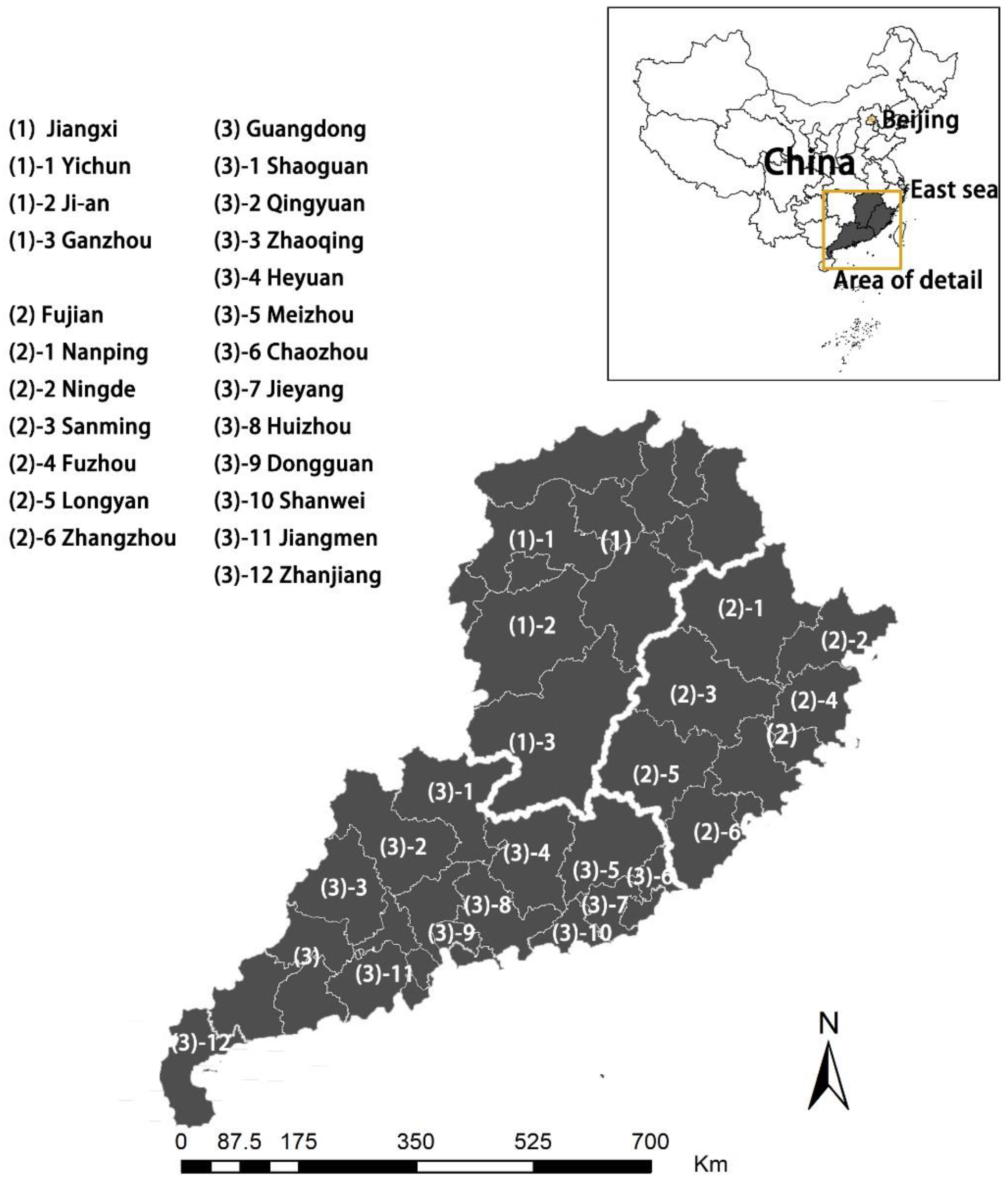
Jiangxi, Fujian, and Guangdong are considered the “formation area” for Hakka villages. There were three primary reasons for selecting these three sites as the study area. First, these sites are among the earliest locations of migration with a deep recorded history. Second, the large number of people who have migrated to these sites have formed sufficiently large clusters. Third, many Hakkas have passed through Jiangxi, Fujian, and Guangdong and have then moved on to other provinces. Therefore, the Hakka traditional villages in the regions of Jiangxi, Fujian, and Guangdong serve as suitable research sites for this study. The study area is shown in Figure 2.

2.2. Data Resources

2.2.1. Method of Selection of Hakka Village Listings in Fujian, Guangdong, and Jiangxi

In “A Study of the Origin and Flow of Hakka”, it is stated that, “The Hakka are a systematic and distinct branch of the Han Chinese, not an inherent people group in southern China, and their language and customs are not the same as those of their neighbors” [1] (p. 12). The following information was extracted from the text of Luo Xianglin [1]: (1) The Hakka are a branch of Han Chinese, which can be ethnically qualified; (2) the Hakka experience ethnic migration, which is geographically qualified; and (3) the Hakka have their own language and culture, which is qualified. Based on the above criteria, we created a list of Hakka traditional villages from the traditional villages announced by the national and local governments; a total of 178, 135, and 50 villages in Fujian, Guangdong, and Jianxi, respectively, were designated as Hakka villages.

2.2.2. Data Extraction of Influencing Factors

To achieve the protection of the overall environment of Hakka traditional villages in Fujian, Guangdong and Jiangxi, it is necessary to first understand the symbiosis between the residents of these village and the surrounding environment. This is reflected in the degree of importance that the residents attach to different environmental factors. Commonly used impact factors include roads [52], water systems [53], vegetation [54,55,56], topography [57], climate [58], and the economy [59]. The economic factor is mostly used to study changes in the long-term development status of the target, which is not consistent with the transient behavior of site selection and was therefore excluded from the present study. The climate factor was also excluded from the present study owing to its episodic nature.
The data sources for each influencing factor were obtained from Rivermap [60] and USGS, with the elevation, slope, and slope direction obtained from satellite remote sensing raster data provided by the Rivermap software. The remotely sensed vegetation cover data were downloaded from the USGS website, and, to facilitate calculation, were resampled to 4-band remote sensing images with 1 km resolution. Then, the NDVI formula was used to calculate the results through ENVI (version 5.3, Exelis Visual Information Solutions, Broomfield, CO, USA). Water system distance and road distance vector data were obtained from the Rivermap software. In this study, highways, national roads, provincial roads, county roads, and railroads, which are relatively stable, were selected as the reference objects of the study, and the road networks were combined. There were two reasons for not selecting country roads as reference objects: (1) country roads and other minor roads are partly located in villages, and this study did not investigate spatial structure unit connectivity under the influence of road networks within villages; and (2) many country roads are dirt roads, which are randomly distributed and unstable. The water system data in this study only contained information on water systems that were visible on the map and did not include artificial water systems, such as small diversion ditches.

2.3. Analysis Method

2.3.1. Kernel Density Estimation

Kernel density analysis can visualize the “hotspots” in the spatial distribution of villages and reflect density changes in village distribution [61]. Kernel density estimation is based on the assumption that geographic events can occur at any location in space, that the probability of occurrence of points differs at different locations, and that the probability of occurrence of events in areas with dense points is high, and vice versa. The expression for the nuclear density is given by:
f o x = 1 n h i = 1 k x X i h
where f denotes the distribution density function, f (x) is the kernel density value at point x, k ( x X i h ) is the kernel function, (x − Xi) refers to the distance between point x and event X i ; and h is the bandwidth, h > 0. The kernel density was determined using the ArcGIS software (version 10.6, ESRI, Redlands, CA, USA) “kernel density analysis” tool which was used in the present study to visualize the distribution of Hakka traditional villages in Fujian, Guangdong, and Jiangxi.

2.3.2. Nearest Neighbor Index

In nature and society, there are three types of point-like elements: random, uniform, and agglomerative distributions. These three types can be discriminated using the nearest-neighbor distance and nearest-neighbor index. This index determines the distance, r1, between each point and its nearest neighbor, and then takes the average of all the distances, r ¯ 1 , which represents the nearest-neighbor distance that characterizes the degree of proximity [62].
r ¯ E = 1 2 n / A = 1 2 D  
Here, r ¯ E is the theoretical nearest-neighbor distance, n represents the number of point cells, A is the total area of the study area, and D is the density of the point cell. The nearest point index, R, is the ratio of the actual nearest point distance and the theoretical nearest point distance, and the expression is as follows:
r ¯ 1 r ¯ R = 2 D r .
When R = 1, r ¯ 1 = r ¯ R , indicating that the point cell distribution is of the random type. When R > 1, r ¯ 1 > r ¯ R , indicating that the point cells tend to be uniformly distributed. When R < 1, r ¯ 1 < r ¯ R , indicating that the point cells tend to be clustered and distributed. This study corroborated the distribution status of Hakka traditional villages in Fujian, Guangdong, and Jiangxi by calculating the nearest point index.

2.3.3. Superposition Analysis Method

Superposition analysis is a method that overlaps two or more groups of elements in the same area to produce new features [63]. In this study, the geographic location information of traditional villages, a digital elevation map (DEM), spatial data of the water system, spatial data of roads, and vegetation distribution status were overlaid in ArcGIS to analyze the distribution of traditional villages and the interrelationship between the elements, as well as to analyze the distribution characteristics of Hakka villages in Fujian, Guangdong, and Jiangxi and the site selection culture of Hakka people.

2.3.4. Correlation Matrix Analysis of Dependent Variables

The dependent variable correlation matrix represents the correlation coefficients between two multiple variables. The factor interaction significance and correlation coefficient magnitude were also calculated. Plotting of the dependent variable matrices was achieved through the GGally program package in the R language (version 1.4.1717, AT&T Bell Laboratories, Auckland, New Zealand).

2.3.5. Geodetectors

Geodetectors are a set of statistical methods that detect spatial differentiation to reveal the driving forces behind it [64]. The core concept is based on the assumption that, if an independent variable has a significant effect on a dependent variable, then the spatial distribution of the independent and dependent variables should have similarities [65,66]. We explored the factor gradient of the site selection of Fujian–Guangdong–Jiangxi Hakka traditional villages using divergence and factor detection. Subsequently, interactions were detected based on divergence and factor detection to analyze the interaction between two influencing factors, indicating whether the interaction of factors was promoting or suppressing the site selection of villages.
The divergence and factor detection expressions are as follows:
q = 1 h = 1 L N h σ h 2 N σ 2 = 1 S S W S S T ,  
where the value domain of q is [0, 1], assuming that Y is spatially divergent. X is a factor, and the divergence and factor detection indicate how far factor X can explain the spatial divergence of attribute Y. A higher q value indicates that the explanatory power of the independent variable X on Y is stronger, and a lower q value indicates that it is weaker. The extreme case where q = 1 indicates that the spatial distribution of Y is entirely due to factor X; whereas q = 0 indicates that the spatial distribution of Y is unrelated to factor X.

3. Results

3.1. Distribution Characteristics of Hakka Villages in Fujian, Guangdong, and Jiangxi

Analysis of the Distribution of Hakka Villages in Fujian, Guangdong, and Jiangxi

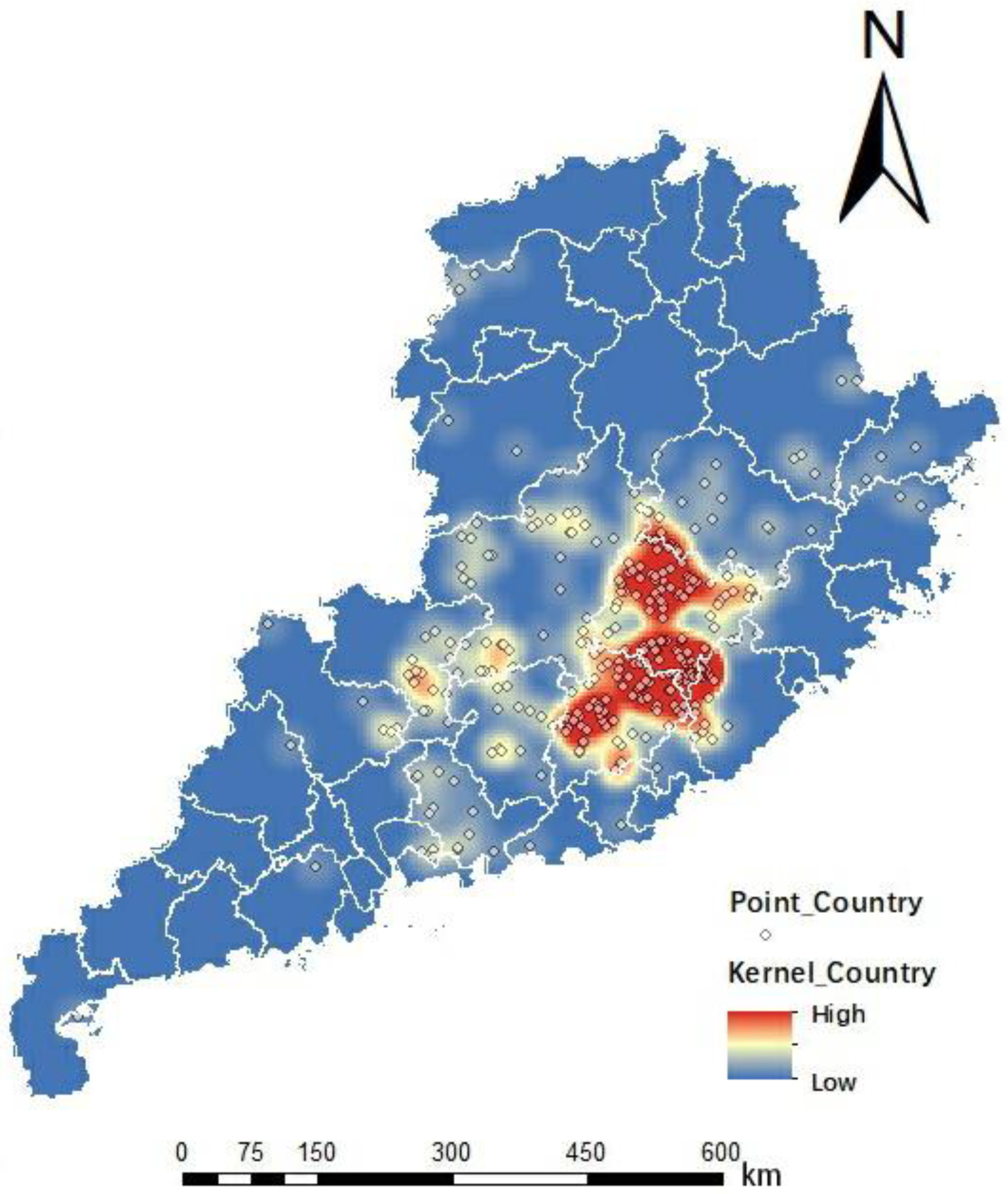
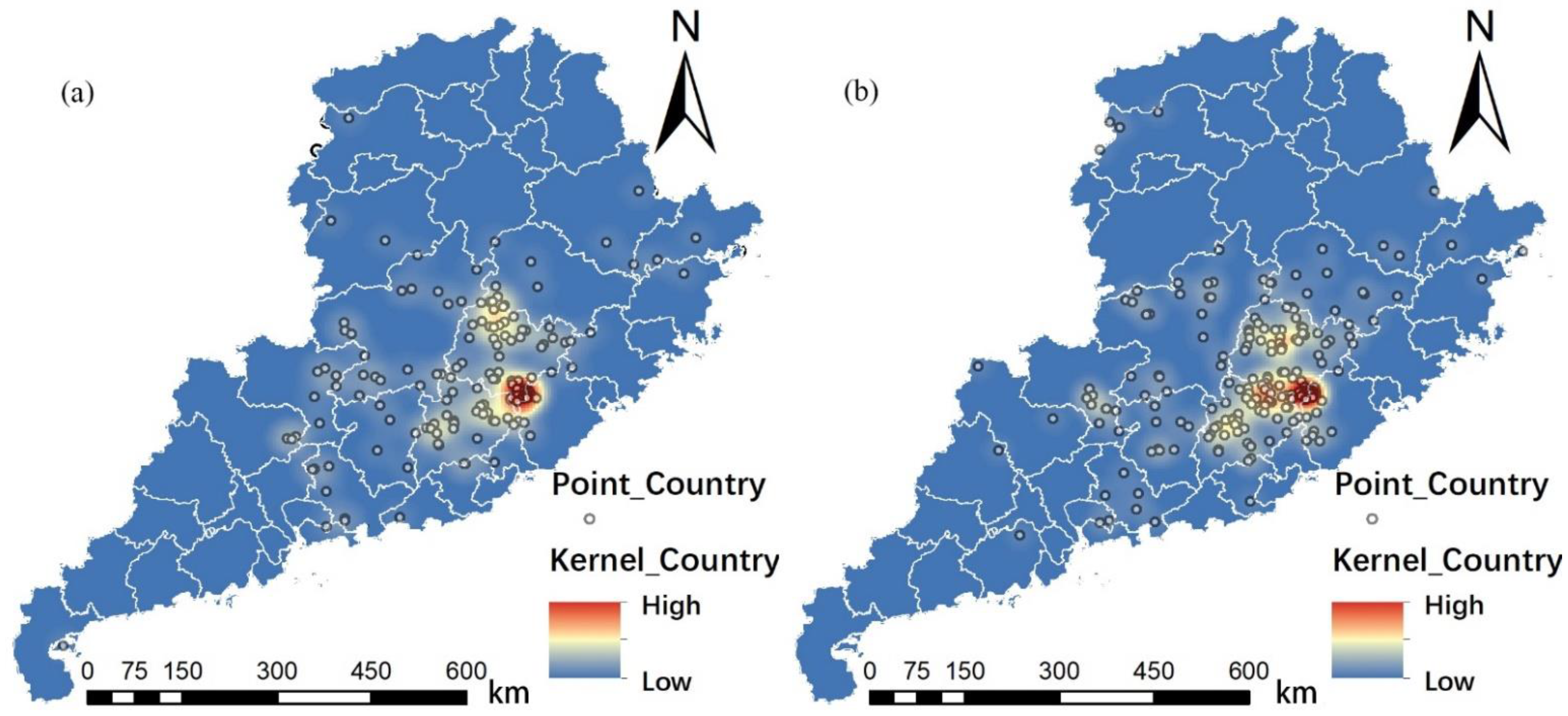
Based on the village coordinates of the listed villages and the kernel density analysis using ArcGIS, the distribution of Hakka traditional villages in Fujian, Guangdong, and Jiangxi was obtained, as shown in Figure 3. Based on the kernel density analysis, the main clusters of Hakka traditional villages were found to be in western Fujian, eastern Guangdong, and southern Jiangxi; several secondary clusters were also identified in central Guangdong and northwestern Jiangxi, along with scattered Hakka villages in northeastern Fujian and western Guangdong.
The mean nearest neighbor tool was used to calculate the result of p < 0.0001 and the z value = −16.90546, where the p-value is the probability of a random distribution and the z value represents the distance between the measured value and the overall mean, as a multiple of the standard deviation. When R = 0.536187, the nearest-neighbor index R value was between 0 and 1, indicating that the distribution of Fujian–Guangdong–Jiangxi Hakka traditional villages was significantly clustered.
Many previous studies have illustrated the approximate distribution of Hakka traditional villages through textual description, and effective visualization of villages is limited to those studies with municipal units as boundaries, such as Ganzhou and Meizhou. We systematically analyzed and visualized the distribution status of Hakka traditional villages in Fujian, Guangdong, and Jiangxi provinces, and discovered several new Hakka distribution clusters based on the well-known major distribution clusters.
The distribution conditions could be divided into three types, namely, random distribution, uniform distribution, and agglomeration distribution. The obvious clustering of Hakka traditional villages not only indicates that their distribution is regular, but also that the current distribution is the result of subjective intervention under the influence of the same culture. The reasons for the large-scale clustering of Hakka traditional villages may either be the superordinate natural environment and favorable base sites for the future development of the villages or grouping for defense against foreign enemies under specific historical conditions.

3.2. Influencing Factors

3.2.1. Elevation Factors

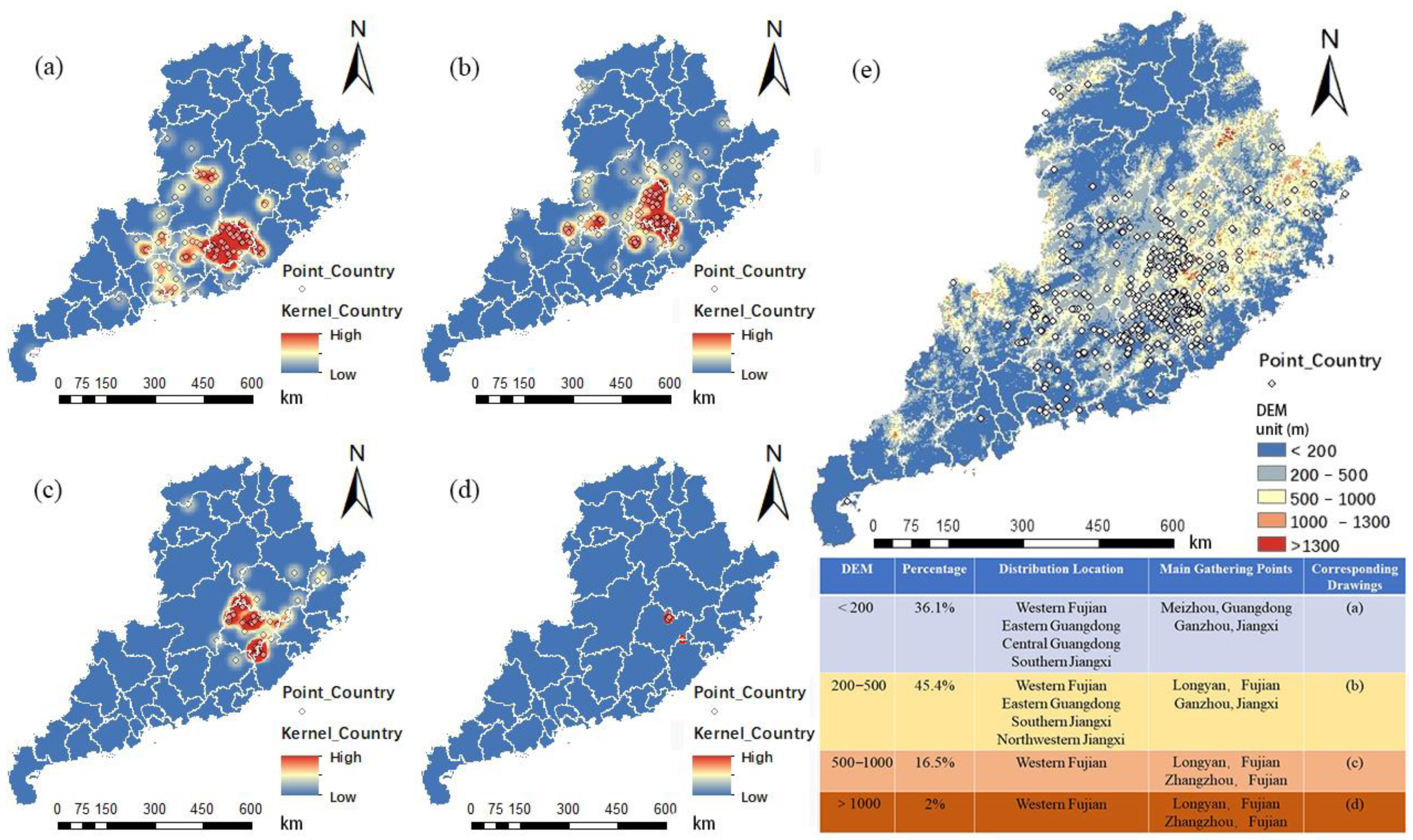
The distribution data of Hakka traditional villages were overlaid with the elevation data of Fujian, Guangdong, and Jiangxi, and the elevation value of each village was obtained using the coordinates of the ArcGIS projection points. The overlaid map of the distribution and elevation of Hakka traditional villages in Fujian, Guangdong, and Jiangxi could then be drawn (Figure 4e). Then, according to the “China 1:1,000,000 Geomorphology Mapping Standard”, the undulation of China’s mountainous areas was divided into five levels: 200, 500, 1000, and 2500 m [67], and the villages were reclassified according to this standard. The distribution of villages at different elevations is shown in Figure 4.
According to the data shown in the figure, Hakka villages with elevations between 200–500 m above sea level dominated, followed by villages with elevations below 200 and 500–1000 m, and those above 1000 m. This indicates that, in ancient times, Hakka people were foreigners compared to the indigenous inhabitants of Fujian, Guangdong, and Jiangxi, and their site selection lagged behind. This limited Hakka villages to areas above 200 m in elevation, i.e., the Hakka groups that failed to locate at low elevation retreated to areas between 200–500 m in elevation. The Hakka people, thus, did not prefer to live at high altitudes, but were forced to.

3.2.2. Slope and Slope Orientation

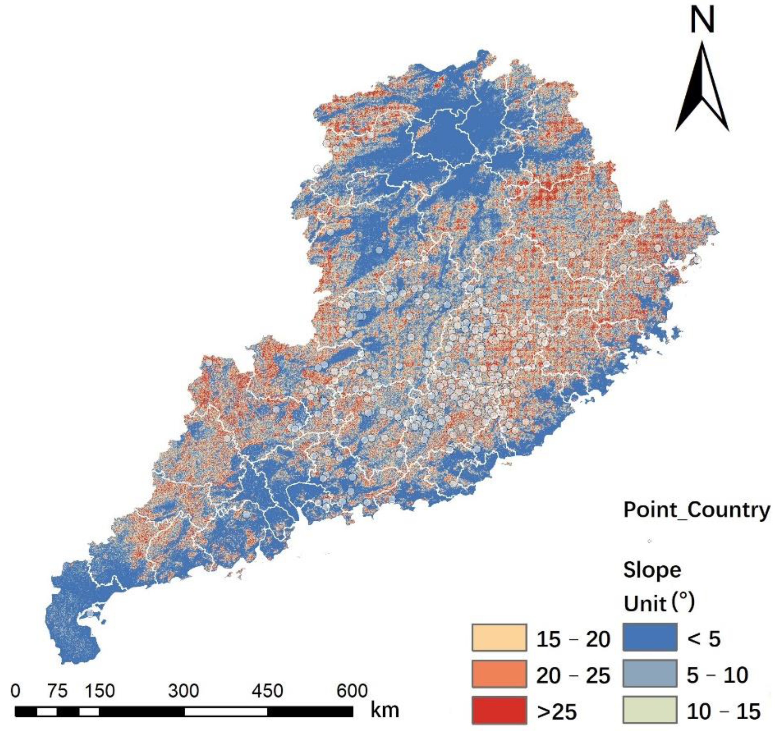
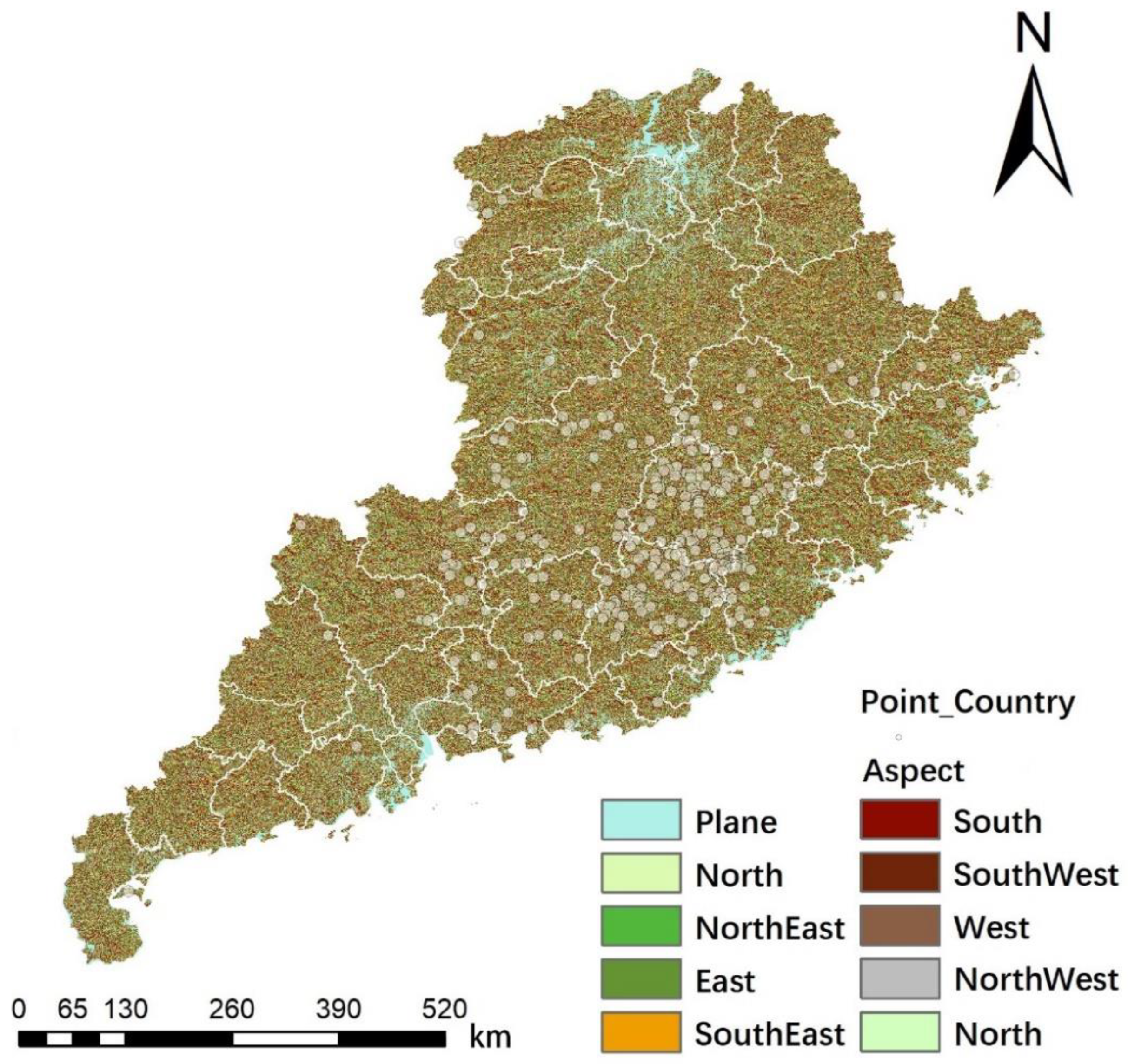
The slope refers to the steepness of the ground surface, and the slope direction is the orientation of the local surface slope in three-dimensional space [68]. Because the elevation can only objectively show the elevation of the target village, but not the topography of the village, it was necessary to use the slope and slope direction to measure the undulation of the topography of the base site of the village. The village distributions with the superposition of slope and slope direction are shown in Figure 5 and Figure 6.
  • Slope
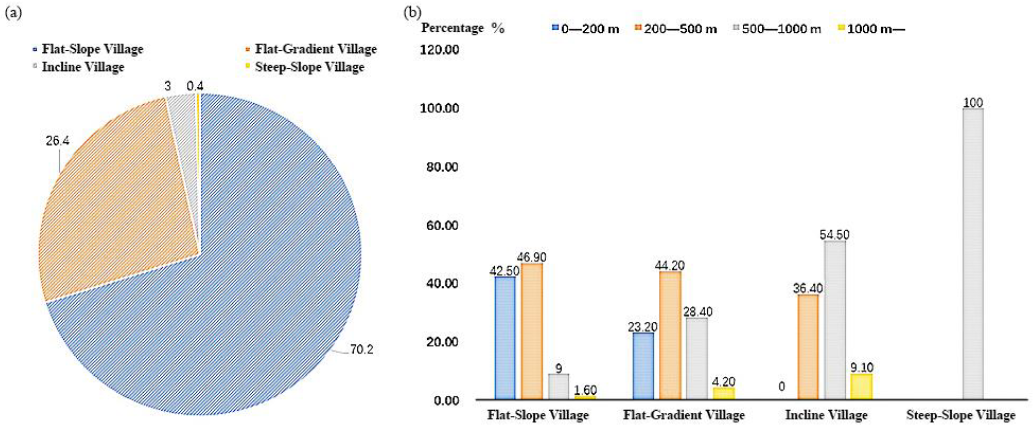
According to the slope classification standard, 0–5° is a flat slope, 6–15° is a gentle slope, 16–25° is a slope, and 26–35° is a steep slope. The statistical analysis of Hakka traditional villages in Fujian, Guangdong, and Jiangxi is shown in Figure 7, and the distribution analysis is shown in Figure 8.
  • Slope orientation
Using the ArcGIS tool for slope orientation analysis and the “Add surface information” tool to obtain the slope orientation data of Hakka traditional villages in Fujian, Guangdong, and Jiangxi, we identified a total of 206 villages (56.7%) located on sun-facing slopes (90–270°) (Figure 9a), 155 villages (42.7%) located on shady slopes (0–90°, 270–360°) (Figure 9b), and two villages on flat land (0° slope).
Based on the data shown in Figure 7, the majority of Hakka traditional villages were located on flat slopes, where the less undulating terrain can greatly reduce the cost of establishing a village foundation and better meet the needs of daily production. Although the slope direction directly affects the light conditions and has an impact on crop production, the number of Hakka traditional villages located on shady and sunny slopes was relatively similar, which is a result of the fact that most of the villages were located on flat slopes, as the bases of the villages were built on relatively flat land and the light conditions were hardly affected.

3.2.3. Distance from Road and Water Systems

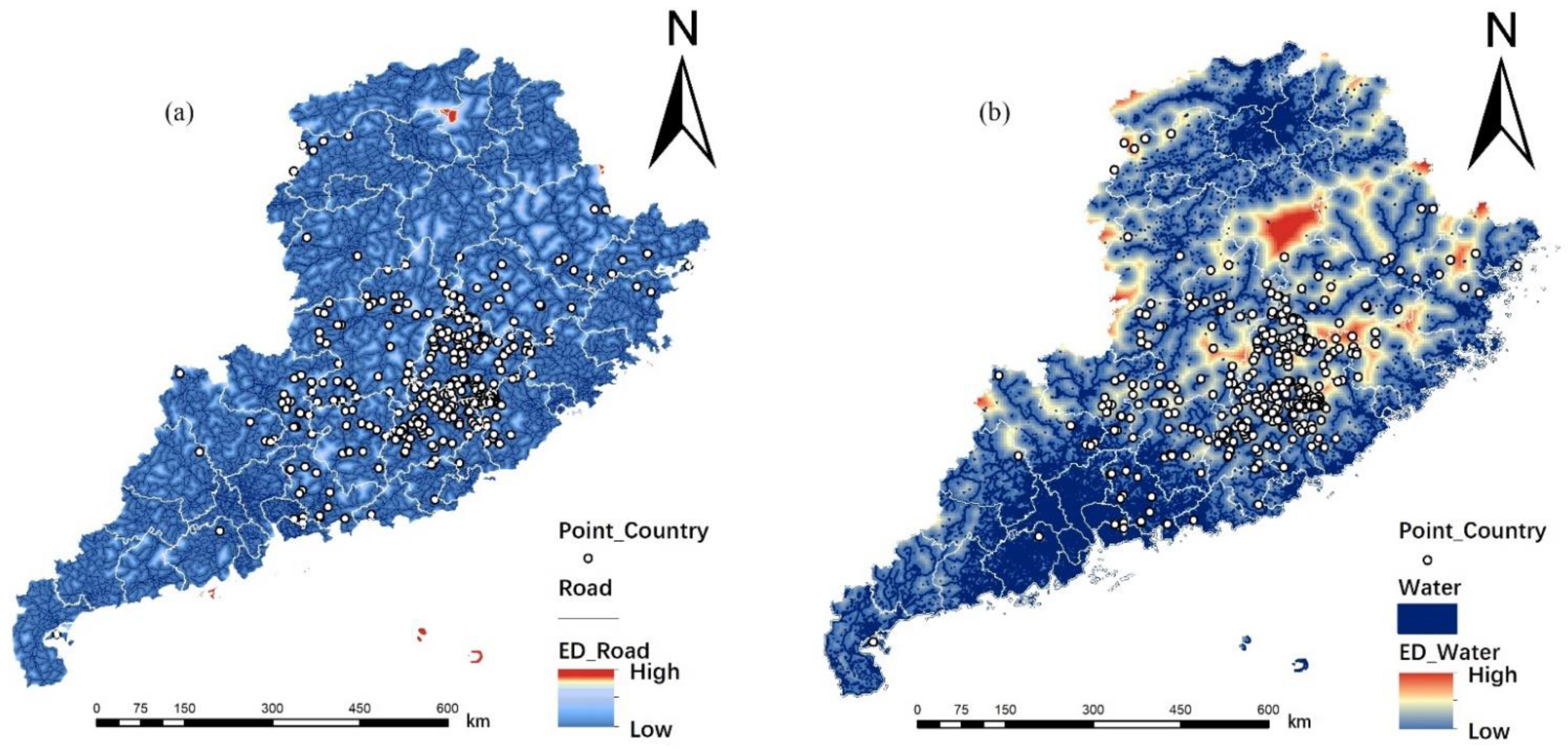
The influence of the distance between individual Hakka villages in Fujian, Guangdong, and Jiangxi on the location of villages was explored by considering individual villages as a unit. The final map of the road buffer analysis of Fujian–Guangdong–Jiangxi Hakka traditional villages is shown in Figure 10a.
Water systems not only provide a reliable water source for Hakka traditional villages, but also served a transportation function in ancient times and are considered to be closely related to the development of villages. The final buffer analysis map of Fujian–Guangdong–Jiangxi Hakka traditional water systems is shown in Figure 10b.
  • Distance to Land Transportation
The Euclidean distance from roads to each village was calculated using ArcGIS, and the results were divided into three intervals, with 0–1 km being convenient, 1–5 km being moderate, and >5 km being distant. A total of 238 villages (65.6%) were located within 1 km of the main roads (Figure 11a), 100 villages (27.5%) were located between 1 and 5 km of the main roads (Figure 11b), and 25 villages (6.9%) were located >5 km from main roads (Figure 11c).
  • Water System Distance
Rivers not only provide abundant water sources for the surrounding Hakka villages, but also provide the Hakka villages with their main water transportation routes. The water systems of Fujian–Guangdong–Jiangxi provinces were extracted using the Shui Jing Zhu software, which downloads all online maps published as tiles and performs large map stitching, map re-projection, tile re-slicing, map annotation, vector download, and vector overlay; then, the “Extract values to points” tool was used to obtain the distance between a village and the nearest water system with the help of the Euclidean distance function of ArcGIS. Buffer zones of 5 and 15 km were taken for the water system, and the Hakka traditional villages in Fujian–Guangdong–Jiangxi between different buffer zones were analyzed for nuclear density. The numbers of villages within the 5, 15, and >15 km buffer zones represented 39.1% (Figure 12a), 33.1% (Figure 12b), and 27.8% (Figure 12c) of the total, respectively.
In ancient times, traditional villages relied heavily on water sources due to the lack of modern technology for pipe network facilities. This is also true for Hakka traditional villages, and the results of the statistical data analysis confirm this view. However, the road system was not well developed in ancient times, and villages located far away from roads were common. Since the construction of roads is easier to achieve through artificial means than alteration of other influencing factors, it needs to be verified whether the distance between village and road is an important influencing factor.

3.2.4. Vegetation Cover

The NDVI, an important parameter reflecting vegetation growth and nutrient information, was used as the basis for ecological evaluation. The mean value of the NDVI index of the 1-km buffer zone centered on the village was extracted using the “Show zoning statistics in table” tool in ArcGIS, and the average NDVI index of each village was finally obtained (Figure 13).
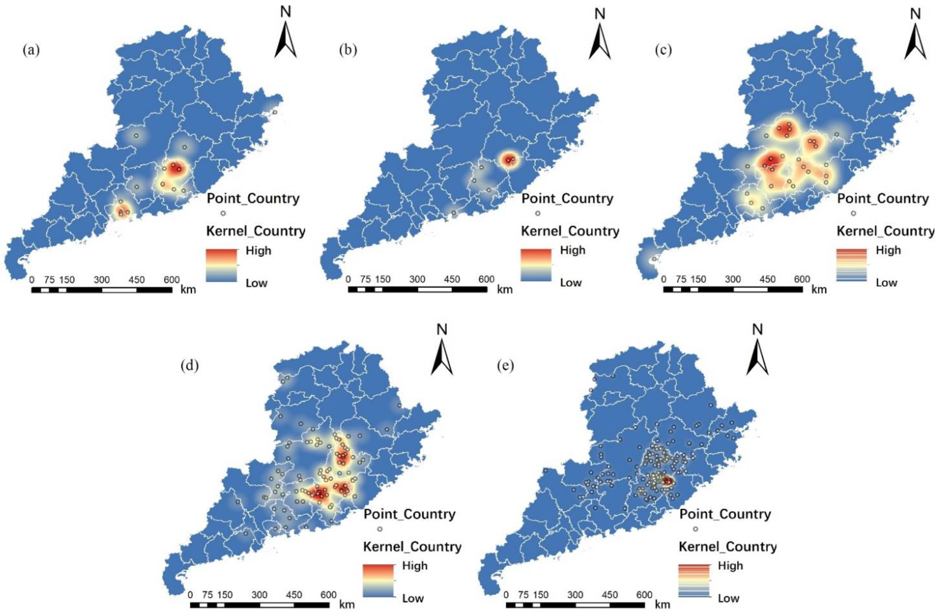
The obtained results were classified into five classes: Class I (NDVI < 0.5), Class II (0.5 < NDVI < 0.6), Class III (0.6 < NDVI < 0.7), Class IV (0.7 < NDVI < 0.8), and Class V (NDVI > 0.8), with higher NDVI indices representing a superior ecological environment. The results showed that Class I, II, III, IV, and V villages accounted for 4.7% (Figure 14a), 2.2% (Figure 14b), 8.0% (Figure 14c), 28.1% (Figure 14d), and 57.0% (Figure 14e) of the total, respectively.
Rich resources can entail living and production advantages for Hakka traditional village residents, so the higher the vegetation richness, the more Hakka traditional villages there were, which is in accordance with the law of nature.

4. Discussion

Although the distribution status of Hakka traditional villages in Fujian, Guangdong, and Jiangxi varied under different influence factors, the status quo cannot be used as a basis for discriminating the strength of the influencing factors. Further validation is needed to discover and analyze the similarities and differences between the secondary and preliminary results. Two methods of validation were used in this study: one was to conduct factor correlation analysis using the R-studio software and derive the factor correlation matrix to explore the correlation between two factors; the other was the use of geographic probe software to perform divergence and factor detection, followed by interaction detection on the data results. Finally, we combined the results of both calculations to comprehensively evaluate the influence of each factor on Hakka site selection.

4.1. Correlation Matrix of Dependent Variables

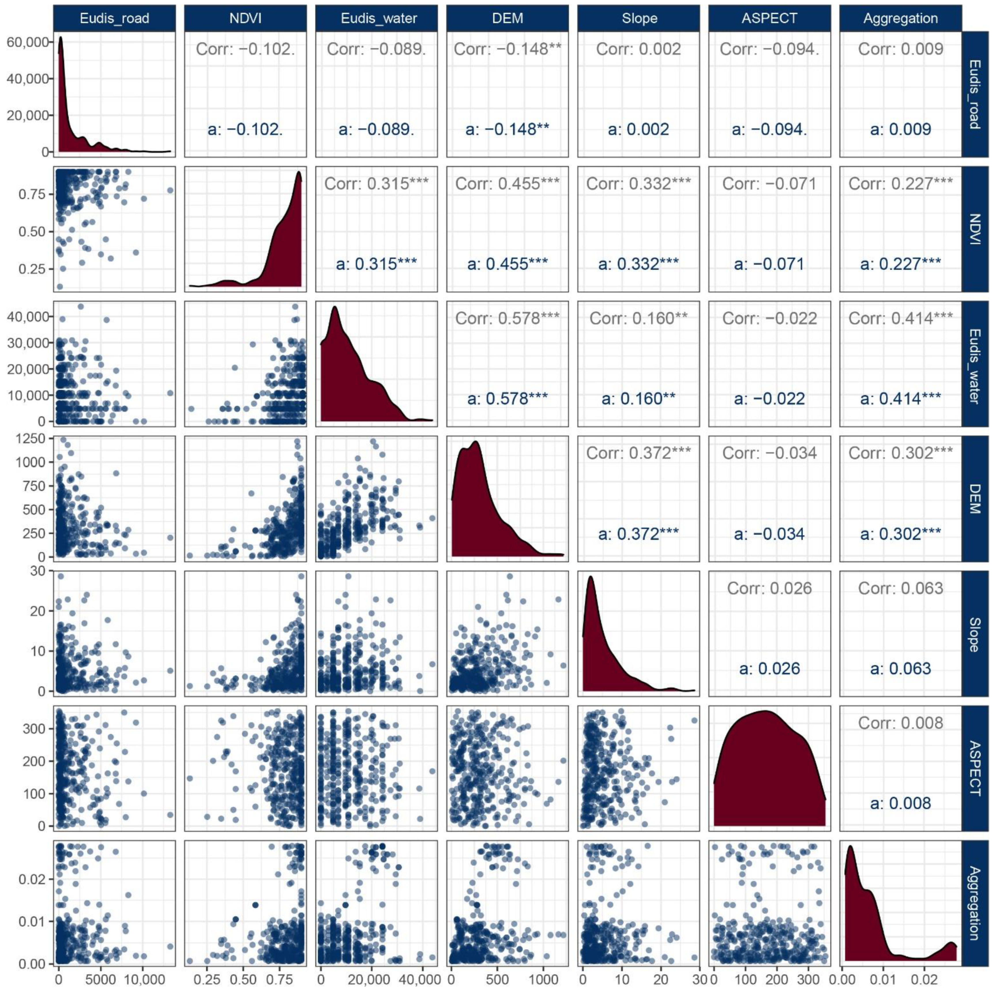
According to the matrix (Figure 15), most factors were significantly correlated with each other; however, slope direction did not significantly correlate with the other factors. Water distance, vegetation cover, and slope did not significantly correlate with land transportation distance, and slope did not significantly correlate with village aggregation. Among the factors with significant correlations, only roads negatively correlated with elevation, and all other factors were significantly positively correlated with each other. Among these, elevation was most closely related to water distance, with a correlation coefficient of 0.578. In terms of village aggregation, the most influential factor was water distance, with a correlation coefficient of 0.414.

4.2. Divergence and Factor Detection

The data of each factor extracted from ArcGIS were normalized and imported into Geodetector for calculation and the obtained results are shown in Table 1.
Based on the variance and factor detection results, the p-values indicate the confidence level of the influencing factors, of which the p-values of water system distance, vegetation richness, and elevation tended to be close to 0, indicating high significance. In contrast, the p-values of road distance, slope, and slope direction were all >0.05, indicating a lack of significant influence. In other words, the distances between the village and the water system, vegetation richness, and elevation all had a direct influence on the village location, whereas the road distance, slope, and slope direction were less relevant to the village location. The q value shows the degree to which the independent variable X is explained in relation to the dependent variable Y. According to the factor detection results, the degrees of influence of the factors on the location of a village were in the following order: water system distance > elevation > vegetation richness > land transportation distance > slope > slope direction.
The factor correlation matrix matched with the Geodetector results, which confirmed that the distances of water system, elevation, and vegetation cover were the main factors influencing the village locations, whereas the slope, slope direction, and road distance were not significantly related to the village locations.

4.3. Interaction Detection

Interaction detection was used to identify conditions under which the explanatory power of factor Y may be enhanced or diminished by different influencing factors acting together on the dependent variable Y. The results obtained through interaction detection are shown in Table 2.
The values generated by the intersection of the same factors in Table 2 are the q values in the divergence and factor detection. Taking q as the reference object, it was found that the values generated by the two-factor interaction were all >q, indicating that the interaction between the factors can promote the location of Hakka villages in the Fujian, Guangdong, and Jiangxi areas to establish their foundations. Although the factor interactions showed an enhancement trend in general, there were strong and weak interactions among different factors; the interactions had five intervals, corresponding to: non-linear weakening, single-factor non-linear weakening, two-factor enhancement, independent enhancement, and non-linear enhancement. The six factor interactions selected in this study were related to only two cases, i.e., the third and fifth intervals, corresponding to two-factor enhancement and non-linear enhancement, respectively. The obtained results are summarized in Table 3.
Two-factor enhancement refers to a two-factor interaction which is higher than the single value effect values; whereas non-linear enhancement refers to a two-factor joint effect which is higher than the sum of the single value effect values. A two-factor enhancement is represented by the formula q(X1∩X2) > Max (q(X1), q(X2)), whereas the formula for non-linear enhancement is q (X1∩X2) > q(X1) + q(X2). Table 3 shows that, although land transportation distance, slope, and slope direction were not the main factors influencing the location of Hakka villages, the combination of these three factors with the dominant factors, such as distance from the water system, elevation, and vegetation richness mostly produced good results. In contrast, when the dominant factors interacted with each other, the effect was not as great as the former, although the effect was stronger than the single-factor-generated effect.

5. Conclusions

Maslow’s hierarchy of needs theory divides human needs into deficiency needs and growth needs. Most of the existing Hakka studies focus on growth needs, such as architectural styles, costume patterns, and local songs and folklore. These things can be easily observed and summarized through images, texts, or physical landscapes, and the corresponding studies are more easily conducted due to the mature development of the research objects. On the other hand, site selection culture is related to basic survival and the subsequent development of Hakka traditional villages and is more obscure in its cultural expressions related to missing and growing needs. These are mentioned in some existing Hakka studies, which, however, use subjective textual descriptions and do not investigate Hakka traditional village site selection preferences based on data analysis. We thus extracted the distribution of Hakka traditional villages in Fujian, Guangdong, and Jiangxi provinces using ArcGIS and related this distribution to various influencing factors and their interactions. The conclusions are as follows.
1. Villages were mainly concentrated in western Fujian, eastern Guangdong, and southern Jiangxi, followed by small-scale concentrations in central Guangdong and northwestern Jiangxi, with scattered villages in northeastern Fujian and western Guangdong.
2. In terms of elevation, Fujian–Guangdong–Jiangxi Hakka tended to choose low hilly areas < 500 m. Hakkas attached importance to the location of water sources in establishing their base. The ecological environment of village sites was also valued, and the number of Hakka traditional villages was higher in areas of rich vegetation.
3. The multi-factor influence ranking of Fujian–Guangdong–Jiangxi Hakka traditional village sites was as follows: water distance > elevation > vegetation richness > land transportation distance > slope > slope direction.
4. Water, elevation and vegetation richness are the main influencing factors for Hakka site selection. Land transportation distance, slope and slope direction are the secondary factors influencing Hakka site selection. The interaction of secondary influencing factors with primary influencing factors also contributes significantly to Fujian–Guangdong–Jiangxi Hakka traditional village base site selection among the multi-factor interaction factors.
We conclude that Hakka site selection culture is an endogenous driving force supporting the development of Hakka traditional villages. Our results demonstrate the aggregation of Hakka traditional villages in Fujian, Guangdong, and Jiangxi provinces; visualize the natural distribution of Hakka traditional villages under the influence of different factors; determine the environmental factors to which the Hakka people attributed importance when choosing a location to build a village; and identify the role of multi-factor interactions on the village location selection of Hakka people. The focus of this study was on the convergence of the site selection of Hakka traditional villages. We argue that the importance of each influencing factor on the site selection of Hakka people is similar due to the common cultural background, but that Hakka traditional villages distributed in different regions needed to make adjustments in production and lifestyle to adapt to different local environments. Moreover, Hakka culture has also integrated with the local indigenous culture to varying degrees, which has resulted in differences among Hakka villages in different regions. This has led to some differences in the landscape presentation and cultural customs of Hakka villages. In future research, we will continue to explore the differences in culture and landscape presentation of Hakka traditional villages in different regions of Fujian, Guangdong, and Jiangxi from a multidisciplinary perspective, based on the findings of this study.

Author Contributions

Conceptualization, G.X. and C.L.; methodology, G.X.; software, G.X. and Y.Z.; validation, G.X. and C.L.; formal analysis, G.X.; investigation, G.X.; resources, G.X.; data curation, G.X.; writing—original draft preparation, G.X.; writing—review and editing, G.X.; visualization, G.X. and Y.Z.; supervision, C.L.; project administration, C.L.; funding acquisition, C.L. All authors have read and agreed to the published version of the manuscript.

Funding

This research was funded by the National Natural Science Foundation of China (grant number 51968026, 31660231, 52268012).

Informed Consent Statement

Informed consent was obtained from all subjects involved in the study.

Data Availability Statement

The data in this paper involved geographic coordinates, elevation, vegetation environment, water system, and road data of Hakka traditional villages in Fujian, Guangdong, and Jiangxi provinces. Among these, the list of Fujian–Guangdong–Jiangxi Hakka traditional villages consisted of 1115 national-level traditional Chinese villages in Fujian–Guangdong–Jiangxi provinces announced by the Ministry of Housing and Urban-Rural Development and other departments of China (http://www.chuantongcunluo.com/index.php/Home/Gjml/gjml/id/24.html, accessed on 25 October 2021); 917 provincial-level traditional villages in Fujian Province announced by the Ministry of Housing and Construction and other departments of Fujian Province (https://zjt.fujian.gov.cn/, accessed on 11 November 2021); 186 provincial-level traditional villages in Guangdong Province announced by the Ministry of Housing and Construction and other departments of Guangdong Province (http://zfcxjst.gd.gov.cn/xwzx/, accessed on 13 November 2021); and 248 provincial-level traditional villages in Jiangxi Province announced by the Ministry of Housing and Construction and other departments of Jiangxi Province(http://zjt.jiangxi.gov.cn/, accessed on 15 November 2021); a total of 348 Hakka traditional villages were finally extracted through layers of screening and elimination. Furthermore, based on the traditional Hakka villages selected at the national and provincial levels, 15 Hakka villages with well-preserved Hakka culture that were not listed as traditional villages for protection were included in the study by means of field research and data inquiries. Elevation data (DEM) were derived from the geospatial data cloud platform (http://www.gscloud.cn//, accessed on 20 November 2021). Administrative boundaries as well as road and water system data were derived from Rivermap (http://www.rivermap.cn/, accessed on 22 November 2021). The normalized difference vegetation index (NDVI) was derived from the USGS (the United States Geological Survey) platform (https://earthexplorer.usgs.gov/, accessed on 25 November 2021).

Conflicts of Interest

The authors declare no conflict of interest.

References

  1. Luo, X. A Study of the Origin and Flow of Hakka; China Overseas Chinese Publishing House: Beijing, China, 1989; Available online: http://book.jxcbelib.superlib.net/views/specific/2929/bookDetail.jsp?dxNumber=000001130847&d=FF69D64243E119D9B6BFE60468B43667&fenlei=08021306 (accessed on 2 March 2022).
  2. Zheng, L.; Li, Y.; Lu, S.; Bao, J.; Wang, Y.; Zhang, X.; Xue, H.; Rong, W. Physical characteristics of Chinese Hakka. Sci. China-Life Sci. 2013, 56, 541–551. [Google Scholar] [CrossRef]
  3. Lin, C.M.; Zhong, T.Y.; Liu, S.Q.; Zhong, Y.; Liu, L.P.; Lai, W.H.; Chen, X.Y.; Li, H.L. Analysis and prevention of gene mutation types of severe thalassemia in Hakka people in Gannan of Jiangxi Province. Exp. Hematol. 2020, 28, 2017–2021. [Google Scholar] [CrossRef]
  4. Chang, C.C. Hakka genealogical migration analysis enhancement using big data on library services. Libr. Hi Tech 2018, 36, 426–442. [Google Scholar] [CrossRef]
  5. Hua, L.; Chen, C.; Fang, H.; Wang, X. 3D documentation on Chinese Hakka Tulou and internet-based virtual experience for cultural tourism: A case study of Yongding County, Fujian. J. Cult. Herit. 2018, 29, 173–179. [Google Scholar] [CrossRef]
  6. Mu, Z.Y.; Yan, L. Study on the collection, arrangement and utilization of agricultural cultural heritage of Gannan Hakka. J. Ethnic Cult. 2020, 12, 110–116. [Google Scholar]
  7. Tao, J.; Chen, H.; Xiao, D. Influences of the natural environment on traditional settlement patterns: A case study of Hakka traditional settlements in eastern Guangdong Province. J. Asian Archit. Build. Eng. 2017, 16, 9–14. [Google Scholar] [CrossRef]
  8. Chen, L.Y.; Lian, W.H.; Bian, H. Analysis on the spatial distribution and origin of Hakka place-name cultural landscape. Sci. Surv. Mapp. 2019, 44, 70–77. Available online: https://kns.cnki.net/kcms/detail/detail.aspx?dbcode=CJFD&dbname=CJFDLAST2019&filename=CHKD201903012&uniplatform=NZKPT&v=pupJ1Yu0U28Sc5HpGsQxr5e9MYA_j6dQA-08fHGogyvbILTDFnP2rf_wKD7lj5sE (accessed on 23 June 2022).
  9. Li, J.W. The cultivation of ethics and morality in the ancient Hakka ancestral halls of Meizhou. Arch. Soc. 2017, 156–158. [Google Scholar]
  10. Liu, D. The beliefs of King Min in the Hakka region of western Fujian. Fujian Trib. (Human. Soc. Sci. Mon.) 2017, 10, 117–124. [Google Scholar]
  11. Yan, S.H. The Hakka dialect in the perspective of ethnic identity. Jiangxi Soc. Sci. 2019, 39, 239–244. [Google Scholar]
  12. Zhuang, C.S. The classification and development of nominal suffixes -zi (子) and -zai (崽) in Hakka dialects. Stud. Chin. Lang. 2020, 1, 66–76+127. [Google Scholar]
  13. Lee, W.S.; Zee, E. Hakka Chinese. J. Int. Phon. Assoc. 2009, 39, 107–111. [Google Scholar] [CrossRef]
  14. Chang, C.C.; Liao, C.H. Developing a context-aware annotation system for Hakka culture-specific language learning. Libr. Hi Tech 2017, 35, 445–457. [Google Scholar] [CrossRef]
  15. Zhang, X.; Lai, D.M. Investigation and reflection on the survival status of Fujian Hakka opera troupes. Chin. Theatre 2020, 4, 90–91. Available online: https://kns.cnki.net/kcms/detail/detail.aspx?dbcode=CJFD&dbname=CJFDLAST2020&filename=XIJU202004037&uniplatform=NZKPT&v=p-wSkOsM2G-ZI_Vdw8npXzc0knmd3k7cIlHdAo1dzPyTfDLckggxXoEJhmf6QR31 (accessed on 2 March 2022).
  16. Wang, S. The hundred-year vigil of the Hakka string puppet show in Liancheng. West. Fujian Chin. Theatre 2019, 8, 90–91. Available online: https://kns.cnki.net/kcms/detail/detail.aspx?dbcode=CJFD&dbname=CJFDLAST2019&filename=XIJU201908035&uniplatform=NZKPT&v=hdZ8CmHGGifZJmkrvueIuav1bmtLbDYDJ3yGRA7rnxoXY8gCkAGSBzFZ4Isl1WQ7 (accessed on 2 March 2022).
  17. Liu, Y.J.; Chen, D.S. Research on embroidery patterns of Hakka’s traditional costumes. J. Textile Res. 2012, 33, 114–117. Available online: https://kns.cnki.net/kcms/detail/detail.aspx?dbcode=CJFD&dbname=CJFD2012&filename=FZXB201207024&uniplatform=NZKPT&v=ejrQ25eskdFCW9Ujw3Ut1cFxbfsY8UEzwY-6T0naYu47KlIfBOsJnCOmjxRoE8GE (accessed on 24 June 2022).
  18. Xiao, Y.S.; Mei, Q. An investigation of the historical value of Hakka earth buildings in Bayu Area: The case study of Qu’s building in Dashun, Fuling, Chongqing. Reg. Archit. Cult. 2021, 246–247. Available online: https://kns.cnki.net/kcms/detail/detail.aspx?dbcode=CJFD&dbname=CJFDLAST2021&filename=JZYW202110094&uniplatform=NZKPT&v=qSZIZKyJ9zmhhduBwBg_zbkjWp91QOPRmEIL8oC0eoCVUTQDMiHtY7tiQKQzrFOf (accessed on 1 March 2022).
  19. Jiang, F. Ganan Guanxi Xinwei architecture and culture. Archit. Cult. 2020, 36, 173–174. [Google Scholar]
  20. Lowe, K.D. Heaven and earth-sustaining elements in Hakka Tulou. Sustainability 2012, 4, 2795–2802. [Google Scholar] [CrossRef]
  21. Luo, Y.; Yin, B.; Peng, X.; Xu, Y.; Zhang, L. Wind-rain erosion of Fujian Tulou Hakka earth buildings. Sust. Cities Soc. 2019, 50, 101666. [Google Scholar] [CrossRef]
  22. Ueda, M. A preliminary environmental assessment for the preservation and restoration of Fujian Hakka Tulou complexes. Sustainability 2012, 4, 2803–2817. [Google Scholar] [CrossRef] [Green Version]
  23. Zhuo, X.L.; Xaio, D. A study on the development logic of the morphotype of Hakka vernacular residence and its geo-spatial distribution patten in the border area of Jiangxi, Fujian, and Guangdong based on a novel method of universal survey. Archit. J. 2020, S2, 16–22. Available online: https://kns.cnki.net/kcms/detail/detail.aspx?dbcode=CJFD&dbname=CJFDLAST2020&filename=JZXB2020S2003&uniplatform=NZKPT&v=o0Oc0K45_RkEM3Rs0ocilDVoftLAlfLwMmO388vrkrPZE5olnbVsBxocYCyQHaMi (accessed on 2 March 2022).
  24. Pan, Y.; Cai, M.F.; Shi, Y. The analysis of the characteristics of traditional settlement landscape of Hainan lsland ethnic group based on language zone. Chin. Landsc. Archit. 2020, 36, 41–46. Available online: https://kns.cnki.net/kcms/detail/detail.aspx?dbcode=CJFD&dbname=CJFDLAST2021&filename=ZGYL202012008&uniplatform=NZKPT&v=Lj31kjFcyFsb1werRMq92KFC1W8tjWOAj4-e28cy8BoRuUBv6zjJaTAhdr2-TGTd (accessed on 2 March 2022).
  25. Liu, P.L.; Liu, C.L.; Deng, Y.Y.; Shen, X.Y.; Hu, Z.; Li, B.H. Study on the identification of Hakka traditional village’ s land-scape genes and analysis in the perspective of geography. Hum. Geogr. J. 2009, 24, 40–43. Available online: https://kns.cnki.net/kcms/detail/detail.aspx?dbcode=CJFD&dbname=CJFD2009&filename=RWDL200906012&uniplatform=NZKPT&v=o9wDQJYBUHp-nbGxsZVrI2yILL9_CTL-rKMSFQhpySk5QgNi5GDqOHnI2wdb0kwU (accessed on 2 March 2022).
  26. Wang, S. Experience of Hakka earth buildings to deal with water environment in mountainous areas. J. FuJian Univ. Technol. 2021, 19, 453–457. [Google Scholar]
  27. Wang, X.Q.; Liu, C.Q.; Jin, J.H. Research on the morphological characteristics and influencing factors of public space around Hakka villages in Southern Jiangxi Province: Case study of Li Yuen Wai in Jiangxi Province. Art Design 2019, 7, 108–111. [Google Scholar] [CrossRef]
  28. Zhang, L. Space types and deep structure of the Bailu ancient village in Ganxian County. J. Guangxi Univ.National. 2017, 39, 73–82. [Google Scholar]
  29. He, Y.; Chen, C.P.; Chou, R.J.; Luo, H.; Hou, J.S. Exploring the transformation in the “Spirit of Place” by considering the changed and unchanged defensive spaces of settlements: A case study of the Wugoushui Hakka settlement. Land 2021, 10, 490. [Google Scholar] [CrossRef]
  30. Liang, B.Q.; Ziao, D.W.; Tao, J.; Ji, J.J.; Zhuo, X.L.; Huang, Y. Spatiotemporal distribution and evolution of Hakka traditional villages in Ganzhou. Econ. Geogr. 2018, 38, 196–203. [Google Scholar] [CrossRef]
  31. Sun, Y.; Wang, Y.S.; Xiao, D.W.; Zhang, Q.B. The spatial distribution and evolution of Hakka traditional villages on GIS in Meizhou area. Econ. Geogr. 2016, 36, 193–200. [Google Scholar] [CrossRef]
  32. Jiao, S.; Zheng, Z.M.; Xu, F.; Li, C.L.; Li, H.; Ma, B. The “marginalized” characteristics of traditional village distribution: The case of Hunan Province. Geogr. Res. 2016, 35, 1525–1534. [Google Scholar]
  33. Jin, P.; Jun, L. Study on the spatial distribution of traditional villages and their influencing factors in Hubei Province. Hubei Soc. Sci. 2020, 11, 66–75. [Google Scholar] [CrossRef]
  34. Yang, Y.; Hu, J.; Liu, D.; Jia, Y.Y.; Jiang, L. Spatial structure identification and influence mechanism of Miao traditional villages in Guizhou Province. Econ. Geogr. 2021, 41, 232–240. [Google Scholar] [CrossRef]
  35. Huang, R.J.; Su, H.M.; Wei, Z.Y. Spatial distribution of traditional villages in Henan Province and its influencing factors. J. Shaanxi Normal Univ. (Nat. Sci. Ed.) 2019, 47, 98–105. [Google Scholar]
  36. Song, W.P.; Li, S.F.; Zhao, J.Y. Research on the evolution rule and influencing factors of spatial distribution of traditional villages in Shandong. Art Design 2018, 6, 136–137. [Google Scholar] [CrossRef]
  37. Qu, Y.; Jiang, G.; Zhao, Q.; Ma, W.; Zhang, R.; Yang, Y. Geographic identification, spatial differentiation, and formation mechanism of multifunction of rural settlements: A case study of 804 typical villages in Shandong Province, China. J. Clean. Prod. 2017, 166, 1202–1215. [Google Scholar] [CrossRef]
  38. Xiang, Y.; Cao, M.; Yan, F.; Sun, F. Study on spatio-temporal characteristics and protection strategies of traditional villages in Shaanxi Province. Urban Stud. 2019, 26, 27–32. [Google Scholar]
  39. Xu, J.; Yang, M.; Hou, C.; Lu, Z.; Liu, D. Distribution of rural tourism development in geographical space: A case study of 323 traditional villages in Shaanxi, China. Eur. J. Remote Sens. 2021, 54, 318–333. [Google Scholar] [CrossRef]
  40. Zhang, Z.R.; Tang, X.L. A study on environmental adaptability and characteristics of historical villages around the Taihu Lake area. J. Nanjing Forest. Univ. (Nat. Sci. Ed.) 2020, 44, 17–24. [Google Scholar] [CrossRef]
  41. Xue, M.Y.; Wang, C.X.; Dou, W.S.; Wang, Z.H. Spatial distribution characteristics of traditional villages in the Yellow River basin and influencing factors. J. Arid Land Resour. Environ. 2020, 34, 94–99. Available online: https://kns.cnki.net/kcms/detail/detail.aspx?dbcode=CJFD&dbname=CJFDLAST2020&filename=GHZH202004016&uniplatform=NZKPT&v=lBWQwEScAvENohwdBmRVV-jnfFO1pMJOBJpFqjq5so24fGGOBEbdPJcl_xiMHrVW (accessed on 2 March 2022).
  42. Liu, S.H.; Fan, H.Q.; Wang, Y.H.; Gao, X.H. Analysis on the spatial distribution characteristics and correlation of traditional villages in the Minjiang River basin. Mod. Urban Res. 2019, 9, 17–25. [Google Scholar] [CrossRef]
  43. Su, Q.; Hou, L.G.; Qiao, B. Study on spatial distribution characteristics and influencing factors of poverty villages in hilly area of Northwest Sichuan: A case study of Mianyang City. Southwest China J. Agricult. Sci. 2018, 31, 1927–1932. Available online: https://kns.cnki.net/kcms/detail/detail.aspx?dbcode=CJFD&dbname=CJFDLAST2018&filename=XNYX201809026&uniplatform=NZKPT&v=jBVJJ1WachxQhFgi-Xga0TdPsl6PolfvVLVdBiYd574UEbKlKaTuRpRAzYK-1XjX (accessed on 2 March 2022).
  44. Fen, S.; Yunying, R.; Miao, F. Spatial characteristics and influencing factors of traditional villages in Loess Plateau gully area: A case of national traditional villages in Yulin City of Shaanxi Province. Areal Res. Dev. 2021, 40, 162–168. [Google Scholar]
  45. Li, N.; Jiang, S. Study on spatial pattern of rural settlements in Wuling mountainous area based on GIS. Wirel. Pers. Commun. 2018, 102, 2745–2757. [Google Scholar] [CrossRef]
  46. Xu, J.; Shan, X.; Wei, A.; Wang, R.; Gao, X. Spatial distribution characteristics and influencing factors of rural settlements in Plateau Mountainous multi-ethnic gathering area. Wirel. Pers. Commun. 2020, 113, 633–650. [Google Scholar] [CrossRef]
  47. Kang, H.Y.; Zhang, J.H.; Hu, H.; Zhou, J.; Xiong, J. Analysis on the spatial distribution characteristics of Chinese traditional villages. Prog. Geogr. 2016, 35, 839–850. [Google Scholar] [CrossRef]
  48. Liu, A.L.; Ming, Q.Z.; Yang, C.Y.; Tan, S. Research on the relationship between the spatial distribution of traditional villages in Yunnan, Guizhou, and Guangxiand tourism development. Chin. J. Agric. Resour. Reg. Plan. 2021, 42, 166–177. [Google Scholar]
  49. Jiangsu, L.; Xiaorui, W.; Xiaojian, L. Spatial distribution characteristics and influencing factors of Chinese traditional villages. Econ. Geogr. 2020, 40, 143–153. [Google Scholar]
  50. Nan, G.; Chao, W.; Kai, B.; Yaofeng, M. Spatial differentiation and influencing factors of Chinese traditional villages. J. Shaanxi Normal Univ. (Nat. Sci. Ed.) 2020, 48, 97–107. [Google Scholar]
  51. Wu, C.; Chen, M.; Zhou, L.; Liang, X.; Wang, W. Identifying the spatiotemporal patterns of traditional villages in China: A multiscale perspective. Land 2020, 9, 449. [Google Scholar] [CrossRef]
  52. Bi, X.; Wang, H.; Ge, J. The changes of densities and patterns of roads and rural buildings: A case study on Dongzhi Yuan of the Loess Plateau, China. Environ. Monit. Assess. 2010, 164, 549–560. [Google Scholar] [CrossRef]
  53. Lee, H.S.; Nakai, Y. Effect of floods on village spatial structure and hierarchy—Hahoe Village, Korea. Landsc. Res. 2015, 40, 411–436. [Google Scholar] [CrossRef]
  54. Iwata, Y.; Fukamachi, K.; Morimoto, Y. Public perception of the cultural value of Satoyama landscape types in Japan. Landsc. Ecol. Eng. 2011, 7, 173–184. [Google Scholar] [CrossRef]
  55. Skowronek, E.; Krukowska, R.; Swieca, A.; Tucki, A. The evolution of rural landscapes in mid-eastern Poland as exemplified by selected villages. Landsc. Urban Plan. 2005, 70, 45–56. [Google Scholar] [CrossRef]
  56. Domon, G. Landscape as resource: Consequences, challenges and opportunities for rural development. Landsc. Urban Plan. 2011, 100, 338–340. [Google Scholar] [CrossRef]
  57. Kim, G.; Kang, W.; Park, C.R.; Lee, D. Factors of spatial distribution of Korean village groves and relevance to landscape conservation. Landsc. Urban Plan. 2018, 176, 30–37. [Google Scholar] [CrossRef]
  58. Alam, M.F.; Sikka, A.K. Prioritizing land and water interventions for climate-smart villages. Irrig. Drain. 2019, 68, 714–728. [Google Scholar] [CrossRef]
  59. Xiaoxiao, J.; Cancan, Y.; Mingwei, Z.; Yan, X.; Demin, Z.; Yuwei, Z. Spatial distribution characteristics and influencing factors of traditional villages in Zhejiang, Anhui, Shaanxi, Yunnan Provinces. Econ. Geogr. 2022, 42, 222–230. [Google Scholar]
  60. Shui Jing Zhu GIS. Available online: http://www.rivermap.cn/down.html (accessed on 8 August 2022).
  61. Liu, L.; Jiang, C.; Zhou, S.H.; Liu, K.; Xu, C.; Cao, J.J. Spatial-temporal patterns of burglary at multiple scales: The case of DP Peninsula in H city, China. Geogr. Res. 2017, 36, 2451–2454. [Google Scholar]
  62. Seamon, D. Phenomenology and vernacular lifeworlds. Trumpeter 1991, 8, 201–206. [Google Scholar]
  63. Fenghua, W. Fundamentals of Geographic Information Systems; Wuhan University Press: Wuhan, China, 2014; Available online: http://book.jxcbelib.superlib.net/views/specific/2929/bookDetail.jsp?dxNumber=000015423331&d=CE1DFD3A711A66DB8B1AB30A4020A254&fenlei=14020207 (accessed on 2 March 2022).
  64. Wang, J.F.; Xu, C.D. Geodetector: Principle and prospective. Acta Geogr. Sin. 2017, 72, 116–134. [Google Scholar]
  65. Wang, J.F.; Li, X.H.; Christakos, G.; Liao, Y.L.; Zhang, T.; Gu, X.; Zheng, X.Y. Geographical detectors-based health risk assessment and its application in the neural tube defects study of the Heshun Region, China. Int. J. Geogr. Inf. Sci. 2010, 24, 107–127. [Google Scholar] [CrossRef]
  66. Wang, J.F.; Hu, Y. Environmental health risk detection with GeoDetector. Env. Model. Software 2012, 33, 114–115. [Google Scholar] [CrossRef]
  67. Zhou, C.H.; Cheng, W.M.; Qian, J.K.; Li, B.Y.; Zhang, B.P. Research on the Classification System of Digital Land Geomorphology of 1:1 000 000 in China. J. Geo-info. Sci. 2009, 11, 707–724. [Google Scholar] [CrossRef]
  68. Riwen, L. 3S Technology Practice Tutoria; Zhejiang University Press: Hangzhou, China, 2014; Available online: http://book.jxcbelib.superlib.net/views/specific/2929/bookDetail.jsp?dxNumber=000015301267&d=8E05979988B33E6DF3F557595521ABE3&fenlei=181706 (accessed on 2 March 2022).
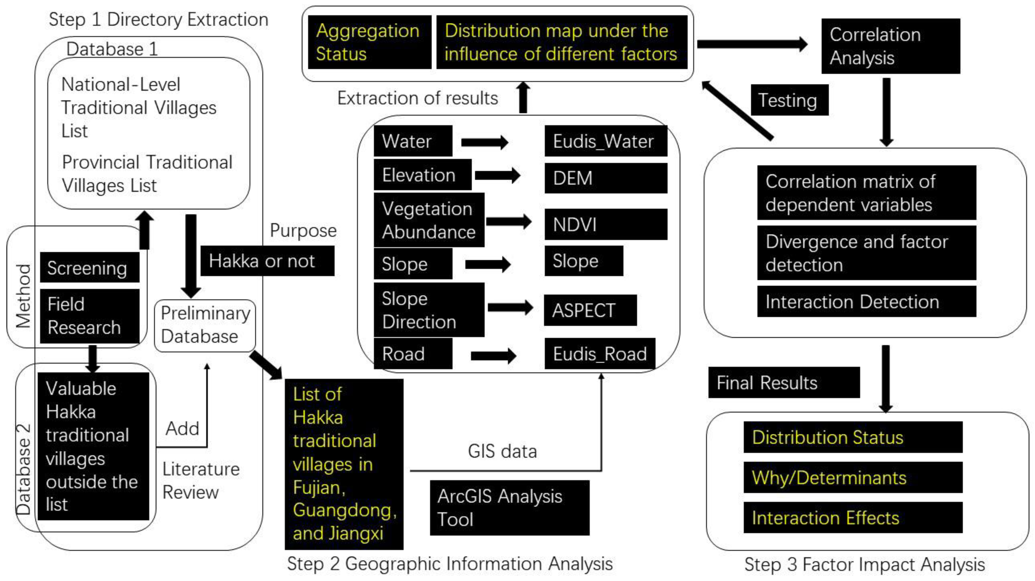
Figure 1. Technical roadmap for the study of spatial distribution characteristics and influencing factors of Hakka traditional villages in Fujian, Guangdong, and Jiangxi. NDVI: normalized difference vegetation index, DEM: digital elevation model, Slope: surface unit steepness data, ASPECT: data on the direction of projection of the normal to the slope on the horizontal plane, Eudis_Water: Euclidean distance between the village and the nearest water source, Eudis_Road: Euclidean distance between the village and the nearest road, GIS: Geographic information system database.
Sustainability 14 12068 g001
Figure 2. Location of the Study Area in China.
Sustainability 14 12068 g002
Figure 3. Kernel density analysis of Hakka traditional villages in Fujian, Guangdong, and Jiangxi.
Sustainability 14 12068 g003
Figure 4. Elevation analysis of Hakka traditional villages in Fujian, Guangdong, and Jiangxi. (a) Digital elevation model (DEM) < 200, (b) DEM 200–500, (c) DEM 500–1000, (d) DEM > 1000, and (e) kernel density elevation superimposed map.
Sustainability 14 12068 g004
Figure 5. Slope analysis of Hakka traditional villages in Fujian, Guangdong, and Jiangxi.
Sustainability 14 12068 g005
Figure 6. Slope direction analysis of Fujian–Guangdong–Jiangxi Hakka traditional villages.
Sustainability 14 12068 g006
Figure 7. Statistical analysis of the slopes of Hakka traditional villages in Fujian, Guangdong, and Jiangxi. (a) Percentage of the number of villages with different slopes; (b) percentage of village elevations with different slopes.
Sustainability 14 12068 g007
Figure 8. Graded superposition of the slope kernel densities of Hakka traditional villages in Fujian, Guangdong, and Jiangxi. (a) Flat slopes (0–5°); (b) gentle slopes (6–15°); (c) slopes (16–25°).
Sustainability 14 12068 g008
Figure 9. Overlaid slope-oriented kernel densities of Hakka traditional villages in Fujian, Guangdong, and Jiangxi. (a) Sun-facing slopes (90–270°); (b) shady slopes (0–90°, 270–360°).
Sustainability 14 12068 g009
Figure 10. Analysis of the buffer zone of Hakka traditional villages in Fujian, Guangdong, and Jiangxi. (a) Fujian–Guangdong–Jiangxi Hakka traditional road systems; and (b) Fujian–Guangdong–Jiangxi Hakka traditional water systems.
Sustainability 14 12068 g010
Figure 11. Superimposed map of the graded kernel density analysis of Fujian–Guangdong–Jiangxi Hakka traditional villages by land transport. Villages located within 1 km (a), between 1 and 5 km (b), and >5 km (c) from the main roads, respectively.
Sustainability 14 12068 g011
Figure 12. Superimposed map of water system classification kernel density analysis of Fujian–Guangdong–Jiangxi Hakka traditional villages. Villages within the 5 (a), 15 (b), and >15 (c) km buffer zone, respectively.
Sustainability 14 12068 g012
Figure 13. Normalized difference vegetation index (NDVI) analysis of Hakka traditional villages in Fujian, Guangdong, and Jiangxi.
Sustainability 14 12068 g013
Figure 14. Superimposed kernel density analysis of vegetation richness grading of Hakka traditional villages in Fujian, Guangdong, and Jiangxi. (a) Class I; (b) Class II; (c) Class III; (d) Class IV; and (e) Class V villages.
Sustainability 14 12068 g014
Figure 15. Correlation analysis matrix of dependent variables. Parameter names are the same as described in Figure 1. Aggregation: Village aggregation index. The blue dots show the scatter plot matrix, which reflects the values presented when the two factors interact. The scatter plot matrix allows for quick discovery of the main correlations of multiple variable interactions. The red curve is the fitted trend line, indicating the trend of the change in the single factor effect. ** indicates a highly significant difference (p < 0.01), and *** indicates an extremely significant difference (p < 0.001).
Sustainability 14 12068 g015
Table 1. Geographical detection table of influencing factors of spatial differentiation of Hakka traditional villages in Fujian, Guangdong, and Jiangxi. Parameter names are the same as described in Figure 1.
Eudis_WaterNDVIDEMEudis_RoadSlopeASPECT
q statistic0.1306940.0733160.113404090.0088359760.0084297620.003667296
p value0.0000.0000.0000.2712990.46184160.5276866
Table 2. Interaction detection of the influencing factors of Fujian–Guangdong–Jiangxi Hakka traditional villages.
Eudis_RoadNDVIDEMSlopeASPECTEudis_Water
Eudis_Road0.008836
NDVI0.0995350.073316
DEM0.1311470.1824530.113404
Slope0.0421880.0845770.1537530.00843
ASPECT0.0161070.0853040.1238520.0166420.003667
Eudis_Water0.1602980.1751330.1878780.1598080.1459390.130694
Parameter names are the same as described in Figure 1.
Table 3. Interaction detection results of the influencing factors of Fujian–Guangdong–Jiangxi Hakka traditional villages.
NumberDominant Interaction Factorq ValueInteraction Results
1Eudis_Road∩NDVI0.099535Non-linear enhancement
2Eudis_Road∩DEM0.131147Non-linear enhancement
3Eudis_Road∩Slope0.042188Non-linear enhancement
4Eudis_Road∩ASPECT0.016107Two-factor enhancement
5Eudis_Road∩Eudis_Water0.160298Non-linear enhancement
6NDVI∩DEM0.182453Two-factor enhancement
7NDVI∩Slope0.084577Two-factor enhancement
8NDVI∩ASPECT0.085304Non-linear enhancement
9NDVI∩Eudis_Water0.175133Two-factor enhancement
10DEM∩Slope0.153753Non-linear enhancement
11DEM∩ASPECT0.123852Non-linear enhancement
12DEM∩Eudis_Water0.187878Two-factor enhancement
13Slope∩ASPECT0.016642Two-factor enhancement
14Slope∩Eudis_Water0.159808Non-linear enhancement
15ASPECT∩Eudis_Water0.145939Non-linear enhancement
Parameter names are the same as described in Figure 1.
Publisher’s Note: MDPI stays neutral with regard to jurisdictional claims in published maps and institutional affiliations.