Review

Research Progress and Framework Construction of Urban Resilience Computational Simulation

1
Beijing Municipal Institute of City Planning & Design, Beijing 100045, China
2
School of Physical Science and Engineering, Beijing Jiaotong University, Beijing 100044, China
*
Author to whom correspondence should be addressed.
Sustainability 2022, 14(19), 11929; https://doi.org/10.3390/su141911929
Submission received: 24 August 2022 / Revised: 9 September 2022 / Accepted: 14 September 2022 / Published: 21 September 2022

Abstract

:
Simulating the dynamic process of urban resilience and analyzing the mechanism of resilience-influencing factors are of great significance to improve the intelligent decision-making ability of resilient urban planning. The purpose of this article is to implement a comprehensive literature review on the quantitative computation and simulation studies of urban resilience, investigating the characteristics of current research, including the most commonly applied methods, the most frequently space–time scales, the most popular research topics, and the most commonly involved risk types. Then, the study provides recommendations for future research: (1) research on multiple risk disturbance scenarios, (2) the computation of urban resilience from the public perspective, and (3) a computation-simulation framework with the goal of revealing the mechanism. Finally, this study constructs a resilience-computation simulation framework for resilient urban planning, which lays a foundation for the further development of urban-resilience dynamic-simulation computing and planning-scenario applications in the future.

1. Introduction

The modern urban system is facing increasing challenges due to climate change, natural disasters, pandemics, population growth, economic crises, and energy consumption. Improving urban resilience is a critical need for coping with uncertainty, reducing disaster risk, and promoting urban sustainable development [1]. With the proposal of 100 Resilient Cities, the Sustainable Development Goals (SDGs), and the New Urban Agenda, resilience has become a significant concept in urban planning, governance, and academic research [2,3]. “Resilience” comes from the field of engineering and originally meant “the ability of an object to return to its original state under the action of external forces.” In the 1970s, C. S. Holling introduced “resilience” into the ecology and proposed “ecological resilience,” which emphasizes alternative stable states [4]. Then, “resilience” gradually extended to the fields of economics, sociology, urban planning, and geography, with the connotation evolving from “engineering resilience (single balance)” to “ecological resilience (multiple balance)” and then to “social–ecological resilience (complex adaptive system)” [5,6,7,8]. Currently, existing literature focus on the conceptual framework of urban resilience [9], urban resilience-evaluation index systems [10], urban-resilience application and promotion strategies [5], urban-resilience quantitative simulation [11], urban-disaster risk reduction, urban sustainable development and resilience, and smart cities [12,13,14,15]. With the development of cities and the increase of complexity, there is a need for further research related to urban-resilience computation simulation adopting new methods and technologies.
As urban resilience is a multi-dimensional and dynamic phenomenon, building resilient cities is a dynamic and complex process. The internal mechanism of various resilience-influencing factors has not yet been captured [13,16]. How to scientifically simulate this complex, dynamic interaction process is the key procedure of urban-resilience research. Moreover, in the context of smart cities, the response speed of risk is crucial to urban resilience [2,17,18]. Real-time big-data technology can reduce the impact of disaster losses and improve the ability of urban rapid recovery [19,20]. Increasingly more studies have been concerned with the quantitative assessment, spatial visualization, and dynamic simulation of urban resilience. However, most studies quantitatively simulate resilience from a single perspective or a certain dimension, and are mostly conceptual rather than operational. The research on the multi-element dynamic-evolution process of urban resilience is still limited [6]. Therefore, future work should emphasize urban-resilience computation simulation leveraging an advanced “smart” approach (e.g., big data, urban computing, and artificial intelligence) to realize the transition from static mode to dynamic process and strengthen the ability of intelligent decision-making in cities [6,18,19].
Katarina [21] reviewed studies on quantitative resilience assessment of complex urban systems to natural disasters, emphasizing the impact of earthquakes. Melendez [11] focused on computational models from a community-resilience perspective, which was restricted to a micro scale. Compared with existing reviews, the purpose of this article is to provide a comprehensive review on the quantitative studies of urban resilience from multiple dimensions. From the methodological perspective, the study summarizes popular technologies used for the quantitative calculation and simulation of urban resilience and distinguishes quantitative approaches in terms of “soft” resilience and “hard” resilience. Based on the review, the authors proposed a novel resilience computation-simulation schema of urban planning. Furthermore, the research opportunities and challenges of resilience quantification leveraging intelligent methods are elaborated.
This paper is organized as follows. Section 2 provides concept explanation and research hierarchy of urban-resilience computation simulation. Section 3 is the literature review on urban-resilience quantitative simulation and computation. This section is divided into four subsections: “soft” resilience (Section 3.1), “hard” resilience (Section 3.2), comprehensive resilience (Section 3.3), and the summary (Section 3.4). Section 4 includes the architecture design and framework of urban-resilience computation simulation for resilient urban planning. Section 5 proposes concluding remarks and recommendations for future studies.

2. Definition of Urban-Resilience Computation Simulation

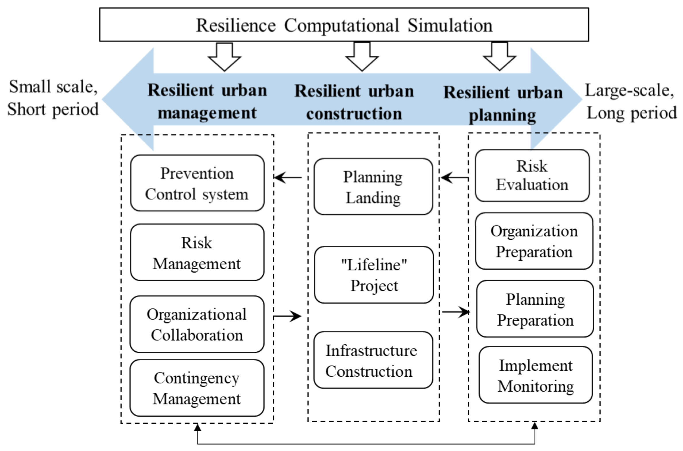
Urban resilience refers to the ability of an urban system to withstand, absorb, recover, and adapt to man-made or natural disturbances and to learn timely control of current and future expectations [22,23,24], as shown in Figure 1. With the rapid development of information and communications technologies (ICTs), the modern urban system is no longer a static materialized place, but a “complex system” that is made up of multidimensional components and dynamic interactions between economy, society, institution, ecology, and infrastructure [25,26]. In this context, urban resilience can also be understood as a series of complex solutions under complex uncertainty risks, including climate change, natural disasters, terrorist attacks, technical accidents, epidemics, and other risks [27]. By leveraging big data, artificial intelligence, the Internet of Things, and urban-computing technologies, urban-resilience computation simulation aims to quantitatively evaluate urban risk and vulnerability, assess urban-response ability and resilience under different scenarios, and investigate the nonlinearity and spatial heterogeneity of the resilience-recovery process, focusing especially on the complexity, dynamic adaptability, internal operation mechanism, and cause–effect chain of the urban system. It can not only provide decision-making solutions for resilient urban planning, construction, and management, but also provide strong support for urban response to emergencies and disaster scenarios (Figure 2).

3. Research Progress of Urban-Resilience Computation Simulation

Our criteria for filtering articles were (1) written in English or Chinese, (2) empirical studies or reviews about urban-resilience quantification, and (3) published in scientific journals, conferences, book chapters, or workshops, with the full text accessible. Web of Science, Scopus, Taylor & Francis, and China Journal Full-text Database (CJFD) were searched for articles from 2015 to 2022 in English and Chinese. The search terms included “urban resilience,” “city resilience,” “resilience,” “computing/computation/computational,” “quantify/quantification/quantitative,” “simulating/simulation,” “assess/assessment,” “measure/measuring,” “dynamic,” model/modeling,” and analysis/analyzing.” We obtained a final collection of 91 papers, including 26 in Chinese.

3.1. “Soft”-Resilience Computation Simulation

The “soft” resilience of cities includes socio-economic resilience and organizational resilience. Socio-economic resilience concentrates on urban economic diversity, employment level, economic-operation ability when risks occur, and the ability of different social groups to cope with risks [28,29]. Organizational resilience is referred to as the dynamic management, intervention, and adaptive capacity of government agencies, social organizations, and street communities in the event of disaster risks [30,31]. For “soft”-resilience computation simulation, the studies focused on resilience assessment, public behavior analysis, post-disaster simulation, and prediction by various methods, which could be categorized into three types: mathematical-statistics method, social big-data technology, and the dynamic-modeling method.

3.1.1. Mathematical-Statistics Method

Many scholars collected individual data by questionnaire surveys and interviews to construct a resilience-score or -rating system consisting of various indicators and used statistical methods to measure resilience. Forrest et al. [32] analyzed the social–spatial inequality of resilience in Anham City, the Netherlands, under flood risk by combining quantitative-resilience indicators with resident interviews. Nejat et al. [33] used the spatial-regression model to predict the probability of housing-reconstruction probability after Hurricane Sandy based on household data and identified the hotspots of housing reconstruction to assist post-disaster planning decisions. Heinzlef et al. [34] developed a spatial decision-support system based on a collaborative mechanism and a dependency curve to assist the decision-making of the organizational resilience of Quebec City in Canada under flood risk.

3.1.2. Social Big-Data Technology

Related research combined the social-media data, large-scale mobility data, point-of-interest (POI) data, and geographic-information data to evaluate the simulation of urban resilience from a bottom-up perspective [35,36,37,38,39]. Wang et al. [40] demonstrated a novel approach using the fusion of social-media data, land-use data, and other information to evaluate public response to flooding in Nanjing, China, supporting the formulation of urban flood-resilience policies. Hong et al. [41] utilized large-scale mobility data to measure community resilience and public-evacuation patterns of Harris County in the United States before, during, and after Hurricane Harvey to support resource-allocation decisions and long-term planning strategies. Chen et al. [42] integrated Baidu map location-based data, POI data, and population-density data to analyze urban human-flow disruptions in Shenzhen, China, during the 2018 Typhoon Mangkhut Ty and examine the impact of different urban functions on human flow. Sun et al. [43] fused a variety of data (e.g., ecological-environment data, urban-facilities data, and resident-mobility data) to evaluate urban haze-disaster resilience and its spatial characteristics from the perspective of residents using accessibility-analysis and network-analysis methods.

3.1.3. Dynamic-Modeling Method

Dynamic models such as the system-dynamics, game-theory, and agent-based models are also widely used in “soft”-resilience computation simulation [44]. Links et al. [45] proposed a system-dynamics computational model, COPEWELL, for predicting the recovery time of community function after an earthquake to quantify community resilience in the United States. Gao et al. [46] constructed an agent-based model to simulate the evacuation behavior of residents under different hurricane-warning levels and discovered that geo-targeted warnings can encourage individuals to make evacuation decisions. Grinberger et al. [47] combined a population-allocation algorithm with the a simulation platform to propose an agent-based model to simulate the welfare impacts of an earthquake in the central business district of Jerusalem on the economic resilience of people with different incomes.

3.2. “Hard”-Resilience Computation Simulation

“Hard” urban resilience consists of two dimensions: physical and natural. Physical resilience refers to the resilience of urban infrastructures [31,48], including urban pipelines, shelters and defense works, etc. Natural resilience includes ecological and environmental resilience [23,49]. “Hard” urban resilience is the key field of resilience-computation simulation. Many scholars have conducted extensive research on ecological-resilience evolution, risk-assessment and vulnerability analysis, and infrastructure-resilience simulation.

3.2.1. Ecological-Resilience Evolution

Taking climate change, urban morphology, environmental change, and ecological policy as objects of study, existing research mostly utilized numerical simulation, scenario simulation, landscape-index analysis, spatial analysis, and trend analysis of geostatistics to conduct ecological-resilience simulation [50]. Zhang et al. [51] leveraged the scenario-simulation method based on ordered weighted average (OWA) to quantitatively evaluate the social–ecological-landscape resilience of Mizhi county, China, from ecology, society, and production-system dimensions, and explored the spatiotemporal heterogeneity and evolution pattern. Using the numerical-simulation method, Peng et al. [52] simulated the physical-environment elements (e.g., wind speed, solar radiation, and noise) of the community and presented resilient-community planning-optimization strategies based on multi-objective simulation. Feng et al. [53] proposed a “scale-density-morphology” resilience model based on theories of landscape ecology to investigate the evolution characteristics of resilience in Shenyang, China; analyze the relationship between urban resilience with landscape elements quantitatively; and provide the adjusted strategy according to local conditions.

3.2.2. Risk-Assessment and Vulnerability Analysis

Probabilistic risk assessment, fragility curves, and empirical approaches were widely used to calculate the vulnerability of or risk to infrastructure under emergencies (e.g., earthquakes, floods, and hurricanes). The probability risk-assessment model (PRA) is a comprehensive process to estimate risk by quantifying the statistical uncertainty [54]. PRA has been used in an extensive array of studies of the risk of complex engineering systems in accident scenarios [55]. Fragility curves have been applied to the assessment of physical facility-structure damage after a disaster [56]. Dong et al. [56] combined the community’s physical vulnerability of interruption of access to critical facilities with the public’s tolerance of service interruption to analyze the spatial distribution of urban resilience in Harris County under flooding. Kammouh et al. [57] analyzed the recovery curves of urban lifelines (e.g., power, water, natural gas, and telecommunications) by using the data of 32 earthquakes and simulated their interaction mechanism. Moreover, empirical models [58], fuzzy logic [59], and probability models [60] are also applied to simulate the fragility curve of power lines in storm scenarios and predict and estimate the downtime of power and telecommunications systems after earthquakes.

3.2.3. Infrastructure-Resilience Simulation

The popular approaches preferred by most researchers for infrastructure-resilience simulation are complex networks, system-dynamics models, agent-based models, game theory, and probability dynamics [61,62,63,64]. For example, Nateghi et al. [65] leveraged a multivariate ensemble-tree-boosting algorithm to simultaneously predict the number of power outages, the number of users without power, and the cumulative time of power outage in the Central Gulf Coast Region of the U.S., impacted by Hurricane Katrina. Based on complex network and OpenStreetMap data, Yan et al. [66] built a measurement model to simulate the resilience level of urban-street networks in five global cities in two disturbance scenarios: random disturbance and sequence disturbance. Sun et al. [67] quantified the seismic capacity of the power-supply system based on the agent model. Marasco et al. [68] proposed a comprehensive data analysis and real-time computing platform integrating buildings, roads, water, electricity, and transportation networks to simulate the resilience of urban critical infrastructure in earthquakes.
Recently, the application of big data and deep-learning algorithms has also been broached by many scholars in urban-resilience computation simulation. For example, Kasmalkar et al. [69] simulated the regional-traffic pattern under flood by integrating multi-source data, and quantified the impact of flood-exposure, commuting-pattern, and road-network characteristics on traffic resilience. Wang al. [70] integrated a Diffusion Graph Convolution Recurrent Neutral Network and a transportation-resilience dynamic-capturing algorithm to evaluate and predict the spatial–temporal pattern of traffic resilience under extreme weather events based on DiDi Chuxing data and meteorological-grid data.

3.3. Comprehensive-Resilience Computation Simulation

Comprehensive urban-resilience simulation refers to the employment of several or all dimensions of urban system (e.g., socio-economic, organizational, physical, and natural) in computational simulation. Existing research focused on assessment, vulnerability assessment, and risk assessment for comprehensive urban resilience. The research methods involved statistics, geography, sociology, system dynamics, and other disciplines, which are mainly divided into mathematical statistics, spatial analysis, and dynamic modeling.

3.3.1. Mathematical-Statistics and Spatial-Analysis Methods

Relevant studies mainly involved principal component analysis, wavelet transform, trend analysis, variable analysis, structural-equation modeling (SEM), and the analytic hierarchy process (AHP) to quantize comprehensive urban resilience [71,72]. For example, Chen et al. [73] used the entropy-weighting TOPSIS method to analyze the spatial–temporal pattern and dynamic evolution of the comprehensive resilience in the Harbin-Changchun urban agglomeration in China from 2010 to 2018. Liu et al. [74] revealed the spatial–temporal pattern and evolution trend of social–ecological resilience of Shenyang Central City, China, in 1995 and 2015 by spatial analysis, landscape–pattern analysis, and spatial statistical analysis based on remote-sensing images. Chen et al. [75] constructed an urban-resilience evaluation-index system considering three attributes of resilience—resistance, recovery capability, and adaptive capacity—and utilized TOPSIS improved by the KL formula to evaluate Wuhan, China’s, urban resilience to rainstorm-flood disasters from 2009 to 2015. Wang et al. [48] evaluated the urban-flood resilience of Nanjing, China, from 1997 to 2017 by wavelet-transform and trend analysis, and systematically discussed the impact of social, economic, natural, physical, political, and institutional subsystems on the urban functional resilience. Li et al. [76] combined GIS and AHP to build a quantitative evaluation model for urban-waterlogging resilience and applied the model in Kunshan City, Jiangsu Province, China.

3.3.2. Dynamic-Modeling Method

The commonly used dynamic-modeling methods include complex networks, system dynamics, game theory, agent-based models, and scenario simulation [77,78,79,80]. For instance, Datola et al. [81] constructed the framework of a complex urban system from three aspects of environment, elements, and structure, leveraging complex adaptive-system theory (CAS). Li et al. [82] analyzed the causal-feedback and dynamic-interaction mechanism between urban-subsystem resilience using a system-dynamics model, and simulated the change process of Beijing’s comprehensive resilience by 2025. Chen et al. [83] proposed a new model for urban resilience considering adaptability, resistance, and recovery to simulate the resilience-change characteristics of Taiwan, China, during the Morakot. Maksims et al. [84] introduced a dynamic urban natural disaster-resilience assessment tool integrating system dynamics, a probabilistic approach, and a composite-indicator approach, and took the flood in Yergawa city, Latvia, as an example to realize urban-resilience assessment under different scenarios. Huang et al. [85] built an urban flood-resilience simulation model evolving the system-dynamics model and scenario simulation to investigate the dynamic changes of flood resilience of Nanjing, China, under four scenarios from 2009 to 2025. Li et al. [86] built a high-precision urban-rainstorm model in Huangpu District in Shanghai, China, based on numerical simulation and scenario simulation, and conducted flooding-risk simulation for different rainfall scenarios, providing resilience-improvement strategies for flood disasters. RuiBa et al. [87] proposed a multi-disaster analysis method integrating experiments and simulations, multi-hazard field investigation, and scenario analysis and response, taking the T3 terminal of Urumqi Diwopu International Airport in China under the coupling of wind, snow, and multi-disaster as the research object.

3.4. Summary

Based on the progress presented above, this study systematically interpreted the current research situation in regard to the resilience dimension, disturbance type, spatial–temporal scale, data indicators, and application methods of quantitative research on urban resilience (Table 1).
The space–time scale of computational simulation in the review articles varied with the resilience dimension. Most studies quantified urban resilience at a single scale, whereas only a few studies involved multi-scale resilience-computation simulation. For example, the ecological, economic, and comprehensive resilience were measured in country-level, region-level, and city-level scales within long-time series. Studies of social resilience and infrastructure resilience revolved around a certain disaster event, analyzing the characteristics of short time series at the city level and community level. This situation reveals the lack of understanding of resilience quantification at multiple scales. As urban resilience has great impacts on individuals, cities, and countries, it is essential to integration on multiple scales.
In the reviewed literature, most of the studies’ typological contexts were resilience simulation, risk assessment, and vulnerability analysis of a single disaster, such as floods, earthquakes, hurricanes, and typhoons. Some studies focused on the impact of climate change, urban growth, and natural-environment change. Only a few studies included multi-disaster coupling, multi-risk scenarios, and the coupling mechanism between multiple subsystems in cities [82,87].
For data and indicators, most of the reviewed studies employed traditional statistical data combining questionnaires and expert scoring methods to quantify resilience. Calculating resilience indicators through professional models based on remote-sensing, geographic, and monitoring data was also common. On the other hand, there was an increasing tendency to utilize multi-source-sensing data to calculate resilience indicators.
With respect to the commonly used methods in resilience simulation, mathematical-statistics, spatial-analysis, and dynamic-modeling methods were most popular in the reviewed studies. A few scholars also incorporated the use of semantic analysis, sentiment analysis, and convolutional neural networks (CNNs) based on Internet big data. Since disaster directly affects urban public life, it may be very necessary to implement resilience simulation combining information on people’s opinions, which was neglected in the existing research.
The research on urban-resilience simulation has developed rapidly, becoming a research hotspot in the fields of geography, disaster science, urban planning, and ecology. It has accumulated rich research achievements and laid a solid theoretical, data, and methodological foundation. However, there are also some research gaps in the current literature:
(1)
Multiple-risk disturbance scenarios are a potential area for improvement in resilience-computation simulation. Urban resilience should not only focus on the impact of single natural or man-made disasters, but also consider the coupling effect between various risk disturbances [88]. Existing studies mostly concerned single disturbance (e.g., flood, earthquake, and typhoon). More computational simulation should consider the multiple-hazard disaster scenario. In addition to exploring the evolutionary dynamic mechanism of resilience under various risks, future research should also simulate the dynamic interaction between multi-risks and the influencing mechanism of multi-risk on urban resilience.
(2)
There is a growing need for computational simulation of urban resilience based on human-centric information. Leveraging large-scale emerging data such as mobile phone-location data, social-media data, and public travel data, individual behaviors can be ”quantified” as group wisdom by mining people’s response patterns (e.g., the spatial–temporal pattern, semantic topics, and travel change) under a risk event [89]. These findings can provide new insights for the analysis, evaluation, decision-making, and planning management of urban resilience. In order to characterize, evaluate, and predict urban resilience, existing studies mostly used statistical models to mine public behavior patterns to certain disaster events in a short time from one dimension (e.g., temporal, spatial, or semantic). In the future, urban computing and data-driven methods can be combined to strengthen the innovative research of urban-resilience computation simulation from the perspective of multiple disturbances, long time series, and multiple dimensions.
(3)
The research on the urban-resilience computation-simulation framework with the goal of revealing the mechanism is still insufficient. The existing resilience framework still revolves around resilience-characteristics analysis, resilience assessment, and simulation of resilience evolution under various scenarios, orienting to a single dimension (e.g., ecology, society, or infrastructure). There is a lack of systematic research on the resilience-function mechanism, effect mechanism, and dynamic developing process. Future studies should consider the combination of artificial intelligence, urban computing, complex systems, and spatial-visualization technologies to establish an urban-resilience computation-simulation framework that can reveal the complex relationship between urban resilience and urban structural elements, and explore a multi-level, multi perspective, and multi-dimensional dynamic urban-resilience mechanism.

4. Computation-Simulation Framework for Resilient Urban Planning

4.1. Architecture Design

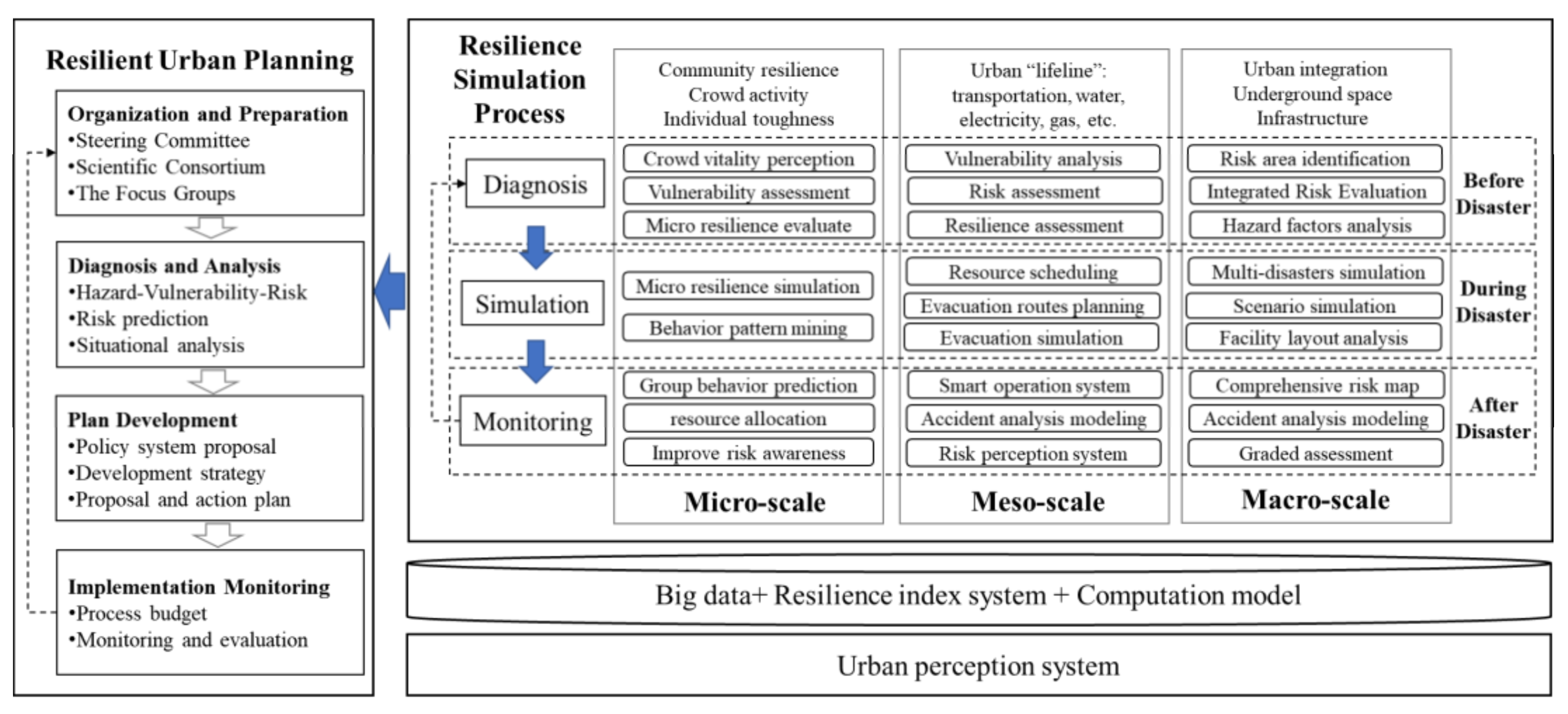
Since urban systems are complex, it is necessary to fully understand the composition and interaction mechanism of urban resilience and consider the coupling relationship between different elements and the overall dynamic mechanism in the process of computational simulation of urban resilience. In resilient urban planning, the Earthquake Emergency Initiative (EMI) released the Urban Resilience Master Planning (URMP) for developing countries in 2015. The URMP proposes a resilient urban-planning process called “Organization and Preparation—Diagnosis and Analysis—Plan Development—Plan Implementation, Monitoring and Evaluation“ [90]. Based on the process, the resilience computation simulation can assist with resilient urban planning from three scales—“micro–meso–macro”—to realize resilience computation simulation of the whole process of “diagnosis–simulation–deduction” with the resilience-index system, urban perception, artificial intelligence, big-data technology, and urban computer technologies, coupled with municipal, health, and environmental protection, as well as other urban subsystems (Figure 3).

4.2. Computation-Simulation Framework

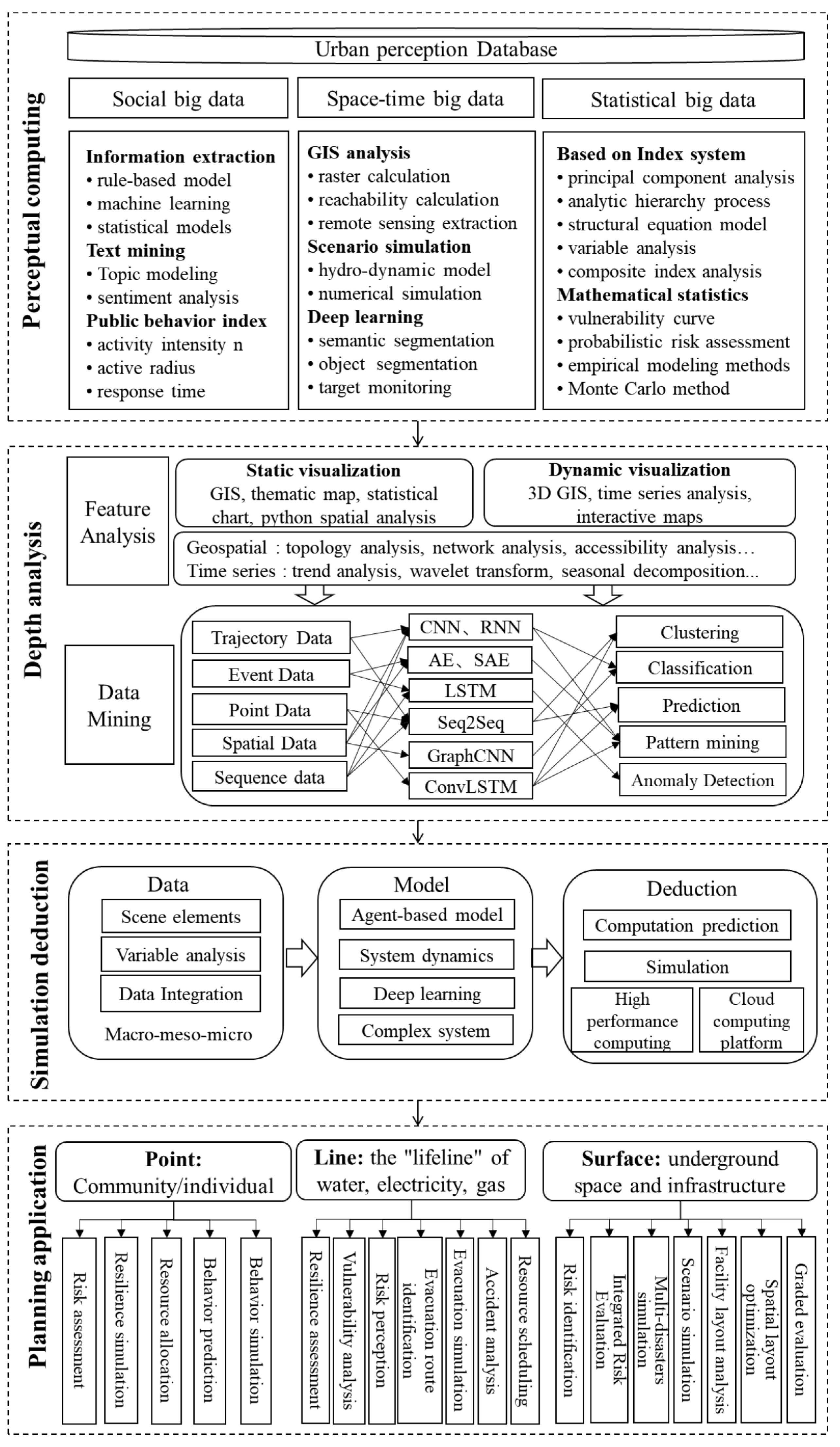
Based on the existing research progress, this paper proposes a computation-simulation framework of urban resilience for resilient urban planning (Figure 4), fusing technical methods of perception, computation, cognition, and deduction, that is divided into four stages: perceptual computing, depth analysis, simulation deduction, and planning application.
Perceptual computing is the basis of resilience-computation simulation and the front end of resilient urban planning. Based on the perceptual database highly integrating urban physical–social-sensing systems, perceptual computing utilizes information extraction, text mining, public behavior quantification, and a resilience-index system to process and extract the original data, and then combines mathematical statistics, GIS spatial analysis, deep learning, scene simulation, and other methods to build a resilience-computing model, which obtains and calculates the feature elements of resilience from urban social big data, spatial–temporal big data, and statistical big data, providing a basis for subsequent in-depth analysis and evaluation.
Depth analysis is a process of describing and analyzing cities based on various computing models [24], mainly including feature analysis and data mining. Feature analysis processes the results of perceptual computing to realize the visual display, spatial-feature analysis, and time-series analysis of resilience-feature elements. Data mining converts original data into deep-learning-data format, and then deep-learning algorithms (e.g., convolutional neural networks, graph convolutional networks, or recurrent neural networks) are used to process various data-mining tasks, such as prediction, classification, pattern mining, anomaly monitoring, etc.
Simulation deduction concentrates on the mechanism interpretation and prediction feedback of urban resilience. First, the relationship among resilience objects, states, events, and processes is analyzed at macro–meso–micro scales [91]. Scene-feature extraction, variable analysis, rule construction, and data integration are completed. Then, the simulation and deduction model of the urban-resilience spatio–temporal process under different scenarios is built based on a system-dynamics model, agent-based modeling (ABM), deep learning, and complex networks. The computation, prediction, and simulation of the urban-resilience process are realized by combining them with a high-performance computing platform.
The application scenarios of the framework in resilient urban planning can be described as three scales: point, line, and surface. The “point” level is from the perspective of the community and the public, such as the community’s risk-perception assessment, resilience simulation, and resource-allocation optimization, as well as public-behavior simulation and group-behavior prediction. The “line” level involves the urban “lifeline” (e.g., traffic, water, point, and gas), in which the framework can be used for resilience assessment, vulnerability analysis, risk-perception identification, evacuation-channel identification, emergency-evacuation simulation, and real-time resource scheduling. The “surface” scale mainly refers to the infrastructure and the whole level of the city, including application scenarios such as risk-area identification, comprehensive risk assessment, multi-disaster-coupling simulation, scenario-simulation prediction, facility-layout optimization, and hierarchical-assessment warning.

5. Conclusions

This paper systematically reviews the research progress of urban-resilience computation simulation from the perspectives of social–economic resilience, ecological-environment resilience, infrastructure resilience, and comprehensive resilience, including resilience dimensions, disturbance type, space–time scale, resilience indicators, data, and methods. In the reviewed literature, most of the research utilized mathematical statistics, spatial analysis, and dynamic-modeling optimization to realize risk assessment, resilience-computation evaluation, and resilience-simulation prediction based on the traditional statistical data, geographic data, and multi-source-sensing data around certain disaster events (e.g., floods, earthquakes, hurricanes, and typhoons) at a single scale (e.g., city level, country level, and community level). This work is not confined to a simple review of existing studies and has the potential to provide assistance for future studies in the domain of urban-resilience computation simulation. Specifically, this study indicates that (1) the multi-scale resilience-computation simulation under multiple-disaster scenarios is relatively rare in the existing research. It might hold potential for future research to overcome the problem of multi-scene coupling and analyze more scales. (2) Resilience simulation integrating human-centric information is far from mature. Resilience simulation integrating human-activity data and traditional data is an important part of future work. (3) The existing research emphasizes the revelation of patterns and the description of phenomena, ignoring the analysis of resilience-function mechanisms, influence mechanisms, and dynamic developing processes. With the current research progress, the paper explores and proposes a computation-simulation method and application-scenario framework for resilient urban planning. This framework expounds the key methodological issues systematically involved in resilience-computation simulation from perceptual computing, depth analysis, and simulation-deduction aspects. It also focuses on the application scenarios of resilient urban planning and provides a theoretical and methodological basis for resilience research in urban planning.
Despite efforts to ensure rigorous analysis, this study still has some limitations. First, we focus on the social–economic, ecological, infrastructure, and comprehensive dimensions of urban resilience, and there are more detailed dimensions that may have been ignored. Second, the reviewed papers are limited to academic literature in the selected databases. There are many unpublished or published studies that have not been retrieved that are also useful. Third, the further determination of the viewpoints proposed in this paper needs to be tested in practice. Future studies should put emphasis on the evolution mechanism of urban resilience under multiple disasters, the resilience-perception computation of public participation, the simulation-deduction framework of urban resilience, and its scenario application in urban planning to assist and support scientific decision-making in the planning, management, and construction of resilient cities.

Author Contributions

Conceptualization, X.Z. (Xiaodong Zhang) and H.W.; methodology, X.H.; formal analysis, X.H., L.W. and D.X.; investigation, X.H., L.W. and D.X.; writing—original draft preparation, X.H.; writing—review and editing, X.Z. (Xiaodong Zhang) and X.Z. (Xinghua Zhang). All authors have read and agreed to the published version of the manuscript.

Funding

This research is supported by the National Key R&D Program of China (Nos. 2021YFA1000300 and 2021YFA1000304) and the Beijing Science and Technology Plan (No. Z211100004121014).

Institutional Review Board Statement

Not applicable.

Informed Consent Statement

Not applicable.

Data Availability Statement

Not applicable.

Conflicts of Interest

The authors declare no conflict of interest.

References

  1. Ernstson, H.; van der Leeuw, S.E.; Redman, C.L.; Meffert, D.J.; Davis, G.; Alfsen, C.; Elmqvist, T. Urban transitions: On urban resilience and human-dominated ecosystems. Ambio 2010, 39, 531–545. [Google Scholar] [CrossRef]
  2. Meerow, S.; Newell, J.P.; Stults, M. Defining urban resilience: A review. Landsc. Urban Plan. 2016, 147, 38–49. [Google Scholar] [CrossRef]
  3. Zhai, G.; Xia, C. Strategic Emphasis on the Construction of Resilient Cities in China. City Plan. Rev. 2021, 45, 44–48. (In Chinese) [Google Scholar]
  4. Holling, C.S. Resilience and Stability of Ecological Systems. Annu. Rev. Ecol. Syst. 1973, 4, 1–23. [Google Scholar] [CrossRef]
  5. Masnavi, M.R.; Gharai, F.; Hajibandeh, M. Exploring urban resilience thinking for its application in urban planning: A review of literature. Int. J. Environ. Sci. Technol. 2018, 16, 567–582. [Google Scholar] [CrossRef]
  6. Zhao, R.; Fang, C.; Liu, H. Progress and prospect of urban resilience research. Prog. Geogr. 2020, 39, 1717–1731. (In Chinese) [Google Scholar] [CrossRef]
  7. Yang, X.-P.; Wang, L.-K.; Li, Y.-B. Review and Prospects of Resilient City Theory. Geogr. Geoinf. Sci. 2021, 37, 78–84. (In Chinese) [Google Scholar]
  8. Wei, Y.; Xiu, C. Study on the concept and analytical framework of city network resilience. Prog. Geogr. 2020, 39, 488–502. (In Chinese) [Google Scholar] [CrossRef]
  9. Woodruff, S.; Bowman, A.; Hannibal, B.; Sansom, G.; Portney, K. Urban resilience: Analyzing the policies of U.S. cities. Cities 2021, 115, 103239. [Google Scholar] [CrossRef]
  10. Xiu, C.; Mei, D.; Bai, L.; Feng, X.; Wei, Y. A comprehensive assessment of urban resilience and its spatial differentiation in China. World Reg. Stud. 2019, 28, 77–87. (In Chinese) [Google Scholar]
  11. Melendez, A.; Caballero-Russi, D.; Gutierrez Soto, M.; Giraldo, L.F. Computational models of community resilience. Nat. Hazards 2021, 111, 1121–1151. [Google Scholar] [CrossRef]
  12. Tongyue, L. New Progress in Study on Resilient Cities. Urban Plan. Int. 2017, 32, 15–25. (In Chinese) [Google Scholar]
  13. Zang, X.; Wang, Q. The evolution of the urban resilience concept, and its research contents and development trend. Sci. Technol. Rev. 2019, 37, 94–104. (In Chinese) [Google Scholar]
  14. Bansal, N.; Mukherjee, M.; Gairola, A. Smart Cities and Disaster Resilience. In From Poverty, Inequality to Smart City; Springer: Singapore, 2017; pp. 109–122. [Google Scholar]
  15. Oke, A.E.; Aghimien, D.O.; Akinradewo, O.I.; Aigbavboa, C.O. Improving resilience of cities through smart city drivers. Constr. Econ. Build. 2020, 20, 45–64. [Google Scholar] [CrossRef]
  16. Sharifi, A. Urban form resilience: A meso-scale analysis. Cities 2019, 93, 238–252. [Google Scholar] [CrossRef]
  17. Palmieri, F.; Ficco, M.; Pardi, S.; Castiglione, A. A cloud-based architecture for emergency management and first responders localization in smart city environments. Comput. Electr. Eng. 2016, 56, 810–830. [Google Scholar] [CrossRef]
  18. Yao, F.; Wang, Y. Towards resilient and smart cities: A real-time urban analytical and geo-visual system for social media streaming data. Sustain. Cities Soc. 2020, 63, 102448. [Google Scholar] [CrossRef]
  19. DesRoches, R.; Taylor, J. The promise of smart and resilient cities. Bridge 2018, 48, 2. [Google Scholar]
  20. Kontokosta, C.E.; Malik, A. The Resilience to Emergencies and Disasters Index: Applying big data to benchmark and validate neighborhood resilience capacity. Sustain. Cities Soc. 2018, 36, 272–285. [Google Scholar] [CrossRef]
  21. Rus, K.; Kilar, V.; Koren, D. Resilience assessment of complex urban systems to natural disasters: A new literature review. Int. J. Disaster Risk Reduct. 2018, 31, 311–330. [Google Scholar] [CrossRef]
  22. Chen, Z.; Qiu, B.; Chen, H. Research on Resiliency Level Promotion and Robustness Strategy of Resilient City System: From Complex Adaptive Systems (CAS) Perspective. Urban Dev. Stud. 2021, 28, 1–9. (In Chinese) [Google Scholar]
  23. Ribeiro, P.J.G.; Pena Jardim Gonçalves, L.A. Urban resilience: A conceptual framework. Sustain. Cities Soc. 2019, 50, 101625. [Google Scholar] [CrossRef]
  24. Baoxing, Q. Methods and Principles of Designing Resilient City Based on Complex Adaptive System Theory. Urban Dev. Stud. 2018, 25, 1–3. (In Chinese) [Google Scholar]
  25. Zhang, X.X.D.; Wang, L. Model Architecture and Urban Computing for Parallel Cities Based on Complex Adaptive Systems. J. Command. Control. 2021, 7, 28–37. (In Chinese) [Google Scholar]
  26. Liu, Y. Urban Resilience System Development Measurement: Based on an Empirical Study of 288 Chinese Cities. Urban Dev. Stud. 2021, 28, 93–100. [Google Scholar]
  27. Coaffee, J.; Therrien, M.C.; Chelleri, L.; Henstra, D.; Aldrich, D.P.; Mitchell, C.L.; Tsenkova, S.; Rigaud, É. Urban resilience implementation: A policy challenge and research agenda for the 21st century. J. Contingencies Crisis Manag. 2018, 26, 403–410. [Google Scholar] [CrossRef]
  28. Moghadas, M.; Asadzadeh, A.; Vafeidis, A.; Fekete, A.; Kötter, T. A multi-criteria approach for assessing urban flood resilience in Tehran, Iran. Int. J. Disaster Risk Reduct. 2019, 35, 101069. [Google Scholar] [CrossRef]
  29. Scherzer, S.; Lujala, P.; Rød, J.K. A community resilience index for Norway: An adaptation of the Baseline Resilience Indicators for Communities (BRIC). Int. J. Disaster Risk Reduct. 2019, 36, 101107. [Google Scholar] [CrossRef]
  30. Eakin, H.; Bojórquez-Tapia, L.A.; Janssen, M.A.; Georgescu, M.; Manuel-Navarrete, D.; Vivoni, E.R.; Escalante, A.E.; Baeza-Castro, A.; Mazari-Hiriart, M.; Lerner, A.M. Opinion: Urban resilience efforts must consider social and political forces. Proc. Natl. Acad. Sci. USA 2017, 114, 186–189. [Google Scholar] [CrossRef]
  31. Lyu, Y.-F.; Xiang, M.-T.; Wang, M.-J.; Wu, C.-F. From disaster prevention to resilience construction: Exploration and prospect of resilience planning under the back-ground of territorial governance. J. Nat. Resour. 2021, 36, 2281–2293. (In Chinese) [Google Scholar] [CrossRef]
  32. Forrest, S.A.; Trell, E.-M.; Woltjer, J. Socio-spatial inequalities in flood resilience: Rainfall flooding in the city of Arnhem. Cities 2020, 105, 102843. [Google Scholar] [CrossRef]
  33. Nejat, A.; Javid, R.J.; Ghosh, S.; Moradi, S. A spatially explicit model of postdisaster housing recovery. Comput. Aided Civ. Infrastruct. Eng. 2019, 35, 150–161. [Google Scholar] [CrossRef]
  34. Heinzlef, C.; Robert, B.; Hémond, Y.; Serre, D. Operating urban resilience strategies to face climate change and associated risks: Some advances from theory to application in Canada and France. Cities 2020, 104, 102762. [Google Scholar] [CrossRef]
  35. Podesta, C.; Coleman, N.; Esmalian, A.; Yuan, F.; Mostafavi, A. Quantifying community resilience based on fluctuations in visits to points-of-interest derived from digital trace data. J. R Soc. Interface 2021, 18, 20210158. [Google Scholar] [CrossRef]
  36. Zhang, C.; Yao, W.; Yang, Y.; Huang, R.; Mostafavi, A. Semiautomated social media analytics for sensing societal impacts due to community disruptions during disasters. Comput. Aided Civ. Infrastruct. Eng. 2020, 35, 1331–1348. [Google Scholar] [CrossRef]
  37. Li, Q.; Tang, Z.; Coleman, N.; Mostafavi, A. Detecting early-warning signals in time series of visits to points of interest to examine population response to COVID-19 pandemic. IEEE Access 2021, 9, 27189–27200. [Google Scholar] [CrossRef]
  38. Laun, A.W. Data Architecture to Quantify and Characterize the Resilience of a Natural Disaster-Affected System. Doctoral dissertation, The George Washington University, Washington, DC, USA, 2022. [Google Scholar]
  39. Kryvasheyeu, Y.; Chen, H.; Obradovich, N.; Moro, E.; Van Hentenryck, P.; Fowler, J.; Cebrian, M. Rapid assessment of disaster damage using social media activity. Sci. Adv. 2016, 2, e1500779. [Google Scholar] [CrossRef]
  40. Wang, B.; Loo, B.P.Y.; Zhen, F.; Xi, G. Urban resilience from the lens of social media data: Responses to urban flooding in Nanjing, China. Cities 2020, 106, 102884. [Google Scholar] [CrossRef]
  41. Hong, B.; Bonczak, B.J.; Gupta, A.; Kontokosta, C.E. Measuring inequality in community resilience to natural disasters using large-scale mobility data. Nat. Commun. 2021, 12, 1870. [Google Scholar] [CrossRef]
  42. Chen, Z.; Gong, Z.; Yang, S.; Ma, Q.; Kan, C. Impact of extreme weather events on urban human flow: A perspective from location-based service data. Comput. Env. Urban Syst. 2020, 83, 101520. [Google Scholar] [CrossRef]
  43. Honghu, S. Evaluation of Urban Haze Disaster Resilience from the Perspective of Residents’ Activity: A Case Study of the Main Urban Area of Nanjing City. Sci. Geogr. Sin. 2019, 39, 788–796. (In Chinese) [Google Scholar]
  44. Taberna, A.; Filatova, T.; Roy, D.; Noll, B. Tracing resilience, social dynamics and behavioral change: A review of agent-based flood risk models. Socio-Environ. Syst. Model. 2020, 2, 17938. [Google Scholar] [CrossRef]
  45. Links, J.M.; Schwartz, B.S.; Lin, S.; Kanarek, N.; Mitrani-Reiser, J.; Sell, T.K.; Watson, C.R.; Ward, D.; Slemp, C.; Burhans, R. COPEWELL: A conceptual framework and system dynamics model for predicting community functioning and resilience after disasters. Disaster Med. Public Health Prep. 2018, 12, 127–137. [Google Scholar] [CrossRef]
  46. Gao, S.; Wang, Y. Assessing the impact of geo-targeted warning messages on residents’ evacuation decisions before a hurricane using agent-based modeling. Nat. Hazards 2021, 107, 123–146. [Google Scholar] [CrossRef]
  47. Grinberger, A.Y.; Felsenstein, D. Dynamic agent based simulation of welfare effects of urban disasters. Comput. Environ. Urban Syst. 2016, 59, 129–141. [Google Scholar] [CrossRef]
  48. Wang, P.; Li, Y.; Zhang, Y. An urban system perspective on urban flood resilience using SEM: Evidence from Nanjing city, China. Nat. Hazards 2021, 109, 2575–2599. [Google Scholar] [CrossRef]
  49. Xu, Y.; Li, G.; Cui, S. Review and Perspective on Resilience Science: From Ecological Theory to Urban Practice. Acta Ecol. Sin. 2018, 38, 5297–5304. (In Chinese) [Google Scholar]
  50. Hou, C.; Zhou, L.; Wen, Y. Evaluation of social-ecological systems resilience in ecological policy: A case study in Yanchi, Ningxia, China. China Popul. Resour. Environ. 2018, 28, 117–126. (In Chinese) [Google Scholar]
  51. Zhang, H.; Lliang, X.; Liu, D.; Shi, Q.; Hai, C. The resilience evolution and scenario simulation of social-ecological landscape in the fragile area. Acta Geogr. Sin. 2019, 74, 1450–1466. (In Chinese) [Google Scholar]
  52. Peng, L.; Xu, S.; Li, Z. Research on resilience improvement of urban communities based on multi-objective simulation. In Proceedings of the 2020 China Urban Planning Annual Conference, Chengdu, China, 25 September 2021; pp. 214–222. [Google Scholar]
  53. Feng, X.; Xiu, C.; Bai, L.; Zhong, Y.; Wei, Y. Comprehensive evaluation of urban resilience based on the perspective of landscape pattern: A case study of Shenyang city. Cities 2020, 104, 102722. [Google Scholar] [CrossRef]
  54. Salgado-Gálvez, M.A.; Zuloaga Romero, D.; Velásquez, C.A.; Carreño, M.L.; Cardona, O.-D.; Barbat, A.H. Urban seismic risk index for Medellín, Colombia, based on probabilistic loss and casualties estimations. Nat. Hazards 2016, 80, 1995–2021. [Google Scholar] [CrossRef]
  55. Bozza, A.; Asprone, D.; Parisi, F.; Manfredi, G. Alternative resilience indices for city ecosystems subjected to natural hazards. Comput. Aided Civ. Infrastruct. Eng. 2017, 32, 527–545. [Google Scholar] [CrossRef]
  56. Dong, S.; Esmalian, A.; Farahmand, H.; Mostafavi, A. An integrated physical-social analysis of disrupted access to critical facilities and community service-loss tolerance in urban flooding. Comput. Environ. Urban Syst. 2020, 80, 101443. [Google Scholar] [CrossRef]
  57. Kammouh, O.; Cimellaro, G.P.; Mahin, S.A. Downtime estimation and analysis of lifelines after an earthquake. Eng. Struct. 2018, 173, 393–403. [Google Scholar] [CrossRef]
  58. Dunn, S.; Wilkinson, S.; Alderson, D.; Fowler, H.; Galasso, C. Fragility curves for assessing the resilience of electricity networks constructed from an extensive fault database. Nat. Hazards Rev. 2018, 19, 04017019. [Google Scholar] [CrossRef]
  59. De Iuliis, M.; Kammouh, O.; Cimellaro, G.P.; Tesfamariam, S. Downtime estimation of building structures using fuzzy logic. Int. J. Disaster Risk Reduct. 2019, 34, 196–208. [Google Scholar] [CrossRef]
  60. De Iuliis, M.; Kammouh, O.; Cimellaro, G.P.; Tesfamariam, S. Quantifying restoration time of power and telecommunication lifelines after earthquakes using Bayesian belief network model. Reliab. Eng. Syst. Saf. 2021, 208, 107320. [Google Scholar] [CrossRef]
  61. Huang, W.; Ling, M. System resilience assessment method of urban lifeline system for GIS. Comput. Environ. Urban Syst. 2018, 71, 67–80. [Google Scholar] [CrossRef]
  62. Burger, A.; Oz, T.; Kennedy, W.G.; Crooks, A.T. Computational Social Science of Disasters: Opportunities and Challenges. Future Internet 2019, 11, 103. [Google Scholar] [CrossRef]
  63. Dresback, K.M.; Szpilka, C.M.; Xue, X.; Vergara, H.; Wang, N.; Kolar, R.L.; Xu, J.; Geoghegan, K.M. Steps towards Modeling Community Resilience under Climate Change: Hazard Model Development. J. Mar. Sci. Eng. 2019, 7, 225. [Google Scholar] [CrossRef]
  64. Ferdowsi, A.; Sanjab, A.; Saad, W.; Mandayam, N.B. Game Theory for Secure Critical Interdependent Gas-Power-Water Infrastructure; 2017 Resilience Week (RWS), 2017; IEEE: Piscataway, NJ, USA, 2017; pp. 184–190. [Google Scholar]
  65. Nateghi, R. Multi-dimensional infrastructure resilience modeling: An application to hurricane-prone electric power distribution systems. IEEE Access 2018, 6, 13478–13489. [Google Scholar] [CrossRef]
  66. Yan, W.; Lu, J.; Li, Z.; Shen, Y. Implications of Measuring Resilience of Urban Street Networks: Comparative Study of Five Global Cities. Urban Plan. Int. 2021, 36, 1–12+137. (In Chinese) [Google Scholar]
  67. Sun, L.; Stojadinovic, B.; Sansavini, G. Agent-Based Recovery Model for Seismic Resilience Evaluation of Electrified Communities. Risk Anal. 2019, 39, 1597–1614. [Google Scholar] [CrossRef]
  68. Marasco, S.; Cardoni, A.; Noori, A.Z.; Kammouh, O.; Domaneschi, M.; Cimellaro, G.P. Integrated platform to assess seismic resilience at the community level. Sustain. Cities Soc. 2021, 64, 102506. [Google Scholar] [CrossRef]
  69. Kasmalkar, I.G.; Serafin, K.A.; Miao, Y.; Bick, I.A.; Ortolano, L.; Ouyang, D.; Suckale, J. When floods hit the road: Resilience to flood-related traffic disruption in the San Francisco Bay Area and beyond. Sci. Adv. 2020, 6, eaba2423. [Google Scholar] [CrossRef]
  70. Wang, H.-W.; Peng, Z.-R.; Wang, D.; Meng, Y.; Wu, T.; Sun, W.; Lu, Q.-C. Evaluation and prediction of transportation resilience under extreme weather events: A diffusion graph convolutional approach. Transp. Res. Part C Emerg. Technol. 2020, 115, 102619. [Google Scholar] [CrossRef]
  71. Zhang, P.; Yu, W.; Zhang, T. Spatial-temporal differentiation and its influencing factors of Shandong Province’s urban resilience. Urban Probl. 2018, 9, 27–34. (In Chinese) [Google Scholar]
  72. Lu, L.; Zhou, H.; Xu, Q. Application research on comprehensive evaluation of urban resilience from the perspective of multidimensional relational networks. Urban Probl. 2020, 8, 42–55. (In Chinese) [Google Scholar]
  73. Chen, X.; Lou, J.; Wang, Y. Evolution and Dynamic Simulation of the Temporal-Spatial Pattern of Urban Resilience in Harbin-Changchun Urban Group. Sci. Geogr. Sin. 2020, 40, 2000–2009. (In Chinese) [Google Scholar]
  74. Liu, Z. Exploring Urban Resilience from a Social-EcologicalPerspective: A Case Study of the Central City of Shenyang. Ph.D. Dissertation, Northeast Normal University, Changchun, China, 2019. (In Chinese). [Google Scholar]
  75. Chen, C.; Chen, Y.; Shi, B.; Tong, X. A model for evaluating urban resilience to rainstorm flood disasters. China Saf. Sci. J. 2018, 28, 1–6. (In Chinese) [Google Scholar]
  76. Zhengzhao, L.I.; Dafang, F.U.; Junxian, W.A.; Kedong, M.I.; Junyu, Z.H. Urban resilience assessment model for waterlogging disasters and its applica-tion. J. Tsinghua Univ. 2022, 62, 266–276. (In Chinese) [Google Scholar]
  77. Shao, W.; Su, X.; Lu, J.; Liu, J.; Yang, Z.; Mei, C.; Liu, C.; Lu, J. Urban Resilience of Shenzhen City under Climate Change. Atmosphere 2021, 12, 537. [Google Scholar] [CrossRef]
  78. Gao, J.; Barzel, B.; Barabasi, A.L. Universal resilience patterns in complex networks. Nature 2016, 530, 307–312. [Google Scholar] [CrossRef]
  79. Roy, D.; Lees, M. Understanding resilience in slums using an agent-based model. Comput. Environ. Urban Syst. 2020, 80, 101458. [Google Scholar] [CrossRef]
  80. Shi, Y.; Zhai, G.; Zhou, S.; Lu, Y.; Chen, W.; Deng, J. How Can Cities Respond to Flood Disaster Risks under Multi-Scenario Simulation? A Case Study of Xiamen, China. Int. J. Environ. Res. Public Health 2019, 16, 618. [Google Scholar] [CrossRef]
  81. Datola, G.; Bottero, M.; De Angelis, E. How Urban Resilience Can Change Cities: A System Dynamics Model Approach. In Computational Science and Its Applications—ICCSA 2019; Springer: Cham, Switzerland, 2019; pp. 108–122. [Google Scholar]
  82. Li, G.; Kou, C.; Wen, F. The dynamic development process of urban resilience: From the perspective of interaction and feedback. Cities 2021, 114, 103206. [Google Scholar] [CrossRef]
  83. Chen, C.; Xu, L.; Zhao, D.; Xu, T.; Lei, P. A new model for describing the urban resilience considering adaptability, resistance and recovery. Saf. Sci. 2020, 128, 104756. [Google Scholar] [CrossRef]
  84. Feofilovs, M.; Romagnoli, F. Dynamic assessment of urban resilience to natural hazards. Int. J. Disaster Risk Reduct. 2021, 62, 102328. [Google Scholar]
  85. Huang, J.; She, J.; Yuan, X. Simulation of Urban Flood Resilience Based on A System Dynamic Model: A Case Study in Nanjing. Resour. Environ. Yangtze Basin 2020, 29, 2519–2529. (In Chinese) [Google Scholar]
  86. Li, R. Research of high-precision risk simulation of urban flooding and resilience optimization strategy. Master dissertation, East China Normal University, Shanghai, China, 2019. (In Chinese). [Google Scholar]
  87. Ba, R.; Deng, Q.; Liu, Y.; Yang, R.; Zhang, H. Multi-hazard disaster scenario method and emergency management for urban resilience by integrating experiment–simulation–field data. J. Saf. Sci. Resil. 2021, 2, 77–89. [Google Scholar]
  88. Tong, P. Characteristics, dimensions and methods of current assessment for urban resilience to climate-related disasters: A systematic review of the literature. Int. J. Disaster Risk Reduct. 2021, 60, 102276. [Google Scholar] [CrossRef]
  89. Zhang, S.; Zhen, F.; Qin, X.; Tang, J. The conceptual model and technical framework of participatory sensing and computing for urban community planning. Geogr. Res. 2020, 39, 1580–1591. (In Chinese) [Google Scholar]
  90. Zayas, J.; Bendimerad, F. Urban Resilience Master Planning: A Guidebook for Practitioners and Policymakers; Earthquakes and Megacities Initiative, Inc.: Quezon City, Philippines, 2015. [Google Scholar]
  91. Rogov, M.; Rozenblat, C. Urban Resilience Discourse Analysis: Towards a Multi-Level Approach to Cities. Sustainability 2018, 10, 4431. [Google Scholar] [CrossRef] [Green Version]
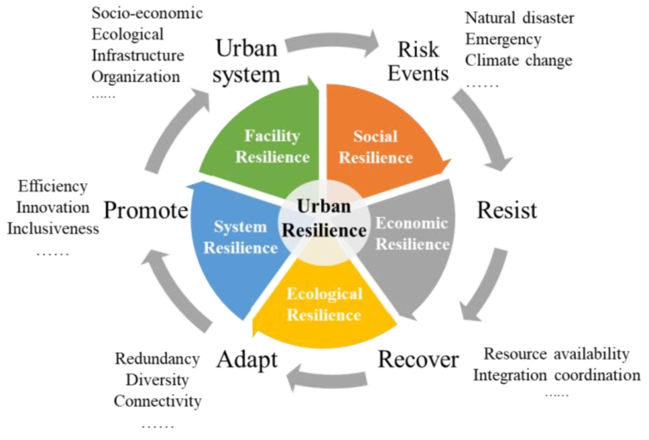
Figure 1. The connotation of a resilient city (source: author).
Sustainability 14 11929 g001
Figure 2. The hierarchy of urban-resilience computation simulation (source: author).
Sustainability 14 11929 g002
Figure 3. Architecture design of urban-resilience computation-simulation system for resilient urban planning (source: author).
Sustainability 14 11929 g003
Figure 4. Urban-resilience computation-simulation framework for resilient urban planning (source: author).
Sustainability 14 11929 g004
Table 1. Characteristics of reviewed literature on space–time scale, risk types, data indicators, and methods.
Most StudiesSome StudiesA Few Studies
Space–time scaleA single scale: country-level, region-level, and city-level scalesA single scale: city level and community levelMulti-scale: integration of macro, medium, and micro scales
Risk typesDisaster event: floods, earthquakes, hurricanes, typhoons, etc.Urban disturbances: climate change, urban growth, environment change, etc.Multidimensional scenario: multi-disaster coupling, multi-risk scenarios
Data
indicators
Traditional statistical data using questionnaires, expert scoring methods, etc.Geographic data, remote-sensing data and monitoring data using professional modelsMulti-source data: large-scale mobility data, social media, street-view images and POI, etc.
MethodsMathematical statistics: SEM, AHP, PRA, etc.
Spatial analysis: geographical detectors, spatial statistical analysis, etc.
Dynamic modeling methods: agent-based modeling, system-dynamics model, game theory, complex network model, etc.Other methods: semantic analysis, sentiment analysis, convolutional neural network (CNN), etc.
Publisher’s Note: MDPI stays neutral with regard to jurisdictional claims in published maps and institutional affiliations.