Review

Drone-Assisted Monitoring of Atmospheric Pollution—A Comprehensive Review

1
Faculty of Environmental Engineering, Department of Environment Protection Engineering, Wroclaw University of Science and Technology, Wybrzeże Wyspiańskiego 27, 50-370 Wrocław, Poland
2
calval.pl sp. z o.o., Emili Plater 7F/8, 65-395 Zielona Góra, Poland
*
Authors to whom correspondence should be addressed.
These authors contributed equally to this work.
Sustainability 2022, 14(18), 11516; https://doi.org/10.3390/su141811516
Submission received: 29 July 2022 / Revised: 1 September 2022 / Accepted: 6 September 2022 / Published: 14 September 2022

Abstract

:
Ambient air quality is a complex issue that depends on multiple interacting factors related to emissions coming from energy production and use, transportation, industrial processes, agriculture, and waste and wastewater treatment sectors. It is also impacted by adverse meteorological conditions, pollutants concentrations, their transport and dispersion in the atmosphere, and topographic constraints. Therefore, air pollutants distribution is not uniform and their monitoring at proper temporal and spatial resolution is necessary. Drone-borne analytical instrumentation can fulfill these requirements. Thanks to the rapid development in the drone manufacturing sector as well as in the field of portable detectors construction, applications of unmanned aerial vehicles (UAVs) for atmospheric pollution monitoring are growing. The purpose of this work is to give an overview of this matter. Therefore, this paper contains basic information on UAVs (i.e., description of different types of drones with their advantages and disadvantages) and analytical instrumentation (i.e., low-cost gas sensors, multi-sensor systems, electronic noses, high-accuracy optical analyzers, optical particle counters, radiation detectors) used for the monitoring of airborne pollution. Different ways of payload integration are addressed and examples of commercially available solutions are given. Examples of applications of drone-borne analytical systems for pollution monitoring coming from natural (i.e., volcanoes, thawing permafrost, wildfires) and anthropological (i.e., urbanization and industrialization; extraction, transport and storage of fossil fuels; exploitation of radioactive materials; waste and wastewater treatment; agriculture) sources are also described. Finally, the current limitations and future perspectives are discussed. Although there is a great potential for drones applications in the field of atmospheric pollution monitoring, several limitations should be addressed in the coming years. Future research should focus on improving performances of available analytical instrumentation and solving problems related to insufficient payload capacity and limited flight time of commonly used drones. We predict that applications of drone-assisted measurements will grow in the following years, especially in the field of odor pollution monitoring.

1. Introduction

One of the basic human needs is good air quality. Research on ice cores in Greenland has proven that the problem with its purity has been present for 2.5 thousand years [1]. Atmospheric pollution intensified with the industrial revolution in the 19th century and remains an issue to this day. Indeed, emissions associated with extraction and use of natural resources (e.g., uranium, coal, petroleum and natural gas) [2], transportation (e.g., car exhaust fumes, air and rail transport) [3], industrial activities (e.g., metallurgy, agriculture, food, chemical, pharmaceutical) [4], or household undertaking (e.g., home furnaces, waste collection and disposal) [5] are the main sources of anthropological air pollution today. Although natural pollution is of much lower concern, it cannot be neglected. Eruptions of volcanoes, geysers, forest wildfires, sand storms, thawing permafrost, or evaporation of swamps are important natural sources of pollution that emit diverse gases, particulate matter, and aerosols into the atmosphere [6]. Animals and plants also contribute to natural air pollution by adequately producing methane and releasing pollen [7,8]. Both anthropological and natural air pollution sources are considered in this paper. Many of the air pollutants are odorants whose emission is closely linked with different industry sectors (e.g., rearing animals, waste and wastewater treatment, chemical, food, tanning and refining industries) [9,10]. Increasing urbanization and industrialization will lead to an increase in this kind of activities meaning that more and more people will be exposed to the emission of different odorants [11]. Therefore, odors are classified as air pollution and will be addressed in this review as well.
Air pollutants are mainly absorbed by humans through breathing and contribute to the development of respiratory system diseases, as well as reproductive disorders and allergies [12]. In the case of radiation pollution, long-term exposure may affect living cells and damage their DNA. As a result, the cell may die or become cancerous [13]. Air pollutants also have a negative effect on the plant world as well, disrupting the processes of photosynthesis, transpiration, respiration, and reproduction [14]. Additionally, aerosols in the atmosphere can have a direct effect on climate by scattering and absorbing incoming solar radiation and indirectly influencing the radiative properties of clouds as cloud condensation nuclei. This can lead to local- (e.g., drought and insect outbreaks) and global-scale (e.g., greenhouse effect and ozone depletion) climate changes and contaminate water and soil (e.g., acid rains, which can be defined as any form of acidic precipitation that falls to the ground from the atmosphere in the form of rain, snow, hail, or even dust). This, in turn, increases the content of lead, copper, zinc, aluminum, and even cadmium in the water supplied to our homes [15].
Reduction of the emission of pollutants is a priority for many sectors of industry. However, it is also important to assure proper verification of the effectiveness of these efforts via monitoring of pollution level. Therefore, appropriate air quality standards have been established in many countries and measurement approaches for identifying key atmospheric species and air pollutants levels have been adopted [16,17].
Reference particulate matter (PM) monitoring uses gravimetric measurements based on the filtration and mass determination of the collected particles (difference in the weight of the used filter) to provide a time-weighted average PM concentration [18]. Real-time measurements of PM levels can be achieved with photo-detectors, which measure the light reflected from each particle (bigger particles reflect more light) [19,20]. Carbon monoxide (CO) and carbon dioxide (CO2) are usually measured by non-dispersive infrared (NDIR) light absorption methods based on the Beer-Lambert law [18,21]. Ammonia (NH3) and nitrogen oxides (NOx) can be measured by various techniques, including chemiluminescence [18]. The chemiluminescence method relies on the measurement of light produced during reaction (emitted photons), i.e., gas-phase titration of nitric oxide with ozone [22]. Most employed ozone monitoring instruments apply the UV photometry measurement principle [23]. With pressure and temperature compensations, the ratio between two different UV signals (one completely eliminating ozone molecules and the other passing directly through the measurement cell) gives accurate ozone measurements. The ultraviolet fluorescence method is typically applied for the determination of ambient SO2 concentration [18,24]. The measurements are based on the UV light absorption by SO2 molecules at a specific wavelength. Other sulfur compounds, including H2S, can be determined by gas chromatography (GC) with flame photometric detectors (FID) [25]. The GC methods with FID or PID (photo-ionization) detectors are also commonly used for volatile organic compounds (VOCs) analysis [26]. Radiation monitoring in the atmosphere can be achieved thanks to detectors based on ionization (e.g., Geiger–Muller counter) or excitation (e.g., scintillation survey meters) phenomena occurring due to the interactions between radiation and substances such as, respectively, inert gases and NaI(Tl) crystals [27].
In the case of odors investigations, instrumental methods tell us almost nothing about the perceived odor. For this purpose, one has to apply sensorial analyses. In dynamic olfactometry, odor concentration, expressed in ou/m3, is measured by presenting an odorous sample to a panel of strictly selected and regularly trained probants according to the specific norms (e.g., PN-EN 13725) [28]. The detailed description of this procedure can be found elsewhere and is out of the scope of this paper [29]. Real-time measurements of odor concentration can be achieved with electronic noses that have been properly trained with a panel of human noses [29,30]. Table 1 presents selected air pollutants, their characteristics, sources, and common ways of monitoring.
The threats caused by air pollution have a wide range of impact—they concern a spatial scale from local to global and a time scale from hours or days to many years. Therefore, monitoring of air quality requires continuous and real-time in situ measurements of the critical pollutants mentioned above. These requirements can be fulfilled by microsensors that can be installed on portable devices, monitoring networks and autonomous platforms [31]. Miniature detectors are in common use for PM, radiation, and certain gases, and theirs parameters have been improving. Sensors such as these were once expensive, but the 2010s saw a trend towards cheaper portable devices. A recent review by the European Commission’s Joint Research Center identified 112 examples of the so-called low-cost sensors, made by 77 different manufacturers [32].
In many countries, air pollutant levels over time are measured through air quality monitoring stations. In general, such systems provide systematic, long-term pollution assessment, depending mainly on the type of measurement station and local conditions at the site of interest [33]. Pollution monitoring stations are developed by many research groups (e.g., model air quality survey at the WUST campus [34,35]). Commercially available solutions also appeared recently (e.g., EcoClou, www.ecoclou.eu, accessed on 14 July 2022). The main drawback of this approach is that the monitoring takes place at a given measurement point representing the sources of emissions or background for a given region. Therefore, such a measurement lacks spatial characteristics, e.g., in the scope of analyzes of the concentration variability along with height. This gap can be filled with mobile platform monitoring systems [36].
Drones equipped with analytical instrumentation are useful tools for the monitoring of environment. Indeed, the number of scientific articles on the application of UAVs for atmospheric pollution monitoring is growing every year. This increase can be associated with significant progress made within the drone manufacturing sector, as well as in the field of development of low-cost and lightweight analytical instruments. This trend led to the appearance of first PM, radiation, and gas detectors specifically drafted for drone-assisted analyses or even drones already equipped with sensors on the market.
Several review papers on the matter appeared recently. Some of them present applications of drone-borne analytical instrumentation for radiation monitoring [27], mining industries [37], precision agriculture [38], or inspection of industrial sites [39]. A review on drone-based measurements of environmental motioning appeared in 2020 [40]. Since then, dozens of new original research papers have been published. Some new applications have been investigated as well, including those dealing with the monitoring of pollution coming from farming or agriculture. Recently, a new trend in drone-based measuring systems development appeared: integration of electronic noses on the UAVs for odor impact assessment. We took this into account and presented an example of such a setting. Additionally, a survey of commercially available solutions has been presented. We think that the present paper completes, summarizes, and systematizes the state of knowledge in this area from 2020 [40].
The motivation of this work is to give an overview on drone-based measurements of environmental pollution. Therefore, this survey contains basic information on UAVs and analytical instrumentation used for this purpose (Section 3.2 and Section 3.3). Different ways of payload integration are addressed and examples of commercially available solutions are given (Section 3.4 and Section 3.5). Examples of applications of drone-borne analytical systems for natural and anthropological pollution monitoring are also given (Section 4). Finally, the current limitations and future perspectives are discussed (Section 5).

2. Materials and Methods

In this article, a systematic analysis of essential publications and reviews regarding the application of unmanned aerial vehicles for air quality monitoring was performed. Google Scholar, Web of Science, and Scopus have been used to find relevant publications for this review. The research was based on a combination of following keywords in the titles, abstracts or keywords (and theirs acronyms): “unmanned aerial vehicle”, “drone”, “swarm of drones”, “aircraft”, “fixed wing”, “rotary wing”, “gas sensor”, “multi-sensor”, “electronic nose”, “amperometric sensor”, “photo-ionization detector”, “nondispersive infrared sensor”, “MOS sensor”, “laser absorption spectroscopy methods”, “cavity enhanced absorption spectroscopy”, “off-axis integrated cavity output spectroscopy”, “optical particle counter”, “radiation detectors”, “atmospheric pollution”, “methane”, “carbon dioxide”, “carbon monoxide”, “nitrogen oxides”, “ammonia”, “ozone”, “sulfur dioxide”, “hydrogen sulfide”, “particulate matter”, “volatile organic compounds”, “odor”, “odor mapping”, “remediation effectiveness monitoring”, “source localization”, “distribution mapping”, “radiation”, “thawing permafrost”, “volcanic eruptions”, “wildfires”, “urban area”, “traffic”, “industrial site”, “waste”, “wastewater”, “agriculture”, “livestock”, “smart city”, “heat and power plant”, “fossil fuels”, “coal mining”, “uranium mining”, “gas pipelines”, “natural gas”, “Fukushima Daiichi Power Plant”, “Chernobyl’s Power Plant”, “radiation source”, etc.
For Section 3, we have mainly selected review papers that presented detailed description of drones (i.e., their construction, classification, mode of functioning) and analytical instrumentation for air pollutants detection (i.e., low-cost gas sensors, electronic noses, multi-sensor systems, high-accuracy optical analyzers, optical particle counters, radiation detectors). During the preparation of this Section, we also performed a market search on drone-based solutions for air quality monitoring.
For Section 4, firstly, we rejected an important number of conceptual works and focused only on examples that demonstrated flight tests in real conditions. Secondly, we further narrowed down our search to papers that presented a detailed description of: (i) the investigated site (e.g., type, location, character of emitted pollution), (ii) the used set-up (e.g., type of drone, type of analytical instrumentation, payload integration mode), and (iii) the chosen flight mode (e.g., speed, range, flight patterns). Thirdly, we tried to select the most recent publications in the first place. Indeed, most of the cited papers (86%) in this Section have been published within the last 5 years. Finally, from all papers that met the above-mentioned criteria, we have chosen 37 that in our opinion presented the most diverse and interesting findings. We grouped these papers into six categories: (i) observation of natural atmospheric pollution, (ii) urban air quality monitoring, (iii) monitoring of pollution related to fossil fuels mining, storage and transport, (iv) waste and wastewater management, (v) agriculture pollution monitoring, and (vi) radiation monitoring, and provided a short description for every one of them.

3. Drones and Analytical Instrumentation

3.1. The Role of UAVs in the Air Pollution Monitoring System

Generally, the air monitoring solutions can be grouped into four categories: laboratory-based measurements, ground-based monitoring stations, and UAV- and satellite-based systems [41]. In the laboratory-based measurements, the air sample is firstly collected using an air sampler and then transported to the adequate facility for the determination of the level of selected pollutants. The sample is usually collected at the source (characterized by high concentrations of pollutants). The obtained results are then introduced to the dispersion models that estimate the extent of a given pollutant depending on meteorological conditions, topography, and vegetation. The main drawbacks of these methods are a lack of temporal and spatial resolution. Besides, the physical and chemical properties of the sample can evaluate shortly after sampling, and thus, have to be analyzed within 24 h. Moreover, the samples can be easily contaminated during sampling, transport, and analysis. For these reasons, the in situ monitoring stations equipped with adequate sensors and analyzers are found to be more useful and accurate [42]. Although the ground-based measurements are characterized by high temporal resolution, the spatial resolution is rather low. Moreover, they cannot cover national and global information. In order to do so, a dramatic increase in the number of monitoring stations is required, which is very expensive, and thus, unrealistic [41]. The drone-borne measurements can improve the spatial resolution (below 1 m) at a local scale, but still, the national and globe scales are out of our reach due to the costs requirements associated with the installation and maintenance of such complex systems [43]. Other drawbacks of UAV-based solutions are the low payload of small drones, limited flight duration, and the so-called dawn-wash generated by the rotors (see below). If air quality data on a national or global scale are required, then the best solution is to use a satellite-based sensor system that allows monitoring of several pollutants, including PM, CO2, SO2, NO2, CO, or O3 with a spatial resolution of 5.5 × 3.5 km. A temporal resolution of 60 min is typical for geostationary sensors such as Sentinel-5 missions [44]. It is hard to compare the methods describe above, since each one of them provides a different type of information. Therefore, the best choice is to use them simultaneously as complementary approaches to a given task, and thus, obtain maximum information [45].

3.2. Types of Drones

Two main groups of UAVs can be distinguished: fixed wing (FW) and rotary wing drones (RW). Depending on the number of rotors, the RW drones can be further divided into single rotor vehicles, tricopters, quadcopters, hexacopters, or octocopters [46]. However, for atmospheric pollution monitoring applications, small-scale vehicles with four or six rotors are generally preferred [47]. An interesting solution is to combine the principle of FW and RW construction. The hybrid approach combines advantages of both systems, e.g., vertical take-off and landing (VTOL) with high speed flight, characteristic for adequately RW and FW vehicles [48,49].
Indeed, the FW drones can fly at high speeds, and therefore, cover large areas throughout one flight. The main limitation of these vehicles is low payload capacity. They also require a launch system or a runway for take-off and landing. Since they move relatively fast, the spatial resolution of the achieved measurements is usually low [47]. However, this factor depends also on the response time of the on-boarded analytical instrumentation. For the same reason, they cannot be used for applications that require slow-speed flights, such as the investigation of urban and industrial areas.
The RW drones are free of these limitations because they operate at lower speeds and are easy to maneuver, partially thanks to their VTOL capacities [50]. However, due to their low speed and flight range, investigations of large areas usually requires several flights, which is time-consuming and expensive. Indeed, the flight time of a typical rotary wing drone is only circa 30 min and can be shortened when fully loaded [51]. The biggest drawback of this type of drone is, however, the so-called down-wash, i.e., a strong perpendicular airflow generated by the rotors. This phenomenon can cause disruption of air distribution around the drone, and thus, has an impact on the performance of on-board sensors [52,53]. Although this effect is negligible a few dozens of centimeters above the drone or in the vertical directions, the down-wash can extend to a few meters below the vehicle [54,55]. This local mixing is especially undesirable when performing measurements across strong spatial gradients. Different types of UAV are schematically represented in Table 2.
Traditional applications of drones necessitate manual remote radio control over the flight of the vehicle. In this case, the operator regulates the flight controller parameters to assure security and maneuverability of the UAV. As the complexity of the operations involving drones increases some of the tasks can be disburdened to the onboard flight controller (e.g., collision detection and altitude control). A fully autonomous system assures execution of the mission without human intervention and without necessarily involving communication with the ground station (e.g., pre-programmed missions) [50]. In the case of partially or fully autonomous operations, the drone tracks its current position thanks to the global navigation satellite system (GNSS) receivers, i.e., GPS [56,57]. The stability of the flight is assured by different sensors: barometers (for altitude determination), ultrasonic, LIDARs, cameras (for distance estimation from different objects), and IMUs (to track orientation) [46].

3.3. Analytical Instrumentation

Due to the limited payload capacity of small UAVs, lightweight and power-efficient systems are required for drone-assisted monitoring of the environment. To date, several analytical instruments have been successfully deployed for this purpose, i.e., low-cost single gas sensors, multi-sensor systems, electronic noses, high-accuracy optical analyzers, radiation detectors, and optical particle counters for particulate matter concentration.

3.3.1. Low-Cost Gas Sensors

Gas sensors are analytical devices that provide real-time information on the concentration of gases in contact with the sensor. They are characterized by small size, low weight, and low power requirements, and therefore, can be easily integrated on portable devices, monitoring networks, and mobile platforms [58]. Among many possible solutions, amperometric sensors (APS), metal oxide chemiresistive sensors (MOS), non-dispersive infrared sensors (NDIR), and photoionization detectors (PID) are the most popular (Figure 1). A detailed review of different gas sensors for environmental applications can be found in the literature [58,59,60,61]. Therefore, we will provide only a brief description of each principle of detection here.
Amperometric sensors are made of three electrodes, i.e., the working (WE), the reference (RE), and the counter electrode (CE). Reduction or oxidation of molecules of interest at the WE causes changes in the measured current flow, which are proportional to the target gas concentration in the analyzed sample (Figure 1a) [58]. Thanks to the application of chemical filters, different catalysts, or modification of the working electrode surface, these detectors are highly selective and quite sensitive. APS are usually applied for the detection of O2, CO, O2, SO2, NO, NO2, NH3, and H2S at ppb or ppm levels [62]. The main disadvantages of these devices are: slow response and recovery time, baseline drift, and limited lifetime. Most APS can operate only for about 2 years due to the use or evaporation of the electrolyte. However, some companies offers sensors that can last five times longer (e.g., TGS 5141 from Figaro Engineering Inc., Mino, Japan) thanks to the application of solid electrolytes. As recent articles suggest, baseline drift of the APS caused by the variation of ambient humidity and temperature can be compensated using multivariate predictive models [63,64,65].
Chemiresistive gas sensors are characterized by very simple configuration. The sensitive layer, made usually of semiconducting metal oxides, is placed between two electrodes or on top of an interdigitated electrode (Figure 1b). The reduction and oxidation of the target gas molecules on the sensitive layer leads to the resistance changes of the sensor [60,66,67]. Most of the MOS sensors work at high temperatures (up to 500 °C), and therefore, require a heating element installed below the electrodes and separated from them by an insulating membrane. As a consequence, these sensors consume relatively high amounts of power. However, thanks to the MEMS technology, the energy requirements can be decreased from 100 mW to only 10 mW [68]. A lifetime of 10 years is typical for MOS sensors, but at the same time, these sensors are susceptible to humidity changes and can be deactivated by important concentrations of volatile fatty acids or sulfur compounds. Although they are dedicated to the measurement of VOCs at ppm or sub-ppm levels, MOS can be also used as an interesting alternative for the detection of inorganic gases [69]. The selectivity of the MOS sensors is much lower as compare to the amperometric ones, but can be improved by the application of multivariate predictive models, heating temperature modulation, doping the metal oxide surface with noble metals, or application of chemical filters [70,71,72,73]. The response time of typical MOS varies from 10 to 20 s, which is three times faster than for the amperometric devices.
The main component of the NDIR sensor is a source of infrared radiation in alignment with a detector (Figure 1c). When the target molecules absorb radiation of a specified wavelength, a reduction in light intensity reaching the detector can be measured. This change is proportional to the concentration of the gas of interest. The selectivity of the set-up is guaranteed by an optical filter, which lets through absorbed light of specified wavelength [74]. Similarly to the APS, the NDIR sensors are highly selective and are widely used for the detection of CO2. Although CH4 sensors based on NDIR technology exist on the market, cross-sensitivity with other hydrocarbons is a common problem [75]. Since the measurement principle is based on physical properties of the target molecule, the NDIR sensors do not suffer from baseline drift and are not susceptible to poisoning. At the same time, these devices are more expensive and consume more power than other low-cost gas sensors.
The PIDs are examples of low-cost sensors that are often used for the analyses of atmospheric pollution. Radiation emitted by the UV lamp causes ionization of the target molecules and the presence of the as-generated products is recorded by an electrometer (Figure 1d) [58]. PIDs are not selective and, therefore, can detect a wide range of VOCs and some inorganic gases [76]. However, molecules with ionization energy higher than the energy of the emitted photons cannot be detected with this approach (e.g., CO, CO2, SO2, O3). Usually, PIDs can cover wide range of concentrations (10 ppb–10,000 ppm) with a response time of just a few seconds. In some miniaturized versions of PIDs, the response time can drop to few milliseconds [77].
A comparison of different types of single gas sensors is presented in Table 3.

3.3.2. Multi-Sensor Systems

An interesting approach is to combine a few types of sensors simultaneously, which allows monitoring of several gases at the same time [78,79,80]. Multi-sensor systems host several gas sensors and contain all necessary electronics, gas transmission paths, data acquisition, and power management systems. Some of the multi-sensor systems contain their own battery, and thus, work autonomously. Other devices obtain energy from drone batteries and are usually compatible with specific drone models. In this case, the set-up is lighter. Multi-sensor systems host usually up to 10 single gas sensors and weigh up to 2 kg. Due to their low selectivity, MOS are used less frequently than other gas sensors. Several multi-sensor systems are available on the market, e.g., X-am 8000 analyzer from Dräger, Lübeck, Germany (www.draeger.com, accessed on 14 July 2022) or RAE Systems (www.raesystems.com from Honeywell, San Jose, CA, USA accessed 14 July 2022). Some of them can be configured by the user, while others are designed for a specific application. Multiple research groups developed their own multi-gas systems in order to meet some specific needs [81,82].

3.3.3. Electronic Noses

Several detailed review papers on electronic noses (EN) have been published recently, so we will provide a brief description of these systems [30,68,83,84]. Typically, an e-nose is made of several semi-selective gas sensors (usually MOS sensors). The interactions of gaseous molecules with the sensing array give rise to analytical signals, which are very complicated and have to be processed with the pattern recognition programs [68]. THe development of an EN is a demanding task and can be influenced by many factors, usually related to the choice of sensors, development of models, and quality of data used for their training. Most EN systems are composed of several MOS sensors, but some of them can be additionally equipped with other types of sensors [30]. ENs have been applied in many fields: food quality [85,86], agriculture [87] and industry [88], disease detection [89], and drugs and explosives detection [90,91]. ENs are also widely used for the monitoring of outdoor and indoor air quality [92,93,94]. Examples of commercially available e-noses are presented in [30].
ENs suffer from the same drawbacks as the sensors from which they are made. If one of the sensors will drift in time, then the whole sensing array will drift as well [95]. Correcting the EN drift is more complicated than in the case of a single sensor [96,97] and periodic re-calibration of the system may be necessary in order to maintain high accuracy [98]. Moreover, in case of a failure of one of the sensors, replacement with another one is often impossible. This is due to the low reproducibility of the MOS sensors’ fabrication. Power consumption can also be an issue, especially when all sensors in the array work at the same temperature.The sensor chamber, which is required to hosts all sensors, increases the response time of the EN. For these reasons, most EN systems operate under strictly controlled laboratory conditions with long measurement cycles. For drone applications, it is, therefore, necessary to design a small sensor chamber that will decrease the response time of the EN.

3.3.4. High-Accuracy Optical Gas Analyzers

High-accuracy optical gas analyzers produce absorption spectra of analyzed molecules when these are irradiated with infrared or ultraviolet light. Therefore, the principle of detection is similar to the NDIR sensors described above, but thanks to sophisticated components, such as lasers, reflectivity mirrors, quartz-coated cavities, or temperature and precision compensation systems, these analyzers usually provide high-quality measurements with lower detection limits and higher accuracy. On the other hand, additional components make these detectors heavy, expensive, and power hungry instruments. For example, an NDIR CO2 low-cost sensor from Alphasense (Great Notley, Essex, UK) weighs 15 g and requires 5V DC (www.alphasense.com, accessed on 14 July 2022), whereas the LI-850 CO2 infrared analyzer from LI-COR Inc. (Lincoln, NE, USA) weighs 1.3 kg and requires up to 30 V DC (www.licor.com, accessed on 14 July 2022). A comparison of traditional low-cost gas sensors with high-accuracy optical analyzers is provided in Table 4.
Similarly to the NDIR sensors, laser absorption spectroscopy methods (LAS) allow selective detection of some gases, but the optical filters are not required. The most frequently applied LAS technique, i.e., the TDLAS, is based on a tunable laser diode (TDL). The wavelength of the laser is adjusted over a specific absorption line and the intensity of the transmitted radiation is measured. The transmitted intensity is related to the concentration of the target gas by the Beer–Lambert law [99]. The measurement can be performed with the laser beam operating in closed-paths designs (CP-TDL) or via open atmospheric paths (OP-TDL) [100]. In the first case, high accuracy can be achieved, but the response time is usually longer than for the OP-TDL setting [99]. The TDLAS technology is widely used for measurements of moisture (H2O), CO2, H2S, NH3, or C2H2 [97,101,102].
Modifications of the TDLAS technology led to the development of some new methodologies, such as back-scattered TDLAS (sTDLAS). In sTDLAS, the emitter and detector are situated on the same side of the optical path (Figure 2a). The laser beam travels through the air towards the ground, is scattered from it, and finally, reaches the detector [103]. In comparison to traditional OP-TDL systems, the detector measures cumulative gas concentration across the beam, gathering information over a large area with a single measurement.
Cavity-enhanced absorption spectroscopy (CEAS) is yet another approach that uses an optical cavity inside which the light rebounds before reaching the detector (Figure 2b). The most popular techniques using this setting are cavity ring-down spectroscopy (CRDS) and off-axis integrated cavity output spectroscopy (OA-ICOS) [104,105]. Both technologies are very sensitive, but due to their weight and power requirements, were not suitable for drones until recently. The CRDS instrument developed by Martinez et al. [106] can detect methane with a detection limit of 30 ppb and a response time of 1 s. The OA-ICOS proposed by ABB Group from Zurich offers an even lower detection limit (below 1 ppb) and a shorter response time (0.2 s) [107]. Both instrument were deployed on drones recently for the detection of methane emissions [106,107].

3.3.5. Optical Particle Counters

Historically, particulate matter was measured by gravimetric methods. This technique uses a pre-weighed filter to collect particles of a specific size. After one day, the filter is weighed again in order to estimate the accumulated PM mass in µg. This mass is then divided by the total air volume that passed through the filter, giving the mass concentration value expressed in µg/m3. Gravimetric instruments are very big and quite expensive, process only one PM size at a time (e.g., PM2.5), cannot perform real-time measurements, and they cannot output the particle number count. Obviously, they cannot be applied for the drone-assisted monitoring of particulate matter in the air [108]. For this purpose, the optical particle counters (OPC) are suitable.
An OPC detects particles by measuring the quantity of light scattered by the individual particles as they pass through a laser beam. Results are generally reported as particle counts per milliliter of the sample with particles grouped according to size (Figure 3). The OPC are subject to estimation errors resultant from the diverse optical properties of the analyzed particles, i.e., shape and color and their different mass densities. Therefore, the quality of the measurements depends on the manufacturer algorithm developed to convert the acquired optical signal into PM mass concentration. In addition, the internal airflow engineering has a high impact on these sensors’ performance as particles can accumulate easily on their optical components, and thus, cause drift of these sensors in time and worsen the measurement accuracy [77,109]. A miniaturized version of OPC is available for instance from Alphasense. The OPC-R2 model weights less than 30 g and requires 5 V DC (www.alphasense.com, accessed on 14 July 2022).

3.3.6. Radiation Detectors

Radiation monitoring in the atmosphere can be achieved thanks to detectors based on ionization or excitation phenomena [27,110,111]. The Geiger–Muller (GM) counter survey meters and ionization chambers are filled with inert gas (e.g., helium, neon, or argon) (Figure 4a). When radiation passes through the chamber, it leads to ionization of the gas atoms, producing positive ions and electrons. These ions and electrons are attracted to the suitable electrodes, giving rise to a current flow. The latter is then converted into electric signals, which are finally measured as the amount of radiation [112]. The GM detectors and ionization chambers are capable of detecting alpha, beta, and gamma radiation [113]. However, this instrument is less sensitive to gamma radiation.
The NaI (Tl) scintillation survey meters utilize excitation phenomena. When radiation passes through the detector, molecules within the scintillator are excited, but return shortly after that to their original state. Light emitted during this process is magnified thanks to the photomultiplier and then transformed into an electric signal to measure radiation (Figure 4b) [111,114]. Aside from NaI (Tl) scintillation survey meters, germanium semiconductor detectors are widely used for radiation measurement [115,116]. These detectors, unlike the GM ones, are capable of detecting low-energy gamma radiation. At the same time, scintillation counters require higher voltages to function and are comparatively larger and more expensive that GM counters.

3.4. Instrumentation Integration

From a wide variety of gas sensors and analyzers presented above, the OP-TDL-based devices, especially sTDLAS detectors, are fully compatible with the FW drones. The response time of these devices can be as low as 0.1 s. These detectors are usually mounted on the nose or under the wings of the vehicle [117,118], but more original settings are also proposed [119]. In this approach, the laser and detector were placed on the wings of the drone creating an optical path between them. The system has been commercialized by Boreal Laser, Edmonton, Canada.
Installation of analytical instruments on RW drones is more complicated due to the discussed above down-wash. Although the performance of sTDLAS analyzers is unaffected by this phenomenon, other sensors may, for example, underestimate concentrations of measured gases [120]. Therefore, the sTDLAS analyzers can be attached directly below the body of the drone [121] (Figure 5a,b), but for other sensors, more sophisticated approaches must be applied in order to obtain gas concentration measurements with good accuracy. The down-wash is the weakest in horizontal directions. Therefore, many research groups place theirs measurements systems on a boom that allows the sampling of unperturbed air (Figure 5c). This approach, however, destabilizes the gravity center of a drone, and thus, makes it aerodynamically inefficient [122]. Another solution is to use pumping systems with an inlet placed away from the platform (Figure 5d,e). Designs with horizontal or vertical sampling tube were applied by many researchers [55,123]. This approach is also widely used in commercial systems (e.g., AirDrone, SnifferDrone, Scentroid DR1000, Aeromon BH-12). The main drawback of this method is that the application of long tubes may cause an increase in response time due to the adsorption of certain gases on the inner walls of the tubes.
For approaches that do not require detection of gas concentration with high accuracy, the payload may be mounted directly on the drone body, but for obvious reasons, bottom mounting is to be avoided. For this purpose, small low-cost sensors are often placed in front of rotors [124,125] or are attached to the top of the UAV [126] (Figure 5f).

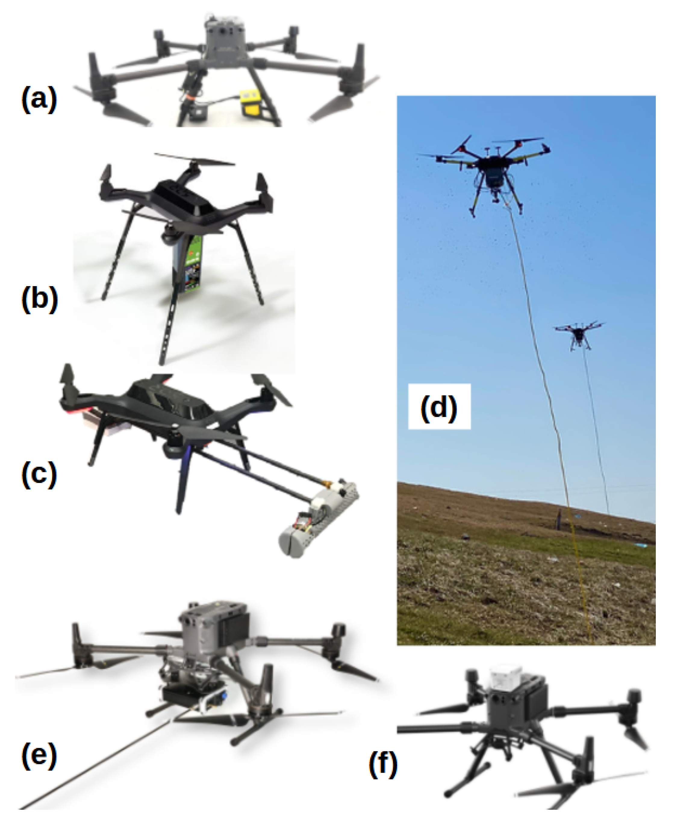
3.5. Commercially Available Drone-Borne Systems for Environmental Monitoring

Rapid development in the field led to the appearance of the first drone-borne monitoring systems on the market (Table 5). Several companies propose solutions for urban air quality monitoring (e.g., AirDrone, Sniffer4D) and detection of gas leaks or gas mapping over landfills, pipelines, and related industries (SnifferDrone, SkyHub, HoverGuard). In many countries, drones are widely used for the inspections of smoke coming from chimneys in order to test for chemicals, indicating the use of low-quality burning material (low-quality coal, wastes, etc.).
Some of the proposed systems are equipped with high-accuracy gas analyzers for rapid and precise detection of a chosen gas, mainly methane (e.g., SnifferDrone, SkyHub, HoverGuard). Others offer the possibility for multiple gas detection. In that case, the number and type of sensing modules can be customized for specific applications (AirDrone, Sniffer4D, DR2000). Drones dedicated for the monitoring of radiation are proposed, among many others, by Kromek and NUVIAtech Instrument companies.

4. Selected Applications

4.1. Observation of Natural Atmospheric Pollution

Thawing permafrost, volcanic eruptions, and wildfires are important natural sources of GHGs and other gaseous pollution as well as particulate matter. Several drone-assisted field missions were performed in order to estimate emissions of these pollutants into the atmosphere (Table 6).
Methane escaping from thawing permafrost in Arctic regions is intensively studied, especially in the context of global warming. Recent drone-assisted surveys of CH4 emissions from these regions proved the superiority of the proposed approach over traditional ground-based sampling methods or satellite-based measurements. For example, a sTDLAS analyzer, i.e., the Pergam Methane mini-G (SA3C50A), installed on the 3DR Solo drone, was used for the identification of “hot spots” of methane fluxes along the coastal permafrost of Barter Island, in Alaska [121]. Indeed, high spatial variability of methane levels was achieved over the site of interest. The identified “hot spots” were associated with topographic features or anomalies, proving that traditional point sampling is insufficient when investigating methane releases.
More recently, Scheller et al. [127] prepared a methane concentration map over Zackenberg Valley, Northeast Greenland. The measurements were performed with the LI-COR LI-7810 NDIR analyzer linked to a DJI Phantom 4 Pro RW quadcopter with a 100 m long PVC tube. This unusual set-up required two persons to operate. Identified “hot spots” and “cold spots” were in agreement with high and low emissions of methane noted during traditional campaigns in previous years. The authors suggested that such methane concentration maps are useful tools for selecting more representative flux monitoring sites in the future.
Volcanoes are natural sources of several air pollutants, including reactive gases (e.g., SO2) and GHGs (e.g., CO2). Drone-assisted monitoring of volcanic plumes provides an interesting option for well-established ground-based measurements, as they can transport gas detectors or samplers directly into the plume, and thus, eliminate the risk to humans [78,128,129,130,131]. For example, the authors of [128] developed a multi-gas system composed of an amperometric sensor for SO2 and NDIR detector for CO2 monitoring. The system was installed on Black Snapper, Globe Flight RW quadcopter. The setting was used at three different sites (Stromboli, Turrialba, and Masaya volcanoes) for the compositional analysis and gas flux estimation of volcanic plumes. Generally, authors showed the applicability of the developed system for potential UAV-based monitoring. However, they also pointed out that it is difficult to obtain high-quality data for diluted samples with low-cost sensors. The authors suggested that with more sophisticated and expensive constituents (e.g., sensors, microcontroller or data logger) it would be possible to achieve better sensitivities, but with the risk of greater losses in the event of an accident.
Liu et al. [129] demonstrated the efficiency of the UAV-based gas measurements for investigating short-timescale variability in volcanic outgassing and plume transport processes. An octacopter (Vulcan UAV Ltd., Mitcheldean, Gloucestershire, UK), equipped with customized multi-sensor system, was used in order to investigate early plume evolution. Good agreement between time-averaged molar gas ratios obtained from simultaneous UAV- and ground-based multi-gas acquisitions was achieved, but the first set-up was more efficient in determining active degassing events.
More recently, Sasaki et al. [131] implemented an anemometer, a PM sensor, and a multi-sensor system on a SPIDER CS-6 hexacopter for the monitoring of vertical wind profiles, particulate matter, and gas concentrations at altitudes up to 1000 m around Mt. Sakurajima (Japan). Observations revealed high concentration peaks of PM appearing intermittently during or after explosions across all analyzed altitudes and especially at the downwind side. Furthermore, the concentration of coarse particles (PM10) increased significantly during these spikes.
An interesting application of an octocopter (DJI S1000) equipped with a single SO2 electrochemical sensor was presented in [130]. The set-up was used as an automatic sampler in which a signal from the sulfur dioxide sensor activated a pump to collect samples when the SO2 level exceeded a certain predefined level. The authors showed that by applying the drone-assisted sampling at Aso volcano (Japan), it is possible to collect plume samples richer in H2 and CO2 concentrations as compared to the direct sampling in flasks at the crater rim. Therefore, drone-assisted sampling was more advantageous, since collected samples were analyzed later on for the 2H and 18O content in the fumarolic gas.
Wildfires are yet another source of atmospheric pollution associated mainly with CO2, CO and particulate matter emissions. Since it is impossible to predict the time and place of the next natural fire occurrence, the feasibility of using drones for such investigations was explored for instance in a smoke plume from a simulated wildfire [132]. More recently, the same team performed detailed measurements of several parameters during the prescribed burn of Fishlake National Forest, Utah in June 2019 [133]. Hexacopter equipped with the “Kolibri” system (composed of sensors and samplers) performed 16 flights over 3 days. As expected, differences in emitted pollutants were noted between slash piles (lower PM2.5, TC, and NO2) and standing forests made of the same species. This suggests that the experimental conditions were close to the natural ones and proves that the drone-assisted monitoring of such events is feasible without placing equipment at risk and ensuring personnel safety.

4.2. Urban Air Quality Monitoring

Although there are some natural origins of urban air pollution, most of the sources are anthropogenic, including transportation, domestic use of fossil fuels, industrialization, or power generation. The quality of urban air is indicated by the quantity of certain pollutants in the air, such as ozone, particulate matter, sulfur oxides, nitrogen oxides, carbon monoxide, and Volatile Organic Compounds. Recent studies showed that drone-borne analytical instrumentation is a powerful tool to investigate the problem of urban pollution (Table 7).
For example, drone-assisted measurements provide data at a much higher spatial resolution than those performed on ground-base environmental stations, as suggested by [134]. The authors mounted the optical DSM501A sensor on a TAROT 680PRO platform and tested its performance in the vicinity of the Faculty of Engineering, Universiti Putra Malaysia. The constructed PM2.5 monitoring system was described as a small, light-weight, and low-cost solution for dust monitoring in urban areas.
Chodorek et al. [135] developed a pollution monitoring system named Kestrel based on a quadcopter and low-cost sensors, which included the Seeed Studio HM3301 laser dust sensor for PM2.5 detection and several semi-selective MOS sensors (Winsen) for VOCs and some inorganic gases detection. The overall system was designed to measure the concentrations of exhaust gases originating from cars. Field experiments were performed at a parking lot of the AGH University of Science and Technology (Kraków, Poland). The described system was able to detect excessive exhaust emission events associated with car circulation and provides good situational awareness.
Particulate matter (PM10, PM2.5, and PM1), ultra-fine particles, black carbon, and meteorological parameters were also measured in the vicinity of roadside using a DJI Matrice 600 equipped with adequate detectors by Samad and co-authors [136]. Firstly, the authors adapted the positioning of the detectors on the drone and then performed several vertical and horizontal profiles of the chosen pollutants. The obtained result showed, as expected, that the pollution level was the highest in the vicinity of the emission source, i.e., near the roads, and decreased to background concentrations with increasing distance (both vertically and horizontally). Moreover, the investigations have shown that the meteorological conditions impacted the pollutants levels. High wind speeds assisted the dispersion of the pollutants, whereas increased temperatures facilitated the convection of air masses, assuring efficient vertical mixing of the pollutants.
In [137], the authors deployed appropriately equipped drones to measure H2S and PM levels (PM10, PM2.5, and PM1) in the air around a library building belonging to the Lodz University of Technology, Poland. A DJI Matrice 600 with an electrochemical sensor for H2S and a laser scatter sensor for solid particles detection was used for these investigations. The set-up was also equipped with a 1.5-meter probe in order to eliminate the down-wash effect caused by the drone. The measurements were made in a grid consisting of 30 measurement points located around the library building at two different heights, i.e., 10 m and 20 m. The obtained spatial distributions of the selected pollutants were consistent with the theory of air aerodynamics around buildings, which is directly responsible for the transport of pollutants in urbanized areas.
In [123,138], the same authors used a similar set-up to the one described above in order to analyze air quality around Heat and Power Plants (Łódź, Poland). In [138], the authors were investigating gaseous pollutants (H2S, SO2 and VOCs) and particulate matter levels (PM10, PM2.5, and PM1) at two places in the neighborhood of a solid fuel heat and power plant: one in the vicinity of an air quality measuring station located around residential areas and one at the intersection of two large streets. The measurements at selected points were made at specific grids and with a given altitude profiles. Thanks to this approach, the authors were able to obtain the spatial distribution of selected pollutants fractions and determine the origin of those fractions.
In [123], drone-assisted measurements of PM10 and SO2 concentrations were compared with the numerical analysis of spatial dispersion of these pollutants (performed also by the authors). The obtained results showed that the air quality in selected areas was influenced by the emission of dust from the additional sources, such as transportation or individual heating systems, which caused it to exceed the permissible level of the pollutants in the air.
In De Fazio et al. [80], the authors proposed an advanced drone-based monitoring system for air and noise pollution. As a base for the system, the DJI Phantom 3 drone was used. The payload included several sensors to analyze the chosen environmental pollutants (i.e., CO2, CO, NO2, NH3, VOCs, PM2.5, and PM10) at a high temporal resolution. Moreover, an onboard microphone and adequate algorithm was used to quantify the noise level. The drone was also equipped with a camera and used visual recognition algorithms to detect fires and localize them by a GPS receiver. Finally, a cloud application was developed for uploading the data provided by the drone patrolling. During the field tests, it was proven that the developed UAV system with selected PM sensors was able to obtain environmental data with low economical costs and in a non-invasive way.

4.3. Monitoring of Pollution Related to Fossil Fuel Mining, Storage, and Transport

Mining and quarrying include the extraction of natural resources in a solid (e.g., coal, ores), liquid (petroleum), or gas (natural gas) form. Activities such as hauling, blasting, and transportation emit gases and particulate matter to the air and are characteristic for surface mines. On the other hand, emissions of CH4 from the ventilation shafts are typical for the underground coal mines. These emissions can be measured directly from the atmosphere. For this purpose, drone-based measurements have been performed by several research groups (Table 8).
For example, the authors of [139] focused on the development of a setting suitable for PM10 concentrations monitoring originating from surface mining activities. The instrument was based on a drone IRIS+ from the 3DR company and an optical particle counter OPC-N2 from the AlphaSense company. The authors indicated two main issues related to the air sampling with the use of UAV: problems with obtaining isokinetic flow, and the design of air sampling path and finding the optimal position for it in the UAV build. During the tests that allowed to observe the behavior of the air around UAV propellers, researchers were able to find out that the vertical probe with an inlet situated at a distance of 47.5 cm from the center of the UAV was the optimal position to maintain proper air sampling. The position of the measuring probe was different from the solutions adopted by a majority of applications discussed in this overview. During the different calibration tests and comparisons with the reference PM monitoring system, the authors have concluded that it is possible to obtain emission factors with good agreement.
In Andersen et al. [140], the authors investigated methane emissions from underground coal mining ventilation shafts. For this purpose, a drone-borne CRDS CH4 analyzer installed on DJI Inspire 1 was used in the Upper Silesia Coal Basin in Poland. The authors used an inverse Gaussian distribution and mass balance approaches for the estimation of the CH4 emissions with both simulated and in situ data (i.e., acquired using UAV-based measurements). Obtained results demonstrated that the drone-based system is a useful tool for quantifying the emissions of CH4 and CO2 from the coal mining shafts. At the same time, these investigations revealed that the achievement of high-quality data requires multiple transects at several altitudes with appropriate vertical distances between the individual transects and a proper spacing between the center of the plume and the center of the flight transect.
The main component of natural gas, i.e., methane, has negative impacts on the environment. Oil and gas industries dealing with important amounts of methane have to face the problem of its emission and leakages to the atmosphere on a daily basics. It is, therefore, very important to have the means for rapid identification of such events. For example, in Iwaszenko et al. [141], the authors successfully applied a drone-borne sTDLAS analyzer for the detection of natural gas leakages from buried pipelines. In order to achieve high accuracy, the measurements had to be performed at flight altitudes between 4 and 15 m above the ground. These results were in agreement with investigations performed earlier [142], in which a similar set-up was used to detect subsurface and surface methane leaks. The authors also reported that the system was not able to discriminate between low and high concentration methane plumes. This problem was associated with the specificity of the sTDLAS instrument, which gives information over the whole air column that the laser beam is shot through. This issue can be neglected by preforming several flights at different heights in order to obtain a rough estimate of the vertical concentration profile.
Although multiple examples of natural gas leak detection using drones appeared in the literature and several commercially available solution exist on the market, new approaches are still developed. For example, in [119], the authors proposed an integrated UAV-based set-up for spotting leaks of methane from a natural gas networks. The FW aircraft with a 2.3 m wingspan was used for this purpose. The methane analyzer is an open-path laser spectrometer, with the laser beam traveling across the winglets of the vehicle. The design applies a retro-reflector in order to eliminate laser alignment problems and improve durability. This shortens the laser path, and thus, limits the measurement precision. However, in this particular case, the need was for a preliminary, inexpensive, and fast identification of large releases of methane, rather than for high-precision and -accuracy analyses.
In order to increase the efficiency of gas leaks detection, several UAVs may be used at once, as described by Tosato and co-authors [143]. The authors developed a coordinated swarm of drones equipped with adequate sensors for industrial applications. The UAVs were commanded by a ground station that controlled the total working volume. During the mission, the path of each vehicle was elaborated and assigned by an coverage algorithm. The effectiveness of the whole system was proved with both real gas leakage and simulated ones.

4.4. Waste and Wastewater Management

Methane emission can be also associated with waste and wastewater management processes. Several interesting applications of drone-borne instrumentation for methane emission monitoring have been proposed recently (Table 9). For example, in Montoya et al. [144], the authors deployed a drone-based set-up equipped with low-cost MOS sensors for detection of CH4, CO, and CO2. The authors have carried out laboratory and field measurements with promising results for further development.
Even after several years, some closed landfills may release methane into the atmosphere, as suggested in Daugela et al. [145]. The authors used optical imaging sensors and two types of drones: an RW quadrocopter and a fixed-wing vehicle to find that although the topology of the investigated site does not change through the years, the landfill still possess an environmental issue. Indeed, measurements performed with handheld gas detector confirmed the presence of several methane “hot spots” during on-site investigations. Although the developed gas-sensing array was used in this study as a handheld instrument, it has a full potential to be mounted on the drone for remote measurements. This approach should be affordable for landfill operators and, with further development, could be used to quantify fugitive CH4 emissions over an entire landfill surface.
Methane emissions from sludge were also investigated by Gålfalk et al. [146] by using a mid-IR laser gas sensor mounted on a DJI Matrice 210 platform. Data from horizontal transects were used to map and spot emission sources of methane over vast areas. Additionally, measurements from vertical flight patterns were used for total CH4 flux calculations using mass balance approaches. The authors highlighted that their method is general and can be used for other applications.
Methane is one of a wide spectrum of molecules that are emitted as pollution during the waste and wastewater treatment processes. The following other substances may be considered as a threat: NH3, NOx, H2S, HCl, HF, CO, CO2, furans, dioxins, VOCs, and PAHs. Some air pollutants may be odorants, and their emission is one of the most important issues associated with these plants. An attempt to monitor these odorants was made by Burgués et al. [79], who applied the commercially available multi-sensor system Dräger X-am 8000 and a home-made electronic nose for gas concentration measuring and mapping and for the discrimination of odor sources.
The same authors described another set-up for the odor concentration mapping at the site [55]. This time, the electronic nose was made from APS and MOS gas sensors. The set-up was additionally equipped with a remotely operated vacuum sampler (for 10-L Nalophan bags) for the collection of samples for olfactometric measurements. The so-called RHINOS e-nose allowed odor determination with high spatial resolution and good accuracy. To the best of our knowledge, it was the first reported attempt of odor concentration estimation from drone-based measurements.

4.5. Agriculture Pollution Monitoring

Common pollution from agricultural activities include PM2.5, PM10, ammonia, methane, nitrous oxide, and odors. From those mentioned above, NH3 emissions are of the highest concern. Ammonia enters the air from heavily fertilized fields and livestock waste. It combines in the air with combustion emissions to form solid particles. Agriculture also consumes fossil fuels for farm activities and fertilizer manufacturing, and thus, produces carbon dioxide (CO2), nitrogen (NOx) and sulfur oxides (SOx), and particulate matter pollution [147]. Examples of drone-assisted monitoring of air pollution from agricultural sources are given in Table 10.
Exhaust emission of NO2 from a tractor was investigated, for example, by Araujo et al. [148]. The DJI Matrix 100 drone equipped with a set of AlphaSense amperometric sensors was used for this purpose. The main objective was to study sensors’ responsiveness and performance under different flying conditions (different wind speeds, altitudes, and flight patterns, i.e., zigzag and spiral ones). The results showed a significant difference between flight patterns only under windy conditions, with spiral flights giving slightly better results than zigzag ones.
In Pobkrut et al. [149], the authors developed a drone (QuadCopter from 3DRobotics) equipped with an e-nose system for the detection of ammonia and toluene. The e-nose was made of six home-made sensors based on functionalized single-walled carbon nanotubes (SWNT) and various types of polymers. The authors assured that the developed system is dedicated for multiple applications including monitoring of NH3 concentrations in the vicinity of cattle farms. However, no such application is presented in the paper.
A drone-borne instrumentation for multiple applications was also presented by Camarillo-Escobedo et al. [150]. The DJI Mavic Air 2 UAV was equipped with meteorological and gas (NO2, NH3, CO, SO2), and particulate sensors ( PM10 and PM2.5) and applied in metropolitan areas and agriculture and livestock zones in Mexico. As expected, increased concentrations of ammonia were detected in the vicinity of agricultural areas and stables, but measurements were within the permitted level of 25 ppm. A swarm of drones was also used for particulate matter investigations in the vicinity of dairy facilities and cattle feedlots [151].
Drones are also widely used for sampling of polluted air from agricultural regions. In [152], the authors used a drone equipped with a sophisticated sampler described elsewhere [153] to collect air samples from a dairy cow farm. The samples were later on analyzed on-site for methane and ammonia content.

4.6. Radiation Monitoring

At high doses, radioactivity can be harmful to humans and the environment, and it is crucial to have appropriate tools for its detection, especially in events of nuclear accidents, such as the ones from the Fukushima Daiichi or Chernobyl Power Plants. Other important issues that require robust means of radiation detection are, for instance, illicit transportation of radioactive materials and orphaned radioactivity sources [154]. Examples of drone-based monitoring of radiation are given in Table 11.
In Baeza et al. [154], the authors present a solution for the detection of radiation sources. Their systems consists of an octocopter drone FPV8 equipped with the CsI (Tl) scintillator for gamma radiation detection. The set-up was used to find a Cs-137 source in one of three boxes by comparing their radiation with the background radiation level. A similar approach was proposed by [155]. In this case, the authors used the NaI(Tl) scintillator detector and the radiation source was the I-131 placed in three different locations.
In Šálek et al. [156], the authors used an hexacopter equipped with the Georadis D230A gamma-ray spectrometer (which contains two Bismuth Germanium Oxygen scintillation detectors) for mapping of radiation anomalies in the vicinity of a small village in the Czech Republic (Třebsko). The measurements were performed at two altitudes (5 m to 40 m) with a flight speed of 1 m/s. As expected, the gamma-ray radiation dropped with the increasing flight altitude. It was concluded that the maximum flight altitude for drone-assisted observations should not exceed 40 m and have to take into account other important factors, i.e., the scale of the assumed anomaly, flight speed, sensor performance, and vegetation characteristics.
Uranium anomalies were also investigated by MacFarlane et al. [157]. As a source radiation, the specimens collected from the Cornubian batholith (UK) were used. The samples were arranged within a 20 cm2 region of a marked 20 m2 geometric grid. The set-up composed of an hexacopter and gamma spectrometer is a useful tool for radiation mapping. Indeed, at flight altitude of 3 m, it was possible to spot radiation anomalies with a meter resolution and high accuracy and sensitivity.
After the accident at the Chernobyl Nuclear Power Plant, important amounts of radioactive wastes were concealed in the so-called Radioactive Waste Temporary Storage Places (RWTSPs). Until 2020, more than 700 RWTSPs have been rigorously inspected, but the exact location of about 300 sites is still unknown. In Briechle et al. [158], the authors combined high-resolution in situ data with machine learning methods to find the location of RWTSPs in the Chernobyl exclusion zone. The authors used two different UAVs. The LiDaR measurements and gamma radiation detection were taken with an octocopter, while multi-spectral measurements were done with the Quantum Trinity VTOL. The flight altitudes were 50 m and 130 m, respectively, and the maximal flight speeds were 7 m/s and 17 m/s, respectively. The investigations proved that by combining UAV-based LiDar, multi-spectral image technology, and aerial gamma spectrometry surveys, it is possible to produce a radiation map of the zone of interest, with high accuracy of 95.6–99.0%.
The Great Tohoku Earthquake took place 70 km off the eastern coast of Japan and generated a 14 m high tsunami. Due to the series of accidents following this event, a release of considerable quantities of radioactive material from the Fukushima Dai-ichi Nuclear Power Plant (FDNPP) into the environment has been noted. In order to verify the effectiveness of the efforts towards environment remediation, several research groups applied drone-borne investigations of the affected areas. In Martin et al. [159], the authors used a GR1 CZT scintillator (Kromek) mounted on a X8 hexacopter for the surveys of three sites within Fukushima Prefecture: one un-remediated, one remediated (i.e., contaminated material was physically removed), and one having been subjected to an alternative method to reduce the emitted radiation dose (i.e., the site had been protected with a 15 cm layer of coarse sand). The average radiation levels were, respectively, 215 cps, 32 cps, and 208 cps. The results clearly indicate that the application of sand layer over contaminated areas is not an efficient approach for the radiation emission reduction. It is noteworthy that the proposed set-up is an efficient tool for producing radiation distribution maps at a resolution below 1 m. The same authors used a similar set-up to obtain high-spatial resolution maps in the neighborhood of a mining of uranium mineral veins (southwest England). It was possible to indicate the contaminated areas and to rapidly identify and quantify the level of contamination and its isotopic nature [160].

5. Conclusions and Perspectives

In the past few years, drone-borne analytical instrumentation has proven to be a useful tool for various types of atmospheric pollution monitoring and thus, air quality estimation. Indeed, when properly used, such systems can accurately measure concentration of selected pollutants in the air, produce high-quality concentration maps, localize their main sources, or even quantify the emission rates from these sources. Moreover, multiple applications of different UAV-based systems were investigated: from detection of methane leaks from thawing permafrost to assessment of odor impact in the vicinity of Wastewater Treatment Plants. These investigations clearly revealed that the data obtained from the drone-borne measurements are in good agreement with ground-based measurements, and in certain cases, may surpass them (e.g., identification of “hot spots”). These results are very encouraging, but when developing such set-ups, one has to take multiple factors into account. It is important to not only appropriately choose a detector for a given application, but also perform important number of tests in order to determine it’s optimal position on the drone body. The same is required if the optimal flight conditions are to be determined (i.e., flight speed, height, and pattern). Sometimes, several multiple transects at several heights are required in order to achieve high-accuracy data for a given application (e.g., gas flux estimation). Another important issue that has to be taken into account when planning drone-borne measuring missions are weather conditions that greatly influence the flight performance of the UAV. For obvious reasons, such investigations are practically impossible under strong wind conditions.
Despite the broad choice in design options, described here are multiple examples of the application of drones in the field of environmental pollution monitoring, which showed that for most of them, small RW drones are used. Although these vehicles are easy to maneuver, they also have a limited flight time. A short flight time makes these UAVs unsuitable for large area screening. Therefore, future research should focus on the development of high-performance batteries or deploying a swarm of drones if we want to overcome this problem. A growing number of applications of drone-based set-ups is pushed, among others, by achievements in detector technology. Although there is a great potential for chemical sensing to achieve extremely low detection limits using high-accuracy analyzers, the main problem associated with the small RW drones is their limited payload capacity. Although high-accuracy gas analyzers exist on the market, they are too heavy to be deployed in this type of vehicles. Recent advancements in miniaturization showed that a decrease in the weight and size of these detectors is possible. However, so far, only solutions for the detection of methane were developed. Therefore, the current challenges are within the development of even lighter high-accuracy analyzers. This direction should embrace analyzers for other environmentally interesting pollutants. At the same time, the performance of low-cost gas sensors should be improved in terms of their sensitivity, selectivity, and response time. Indeed, the response time of commercially available gas sensor is usually too long for drone-based measurements, and one has to adapt the speed of the vehicle in order to obtain data with sufficient resolution.
Selectivity of the low-cost sensors can be achieved, for example, through a combination of signals from multiple gas sensors using pattern recognition algorithms, i.e., application of electronic noses. However, the EN systems have their own limitations, related mostly to the disadvantages of the sensors they are made of: baseline drift, sensor poisoning, and low manufacturing reproducibility. Although much has been done in order to address these issues, the improvement of low-cost sensors’ performance will continue to attract researchers’ attention in the coming years. Among others, nanotechnology holds a great promise for gas-sensing applications. Indeed, theapplication of metal and metal oxide nanoparticles, carbon nanotubes, and graphene or polymer nanoparticles led to the development of detectors with better performances than commercially available systems. However, these solutions are still under investigation, and more research has to be performed in order to determine their usefulness for environmental applications, especially in terms of long-term stability. Moreover, most of the developed gas sensors were tested under strictly controlled laboratory conditions. Therefore, there is an urgent need to investigate the nanotechnology-based sensors in real conditions.

Author Contributions

J.J.: conceptualization, data curation, methodology, visualization, writing—original draft, writing—reviewing and editing, M.P. writing—original draft, Y.B.: writing—original draft, writing—reviewing and editing, A.A.: visualization, writing—original draft, writing reviewing and editing, and I.S.: formal analysis, funding acquisition, supervision, writing—original draft, writing—reviewing and editing. All authors have read and agreed to the published version of the manuscript.

Funding

This project has received funding from the European Union’s Horizon 2020 research and innovation programme under the Marie Skłodowska-Curie grant agreement No. 101033564.

Institutional Review Board Statement

Not applicable.

Informed Consent Statement

Not applicable.

Data Availability Statement

Not applicable.

Conflicts of Interest

The authors declare no conflict of interest.

References

  1. Schwikowski, M. Reconstruction of European Air Pollution from Alpine Ice Cores. In Earth Paleoenvironments: Records Preserved in Mid- and Low-Latitude Glaciers; DeWayne Cecil, L., Green, J.R., Thompson, L.G., Eds.; Developments in Paleoenvironmental Research; Springer: Dordrecht, The Netherlands, 2004; pp. 95–119. [Google Scholar] [CrossRef]
  2. Woźniak, J.; Pactwa, K. Responsible Mining—The Impact of the Mining Industry in Poland on the Quality of Atmospheric Air. Sustainability 2018, 10, 1184. [Google Scholar] [CrossRef]
  3. Anenberg, S.; Miller, J.; Henze, D.; Minjares, R. A Global Snapshot of the Air Pollution-Related Health Impacts of Transportation Sector Emissions in 2010 and 2015; International Council on Clean Transportation: Washington, DC, USA, 2019. [Google Scholar]
  4. Jabłońska, M.; Janeczek, J. Identification of industrial point sources of airborne dust particles in an urban environment by a combined mineralogical and meteorological analyses: A case study from the Upper Silesian conurbation, Poland. Atmos. Pollut. Res. 2019, 10, 980–988. [Google Scholar] [CrossRef]
  5. Apte, K.; Salvi, S. Household air pollution and its effects on health. F1000Research 2016, 5, 2593. [Google Scholar] [CrossRef] [PubMed]
  6. Trejos, E.M.; Silva, L.F.O.; Hower, J.C.; Flores, E.M.M.; González, C.M.; Pachón, J.E.; Aristizábal, B.H. Volcanic emissions and atmospheric pollution: A study of nanoparticles. Geosci. Front. 2021, 12, 746–755. [Google Scholar] [CrossRef]
  7. Misiukiewicz, A.; Gao, M.; Filipiak, W.; Cieslak, A.; Patra, A.K.; Szumacher-Strabel, M. Review: Methanogens and methane production in the digestive systems of nonruminant farm animals. Animal 2021, 15, 100060. [Google Scholar] [CrossRef]
  8. Grewling, Ł.; Bogawski, P.; Kryza, M.; Magyar, D.; Šikoparija, B.; Skjøth, C.A.; Udvardy, O.; Werner, M.; Smith, M. Concomitant occurrence of anthropogenic air pollutants, mineral dust and fungal spores during long-distance transport of ragweed pollen. Environ. Pollut. 2019, 254, 112948. [Google Scholar] [CrossRef]
  9. Giusti, L. A review of waste management practices and their impact on human health. Waste Manag. 2009, 29, 2227–2239. [Google Scholar] [CrossRef]
  10. Lou, Z.; Wang, M.; Zhao, Y.; Huang, R. The contribution of biowaste disposal to odor emission from landfills. J. Air Waste Manag. Assoc. 2015, 65, 479–484. [Google Scholar] [CrossRef]
  11. Sonibare, O.O.; Adeniran, J.A.; Bello, I.S. Landfill air and odour emissions from an integrated waste management facility. J. Environ. Health Sci. Eng. 2019, 17, 13–28. [Google Scholar] [CrossRef]
  12. Nazar, W.; Niedoszytko, M. Air Pollution in Poland: A 2022 Narrative Review with Focus on Respiratory Diseases. Int. J. Environ. Res. Public Health 2022, 19, 895. [Google Scholar] [CrossRef]
  13. Moysich, K.B.; Menezes, R.J.; Michalek, A.M. Chernobyl-related ionising radiation exposure and cancer risk: An epidemiological review. Lancet Oncol. 2002, 3, 269–279. [Google Scholar] [CrossRef]
  14. Likus-Cieślik, J.; Socha, J.; Gruba, P.; Pietrzykowski, M. The current state of environmental pollution with sulfur dioxide (SO2) in Poland based on sulfur concentration in Scots pine needles. Environ. Pollut. 2020, 258, 113559. [Google Scholar] [CrossRef]
  15. RoyChowdhury, A.; Sarkar, D.; Datta, R. Removal of Acidity and Metals from Acid Mine Drainage-Impacted Water using Industrial Byproducts. Environ. Manag. 2019, 63, 148–158. [Google Scholar] [CrossRef]
  16. EUR-Lex. Directive 2008/50/EC of the European Parliament and of the Council of 21 May 2008 on Ambient Air Quality and Cleaner Air for Europe; Document 32008L0050; EUR-Lex: Brussels, Belgium, 2008. [Google Scholar]
  17. World Health Organization, Regional Office for Europe. Air Quality Guidelines: Global Update 2005: Particulate Matter, Ozone, Nitrogen Dioxide and Sulfur Dioxide; World Health Organization, Regional Office for Europe: Geneva, Switzerland, 2006. [Google Scholar]
  18. Ionel, I.; Popescu, F. Methods for Online Monitoring of Air Pollution Concentration; IntechOpen: Rijeka, Croatia, 2010; Chapter 5. [Google Scholar] [CrossRef]
  19. Jobert, G.; Barritault, P.; Fournier, M.; Boutami, S.; Jobert, D.; Marchant, A.; Michelot, J.; Monsinjon, P.; Lienhard, P.; Nicoletti, S. Miniature particulate matter counter and analyzer based on lens-free imaging of light scattering signatures with a holed image sensor. Sensors Actuators Rep. 2020, 2, 100010. [Google Scholar] [CrossRef]
  20. Liu, L.J.S.; Slaughter, J.C.; Larson, T.V. Comparison of Light Scattering Devices and Impactors for Particulate Measurements in Indoor, Outdoor, and Personal Environments. Environ. Sci. Technol. 2002, 36, 2977–2986. [Google Scholar] [CrossRef]
  21. Diharja, R.; Rivai, M.; Mujiono, T.; Pirngadi, H. Carbon Monoxide Sensor Based on Non-Dispersive Infrared Principle. J. Phys. Conf. Ser. 2019, 1201, 012012. [Google Scholar] [CrossRef]
  22. Alam, M.S.; Crilley, L.R.; Lee, J.D.; Kramer, L.J.; Pfrang, C.; Vázquez-Moreno, M.; Ródenas, M.; Muñoz, A.; Bloss, W.J. Interference from alkenes in chemiluminescent NOx measurements. Atmos. Meas. Tech. 2020, 13, 5977–5991. [Google Scholar] [CrossRef]
  23. Pang, X.; Shaw, M.D.; Lewis, A.C.; Carpenter, L.J.; Batchellier, T. Electrochemical ozone sensors: A miniaturised alternative for ozone measurements in laboratory experiments and air-quality monitoring. Sens. Actuators B Chem. 2017, 240, 829–837. [Google Scholar] [CrossRef] [Green Version]
  24. Weng, W.; Aldén, M.; Li, Z. Quantitative SO2 Detection in Combustion Environments Using Broad Band Ultraviolet Absorption and Laser-Induced Fluorescence. Anal. Chem. 2019, 91, 10849–10855. [Google Scholar] [CrossRef]
  25. Varlet, V.; Giuliani, N.; Palmiere, C.; Maujean, G.; Augsburger, M. Hydrogen sulfide measurement by headspace-gas chromatography-mass spectrometry (HS-GC-MS): Application to gaseous samples and gas dissolved in muscle. J. Anal. Toxicol. 2015, 39, 52–57. [Google Scholar] [CrossRef]
  26. Even, M.; Juritsch, E.; Richter, M. Measurement of very volatile organic compounds (VVOCs) in indoor air by sorbent-based active sampling: Identifying the gaps towards standardisation. TrAC Trends Anal. Chem. 2021, 140, 116265. [Google Scholar] [CrossRef]
  27. Ahmad, M.I.; Ab Rahim, M.H.; Nordin, R.; Mohamed, F.; Abu-Samah, A.; Abdullah, N.F. Ionizing Radiation Monitoring Technology at the Verge of Internet of Things. Sensors 2021, 21, 7629. [Google Scholar] [CrossRef]
  28. EN 13725:2003; Air Quality—Determination of Odour Concentration by Dynamic Olfactometry. European Committee for Standardization: Brussels, Belgium, 2003.
  29. Bax, C.; Sironi, S.; Capelli, L. How Can Odors Be Measured? An Overview of Methods and Their Applications. Atmosphere 2020, 11, 92. [Google Scholar] [CrossRef]
  30. Jońca, J.; Pawnuk, M.; Arsen, A.; Sówka, I. Electronic Noses and Their Applications for Sensory and Analytical Measurements in the Waste Management Plants—A Review. Sensors 2022, 22, 1510. [Google Scholar] [CrossRef]
  31. Szulczyński, B.; Wasilewski, T.; Wojnowski, W.; Majchrzak, T.; Dymerski, T.; Namieśnik, J.; Gębicki, J. Different Ways to Apply a Measurement Instrument of E-Nose Type to Evaluate Ambient Air Quality with Respect to Odour Nuisance in a Vicinity of Municipal Processing Plants. Sensors 2017, 17, 2671. [Google Scholar] [CrossRef] [PubMed]
  32. Karagulian, F.; Barbiere, M.; Kotsev, A.; Gerboles, M.; Lagler, F.; Borowiak, A. Review of Sensors for Air Quality Monitoring; Publications Office of the European Union: Luxembourg, 2019; ISBN 9789276092551. [Google Scholar]
  33. Oleniacz, R.; Gorzelnik, T. Assessment of the Variability of Air Pollutant Concentrations at Industrial, Traffic and Urban Background Stations in Krakow (Poland) Using Statistical Methods. Sustainability 2021, 13, 5623. [Google Scholar] [CrossRef]
  34. Badura, M.; Sówka, I.; Szymański, P.; Batog, P. Assessing the usefulness of dense sensor network for PM2.5 monitoring on an academic campus area. Sci. Total Environ. 2020, 722, 137867. [Google Scholar] [CrossRef]
  35. Sówka, I.; Badura, M.; Pawnuk, M.; Szymański, P.; Batog, P. The use of the GIS tools in the analysis of air quality on the selected University campus in Poland. Arch. Environ. Prot. 2020, 46, 100–106. [Google Scholar] [CrossRef]
  36. Solomon, P.A.; Vallano, D.; Lunden, M.; LaFranchi, B.; Blanchard, C.L.; Shaw, S.L. Mobile-platform measurement of air pollutant concentrations in California: Performance assessment, statistical methods for evaluating spatial variations, and spatial representativeness. Atmos. Meas. Tech. 2020, 13, 3277–3301. [Google Scholar] [CrossRef]
  37. Shahmoradi, J.; Talebi, E.; Roghanchi, P.; Hassanalian, M. A Comprehensive Review of Applications of Drone Technology in the Mining Industry. Drones 2020, 4, 34. [Google Scholar] [CrossRef]
  38. Daponte, P.; Vito, L.D.; Glielmo, L.; Iannelli, L.; Liuzza, D.; Picariello, F.; Silano, G. A review on the use of drones for precision agriculture. IOP Conf. Ser. Earth Environ. Sci. 2019, 275, 012022. [Google Scholar] [CrossRef]
  39. Nooralishahi, P.; Ibarra-Castanedo, C.; Deane, S.; López, F.; Pant, S.; Genest, M.; Avdelidis, N.P.; Maldague, X.P.V. Drone-Based Non-Destructive Inspection of Industrial Sites: A Review and Case Studies. Drones 2021, 5, 106. [Google Scholar] [CrossRef]
  40. Burgués, J.; Marco, S. Environmental chemical sensing using small drones: A review. Sci. Total Environ. 2020, 748, 141172. [Google Scholar] [CrossRef] [PubMed]
  41. Singh, D.; Dahiya, M.K.R.; Nanda, C. Sensors and systems for air quality assessment monitoring and management: A review. J. Environ. Manag. 2021, 289, 112510. [Google Scholar] [CrossRef]
  42. Yi, W.Y.; Lo, K.M.; Mak, T.; Leung, K.S.; Leung, Y.; Meng, M.L. A Survey of Wireless Sensor Network Based Air Pollution Monitoring Systems. Sensors 2015, 15, 31392–31427. [Google Scholar] [CrossRef]
  43. Rohi, G.; Ejofodomi, O.; Ofualagba, G. Autonomous monitoring, analysis, and countering of air pollution using environmental drones. Heliyon 2020, 6, e03252. [Google Scholar] [CrossRef]
  44. Schneising, O.; Buchwitz, M.; Reuter, M.; Bovensmann, H.; Burrows, J.P.; Borsdorff, T.; Deutscher, N.M.; Feist, D.G.; Griffith, D.W.T.; Hase, F.; et al. A scientific algorithm to simultaneously retrieve carbon monoxide and methane from TROPOMI onboard Sentinel-5 Precursor. Atmos. Meas. Tech. 2019, 12, 6771–6802. [Google Scholar] [CrossRef]
  45. Brauer, M.; Guttikunda, S.K.; K A, N.; Dey, S.; Tripathi, S.N.; Weagle, C.; Martin, R.V. Examination of monitoring approaches for ambient air pollution: A case study for India. Atmos. Environ. 2016, 216, 116940. [Google Scholar] [CrossRef]
  46. Chamola, V.; Kotesh, P.; Agarwal, A.; Naren; Gupta, N.; Guizani, M. A Comprehensive Review of Unmanned Aerial Vehicle Attacks and Neutralization Techniques. Ad Hoc Netw. 2021, 111, 102324. [Google Scholar] [CrossRef]
  47. Boon, M.A.; Drijfhout, A.P.; Tesfamichael, S. Comparison of a fixed-wing and multi-rotor uav for environmental mapping applications: A case study. Int. Arch. Photogramm. Remote Sens. Spat. Inf. Sci. 2017, XLII-2-W6, 47–54. [Google Scholar] [CrossRef]
  48. Ducard, G.J.J.; Allenspach, M. Review of designs and flight control techniques of hybrid and convertible VTOL UAVs. Aerosp. Sci. Technol. 2021, 118, 107035. [Google Scholar] [CrossRef]
  49. Zhou, Y.; Zhao, H.; Liu, Y. An evaluative review of the VTOL technologies for unmanned and manned aerial vehicles. Comput. Commun. 2020, 149, 356–369. [Google Scholar] [CrossRef]
  50. Lee, C.; Kim, S.; Chu, B. A Survey: Flight Mechanism and Mechanical Structure of the UAV. Int. J. Precis. Eng. Manuf. 2021, 22, 719–743. [Google Scholar] [CrossRef]
  51. Ito, S.; Akaiwa, K.; Funabashi, Y.; Nishikawa, H.; Kong, X.; Taniguchi, I.; Tomiyama, H. Load and Wind Aware Routing of Delivery Drones. Drones 2022, 6, 50. [Google Scholar] [CrossRef]
  52. Kaliszewski, M.; Włodarski, M.; Młyńczak, J.; Jankiewicz, B.; Auer, L.; Bartosewicz, B.; Liszewska, M.; Budner, B.; Szala, M.; Schneider, B.; et al. The Multi-Gas Sensor for Remote UAV and UGV Missions—Development and Tests. Sensors 2021, 21, 7608. [Google Scholar] [CrossRef]
  53. Madokoro, H.; Kiguchi, O.; Nagayoshi, T.; Chiba, T.; Inoue, M.; Chiyonobu, S.; Nix, S.; Woo, H.; Sato, K. Development of Drone-Mounted Multiple Sensing System with Advanced Mobility for In Situ Atmospheric Measurement: A Case Study Focusing on PM2.5 Local Distribution. Sensors 2021, 21, 4881. [Google Scholar] [CrossRef]
  54. Villa, T.F.; Salimi, F.; Morton, K.; Morawska, L.; Gonzalez, F. Development and Validation of a UAV Based System for Air Pollution Measurements. Sensors 2016, 16, 2202. [Google Scholar] [CrossRef]
  55. Burgués, J.; Esclapez, M.D.; Doñate, S.; Marco, S. RHINOS: A lightweight portable electronic nose for real-time odor quantification in wastewater treatment plants. iScience 2021, 24, 103371. [Google Scholar] [CrossRef]
  56. Muzirafuti, A.; Cascio, M.L.S.; Randazzo, G. UAV Photogrammetry-Based Mapping of the Pocket Beaches of Isola Bella Bay, Taormina (Eastern Sicily). In Proceedings of the 2021 International Workshop on Metrology for the Sea; Learning to Measure Sea Health Parameters (MetroSea), Reggio Calabria, Italy, 4–6 October 2021; pp. 418–422. [Google Scholar] [CrossRef]
  57. Bono, A.; D’Alfonso, L.F.G.F.A.; Natalizio, E. Path Planning and Control of a UAV Fleet in Bridge Management Systems. Remote Sens. 2022, 8, 1858. [Google Scholar] [CrossRef]
  58. Szulczyński, B.; Gębicki, J. Currently Commercially Available Chemical Sensors Employed for Detection of Volatile Organic Compounds in Outdoor and Indoor Air. Environments 2017, 4, 21. [Google Scholar] [CrossRef]
  59. Hanafi, R.; Mayasari, R.D.; Masmui; Agustanhakri; Raharjo, J.; Nuryadi, R. Electrochemical sensor for environmental monitoring system: A review. AIP Conf. Proc. 2019, 2169, 030007. [Google Scholar] [CrossRef]
  60. Dey, A. Semiconductor metal oxide gas sensors: A review. Mater. Sci. Eng. B 2018, 229, 206–217. [Google Scholar] [CrossRef]
  61. Yaqoob, U.; Younis, M.I. Chemical Gas Sensors: Recent Developments, Challenges, and the Potential of Machine Learning—A Review. Sensors 2021, 21, 2877. [Google Scholar] [CrossRef] [PubMed]
  62. Williams, D.E. Electrochemical sensors for environmental gas analysis. Curr. Opin. Electrochem. 2020, 22, 145–153. [Google Scholar] [CrossRef]
  63. Popoola, O.A.M.; Stewart, G.B.; Mead, M.I.; Jones, R.L. Development of a baseline-temperature correction methodology for electrochemical sensors and its implications for long-term stability. Atmos. Environ. 2016, 147, 330–343. [Google Scholar] [CrossRef]
  64. Laref, R.; Losson, E.; Sava, A.; Siadat, M. Empiric Unsupervised Drifts Correction Method of Electrochemical Sensors for in Field Nitrogen Dioxide Monitoring. Sensors 2021, 21, 3581. [Google Scholar] [CrossRef]
  65. Liang, Y.; Wu, C.; Jiang, S.; Li, Y.J.; Wu, D.; Li, M.; Cheng, P.; Yang, W.; Cheng, C.; Li, L.; et al. Field comparison of electrochemical gas sensor data correction algorithms for ambient air measurements. Sens. Actuators B Chem. 2021, 327, 128897. [Google Scholar] [CrossRef]
  66. Saruhan, B.; Lontio Fomekong, R.; Nahirniak, S. Review: Influences of Semiconductor Metal Oxide Properties on Gas Sensing Characteristics. Front. Sens. 2021, 2, 657931. [Google Scholar] [CrossRef]
  67. Nikolic, M.V.; Milovanovic, V.; Vasiljevic, Z.Z.; Stamenkovic, Z. Semiconductor Gas Sensors: Materials, Technology, Design, and Application. Sensors 2020, 20, 6694. [Google Scholar] [CrossRef]
  68. Cheng, L.; Meng, Q.H.; Lilienthal, A.J.; Qi, P.F. Development of compact electronic noses: A review. Meas. Sci. Technol. 2021, 32, 062002. [Google Scholar] [CrossRef]
  69. Jońca, J.; Ryzhikov, A.; Kahn, M.L.; Fajerwerg, K.; Chapelle, A.; Menini, P.; Fau, P. SnO2 “Russian Doll” Octahedra Prepared by Metalorganic Synthesis: A New Structure for Sub-ppm CO Detection. Chem.— Eur. J. 2016, 22, 10127–10135. [Google Scholar] [CrossRef]
  70. Sendi, A.; Fau, P.; Fajerwerg, K.; Kahn, M.; Menini, P. Detection and Discrimination of Formaldehyde with CuO/SnO2 dual layers MOS Gas Sensors Operated with a Pulsed Temperature Modulation. In Proceedings of the 6th International Conference on Sensors and Electronic Instrumentation Advances (SEIA’ 2020), Porto, Portugal, 23–25 September 2020. [Google Scholar]
  71. Jońca, J.; Harmel, J.; Joanny, L.; Ryzhikov, A.; Kahn, M.L.; Fau, P.; Chaudret, B.; Fajerwerg, K. Au/MOx (M = Zn, Ti) nanocomposites as highly efficient catalytic filters for chemical gas sensing at room temperature and in humid atmosphere. Sens. Actuators B Chem. 2017, 249, 357–363. [Google Scholar] [CrossRef]
  72. Liu, H.; Chu, R.; Tang, Z. Metal Oxide Gas Sensor Drift Compensation Using a Two-Dimensional Classifier Ensemble. Sensors 2015, 15, 10180–10193. [Google Scholar] [CrossRef]
  73. Luo, Y.; Zhang, C.; Zheng, B.; Geng, X.; Debliquy, M. Hydrogen sensors based on noble metal doped metal-oxide semiconductor: A review. Int. J. Hydrog. Energy 2017, 42, 20386–20397. [Google Scholar] [CrossRef]
  74. Dinh, T.V.; Choi, I.Y.; Son, Y.S.; Kim, J.C. A review on non-dispersive infrared gas sensors: Improvement of sensor detection limit and interference correction. Sens. Actuators B Chem. 2016, 231, 529–538. [Google Scholar] [CrossRef]
  75. Aleixandre, M.; Gerboles, M. Review of Small Commercial Sensors for Indicative Monitoring of Ambient Gas. Chem. Eng. Trans. 2012, 30, 169–174. [Google Scholar] [CrossRef]
  76. Spinelle, L.; Gerboles, M.; Kok, G.; Persijn, S.; Sauerwald, T. Review of Portable and Low-Cost Sensors for the Ambient Air Monitoring of Benzene and Other Volatile Organic Compounds. Sensors 2017, 17, 1520. [Google Scholar] [CrossRef] [Green Version]
  77. Xu, R. Light scattering: A review of particle characterization applications. Particuology 2015, 18, 11–21. [Google Scholar] [CrossRef]
  78. Galle, B.; Arellano, S.; Bobrowski, N.; Conde, V.; Fischer, T.P.; Gerdes, G.; Gutmann, A.; Hoffmann, T.; Itikarai, I.; Krejci, T.; et al. A multi-purpose, multi-rotor drone system for long-range and high-altitude volcanic gas plume measurements. Atmos. Meas. Tech. 2021, 14, 4255–4277. [Google Scholar] [CrossRef]
  79. Burgués, J.; Esclapez, M.D.; Doñate, S.; Pastor, L.; Marco, S. Aerial Mapping of Odorous Gases in a Wastewater Treatment Plant Using a Small Drone. Remote Sens. 2021, 13, 1757. [Google Scholar] [CrossRef]
  80. De Fazio, R.; Dinoi, L.M.; De Vittorio, M.; Visconti, P. A Sensor-Based Drone for Pollutants Detection in Eco-Friendly Cities: Hardware Design and Data Analysis Application. Electronics 2022, 11, 52. [Google Scholar] [CrossRef]
  81. Zhou, Z.B.; He, B.S.; Feng, L.D.; Cai, N.C. Multi-sensor technique and solid-state electrochemical sensor system for real-time and dynamic monitoring of multi-component gases. Sens. Actuators B Chem. 2005, 108, 379–383. [Google Scholar] [CrossRef]
  82. Dong, M.; Zheng, C.; Miao, S.; Zhang, Y.; Du, Q.; Wang, Y.; Tittel, F.K. Development and Measurements of a Mid-Infrared Multi-Gas Sensor System for CO, CO2 and CH4 Detection. Sensors 2017, 17, 2221. [Google Scholar] [CrossRef]
  83. Karakaya, D.; Ulucan, O.; Turkan, M. Electronic Nose and Its Applications: A Survey. Int. J. Autom. Comput. 2020, 17, 179–209. [Google Scholar] [CrossRef]
  84. Kim, Y.W.; Park, H.B.; Lee, I.S.; Cho, J.H. Portable Electronic Nose System for Identification of Synthesized Gasoline Using Metal Oxide Gas Sensor and Pattern Recognition. AIP Conf. Proc. 2011, 1362, 113–114. [Google Scholar] [CrossRef]
  85. Majchrzak, T.; Wojnowski, W.; Dymerski, T.; Gębicki, J.; Namieśnik, J. Electronic noses in classification and quality control of edible oils: A review. Food Chem. 2018, 246, 192–201. [Google Scholar] [CrossRef]
  86. Wojnowski, W.; Majchrzak, T.; Dymerski, T.; Gębicki, J.; Namieśnik, J. Electronic noses: Powerful tools in meat quality assessment. Meat Sci. 2017, 131, 119–131. [Google Scholar] [CrossRef]
  87. Seesaard, T.; Goel, N.; Kumar, M.; Wongchoosuk, C. Advances in gas sensors and electronic nose technologies for agricultural cycle applications. Comput. Electron. Agric. 2022, 193, 106673. [Google Scholar] [CrossRef]
  88. Dobrzyniewski, D.; Szulczyński, B.; Dymerski, T.; Gębicki, J. Development of Gas Sensor Array for Methane Reforming Process Monitoring. Sensors 2021, 21, 4983. [Google Scholar] [CrossRef]
  89. Farraia, M.V.; Cavaleiro Rufo, J.; Paciência, I.; Mendes, F.; Delgado, L.; Moreira, A. The electronic nose technology in clinical diagnosis: A systematic review. Porto Biomed. J. 2019, 4, e42. [Google Scholar] [CrossRef]
  90. Voss, A.; Witt, K.; Kaschowitz, T.; Poitz, W.; Ebert, A.; Roser, P.; Bär, K.J. Detecting Cannabis Use on the Human Skin Surface via an Electronic Nose System. Sensors 2014, 14, 13256–13272. [Google Scholar] [CrossRef] [PubMed]
  91. Wasilewski, T.; Gębicki, J.; Kamysz, W. Bio-inspired approaches for explosives detection. TrAC Trends Anal. Chem. 2021, 142, 116330. [Google Scholar] [CrossRef]
  92. Chen, Y.T.; Samborsky, Z.; Shrestha, S. Electronic nose for ambient detection and monitoring. In Proceedings of the Advanced Environmental, Chemical, and Biological Sensing Technologies XIV, SPIE, Anaheim, CA, USA, 9–10 April 2017; Volume 10215, pp. 73–81. [Google Scholar] [CrossRef]
  93. Wilson, A.D. Review of Electronic-nose Technologies and Algorithms to Detect Hazardous Chemicals in the Environment. Procedia Technol. 2012, 1, 453–463. [Google Scholar] [CrossRef]
  94. John, A.T.; Murugappan, K.; Nisbet, D.R.; Tricoli, A. An Outlook of Recent Advances in Chemiresistive Sensor-Based Electronic Nose Systems for Food Quality and Environmental Monitoring. Sensors 2021, 21, 2271. [Google Scholar] [CrossRef]
  95. Romain, A.C.; Nicolas, J. Long term stability of metal oxide-based gas sensors for e-nose environmental applications: An overview. Sens. Actuators B Chem. 2010, 146, 502–506. [Google Scholar] [CrossRef]
  96. Cao, J.; Liu, T.; Chen, J.; Yang, T.; Zhu, X.; Wang, H. Drift Compensation on Massive Online Electronic-Nose Responses. Chemosensors 2021, 9, 78. [Google Scholar] [CrossRef]
  97. Zhu, X.; Yao, S.; Ren, W.; Lu, Z.; Li, Z. TDLAS Monitoring of Carbon Dioxide with Temperature Compensation in Power Plant Exhausts. Appl. Sci. 2019, 9, 442. [Google Scholar] [CrossRef]
  98. Rudnitskaya, A. Calibration Update and Drift Correction for Electronic Noses and Tongues. Front. Chem. 2018, 6, 433. [Google Scholar] [CrossRef]
  99. Lin, S.; Chang, J.; Sun, J.; Xu, P. Improvement of the Detection Sensitivity for Tunable Diode Laser Absorption Spectroscopy: A Review. Front. Phys. 2022, 10, 853966. [Google Scholar] [CrossRef]
  100. Detto, M.; Verfaillie, J.; Anderson, F.; Xu, L.; Baldocchi, D. Comparing laser-based open- and closed-path gas analyzers to measure methane fluxes using the eddy covariance method. Agric. For. Meteorol. 2011, 151, 1312–1324. [Google Scholar] [CrossRef]
  101. Bonow, G.; Kroll, A. Gas leak localization in industrial environments using a TDLAS-based remote gas sensor and autonomous mobile robot with the Tri-Max method. In Proceedings of the 2013 IEEE International Conference on Robotics and Automation, Karlsruhe, Germany, 6–10 May 2013; pp. 987–992. [Google Scholar] [CrossRef]
  102. Weng, W.; Aldén, M.; Li, Z. Simultaneous Quantitative Detection of HCN and C2H2 in Combustion Environment Using TDLAS. Processes 2021, 9, 2033. [Google Scholar] [CrossRef]
  103. Frish, M.B.; Wainner, R.T.; Laderer, M.C.; Allen, M.G.; Rutherford, J.; Wehnert, P.; Dey, S.; Gilchrist, J.; Corbi, R.; Picciaia, D.; et al. Low-cost lightweight airborne laser-based sensors for pipeline leak detection and reporting. In Proceedings of the Next-Generation Spectroscopic Technologies VI, SPIE, Baltimore, MD, USA, 29 April–3 May 2013; Volume 8726, pp. 56–64. [Google Scholar] [CrossRef]
  104. Shao, L.; Mei, J.; Chen, J.; Tan, T.; Wang, G.; Liu, K.; Gao, X. Recent advances and applications of off-axis integrated cavity output spectroscopy. Microw. Opt. Technol. Lett. 2022, 1–17. [Google Scholar] [CrossRef]
  105. Gadedjisso-Tossou, K.S.; Stoychev, L.I.; Mohou, M.A.; Cabrera, H.; Niemela, J.; Danailov, M.B.; Vacchi, A. Cavity Ring-Down Spectroscopy for Molecular Trace Gas Detection Using A Pulsed DFB QCL Emitting at 6.8 µm. Photonics 2020, 7, 74. [Google Scholar] [CrossRef]
  106. Martinez, B.; Miller, T.W.; Yalin, A.P. Cavity Ring-Down Methane Sensor for Small Unmanned Aerial Systems. Sensors 2020, 20, 454. [Google Scholar] [CrossRef] [Green Version]
  107. Meeting the Global Methane Pledge How Leak Detection Technology Can Cut Methane Emissions, ABB Inc. Measurement & Analytics, White Paper. Available online: www.abb.com/analytical (accessed on 14 July 2022).
  108. Lottanzio, L. Particulate Matter Sensing for Air Quality Measurements, Sensirion, The Sensor Company. Available online: www.sensirion.com (accessed on 14 July 2022).
  109. Molaie, S.; Lino, P. Review of the Newly Developed, Mobile Optical Sensors for Real-Time Measurement of the Atmospheric Particulate Matter Concentration. Micromachines 2021, 12, 416. [Google Scholar] [CrossRef]
  110. Kim, Y.; Lee, T.; Lee, W. Radiation measurement and imaging using 3D position sensitive pixelated CZT detector. Nucl. Eng. Technol. 2019, 51, 1417–1427. [Google Scholar] [CrossRef]
  111. Milbrath, B.; Peurrung, A.; Bliss, M.; Weber, W. Radiation detector materials: An overview. J. Mater. Res. 2008, 23, 2561–2581. [Google Scholar] [CrossRef]
  112. Povinec, P.P. Developments in radioanalytics: From Geiger counters to single atom counting. J. Radioanal. Nucl. Chem. 2018, 318, 1573–1585. [Google Scholar] [CrossRef]
  113. Fitzgerald, R.; Bergeron, D.E.; Giblin, S.P.; Jarrett, D.G.; Judge, S.M.; Michotte, C.; Scherer, H.; Zimmerman, N.M. The next generation of current measurement for ionization chambers. Appl. Radiat. Isot. 2020, 163, 109216. [Google Scholar] [CrossRef]
  114. Yanagida, T. Inorganic scintillating materials and scintillation detectors. Proc. Jpn. Acad. Ser. B 2018, 94, 75–97. [Google Scholar] [CrossRef]
  115. Knoll, G.; McGregor, D. Fundamentals of Semiconductor Detectors for Ionizing Radiation. MRS Online Proc. Libr. 1993, 302, 3–17. [Google Scholar] [CrossRef]
  116. Nikl, M.; Yoshikawa, A. Recent R & D Trends in Inorganic Single-Crystal Scintillator Materials for Radiation Detection. Adv. Opt. Mater. 2015, 3, 463–481. [Google Scholar] [CrossRef]
  117. Nathan, B.J.; Golston, L.M.; O’Brien, A.S.; Ross, K.; Harrison, W.A.; Tao, L.; Lary, D.J.; Johnson, D.R.; Covington, A.N.; Clark, N.N.; et al. Near-Field Characterization of Methane Emission Variability from a Compressor Station Using a Model Aircraft. Environ. Sci. Technol. 2015, 49, 7896–7903. [Google Scholar] [CrossRef] [PubMed]
  118. Hollenbeck, D.; Dahabra, M.; Christensen, L.E.; Chen, Y. Data Quality Aware Flight Mission Design for Fugitive Methane Sniffing using Fixed Wing sUAS. In Proceedings of the 2019 International Conference on Unmanned Aircraft Systems (ICUAS), Atlanta, GA, USA, 11–14 June 2019; pp. 813–818. [Google Scholar] [CrossRef]
  119. Barchyn, T.E.; Hugenholtz, C.H.; Fox, T.A. Plume detection modeling of a drone-based natural gas leak detection system. Elem. Sci. Anthr. 2019, 7, 41. [Google Scholar] [CrossRef]
  120. Hutchinson, M.; Liu, C.; Chen, W.H. Source term estimation of a hazardous airborne release using an unmanned aerial vehicle. J. Field Robot. 2019, 36, 797–817. [Google Scholar] [CrossRef]
  121. Oberle, F.K.J.; Gibbs, A.E.; Richmond, B.M.; Erikson, L.H.; Waldrop, M.P.; Swarzenski, P.W. Towards determining spatial methane distribution on Arctic permafrost bluffs with an unmanned aerial system. SN Appl. Sci. 2019, 1, 236. [Google Scholar] [CrossRef]
  122. Smith, B.J.; John, G.; Christensen, L.E.; Chen, Y. Fugitive methane leak detection using sUAS and miniature laser spectrometer payload: System, application and groundtruthing tests. In Proceedings of the 2017 International Conference on Unmanned Aircraft Systems (ICUAS), Miami, FL, USA, 13–16 June 2017; pp. 369–374. [Google Scholar] [CrossRef]
  123. Cichowicz, R.; Dobrzański, M. Modeling Pollutant Emissions: Influence of Two Heat and Power Plants on Urban Air Quality. Energies 2021, 14, 5218. [Google Scholar] [CrossRef]
  124. Koval, A.; Irigoyen, E.; Koval, T.A.R. Drone as a platform for measurements. In Proceedings of the 2017 IEEE 37th International Conference on Electronics and Nanotechnology (ELNANO), Kyiv, UKraine, 18–20 April 2017; pp. 424–427. [Google Scholar] [CrossRef]
  125. Takei, Y.; Kanazawa, Y.; Hirasawa, K.; Nanto, H. Development of 3D gas source localization using multi-copter with gas sensor array. In Proceedings of the 2019 IEEE International Symposium on Olfaction and Electronic Nose (ISOEN), Fukuoka, Japan, 26–29 May 2019; pp. 1–4. [Google Scholar] [CrossRef]
  126. Burgués, J.; Hernández, V.; Lilienthal, A.J.; Marco, S. Smelling Nano Aerial Vehicle for Gas Source Localization and Mapping. Sensors 2019, 19, 478. [Google Scholar] [CrossRef]
  127. Scheller, J.H.; Mastepanov, M.; Christensen, T.R. Toward UAV-based methane emission mapping of Arctic terrestrial ecosystems. Sci. Total Environ. 2022, 819, 153161. [Google Scholar] [CrossRef]
  128. Rüdiger, J.; Tirpitz, J.L.; de Moor, J.M.; Bobrowski, N.; Gutmann, A.; Liuzzo, M.; Ibarra, M.; Hoffmann, T. Implementation of electrochemical, optical and denuder-based sensors and sampling techniques on UAV for volcanic gas measurements: Examples from Masaya, Turrialba and Stromboli volcanoes. Atmos. Meas. Tech. 2018, 11, 2441–2457. [Google Scholar] [CrossRef] [Green Version]
  129. Liu, E.J.; Wood, K.; Mason, E.; Edmonds, M.; Aiuppa, A.; Giudice, G.; Bitetto, M.; Francofonte, V.; Burrow, S.; Richardson, T.; et al. Dynamics of Outgassing and Plume Transport Revealed by Proximal Unmanned Aerial System (UAS) Measurements at Volcán Villarrica, Chile. Geochem. Geophys. Geosyst. 2019, 20, 730–750. [Google Scholar] [CrossRef]
  130. Shingubara, R.; Tsunogai, U.; Ito, M.; Nakagawa, F.; Yoshikawa, S.; Utsugi, M.; Yokoo, A. Development of a drone-borne volcanic plume sampler. J. Volcanol. Geotherm. Res. 2021, 412, 107197. [Google Scholar] [CrossRef]
  131. Sasaki, K.; Inoue, M.; Shimura, T.; Iguchi, M. In Situ, Rotor-Based Drone Measurement of Wind Vector and Aerosol Concentration in Volcanic Areas. Atmosphere 2021, 12, 376. [Google Scholar] [CrossRef]
  132. Zhou, X.; Aurell, J.; Mitchell, W.; Tabor, D.; Gullett, B. A small, lightweight multipollutant sensor system for ground-mobile and aerial emission sampling from open area sources. Atmos. Environ. 2017, 154, 31–41. [Google Scholar] [CrossRef]
  133. Aurell, J.; Gullett, B.; Holder, A.; Kiros, F.; Mitchell, W.; Watts, A.; Ottmar, R. Wildland fire emission sampling at Fishlake National Forest, Utah using an unmanned aircraft system. Atmos. Environ. 2021, 247, 118193. [Google Scholar] [CrossRef]
  134. Jumaah, H.J.; Kalantar, B.; Halin, A.A.; Mansor, S.; Ueda, N.; Jumaah, S.J. Development of UAV-Based PM2.5 Monitoring System. Drones 2021, 5, 60. [Google Scholar] [CrossRef]
  135. Chodorek, A.; Chodorek, R.R.; Yastrebov, A. The Prototype Monitoring System for Pollution Sensing and Online Visualization with the Use of a UAV and a WebRTC-Based Platform. Sensors 2022, 22, 1578. [Google Scholar] [CrossRef]
  136. Samad, A.; Alvarez Florez, D.; Chourdakis, I.; Vogt, U. Concept of Using an Unmanned Aerial Vehicle (UAV) for 3D Investigation of Air Quality in the Atmosphere—Example of Measurements Near a Roadside. Atmosphere 2022, 13, 663. [Google Scholar] [CrossRef]
  137. Cichowicz, R.; Dobrzański, M. Spatial Analysis (Measurements at Heights of 10 m and 20 m above Ground Level) of the Concentrations of Particulate Matter (PM10, PM2.5, and PM1.0) and Gaseous Pollutants (H2S) on the University Campus: A Case Study. Atmosphere 2021, 12, 62. [Google Scholar] [CrossRef]
  138. Cichowicz, R.; Dobrzański, M. 3D Spatial Analysis of Particulate Matter (PM10, PM2.5 and PM1.0) and Gaseous Pollutants (H2S, SO2 and VOC) in Urban Areas Surrounding a Large Heat and Power Plant. Energies 2021, 14, 4070. [Google Scholar] [CrossRef]
  139. Alvarado, M.; Gonzalez, F.; Erskine, P.; Cliff, D.; Heuff, D. A Methodology to Monitor Airborne PM10 Dust Particles Using a Small Unmanned Aerial Vehicle. Sensors 2017, 17, 343. [Google Scholar] [CrossRef] [PubMed]
  140. Andersen, T.; Vinkovic, K.; de Vries, M.; Kers, B.; Necki, J.; Swolkien, J.; Roiger, A.; Peters, W.; Chen, H. Quantifying methane emissions from coal mining ventilation shafts using an unmanned aerial vehicle (UAV)-based active AirCore system. Atmos. Environ. X 2021, 12, 100135. [Google Scholar] [CrossRef]
  141. Iwaszenko, S.; Kalisz, P.; Słota, M.; Rudzki, A. Detection of Natural Gas Leakages Using a Laser-Based Methane Sensor and UAV. Remote Sens. 2021, 13, 510. [Google Scholar] [CrossRef]
  142. Tannant, D.; Smith, K.; Cahill, A.; Hawthorne, I.; Forde, O.; Black, A.; Beckie, R. Evaluation of a Drone and Laser-Based Methane Sensor for Detection of Fugitive Methane Emissions DRAFT Submitted to BC Oil and Gas Research and Innovation Society; University of British Columbia: Vancouver, BC, Canada, 2018. [Google Scholar]
  143. Tosato, P.; Facinelli, D.; Prada, M.; Gemma, L.; Rossi, M.; Brunelli, D. An Autonomous Swarm of Drones for Industrial Gas Sensing Applications. In Proceedings of the 2019 IEEE 20th International Symposium on “A World of Wireless, Mobile and Multimedia Networks” (WoWMoM), Washington, DC, USA, 10–12 June 2019; pp. 1–6. [Google Scholar] [CrossRef]
  144. Montoya, J.M.; Olsson, A.; Mårtensson, S.G.; Chilo, J. Drone Gas Concentration Measurement System for Landfills. In Proceedings of the 2020 IEEE International Instrumentation and Measurement Technology Conference (I2MTC), Dubrovnik, Croatia, 25–28 May 2020; pp. 1–5. [Google Scholar] [CrossRef]
  145. Daugėla, I.; Visockiene, J.S.; Kumpiene, J. Detection and analysis of methane emissions from a landfill using unmanned aerial drone systems and semiconductor sensors. Detritus 2020, 10, 127–138. [Google Scholar] [CrossRef]
  146. Gålfalk, M.; Nilsson Påledal, S.; Bastviken, D. Sensitive Drone Mapping of Methane Emissions without the Need for Supplementary Ground-Based Measurements. ACS Earth Space Chem. 2021, 5, 2668–2676. [Google Scholar] [CrossRef]
  147. Aneja, V.P.; Schlesinger, W.H.; Erisman, J.W. Effects of Agriculture upon the Air Quality and Climate: Research, Policy, and Regulations. Environ. Sci. Technol. 2009, 43, 4234–4240. [Google Scholar] [CrossRef]
  148. Araujo, J.O.; Valente, J.; Kooistra, L.; Munniks, S.; Peters, R.J.B. Experimental Flight Patterns Evaluation for a UAV-Based Air Pollutant Sensor. Micromachines 2020, 11, 768. [Google Scholar] [CrossRef]
  149. Pobkrut, T.; Eamsa-ard, T.; Kerdcharoen, T. Sensor drone for aerial odor mapping for agriculture and security services. In Proceedings of the 2016 13th International Conference on Electrical Engineering/Electronics, Computer, Telecommunications and Information Technology (ECTI-CON), Chiang Mai, Thailand, 28 June–1 July 2016; pp. 1–5. [Google Scholar] [CrossRef]
  150. Camarillo-Escobedo, R.; Flores, J.L.; Marin-Montoya, P.; García-Torales, G.; Camarillo-Escobedo, J.M. Smart Multi-Sensor System for Remote Air Quality Monitoring Using Unmanned Aerial Vehicle and LoRaWAN. Sensors 2022, 22, 1706. [Google Scholar] [CrossRef]
  151. Habib, M.R.; Baticados, E.J.; Capareda, S.C. Particulate Matter Emissions from Dairy Facilities and Cattle Feedlots in Texas—A Summer Emission Update; ASABE Paper No. 2100355; ASABE: St. Joseph, MI, USA, 2021. [Google Scholar] [CrossRef]
  152. Vinković, K.; Andersen, T.; de Vries, M.; Kers, B.; van Heuven, S.; Peters, W.; Hensen, A.; van den Bulk, P.; Chen, H. Evaluating the use of an Unmanned Aerial Vehicle (UAV)-based active AirCore system to quantify methane emissions from dairy cows. Sci. Total Environ. 2022, 831, 154898. [Google Scholar] [CrossRef]
  153. Andersen, T.; Scheeren, B.; Peters, W.; Chen, H. A UAV-based active AirCore system for measurements of greenhouse gases. Atmos. Meas. Tech. 2018, 11, 2683–2699. [Google Scholar] [CrossRef]
  154. Baeza, J.; Valencia, D.; Baeza, A. Use of Drones for Remote Management of the Close Measure of Radioactivity Sources. In Proceedings of the IGARSS 2018—2018 IEEE International Geoscience and Remote Sensing Symposium, Valencia, Spain, 22–27 July 2018; pp. 7914–7917. [Google Scholar] [CrossRef]
  155. Gong, P.; Tang, X.B.; Huang, X.; Wang, P.; Wen, L.S.; Zhu, X.X.; Zhou, C. Locating lost radioactive sources using a UAV radiation monitoring system. Appl. Radiat. Isot. 2019, 150, 1–13. [Google Scholar] [CrossRef]
  156. Šálek, O.; Matolín, M.; Gryc, L. Mapping of radiation anomalies using UAV mini-airborne gamma-ray spectrometry. J. Environ. Radioact. 2018, 182, 101–107. [Google Scholar] [CrossRef]
  157. MacFarlane, J.W.; Payton, O.D.; Keatley, A.C.; Scott, G.P.T.; Pullin, H.; Crane, R.A.; Smilion, M.; Popescu, I.; Curlea, V.; Scott, T.B. Lightweight aerial vehicles for monitoring, assessment and mapping of radiation anomalies. J. Environ. Radioact. 2014, 136, 127–130. [Google Scholar] [CrossRef]
  158. Briechle, S.; Sizov, A.; Tretyak, O.; Antropov, V.; Molitor, N.; Krzystek, P. UAV-based detection of unknown radioactive biomass deposits in chernobyl’s exclusion zone. Int. Arch. Photogramm. Remote Sens. Spat. Inf. Sci. 2018, XLII-2, 163–169. [Google Scholar] [CrossRef]
  159. Martin, P.G.; Payton, O.D.; Fardoulis, J.S.; Richards, D.A.; Yamashiki, Y.; Scott, T.B. Low altitude unmanned aerial vehicle for characterising remediation effectiveness following the FDNPP accident. J. Environ. Radioact. 2016, 151, 58–63. [Google Scholar] [CrossRef] [Green Version]
  160. Martin, P.G.; Payton, O.D.; Fardoulis, J.S.; Richards, D.A.; Scott, T.B. The use of unmanned aerial systems for the mapping of legacy uranium mines. J. Environ. Radioact. 2015, 143, 135–140. [Google Scholar] [CrossRef] [Green Version]
Figure 1. Schematic representation of the functioning of different types of single gas sensors: (a) APS sensor, reprinted with permission from [30], (b) MOS sensor, reprinted with permission from [30], (c) NDIR sensor, (d) PID sensor.
Sustainability 14 11516 g001
Figure 2. Principle of sTDLAS (a) and CEAS (b) methodology.
Sustainability 14 11516 g002
Figure 3. Functioning principle of an optical particle counter.
Sustainability 14 11516 g003
Figure 4. Principle of ionization (a) and excitation (b) methodology used for radiation detection.
Sustainability 14 11516 g004
Figure 5. Examples of payload integration on drones. (a) SkyHub with gas analyzer placed directly on the bottom of the drone body, (b) The Pergam Methane mini-G (SA3C50A) sTDLAS analyzer mounted directly on the bottom of the drone body [121], (c) home-made system with payload installation on a boom [122], (d) SnifferDrone with long sampling tube, (e) AirDrone with horizontally placed inlet tube, (f) Sniffer4D with payload placed directly on the top (white box) of the drone body. Reprinted with permission.
Sustainability 14 11516 g005
Table 1. Selected air pollutants, their sources, and common ways of monitoring.
PollutantDescriptionSourcesReference Measurement Method
Particulate matter (e.g., PM10, PM2.5, PM1)Fine particles freely floating in the air and defined by their diameter: PM10 (<10 µm), PM2.5
(<2.5 µm), PM1 (<1.0 µm)
Anthropological: vehicle engines, wood burning, industrial processes, reactions between atmospheric pollutants, e.g., NOx, VOCs, and NH3
Natural: dust storms, forest wildfires, volcano eruptions
Gravimetric methods [18], photo-detectors [19,20]
Carbon monoxide (CO) and dioxide (CO2)Gases produced during burning of fuelsAnthropological: vehicle engines, waste burning
Natural: forest wildfires, volcanoes eruptions, decomposing vegetation and other biomass
Non-dispersive infrared techniques [18,21]
Nitrogen oxides (NOx)A group of reactive gases, including NO and NO2Anthropological: vehicle engines, wood burning, and industrial activities (generation of mechanical power and electricity)
Natural: biological processes in soil, lightning
Chemiluminescence [18,22]
Ammonia (NH3)A colorless gas with a pungent odorAnthropological: Agricultural activitiesChemiluminescence [18]
Volatile organic compounds (VOCs)Carbon-containing chemicals that evaporate into the atmosphere at ambient temperatureAnthropological: Transportation, almost all sectors of industry, residential wood combustion, consumer products (solvents, paints, cleaning products), wastes and wastewater
Natural: plant and animal respiration and organic decomposition
Gas chromatography with PID and FID detectors [26]
Ozone (O3)Gas composed of three oxygen atomsAnthropological: Reactions between NOx and VOCs (catalyzed by sunlight)UV photometry [23]
Sulfur dioxide (SO2)A colorless gas with a pungent odorAnthropological: marine vessels, petroleum refining, diesel engines
Natural: volcanoes eruptions, decomposition of organic matter, sea spray
UV fluorescence [18,24]
Hydrogen sulfide (H2S)A colorless gas with characteristic odor of rotten eggsAnthropological: oil and natural gas extraction and processing, decomposition of human and animal wastes, sewage treatment facilities and landfills.
Natural: volcanoes, hot springs and underwater thermal vents, bogs and swamps
Gas chromatography with FID detectors [25]
RadiationThe emission of high-energy particles which cause ionization.Anthropological: nuclear accidents, nuclear explosions, mining of uranium
Natural: radioactive decay of radon
Geiger–Muller counter and scintillation survey meters [27]
OdorsOdor is caused by volatile compounds that humans and animals can perceive by their sense of smell.Anthropological: Agriculture and livestock, industrial activities (food, chemical, pharmaceutical), waste and wastewater treatmentDynamic olfactometry [29]
Table 2. Schematic representation of different types of UAV and theirs advantages and disadvantages. Classification based on wings and rotors.
UAV Type
Sustainability 14 11516 i001
Fixed-wing
Sustainability 14 11516 i002
Rotary-wing
Sustainability 14 11516 i003
Fixed-wing VTOL hybrid
Advantages
Long range
Endurance
VTOL
Good maneuverability
Inexpensive
Easy to launch
Combines advantages of FW and RW drones
Disadvantages
Horizontal take-off and landing
Low maneuverability
Limited payloads
Susceptible to wind
Strong down-wash effect
Expensive
Complex technology
Table 3. Comparison of different types of low-cost single gas sensors.
Sensor TypeTarget GasesAdvantagesDisadvantages
AmperometricOnly electrochemically active gases can be detected (e.g., O2, NO, NO2, CO, O2, SO2, NH3, and H2S)
-
high selectivity
-
fair sensitivity
-
suitable for toxic gases
-
slow response and recovery time
-
baseline drift
-
limited lifetime
-
temperature and humidity sensitive
MOSSuitable for a wide variety of gases, including VOCs and
inorganic molecules
-
fair sensitivity
-
short response time
-
long lifetime
-
wide range of gases
-
low selectivity
-
operate at high temperatures
-
humidity sensitive
-
baseline drift
-
can be poisoned
-
humidity sensitive
-
baseline drift
NDIRHydrocarbon gases and
carbon dioxide
-
high selectivity, sensitivity, and stability
-
fast response and recovery time
-
insensitive to environmental changes
-
expensive and power demanding
-
difficult to miniaturize
PIDVolatile Organic Compounds (VOCs)
-
high sensitivity
-
fast response and recovery time
-
quite expensive
-
low selectivity
-
humidity sensitive
Table 4. Comparison of traditional low-cost gas sensors with high-accuracy optical analyzers.
ParameterHigh-Accuracy Optical AnalyzersLow-Cost Gas Sensors
Response time<1 s10–60 s
Selectivity and sensitivityHighDepending on technology
Sensor lifespan15–20 years6–24 months
Fail-safeYesNo
MaintenanceN/A30 days
PoisoningN/AYes
DriftNoDepending on technology
MiniaturizationIn progressAdvanced
PriceHighLow
Table 5. Examples of commercially available drone-borne monitoring systems.
ModelPayloadApplicationsManufacturer Website
(accessed on 14 July 2022)
AirDrone
-
can be customized (e.g., PM10, PM2.5, PM1, VOCs, HCl, HCN, H2S, CH2O, NH3)
-
sampling: pumping system with horizontally placed inlet
-
urban air quality survey
-
investigation of chimney smoke
www.softblue.pl/en/
SnifferDrone
-
high-accuracy CP-TDL methane analyzer
-
sampling: pumping system with long vertically placed tube
-
methane concentration mapping over landfills, pipelines, and related industries
www.snifferrobotics.com
Sniffer4D Mapper
-
up to nine sensors can be installed (e.g., PM10, PM2.5, SO2, H2S, NO2, NH3, H2, CO, VOCs)
-
sampling: payload placed directly on the top of the drone
-
pollution concentration mapping, especially for urban areas
www.sniffer4d.eu
DR2000
-
up to 11 sensors can be installed (typical example: 4 chosen amperometric sensors, 1xCO2, 1xPID, 1xCH4, 1xPM, T, RH, p)
-
sampling: pumping system with long vertically placed tube
-
air quality monitoring, detection of odorants in the vicinity of waste and wastewater plant, gas leak detection, and agriculture
www.scentroid.com
SkyHub
-
high-accuracy sTDLAS methane analyzer
-
sampling: payload placed directly on the bottom of the drone
-
methane leak detection or methane concentration mapping
www.integrated.ugcs.com
GasFinder2-UAV
-
high-accuracy OP-TDL methane analyser
-
sampling: payload placed directly on the winglets of a fixed-wing drone
-
methane leak detection
www.boreal-laser.com
HoverGuard
-
OA-ICOS gas analyzer
-
sampling: payload placed directly on the bottom of the drone
-
gas leak detection
-
GHGs detection system
www.new.abb.com
NuEM DRONES G
-
NaI(Tl) gamma spectroscopy module
-
sampling: payload placed directly on the bottom of the drone
-
environmental radiation monitoring
www.nuviatech-instruments.com
UAV radiation mapping drone and AARM system
-
CZT based detector and CsI scintillation radiation detector
-
sampling: payload placed directly on the bottom of the drone
-
real-time location, measurement, and mapping of radioactivity
https://www.kromek.com
Table 6. Examples of drone-assisted monitoring of natural atmospheric pollution.
ApplicationUVA PlatformInstrumentationMain OutcomeRef.
Identification of “hot spots” of CH4 fluxesRW quadcopter
-
model: 3DR Solo
Pergam Methane mini-G
-
technology: sTDLAS
-
target gas: CH4
High spatial variability of CH4 levels was achieved over the site of interest[121]
Identification of “hot spots” and “cold spots” of methane fluxesRW quadcopter
-
model: DJI Phantom 4 Pro
LI-COR LI-7810
-
technology: CEAS
-
target gas: CH4
Methane concentration maps were produced over the site of interest[127]
Detection of selected gases and gas flux estimation from volcanic plumesRW quadcopter
-
model: Black Snapper
(1) K30 FR, SenseAir
-
technology: NDIR sensor
-
target gas: CO2
(2) CiTiceL 3MST/F
-
technology: APS sensor
-
target gas: SO2
Various applications of the developed set-up were presented in three different case studies[128]
Investigation of the dynamics of volcanic outgassing and plume transportRW octacopter
-
model: Vulcan UAV Ltd.
“Multi-GAS” system
-
technology: APS and NDIR
-
target gas: SO2, CO2, H2S
Good correlation between drone- and ground-based measurement was achieved[129]
Aerosol concentration measurements in volcanic areasRW hexacopter
-
model: SPIDER CS-6
(1) Pocket PM2.5 Monitor, Yaguchi Electric
-
technology: OPC
-
analyzes PM2.5 and PM10
(2) QRAE3, RAE Systems
-
technology: APS
-
target gas: SO2, H2S
-
Drone-measured vertical profiles showed strong agreement with the LiDAR data
-
The PM size distribution around the volcano was achieved
[131]
Automated sampling of volcanic plumesRW octacopter
-
model: DJI S1000
ToxiRAE Pro EC PGM-1860,
RAE Systems
-
technology: APS
-
target gas: SO2
Drone-borne volcanic plume sampler was more efficient than direct flask sampling at the crater rim[130]
Monitoring of pollution emissions during prescribed burn of a forestRW hexacopter
-
model: DJI M600 Pro
“Kolibri” system comprised of sensors and samplers
-
technology: APS, NDIR
-
target gas: NO2, CO2, NO, CO
The system enabled unprecedented access to the fire while minimizing risk.[133]
Table 7. Examples of drone-assisted monitoring of urban areas.
ApplicationUVA PlatformInstrumentationMain OutcomeRef.
Monitoring of air quality around a libraryRW hexacopter
-
model: DJI Matrice 600 Pro
Home-made multi-sensor
-
technology: OPC, APS
-
target parameters: PM10, PM2.5, and PM1, H2S
-
Drone-assisted measurements provided spatial distribution of pollutants that agreed with aerodynamics around buildings
[137]
Monitoring of air quality in the neighborhood of Heat and Power PlantRW hexacopter
-
model: DJI Matrice 600 Pro
Home-made multi-sensor
-
technology: OPC, APS, MOS
-
target parameters: PM10, PM2.5, PM1, O2, H2S, SO2, and VOCs
-
Drone-assisted measurements allowed determination of pollution sources
[138]
Validation of air pollutants distribution modelingRW hexacopter
-
model: DJI Matrice 600 Pro
Home-made multi-sensor
-
technology: OPC, APS, MOS
-
target parameters: PM10, PM2.5, PM1, O2, H2S, and SO2
-
Drone-assisted measurements were in agreement with numerical analysis
[123]
Monitoring of air pollution on a parking lotRW quadcopter
-
model: not defined
Home-made multi-sensor
-
technology: MOS, OPC
-
target parameters: PM2.5, NH3, NOx, alcohols, benzene, and other gases
The developed set-up was able to detect chosen pollutants (both online and off-line)[135]
Monitoring of PM10, PM2.5, PM1, near a roadsideRW hexacopter
-
model: DJI Matrice 600 PRO
(1) PM10, PM2.5, and PM1 optical sensor (OPC-N3, Alphasense)
(2) Ultra-fin particle measurement (DISC-mini, Diffusion Size Charger)
(3) Black-carbon measurement (AE51, AethLabs)
(4) anemometer and p, T, RH sensors (iMet-XQ2, InterMet)
The developed measuring system provided high-resolution three-dimensional analyses of selected pollutants and chosen meteorological parameters[136]
Monitoring of PM2.5 in urban areasRW hexacopter
-
model: TAROT 680PRO
DSM501A, SAMYOUNG
-
technology: OPC
-
target parameter: PM2.5
The developed solution is an efficient tool for monitoring of PM2.5 pollution with high spatial resolution[134]
Development of advanced drone-based monitoring system for smart citiesRW quadcopter
-
model: DJI Phantom 3
(1) Multi-sensor system based on MOS sensors
(2) PM10, PM2.5 sensors
(3) camera with a visual recognition algorithm
(4) microphone with proper classification algorithm
The developed solution is an efficient tool for monitoring atmospheric and noise pollution in urban areas[80]
Table 8. Examples of drone-assisted monitoring of pollution related to fossil fuel mining, storage, and transport.
ApplicationUVA PlatformInstrumentationMain OutcomeRef.
Monitoring of particulate matter from surface mining activityRW quadcopter
-
model: IRIS+ from the 3DR company
OPC-N2, AlphaSense
-
technology: OPC-N2
-
target parameter: PM10
-
optimal position for the air sampling tube was determined
-
Emission rates obtained with drone-based approach were in excellent agreement with data from the reference method.
[139]
Investigation of pollutant releases from mining ventilation shaftsRW quadcopter
-
model: DJI Inspire 1
AirCore (home-made)
-
technology: CRDS
-
target gases: CH4, CO2
The developed set-up is a useful tool for investigation of coal mining shaft emissions of CH4 and CO2[140]
Detection of gas leaks from buried pipelinesRW hexacopter
-
model: DJ Matrice 600
Pergam Laser Methane mini G
-
technology: sTDLAS
-
target gases: CH4
The drone-based set-up was used for the preliminary identification of uptight gas pipeline sections[141]
Monitoring of surface and subsurface methane releasesRW octacopter
-
model: DJI Spread Wings S1000
Pergam Laser Methane mini-G
-
technology: sTDLAS
-
target gases: CH4
The set-up is a useful tool for rapid identification of methane leaks but can operate only in a narrow range of heights and is not able to discriminate low and high methane levels.[142]
Development of an integrated system for leaks locationFW
-
model: not defined
Boreal Laser GasFinder 2
-
technology: OP-TDL
-
target gases: CH4
This highly original set-up was designed for rapid and inexpensive detection of large leaks[119]
Detection of gas leaks from pipelines with a swarm of dronesSeveral RWs: quadcopters and hexacoptersMulit-sensor system:
-
technology: MOS, APS, NDIR
-
target gas: respectively CO2, CH4 and non selective detection of NH3, reductive and oxidative gases (with MOS sensitive layers)
By using a swarm of drones, the total analysis time can be shortened and problems associated with the gas redistribution dynamics eliminated[143]
Table 9. Examples of drone-assisted monitoring of waste- and wastewater-related atmospheric pollution.
ApplicationUVA PlatformInstrumentationMain OutcomeRef.
Monitoring of methane emission from landfills containing organic wasteRW quadrirotor
-
model: AltiGator ALG-EOS
Home-made multi-sensor
-
technology: MOS
-
target gas: CH4, CO, CO2
Real-time and cost-effective pollution measurement system has been developed for CH4, CO, CO2 detection.[144]
Monitoring of methane hot spots from a landfill(1) RW quadrocopter
-
model: UAV DJI Matrice 200
(2) FW vehicle
-
model: Trimble UX5 Aerial Imaging Rover
(1) Optical imaging sensors
(2) Multi-sensor handheld instrument
-
technology: MOS
-
target gas: CH4
Methane leaks from a closed landfill were detected by optical imaging sensors mounted on a drone and by handheld device based on the MOS technology[145]
Detection and analysis of methane emissions from sludgeRW quadrocopter
-
model: DJI Matrice 210
Aeris Pico Analyzer
-
technology: mid-IR laser gas sensor
-
target gas: CH4
The developed system is an efficient tool for high-emission hot spot mapping at a wastewater treatment plant[146]
Monitoring of odorantsRW hexacopter
-
model: Matrice 600 Pro
(1) Dräger X-am 8000
-
technology: PID, APS
-
target gas: H2S, NH3, marcaptans, amines, VOCs
(2) Home-made e-nose
-
technology: MOS
-
purpose: odor source discrimination
The designed system was applied for gas concentration measurement and mapping as well as for the odor discrimination[79]
Odor concentration mapping in the Wastewater Treatment PlantRW hexacopter
-
model: Matrice 600 Pro
RHINOS e-nose
-
technology: MOS, APS, NDIR
-
target parameter: odor concentration
The drone-borne e-nose can become a useful tool for environmental odor monitoring[55]
Table 10. Examples of drone-assisted monitoring of agriculture pollution.
ApplicationUVA PlatformInstrumentationMain OutcomeRef.
Exhaust emission of NO2 from a tractorRW quadrirotor
-
model: DJI Matrix 100
Muli-sensor system including the A43F sensor (AlphaSense) for NO2
-
technology: APS
-
target gas: NO2
Sensors responsiveness and performance in distinct flying conditions were investigated[148]
Detection of chosen gases for agriculture and security applicationsRW quadrirotor
-
model: Quad Copter (3DRobotics)
E-nose made of six home-made sensors based on functionalized single-walled carbon nanotubes (SWNT) and various types of polymersThe developed system was able to detect volatile compounds, such as ammonia and toluene in simulated conditions[149]
Detection and analysis of pollution from metropolitan areas and agriculture and livestock zonesRW quadrocopter
-
model: DJI Mavic Air 2
Multi-sensor system
-
technology: MOS, APS, OPC
-
target parameters: NO2, NH3, SO2, CO, PM10, and PM2.5
The highest concentration of NH3 was spotted in the neighborhood of agricultural areas and stables[150]
Analysis of polluted air from dairy facilities and cattle feedlotsSwarm of dronesAEROCET 531, Met One Instruments
-
technology: OPC
-
target parameter: PM2.5
The system provided vertical profiles of PM2.5 concentrations.[151]
Sampling of polluted air from a dairy cow farmRW quadcopter
-
model: DJI Inspire 1 Pro
Sophisticated sampling system described in [153] and composed of 50 m stainless-steel tubing, a dryer, a micropump, and a data loggerThe system provided samples that were then analyzed for methane and ammonia content.[152]
Table 11. Examples of drone-assisted monitoring of radiation areas.
ApplicationUVA PlatformInstrumentationMain OutcomeRef.
Detection of radiation sourceRW octocopter
-
model: FPV8
Gamma spectrometer
(CsI (Tl) scintillator)
The set-up was able to detect a Cs-137 source hidden in one of three packages[154]
Detection of radiation sourceRW octocopter
-
model: not defined
(1) Gamma spectrometer
(NaI (Tl) scintillator)
(2) GM detector
Developed system was able to detect three sources of radiation with a localization distance error of 30 cm[155]
Mapping of radiation anomaliesRW hexacopter
-
model: Kingfisher
Gamma spectrometer with two Bismuth Germanium Oxygen (BGO) scintillation detectorsThe developed approach is able to detect radiation anomalies with a comparable quality to a standard measurements.[156]
Mapping of radiation anomaliesRW hexacopter
-
model: Hexa XL, Mikrokopter
Gamma spectrometer (GR1, Kromek), GPS, and LiDaRRadiation maps were produced with a meter resolution and accuracy when mapping at heights <3 m[157]
Detection of the RWTSPs in the neighborhood of the Chernobyl Nuclear Power Plant(1) Quantum Trinity VTOL
(2) RW octocopter developed by the NASU Institute of Environment Geochemistry
(1) Multi-spectral camera
(2) Gamma spectrometer, LiDaR
The authors were able to detect radioactive deposits with accuracies ranging from 95.6% to 99.0% (depending on the used approach)[158]
Monitoring of remediation effectiveness following the FDNPP accidentX-8 multi-rotor (Bristol University)Gamma spectrometer
(GR1, Kromek)
The developed set-up is an efficient method for producing radiation distribution maps with high resolution[159]
Monitoring of radiation in the historical mining of uranium mineral veins.X-8 multi-rotor system (Bristol University)Gamma spectrometer
(GR1 Kromek)
With the proposed set-up, it is possible to obtain 1 m scale radiation intensity plots over large areas, at a higher sampling rate than standard methods[160]
Publisher’s Note: MDPI stays neutral with regard to jurisdictional claims in published maps and institutional affiliations.

