Communication

Assessing Floodplain Management in Germany—A Case Study on Nationwide Research and Actions

1
German Federal Agency for Nature Conservation, Division II 2.4 Water Ecosystems, Hydrology, Blue Belt, Konstantinstr. 110, 53179 Bonn, Germany
2
Institute of Environmental Science and Geography, University of Potsdam, Karl-Liebknecht-Street 24-25, 14476 Potsdam, Germany
*
Author to whom correspondence should be addressed.
Sustainability 2022, 14(17), 10610; https://doi.org/10.3390/su141710610
Submission received: 23 May 2022 / Revised: 11 August 2022 / Accepted: 22 August 2022 / Published: 25 August 2022
(This article belongs to the Special Issue Assessment and Sustainable Management of Riparian Ecosystems)

Abstract

:
After a long history of floodplain degradation and substantial losses of inundation areas over the last decades, a rethinking of floodplain management has taken place in Germany. Floodplains are now acknowledged as important areas for both biodiversity and society. This transformation has been significantly supported by nationwide research activities. A systematic assessment of the current floodplain management is still lacking. We therefore developed a scheme to assess floodplain management through the steps of identification, analysis, implementation, and evaluation. Reviewing the data and literature on nationwide floodplain-related research and activities, we defined key elements of floodplain management for Germany. We concluded that research activities already follow a strategic nationwide approach of identifying and analyzing floodplains. Progress in implementation is slow, however, and potentials are far from being reached. Nevertheless, new and unique initiatives enable Germany to stay on the long-term path of giving rivers more space and improving floodplain conditions.

1. Introduction

Floodplains are ecotones and thus transition zones [1] between aquatic and terrestrial ecosystems with strong environmental gradients that are highly variable in space and time. As a result, they are among the ecosystems with the highest biodiversity [2,3,4] reported worldwide [1,3,5,6]. In Central Europe about 12,000 plant and animal species have been found in Austrian floodplains [7] while about 8500 species from 50 species groups have been detected for the middle reaches of the Elbe River in Saxony Anhalt, Germany [8]. As linear landscape structures, floodplains are important corridors of migration and dispersion for many species and thus contribute to preserving biodiversity [5,9]. Organisms have adapted to flood dynamics and exhibit resilience toward these disturbances. This more or less frequent inundation is the most important characteristic of natural floodplains [10,11].
At the same time, floodplains are subject to manifold human interests, posing a threat to floodplain ecosystems. In Europe, floodplains and river systems have become more fragmented and more strongly affected in terms of their natural functions than in any other continent [12]. About half of the total European human population lives on former floodplain areas [13]. Germany, as a central European country with a population of more than 80 million, has a long history of settlement, urbanization, trading lines (on water and land), and land use changes [14]. Especially during the last two centuries, floodplains have been systematically drained and, in many places, cut off from their natural flood regimes by dams and dikes while rivers have been straightened [15]. Before 1900, the loss of floodplains in parts of Germany was occurring more quickly than for most other natural wetlands worldwide [16]. Still, between 1954 and 2000, river regulation measures were subsidized with more than EUR 44 billion from public funds [15].
As a result of human interference and reduced hydrological connectivity, the habitat heterogeneity and biodiversity of floodplains [1] together with their ecological functions have declined. Floodplains are thus not only among the most diverse but also among the most threatened ecosystems in Germany [17,18], the same as on the global and continental scale [6,19].
In recent decades, the consequences of this development, the value of near natural floodplains including their functions, and the need for action to improve their condition have been increasingly recognized not only by science but also at the political level (e.g., [20,21,22]). With a strong focus on protecting floodplains, flood protection has changed to flood risk management in Germany and many other European countries [23].
Against this background, we analyzed floodplain management in Germany including its effects on the national scale. Thereby, we used the term floodplain management to indicate floodplain-related activities aimed at protecting and improving floodplains’ condition. As there is no comprehensive strategy for floodplain management in Germany, the following research questions were raised:
1.
What might an assessment scheme for floodplain management look like and how can it be implemented under German conditions?
2.
Which key elements can be attributed to the scheme based on the available data?
3.
Are the actions taken in Germany sufficient to improve the condition of floodplains on a national scale?
To answer these questions, we used Germany as the present case study. In this case study, we investigated the currently employed research approaches and practical actions that aim to improve the condition of floodplains across Germany.

2. Methods

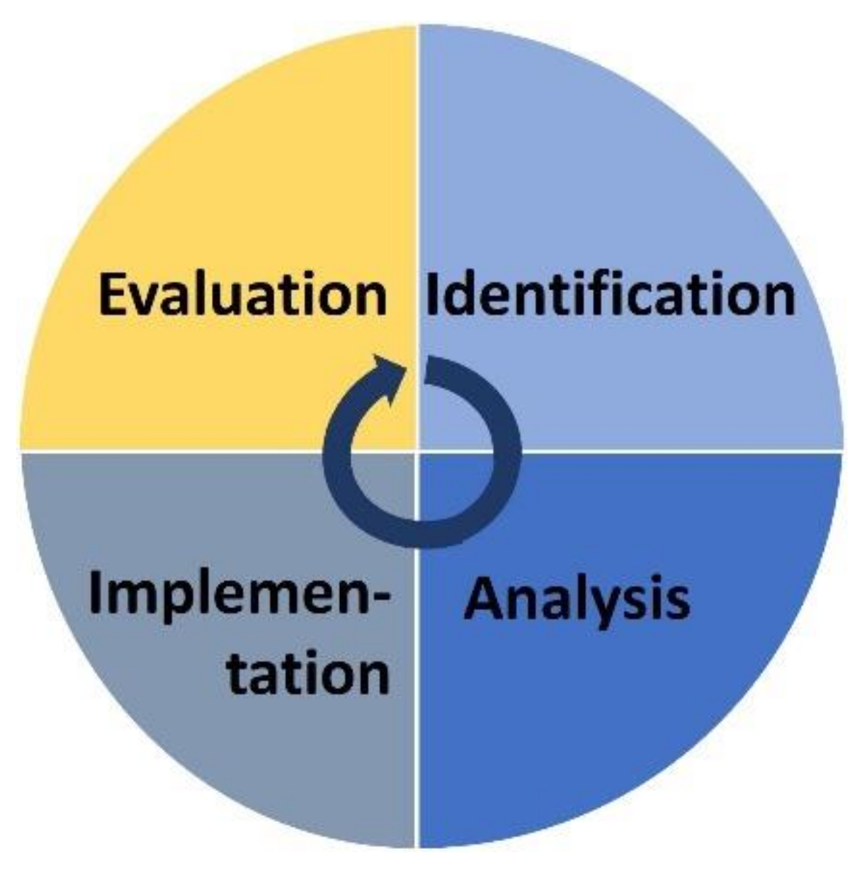
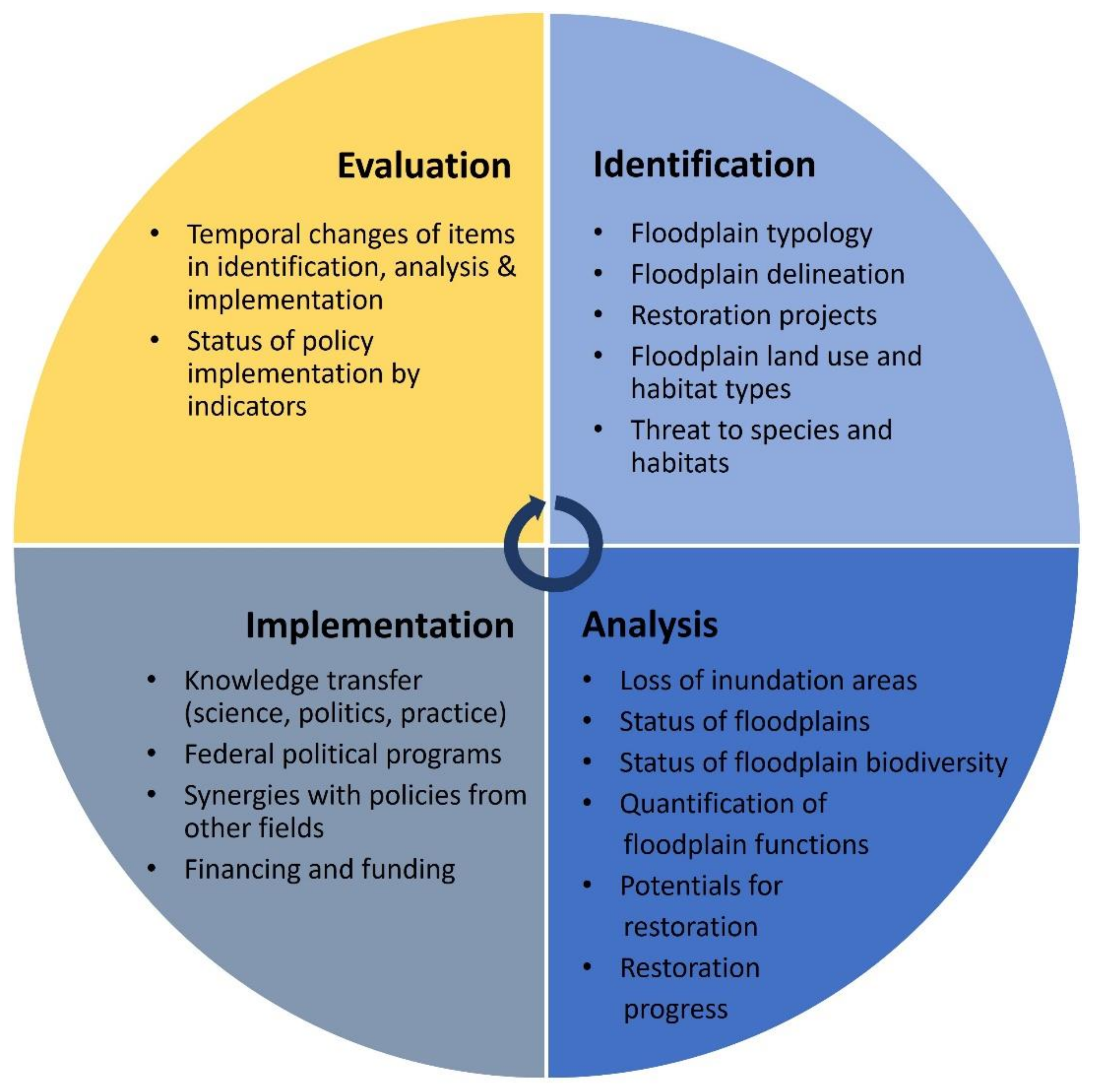
2.1. Development of an Assessment Scheme for Floodplain Management

We developed a scheme to assess floodplain management and applied it here to Germany on the national scale. Hereby, we defined the assessment of floodplain management as an overall concept used to review floodplain-related activities aimed at the protection and improvement of floodplains’ condition.
Relevant floodplain-related activities include research in various thematic fields and the practical implementation of floodplain restoration and monitoring. These are represented in our assessment scheme by the steps of identification, analysis, implementation, and evaluation (Figure 1). The identification step comprises research activities that gather fundamental knowledge on floodplains and related topics. It forms the basis for all further scientific analysis summarized in the analysis step. This is where most deficits become measurable and visible. After this step is completed, the necessary actions can be deduced in the implementation step. This approaches the transfer of scientific results to policies and practice, knowing that there very often is no linear relationship between science and implementation [24]. Whether and how the activities of research and implementation have actually improved the floodplains’ condition nationwide is determined by the evaluation step. Despite the above-mentioned order of the assessment steps there are interactions among all of them. As a result, the assessment should be carried out repeatedly, which is indicated by the arrow.
In order to apply the assessment scheme to Germany, we reviewed the available literature and data on floodplain-related activities in Germany. This enabled us to identify key elements of floodplain management for each of the steps. Conducting the assessment, we checked whether these key elements were suitable to improve the condition of floodplains in Germany and whether knowledge gaps exist.

2.2. Data Acquisition

The thematic focus of our literature and data review was floodplain management at the German national scale including pan-European approaches. We therefore searched international scientific journals and national sources, of which the latter turned out to be the most relevant. In order to include these sources adequately, it was necessary to perform an unsystematic research of the literature and (GIS) data based on expert knowledge.
At the level of applied national research, many of the relevant studies were published in German publication series relevant for practitioners. References to implementation in scientific publications were rare, such that grey literature became an important source. We screened national and international policies and strategies that intersected with floodplain management-related topics. In the evaluation, we additionally analyzed the national database on floodplain restoration projects [25] for further information on the progress of floodplain restoration in Germany.

2.3. Floodplain Definition

For floodplains and their subdivisions, we adopted the definition used by German nationwide studies [26,27]. It separates what are known as ‘morphological floodplains’ into active and former floodplains (Figure 2). Active floodplains can nowadays still become inundated by floods that occur statistically at least once every 100 years. In contrast, former floodplains are cut off from their natural hydrological regime by dikes.

3. Results

The results of the development of the floodplain assessment and its application to Germany are presented in Figure 3. Various key elements of floodplain management were identified for each of the assessment steps. A summarizing table on the key elements and their sources are found in the Supplementary Materials. In the following, the key elements are described on the basis of the assessment scheme. This allowed us to assess how each of the steps and key elements contributed to the improvement of the floodplains’ condition and how they interacted with each other.

3.1. Identification

3.1.1. Floodplain Typology

The nationwide floodplain typology [29] shows the distribution and natural diversity of Germany’s major river floodplains, taking into account that their abiotic characteristics differ depending on landform and parent material. Based on large scale river landscapes and regions, valley slope, and flow regime the floodplain typology differentiates between eleven floodplain types for Germany (Figure 4) and describes their natural reference states: The outermost north-eastern part of Germany is characterized by organic floodplains with low slopes, whereas the rest of the North German Plain is characterized by sand-dominated lowland floodplains. To the Southward, low mountain ranges consist of steep sloped floodplains in basement and cap rocks, with gravel being the predominant substrate. The most dynamic floodplains in terms of morphology can be found in the Alps and the alpine upland. Here, floodplains with crushed rock and steep slopes are widely spread. Currently, additional types of tidally influenced floodplains are being identified for the Federal Agency for Nature Conservation (BfN).
By considering watercourses and floodplains as an inseparable functional unit together with morphological and hydraulic-hydrological aspects, the floodplain typology complements the watercourse typological approaches of the Water Framework Directive 2000/60/EC (WFD) (e.g., [30]) with which there are numerous interfaces. Both typologies provide guidance on developing and meeting ecological restoration targets and offer a basis for type specific ecological assessment. Thereby, the floodplain typology has established itself as a standard for floodplain-related scientific questions and floodplain management in Germany.
Besides the typology specific to Germany detailed above, there is also an EU-wide riverine floodplain typology that was developed by Globevnik et al. [31]. It includes smaller rivers as well and thereby complements the German typology, but is less detailed overall. It distinguishes five floodplain types in Germany: very flat lowland floodplains, flat lowland floodplains, mid altitude low run-off floodplains and highland floodplains. As the scope of the typology is designed to assist pan-European analysis, its relevance for national applications appears to be limited.

3.1.2. Delineation of Floodplains

The first national floodplain delineation was compiled in 2009 by Brunotte et al. [26] for 79 rivers with catchment sizes exceeding 1000 km2 excluding tidal areas. In 2021, the floodplain delineation was revised and supplemented by tidal floodplains using current geodata [34,35]. The morphological floodplains of this updated and more accurate floodplain delineation cover an area of about 16,000 km2 or 4.5% of Germany [35]. Thereof, approximately 5000 km2 are attributed to active floodplains, 10,000 km2 to former floodplains and 1000 km2 to rivers [28].
In recent years, consistent European-wide approaches to delineate riparian zones based on Earth observation data have also been introduced [36,37]. Of the resulting datasets, the Copernicus Land Monitoring Services’ local “riparian zones” component is currently the most complete and detailed [37], also comprising upper reaches and small rivers. For various methodological reasons, the dataset is only partially consistent with the national data.

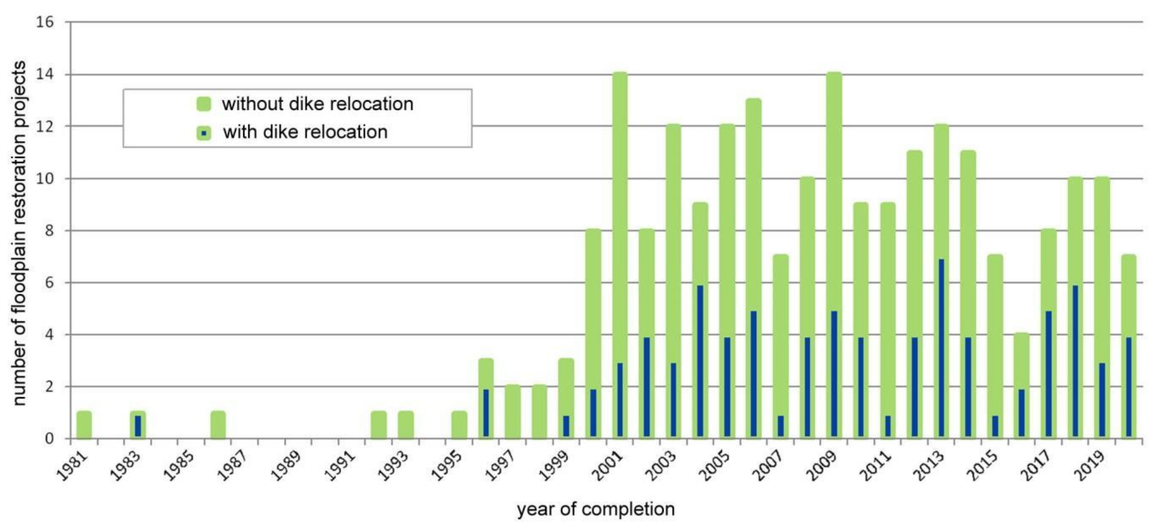
3.1.3. Restoration Projects

Throughout the last decades, floodplain restoration projects have been carried out all over Germany. Completed floodplain restoration projects are collected in a database by the BfN. The database is not restricted to the 79 major rivers, but comprises projects that are located along rivers in Germany that have a federally relevant scope of measures. The projects’ measures increase the dynamics of riverbank and floodplain areas [38,39]. The latest version of the database is from May 2020 and contains 223 restoration projects [25]. Although the project database is not conclusive with regard to either the number of projects or the completeness of the entries, it is suitable to provide a representative overview of floodplain restoration projects for German rivers.

3.1.4. Floodplain Land Use and Habitat Types

Today, the dominant type of land use in Germany’s active floodplains is agricultural. Günther-Diringer et al. [27] identified 43% of the active floodplains as grassland while 26% is arable land. Forests are of minor importance and range, depending on the methodology applied, between less than 10% [40] and 16% [35]. Settlements, transport infrastructure, and commercial facilities make up about 7%. Wetlands and highly characteristic wet grasslands that would naturally occupy large portions of the active floodplains currently cover less than 3%. As for the forests, most cannot be characterized as alluvial forest any longer and approximately 90% of grasslands are intensively used.

3.1.5. Threat to Species and Habitats

Nationwide data on floodplain species and habitats and the threats they face are not collected specifically for floodplains. Nevertheless, the German Red Lists on threatened species and habitats are suitable tools to monitor their exposure over the long term, as list are updated once a decade. Additionally, a homogenous tool was implemented through Natura 2000 to monitor the conservation status of selected habitats throughout Europe every six years. Schindler et al. [14] and Scholz et al. [41] provide overviews of floodplain-typical habitat types listed in Annex I of the Habitats Directive (92/43/EEC). Scholz et al. [41] also list some floodplain typical animals and analyze the degree of conservation for the typical habitats and species at Natura-2000 sites in floodplains.

3.2. Analysis

3.2.1. Loss of Inundation Areas

The nationwide loss of inundation areas can be quantified and monitored on the basis of the nationwide floodplain delineation [27]. Currently, the national average of floodplain loss is 62% caused in particular by the construction of dikes, with significantly higher losses of 80% to 100% in many places along the large rivers Rhine, Elbe, Danube, and Oder [35,42]. Along federal waterways, a network comprising 7300 km, the average loss of undation areas exceeds 75% [43]. These findings are well in line with Weissteiner et al. ([37], p. 16), who identified the vast majority of German riparian zones as “hot spots of riparian extent deficiency”.

3.2.2. Status of Floodplains

The nationwide status of floodplains in Germany can be determined on the basis of the floodplain typology of Koenzen [29] and the national delineation of floodplains [26,27]. The status of floodplains identifies the extent of changes against the potential natural reference state of active floodplains. The nationwide results in 2021 [35] showed that 58% of active floodplains were severely or very severely modified compared to their natural state, meaning that they no longer have a floodplain character and are thus hydrologically disconnected. One-third of the assessed floodplains were significantly modified but still show typical characteristics of floodplains. In many cases, they have considerable potential for ecological improvement. Only 9% of the floodplains have remained in good ecological condition. This poor status is also confirmed by the recently published European preliminary assessment of river floodplain conditions in Europe [31].

3.2.3. Status of Floodplains Biodiversity

There are different approaches to analyzing floodplain biodiversity. According to Scholz et al. [41], 4% of active floodplains in Germany are still very important habitats for typical floodplain biocenosis, 49% are of high to medium importance, and the other half is no longer important for typical floodplain species and habitats. Thus, the results are basically consistent with the results on floodplain status.
An analysis of the current German Red List of Threatened Habitats [18] shows that 80% of the water and floodplain habitat types are threatened, which is well above the average of all habitat types listed (65%). For the habitat types considered in the analysis, the current development is negative for 38% and is positive for 3% [44].
An analysis of the degree of conservation for typical habitats and species in Natura-2000 sites in floodplains by Scholz et al. [41] showed that the degree of conservation was classified as B (good) for about 65% and C (average or reduced) for about 25% based on the number of their occurrences. The distribution was also similar when looking at the share of the area occupied by the habitat types, with C covering slightly less (16%) than A (excellent, 17%). According to the 2019 national report [45] required under the EU Habitats Directive, the conservation status for most typical floodplain habitat types in the Atlantic and Continental Biogeographical Regions was “unfavourable-bad”. It tended to be better in the Alpine Region.

3.2.4. Quantification of Floodplain Functions and Services

While restoration effects or possible scenarios for ecosystem services focused on individual German rivers have been evaluated [46,47], studies evaluating floodplain-related ecosystem services nationwide are scarce. In a study for the BfN, Scholz et al. [41] quantified the functions of flood retention, greenhouse gas retention in organic soils, and nutrient retention and carbon storage in surface biomass of the floodplains delineated in 2009 [26]. In comparison to pristine states, the ecosystem functions decreased between 65% and 80%. Despite these losses, the proxy-based approach estimated that the active floodplains still have the potential to retain about 42,000 t of nitrogen and 1200 t of phosphorus each year. This corresponds to an annual economic benefit of more than EUR 500 million which would have otherwise had to be spent every year in order to avoid diffuse nutrient releases of the same magnitude from agricultural land [41,48]. Even though the results of Natho et al. [49] and Schulz-Zunkel et al. [50] indicate that the nutrient retention determined by Scholz et al. [41] is overestimated, they still support the conclusion that floodplain ecosystems have significant economic potential [48]. Nutrient retention is the ecosystem service monetarized most frequently in Germany although the economic benefits of flood protection and water retention are valuated higher [51].

3.2.5. Potentials for Restoration

Because land use and floodplain ecosystems have adapted to altered hydrologic conditions for centuries it is hardly possible to restore pristine floodplain conditions with extensive floodplain forests in Germany. Nevertheless, if natural dynamics are allowed to return, floodplain ecosystems show a very high potential for regeneration [10] due to their natural characteristics, depending on the disturbances they have experienced. In line with this, recreating hydrologic connectivity and thus enabling morphodynamic processes instead of creating specific habitats is what scientists currently conclude to be fundamental for restoring floodplain functionality (e.g., [52,53,54,55,56]). In consequence, river and floodplain restoration regularly require dike relocations and land use changes in order to improve the floodplain status. The floodplains of the 79 major German rivers hold significant potential for both of these according to the nationwide approaches of Harms et al. [57]. They found that 26% of the active floodplains hold high to very high potential to improve their ecological status through land use changes. Potential reconnection areas, identified using an independent approach, account for 1890 km2, which corresponds to an increase in active floodplains of 41% [58]. This share is exactly the “significant potential for riparian expansion” Weissteiner et al. ([37], p. 17) identified for Europe.

3.2.6. Restoration Progress

There was a significant rise in floodplain restoration in Germany around the year 2000. Of the 223 floodplain restoration projects documented by the BfN [25], 37% include dike relocation measures to different extents (see Figure 5).
From the first floodplain reconnection in 1983 until those of 2020, reconnected floodplains sum up to 7100 ha along the 79 major rivers considered by the floodplain delineation. This corresponds to an increase in active floodplains of about 1.5% [35]. More than 7800 ha of inundation areas were reclaimed by dike relocation projects on all rivers. The relatively small difference between the two numbers demonstrates that the majority of dike relocations take place along the major 79 rivers. Half of the reclaimed areas are located in the Elbe catchment, where also the largest number of dike relocation projects were carried out (in total 3748 ha, n = 30), followed by the Rhine catchment (in total 1909 ha, n = 18). In the Danube River Basin, 14 dike relocation projects were realized but except for one project of 110 ha, the reconnected areas are relatively small. Overall, large-scale projects remain model projects. There are only 21 projects that have each reconnected more than 100 ha to the flooding regime, altogether accounting for 75% of the regained areas.

3.3. Implementation

3.3.1. Knowledge Transfer

The nationwide studies on floodplains assigned to the assessment steps of identification and analysis form a basis for political recommendations in Germany. The transfer of scientific solutions from science to practice was made possible by the BfN’s cooperation with partners like non-governmental organizations, the federal states, and the Federal Waterways and Shipping Administration. Through non-conservation partners and the successful implementation of model projects, the BfN also introduced floodplain conservation in other policy areas. Frequent catastrophic floods also contributed significantly to making it an issue of federal policy, as they triggered broad public and political discussions on floodplains and flood protection and turned the initially ecological or scientific problem of the loss of inundation areas into a political problem [24].

3.3.2. Federal Political Programs

With the German government’s 2013 coalition agreement, the political requirements for the German National Flood Protection Program (NHWSP) [59] and the Federal Government Program “Germany’s Blue Belt” (BBD) [60] were established. Both have been the key programs implementing floodplain restoration activities nationwide and consider synergies between nature conservation and water management. The NHWSP was established in 2014 as a supplement and important component of flood risk management planning under the European Floods Directive [59,61]. Dike relocations are regarded as equivalent to controlled flood retention, like the construction of flood polders and the removal of weak points such as dike improvements [59,61]. Altogether, areas of more than 20,000 ha are planned to be reconnected by dike relocations in the near future [59]. BMUV [62] and Thieken et al. [63] give an overview of funded and planned projects, in which the list of measures is updated regularly. Synergies with the WFD, the status of floodplains and resilience to climate change are taken into account in the identification of measures to be selected and implemented by the federal states.
The BBD was implemented in 2017 as a joint initiative of the federal ministries for transport and for the environment aiming to establish a nationwide habitat network along federal waterways. By 2035, the status classes for 20% of the floodplains around federal waterways should be improved, compared to the results of Brunotte et al. [26], and 15% of the floodplains should be returned to their typical ecological function [60]. Restoration measures are planned for major waterways as ecological stepping stones to be compatible with navigation. Greater ecological potentials can be found in minor waterways that are only scarcely or no longer used for transport and cover a total of 2800 km. Here, more extensive measures are expected to be possible in which ecological concerns can be given priority [43,64]. As far as measure implementation, a change in federal laws in 2021 ascribed specific restoration competences to the Federal Waterways and Shipping Administration to fulfill the requirements of the WFD with regard to hydromorphological measures.
The German government’s 2021 coalition agreement announced the Federal Government’s Action Program for Natural Climate Protection. The program is currently being developed and is expected to further reinforce the reconnection and restoration of floodplain ecosystems in Germany [65].

3.3.3. Synergies with Policies from Other Fields

The political and legal framework for floodplain restoration is also determined decisively by a number of policies which in many cases originate at the European level and are reflected nationally. Due to multiple synergies and benefits of near natural floodplains, objectives for the reconnection of inundation areas and the restoration of floodplain ecosystems can be found in policies from the fields of conservation, water management and adaptation to climate change with many of them interlinked (Table 1).
Of the policies’ objectives listed in Table 1, the European and federal biodiversity strategies are the most concrete when referring to floodplains. Nevertheless, it is also the European Directives that are highly relevant, as their targets are legally binding. The links between WFD and floodplains are only indirect, as many authors described (e.g., [78,79]). That the WFD and the European Nature Directives are adequate to maintain and improve the environmental status of wetlands and waters was concluded by Ignar and Grygoruk [80] and the European Commission, who declared them fit for the purpose [81,82]. Although synergies between the European directions clearly prevail, there are also conflicts between the objectives, emphasizing the importance of integrated approaches [83,84].

3.3.4. Financing and Funding

Apart from political support, financing is a key factor in the implementation of restoration measures. Although having been regularly financed through compensation obligations, e.g., arising from infrastructure projects [38], according to the BfN database on floodplain restoration projects [25], the majority of restoration activities have been financed through public funding. The federal states’ conservation programs have been regularly used, including some floodplain-specific programs and funding programs for flood protection, with some co-financed by the European funds EAFRD (European Agricultural Fund for Rural Development) and ERDF (European regional development fund). Especially larger floodplain restoration projects which in many cases include nature-based solutions for flood protection have regularly been conducted as European LIFE or LIFE+ projects or by using one of the funding programs of the German Federal Ministry of the Environment under supervision of the BfN. These programs are based on the Federation’s authority to fund nationally important model projects focused on conservation and comprise large-scale conservation projects, testing and development projects, and the German Federal Program on Biological Diversity. In 2019, a floodplain-specific funding program was introduced for restoration measures along German Federal Waterways as part of the BBD. Until 2020, nine of the largest dike relocations with a total area of about 3000 ha, i.e., about 40% of the dike relocation area in all of Germany, were realized using one of these funding programs, emphasizing the importance of federal funding [35].

3.4. Evaluation

3.4.1. Temporal Changes of Key Elements in Identification, Analysis, and Implementation

Taking into account data-driven changes between the floodplain delineations of 2009 and 2021, no significant changes in the loss of inundation areas can be recorded at the federal level. Dike relocation projects that have reconnected 4183 ha in the meanwhile have induced local and regional effects but are not sufficient for significant nationwide improvements [35]. The same is true for the status of floodplains. Although extensive restoration projects clearly cause local and regional improvements [27], nationwide effects are limited. The slight differences in the significant to very severe status classes compared to the 2009 results are data-driven and do not represent real changes [35]. Consequently, neither significant improvements nor degradations took place during the last decade (Figure 6).

3.4.2. Status of Policy Implementation

For some federal political targets implementation and achievement are controlled by indicators that are based on the results of nationwide floodplain research. The status of floodplains will be used to evaluate the implementation of the BBD and has already served as the basis for one of the indicators monitoring the implementation of the National Strategy on Biodiversity. The indicator is calculated as an index value and shows for 2021 that the targeted improvement of the nationwide floodplain status by 10%, compared to 2009, cannot be achieved. Rather a data-driven deterioration of 1.5% has occurred [85]. There is no indicator to measure the attainment of the biodiversity strategy’s goal of increasing inundation areas by 10% by 2020. Nevertheless, attainment can be evaluated based on data from the BfN database on floodplain restoration projects [25]. According to that, only 15.3% of the targeted increase has been reclaimed so far. If all dike relocations planned as part of the NHWSP [59] were implemented, 54% of the objectives would be achieved (Figure 7). Thus, another 23,500 ha of inundation areas would have to be reconnected in order to meet the German biodiversity strategy objectives.
The reconnection of former floodplain areas is used as one of the indicators describing and evaluating the impacts of climate change and the adaptation process according to the German Strategy for Adaptation to Climate Change. As the indicator is limited to the floodplains of the 79 major rivers and considers only dike relocations finished by 2017, its latest value [86] differs from our results, which include all projects until 2020.
The legally binding monitoring under the EU Nature Directives and the WFD allows only for indirect conclusions regarding the implementation status of floodplain-related targets. As we pointed out earlier, typical floodplain habitats show predominantly unfavorable conditions in Germany and thus match the results of BMU & BfN [35]. The same is true for the WFD: in 2015 only 6.7% of German river water bodies exhibited “high” and “good ecological status or potential” ([87], nationwide results for 2021 not yet available), which is well below the European average of about 40% (EEA 2018).

4. Discussion

4.1. Validity of the Assessment Scheme for Floodplain Management

To answering the first research question, we developed an assessment scheme to evaluate the approaches for floodplain management on a national scale. We then implemented this assessment on the case study of German floodplains. This was in order to explore the assessment’s scheme validity. This case study showed that the available database was sufficient to conduct a comprehensive assessment of nationwide floodplain management in Germany. As a result, strengths and weaknesses in national floodplain management could be identified, and solutions to overcome still existing challenges were proposed. The literature and data review reported that there are numerous and diverse research activities on floodplains in Germany conducted by research agencies such as universities, non-governmental organizations, and governmental bodies like the German Federal Institute of Hydrology. However, most of the studies were conducted at the local or regional scale while nationwide studies are rare. The majority of the nationwide studies on floodplains were initiated and funded as part of the departmental research of the BfN, the federal government’s scientific authority for nature conservation and landscape management. These studies of applied research systematically build on each other and form the core of the assessment. In consequence, the assessment step of the analysis is directly connected with the previous step of identification. The connection with the implementation step is more indirect, but still present. These findings are right in line with Brunotte et al. [26], Weissteiner et al. [37] and Smith et al. [88], who say that the knowledge of floodplains’ geographical extent and characteristics provides the basis not only for ecological considerations but also for political initiatives and the intertwining of nature conservation and water management policies. The step of evaluation serves to control the effects of floodplain management. It is based on the results of nationwide floodplain research from the assessment steps of identification and analysis. Consequently, the relevant studies need to be updated regularly in order to detect improvements. This is already the case in Germany. The delineation of floodplains and assessment of their status were carried out in 2009 and 2021. As changes are slow, the time interval of approximately 10 years has proven to be suitable [27]. The database on floodplain restoration projects [25] is also updated on a regular basis.

4.2. Key Elements of German Floodplain Management

For Germany, we identified seventeen key elements of floodplain management (Figure 3) which were described in detail in chapter 3, providing the answer to research question two. These seventeen key elements provided an overview of the available knowledge, activities, and ongoing needs to improve the conditions of floodplains in Germany. Eleven key elements were assigned to the assessment steps identification and analysis. These eleven key elements emphasized that strategic floodplain research is an important basis for floodplain management in Germany. Nationwide studies systematically build on each other and provide information on the natural and current characteristics of floodplains, their ecosystem services and restoration. For the key elements of implementation primarily politics was responsible, where actions can be driven by interactions with society and research. According to our results, political support for improved and sustainable floodplain management has improved across Germany in recent years. Such political support is essential for sustainable floodplain management. For the evaluation step two key elements were identified. With directly floodplain-related indicators, Germany goes beyond legal requirements.
An assessment on the basis of key elements also allows a quantitative comparison of floodplain management strategies and their implementation between different countries. However, to our knowledge, Germany’s data bases for the identification and analysis of floodplain management is unique. There are concepts that have been developed and reviewed for the United States [88], but a nationwide approach is still missing. Nevertheless, for floodplain delineation alone there are European [36,37] and eastern US datasets (e.g., [89]). For European floodplains, a delineation, typology and preliminary evaluation of the floodplains’ condition was developed [31]. These supranational approaches, however, lack the detail necessary for them to be applied to national floodplain management, as mentioned earlier.

4.3. A Need for Action in German Floodplain Management

Floodplain management will only be successful when the implementation of scientific knowledge and policies is strong. However, this is where the assessment identifies the main need for action in Germany, which answers research question three. Especially the assessment step evaluation showed that the transition towards sustainable floodplain management is still slow and incomplete. Floodplain-related targets set by policies are ambitious and deficiencies in the condition and functions of floodplains are well known. Still, past and current activities have only induced local and regional improvements regarding the condition of floodplains but have not generated measurable improvements on the national level.
In spite of increased political efforts, and although Germany together with the Netherlands and the United Kingdom has the most dike relocation projects in Europe [90], such projects have only occasionally been implemented. Restoration projects in Germany are site-specific initiatives that are carried out where framework conditions allow [91,92], while the necessary landscape perspective [5] is missing. Furthermore, synergies need to be better and more consistently exploited. Projects that take advantage of synergies between water management and conservation remain isolated cases in Germany [38].
In addition to the two nationwide approaches BBD and NHWSP, climate protection and adaption are new opportunities for floodplain restoration projects that integrate the objectives of water management, nature conservation and climate protection and adaptation. Most recently, politics increasingly demand for functions and services of near-natural floodplains as key elements of natural climate protection and climate adaptation [93]. However, in order to take advantage of the resulting opportunities, the implementation of policy objectives and scientific findings need to be improved. It is due to Germany’s federal system that a national restoration strategy is lacking and responsibilities for floodplain and river management are distributed across different administrative levels. While some federal states have implemented individual floodplain restoration programs, others have not. Federal political programs provide an important impetus for the improvement of floodplain condition in Germany. Despite deficiencies in implementation, the necessary components of a sustainable floodplain management that effectively improves floodplain conditions are present in Germany.

5. Conclusions

The results of our assessment reflect the extensive efforts Germany has undertaken to improve the condition of degraded rivers and floodplains with the aim of generating functional ecosystems with benefits for society, biodiversity, and natural climate protection [14]. The transformation has been promoted by severe flood damages that have occurred frequently since 1990 and further encouraged by the BfN, which provides political decision-makers with national information on floodplains from successive research projects and demonstrates the feasibility of the solutions offered by means of model projects [24]. Giving space to rivers and restoring floodplains are nowadays accepted measures that improve the ecological condition of floodplains and thereby enhance biodiversity and ecosystem services. Moreover, the potential for both the reconnection of floodplain areas and land use changes [57] are considerably greater than the restoration efforts realized or planned thus far. In order to reach floodplain-related objectives in the decades to come it is necessary to improve the implementation of existing policies, particularly aiming at a more synergistic, multifunctional, cooperative, and thus integrative floodplain management. An additional impetus can be expected from the EU restoration law and the Federal Government's Action Program for Natural Climate Protection, which are currently being developed. Already implemented federal political programs like the BBD and NHWSP together with extensive nationwide research on floodplains show that Germany clearly is on the long-term path of transforming floodplains and rivers back to more natural ecosystems.

Supplementary Materials

The following supporting information can be downloaded at: www.mdpi.com/article/10.3390/su141710610/s1, Table S1: Data and studies identified to be key elements for the assessment steps identification and analysis. References [18,25,26,27,28,29,31,33,35,37,38,41,42,44,45,57,94] are cited in the supplementary materials.

Author Contributions

Conceptualization, J.H. and S.N.; Investigation, S.N. and J.H., Resources, J.H. and S.N.; Writing—Original Draft Preparation, S.N. and J.H.; Writing—Review and Editing, J.H. and S.N.; Visualization, S.N. and J.H. All authors have read and agreed to the published version of the manuscript.

Funding

This research was funded by Deutsche Forschungsgemeinschaft project number (390612937).

Data Availability Statement

All data applied in this study can be found in the reference list. Data generated is available upon request.

Conflicts of Interest

The authors declare no conflict of interest.

References

  1. Ward, J.V.; Tockner, K.; Schiemer, F. Biodiversity of floodplains river ecosystems: Ecotones and connectivity. Regul. Rivers Res. Manag. 1999, 15, 125–139. [Google Scholar] [CrossRef]
  2. Naiman, R.J.; Décamps, H. The Ecology of Interfaces: Riparian Zones. Annu. Rev. Ecol. Syst. 1997, 28, 621–658. [Google Scholar] [CrossRef]
  3. Naiman, R.J.; Décamps, H.; McClain, M.E. Riparia: Ecology, Conservation, and Management of Streamside Communities; Elsevier: New York, NY, USA, 2005. [Google Scholar]
  4. Robinson, C.T.; Tockner, K.; Ward, J.V. The fauna of dynamic riverine landscapes. Freshw. Biol. 2002, 47, 661–677. [Google Scholar] [CrossRef]
  5. Naiman, R.J.; Decamps, H.; Pollock, M. The Role of Riparian Corridors in Maintaining Regional Biodiversity; Wiley: Hoboken, NJ, USA, 1993; Volume 3, p. 209. [Google Scholar]
  6. Tockner, K.; Standford, J.A. Riverine flooplains: Present state and future trends. Environ. Conserv. 2002, 29, 308–330. [Google Scholar] [CrossRef]
  7. Tiefenbach, M.; Larndorfer, G.; Weigand, E. Naturschutz in Österreich; Umweltbundesamt: Wien, Austria, 1998. [Google Scholar]
  8. LAU. Arten-und Biotopschutzprogramm Sachsen-Anhalt: Landschaftsraum Elbe. In Sonderheft; LAU: Lauf an der Pegnitz, Germany, 2001; Volume 3/2001. [Google Scholar]
  9. Pedroli, B.; de Blust, G.; van Looy, K.; van Rooij, S. Setting targets in strategies for river restoration. Landsc. Ecol. 2002, 17, 5–18. [Google Scholar] [CrossRef]
  10. Schneider, E.; Werling, M.; Stammel, B.; Januschke, K.; Ledesma-Krist, G.; Scholz, M.; Hering, D.; Gelhaus, M.; Dister, E.; Egger, G. Biodiversität der Flussauen Deutschlands; 163; Bundesamt für Naturschutz: Bonn, Germany, 2017. [Google Scholar]
  11. Scholz, M.; Stab, S.; Dziock, F.; Henle, K. Lebensräume der Elbe und ihrer Auen: Konzepte für die nachhaltige Entwicklung einer Flusslandschaft; Weißensee Verlag: Berlin, Germany, 2005; Volume Band 4. [Google Scholar]
  12. Nilsson, C.; Reidy, C.A.; Dynesius, M.; Revenga, C. Fragmentation and Flow Regulation of the World’s Large River Systems. Science 2005, 308, 405–408. [Google Scholar] [CrossRef]
  13. Tockner, K.; Robinson, C.T.; Uehlinger, U. Rivers of Europe; Elsevier: Amsterdam, The Netherlands, 2009. [Google Scholar] [CrossRef]
  14. Schindler, S.; O’Neill, F.H.; Biró, M.; Damm, C.; Gasso, V.; Kanka, R.; van der Sluis, T.; Krug, A.; Lauwaars, S.G.; Sebesvari, Z.; et al. Multifunctional floodplain management and biodiversity effects: A knowledge synthesis for six European countries. Biodivers. Conserv. 2016, 25, 1349–1382. [Google Scholar] [CrossRef]
  15. Schäfer, A.; Kowatsch, A. Gewässer und Auen—Nutzen für die Gesellschaft; Bundesamt für Naturschutz (BfN): Bonn, Germany, 2015; 58p. [Google Scholar]
  16. Davidson, N. How much wetland has the world lost? Long-term and recent trends in global wetland area. Mar. Freshw. Res. 2014, 65, 936–941. [Google Scholar] [CrossRef]
  17. Ellwanger, G.; Finck, P.; Riecken, U.; Schröder, E. Current assessment of threats to wetland and flootplain habitat types and species in Germany. Nat. Landsch. 2012, 87, 150–155. [Google Scholar]
  18. Finck, P.; Heinze, S.; Raths, U.; Riecken, U.; Ssymank, A.; Fürhaupter, K.; Bildstein, T.; Darr, A.; Boedeker, D. Rote Liste der Gefährdeten Biotoptypen Deutschlands: Dritte fortgeschriebene Fassung 2017; Bundesamt für Naturschutz (BfN): Bonn, Germany, 2017. [Google Scholar]
  19. Tockner, K.; Bunn, S.E.; Gordon, C.; Naiman, R.J.; Quinn, G.P.; Stanford, J.A. Flood plains: Critically threatened ecosystems. In Aquatic Ecosystems—Trends and Global Prospects; Polunin, N.V.C., Ed.; Cambridge University Press: Cambridge, UK, 2008; pp. 45–61. [Google Scholar] [CrossRef]
  20. Costanza, R.; d’Arge, R.; de Groot, R.; Farber, S.; Grasso, M.; Hannon, B.; Limburg, K.; Naeem, S.; O’Neill, R.V.; Paruelo, J.; et al. The value of the world’s ecosystem services and natural capital. Nature 1997, 387, 253–260. [Google Scholar] [CrossRef]
  21. Gordon, B.A.; Dorothy, O.; Lenhart, C.F. Nutrient Retention in Ecologically Functional Floodplains: A Review. Water 2020, 12, 2762. [Google Scholar] [CrossRef]
  22. Opperman, J.J.; Luster, R.; McKenney, B.A.; Roberts, M.; Meadows, A.W. Ecologically Functional Floodplains: Connectivity, Flow Regime, and Scale. JAWRA J. Am. Water Resour. Assoc. 2010, 46, 211–226. [Google Scholar] [CrossRef]
  23. Hartmann, T.; Albrecht, J. From Flood Protection to Flood Risk Management: Condition-Based and Performance-Based Regulations in German Water Law. J. Environ. Law 2014, 26, 243–268. [Google Scholar] [CrossRef]
  24. Heim, J.; Böcher, M.; Krott, M. Alles im Fluss? Bundesweiter Auenschutz in Deutschland aus der Sicht des RIU Modells wissenschaftsbasierter Politikberatung. ZfU 2016, 4, 348–377. [Google Scholar]
  25. BfN. National Database on Floodplain Restoration Projects in Germany. Unpublished Database, Version May 2020, 2020. Available online: https://www.bfn.de/themen/gewaesser-und-auenschutz/gewaesser-und-auenentwicklung/bundesweite-uebersicht.html (accessed on 3 December 2021).
  26. Brunotte, E.; Dister, E.; Günther-Diringer, D.; Koenzen, U.; Mehl, D. Flussauen in Deutschland—Erfassung und Bewertung des Auenzustandes. In Naturschutz und Biologische Vielfalt Heft 87; Katalog: Bonn, Germany, 2009. [Google Scholar]
  27. Günther-Diringer, D.; Berner, K.; Koenzen, U.; Kurth, A.; Modrak, P.; Ackermann, W.; Ehlert, T.; Heyden, J. Methodische Grundlagen zum Auenzustandsbericht 2021: Erfassung, Bilanzierung und Bewertung von Flussauen; BfN-Skripten 591; BfN: Bonn, Germany, 2021. [Google Scholar]
  28. BfN. Flussauen in Deutschland 2021; 2021, WFS Services. Available online: https://geodienste.bfn.de/ogc/wfs/Flussauen_DE_2021 (accessed on 10 February 2022).
  29. Koenzen, U. Fluss und Stromauen in Deutschland—Typologie und Leitbilder. In Angewandte Landschaftsökologie; BfN: Bonn, Germany, 2005; Volume Heft 65. [Google Scholar]
  30. Pottgiesser, T.; Sommerhäuser, M. Fließgewässertypologie Deutschlands: Die Gewässertypen und ihre Steckbriefe als Beitrag zur Umsetzung der EU-Wasserrahmenrichtlinie. In Handbuch der Limnologie; Steinberg, C.W., Calmano, R.-D.W., Klapper, H., Eds.; Wiley: Hoboken, NJ, USA, 2004; Volume 19, pp. 1–16. [Google Scholar]
  31. Globevnik, L.; Januschke, K.; Kail, J.; Snoj, L.; Manfrin, A.; Azlak, M.; Christiansen, T.; Birk, S. Preliminary Assessment of River Floodplain Condition in Europe; Eionet: Copenhagen, Denmark, 2020; p. 121. [Google Scholar]
  32. BfN. Flussauen in Deutschland 2009. In Dataset; Bundesamt für Naturschutz: Bonn, Germany, 2009. [Google Scholar]
  33. BfN. Fachdaten Auentypologie; Bundesamt für Naturschutz: Bonn, Germany, 2005. [Google Scholar]
  34. BMU; BfN. Auenzustandbericht 2021—Flussauen in Deutschland; Bundesamt für Naturschutz: Bonn, Germany, 2021. [Google Scholar]
  35. BMU; BfN. Status Report on Floodplains 2021—Floodplains in Germany; Bundesamt für Naturschutz: Bonn, Germany, 2021. [Google Scholar]
  36. Clerici, N.; Weissteiner, C.J.; Paracchini, M.L.; Boschetti, L.; Baraldi, A.; Strobl, P. Pan-European distribution modelling of stream riparian zones based on multi-source Earth Observation data. Ecol. Indic. 2013, 24, 211–223. [Google Scholar] [CrossRef]
  37. Weissteiner, C.J.; Ickerott, M.; Ott, H.; Probeck, M.; Ramminger, G.; Clerici, N.; Dufourmont, H.; Ribeiro de Sousa, A.M. Europe’s Green Arteries—A Continental Dataset of Riparian Zones. Remote Sens. 2016, 8, 27. [Google Scholar] [CrossRef]
  38. Ehlert, T.; Natho, S. Auenrenaturierung in Deutschland—Analyse zum Stand der Umsetzung anhand einer bundesweiten Datenbank. Auenmagazin 2017, 12, 4–9. [Google Scholar]
  39. BfN. Auenrenaturierungsprojekte an Flüssen in Deutschland. 2022. Available online: https://www.bfn.de/daten-und-fakten/auenrenaturierungsprojekte-fluessen-deutschland-karte-liste (accessed on 24 June 2022).
  40. Natho, S. How Flood Hazard Maps Improve the Understanding of Ecologically Active Floodplains. Water 2021, 13, 937. [Google Scholar] [CrossRef]
  41. Scholz, M.; Mehl, D.; Schulz-Zunkel, C.; Kasperidus, H.D.; Born, W.; Henle, K. Ökosystemfunktionen von Flussauen—Analyse und Bewertung von Hochwasserretention, Nährstoffrückhalt, Kohlenstoff, Treibhausgasemissionen und Habitatfunktion. In Naturschutz und Biologische Vielfalt Heft 124; BfN: Bonn, Germany, 2012. [Google Scholar]
  42. BfN. Verlust von Überschwemmungsflächen; BfN: Bonn, Germany, 2021. [Google Scholar]
  43. AG “Fachliche Grundlagen”. Fachliche Grundlagen zum Bundesprogramm “Blaues Band Deutschland”; BfN: Bonn, Germany, 2016. [Google Scholar]
  44. Deutscher Bundestag. Biodiversität in und an Flüssen. Antwort der Bundesregierung auf die Kleine Anfrage der Abgeordneten Steffi Lemke, Dr. Bettina Hoffmann, Lisa Badum, weiterer Abgeordneter und der Fraktion BÜNDNIS 90/DIE GRÜNEN—Drucksache 19/1128. 2018. Available online: https://dserver.bundestag.de/btd/19/014/1901415.pdf (accessed on 24 June 2022).
  45. Götz, E.; Raths, U.; Benz, A.; Runge, S.; Ackermann, W.; Sachteleben, J. Der nationale Bericht 2019 zur FFH-Richtlinie; Ergebnisse und Bewertung der Erhaltungszustände, Teil 1: Die Lebensraumtypen des Anhangs I und allgemeine Berichtsangaben, Auf Grundlage von Daten der Länder und des Bundes; BfN: Bonn, Germany, 2020. [Google Scholar]
  46. Grossmann, M.; Hartje, V.; Meyerhoff, J. Ökonomische Bewertung naturverträglicher Hochwasservorsorge an der Elbe. In Naturschutz und Biologische Vielfalt Heft 89; BfN: Bonn, Germany, 2010. [Google Scholar]
  47. Mehl, D.; Hoffmann, T.G.; Iwanowski, J.; Lüdecke, K.; Thiele, V. 25 years of restoration of the river Nebel (Mecklenburg): Effects on the ecological status and on the regulative ecosystem services (in German: 25 Jahre Fließgewässerrenaturierung). Hydrol. Und Wasserbewirtsch. 2018, 61, 5–24. [Google Scholar]
  48. Meyerhoff, J.; Angeli, D.; Hartje, V. Valuing the benefits of implementing a national strategy on biological diversity—The case of Germany. Environ. Sci. Policy 2012, 23, 109–119. [Google Scholar] [CrossRef]
  49. Natho, S.; Venohr, M.; Henle, K.; Schulz-Zunkel, C. Modelling nitrogen retention in floodplains with different degrees of degradation for three large rivers in Germany. J. Environ. Manag. 2013, 122, 47–55. [Google Scholar] [CrossRef]
  50. Schulz-Zunkel, C.; Baborowski, M.; Ehlert, T.; Kasperidus, H.D.; Krüger, F.; Horchler, P.; Neukirchen, B.; Rupp, H.; Scholz, M.; Symmank, L.; et al. Simple modelling for a large-scale assessment of total phosphorus retention in the floodplains of large rivers. Wetlands 2021, 41, 68. [Google Scholar] [CrossRef]
  51. Natho, S.; Hudson, P. Accounting for the Value of Ecosystem Services of Floodplains in Germany—A literature review. Ecol. Econ. 2002, 41, 421–429. [Google Scholar]
  52. Beechie, T.; Sear, D.; Olden, J.; Pess, G.; Buffington, J.M.; Moir, H.; Roni, P.; Pollock, M. Process-Based Principles for Restoring River Ecosystems. BioScience 2010, 60, 209–222. [Google Scholar] [CrossRef]
  53. Díaz-Redondo, M.; Egger, G.; Marchamalo, M.; Damm, C.; Oliveira, R.P.; Schmitt, L. Targeting lateral connectivity and morphodynamics in a large river-floodplain system: The upper Rhine River. River Res. Appl. 2018, 34, 734–744. [Google Scholar] [CrossRef]
  54. Formann, E.; Egger, G.; Hauer, C.; Habersack, H. Dynamic disturbance regime approach in river restoration: Concept development and application. Landsc. Ecol. Eng. 2014, 10, 323–337. [Google Scholar] [CrossRef]
  55. Kail, J.; Wolter, C. Analysis and evaluation of large scale river restoration planning in Germany to better link river research and management. River Res. Appl. 2011, 27, 985–999. [Google Scholar] [CrossRef]
  56. Poppe, M.; Kail, J.; Aroviita, J.; Stelmaszczyk, M.; Giełczewski, M.; Muhar, S. Assessing restoration effects on hydromorphology in European mid-sized rivers by key hydromorphological parameters. Hydrobiologia 2016, 769, 21–40. [Google Scholar] [CrossRef]
  57. Harms, O.; Dister, E.; Gerstner, L.; Damm, C.; Egger, G.; Heim, D.; Günther-Diringer, D.; Koenzen, U.; Kurth, A.; Modrak, P. BfN-Skripten 489: Potenziale zur Naturnahen Auenentwicklung—Bundesweiter Überblick und Methodische Empfehlungen für die Herleitung von Entwicklungszielen; BfN: Bonn, Germany, 2018. [Google Scholar]
  58. Ehlert, T.; Neukirchen, B.; Hausmann, B. Perspektiven einer nachhaltigen Auenentwicklung: Prospects for a sustainable development of floodplains. Nat. Und Landsch. 2018, 93, 59–63. [Google Scholar]
  59. LAWA. Nationales Hochwasserschutzprogramm—Kriterien und Bewertungsmaßstäbe für Die Identifikation UND Priorisierung von Wirksamen Maßnahmen Sowie Ein Vorschlag für Die Liste Der Prioritären Maßnahmen zur Verbesserung Des Präventiven Hochwasserschutzes Bund/Länderarbeitsgemeinschaft Wasser; LAWA: Kiel, Germany, 2014. [Google Scholar]
  60. BMVI; BMUB. Bundesprogramm “Blaues Band Deutschland”; Bundesministerium für Verkehr und digitale Infrastruktur, Bundesministerium für Umwelt, Naturschutz, Bau und Reaktorsicherheit: Bonn, Germany, 2017. [Google Scholar]
  61. Buschhüter, E.; Dillen, A.; Menn, K.; Paas, R. Germany’s national programme for flood protection. Nat. Und Landsch. 2018, 93, 50–53. [Google Scholar] [CrossRef]
  62. BMUV. NHWSP—Liste Prioritärer Maßnahmen zur Verbesserung Des Präventiven Hochwasserschutzes; BMUV: Bonn, Germany, 2022. [Google Scholar]
  63. Thieken, A.; Kienzler, S.; Kreibich, H.; Kuhlicke, C.; Kunz, M.; Mühr, B.; Müller, M.; Otto, A.; Petrow, T.; Pisi, S.; et al. Review of the flood risk management system in Germany after the major flood in 2013. Ecol. Soc. 2016, 21, 51. [Google Scholar] [CrossRef]
  64. Anlauf, A. Mehr Natur an Bundeswasserstraßen—Das Bundesprogramm “Blaues Band Deutschland”. In Naturschutz und Landnutzung: Analysen, Diskussionen, Zeitgemäße Lösungen; Bundesverband Beruflicher Naturschutz e.V.: Bonn, Germany, 2017; pp. 118–127. [Google Scholar]
  65. BMUV. Aktionsprogramm Natürlicher Klimaschutz—Eckpunktepapier; BMUV: Bonn, Germany, 2022. [Google Scholar]
  66. EC. EU Biodiversity Strategy for 2030. Bringing Nature back into Our Lives; EC: Brussels, Belgium, 2020; Volume COM(2020) 380 final. [Google Scholar]
  67. BMUB. Nationale Strategie zur Biologischen Vielfalt; BMUB: Bonn, Germany, 2007. [Google Scholar]
  68. EC. Council Directive 92/43/EEC of 21 May 1992 on the Conservation of Natural Habitats and of Wild Fauna and Flora; EC: Brussels, Belgium, 1992. [Google Scholar]
  69. EC. Directive 2009/147/EC of the European Parliament and of the Council of 30 November 2009 on the Conservation of Wild Birds; European Commission: Brussels, Belgium, 2009. [Google Scholar]
  70. BNatSchG. Bundesnaturschutzgesetz Vom 29. Juli 2009 (Bgbl. I S. 2542), Das Zuletzt Durch Artikel 8 Des Gesetzes Vom 13. Mai 2019 (Bgbl. I S. 706) Geändert Worden Ist. Available online: https://www.gesetze-im-internet.de/bnatschg_2009/BNatSchG.pdf (accessed on 4 December 2019).
  71. EC. Green Infrastructure (GI)—Enhancing Europe’s Natural Capital. In COM (2013) 249 Final; European Commission: Brussels, Belgium, 2013. [Google Scholar]
  72. Mayer, F.; Schiller, J. Federal Green Infrastructure Concept—Nature Conservation Foundations for Plans Adopted by the German Federation; Bundesamt für Naturschutz: Bonn, Germany, 2017. [Google Scholar]
  73. EC. Directive 2000/60/EC of the European Parliament and of the Council of 23 October 2000 Establishing a Framework for Community Action in the Field of Water Policy (Water Framework Directive); European Parliament and European Council: Brussels, Belgium, 2000. [Google Scholar]
  74. EC. Directive 2007/60/EC of the European Parliament and of the Council of 23 October 2007 on the Assessment and Management of Flood Risks; European Parliament and European Council: Brussels, Belgium, 2007. [Google Scholar]
  75. WHG. Wasserhaushaltsgesetz vom 31. Juli 2009 (BGBl. I S. 2585), zuletzt geändert durch Gesetz vom 18.08.2021 (BGBl. I S. 3901) m.W.v. 31.08.2021; WHG: Dresden, Germany, 2009. [Google Scholar]
  76. EC. An EU Strategy on Adaptation to Climate Change, COM/2013/0216; European Commission: Brussels, Belgium, 2013. [Google Scholar]
  77. The Federal Government. German Strategy for Adaptation to Climate Change; The Federal Government: Berlin, Germany, 2008. [Google Scholar]
  78. EC. Biodiversity Strategy 2030. Barrier Removal for River Restoration; European Commission: Luxembourg, 2021. [Google Scholar]
  79. Christiansen, T.; Azlak, M.; Ivits-Wasser, E. Floodplains: A Natural System to Preserve and Restore; European Commission: Luxembourg, 2019. [Google Scholar]
  80. Ignar, S.; Grygoruk, M. Wetlands and Water Framework Directive: Protection, Management and Climate Change. In Wetlands and Water Framework Directive; Ignar, S., Grygoruk, M., Eds.; Springer: Berlin/Heidelberg, Germany, 2015; pp. 1–8. [Google Scholar]
  81. EC. Fitness Check of the Water Framework Directive and the Floods Directive; European Commission: Brussels, Belgium, 2019. [Google Scholar]
  82. EC. Commission Staff Working Document: Fitness Check of the EU Nature Legislation (Birds and Habitats Directives). Directive 2009/147/EC of the European Parliament and of the Council of 30 November 2009 on the Conservation of Wild Birds and Council Directive 92/43/EEC of 21 May 1992 on the Conservation of Natural Habitats and of Wild Fauna and Flora; European Commission: Brussels, Belgium, 2016; p. 472. [Google Scholar]
  83. EEA. Flood Risks and Environmental Vulnerability: Exploring the Synergies between Floodplain Restoration, Water Policies and Thematic Policies; EEA: Copenhagen, Denmark, 2016. [Google Scholar]
  84. Janauer, G.A.; Albrecht, J.; Stratmann, L. Synergies and Conflicts Between Water Framework Directive and Natura 2000: Legal Requirements, Technical Guidance and Experiences from Practice. In Wetlands and Water Framework Directive: Protection, Management and Climate Change; Ignar, S., Grygoruk, M., Eds.; Springer: Cham, Switzerland, 2015; pp. 9–29. [Google Scholar]
  85. BMU. Aktiv für die biologische Vielfalt—Rechenschaftsbericht 2021 der Bundesregierung zur Umsetzung der Nationalen Strategie zur Biologischen Vielfalt. 2021. Available online: https://www.bmuv.de/download/rechenschaftsbericht-2021-der-bundesregierung-zur-umsetzung-der-nationalen-strategie-zur-biologischen-vielfalt (accessed on 10 February 2022).
  86. UBA. Monitoringbericht 2019 zur Deutschen Anpassungsstrategie an den Klimawandel; UBA: Dessau-Rosslau, Germany, 2019. [Google Scholar]
  87. BMUB; UBA. Water Framework Directive—The Status of German Waters 2015; Bundesministerium für Umwelt, Naturschutz, Bau und Reaktorsicherheit/Umweltbundesamt: Bonn, Germany; Dessau, Germany, 2016. [Google Scholar]
  88. Smith, M.P.; Schiff, R.; Olivero, A.; MacBroom, J. The Active River Area—A Conservation Framework for Protecting Rivers and Streams; Boston. 2008. Available online: https://www.conservationgateway.org/ConservationByGeography/NorthAmerica/UnitedStates/edc/Documents/ED_freshwater_ARA_NE2008.pdf (accessed on 25 June 2022).
  89. Olivero, A. ARA Riparian Component 2009 Model. 2009. Available online: https://www.conservationgateway.org/ConservationByGeography/NorthAmerica/UnitedStates/edc/reportsdata/freshwater/floodplains/Pages/default.aspx (accessed on 25 June 2022).
  90. Van Staveren, M. Commentary: Dike Relocation from an Environmental Policy Perspective; Springer: Cham, Switzerland, 2019; pp. 181–185. [Google Scholar]
  91. Morandi, B.; Kail, J.; Toedter, A.; Wolter, C.; Piégay, H. Diverse Approaches to Implement and Monitor River Restoration: A Comparative Perspective in France and Germany. Environ. Manag. 2017, 60, 931–946. [Google Scholar] [CrossRef]
  92. Szałkiewicz, E.; Jusik, S.; Grygoruk, M. Status of and Perspectives on River Restoration in Europe: 310,000 Euros per Hectare of Restored River. Sustainability 2018, 10, 129. [Google Scholar] [CrossRef]
  93. Capon, S.J.; Chambers, L.E.; Mac Nally, R.; Naiman, R.J.; Davies, P.; Marshall, N.; Pittock, J.; Reid, M.; Capon, T.; Douglas, M.; et al. Riparian Ecosystems in the 21st Century: Hotspots for Climate Change Adaptation? Ecosystems 2013, 16, 359–381. [Google Scholar] [CrossRef]
  94. CLMS. Delineation of Riparian Zones. 2015. Available online: https://land.copernicus.eu/local/riparian-zones/riparian-zones-delineation.Dataset (accessed on 14 May 2021).
Figure 1. Assessment scheme for floodplain management.
Sustainability 14 10610 g001
Figure 2. Exemplary illustration of a river’s morphological floodplain which can be subdivided into active floodplains and former floodplain areas (unscaled modification based on BfN [28]).
Sustainability 14 10610 g002
Figure 3. Assessment scheme for floodplain management implemented in Germany. Items assigned to the assessment steps represent key elements of German floodplain management.
Sustainability 14 10610 g003
Figure 4. German river basins and typology of floodplains according to Koenzen [29]. Data sources: [32,33], basic spatial data © GeoBasis-DE/ BKG (2014), hillshade derived from European Digital Elevation Model (EU-DEM), version 1.1, © European Union, Copernicus Land Monitoring Service 2016, European Environment Agency (EEA).
Sustainability 14 10610 g004
Figure 5. Number of floodplain restoration projects with (n = 82) and without dike relocation (n = 139) at German rivers listed by the years of completion, updated and modified diagram based on Ehlert and Natho [38].
Sustainability 14 10610 g005
Figure 6. Nationwide status of active floodplains in 2009 and 2021. Differences between 2009 and 2021 do not represent real changes but are data-driven [35].
Sustainability 14 10610 g006
Figure 7. Increase of floodplain areas due to dike relocations until 2020 (n = 82) and additionally planned projects of the National Flood Protection Program (NHWSP, LAWA [59]) measured against the objectives of the National Strategy on Biological Diversity (NBS, [67]). The target value was determined on the basis of the 2021 floodplain delineation [27]. Updated diagram according to Ehlert and Natho [38].
Sustainability 14 10610 g007
Table 1. Objectives concerning floodplain protection and restoration specified by European and related German policies from the fields of conservation, water management, and adaptation to climate change. National policies are listed below the respective European document. 1 Floodplains not explicitly considered, but in the wider sense as key ecosystems 2 Floodplains not explicitly considered, but linked due to ecological interrelations.
PolicyFloodplain Relevant Objectives and Links
EU Biodiversity Strategy
[66]
-
Legally protect at least 30% of the EU’s land area and integrate ecological corridors, as part of a Trans-European Nature Network
-
Restore freshwater ecosystems and the natural functions of rivers in order to archive WFD objectives: at least 25,000 km of free-flowing rivers by 2030 e.g., through restoration of floodplains and wetlands
National Strategy on Biological Diversity [67]
-
By 2020, watercourses and floodplains will be protected in their role as habitats and the typical diversity will be guaranteed
-
Enlarge retention areas of rivers by at least 10% by 2020
EU Habitats & EU Birds Directive [68,69]
-
Achieve or maintain favorable conservation status of habitats and species listed in Annexes I and II
-
Establishment of Natura 2000 network (HD §3, paragraph 1)
-
In Natura 2000 sites: no deterioration of natural habitats or the habitats of species, as well as disturbance of the species for which the areas have been designated (HD §6, paragraph 2)
Federal Nature Conservation Act [70]
-
Protect floodplains from adverse effects and maintain their natural dynamics and self-cleaning ability (§1, paragraph 3)
-
Preservation of floodplains and re-establishment where not present to an adequate extent (§1, paragraph 6)
-
Conservation of floodplain habitats to maintain their network function (§21, paragraph 5)
-
Prohibition of actions that could lead to the destruction or other significant adverse effects of legally protected biotopes with many of them typical for floodplains (§30, paragraph 2)
EU Strategy on Green Infrastructure 1 [71]
-
Strategically planned network of healthy ecosystems (natural and semi-natural areas)
-
Link to Natura 2000
-
EU citizens and biodiversity will benefit from ecosystem services as nature-based green infrastructure solutions
Federal Green Infrastructure Concept [72]
-
Protection, restoration, enlargement and less intensive use of floodplains
-
Considering protected areas and floodplains as the backbone of green infrastructure
-
Link to Federal Government Program “Germany’s Blue Belt”
EU Water Framework Directive—WFD 2 [73]
EU Floods Directive—FD [74]
-
Good ecological status of aquatic ecosystems
-
Prevent deterioration of aquatic ecosystems and, with regard to their water needs, terrestrial ecosystems and wetlands directly depending on the aquatic ecosystems
-
Good chemical status of surface waters
-
Links via groundwater dependent terrestric ecosystems and Natura 2000 sites
-
Improve flood retention e.g., by increasing the floodplain area
-
Use synergies with WFD
Federal Water Act [75]
-
Restoration of former inundation areas that are suitable as retention areas where possible (§77, paragraph 2)
-
Inundation areas (statistically flooded once in 100 years) to be protected with their function to retain floods (§77, paragraph 1)
-
Prohibition of floodplain forest land use change and conversion of grassland into arable land within these areas (§78a)
-
Plans can only be approved if they do not destroy natural retention areas, especially in riparian forests (§68, paragraph 3)
EU Strategy on Adaption to Climate Change [76]
-
Make water management sustainable
-
Use green infrastructure and ecosystem-based approaches for adaption
German Strategy for Adaptation to Climate Change [77]
-
Promote measures with mitigating effects on extreme events (floods and low water situations) like backwater reconnection, dike relocations or other measures to improve hydromorphology
-
Prioritize WFD-measures that maintain or improve the natural adaptive capacity of water bodies including their habitats, e.g., river and floodplain restoration measures, designation of retention areas, appropriate land use
-
Reactivate floodplains and reestablish their dynamics to support wetland species and biotopes that are expected to be particularly affected by summer droughts
Publisher’s Note: MDPI stays neutral with regard to jurisdictional claims in published maps and institutional affiliations.

